Bridge Statistics for Denison, Texas (TX)
Condition, Traffic, Stress, Structural Evaluation, Project Costs
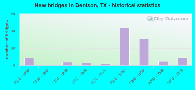
- New bridges - historical statistics
- 91930-1939
- 41950-1959
- 31960-1969
- 21970-1979
- 441980-1989
- 311990-1999
- 52000-2009
- 92010-2019
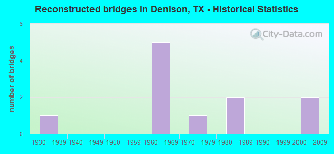
- Reconstructed bridges - Historical Statistics
- 11930-1939
- 01940-1949
- 01950-1959
- 51960-1969
- 11970-1979
- 21980-1989
- 01990-1999
- 22000-2009
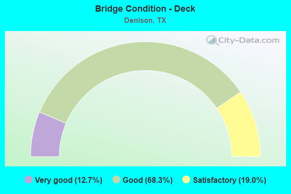
- Bridge Condition - Deck
- 12.7%Very good
- 68.3%Good
- 19.0%Satisfactory
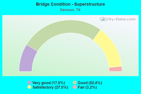
- Bridge Condition - Superstructure
- 17.5%Very good
- 52.4%Good
- 27.0%Satisfactory
- 3.2%Fair
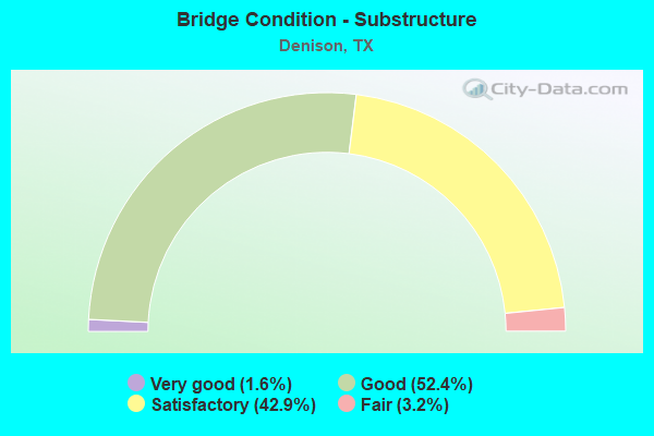
- Bridge Condition - Substructure
- 1.6%Very good
- 52.4%Good
- 42.9%Satisfactory
- 3.2%Fair
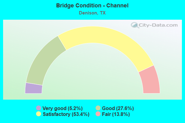
- Bridge Condition - Channel
- 5.2%Very good
- 27.6%Good
- 53.4%Satisfactory
- 13.8%Fair
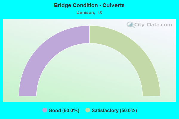
- Bridge Condition - Culverts
- 50.0%Good
- 50.0%Satisfactory
Find on map >> Show street view
Structure Number: 10920004701007, Location: 0.5 MI N OF FM 84 (Lat: 33.791314, Lng: -96.531119), Route carried "on" structure: US 69, Year Built: 1930, Year Reconstructed: 2009, Status: Open, Structure Length: 1.34m (4.40ft), Average Daily Traffic: 3,812 (year 2020), Truck Traffic: 24%, Average Future Daily Traffic: 4,200 (year 2033), Design Load: H 15, Features Intersected: DUCK CREEK
Minimum Vertical Clearance: 30+ m (98+ ft), Kilometerpoint: 19.700, Lanes on structure: 4, Owner: State Highway Agency, Approaching Roadway Width: 25.0m (82.0ft), Skew: 14 degrees, Material/Design: Concrete, Design/Construction: Culvert, Number Of Spans In Main Unit: 4, Length of Maximum Span: 3.0m (9.8ft)
Condition: Channel: Good, Culverts: Good, Operating Rating: 39.9 metric tons, Method Used To Determine Operating Rating: Load Factor (LF), Inventory Rating: 23.6 metric tons, Method Used To Determine Inventory Rating: Load Factor (LF), Structural Evaluation: Equal to present minimum criteria, Waterway Adequacy: Equal to present minimum criteria, Approach Roadway Alignment: Equal to present desirable criteria, Length Of Structure Improvement: 2.07m (6.79ft), Designated Inspection Frequency: Every 24 months, Inspection Date: March 2021, Bridge Improvement Cost: $91,000, Roadway Improvement Cost: $23,000, Total Project Cost: $114,000
Find on map >> Show street view
Structure Number: 10920004701008, Location: 0.2 MI S OF US 75 (Lat: 33.779203, Lng: -96.532058), Route carried "on" structure: US 69, Year Built: 1930, Year Reconstructed: 1943, Status: Open, Structure Length: 0.82m (2.69ft), Average Daily Traffic: 2,839 (year 2020), Truck Traffic: 22%, Average Future Daily Traffic: 2,860 (year 2033), Design Load: H 15, Features Intersected: DUCK CREEK
Minimum Vertical Clearance: 30+ m (98+ ft), Kilometerpoint: 21.045, Lanes on structure: 2, Owner: State Highway Agency, Approaching Roadway Width: 13.4m (44.0ft), Material/Design: Concrete, Design/Construction: Culvert, Number Of Spans In Main Unit: 4, Length of Maximum Span: 1.8m (5.9ft)
Condition: Channel: Satisfactory, Culverts: Satisfactory, Operating Rating: 39.9 metric tons, Method Used To Determine Operating Rating: Load Factor (LF), Inventory Rating: 23.6 metric tons, Method Used To Determine Inventory Rating: Load Factor (LF), Structural Evaluation: Equal to present minimum criteria, Waterway Adequacy: Equal to present minimum criteria, Approach Roadway Alignment: Equal to present desirable criteria, Designated Inspection Frequency: Every 24 months, Inspection Date: March 2021
Find on map >> Show street view
Structure Number: 10920004701052, Location: 1.4 MI S OF RED RIVER (Lat: 33.801342, Lng: -96.538092), Route carried "on" structure: US 75, Year Built: 1991, Status: Open, Structure Length: 11.89m (39.01ft), Average Daily Traffic: 10,880 (year 2010), Truck Traffic: 20%, Average Future Daily Traffic: 19,460 (year 2030), Design Load: HS 20, Features Intersected: US 69 SB
Minimum Vertical Clearance: 30+ m (98+ ft), Kilometerpoint: 4.608, Lanes on structure: 2, Lanes under structure: 3, Owner: State Highway Agency, Approaching Roadway Width: 11.6m (38.1ft), Material/Design: Prestressed concrete, Design/Construction: Stringer/Multi-beam, Number Of Spans In Main Unit: 3, Number Of Approach Spans: 2, Length of Maximum Span: 33.5m (109.9ft), Curb-To-Curb Width: 11.3m (37.1ft), Out-to-Out Width: 12.2m (40.0ft)
Condition: Deck: Satisfactory, Superstructure: Very good, Substructure: Good, Operating Rating: 58.0 metric tons, Method Used To Determine Operating Rating: Load Factor (LF), Inventory Rating: 34.5 metric tons, Method Used To Determine Inventory Rating: Load Factor (LF), Structural Evaluation: Better than present minimum criteria, Deck Geometry: Somewhat better than minimum adequacy, Underclear: Better than present minimum criteria, Approach Roadway Alignment: Equal to present desirable criteria, Designated Inspection Frequency: Every 24 months, Inspection Date: May 2021, Deck Structure Type: Concrete Cast-file-Place
Find on map >> Show street view
Structure Number: 10920004701152, Location: 0.2 MI S OF FM 84 (Lat: 33.779219, Lng: -96.532247), Route carried "on" structure: US 69, Year Built: 1962, Status: Open, Structure Length: 0.82m (2.69ft), Average Daily Traffic: 2,516 (year 2020), Truck Traffic: 22%, Average Future Daily Traffic: 2,860 (year 2033), Design Load: HS 20, Features Intersected: DUCK CRK
Minimum Vertical Clearance: 30+ m (98+ ft), Kilometerpoint: 21.044, Lanes on structure: 2, Owner: State Highway Agency, Approaching Roadway Width: 11.6m (38.1ft), Skew: 1 degrees, Material/Design: Concrete, Design/Construction: Culvert, Number Of Spans In Main Unit: 4, Length of Maximum Span: 1.8m (5.9ft)
Condition: Channel: Good, Culverts: Satisfactory, Operating Rating: 39.9 metric tons, Method Used To Determine Operating Rating: Load Factor (LF), Inventory Rating: 23.6 metric tons, Method Used To Determine Inventory Rating: Load Factor (LF), Structural Evaluation: Equal to present minimum criteria, Waterway Adequacy: Equal to present minimum criteria, Approach Roadway Alignment: Equal to present desirable criteria, Designated Inspection Frequency: Every 24 months, Inspection Date: March 2021
Find on map >> Show street view
Structure Number: 10920004701353, Location: 0.8 MI S OF RED RIVER (Lat: 33.809256, Lng: -96.534633), Route carried "on" structure: US 69, Year Built: 1991, Status: Open, Structure Length: 9.14m (29.99ft), Average Daily Traffic: 19,396 (year 2020), Truck Traffic: 22%, Average Future Daily Traffic: 21,380 (year 2033), Design Load: HS 20, Features Intersected: J-M CROSSOVER, Facility Carried by Structure: US 75 NB
Minimum Vertical Clearance: 30+ m (98+ ft), Kilometerpoint: 17.263, Lanes on structure: 2, Lanes under structure: 3, Owner: State Highway Agency, Approaching Roadway Width: 11.6m (38.1ft), Material/Design: Prestressed concrete, Design/Construction: Stringer/Multi-beam, Number Of Spans In Main Unit: 1, Number Of Approach Spans: 4, Length of Maximum Span: 27.4m (89.9ft), Curb-To-Curb Width: 11.3m (37.1ft), Out-to-Out Width: 12.2m (40.0ft)
Condition: Deck: Good, Superstructure: Good, Substructure: Good, Operating Rating: 58.0 metric tons, Method Used To Determine Operating Rating: Load Factor (LF), Inventory Rating: 34.5 metric tons, Method Used To Determine Inventory Rating: Load Factor (LF), Structural Evaluation: Better than present minimum criteria, Deck Geometry: Equal to present minimum criteria, Underclear: Superior to present desirable criteria, Approach Roadway Alignment: Equal to present desirable criteria, Designated Inspection Frequency: Every 24 months, Inspection Date: May 2021, Deck Structure Type: Concrete Cast-file-Place
Find on map >> Show street view
Structure Number: 10920004701354, Location: 0.8 MI S OF RED RIVER (Lat: 33.809258, Lng: -96.534839), Route carried "on" structure: US 69, Year Built: 1991, Status: Open, Structure Length: 9.14m (29.99ft), Average Daily Traffic: 23,878 (year 2020), Truck Traffic: 22%, Average Future Daily Traffic: 21,380 (year 2033), Design Load: HS 20, Features Intersected: J-M CROSSOVER, Facility Carried by Structure: US 75 SB
Minimum Vertical Clearance: 30+ m (98+ ft), Kilometerpoint: 17.263, Lanes on structure: 2, Lanes under structure: 3, Owner: State Highway Agency, Approaching Roadway Width: 11.6m (38.1ft), Material/Design: Prestressed concrete, Design/Construction: Stringer/Multi-beam, Number Of Spans In Main Unit: 1, Number Of Approach Spans: 4, Length of Maximum Span: 27.4m (89.9ft), Curb-To-Curb Width: 11.3m (37.1ft), Out-to-Out Width: 12.2m (40.0ft)
Condition: Deck: Satisfactory, Superstructure: Good, Substructure: Good, Operating Rating: 58.0 metric tons, Method Used To Determine Operating Rating: Load Factor (LF), Inventory Rating: 34.5 metric tons, Method Used To Determine Inventory Rating: Load Factor (LF), Structural Evaluation: Better than present minimum criteria, Deck Geometry: Equal to present minimum criteria, Underclear: Superior to present desirable criteria, Approach Roadway Alignment: Equal to present desirable criteria, Designated Inspection Frequency: Every 24 months, Inspection Date: May 2021, Deck Structure Type: Concrete Cast-file-Place
Find on map >> Show street view
Structure Number: 10920004701383, Location: 1.4 MI S OF RED RIVER (Lat: 33.802358, Lng: -96.537397), Route carried "on" structure: US 75, Year Built: 1991, Status: Open, Structure Length: 11.89m (39.01ft), Average Daily Traffic: 10,880 (year 2011), Truck Traffic: 27%, Average Future Daily Traffic: 19,460 (year 2031), Design Load: HS 20, Features Intersected: US 69 SB
Minimum Vertical Clearance: 30+ m (98+ ft), Kilometerpoint: 4.608, Lanes on structure: 2, Lanes under structure: 3, Owner: State Highway Agency, Approaching Roadway Width: 11.6m (38.1ft), Skew: 9 degrees, Material/Design: Prestressed concrete, Design/Construction: Stringer/Multi-beam, Number Of Spans In Main Unit: 3, Number Of Approach Spans: 2, Length of Maximum Span: 33.5m (109.9ft), Curb-To-Curb Width: 11.3m (37.1ft), Out-to-Out Width: 12.2m (40.0ft)
Condition: Deck: Satisfactory, Superstructure: Good, Substructure: Satisfactory, Operating Rating: 58.0 metric tons, Method Used To Determine Operating Rating: Load Factor (LF), Inventory Rating: 34.5 metric tons, Method Used To Determine Inventory Rating: Load Factor (LF), Structural Evaluation: Equal to present minimum criteria, Deck Geometry: Somewhat better than minimum adequacy, Underclear: Better than present minimum criteria, Approach Roadway Alignment: Equal to present desirable criteria, Designated Inspection Frequency: Every 24 months, Inspection Date: May 2021, Deck Structure Type: Concrete Cast-file-Place
Find on map >> Show street view
Structure Number: 10920004701398, Location: TEXAS OKLAHOMA BORDER (Lat: 33.822106, Lng: -96.533531), Route carried "on" structure: US 69, Year Built: 1996, Status: Open, Structure Length: 37.80m (124.02ft), Average Daily Traffic: 23,878 (year 2020), Truck Traffic: 22%, Average Future Daily Traffic: 21,380 (year 2033), Design Load: HS 20, Features Intersected: RED RIVER
Minimum Vertical Clearance: 30+ m (98+ ft), Kilometerpoint: 15.715, Lanes on structure: 2, Owner: State Highway Agency, Approaching Roadway Width: 11.6m (38.1ft), Skew: 3 degrees, Material/Design: Prestressed concrete, Design/Construction: Stringer/Multi-beam, Number Of Spans In Main Unit: 10, Length of Maximum Span: 39.6m (129.9ft), Curb-To-Curb Width: 11.3m (37.1ft), Out-to-Out Width: 12.2m (40.0ft)
Condition: Deck: Good, Superstructure: Good, Substructure: Good, Channel: Satisfactory, Operating Rating: 68.0 metric tons, Method Used To Determine Operating Rating: Load Factor (LF), Inventory Rating: 38.1 metric tons, Method Used To Determine Inventory Rating: Load Factor (LF), Structural Evaluation: Better than present minimum criteria, Deck Geometry: Equal to present minimum criteria, Waterway Adequacy: Superior to present desirable criteria, Approach Roadway Alignment: Equal to present desirable criteria, Length Of Structure Improvement: 45.72m (150.00ft), Designated Inspection Frequency: Every 24 months, Inspection Date: June 2021, Bridge Improvement Cost: $1,500,000, Total Project Cost: $1,500,000, Deck Structure Type: Concrete Cast-file-Place
Find on map >> Show street view
Structure Number: 10920004701399, Location: TEXAS OKLAHOMA BORDER (Lat: 33.822097, Lng: -96.533172), Route carried "on" structure: US 69, Year Built: 1997, Status: Open, Structure Length: 36.88m (121.00ft), Average Daily Traffic: 19,396 (year 2020), Truck Traffic: 22%, Average Future Daily Traffic: 21,380 (year 2033), Design Load: HS 20, Features Intersected: RED RIVER
Minimum Vertical Clearance: 30+ m (98+ ft), Kilometerpoint: 15.715, Lanes on structure: 2, Owner: State Highway Agency, Approaching Roadway Width: 11.6m (38.1ft), Skew: 3 degrees, Material/Design: Prestressed concrete, Design/Construction: Stringer/Multi-beam, Number Of Spans In Main Unit: 10, Length of Maximum Span: 39.6m (129.9ft), Curb-To-Curb Width: 11.3m (37.1ft), Out-to-Out Width: 12.2m (40.0ft)
Condition: Deck: Good, Superstructure: Good, Substructure: Good, Channel: Good, Operating Rating: 68.0 metric tons, Method Used To Determine Operating Rating: Load Factor (LF), Inventory Rating: 38.1 metric tons, Method Used To Determine Inventory Rating: Load Factor (LF), Structural Evaluation: Better than present minimum criteria, Deck Geometry: Equal to present minimum criteria, Waterway Adequacy: Superior to present desirable criteria, Approach Roadway Alignment: Equal to present desirable criteria, Length Of Structure Improvement: 45.72m (150.00ft), Designated Inspection Frequency: Every 24 months, Inspection Date: June 2021, Bridge Improvement Cost: $1,500,000, Total Project Cost: $1,500,000, Deck Structure Type: Concrete Cast-file-Place
Find on map >> Show street view
Structure Number: 10920004702079, Location: 0.2 MI S OF SP 503 (Lat: 33.717369, Lng: -96.560361), Route carried "on" structure: State highway 91, Year Built: 1955, Year Reconstructed: 1985, Status: Open, Structure Length: 5.33m (17.49ft), Average Daily Traffic: 5,622 (year 2020), Truck Traffic: 25%, Average Future Daily Traffic: 6,410 (year 2033), Features Intersected: IRON ORE CREEK
Minimum Vertical Clearance: 30+ m (98+ ft), Kilometerpoint: 12.936, Lanes on structure: 2, Owner: State Highway Agency, Approaching Roadway Width: 12.8m (42.0ft), Material/Design: Concrete, Design/Construction: Slab, Number Of Spans In Main Unit: 7, Length of Maximum Span: 7.6m (24.9ft), Curb-To-Curb Width: 15.6m (51.2ft), Out-to-Out Width: 16.5m (54.1ft)
Condition: Deck: Good, Superstructure: Good, Substructure: Satisfactory, Channel: Satisfactory, Operating Rating: 48.1 metric tons, Method Used To Determine Operating Rating: Load Factor (LF), Inventory Rating: 29.0 metric tons, Method Used To Determine Inventory Rating: Load Factor (LF), Structural Evaluation: Equal to present minimum criteria, Deck Geometry: Superior to present desirable criteria, Waterway Adequacy: Equal to present minimum criteria, Approach Roadway Alignment: Equal to present desirable criteria, Length Of Structure Improvement: 5.33m (17.49ft), Designated Inspection Frequency: Every 24 months, Inspection Date: March 2021, Bridge Improvement Cost: $539,000, Roadway Improvement Cost: $179,000, Total Project Cost: $718,000, Deck Structure Type: Concrete Cast-file-Place, Wearing Surface/Protective System: Wearing Surface: Bituminous
Find on map >> Show street view
Structure Number: 10920004702257, Location: 0.2 MI S OF SP 503 (Lat: 33.717781, Lng: -96.560872), Route carried "on" structure: State highway 91, Year Built: 1984, Status: Open, Structure Length: 5.94m (19.49ft), Average Daily Traffic: 5,315 (year 2020), Truck Traffic: 25%, Average Future Daily Traffic: 6,410 (year 2033), Design Load: HS 20, Features Intersected: IRON ORE CREEK
Minimum Vertical Clearance: 30+ m (98+ ft), Kilometerpoint: 12.942, Lanes on structure: 3, Owner: State Highway Agency, Approaching Roadway Width: 14.0m (45.9ft), Material/Design: Prestressed concrete, Design/Construction: Stringer/Multi-beam, Number Of Spans In Main Unit: 3, Length of Maximum Span: 19.8m (65.0ft), Curb-To-Curb Width: 13.8m (45.3ft), Out-to-Out Width: 14.6m (47.9ft)
Condition: Deck: Good, Superstructure: Good, Substructure: Good, Channel: Good, Operating Rating: 65.3 metric tons, Method Used To Determine Operating Rating: Load Factor (LF), Inventory Rating: 39.0 metric tons, Method Used To Determine Inventory Rating: Load Factor (LF), Structural Evaluation: Better than present minimum criteria, Deck Geometry: High priority of corrective action, Waterway Adequacy: Equal to present minimum criteria, Approach Roadway Alignment: Equal to present desirable criteria, Designated Inspection Frequency: Every 24 months, Inspection Date: March 2021, Deck Structure Type: Concrete Precast Panels
Find on map >> Show street view
Structure Number: 10920004702626, Location: 0.8 MI N OF SP 503 (Lat: 33.750289, Lng: -96.537150), Route carried "on" structure: US 69, Year Built: 2013, Status: Open, Structure Length: 49.07m (160.99ft), Average Daily Traffic: 6,728 (year 2020), Truck Traffic: 24%, Average Future Daily Traffic: 7,520 (year 2033), Design Load: HL 93, Features Intersected: BNSF & UPRR
Minimum Vertical Clearance: 30+ m (98+ ft), Kilometerpoint: 7.998, Lanes on structure: 2, Lanes under structure: 3, Owner: State Highway Agency, Approaching Roadway Width: 7.3m (24.0ft), Skew: 10 degrees, Material/Design: Prestressed concrete, Design/Construction: Stringer/Multi-beam, Number Of Spans In Main Unit: 13, Number Of Approach Spans: 5, Length of Maximum Span: 34.1m (111.9ft), Curb or Sidewalk Widths: Left: 0.0m, Right: 1.8m (5.9ft), Curb-To-Curb Width: 7.3m (24.0ft), Out-to-Out Width: 11.6m (38.1ft)
Condition: Deck: Good, Superstructure: Good, Substructure: Good, Channel: Good, Operating Rating: 54.4 metric tons, Method Used To Determine Operating Rating: Assigned ratings based on Load and Resistance Factor Design (LRFD) reported in metric tons, Inventory Rating: 32.7 metric tons, Method Used To Determine Inventory Rating: Assigned ratings based on Load and Resistance Factor Design (LRFD) reported in metric tons, Structural Evaluation: Better than present minimum criteria, Deck Geometry: High priority of replacement, Underclear: Superior to present desirable criteria, Approach Roadway Alignment: Equal to present desirable criteria, Designated Inspection Frequency: Every 24 months, Inspection Date: March 2021, Deck Structure Type: Concrete Precast Panels
Find on map >> Show street view
Structure Number: 10920004702627, Location: 0.8 MI N OF SP 503 (Lat: 33.750289, Lng: -96.537150), Route carried "on" structure: US 69, Year Built: 2013, Status: Open, Structure Length: 49.07m (160.99ft), Average Daily Traffic: 6,643 (year 2020), Truck Traffic: 24%, Average Future Daily Traffic: 7,520 (year 2033), Design Load: HL 93, Features Intersected: BNSF & UPRR
Minimum Vertical Clearance: 30+ m (98+ ft), Kilometerpoint: 7.998, Lanes on structure: 2, Lanes under structure: 3, Owner: State Highway Agency, Approaching Roadway Width: 7.3m (24.0ft), Skew: 10 degrees, Material/Design: Prestressed concrete, Design/Construction: Stringer/Multi-beam, Number Of Spans In Main Unit: 12, Number Of Approach Spans: 7, Length of Maximum Span: 34.1m (111.9ft), Curb or Sidewalk Widths: Left: 0.0m, Right: 1.8m (5.9ft), Curb-To-Curb Width: 7.3m (24.0ft), Out-to-Out Width: 11.6m (38.1ft)
Condition: Deck: Good, Superstructure: Good, Substructure: Good, Channel: Good, Operating Rating: 54.4 metric tons, Method Used To Determine Operating Rating: Assigned ratings based on Load and Resistance Factor Design (LRFD) reported in metric tons, Inventory Rating: 32.7 metric tons, Method Used To Determine Inventory Rating: Assigned ratings based on Load and Resistance Factor Design (LRFD) reported in metric tons, Structural Evaluation: Better than present minimum criteria, Deck Geometry: High priority of replacement, Underclear: Better than present minimum criteria, Approach Roadway Alignment: Equal to present desirable criteria, Designated Inspection Frequency: Every 24 months, Inspection Date: March 2021, Deck Structure Type: Concrete Precast Panels
Find on map >> Show street view
Structure Number: 10920004712255, Location: 1.50 MI E OF US 75 (Lat: 33.720414, Lng: -96.558450), Route carried "on" structure: State highway 91, Year Built: 1984, Status: Open, Structure Length: 9.30m (30.51ft), Average Daily Traffic: 4,070 (year 2013), Truck Traffic: 10%, Average Future Daily Traffic: 5,700 (year 2033), Design Load: HS 20, Features Intersected: SPUR 503
Minimum Vertical Clearance: 30+ m (98+ ft), Kilometerpoint: 4.204, Lanes on structure: 3, Lanes under structure: 3, Owner: State Highway Agency, Approaching Roadway Width: 14.0m (45.9ft), Skew: 4 degrees, Material/Design: Prestressed concrete, Design/Construction: Stringer/Multi-beam, Number Of Spans In Main Unit: 2, Number Of Approach Spans: 2, Length of Maximum Span: 32.0m (105.0ft), Curb-To-Curb Width: 13.8m (45.3ft), Out-to-Out Width: 14.6m (47.9ft)
Condition: Deck: Good, Superstructure: Very good, Substructure: Satisfactory, Operating Rating: 56.2 metric tons, Method Used To Determine Operating Rating: Load Factor (LF), Inventory Rating: 33.6 metric tons, Method Used To Determine Inventory Rating: Load Factor (LF), Structural Evaluation: Equal to present minimum criteria, Deck Geometry: Somewhat better than minimum adequacy, Underclear: Somewhat better than minimum adequacy, Approach Roadway Alignment: Equal to present desirable criteria, Designated Inspection Frequency: Every 24 months, Inspection Date: March 2021, Deck Structure Type: Concrete Precast Panels
Find on map >> Show street view
Structure Number: 10920004712256, Location: 1.50 MI E OF US 75 (Lat: 33.720281, Lng: -96.559131), Route carried "on" structure: State highway 91, Year Built: 1984, Status: Open, Structure Length: 7.92m (25.98ft), Average Daily Traffic: 4,070 (year 2013), Truck Traffic: 10%, Average Future Daily Traffic: 5,700 (year 2033), Design Load: HS 20, Features Intersected: SPUR 503
Minimum Vertical Clearance: 30+ m (98+ ft), Kilometerpoint: 4.175, Lanes on structure: 2, Lanes under structure: 3, Owner: State Highway Agency, Approaching Roadway Width: 11.6m (38.1ft), Skew: 3 degrees, Material/Design: Prestressed concrete, Design/Construction: Stringer/Multi-beam, Number Of Spans In Main Unit: 2, Number Of Approach Spans: 2, Length of Maximum Span: 27.4m (89.9ft), Curb-To-Curb Width: 11.3m (37.1ft), Out-to-Out Width: 12.2m (40.0ft)
Condition: Deck: Good, Superstructure: Good, Substructure: Good, Operating Rating: 68.0 metric tons, Method Used To Determine Operating Rating: Load Factor (LF), Inventory Rating: 40.8 metric tons, Method Used To Determine Inventory Rating: Load Factor (LF), Structural Evaluation: Better than present minimum criteria, Deck Geometry: Equal to present minimum criteria, Underclear: Equal to present minimum criteria, Approach Roadway Alignment: Equal to present desirable criteria, Designated Inspection Frequency: Every 24 months, Inspection Date: March 2021, Deck Structure Type: Concrete Precast Panels
Find on map >> Show street view
Structure Number: 10920004718241, Location: 0.60 MI N OF FM 691 (Lat: 33.717853, Lng: -96.588100), Route carried "on" structure: ServiceUS 75, Year Built: 1984, Status: Open, Structure Length: 4.27m (14.01ft), Average Daily Traffic: 950 (year 2013), Truck Traffic: 14%, Average Future Daily Traffic: 1,330 (year 2033), Design Load: HS 20, Features Intersected: IRON ORE CREEK
Minimum Vertical Clearance: 30+ m (98+ ft), Kilometerpoint: 16.372, Lanes on structure: 2, Owner: State Highway Agency, Approaching Roadway Width: 10.4m (34.1ft), Skew: 2 degrees, Material/Design: Prestressed concrete, Design/Construction: Stringer/Multi-beam, Number Of Spans In Main Unit: 2, Length of Maximum Span: 21.0m (68.9ft), Curb-To-Curb Width: 10.7m (35.1ft), Out-to-Out Width: 11.6m (38.1ft)
Condition: Deck: Good, Superstructure: Very good, Substructure: Good, Channel: Good, Operating Rating: 68.0 metric tons, Method Used To Determine Operating Rating: Load Factor (LF), Inventory Rating: 40.8 metric tons, Method Used To Determine Inventory Rating: Load Factor (LF), Structural Evaluation: Better than present minimum criteria, Deck Geometry: Somewhat better than minimum adequacy, Waterway Adequacy: Better than present minimum criteria, Approach Roadway Alignment: Equal to present desirable criteria, Designated Inspection Frequency: Every 24 months, Inspection Date: June 2021, Deck Structure Type: Concrete Precast Panels
Find on map >> Show street view
Structure Number: 10920004718246, Location: 0.6 MI N OF FM 691 (Lat: 33.717614, Lng: -96.585483), Route carried "on" structure: US 75, Year Built: 1987, Status: Open, Structure Length: 4.27m (14.01ft), Average Daily Traffic: 32,584 (year 2020), Truck Traffic: 14%, Average Future Daily Traffic: 31,520 (year 2033), Design Load: HS 20, Features Intersected: IRON ORE CREEK
Minimum Vertical Clearance: 30+ m (98+ ft), Kilometerpoint: 16.348, Lanes on structure: 2, Owner: State Highway Agency, Approaching Roadway Width: 11.6m (38.1ft), Material/Design: Prestressed concrete, Design/Construction: Stringer/Multi-beam, Number Of Spans In Main Unit: 2, Length of Maximum Span: 21.0m (68.9ft), Curb-To-Curb Width: 11.3m (37.1ft), Out-to-Out Width: 12.2m (40.0ft)
Condition: Deck: Satisfactory, Superstructure: Good, Substructure: Good, Channel: Satisfactory, Operating Rating: 59.0 metric tons, Method Used To Determine Operating Rating: Load Factor (LF), Inventory Rating: 34.5 metric tons, Method Used To Determine Inventory Rating: Load Factor (LF), Structural Evaluation: Better than present minimum criteria, Deck Geometry: Somewhat better than minimum adequacy, Waterway Adequacy: Equal to present minimum criteria, Approach Roadway Alignment: Equal to present desirable criteria, Designated Inspection Frequency: Every 24 months, Inspection Date: June 2021, Deck Structure Type: Concrete Cast-file-Place
Find on map >> Show street view
Structure Number: 10920004718247, Location: 0.6 MI N OF FM 691 (Lat: 33.717589, Lng: -96.585269), Route carried "on" structure: US 75, Year Built: 1984, Status: Open, Structure Length: 4.27m (14.01ft), Average Daily Traffic: 27,718 (year 2020), Truck Traffic: 14%, Average Future Daily Traffic: 31,520 (year 2033), Design Load: HS 20, Features Intersected: IRON ORE CREEK
Minimum Vertical Clearance: 30+ m (98+ ft), Kilometerpoint: 16.348, Lanes on structure: 2, Owner: State Highway Agency, Approaching Roadway Width: 12.2m (40.0ft), Material/Design: Prestressed concrete, Design/Construction: Stringer/Multi-beam, Number Of Spans In Main Unit: 2, Length of Maximum Span: 21.0m (68.9ft), Curb-To-Curb Width: 12.4m (40.7ft), Out-to-Out Width: 14.2m (46.6ft)
Condition: Deck: Good, Superstructure: Good, Substructure: Good, Channel: Satisfactory, Operating Rating: 68.0 metric tons, Method Used To Determine Operating Rating: Load Factor (LF), Inventory Rating: 40.8 metric tons, Method Used To Determine Inventory Rating: Load Factor (LF), Structural Evaluation: Better than present minimum criteria, Deck Geometry: Better than present minimum criteria, Waterway Adequacy: Equal to present minimum criteria, Approach Roadway Alignment: Equal to present desirable criteria, Designated Inspection Frequency: Every 24 months, Inspection Date: June 2021, Deck Structure Type: Concrete Precast Panels
Find on map >> Show street view
Structure Number: 10920004718248, Location: 0.60 MI N OF FM 691 (Lat: 33.717625, Lng: -96.584936), Route carried "on" structure: ServiceUS 75, Year Built: 1984, Status: Open, Structure Length: 4.27m (14.01ft), Average Daily Traffic: 630 (year 2013), Truck Traffic: 14%, Average Future Daily Traffic: 880 (year 2033), Design Load: HS 20, Features Intersected: IRON ORE CREEK
Minimum Vertical Clearance: 30+ m (98+ ft), Kilometerpoint: 16.304, Lanes on structure: 2, Owner: State Highway Agency, Approaching Roadway Width: 8.8m (28.9ft), Material/Design: Prestressed concrete, Design/Construction: Stringer/Multi-beam, Number Of Spans In Main Unit: 2, Length of Maximum Span: 21.0m (68.9ft), Curb-To-Curb Width: 10.7m (35.1ft), Out-to-Out Width: 11.6m (38.1ft)
Condition: Deck: Good, Superstructure: Good, Substructure: Good, Channel: Satisfactory, Operating Rating: 68.0 metric tons, Method Used To Determine Operating Rating: Load Factor (LF), Inventory Rating: 40.8 metric tons, Method Used To Determine Inventory Rating: Load Factor (LF), Structural Evaluation: Better than present minimum criteria, Deck Geometry: Somewhat better than minimum adequacy, Waterway Adequacy: Better than present minimum criteria, Approach Roadway Alignment: Equal to present desirable criteria, Designated Inspection Frequency: Every 24 months, Inspection Date: June 2021, Deck Structure Type: Concrete Precast Panels
Find on map >> Show street view
Structure Number: 10920004718249, Location: 1.0 MI N OF FM 691 (Lat: 33.720992, Lng: -96.585497), Route carried "on" structure: Spur State highway 503, Year Built: 1987, Status: Open, Structure Length: 9.75m (31.99ft), Average Daily Traffic: 5,150 (year 2013), Truck Traffic: 10%, Average Future Daily Traffic: 7,210 (year 2033), Design Load: HS 20, Features Intersected: US 75
Minimum Vertical Clearance: 30+ m (98+ ft), Kilometerpoint: 1.609, Lanes on structure: 1, Lanes under structure: 5, Owner: State Highway Agency, Approaching Roadway Width: 7.9m (25.9ft), Skew: 1 degrees, Material/Design: Prestressed concrete, Design/Construction: Stringer/Multi-beam, Number Of Spans In Main Unit: 2, Number Of Approach Spans: 2, Length of Maximum Span: 30.5m (100.1ft), Curb-To-Curb Width: 7.7m (25.3ft), Out-to-Out Width: 8.5m (27.9ft)
Condition: Deck: Good, Superstructure: Good, Substructure: Good, Operating Rating: 54.4 metric tons, Method Used To Determine Operating Rating: Assigned rating based on Load Factor Design (LFD) reported in metric tons, Inventory Rating: 32.7 metric tons, Method Used To Determine Inventory Rating: Assigned rating based on Load Factor Design (LFD) reported in metric tons, Structural Evaluation: Better than present minimum criteria, Deck Geometry: High priority of replacement, Underclear: High priority of corrective action, Approach Roadway Alignment: Equal to present desirable criteria, Designated Inspection Frequency: Every 24 months, Inspection Date: June 2021, Deck Structure Type: Concrete Cast-file-Place
Find on map >> Show street view
Structure Number: 1092000471825, Location: 1.00 MI N OF FM 691 (Lat: 33.721131, Lng: -96.585725), Route carried "on" structure: Spur State highway 503, Year Built: 1984, Status: Open, Structure Length: 9.75m (31.99ft), Average Daily Traffic: 5,150 (year 2013), Truck Traffic: 10%, Average Future Daily Traffic: 7,210 (year 2033), Design Load: HS 20, Features Intersected: US 75
Minimum Vertical Clearance: 30+ m (98+ ft), Kilometerpoint: 1.609, Lanes on structure: 2, Lanes under structure: 5, Owner: State Highway Agency, Approaching Roadway Width: 11.6m (38.1ft), Skew: 1 degrees, Material/Design: Prestressed concrete, Design/Construction: Stringer/Multi-beam, Number Of Spans In Main Unit: 2, Number Of Approach Spans: 2, Length of Maximum Span: 30.5m (100.1ft), Curb-To-Curb Width: 11.3m (37.1ft), Out-to-Out Width: 12.2m (40.0ft)
Condition: Deck: Good, Superstructure: Very good, Substructure: Good, Operating Rating: 64.4 metric tons, Method Used To Determine Operating Rating: Load Factor (LF), Inventory Rating: 38.1 metric tons, Method Used To Determine Inventory Rating: Load Factor (LF), Structural Evaluation: Better than present minimum criteria, Deck Geometry: Equal to present minimum criteria, Underclear: High priority of corrective action, Approach Roadway Alignment: Equal to present minimum criteria, Designated Inspection Frequency: Every 24 months, Inspection Date: June 2021, Deck Structure Type: Concrete Precast Panels
Find on map >> Show street view
Structure Number: 10920004718262, Location: 1.5 MI N OF FM 691 (Lat: 33.729272, Lng: -96.585217), Route carried "on" structure: US 75, Year Built: 1987, Status: Open, Structure Length: 11.89m (39.01ft), Average Daily Traffic: 22,472 (year 2020), Truck Traffic: 14%, Average Future Daily Traffic: 27,160 (year 2033), Design Load: HS 20, Features Intersected: LOY LAKE RD
Minimum Vertical Clearance: 30+ m (98+ ft), Kilometerpoint: 14.973, Lanes on structure: 2, Lanes under structure: 6, Owner: State Highway Agency, Approaching Roadway Width: 11.6m (38.1ft), Skew: 3 degrees, Material/Design: Prestressed concrete, Design/Construction: Stringer/Multi-beam, Number Of Spans In Main Unit: 1, Number Of Approach Spans: 4, Length of Maximum Span: 36.6m (120.1ft), Curb-To-Curb Width: 11.3m (37.1ft), Out-to-Out Width: 12.2m (40.0ft)
Condition: Deck: Satisfactory, Superstructure: Good, Substructure: Good, Operating Rating: 58.0 metric tons, Method Used To Determine Operating Rating: Load Factor (LF), Inventory Rating: 34.5 metric tons, Method Used To Determine Inventory Rating: Load Factor (LF), Structural Evaluation: Better than present minimum criteria, Deck Geometry: Somewhat better than minimum adequacy, Underclear: High priority of corrective action, Approach Roadway Alignment: Equal to present desirable criteria, Designated Inspection Frequency: Every 24 months, Inspection Date: June 2021, Deck Structure Type: Concrete Cast-file-Place
Find on map >> Show street view
Structure Number: 10920004718263, Location: 1.5 MI N OF FM 691 (Lat: 33.729142, Lng: -96.585419), Route carried "on" structure: US 75, Year Built: 1987, Status: Open, Structure Length: 11.89m (39.01ft), Average Daily Traffic: 25,793 (year 2020), Truck Traffic: 14%, Average Future Daily Traffic: 27,160 (year 2033), Design Load: HS 20, Features Intersected: LOY LAKE RD
Minimum Vertical Clearance: 30+ m (98+ ft), Kilometerpoint: 14.996, Lanes on structure: 2, Lanes under structure: 6, Owner: State Highway Agency, Approaching Roadway Width: 11.6m (38.1ft), Skew: 3 degrees, Material/Design: Prestressed concrete, Design/Construction: Stringer/Multi-beam, Number Of Spans In Main Unit: 1, Number Of Approach Spans: 4, Length of Maximum Span: 36.6m (120.1ft), Curb-To-Curb Width: 11.3m (37.1ft), Out-to-Out Width: 12.2m (40.0ft)
Condition: Deck: Satisfactory, Superstructure: Good, Substructure: Good, Operating Rating: 58.0 metric tons, Method Used To Determine Operating Rating: Load Factor (LF), Inventory Rating: 34.5 metric tons, Method Used To Determine Inventory Rating: Load Factor (LF), Structural Evaluation: Better than present minimum criteria, Deck Geometry: Somewhat better than minimum adequacy, Underclear: High priority of corrective action, Approach Roadway Alignment: Equal to present desirable criteria, Designated Inspection Frequency: Every 24 months, Inspection Date: June 2021, Deck Structure Type: Concrete Cast-file-Place
Find on map >> Show street view
Structure Number: 10920004718264, Location: 2.8 MI N OF FM 691 (Lat: 33.748269, Lng: -96.585283), Route carried "on" structure: US 75, Year Built: 1987, Status: Open, Structure Length: 9.14m (29.99ft), Average Daily Traffic: 22,472 (year 2020), Truck Traffic: 14%, Average Future Daily Traffic: 24,820 (year 2033), Design Load: HS 20, Features Intersected: CRAWFORD ST
Minimum Vertical Clearance: 30+ m (98+ ft), Kilometerpoint: 12.764, Lanes on structure: 2, Lanes under structure: 6, Owner: State Highway Agency, Approaching Roadway Width: 11.6m (38.1ft), Material/Design: Prestressed concrete, Design/Construction: Stringer/Multi-beam, Number Of Spans In Main Unit: 1, Number Of Approach Spans: 4, Length of Maximum Span: 30.5m (100.1ft), Curb-To-Curb Width: 11.3m (37.1ft), Out-to-Out Width: 12.2m (40.0ft)
Condition: Deck: Good, Superstructure: Good, Substructure: Good, Operating Rating: 58.0 metric tons, Method Used To Determine Operating Rating: Load Factor (LF), Inventory Rating: 34.5 metric tons, Method Used To Determine Inventory Rating: Load Factor (LF), Structural Evaluation: Better than present minimum criteria, Deck Geometry: Somewhat better than minimum adequacy, Underclear: High priority of corrective action, Approach Roadway Alignment: Equal to present desirable criteria, Designated Inspection Frequency: Every 24 months, Inspection Date: June 2021, Deck Structure Type: Concrete Cast-file-Place
Find on map >> Show street view
Structure Number: 10920004718265, Location: 2.8 MI N OF FM 691 (Lat: 33.748278, Lng: -96.585503), Route carried "on" structure: US 75, Year Built: 1987, Status: Open, Structure Length: 9.14m (29.99ft), Average Daily Traffic: 25,793 (year 2020), Truck Traffic: 14%, Average Future Daily Traffic: 24,820 (year 2033), Design Load: HS 20, Features Intersected: CRAWFORD ST
Minimum Vertical Clearance: 30+ m (98+ ft), Kilometerpoint: 12.764, Lanes on structure: 2, Lanes under structure: 6, Owner: State Highway Agency, Approaching Roadway Width: 11.6m (38.1ft), Material/Design: Prestressed concrete, Design/Construction: Stringer/Multi-beam, Number Of Spans In Main Unit: 1, Number Of Approach Spans: 4, Length of Maximum Span: 30.5m (100.1ft), Curb-To-Curb Width: 11.3m (37.1ft), Out-to-Out Width: 12.2m (40.0ft)
Condition: Deck: Satisfactory, Superstructure: Good, Substructure: Satisfactory, Operating Rating: 58.0 metric tons, Method Used To Determine Operating Rating: Load Factor (LF), Inventory Rating: 34.5 metric tons, Method Used To Determine Inventory Rating: Load Factor (LF), Structural Evaluation: Equal to present minimum criteria, Deck Geometry: Somewhat better than minimum adequacy, Underclear: High priority of corrective action, Approach Roadway Alignment: Equal to present desirable criteria, Designated Inspection Frequency: Every 24 months, Inspection Date: June 2021, Deck Structure Type: Concrete Cast-file-Place
Find on map >> Show street view
Structure Number: 10920004718266, Location: JCT US 75 AND FM 120 (Lat: 33.762294, Lng: -96.585303), Route carried "on" structure: State highway 120, Year Built: 1987, Status: Open, Structure Length: 8.38m (27.49ft), Average Daily Traffic: 7,580 (year 2013), Truck Traffic: 15%, Average Future Daily Traffic: 10,610 (year 2033), Design Load: HS 20, Features Intersected: US 75
Minimum Vertical Clearance: 30+ m (98+ ft), Kilometerpoint: 9.564, Lanes on structure: 5, Lanes under structure: 4, Owner: State Highway Agency, Approaching Roadway Width: 19.5m (64.0ft), Skew: 1 degrees, Material/Design: Prestressed concrete, Design/Construction: Stringer/Multi-beam, Number Of Spans In Main Unit: 2, Number Of Approach Spans: 2, Length of Maximum Span: 29.0m (95.1ft), Curb or Sidewalk Widths: Left: 1.8m (5.9ft), Right: 1.8m (5.9ft), Curb-To-Curb Width: 19.5m (64.0ft), Out-to-Out Width: 23.8m (78.1ft)
Condition: Deck: Good, Superstructure: Satisfactory, Substructure: Good, Operating Rating: 68.0 metric tons, Method Used To Determine Operating Rating: Load Factor (LF), Inventory Rating: 38.1 metric tons, Method Used To Determine Inventory Rating: Load Factor (LF), Structural Evaluation: Equal to present minimum criteria, Deck Geometry: Meets minimum limits, Underclear: High priority of corrective action, Approach Roadway Alignment: Equal to present desirable criteria, Designated Inspection Frequency: Every 24 months, Inspection Date: June 2021, Deck Structure Type: Concrete Cast-file-Place
Find on map >> Show street view
Structure Number: 10920004718272, Location: JCT US 75 & FM 84 (Lat: 33.778603, Lng: -96.584133), Route carried "on" structure: State highway 84, Year Built: 1988, Status: Open, Structure Length: 11.58m (37.99ft), Average Daily Traffic: 4,490 (year 2013), Truck Traffic: 15%, Average Future Daily Traffic: 6,290 (year 2033), Design Load: HS 20, Features Intersected: US 75
Minimum Vertical Clearance: 30+ m (98+ ft), Kilometerpoint: 6.981, Lanes on structure: 2, Lanes under structure: 4, Owner: State Highway Agency, Approaching Roadway Width: 13.4m (44.0ft), Skew: 4 degrees, Material/Design: Prestressed concrete, Design/Construction: Stringer/Multi-beam, Number Of Spans In Main Unit: 2, Number Of Approach Spans: 2, Length of Maximum Span: 38.1m (125.0ft), Curb-To-Curb Width: 13.2m (43.3ft), Out-to-Out Width: 14.0m (45.9ft)
Condition: Deck: Good, Superstructure: Satisfactory, Substructure: Good, Operating Rating: 64.4 metric tons, Method Used To Determine Operating Rating: Load Factor (LF), Inventory Rating: 33.6 metric tons, Method Used To Determine Inventory Rating: Load Factor (LF), Structural Evaluation: Equal to present minimum criteria, Deck Geometry: Equal to present minimum criteria, Underclear: Equal to present minimum criteria, Approach Roadway Alignment: Equal to present desirable criteria, Designated Inspection Frequency: Every 24 months, Inspection Date: June 2021, Deck Structure Type: Concrete Cast-file-Place
Find on map >> Show street view
Structure Number: 10920004718273, Location: 0.3 MI S OF FM 84 (Lat: 33.771739, Lng: -96.584956), Route carried "on" structure: US 75, Year Built: 1988, Status: Open, Structure Length: 34.75m (114.01ft), Average Daily Traffic: 24,664 (year 2020), Truck Traffic: 15%, Average Future Daily Traffic: 23,130 (year 2033), Design Load: HS 20, Features Intersected: UP RR
Minimum Vertical Clearance: 30+ m (98+ ft), Kilometerpoint: 10.266, Lanes on structure: 2, Owner: State Highway Agency, Approaching Roadway Width: 12.2m (40.0ft), Skew: 20 degrees, Material/Design: Prestressed concrete, Design/Construction: Stringer/Multi-beam, Number Of Spans In Main Unit: 11, Number Of Approach Spans: 3, Length of Maximum Span: 32.0m (105.0ft), Curb-To-Curb Width: 11.3m (37.1ft), Out-to-Out Width: 12.2m (40.0ft)
Condition: Deck: Good, Superstructure: Good, Substructure: Satisfactory, Operating Rating: 68.0 metric tons, Method Used To Determine Operating Rating: Load Factor (LF), Inventory Rating: 38.1 metric tons, Method Used To Determine Inventory Rating: Load Factor (LF), Structural Evaluation: Equal to present minimum criteria, Deck Geometry: Somewhat better than minimum adequacy, Underclear: Somewhat better than minimum adequacy, Approach Roadway Alignment: Equal to present desirable criteria, Designated Inspection Frequency: Every 24 months, Inspection Date: June 2021, Deck Structure Type: Concrete Cast-file-Place
Find on map >> Show street view
Structure Number: 10920004718274, Location: 0.3 MI S OF FM 84 (Lat: 33.771733, Lng: -96.584736), Route carried "on" structure: US 75, Year Built: 1988, Status: Open, Structure Length: 34.75m (114.01ft), Average Daily Traffic: 20,532 (year 2020), Truck Traffic: 15%, Average Future Daily Traffic: 23,130 (year 2033), Design Load: HS 20, Features Intersected: UP RR
Minimum Vertical Clearance: 30+ m (98+ ft), Kilometerpoint: 10.266, Lanes on structure: 2, Owner: State Highway Agency, Approaching Roadway Width: 12.2m (40.0ft), Skew: 20 degrees, Material/Design: Prestressed concrete, Design/Construction: Stringer/Multi-beam, Number Of Spans In Main Unit: 11, Number Of Approach Spans: 3, Length of Maximum Span: 38.7m (127.0ft), Curb-To-Curb Width: 11.3m (37.1ft), Out-to-Out Width: 12.2m (40.0ft)
Condition: Deck: Good, Superstructure: Very good, Substructure: Satisfactory, Operating Rating: 68.0 metric tons, Method Used To Determine Operating Rating: Load Factor (LF), Inventory Rating: 38.1 metric tons, Method Used To Determine Inventory Rating: Load Factor (LF), Structural Evaluation: Equal to present minimum criteria, Deck Geometry: Somewhat better than minimum adequacy, Underclear: Somewhat better than minimum adequacy, Approach Roadway Alignment: Equal to present desirable criteria, Designated Inspection Frequency: Every 24 months, Inspection Date: June 2021, Deck Structure Type: Concrete Cast-file-Place
Find on map >> Show street view
Structure Number: 1092000471829, Location: 1.2 MI N OF FM 84 (Lat: 33.789011, Lng: -96.572019), Route carried "on" structure: City street 6430, Year Built: 1991, Status: Open, Structure Length: 10.06m (33.01ft), Average Daily Traffic: 2,000 (year 2009), Average Future Daily Traffic: 2,800 (year 2029), Design Load: HS 20, Features Intersected: US 75, Facility Carried by Structure: RANDELL LAKE ROAD
Minimum Vertical Clearance: 30+ m (98+ ft), Kilometerpoint: 4.023, Lanes on structure: 2, Lanes under structure: 4, Owner: State Highway Agency, Approaching Roadway Width: 7.9m (25.9ft), Skew: 2 degrees, Material/Design: Prestressed concrete, Design/Construction: Stringer/Multi-beam, Number Of Spans In Main Unit: 2, Number Of Approach Spans: 2, Length of Maximum Span: 33.5m (109.9ft), Curb-To-Curb Width: 7.7m (25.3ft), Out-to-Out Width: 8.5m (27.9ft)
Condition: Deck: Satisfactory, Superstructure: Satisfactory, Substructure: Good, Operating Rating: 68.0 metric tons, Method Used To Determine Operating Rating: Load Factor (LF), Inventory Rating: 40.8 metric tons, Method Used To Determine Inventory Rating: Load Factor (LF), Structural Evaluation: Equal to present minimum criteria, Deck Geometry: Meets minimum limits, Underclear: Better than present minimum criteria, Approach Roadway Alignment: Equal to present desirable criteria, Designated Inspection Frequency: Every 24 months, Inspection Date: June 2021, Deck Structure Type: Concrete Cast-file-Place
Find on map >> Show street view
Structure Number: 10920004718291, Location: JCT US 75 & SH 91 (Lat: 33.794306, Lng: -96.555761), Route carried "on" structure: State highway 91, Year Built: 1991, Status: Open, Structure Length: 9.14m (29.99ft), Average Daily Traffic: 3,650 (year 2013), Truck Traffic: 15%, Average Future Daily Traffic: 5,110 (year 2033), Design Load: HS 20, Features Intersected: US 75
Minimum Vertical Clearance: 30+ m (98+ ft), Kilometerpoint: 4.694, Lanes on structure: 2, Lanes under structure: 4, Owner: State Highway Agency, Approaching Roadway Width: 13.4m (44.0ft), Skew: 1 degrees, Material/Design: Prestressed concrete, Design/Construction: Stringer/Multi-beam, Number Of Spans In Main Unit: 2, Number Of Approach Spans: 2, Length of Maximum Span: 30.5m (100.1ft), Curb-To-Curb Width: 13.3m (43.6ft), Out-to-Out Width: 14.1m (46.3ft)
Condition: Deck: Good, Superstructure: Good, Substructure: Good, Operating Rating: 68.0 metric tons, Method Used To Determine Operating Rating: Load Factor (LF), Inventory Rating: 39.0 metric tons, Method Used To Determine Inventory Rating: Load Factor (LF), Structural Evaluation: Better than present minimum criteria, Deck Geometry: Equal to present minimum criteria, Underclear: Better than present minimum criteria, Approach Roadway Alignment: Equal to present desirable criteria, Designated Inspection Frequency: Every 24 months, Inspection Date: June 2021, Deck Structure Type: Concrete Cast-file-Place
Find on map >> Show street view
Structure Number: 10920004718292, Location: 0.1 MI NE OF RANDALL RD (Lat: 33.790617, Lng: -96.567181), Route carried "on" structure: US 75, Year Built: 1991, Status: Open, Structure Length: 1.16m (3.81ft), Average Daily Traffic: 39,734 (year 2020), Truck Traffic: 16%, Average Future Daily Traffic: 41,750 (year 2033), Features Intersected: SHAWNEE CREEK
Minimum Vertical Clearance: 30+ m (98+ ft), Kilometerpoint: 9.154, Lanes on structure: 8, Owner: State Highway Agency, Approaching Roadway Width: 37.8m (124.0ft), Skew: 9 degrees, Material/Design: Concrete, Design/Construction: Culvert, Number Of Spans In Main Unit: 5, Length of Maximum Span: 2.1m (6.9ft)
Condition: Channel: Satisfactory, Culverts: Good, Operating Rating: 32.7 metric tons, Method Used To Determine Operating Rating: Field evaluation and documented engineering judgment, Inventory Rating: 24.5 metric tons, Method Used To Determine Inventory Rating: Field evaluation and documented engineering judgment, Structural Evaluation: Equal to present minimum criteria, Waterway Adequacy: Superior to present desirable criteria, Approach Roadway Alignment: Equal to present desirable criteria, Designated Inspection Frequency: Every 24 months, Inspection Date: June 2021
Find on map >> Show street view
Structure Number: 10920004718325, Location: 2.85 MI N OF US 82 (Lat: 33.708022, Lng: -96.589542), Route carried "on" structure: US 75, Year Built: 1982, Status: Open, Structure Length: 10.97m (35.99ft), Average Daily Traffic: 27,718 (year 2020), Truck Traffic: 14%, Average Future Daily Traffic: 30,720 (year 2033), Design Load: HS 20, Features Intersected: FM 691
Minimum Vertical Clearance: 30+ m (98+ ft), Kilometerpoint: 17.411, Lanes on structure: 2, Lanes under structure: 6, Owner: State Highway Agency, Approaching Roadway Width: 11.6m (38.1ft), Skew: 2 degrees, Material/Design: Prestressed concrete, Design/Construction: Stringer/Multi-beam, Number Of Spans In Main Unit: 3, Length of Maximum Span: 36.6m (120.1ft), Curb-To-Curb Width: 11.3m (37.1ft), Out-to-Out Width: 12.2m (40.0ft)
Condition: Deck: Good, Superstructure: Good, Substructure: Good, Operating Rating: 68.0 metric tons, Method Used To Determine Operating Rating: Load Factor (LF), Inventory Rating: 34.5 metric tons, Method Used To Determine Inventory Rating: Load Factor (LF), Structural Evaluation: Better than present minimum criteria, Deck Geometry: Somewhat better than minimum adequacy, Underclear: High priority of corrective action, Approach Roadway Alignment: Equal to present desirable criteria, Designated Inspection Frequency: Every 24 months, Inspection Date: June 2021, Deck Structure Type: Concrete Cast-file-Place
Find on map >> Show street view
Structure Number: 10920004718326, Location: 2.85 MI N OF US 82 (Lat: 33.708031, Lng: -96.589783), Route carried "on" structure: US 75, Year Built: 1982, Status: Open, Structure Length: 10.97m (35.99ft), Average Daily Traffic: 32,584 (year 2020), Truck Traffic: 14%, Average Future Daily Traffic: 30,720 (year 2033), Design Load: HS 20, Features Intersected: FM 691
Minimum Vertical Clearance: 30+ m (98+ ft), Kilometerpoint: 17.411, Lanes on structure: 2, Lanes under structure: 6, Owner: State Highway Agency, Approaching Roadway Width: 11.6m (38.1ft), Skew: 2 degrees, Material/Design: Prestressed concrete, Design/Construction: Stringer/Multi-beam, Number Of Spans In Main Unit: 3, Length of Maximum Span: 36.6m (120.1ft), Curb-To-Curb Width: 11.3m (37.1ft), Out-to-Out Width: 12.2m (40.0ft)
Condition: Deck: Good, Superstructure: Good, Substructure: Good, Operating Rating: 68.0 metric tons, Method Used To Determine Operating Rating: Load Factor (LF), Inventory Rating: 35.4 metric tons, Method Used To Determine Inventory Rating: Load Factor (LF), Structural Evaluation: Better than present minimum criteria, Deck Geometry: Somewhat better than minimum adequacy, Underclear: Equal to present minimum criteria, Approach Roadway Alignment: Equal to present desirable criteria, Designated Inspection Frequency: Every 24 months, Inspection Date: June 2021, Deck Structure Type: Concrete Cast-file-Place
Find on map >> Show street view
Structure Number: 10920004718352, Location: 2.1 MI S OF RED RIVER (Lat: 33.796794, Lng: -96.548047), Route carried "on" structure: US 75, Year Built: 1991, Status: Open, Structure Length: 0.76m (2.49ft), Average Daily Traffic: 39,488 (year 2020), Truck Traffic: 17%, Average Future Daily Traffic: 39,940 (year 2033), Features Intersected: DRAIN
Minimum Vertical Clearance: 30+ m (98+ ft), Kilometerpoint: 5.576, Lanes on structure: 8, Owner: State Highway Agency, Approaching Roadway Width: 37.8m (124.0ft), Skew: 4 degrees, Material/Design: Concrete, Design/Construction: Culvert, Number Of Spans In Main Unit: 3, Length of Maximum Span: 3.0m (9.8ft)
Condition: Channel: Good, Culverts: Good, Operating Rating: 32.7 metric tons, Method Used To Determine Operating Rating: Field evaluation and documented engineering judgment, Inventory Rating: 24.5 metric tons, Method Used To Determine Inventory Rating: Field evaluation and documented engineering judgment, Structural Evaluation: Equal to present minimum criteria, Waterway Adequacy: Superior to present desirable criteria, Approach Roadway Alignment: Equal to present desirable criteria, Designated Inspection Frequency: Every 24 months, Inspection Date: May 2021
Find on map >> Show street view
Structure Number: 10920004719251, Location: 0.7 MI E OF US 75 (Lat: 33.720839, Lng: -96.573008), Route carried "on" structure: State highway 503, Year Built: 1984, Status: Open, Structure Length: 1.59m (5.22ft), Average Daily Traffic: 11,904 (year 2020), Truck Traffic: 10%, Average Future Daily Traffic: 14,420 (year 2033), Features Intersected: LOY CREEK
Minimum Vertical Clearance: 30+ m (98+ ft), Kilometerpoint: 2.739, Lanes on structure: 7, Owner: State Highway Agency, Approaching Roadway Width: 48.8m (160.1ft), Skew: 3 degrees, Material/Design: Concrete, Design/Construction: Culvert, Number Of Spans In Main Unit: 4, Length of Maximum Span: 3.0m (9.8ft)
Condition: Channel: Satisfactory, Culverts: Satisfactory, Operating Rating: 32.7 metric tons, Method Used To Determine Operating Rating: Field evaluation and documented engineering judgment, Inventory Rating: 24.5 metric tons, Method Used To Determine Inventory Rating: Field evaluation and documented engineering judgment, Structural Evaluation: Equal to present minimum criteria, Waterway Adequacy: Equal to present minimum criteria, Approach Roadway Alignment: Equal to present desirable criteria, Designated Inspection Frequency: Every 24 months, Inspection Date: March 2021
Find on map >> Show street view
Structure Number: 10920004719252, Location: 1.5 MI E OF US 75 (Lat: 33.720669, Lng: -96.565269), Route carried "on" structure: Spur State highway 503, Year Built: 1984, Status: Open, Structure Length: 13.72m (45.01ft), Average Daily Traffic: 6,857 (year 2020), Truck Traffic: 10%, Average Future Daily Traffic: 7,210 (year 2033), Design Load: HS 20, Features Intersected: ABANDONED RR, PARK AVE
Minimum Vertical Clearance: 30+ m (98+ ft), Kilometerpoint: 3.389, Lanes on structure: 3, Lanes under structure: 4, Owner: State Highway Agency, Approaching Roadway Width: 14.0m (45.9ft), Skew: 4 degrees, Material/Design: Prestressed concrete, Design/Construction: Stringer/Multi-beam, Number Of Spans In Main Unit: 1, Number Of Approach Spans: 5, Length of Maximum Span: 30.5m (100.1ft), Curb-To-Curb Width: 13.8m (45.3ft), Out-to-Out Width: 14.6m (47.9ft)
Condition: Deck: Satisfactory, Superstructure: Good, Substructure: Satisfactory, Operating Rating: 62.6 metric tons, Method Used To Determine Operating Rating: Load Factor (LF), Inventory Rating: 37.2 metric tons, Method Used To Determine Inventory Rating: Load Factor (LF), Structural Evaluation: Equal to present minimum criteria, Deck Geometry: Somewhat better than minimum adequacy, Underclear: Equal to present minimum criteria, Approach Roadway Alignment: Equal to present desirable criteria, Length Of Structure Improvement: 13.72m (45.01ft), Designated Inspection Frequency: Every 24 months, Inspection Date: March 2021, Deck Structure Type: Concrete Precast Panels
Find on map >> Show street view
Structure Number: 10920004719253, Location: 1.5 MI E OF US 75 (Lat: 33.720481, Lng: -96.565333), Route carried "on" structure: Spur State highway 503, Year Built: 1984, Status: Open, Structure Length: 13.72m (45.01ft), Average Daily Traffic: 5,047 (year 2020), Truck Traffic: 10%, Average Future Daily Traffic: 7,210 (year 2033), Design Load: HS 20, Features Intersected: ABANDONED RR, PARK AVE
Minimum Vertical Clearance: 30+ m (98+ ft), Kilometerpoint: 3.364, Lanes on structure: 2, Lanes under structure: 4, Owner: State Highway Agency, Approaching Roadway Width: 11.6m (38.1ft), Skew: 4 degrees, Material/Design: Prestressed concrete, Design/Construction: Stringer/Multi-beam, Number Of Spans In Main Unit: 1, Number Of Approach Spans: 5, Length of Maximum Span: 30.5m (100.1ft), Curb-To-Curb Width: 11.5m (37.7ft), Out-to-Out Width: 12.2m (40.0ft)
Condition: Deck: Good, Superstructure: Good, Substructure: Satisfactory, Operating Rating: 62.6 metric tons, Method Used To Determine Operating Rating: Load Factor (LF), Inventory Rating: 37.2 metric tons, Method Used To Determine Inventory Rating: Load Factor (LF), Structural Evaluation: Equal to present minimum criteria, Deck Geometry: Equal to present minimum criteria, Underclear: Somewhat better than minimum adequacy, Approach Roadway Alignment: Equal to present desirable criteria, Designated Inspection Frequency: Every 24 months, Inspection Date: March 2021, Deck Structure Type: Concrete Precast Panels
Find on map >> Show street view
Structure Number: 10920004719254, Location: 1.60 MI E OF US 75 (Lat: 33.720467, Lng: -96.562856), Route carried "on" structure: Spur State highway 503, Year Built: 1984, Status: Open, Structure Length: 1.68m (5.51ft), Average Daily Traffic: 11,904 (year 2020), Truck Traffic: 10%, Average Future Daily Traffic: 14,420 (year 2033), Features Intersected: WATERLOO CREEK
Minimum Vertical Clearance: 30+ m (98+ ft), Kilometerpoint: 3.679, Lanes on structure: 7, Owner: State Highway Agency, Approaching Roadway Width: 44.5m (146.0ft), Skew: 3 degrees, Material/Design: Concrete, Design/Construction: Culvert, Number Of Spans In Main Unit: 6, Length of Maximum Span: 2.1m (6.9ft)
Condition: Channel: Fair, Culverts: Satisfactory, Operating Rating: 32.7 metric tons, Method Used To Determine Operating Rating: Field evaluation and documented engineering judgment, Inventory Rating: 24.5 metric tons, Method Used To Determine Inventory Rating: Field evaluation and documented engineering judgment, Structural Evaluation: Equal to present minimum criteria, Waterway Adequacy: Superior to present desirable criteria, Approach Roadway Alignment: Equal to present desirable criteria, Designated Inspection Frequency: Every 24 months, Inspection Date: March 2021
Find on map >> Show street view
Structure Number: 10920004719258, Location: 0.2 MI W OF SH 91 (Lat: 33.722531, Lng: -96.562922), Route carried "on" structure: ServiceState highway 503, Year Built: 1984, Status: Open, Structure Length: 1.13m (3.71ft), Average Daily Traffic: 11,904 (year 2020), Truck Traffic: 6%, Average Future Daily Traffic: 8,110 (year 2030), Features Intersected: WATERLOO CREEK
Minimum Vertical Clearance: 30+ m (98+ ft), Kilometerpoint: 3.743, Lanes on structure: 2, Owner: State Highway Agency, Approaching Roadway Width: 8.5m (27.9ft), Skew: 3 degrees, Material/Design: Concrete, Design/Construction: Culvert, Number Of Spans In Main Unit: 3, Length of Maximum Span: 3.0m (9.8ft)
Condition: Channel: Satisfactory, Culverts: Good, Operating Rating: 32.7 metric tons, Method Used To Determine Operating Rating: Field evaluation and documented engineering judgment, Inventory Rating: 24.5 metric tons, Method Used To Determine Inventory Rating: Field evaluation and documented engineering judgment, Structural Evaluation: Equal to present minimum criteria, Waterway Adequacy: Superior to present desirable criteria, Approach Roadway Alignment: Equal to present desirable criteria, Designated Inspection Frequency: Every 24 months, Inspection Date: March 2021
Find on map >> Show street view
Structure Number: 10920009101343, Location: 3.7 MI N OF US 82 (Lat: 33.720331, Lng: -96.683281), Route carried "on" structure: State highway 289, Year Built: 2010, Status: Open, Structure Length: 0.76m (2.49ft), Average Daily Traffic: 4,074 (year 2018), Truck Traffic: 4%, Average Future Daily Traffic: 8,900 (year 2030), Design Load: HL 93, Features Intersected: DRAW
Minimum Vertical Clearance: 30+ m (98+ ft), Kilometerpoint: 26.897, Lanes on structure: 2, Owner: State Highway Agency, Approaching Roadway Width: 14.6m (47.9ft), Material/Design: Concrete, Design/Construction: Culvert, Number Of Spans In Main Unit: 4, Length of Maximum Span: 1.8m (5.9ft)
Condition: Channel: Good, Culverts: Good, Operating Rating: 54.4 metric tons, Method Used To Determine Operating Rating: Assigned ratings based on Load and Resistance Factor Design (LRFD) reported in metric tons, Inventory Rating: 32.7 metric tons, Method Used To Determine Inventory Rating: Assigned ratings based on Load and Resistance Factor Design (LRFD) reported in metric tons, Structural Evaluation: Better than present minimum criteria, Waterway Adequacy: Superior to present desirable criteria, Approach Roadway Alignment: Equal to present desirable criteria, Designated Inspection Frequency: Every 24 months, Inspection Date: May 2021
Find on map >> Show street view
Structure Number: 10920009101344, Location: 4.9 MI N OF US 82 (Lat: 33.737950, Lng: -96.682169), Route carried "on" structure: State highway 289, Year Built: 2010, Status: Open, Structure Length: 2.44m (8.01ft), Average Daily Traffic: 4,074 (year 2018), Truck Traffic: 9%, Average Future Daily Traffic: 5,610 (year 2033), Design Load: HL 93, Features Intersected: DRAW
Minimum Vertical Clearance: 30+ m (98+ ft), Kilometerpoint: 28.860, Lanes on structure: 2, Owner: State Highway Agency, Approaching Roadway Width: 14.0m (45.9ft), Material/Design: Prestressed concrete, Design/Construction: Stringer/Multi-beam, Number Of Spans In Main Unit: 1, Length of Maximum Span: 24.4m (80.1ft), Curb-To-Curb Width: 13.8m (45.3ft), Out-to-Out Width: 14.6m (47.9ft)
Condition: Deck: Good, Superstructure: Satisfactory, Substructure: Satisfactory, Channel: Fair, Operating Rating: 54.4 metric tons, Method Used To Determine Operating Rating: Assigned ratings based on Load and Resistance Factor Design (LRFD) reported in metric tons, Inventory Rating: 32.7 metric tons, Method Used To Determine Inventory Rating: Assigned ratings based on Load and Resistance Factor Design (LRFD) reported in metric tons, Structural Evaluation: Equal to present minimum criteria, Deck Geometry: Superior to present desirable criteria, Waterway Adequacy: Better than present minimum criteria, Approach Roadway Alignment: Equal to present desirable criteria, Designated Inspection Frequency: Every 24 months, Inspection Date: May 2021, Deck Structure Type: Concrete Precast Panels
Find on map >> Show street view
Structure Number: 10920031602003, Location: 1.7 MI W OF US 75 (Lat: 33.790842, Lng: -96.607261), Route carried "on" structure: State highway 84, Year Built: 1930, Year Reconstructed: 1960, Status: Open, Structure Length: 0.67m (2.20ft), Average Daily Traffic: 5,266 (year 2020), Truck Traffic: 15%, Average Future Daily Traffic: 6,290 (year 2033), Design Load: H 15, Features Intersected: SHAWNEE CRK
Minimum Vertical Clearance: 30+ m (98+ ft), Kilometerpoint: 6.556, Lanes on structure: 2, Owner: State Highway Agency, Approaching Roadway Width: 9.1m (29.9ft), Material/Design: Concrete, Design/Construction: Culvert, Number Of Spans In Main Unit: 2, Length of Maximum Span: 3.0m (9.8ft)
Condition: Channel: Satisfactory, Culverts: Good, Operating Rating: 32.7 metric tons, Method Used To Determine Operating Rating: Field evaluation and documented engineering judgment, Inventory Rating: 24.5 metric tons, Method Used To Determine Inventory Rating: Field evaluation and documented engineering judgment, Structural Evaluation: Equal to present minimum criteria, Waterway Adequacy: Equal to present minimum criteria, Approach Roadway Alignment: Equal to present desirable criteria, Designated Inspection Frequency: Every 24 months, Inspection Date: May 2021
Find on map >> Show street view
Structure Number: 10920031602004, Location: 0.8 MI W OF US 75 (Lat: 33.784167, Lng: -96.593789), Route carried "on" structure: State highway 84, Year Built: 1930, Year Reconstructed: 1960, Status: Open, Structure Length: 1.34m (4.40ft), Average Daily Traffic: 5,266 (year 2020), Truck Traffic: 15%, Average Future Daily Traffic: 6,290 (year 2033), Design Load: H 15, Features Intersected: LITTLE SHAWNEE CRK
Minimum Vertical Clearance: 30+ m (98+ ft), Kilometerpoint: 8.052, Lanes on structure: 2, Owner: State Highway Agency, Approaching Roadway Width: 9.1m (29.9ft), Material/Design: Concrete, Design/Construction: Culvert, Number Of Spans In Main Unit: 4, Length of Maximum Span: 3.0m (9.8ft)
Condition: Channel: Good, Culverts: Good, Operating Rating: 39.9 metric tons, Method Used To Determine Operating Rating: Load Factor (LF), Inventory Rating: 23.6 metric tons, Method Used To Determine Inventory Rating: Load Factor (LF), Structural Evaluation: Somewhat better than minimum adequacy, Waterway Adequacy: Equal to present minimum criteria, Approach Roadway Alignment: Equal to present desirable criteria, Length Of Structure Improvement: 1.34m (4.40ft), Designated Inspection Frequency: Every 24 months, Inspection Date: May 2021, Bridge Improvement Cost: $146,000, Roadway Improvement Cost: $117,000, Total Project Cost: $290,000