Bridge Statistics for Des Peres, Missouri (MO)
Condition, Traffic, Stress, Structural Evaluation, Project Costs
- National Bridge Inventory (NBI) Statistics
- 30Number of bridges
- 213ft / 65.3mTotal length
- $2,040,000Total costs
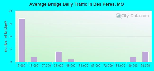
- 771,541Total average daily traffic
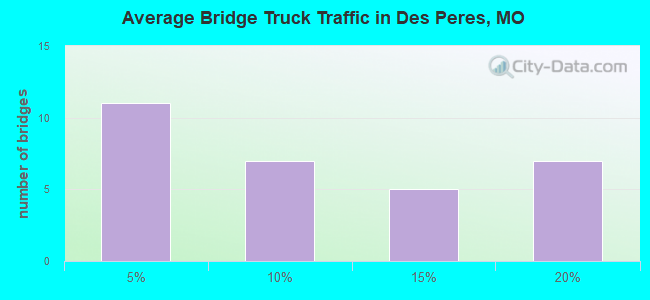
- 118,648Total average daily truck traffic
- National Bridge Inventory (NBI) Registered Bridges for Des Peres
- No street view available for this location
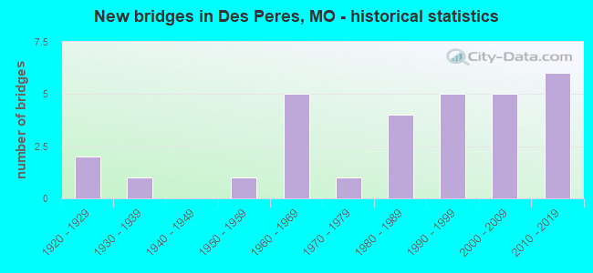
- New bridges - historical statistics
- 21920-1929
- 11930-1939
- 11950-1959
- 51960-1969
- 11970-1979
- 41980-1989
- 51990-1999
- 52000-2009
- 62010-2019
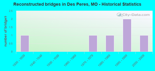
- Reconstructed bridges - Historical Statistics
- 11930-1939
- 01940-1949
- 01950-1959
- 01960-1969
- 11970-1979
- 11980-1989
- 21990-1999
- 12000-2009
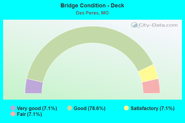
- Bridge Condition - Deck
- 7.1%Very good
- 78.6%Good
- 7.1%Satisfactory
- 7.1%Fair
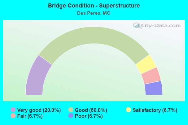
- Bridge Condition - Superstructure
- 20.0%Very good
- 60.0%Good
- 6.7%Satisfactory
- 6.7%Fair
- 6.7%Poor
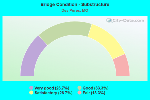
- Bridge Condition - Substructure
- 26.7%Very good
- 33.3%Good
- 26.7%Satisfactory
- 13.3%Fair
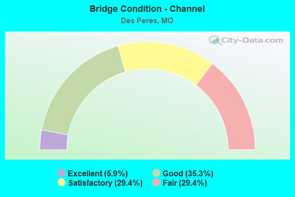
- Bridge Condition - Channel
- 5.9%Excellent
- 35.3%Good
- 29.4%Satisfactory
- 29.4%Fair
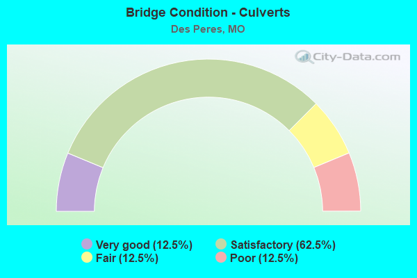
- Bridge Condition - Culverts
- 12.5%Very good
- 62.5%Satisfactory
- 12.5%Fair
- 12.5%Poor
Find on map >> Show street view
Structure Number: 15605, Location: S 32 T 45 N R 5 E (Lat: 38.592183, Lng: -90.478311), Route carried "on" structure: County highway , Year Built: 1960, Status: Posted for load, Structure Length: 1.46m (4.79ft), Average Daily Traffic: 430 (year 2020), Truck Traffic: 2%, Average Future Daily Traffic: 581 (year 2040), Features Intersected: GRAND GLAIZE CR, Facility Carried by Structure: MASON LN
Minimum Vertical Clearance: 30+ m (98+ ft), Kilometerpoint: 0.805, Lanes on structure: 2, Owner: County Highway Agency, Approaching Roadway Width: 5.8m (19.0ft), Material/Design: Steel, Design/Construction: Stringer/Multi-beam, Number Of Spans In Main Unit: 1, Length of Maximum Span: 11.6m (38.1ft), Curb or Sidewalk Widths: Left: 0.3m (1.0ft), Right: 1.2m (3.9ft), Curb-To-Curb Width: 5.7m (18.7ft), Out-to-Out Width: 7.6m (24.9ft)
Condition: Deck: Fair, Superstructure: Fair, Substructure: Fair, Channel: Fair, Operating Rating: 34.2 metric tons, Method Used To Determine Operating Rating: Allowable Stress (AS), Inventory Rating: 20.7 metric tons, Method Used To Determine Inventory Rating: Allowable Stress (AS), Structural Evaluation: Somewhat better than minimum adequacy, Deck Geometry: High priority of replacement, Waterway Adequacy: Meets minimum limits, Approach Roadway Alignment: Equal to present minimum criteria, Length Of Structure Improvement: 0.21m (0.69ft), Designated Inspection Frequency: Every 24 months, Inspection Date: March 2021, Bridge Improvement Cost: $228,000, Roadway Improvement Cost: $23,000, Total Project Cost: $341,000 ( Estimate for 2022), Deck Structure Type: Concrete Cast-file-Place, Wearing Surface/Protective System: Wearing Surface: Monolithic Concrete
Find on map >> Show street view
Structure Number: 15619, Location: S 4 T 44 N R 5 E (Lat: 38.576717, Lng: -90.464400), Route carried "on" structure: County highway , Year Built: 1935, Year Reconstructed: 1989, Status: Posted for load, Structure Length: 1.13m (3.71ft), Average Daily Traffic: 2,615 (year 2020), Truck Traffic: 2%, Average Future Daily Traffic: 3,530 (year 2040), Design Load: H 20, Features Intersected: SUGAR CR, Facility Carried by Structure: BARRETT STATION RD
Minimum Vertical Clearance: 30+ m (98+ ft), Kilometerpoint: 0.000, Lanes on structure: 2, Owner: County Highway Agency, Approaching Roadway Width: 6.4m (21.0ft), Material/Design: Prestressed concrete, Design/Construction: Box Beam or Girders - Multiple, Number Of Spans In Main Unit: 1, Length of Maximum Span: 10.7m (35.1ft), Curb-To-Curb Width: 6.4m (21.0ft), Out-to-Out Width: 6.8m (22.3ft)
Condition: Deck: Good, Superstructure: Good, Substructure: Fair, Channel: Satisfactory, Operating Rating: 89.1 metric tons, Method Used To Determine Operating Rating: Allowable Stress (AS), Inventory Rating: 80.1 metric tons, Method Used To Determine Inventory Rating: Allowable Stress (AS), Structural Evaluation: Somewhat better than minimum adequacy, Deck Geometry: High priority of replacement, Waterway Adequacy: Superior to present desirable criteria, Approach Roadway Alignment: Better than present minimum criteria, Length Of Structure Improvement: 0.18m (0.59ft), Designated Inspection Frequency: Every 24 months, Inspection Date: March 2021, Bridge Improvement Cost: $154,000, Roadway Improvement Cost: $15,000, Total Project Cost: $231,000 ( Estimate for 2022), Deck Structure Type: Other, Wearing Surface/Protective System: Wearing Surface: Bituminous, Membrane: Preformed Fabric, Deck Protection: Bituminous
Find on map >> Show street view
Structure Number: 1569, Location: S 4 T 44 N R 5 E (Lat: 38.580031, Lng: -90.454528), Route carried "on" structure: County highway , Year Built: 1991, Status: Posted for load, Structure Length: 0.94m (3.08ft), Average Daily Traffic: 28,843 (year 2020), Truck Traffic: 10%, Average Future Daily Traffic: 38,938 (year 2040), Features Intersected: DES PERES CR, Facility Carried by Structure: DOUGHERTY FERRY RD
Minimum Vertical Clearance: 30+ m (98+ ft), Kilometerpoint: 7.081, Lanes on structure: 4, Owner: County Highway Agency, Approaching Roadway Width: 23.5m (77.1ft), Material/Design: Concrete, Design/Construction: Culvert, Number Of Spans In Main Unit: 2, Length of Maximum Span: 4.5m (14.8ft)
Condition: Channel: Satisfactory, Culverts: Satisfactory, Operating Rating: 64.8 metric tons, Method Used To Determine Operating Rating: Allowable Stress (AS), Inventory Rating: 38.7 metric tons, Method Used To Determine Inventory Rating: Allowable Stress (AS), Structural Evaluation: Equal to present minimum criteria, Waterway Adequacy: Superior to present desirable criteria, Approach Roadway Alignment: Equal to present desirable criteria, Designated Inspection Frequency: Every 24 months, Inspection Date: March 2020
Find on map >> Show street view
Structure Number: 15692, Location: S 4 T 44 N R 4 E (Lat: 38.592511, Lng: -90.472283), Route carried "on" structure: County highway , Year Built: 1985, Status: Posted for load, Structure Length: 0.67m (2.20ft), Average Daily Traffic: 6,429 (year 2020), Truck Traffic: 5%, Average Future Daily Traffic: 8,679 (year 2040), Design Load: H 20, Features Intersected: TRIB GRAND GLAIZE, Facility Carried by Structure: BARRETT STATION RD
Minimum Vertical Clearance: 30+ m (98+ ft), Kilometerpoint: 0.000, Lanes on structure: 2, Owner: County Highway Agency, Approaching Roadway Width: 13.4m (44.0ft), Material/Design: Concrete continuous, Design/Construction: Culvert, Number Of Spans In Main Unit: 2, Length of Maximum Span: 3.0m (9.8ft)
Condition: Channel: Satisfactory, Culverts: Satisfactory, Operating Rating: 45.0 metric tons, Method Used To Determine Operating Rating: Allowable Stress (AS), Inventory Rating: 26.1 metric tons, Method Used To Determine Inventory Rating: Allowable Stress (AS), Structural Evaluation: Equal to present minimum criteria, Waterway Adequacy: Equal to present desirable criteria, Approach Roadway Alignment: Equal to present desirable criteria, Designated Inspection Frequency: Every 24 months, Inspection Date: March 2021
Find on map >> Show street view
Structure Number: 16249, Location: S 4 T 44 N R 5 E (Lat: 38.579492, Lng: -90.454358), Route carried "on" structure: City street , Year Built: 1993, Status: Open, Structure Length: 1.40m (4.59ft), Average Daily Traffic: 750 (year 2020), Truck Traffic: 2%, Average Future Daily Traffic: 1,013 (year 2040), Design Load: HS 20+Mod, Features Intersected: SUGAR CR, Facility Carried by Structure: OLD DOUGHERTY F RD
Minimum Vertical Clearance: 30+ m (98+ ft), Kilometerpoint: 0.161, Lanes on structure: 2, Owner: City or Municipal Highway Agency, Approaching Roadway Width: 6.1m (20.0ft), Skew: 4 degrees, Material/Design: Concrete, Design/Construction: Culvert, Number Of Spans In Main Unit: 3, Length of Maximum Span: 4.6m (15.1ft), Curb or Sidewalk Widths: Left: 1.2m (3.9ft), Right: 0.0m
Condition: Channel: Fair, Culverts: Satisfactory, Operating Rating: 54.0 metric tons, Method Used To Determine Operating Rating: Field evaluation and documented engineering judgment, Inventory Rating: 32.4 metric tons, Method Used To Determine Inventory Rating: Field evaluation and documented engineering judgment, Structural Evaluation: Equal to present minimum criteria, Waterway Adequacy: Equal to present desirable criteria, Approach Roadway Alignment: Equal to present minimum criteria, Designated Inspection Frequency: Every 24 months, Inspection Date: January 2022
Find on map >> Show street view
Structure Number: 1625, Location: S 27 T 18 N R 12 E (Lat: 36.171147, Lng: -89.753400), Route carried "on" structure: State highway U, Year Built: 1971, Year Reconstructed: 1984, Status: Open, Structure Length: 7.44m (24.41ft), Average Daily Traffic: 4,561 (year 2021), Truck Traffic: 11%, Average Future Daily Traffic: 6,842 (year 2041), Design Load: H 20, Features Intersected: IS 55
Minimum Vertical Clearance: 30+ m (98+ ft), Kilometerpoint: 0.304, Lanes on structure: 2, Lanes under structure: 4, Owner: State Highway Agency, Approaching Roadway Width: 12.2m (40.0ft), Material/Design: Steel continuous, Design/Construction: Stringer/Multi-beam, Number Of Spans In Main Unit: 2, Number Of Approach Spans: 2, Length of Maximum Span: 26.2m (86.0ft), Curb-To-Curb Width: 13.4m (44.0ft), Out-to-Out Width: 14.2m (46.6ft)
Condition: Deck: Good, Superstructure: Poor, Substructure: Satisfactory, Operating Rating: 36.9 metric tons, Method Used To Determine Operating Rating: Load Factor (LF), Inventory Rating: 22.5 metric tons, Method Used To Determine Inventory Rating: Load Factor (LF), Structural Evaluation: Meets minimum limits, Deck Geometry: Better than present minimum criteria, Underclear: Equal to present minimum criteria, Approach Roadway Alignment: Equal to present minimum criteria, Length Of Structure Improvement: 0.85m (2.79ft), Designated Inspection Frequency: Every 24 months, Other Special Inspection Frequency: Every 24 months, Inspection Date: January 2022, Other Special Inspection Date: January 2022, Bridge Improvement Cost: $728,000, Roadway Improvement Cost: $73,000, Total Project Cost: $1,093,000 ( Estimate for 2022), Deck Structure Type: Concrete Cast-file-Place, Wearing Surface/Protective System: Wearing Surface: Low Slump Concrete
Find on map >> Show street view
Structure Number: 1625, Location: S 4 T 44 N R 5 E (Lat: 38.582042, Lng: -90.453478), Route carried "on" structure: City street , Year Built: 1995, Status: Open, Structure Length: 1.37m (4.49ft), Average Daily Traffic: 10,000 (year 2020), Truck Traffic: 1%, Average Future Daily Traffic: 13,500 (year 2040), Design Load: HS 20, Features Intersected: TRIB GRAND GLAIZE, Facility Carried by Structure: DES PERES RD
Minimum Vertical Clearance: 30+ m (98+ ft), Kilometerpoint: 0.000, Lanes on structure: 2, Owner: City or Municipal Highway Agency, Approaching Roadway Width: 9.1m (29.9ft), Material/Design: Concrete, Design/Construction: Culvert, Number Of Spans In Main Unit: 3, Length of Maximum Span: 4.3m (14.1ft)
Condition: Channel: Fair, Culverts: Satisfactory, Operating Rating: 54.0 metric tons, Method Used To Determine Operating Rating: Load Factor (LF), Inventory Rating: 32.4 metric tons, Method Used To Determine Inventory Rating: Load Factor (LF), Structural Evaluation: Equal to present minimum criteria, Waterway Adequacy: Equal to present desirable criteria, Approach Roadway Alignment: Equal to present desirable criteria, Designated Inspection Frequency: Every 24 months, Inspection Date: January 2022
Find on map >> Show street view
Structure Number: 31252, Location: S 9 T 44 N R 5 E (Lat: 38.571842, Lng: -90.459375), Route carried "on" structure: County highway 141, Year Built: 2004, Status: Posted for load, Structure Length: 3.54m (11.61ft), Average Daily Traffic: 1,435 (year 2020), Truck Traffic: 5%, Average Future Daily Traffic: 1,937 (year 2040), Design Load: HS 25 or greater, Features Intersected: UP RR, Facility Carried by Structure: BARRETT STATION RD
Minimum Vertical Clearance: 30+ m (98+ ft), Kilometerpoint: 0.000, Lanes on structure: 2, Owner: County Highway Agency, Approaching Roadway Width: 11.6m (38.1ft), Skew: 2 degrees, Material/Design: Steel, Design/Construction: Stringer/Multi-beam, Number Of Spans In Main Unit: 1, Length of Maximum Span: 34.1m (111.9ft), Curb or Sidewalk Widths: Left: 1.5m (4.9ft), Right: 1.5m (4.9ft), Curb-To-Curb Width: 14.0m (45.9ft), Out-to-Out Width: 14.8m (48.6ft)
Condition: Deck: Good, Superstructure: Very good, Substructure: Good, Inventory Rating: 71.1 metric tons, Method Used To Determine Inventory Rating: Load Factor (LF), Structural Evaluation: Better than present minimum criteria, Deck Geometry: Superior to present desirable criteria, Underclear: Better than present minimum criteria, Approach Roadway Alignment: Equal to present desirable criteria, Designated Inspection Frequency: Every 24 months, Inspection Date: March 2021, Deck Structure Type: Concrete Cast-file-Place, Wearing Surface/Protective System: Wearing Surface: Monolithic Concrete, Membrane: Other, Deck Protection: Epoxy Coated Reinforcing
Find on map >> Show street view
Structure Number: 31842, Location: S 3 T 44 N R 5 E (Lat: 38.581625, Lng: -90.447942), Route carried "on" structure: City street , Year Built: 2007, Status: Open, Structure Length: 8.30m (27.23ft), Average Daily Traffic: 32,824 (year 2021), Truck Traffic: 5%, Average Future Daily Traffic: 45,954 (year 2041), Features Intersected: IS 270, Facility Carried by Structure: DOUGHERTY FERRY RD
Minimum Vertical Clearance: 5.23m (17.16ft), Kilometerpoint: 4.197, Lanes on structure: 7, Lanes under structure: 9, Owner: State Highway Agency, Approaching Roadway Width: 27.7m (90.9ft), Material/Design: Prestressed concrete continuous, Design/Construction: Box Beam or Girders - Multiple, Number Of Spans In Main Unit: 4, Length of Maximum Span: 22.9m (75.1ft), Curb-To-Curb Width: 26.9m (88.3ft), Out-to-Out Width: 29.9m (98.1ft)
Condition: Deck: Good, Superstructure: Good, Substructure: Good, Operating Rating: 63.0 metric tons, Method Used To Determine Operating Rating: Load Factor (LF), Inventory Rating: 37.8 metric tons, Method Used To Determine Inventory Rating: Load Factor (LF), Structural Evaluation: Better than present minimum criteria, Deck Geometry: Somewhat better than minimum adequacy, Underclear: High priority of corrective action, Approach Roadway Alignment: Equal to present desirable criteria, Designated Inspection Frequency: Every 24 months, Inspection Date: June 2020, Deck Structure Type: Concrete Cast-file-Place, Wearing Surface/Protective System: Wearing Surface: Monolithic Concrete, Deck Protection: Epoxy Coated Reinforcing
Find on map >> Show street view
Structure Number: 32685, Location: S 26 T 45 N R 5 E (Lat: 38.604317, Lng: -90.429272), Route carried "on" structure: City street , Year Built: 2009, Status: Open, Structure Length: 0.79m (2.59ft), Average Daily Traffic: 2,000 (year 2020), Truck Traffic: 3%, Average Future Daily Traffic: 2,700 (year 2040), Design Load: HS 20, Features Intersected: TWO MILE CR, Facility Carried by Structure: BROOKBEND DR
Minimum Vertical Clearance: 30+ m (98+ ft), Kilometerpoint: 0.209, Lanes on structure: 2, Owner: City or Municipal Highway Agency, Approaching Roadway Width: 7.0m (23.0ft), Material/Design: Concrete, Design/Construction: Arch - Deck, Number Of Spans In Main Unit: 1, Length of Maximum Span: 7.3m (24.0ft), Curb-To-Curb Width: 9.1m (29.9ft), Out-to-Out Width: 9.8m (32.2ft)
Condition: Superstructure: Good, Substructure: Very good, Channel: Satisfactory, Operating Rating: 54.0 metric tons, Method Used To Determine Operating Rating: Load Factor (LF), Inventory Rating: 32.4 metric tons, Method Used To Determine Inventory Rating: Load Factor (LF), Structural Evaluation: Better than present minimum criteria, Deck Geometry: Somewhat better than minimum adequacy, Waterway Adequacy: Superior to present desirable criteria, Approach Roadway Alignment: Equal to present desirable criteria, Designated Inspection Frequency: Every 24 months, Inspection Date: January 2022
Find on map >> Show street view
Structure Number: 33422, Location: S 26 T 45 N R 5 E (Lat: 38.615050, Lng: -90.427675), Route carried "on" structure: City street , Year Built: 2011, Status: Open, Structure Length: 1.71m (5.61ft), Average Daily Traffic: 400 (year 2020), Truck Traffic: 3%, Average Future Daily Traffic: 540 (year 2040), Design Load: HS 20, Features Intersected: TRIB OF TWO MILE C, Facility Carried by Structure: FIRETHORN DR
Minimum Vertical Clearance: 30+ m (98+ ft), Kilometerpoint: 0.455, Lanes on structure: 2, Owner: City or Municipal Highway Agency, Approaching Roadway Width: 7.9m (25.9ft), Material/Design: Prestressed concrete, Design/Construction: Box Beam or Girders - Multiple, Number Of Spans In Main Unit: 1, Length of Maximum Span: 16.2m (53.1ft), Curb or Sidewalk Widths: Left: 0.0m, Right: 1.5m (4.9ft), Curb-To-Curb Width: 8.8m (28.9ft), Out-to-Out Width: 9.4m (30.8ft)
Condition: Deck: Good, Superstructure: Good, Substructure: Good, Channel: Excellent, Operating Rating: 60.3 metric tons, Method Used To Determine Operating Rating: Load and Resistance Factor (LRFR), Inventory Rating: 36.0 metric tons, Method Used To Determine Inventory Rating: Load and Resistance Factor (LRFR), Structural Evaluation: Better than present minimum criteria, Deck Geometry: Equal to present minimum criteria, Waterway Adequacy: Superior to present desirable criteria, Approach Roadway Alignment: Equal to present desirable criteria, Designated Inspection Frequency: Every 24 months, Inspection Date: January 2022, Deck Structure Type: Concrete Precast Panels, Wearing Surface/Protective System: Wearing Surface: Bituminous
Find on map >> Show street view
Structure Number: 34048, Location: S 3 T 44 N R 5 E (Lat: 38.578828, Lng: -90.448783), Route carried "on" structure: City street , Year Built: 2012, Status: Open, Structure Length: 2.74m (8.99ft), Average Daily Traffic: 800 (year 2020), Truck Traffic: 2%, Average Future Daily Traffic: 1,080 (year 2040), Features Intersected: SUGAR CR, Facility Carried by Structure: HIGHLAND AVE
Minimum Vertical Clearance: 30+ m (98+ ft), Kilometerpoint: 0.000, Lanes on structure: 2, Owner: City or Municipal Highway Agency, Approaching Roadway Width: 7.9m (25.9ft), Skew: 3 degrees, Material/Design: Prestressed concrete, Design/Construction: Tee Beam, Number Of Spans In Main Unit: 1, Length of Maximum Span: 24.7m (81.0ft), Curb or Sidewalk Widths: Left: 0.4m (1.3ft), Right: 0.4m (1.3ft), Curb-To-Curb Width: 9.8m (32.2ft), Out-to-Out Width: 10.4m (34.1ft)
Condition: Deck: Good, Superstructure: Good, Substructure: Very good, Channel: Good, Operating Rating: 59.4 metric tons, Method Used To Determine Operating Rating: Load Factor (LF), Inventory Rating: 36.0 metric tons, Method Used To Determine Inventory Rating: Load Factor (LF), Structural Evaluation: Better than present minimum criteria, Deck Geometry: Equal to present minimum criteria, Waterway Adequacy: Equal to present desirable criteria, Approach Roadway Alignment: Somewhat better than minimum adequacy, Designated Inspection Frequency: Every 24 months, Inspection Date: January 2022, Deck Structure Type: Concrete Cast-file-Place, Wearing Surface/Protective System: Wearing Surface: Monolithic Concrete
Find on map >> Show street view
Structure Number: 34147, Location: S 32 T 45 N R 5 E (Lat: 38.595283, Lng: -90.473419), Route carried "on" structure: County highway , Year Built: 2010, Status: Posted for load, Structure Length: 0.73m (2.40ft), Average Daily Traffic: 12,800 (year 2020), Truck Traffic: 3%, Average Future Daily Traffic: 17,280 (year 2040), Design Load: HS 25 or greater, Features Intersected: ROYAL ACRES CR, Facility Carried by Structure: BARRETT STATION RD
Minimum Vertical Clearance: 30+ m (98+ ft), Kilometerpoint: 0.000, Lanes on structure: 4, Owner: County Highway Agency, Approaching Roadway Width: 15.2m (49.9ft), Skew: 3 degrees, Material/Design: Concrete, Design/Construction: Culvert, Number Of Spans In Main Unit: 2, Length of Maximum Span: 3.0m (9.8ft)
Condition: Channel: Good, Culverts: Very good, Operating Rating: 78.3 metric tons, Method Used To Determine Operating Rating: Load Factor (LF), Inventory Rating: 46.8 metric tons, Method Used To Determine Inventory Rating: Load Factor (LF), Structural Evaluation: Equal to present desirable criteria, Waterway Adequacy: Equal to present desirable criteria, Approach Roadway Alignment: Equal to present desirable criteria, Designated Inspection Frequency: Every 24 months, Inspection Date: March 2021
Find on map >> Show street view
Structure Number: 34701, Location: S 26 T 45 N R 5 E (Lat: 38.610556, Lng: -90.429444), Route carried "on" structure: City street , Year Built: 2014, Status: Open, Structure Length: 1.13m (3.71ft), Average Daily Traffic: 950 (year 2020), Truck Traffic: 1%, Average Future Daily Traffic: 1,520 (year 2040), Design Load: HS 20, Features Intersected: TWO MILE CR, Facility Carried by Structure: CLAYCHESTER DR
Minimum Vertical Clearance: 30+ m (98+ ft), Kilometerpoint: 0.000, Lanes on structure: 2, Owner: City or Municipal Highway Agency, Approaching Roadway Width: 6.1m (20.0ft), Material/Design: Prestressed concrete, Design/Construction: Slab, Number Of Spans In Main Unit: 1, Length of Maximum Span: 10.4m (34.1ft), Curb-To-Curb Width: 9.4m (30.8ft), Out-to-Out Width: 10.1m (33.1ft)
Condition: Deck: Good, Superstructure: Very good, Substructure: Good, Channel: Satisfactory, Operating Rating: 88.2 metric tons, Method Used To Determine Operating Rating: Load Factor (LF), Inventory Rating: 68.4 metric tons, Method Used To Determine Inventory Rating: Load Factor (LF), Structural Evaluation: Better than present minimum criteria, Deck Geometry: Equal to present minimum criteria, Waterway Adequacy: Superior to present desirable criteria, Approach Roadway Alignment: Equal to present desirable criteria, Designated Inspection Frequency: Every 24 months, Inspection Date: January 2022, Deck Structure Type: Concrete Cast-file-Place, Wearing Surface/Protective System: Wearing Surface: Monolithic Concrete, Deck Protection: Epoxy Coated Reinforcing
Find on map >> Show street view
Structure Number: 34997, Location: S 26 T 45 N R 5 E (Lat: 38.613806, Lng: -90.428333), Route carried "on" structure: City street , Year Built: 2015, Status: Open, Structure Length: 1.72m (5.64ft), Average Daily Traffic: 300 (year 2020), Truck Traffic: 5%, Average Future Daily Traffic: 405 (year 2040), Design Load: HS 20, Features Intersected: TWO MILE CR, Facility Carried by Structure: FAWN VALLEY DR
Minimum Vertical Clearance: 30+ m (98+ ft), Kilometerpoint: 0.644, Lanes on structure: 2, Owner: City or Municipal Highway Agency, Approaching Roadway Width: 7.9m (25.9ft), Material/Design: Prestressed concrete, Design/Construction: Box Beam or Girders - Multiple, Number Of Spans In Main Unit: 1, Length of Maximum Span: 16.5m (54.1ft), Curb-To-Curb Width: 8.5m (27.9ft), Out-to-Out Width: 9.1m (29.9ft)
Condition: Deck: Good, Superstructure: Very good, Substructure: Very good, Channel: Good, Operating Rating: 72.0 metric tons, Method Used To Determine Operating Rating: Load Factor (LF), Inventory Rating: 43.2 metric tons, Method Used To Determine Inventory Rating: Load Factor (LF), Structural Evaluation: Equal to present desirable criteria, Deck Geometry: Equal to present minimum criteria, Waterway Adequacy: Superior to present desirable criteria, Approach Roadway Alignment: Equal to present desirable criteria, Designated Inspection Frequency: Every 24 months, Inspection Date: January 2022, Deck Structure Type: Concrete Cast-file-Place, Wearing Surface/Protective System: Wearing Surface: Monolithic Concrete, Deck Protection: Epoxy Coated Reinforcing
Find on map >> Show street view
Structure Number: 35674, Location: S 26 T 45 N R 8 E (Lat: 38.616667, Lng: -90.431389), Route carried "on" structure: City street , Year Built: 2018, Status: Open, Structure Length: 1.46m (4.79ft), Average Daily Traffic: 160 (year 2020), Truck Traffic: 5%, Average Future Daily Traffic: 216 (year 2040), Design Load: HS 20, Features Intersected: TWO MILE CR, Facility Carried by Structure: OAK DR
Minimum Vertical Clearance: 30+ m (98+ ft), Kilometerpoint: 0.644, Lanes on structure: 2, Owner: City or Municipal Highway Agency, Approaching Roadway Width: 9.1m (29.9ft), Material/Design: Concrete continuous, Design/Construction: Slab, Number Of Spans In Main Unit: 2, Length of Maximum Span: 7.3m (24.0ft), Curb-To-Curb Width: 9.1m (29.9ft), Out-to-Out Width: 9.8m (32.2ft)
Condition: Deck: Good, Superstructure: Good, Substructure: Very good, Channel: Good, Operating Rating: 82.8 metric tons, Method Used To Determine Operating Rating: Load Factor (LF), Inventory Rating: 63.0 metric tons, Method Used To Determine Inventory Rating: Load Factor (LF), Structural Evaluation: Better than present minimum criteria, Deck Geometry: Equal to present minimum criteria, Waterway Adequacy: Equal to present desirable criteria, Approach Roadway Alignment: Equal to present minimum criteria, Designated Inspection Frequency: Every 24 months, Inspection Date: January 2022, Deck Structure Type: Concrete Cast-file-Place, Wearing Surface/Protective System: Wearing Surface: Monolithic Concrete, Deck Protection: Epoxy Coated Reinforcing
Find on map >> Show street view
Structure Number: 3945, Location: S 27 T 45 N R 5 E (Lat: 38.605850, Lng: -90.450883), Route carried "on" structure: County highway , Year Built: 1989, Status: Open, Structure Length: 9.94m (32.61ft), Average Daily Traffic: 3,900 (year 2021), Truck Traffic: 5%, Average Future Daily Traffic: 5,850 (year 2041), Design Load: HS 20+Mod, Features Intersected: IS 270, RP IS270W TO MO1, Facility Carried by Structure: JJ KELLEY MEMORIAL
Minimum Vertical Clearance: 30+ m (98+ ft), Kilometerpoint: 0.261, Lanes on structure: 3, Lanes under structure: 12, Owner: State Highway Agency, Approaching Roadway Width: 15.8m (51.8ft), Skew: 1 degrees, Material/Design: Steel continuous, Design/Construction: Stringer/Multi-beam, Number Of Spans In Main Unit: 2, Length of Maximum Span: 51.6m (169.3ft), Curb or Sidewalk Widths: Left: 0.2m (0.7ft), Right: 1.7m (5.6ft), Curb-To-Curb Width: 15.8m (51.8ft), Out-to-Out Width: 18.2m (59.7ft)
Condition: Deck: Satisfactory, Superstructure: Satisfactory, Substructure: Satisfactory, Operating Rating: 71.1 metric tons, Method Used To Determine Operating Rating: Load Factor (LF), Inventory Rating: 30.6 metric tons, Method Used To Determine Inventory Rating: Load Factor (LF), Structural Evaluation: Equal to present minimum criteria, Deck Geometry: Better than present minimum criteria, Underclear: Equal to present minimum criteria, Approach Roadway Alignment: Equal to present minimum criteria, Designated Inspection Frequency: Every 24 months, Inspection Date: June 2020, Deck Structure Type: Concrete Cast-file-Place, Wearing Surface/Protective System: Wearing Surface: Monolithic Concrete, Deck Protection: Epoxy Coated Reinforcing
Find on map >> Show street view
Structure Number: 405, Location: S 20 T 36 N R 6 E (Lat: 37.809678, Lng: -90.389819), Route carried "on" structure: State highway EE, Year Built: 1959, Status: Open, Structure Length: 0.76m (2.49ft), Average Daily Traffic: 1,966 (year 2021), Truck Traffic: 2%, Average Future Daily Traffic: 3,146 (year 2041), Design Load: H 15, Features Intersected: CAMP CR
Minimum Vertical Clearance: 30+ m (98+ ft), Kilometerpoint: 14.734, Lanes on structure: 2, Owner: State Highway Agency, Approaching Roadway Width: 7.3m (24.0ft), Material/Design: Concrete continuous, Design/Construction: Culvert, Number Of Spans In Main Unit: 2, Length of Maximum Span: 3.7m (12.1ft), Curb-To-Curb Width: 8.2m (26.9ft), Out-to-Out Width: 8.8m (28.9ft)
Condition: Channel: Good, Culverts: Satisfactory, Operating Rating: 66.6 metric tons, Method Used To Determine Operating Rating: Load Factor (LF), Inventory Rating: 40.5 metric tons, Method Used To Determine Inventory Rating: Load Factor (LF), Structural Evaluation: Equal to present minimum criteria, Deck Geometry: Meets minimum limits, Waterway Adequacy: Equal to present desirable criteria, Approach Roadway Alignment: Equal to present desirable criteria, Designated Inspection Frequency: Every 24 months, Inspection Date: March 2021
Find on map >> Show street view
Structure Number: 405, Location: S 33 T 45 N R 5 E (Lat: 38.601481, Lng: -90.455239), Route carried "on" structure: State highway 100, Year Built: 1995, Status: Open, Structure Length: 3.38m (11.09ft), Average Daily Traffic: 27,252 (year 2021), Truck Traffic: 13%, Average Future Daily Traffic: 38,153 (year 2041), Design Load: HS 20+Mod, Features Intersected: CST DES PERES RD
Minimum Vertical Clearance: 30+ m (98+ ft), Kilometerpoint: 171.090, Lanes on structure: 5, Lanes under structure: 3, Base Highway Network: Yes, Owner: State Highway Agency, Approaching Roadway Width: 24.4m (80.1ft), Skew: 30 degrees, Material/Design: Prestressed concrete continuous, Design/Construction: Stringer/Multi-beam, Number Of Spans In Main Unit: 2, Length of Maximum Span: 21.9m (71.9ft), Curb or Sidewalk Widths: Left: 0.2m (0.7ft), Right: 0.2m (0.7ft), Curb-To-Curb Width: 23.6m (77.4ft), Out-to-Out Width: 24.4m (80.1ft)
Condition: Deck: Good, Superstructure: Good, Substructure: Good, Operating Rating: 82.8 metric tons, Method Used To Determine Operating Rating: Load Factor (LF), Inventory Rating: 50.4 metric tons, Method Used To Determine Inventory Rating: Load Factor (LF), Structural Evaluation: Better than present minimum criteria, Deck Geometry: Better than present minimum criteria, Underclear: Somewhat better than minimum adequacy, Approach Roadway Alignment: Equal to present desirable criteria, Designated Inspection Frequency: Every 24 months, Inspection Date: June 2020, Deck Structure Type: Concrete Cast-file-Place, Wearing Surface/Protective System: Wearing Surface: Monolithic Concrete, Deck Protection: Epoxy Coated Reinforcing
Find on map >> Show street view
Structure Number: 4452, Location: S 32 T 45 N R 5 E (Lat: 38.596414, Lng: -90.476122), Route carried "on" structure: State highway 100, Year Built: 1920, Year Reconstructed: 1999, Status: Open, Structure Length: 0.91m (2.99ft), Average Daily Traffic: 40,016 (year 2021), Truck Traffic: 13%, Average Future Daily Traffic: 56,022 (year 2041), Design Load: H 20, Features Intersected: BR GRAND GLAIZE CR
Minimum Vertical Clearance: 30+ m (98+ ft), Kilometerpoint: 169.017, Lanes on structure: 6, Base Highway Network: Yes, Owner: State Highway Agency, Approaching Roadway Width: 27.4m (89.9ft), Material/Design: Concrete continuous, Design/Construction: Culvert, Number Of Spans In Main Unit: 3, Length of Maximum Span: 2.8m (9.2ft)
Condition: Channel: Fair, Culverts: Fair, Operating Rating: 38.7 metric tons, Method Used To Determine Operating Rating: Load Factor (LF), Inventory Rating: 23.4 metric tons, Method Used To Determine Inventory Rating: Load Factor (LF), Structural Evaluation: Somewhat better than minimum adequacy, Waterway Adequacy: Equal to present minimum criteria, Approach Roadway Alignment: Equal to present desirable criteria, Designated Inspection Frequency: Every 24 months, Underwater Inspection Frequency: Every 60 months, Inspection Date: November 2021, Underwater Inspection Date: November 2021
Find on map >> Show street view
Structure Number: 4664, Location: S 6 T 41 N R 6 E (Lat: 38.322483, Lng: -90.399222), Route carried "on" structure: US 61, Year Built: 1923, Year Reconstructed: 1935, Status: Open, Structure Length: 0.88m (2.89ft), Average Daily Traffic: 5,978 (year 2021), Truck Traffic: 7%, Average Future Daily Traffic: 10,163 (year 2041), Design Load: H 15, Features Intersected: BRAUHN CR
Minimum Vertical Clearance: 30+ m (98+ ft), Kilometerpoint: 307.516, Lanes on structure: 4, Owner: State Highway Agency, Approaching Roadway Width: 29.3m (96.1ft), Skew: 4 degrees, Material/Design: Concrete continuous, Design/Construction: Culvert, Number Of Spans In Main Unit: 2, Length of Maximum Span: 3.0m (9.8ft)
Condition: Channel: Fair, Culverts: Poor, Operating Rating: 42.3 metric tons, Method Used To Determine Operating Rating: Load Factor (LF), Inventory Rating: 25.2 metric tons, Method Used To Determine Inventory Rating: Load Factor (LF), Structural Evaluation: Meets minimum limits, Waterway Adequacy: Equal to present desirable criteria, Approach Roadway Alignment: Equal to present desirable criteria, Length Of Structure Improvement: 0.15m (0.49ft), Designated Inspection Frequency: Every 24 months, Inspection Date: December 2020, Bridge Improvement Cost: $250,000, Roadway Improvement Cost: $25,000, Total Project Cost: $375,000 ( Estimate for 2022)
Find on map >> Show street view
Structure Number: 711, Location: S 34 T 45 N R 5 E (Lat: 38.602639, Lng: -90.450522), Route carried "on" structure: State highway 100, Year Built: 1962, Year Reconstructed: 2000, Status: Open, Structure Length: 9.08m (29.79ft), Average Daily Traffic: 27,252 (year 2021), Truck Traffic: 13%, Average Future Daily Traffic: 38,153 (year 2041), Design Load: HS 20, Features Intersected: IS 270, RP MO100E TO IS2
Minimum Vertical Clearance: 30+ m (98+ ft), Kilometerpoint: 171.487, Lanes on structure: 5, Lanes under structure: 9, Base Highway Network: Yes, Owner: State Highway Agency, Approaching Roadway Width: 26.8m (87.9ft), Skew: 31 degrees, Material/Design: Steel continuous, Design/Construction: Stringer/Multi-beam, Number Of Spans In Main Unit: 4, Length of Maximum Span: 25.3m (83.0ft), Curb-To-Curb Width: 26.6m (87.3ft), Out-to-Out Width: 29.3m (96.1ft)
Condition: Deck: Good, Superstructure: Good, Substructure: Satisfactory, Operating Rating: 59.4 metric tons, Method Used To Determine Operating Rating: Load Factor (LF), Inventory Rating: 36.0 metric tons, Method Used To Determine Inventory Rating: Load Factor (LF), Structural Evaluation: Equal to present minimum criteria, Deck Geometry: Superior to present desirable criteria, Underclear: Meets minimum limits, Approach Roadway Alignment: Equal to present desirable criteria, Designated Inspection Frequency: Every 24 months, Inspection Date: June 2020, Deck Structure Type: Concrete Cast-file-Place, Wearing Surface/Protective System: Wearing Surface: Monolithic Concrete, Deck Protection: Epoxy Coated Reinforcing
Find on map >> Show street view
Structure Number: 807, Location: S 33 T 30 N R 33 W (Lat: 37.304775, Lng: -94.572139), Route carried "on" structure: State highway M, Year Built: 1960, Year Reconstructed: 2004, Status: Open, Structure Length: 3.81m (12.50ft), Average Daily Traffic: 511 (year 2021), Truck Traffic: 16%, Average Future Daily Traffic: 767 (year 2041), Design Load: H 15, Features Intersected: BLACKBERRY CR
Minimum Vertical Clearance: 30+ m (98+ ft), Kilometerpoint: 3.468, Lanes on structure: 2, Owner: State Highway Agency, Approaching Roadway Width: 6.1m (20.0ft), Material/Design: Steel, Design/Construction: Stringer/Multi-beam, Number Of Spans In Main Unit: 3, Length of Maximum Span: 12.8m (42.0ft), Curb-To-Curb Width: 7.4m (24.3ft), Out-to-Out Width: 7.8m (25.6ft)
Condition: Deck: Very good, Superstructure: Good, Substructure: Satisfactory, Channel: Good, Operating Rating: 66.6 metric tons, Method Used To Determine Operating Rating: Load Factor (LF), Inventory Rating: 40.5 metric tons, Method Used To Determine Inventory Rating: Load Factor (LF), Structural Evaluation: Equal to present minimum criteria, Deck Geometry: Meets minimum limits, Waterway Adequacy: Equal to present desirable criteria, Approach Roadway Alignment: Equal to present desirable criteria, Designated Inspection Frequency: Every 24 months, Inspection Date: July 2021, Deck Structure Type: Concrete Cast-file-Place, Wearing Surface/Protective System: Wearing Surface: Monolithic Concrete, Deck Protection: Epoxy Coated Reinforcing
Find on map >> Show street view
Structure Number: 31842, Location: S 3 T 44 N R 5 E (Lat: 38.581625, Lng: -90.447942), Route carried "under" structure: Interstate 270, Year Built: 2007, Structure Length: 0. m, Average Daily Traffic: 94,370 (year 2021), Truck Traffic: 18%, Features Intersected: IS 270, Facility Carried by Structure: DOUGHERTY FERRY RD
Minimum Vertical Clearance: 5.21m (17.09ft), Kilometerpoint: 43.539, Lanes on structure: 7, Lanes under structure: 4, Material/Design: Prestressed concrete continuous, Design/Construction: Box Beam or Girders - Multiple, Length of Maximum Span: 22.9m (75.1ft)
Find on map >> Show street view
Structure Number: 31842, Location: S 3 T 44 N R 5 E (Lat: 38.581625, Lng: -90.447942), Route carried "under" structure: Interstate 270, Year Built: 2007, Structure Length: 0. m, Average Daily Traffic: 93,358 (year 2021), Truck Traffic: 18%, Features Intersected: IS 270, Facility Carried by Structure: DOUGHERTY FERRY RD
Minimum Vertical Clearance: 5.18m (16.99ft), Kilometerpoint: 14.048, Lanes on structure: 7, Lanes under structure: 5, Material/Design: Prestressed concrete continuous, Design/Construction: Box Beam or Girders - Multiple, Length of Maximum Span: 22.9m (75.1ft)
Find on map >> Show street view
Structure Number: 3945, Location: S 27 T 45 N R 5 E (Lat: 38.605850, Lng: -90.450883), Route carried "under" structure: Interstate 270, Year Built: 1989, Structure Length: 0. m, Average Daily Traffic: 89,121 (year 2021), Truck Traffic: 18%, Features Intersected: IS 270, Facility Carried by Structure: JJ KELLEY MEMORIAL
Minimum Vertical Clearance: 5.18m (16.99ft), Kilometerpoint: 40.831, Lanes on structure: 3, Lanes under structure: 5, Material/Design: Steel continuous, Design/Construction: Stringer/Multi-beam, Length of Maximum Span: 51.6m (169.3ft)
Find on map >> Show street view
Structure Number: 3945, Location: S 27 T 45 N R 5 E (Lat: 38.605850, Lng: -90.450883), Route carried "under" structure: Interstate 270, Year Built: 1989, Structure Length: 0. m, Average Daily Traffic: 92,845 (year 2021), Truck Traffic: 18%, Features Intersected: IS 270, Facility Carried by Structure: JJ KELLEY MEMORIAL
Minimum Vertical Clearance: 5.03m (16.50ft), Kilometerpoint: 16.800, Lanes on structure: 3, Lanes under structure: 6, Material/Design: Steel continuous, Design/Construction: Stringer/Multi-beam, Length of Maximum Span: 51.6m (169.3ft)
Find on map >> Show street view
Structure Number: 405, Location: S 33 T 45 N R 5 E (Lat: 38.601481, Lng: -90.455239), Route carried "under" structure: City street , Year Built: 1995, Structure Length: 0. m, Average Daily Traffic: 7,674 (year 2021), Truck Traffic: 3%, Features Intersected: CST DES PERES RD, Facility Carried by Structure: MO 100 E
Minimum Vertical Clearance: 5.03m (16.50ft), Kilometerpoint: 2.932, Lanes on structure: 5, Lanes under structure: 3, Material/Design: Prestressed concrete continuous, Design/Construction: Stringer/Multi-beam, Length of Maximum Span: 21.9m (71.9ft)
Find on map >> Show street view
Structure Number: 711, Location: S 34 T 45 N R 5 E (Lat: 38.602639, Lng: -90.450522), Route carried "under" structure: Interstate 270, Year Built: 1962, Structure Length: 0. m, Average Daily Traffic: 94,370 (year 2021), Truck Traffic: 18%, Features Intersected: IS 270, Facility Carried by Structure: MO 100 E
Minimum Vertical Clearance: 4.85m (15.91ft), Kilometerpoint: 41.203, Lanes on structure: 5, Lanes under structure: 4, Material/Design: Steel continuous, Design/Construction: Stringer/Multi-beam, Length of Maximum Span: 25.3m (83.0ft)
Find on map >> Show street view
Structure Number: 711, Location: S 34 T 45 N R 5 E (Lat: 38.602639, Lng: -90.450522), Route carried "under" structure: Interstate 270, Year Built: 1962, Structure Length: 0. m, Average Daily Traffic: 87,631 (year 2021), Truck Traffic: 18%, Features Intersected: IS 270, Facility Carried by Structure: MO 100 E
Minimum Vertical Clearance: 4.93m (16.17ft), Kilometerpoint: 16.390, Lanes on structure: 5, Lanes under structure: 4, Material/Design: Steel continuous, Design/Construction: Stringer/Multi-beam, Length of Maximum Span: 25.3m (83.0ft)