Bridge Statistics for Detroit, Michigan (MI)
Condition, Traffic, Stress, Structural Evaluation, Project Costs
- National Bridge Inventory (NBI) Statistics
- 1,085Number of bridges
- 12,034ft / 3,668mTotal length
- $82,595,000Total costs
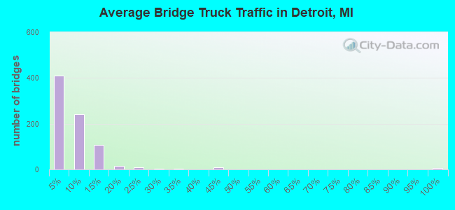
- 55,047,582Total average daily traffic
- 3,107,918Total average daily truck traffic
- National Bridge Inventory (NBI) Registered Bridges for Detroit
- No street view available for this location
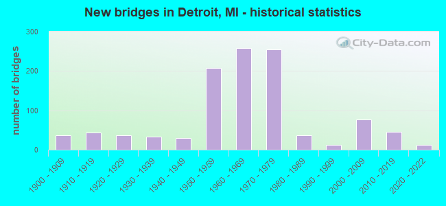
- New bridges - historical statistics
- 1Before 1900
- 371900-1909
- 431910-1919
- 371920-1929
- 331930-1939
- 291940-1949
- 2071950-1959
- 2591960-1969
- 2551970-1979
- 361980-1989
- 131990-1999
- 762000-2009
- 462010-2019
- 132020-2022
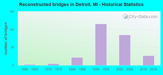
- Reconstructed bridges - Historical Statistics
- 31960-1969
- 51970-1979
- 221980-1989
- 1161990-1999
- 852000-2009
- 272010-2019
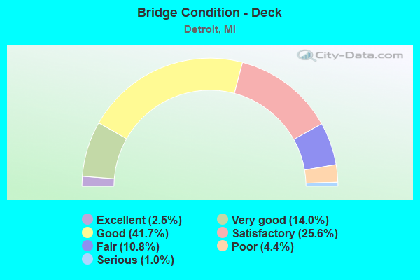
- Bridge Condition - Deck
- 2.5%Excellent
- 14.0%Very good
- 41.7%Good
- 25.6%Satisfactory
- 10.8%Fair
- 4.4%Poor
- 1.0%Serious
- Bridge Condition - Superstructure
- 2.3%Excellent
- 15.1%Very good
- 44.2%Good
- 22.8%Satisfactory
- 11.6%Fair
- 3.5%Poor
- 0.4%Serious
- Bridge Condition - Substructure
- 2.1%Excellent
- 10.0%Very good
- 41.9%Good
- 30.9%Satisfactory
- 12.2%Fair
- 2.5%Poor
- 0.4%Serious
- 0.2%Failed
- Bridge Condition - Channel
- 15.5%Very good
- 30.9%Good
- 25.5%Satisfactory
- 22.7%Fair
- 4.5%Poor
- 0.9%Serious
- Bridge Condition - Culverts
- 5.0%Excellent
- 40.0%Very good
- 20.0%Satisfactory
- 25.0%Fair
- 5.0%Poor
- 5.0%Serious
Find on map >> Show street view
Structure Number: 11832, Location: IN DETROIT (Lat: 42.369036, Lng: -83.058447), Route carried "on" structure: Ramp Interstate 75, Year Built: 1962, Status: Open, Structure Length: 5.88m (19.29ft), Average Daily Traffic: 10,110 (year 1982), Truck Traffic: 3%, Average Future Daily Traffic: 10,110 (year 1977), Design Load: HS 20+Mod, Features Intersected: I-75 SB
Minimum Vertical Clearance: 30.48m (100.00ft), Kilometerpoint: 0.074, Lanes on structure: 1, Lanes under structure: 3, Owner: State Highway Agency, Approaching Roadway Width: 7.9m (25.9ft), Skew: 5 degrees, Material/Design: Steel, Design/Construction: Stringer/Multi-beam, Number Of Spans In Main Unit: 2, Length of Maximum Span: 32.0m (105.0ft), Curb-To-Curb Width: 8.0m (26.2ft), Out-to-Out Width: 8.9m (29.2ft)
Condition: Deck: Satisfactory, Superstructure: Good, Substructure: Good, Operating Rating: 94.3 metric tons, Method Used To Determine Operating Rating: Load Factor (LF) rating reported by rating factor (RF) method using MS18 loading, Inventory Rating: 56.4 metric tons, Method Used To Determine Inventory Rating: Load Factor (LF) rating reported by rating factor (RF) method using MS18 loading, Structural Evaluation: Better than present minimum criteria, Deck Geometry: Superior to present desirable criteria, Underclear: Equal to present minimum criteria, Approach Roadway Alignment: Equal to present desirable criteria, Designated Inspection Frequency: Every 24 months, Inspection Date: April 2020, Bridge Improvement Cost: $21,000, Deck Structure Type: Concrete Cast-file-Place, Wearing Surface/Protective System: Wearing Surface: Latex Concrete
Find on map >> Show street view
Structure Number: 11833, Location: IN DETROIT (Lat: 42.369403, Lng: -83.056303), Route carried "on" structure: Ramp Interstate 75, Year Built: 1962, Status: Open, Structure Length: 10.97m (35.99ft), Average Daily Traffic: 10,110 (year 1982), Truck Traffic: 3%, Average Future Daily Traffic: 10,110 (year 1977), Design Load: HS 20+Mod, Features Intersected: I-94 RELIEF
Minimum Vertical Clearance: 30.48m (100.00ft), Kilometerpoint: 0.991, Lanes on structure: 1, Owner: State Highway Agency, Approaching Roadway Width: 7.9m (25.9ft), Skew: 9 degrees, Material/Design: Steel, Design/Construction: Stringer/Multi-beam, Number Of Spans In Main Unit: 5, Length of Maximum Span: 23.4m (76.8ft), Curb-To-Curb Width: 7.9m (25.9ft), Out-to-Out Width: 8.9m (29.2ft)
Condition: Deck: Satisfactory, Superstructure: Good, Substructure: Good, Operating Rating: 72.6 metric tons, Method Used To Determine Operating Rating: Load Factor (LF) rating reported by rating factor (RF) method using MS18 loading, Inventory Rating: 43.4 metric tons, Method Used To Determine Inventory Rating: Load Factor (LF) rating reported by rating factor (RF) method using MS18 loading, Structural Evaluation: Better than present minimum criteria, Deck Geometry: Equal to present desirable criteria, Approach Roadway Alignment: Equal to present desirable criteria, Designated Inspection Frequency: Every 24 months, Inspection Date: April 2020, Deck Structure Type: Concrete Cast-file-Place, Wearing Surface/Protective System: Wearing Surface: Latex Concrete
Find on map >> Show street view
Structure Number: 11838, Location: IN DETROIT (Lat: 42.414975, Lng: -83.084964), Route carried "on" structure: Interstate 75, Year Built: 1969, Year Reconstructed: 2003, Status: Open, Structure Length: 6.71m (22.01ft), Average Daily Traffic: 174,074 (year 2007), Truck Traffic: 7%, Average Future Daily Traffic: 183,398 (year 2018), Design Load: HS 20+Mod, Features Intersected: CONRAIL RR
Minimum Vertical Clearance: 30.48m (100.00ft), Kilometerpoint: 10.868, Lanes on structure: 10, Base Highway Network: Yes (Inventory Route: 157, Subroute: 6), Owner: State Highway Agency, Approaching Roadway Width: 50.0m (164.0ft), Skew: 39 degrees, Material/Design: Prestressed concrete, Design/Construction: Box Beam or Girders - Single/Spread, Number Of Spans In Main Unit: 4, Length of Maximum Span: 18.5m (60.7ft), Curb-To-Curb Width: 50.8m (166.7ft), Out-to-Out Width: 52.9m (173.6ft)
Condition: Deck: Good, Superstructure: Very good, Substructure: Good, Operating Rating: 54.8 metric tons, Method Used To Determine Operating Rating: Load Factor (LF) rating reported by rating factor (RF) method using MS18 loading, Inventory Rating: 26.9 metric tons, Method Used To Determine Inventory Rating: Load Factor (LF) rating reported by rating factor (RF) method using MS18 loading, Structural Evaluation: Equal to present minimum criteria, Deck Geometry: Superior to present desirable criteria, Underclear: Meets minimum limits, Approach Roadway Alignment: Equal to present desirable criteria, Designated Inspection Frequency: Every 24 months, Inspection Date: April 2020, Deck Structure Type: Concrete Cast-file-Place, Wearing Surface/Protective System: Wearing Surface: Monolithic Concrete, Deck Protection: Epoxy Coated Reinforcing
Find on map >> Show street view
Structure Number: 11839, Location: IN DETROIT (Lat: 42.407592, Lng: -83.080822), Route carried "on" structure: Ramp State highway 14, Year Built: 1971, Year Reconstructed: 2015, Status: Open, Structure Length: 6.71m (22.01ft), Average Daily Traffic: 22,520 (year 1982), Truck Traffic: 3%, Average Future Daily Traffic: 22,520 (year 1977), Design Load: HS 20+Mod, Features Intersected: GTW RR, Facility Carried by Structure: M-8 E-S RAMP
Minimum Vertical Clearance: 30.48m (100.00ft), Kilometerpoint: 0.613, Lanes on structure: 1, Owner: State Highway Agency, Approaching Roadway Width: 7.9m (25.9ft), Skew: 4 degrees, Material/Design: Steel, Design/Construction: Stringer/Multi-beam, Number Of Spans In Main Unit: 3, Length of Maximum Span: 28.9m (94.8ft), Curb or Sidewalk Widths: Left: 0.0m, Right: 2.4m (7.9ft), Curb-To-Curb Width: 5.1m (16.7ft), Out-to-Out Width: 8.5m (27.9ft)
Condition: Deck: Good, Superstructure: Satisfactory, Substructure: Good, Operating Rating: 86.5 metric tons, Method Used To Determine Operating Rating: Load Factor (LF) rating reported by rating factor (RF) method using MS18 loading, Inventory Rating: 51.8 metric tons, Method Used To Determine Inventory Rating: Load Factor (LF) rating reported by rating factor (RF) method using MS18 loading, Structural Evaluation: Equal to present minimum criteria, Deck Geometry: High priority of corrective action, Approach Roadway Alignment: Equal to present desirable criteria, Designated Inspection Frequency: Every 24 months, Inspection Date: November 2021, Deck Structure Type: Concrete Cast-file-Place, Wearing Surface/Protective System: Wearing Surface: Latex Concrete
Find on map >> Show street view
Structure Number: 1184, Location: IN DETROIT (Lat: 42.409269, Lng: -83.079750), Route carried "on" structure: ServiceState highway 8, Year Built: 1971, Year Reconstructed: 2021, Status: Open, Structure Length: 32.65m (107.12ft), Average Daily Traffic: 5,930 (year 2020), Truck Traffic: 4%, Average Future Daily Traffic: 6,295 (year 2040), Design Load: HS 20+Mod, Features Intersected: GTWRR,I-75&DAVISON(M-8), Facility Carried by Structure: DAVISON TO I-75 RP
Minimum Vertical Clearance: 30.48m (100.00ft), Kilometerpoint: 0.315, Lanes on structure: 1, Lanes under structure: 9, Owner: State Highway Agency, Approaching Roadway Width: 10.3m (33.8ft), Skew: 9 degrees, Material/Design: Steel continuous, Design/Construction: Stringer/Multi-beam, Number Of Spans In Main Unit: 9, Length of Maximum Span: 56.7m (186.0ft), Curb-To-Curb Width: 8.4m (27.6ft), Out-to-Out Width: 9.4m (30.8ft)
Condition: Deck: Excellent, Superstructure: Very good, Substructure: Fair, Operating Rating: 70.0 metric tons, Method Used To Determine Operating Rating: Load Factor (LF) rating reported by rating factor (RF) method using MS18 loading, Inventory Rating: 41.8 metric tons, Method Used To Determine Inventory Rating: Load Factor (LF) rating reported by rating factor (RF) method using MS18 loading, Structural Evaluation: Somewhat better than minimum adequacy, Deck Geometry: High priority of corrective action, Underclear: High priority of corrective action, Approach Roadway Alignment: Equal to present desirable criteria, Designated Inspection Frequency: Every 24 months, Inspection Date: Febuary 2022, Deck Structure Type: Concrete Cast-file-Place, Wearing Surface/Protective System: Wearing Surface: Monolithic Concrete, Deck Protection: Epoxy Coated Reinforcing
Find on map >> Show street view
Structure Number: 11842, Location: IN DETROIT (Lat: 42.373839, Lng: -83.059706), Route carried "on" structure: City street 2000, Year Built: 2021, Status: Open, Structure Length: 5.34m (17.52ft), Average Daily Traffic: 1,925 (year 2020), Truck Traffic: 3%, Average Future Daily Traffic: 2,150 (year 2040), Design Load: Greater than HL93, Features Intersected: I-75, Facility Carried by Structure: MILWAUKEE AVE
Minimum Vertical Clearance: 30.48m (100.00ft), Kilometerpoint: 2.136, Lanes on structure: 2, Lanes under structure: 8, Owner: State Highway Agency, Approaching Roadway Width: 13.4m (44.0ft), Skew: 1 degrees, Material/Design: Prestressed concrete, Design/Construction: Stringer/Multi-beam, Number Of Spans In Main Unit: 2, Length of Maximum Span: 27.0m (88.6ft), Curb or Sidewalk Widths: Left: 3.0m (9.8ft), Right: 3.0m (9.8ft), Curb-To-Curb Width: 11.6m (38.1ft), Out-to-Out Width: 18.4m (60.4ft)
Condition: Deck: Excellent, Superstructure: Excellent, Substructure: Excellent, Operating Rating: 55.7 metric tons, Method Used To Determine Operating Rating: Load and Resistance Factor Rating (LRFR) rating reported by rating factor(RF) method using HL-93 loadings, Inventory Rating: 43.1 metric tons, Method Used To Determine Inventory Rating: Load and Resistance Factor Rating (LRFR) rating reported by rating factor(RF) method using HL-93 loadings, Structural Evaluation: Superior to present desirable criteria, Deck Geometry: Equal to present minimum criteria, Underclear: High priority of corrective action, Approach Roadway Alignment: Equal to present desirable criteria, Designated Inspection Frequency: Every 24 months, Inspection Date: April 2021, Deck Structure Type: Concrete Cast-file-Place, Wearing Surface/Protective System: Wearing Surface: Monolithic Concrete, Deck Protection: Epoxy Coated Reinforcing
Find on map >> Show street view
Structure Number: 11843, Location: IN DETROIT (Lat: 42.374397, Lng: -83.059956), Route carried "on" structure: City street 2000, Year Built: 1968, Year Reconstructed: 2007, Status: Open, Structure Length: 4.64m (15.22ft), Average Daily Traffic: 15,700 (year 0000), Truck Traffic: 3%, Average Future Daily Traffic: 7,780 (year 2028), Design Load: HS 20, Features Intersected: I-75, Facility Carried by Structure: E GRAND BLVD
Minimum Vertical Clearance: 30.48m (100.00ft), Kilometerpoint: 7.379, Lanes on structure: 6, Lanes under structure: 8, Owner: State Highway Agency, Approaching Roadway Width: 12.2m (40.0ft), Skew: 36 degrees, Material/Design: Steel, Design/Construction: Stringer/Multi-beam, Number Of Spans In Main Unit: 2, Length of Maximum Span: 23.2m (76.1ft), Curb or Sidewalk Widths: Left: 3.3m (10.8ft), Right: 3.3m (10.8ft), Curb-To-Curb Width: 21.9m (71.9ft), Out-to-Out Width: 33.5m (109.9ft)
Condition: Deck: Good, Superstructure: Good, Substructure: Satisfactory, Operating Rating: 81.0 metric tons, Method Used To Determine Operating Rating: Load Factor (LF) rating reported by rating factor (RF) method using MS18 loading, Inventory Rating: 48.6 metric tons, Method Used To Determine Inventory Rating: Load Factor (LF) rating reported by rating factor (RF) method using MS18 loading, Structural Evaluation: Equal to present minimum criteria, Deck Geometry: High priority of corrective action, Underclear: High priority of corrective action, Approach Roadway Alignment: Equal to present desirable criteria, Designated Inspection Frequency: Every 24 months, Inspection Date: April 2020, Deck Structure Type: Concrete Cast-file-Place, Wearing Surface/Protective System: Wearing Surface: Monolithic Concrete, Deck Protection: Epoxy Coated Reinforcing
Find on map >> Show street view
Structure Number: 11844, Location: IN DETROIT (Lat: 42.378375, Lng: -83.062606), Route carried "on" structure: City street , Year Built: 1969, Year Reconstructed: 2007, Status: Open, Structure Length: 6.23m (20.44ft), Average Daily Traffic: 7,460 (year 1978), Truck Traffic: 3%, Average Future Daily Traffic: 6,560 (year 2028), Design Load: HS 20, Features Intersected: I-75, Facility Carried by Structure: CLAY AVE
Minimum Vertical Clearance: 30.48m (100.00ft), Kilometerpoint: 0.365, Lanes on structure: 6, Lanes under structure: 8, Owner: State Highway Agency, Approaching Roadway Width: 13.4m (44.0ft), Skew: 30 degrees, Material/Design: Steel, Design/Construction: Stringer/Multi-beam, Number Of Spans In Main Unit: 4, Length of Maximum Span: 22.9m (75.1ft), Curb or Sidewalk Widths: Left: 3.0m (9.8ft), Right: 3.0m (9.8ft), Curb-To-Curb Width: 25.2m (82.7ft), Out-to-Out Width: 32.0m (105.0ft)
Condition: Deck: Good, Superstructure: Satisfactory, Substructure: Satisfactory, Operating Rating: 60.6 metric tons, Method Used To Determine Operating Rating: Load Factor (LF) rating reported by rating factor (RF) method using MS18 loading, Inventory Rating: 36.3 metric tons, Method Used To Determine Inventory Rating: Load Factor (LF) rating reported by rating factor (RF) method using MS18 loading, Structural Evaluation: Equal to present minimum criteria, Deck Geometry: Somewhat better than minimum adequacy, Underclear: High priority of corrective action, Approach Roadway Alignment: Equal to present desirable criteria, Designated Inspection Frequency: Every 24 months, Inspection Date: April 2020, Deck Structure Type: Concrete Cast-file-Place, Wearing Surface/Protective System: Wearing Surface: Monolithic Concrete, Deck Protection: Epoxy Coated Reinforcing
Find on map >> Show street view
Structure Number: 11845, Location: IN DETROIT (Lat: 42.386572, Lng: -83.068094), Route carried "on" structure: City street 2000, Year Built: 1969, Year Reconstructed: 2007, Status: Open, Structure Length: 4.77m (15.65ft), Average Daily Traffic: 8,643 (year 2010), Truck Traffic: 3%, Average Future Daily Traffic: 9,507 (year 2025), Design Load: HS 20, Features Intersected: I-75, Facility Carried by Structure: HOLBROOK AVE
Minimum Vertical Clearance: 30.48m (100.00ft), Kilometerpoint: 1.201, Lanes on structure: 5, Lanes under structure: 8, Owner: State Highway Agency, Approaching Roadway Width: 18.0m (59.1ft), Skew: 31 degrees, Material/Design: Steel continuous, Design/Construction: Stringer/Multi-beam, Number Of Spans In Main Unit: 2, Length of Maximum Span: 23.9m (78.4ft), Curb or Sidewalk Widths: Left: 3.0m (9.8ft), Right: 1.1m (3.6ft), Curb-To-Curb Width: 22.9m (75.1ft), Out-to-Out Width: 30.7m (100.7ft)
Condition: Deck: Poor, Superstructure: Satisfactory, Substructure: Satisfactory, Operating Rating: 63.2 metric tons, Method Used To Determine Operating Rating: Load Factor (LF) rating reported by rating factor (RF) method using MS18 loading, Inventory Rating: 40.8 metric tons, Method Used To Determine Inventory Rating: Load Factor (LF) rating reported by rating factor (RF) method using MS18 loading, Structural Evaluation: Equal to present minimum criteria, Deck Geometry: Equal to present minimum criteria, Underclear: Meets minimum limits, Approach Roadway Alignment: Equal to present desirable criteria, Designated Inspection Frequency: Every 12 months, Inspection Date: April 2021, Deck Structure Type: Concrete Cast-file-Place, Wearing Surface/Protective System: Wearing Surface: Latex Concrete
Find on map >> Show street view
Structure Number: 11846, Location: IN DETROIT (Lat: 42.431700, Lng: -83.094800), Route carried "on" structure: Ramp City street 2000, Year Built: 2003, Status: Open, Structure Length: 6.60m (21.65ft), Average Daily Traffic: 5,000 (year 2007), Truck Traffic: 3%, Average Future Daily Traffic: 5,500 (year 2022), Design Load: HS 20+Mod, Features Intersected: I-75, Facility Carried by Structure: 7 MI RD NB LEFT TU
Minimum Vertical Clearance: 30.48m (100.00ft), Kilometerpoint: 0.063, Lanes on structure: 1, Lanes under structure: 8, Owner: State Highway Agency, Approaching Roadway Width: 5.4m (17.7ft), Material/Design: Prestressed concrete, Design/Construction: Box Beam or Girders - Single/Spread, Number Of Spans In Main Unit: 4, Length of Maximum Span: 22.9m (75.1ft), Curb-To-Curb Width: 6.3m (20.7ft), Out-to-Out Width: 7.3m (24.0ft)
Condition: Deck: Good, Superstructure: Good, Substructure: Good, Operating Rating: 57.3 metric tons, Method Used To Determine Operating Rating: Load Factor (LF) rating reported by rating factor (RF) method using MS18 loading, Inventory Rating: 34.3 metric tons, Method Used To Determine Inventory Rating: Load Factor (LF) rating reported by rating factor (RF) method using MS18 loading, Structural Evaluation: Better than present minimum criteria, Deck Geometry: Somewhat better than minimum adequacy, Underclear: Meets minimum limits, Approach Roadway Alignment: Equal to present desirable criteria, Designated Inspection Frequency: Every 24 months, Inspection Date: April 2020, Deck Structure Type: Concrete Cast-file-Place, Wearing Surface/Protective System: Wearing Surface: Monolithic Concrete, Deck Protection: Epoxy Coated Reinforcing
Find on map >> Show street view
Structure Number: 11847, Location: IN DETROIT (Lat: 42.432483, Lng: -83.094650), Route carried "on" structure: City street 2000, Year Built: 1967, Year Reconstructed: 2003, Status: Open, Structure Length: 6.70m (21.98ft), Average Daily Traffic: 16,738 (year 2010), Average Future Daily Traffic: 18,412 (year 2025), Design Load: HS 20, Features Intersected: I-75, Facility Carried by Structure: 7 MI RD
Minimum Vertical Clearance: 30.48m (100.00ft), Kilometerpoint: 27.862, Lanes on structure: 4, Lanes under structure: 8, Base Highway Network: Yes (Inventory Route: 170, Subroute: 6), Owner: State Highway Agency, Approaching Roadway Width: 13.4m (44.0ft), Material/Design: Steel, Design/Construction: Stringer/Multi-beam, Number Of Spans In Main Unit: 4, Length of Maximum Span: 22.8m (74.8ft), Curb or Sidewalk Widths: Left: 3.0m (9.8ft), Right: 3.0m (9.8ft), Curb-To-Curb Width: 14.6m (47.9ft), Out-to-Out Width: 21.4m (70.2ft)
Condition: Deck: Very good, Superstructure: Good, Substructure: Good, Operating Rating: 67.1 metric tons, Method Used To Determine Operating Rating: Load Factor (LF) rating reported by rating factor (RF) method using MS18 loading, Inventory Rating: 40.2 metric tons, Method Used To Determine Inventory Rating: Load Factor (LF) rating reported by rating factor (RF) method using MS18 loading, Structural Evaluation: Better than present minimum criteria, Deck Geometry: High priority of replacement, Underclear: High priority of corrective action, Approach Roadway Alignment: Equal to present desirable criteria, Designated Inspection Frequency: Every 24 months, Inspection Date: April 2020, Deck Structure Type: Concrete Cast-file-Place, Wearing Surface/Protective System: Deck Protection: Epoxy Coated Reinforcing
Find on map >> Show street view
Structure Number: 11848, Location: IN DETROIT (Lat: 42.433400, Lng: -83.095000), Route carried "on" structure: Ramp City street 2000, Year Built: 1967, Year Reconstructed: 2003, Status: Open, Structure Length: 6.59m (21.62ft), Average Daily Traffic: 4,900 (year 2007), Average Future Daily Traffic: 5,390 (year 2022), Design Load: HS 20+Mod, Features Intersected: I-75, Facility Carried by Structure: 7 MI RD SB LFT TRN
Minimum Vertical Clearance: 30.48m (100.00ft), Kilometerpoint: 0.056, Lanes on structure: 1, Lanes under structure: 8, Owner: State Highway Agency, Approaching Roadway Width: 5.4m (17.7ft), Material/Design: Prestressed concrete, Design/Construction: Box Beam or Girders - Single/Spread, Number Of Spans In Main Unit: 4, Length of Maximum Span: 22.4m (73.5ft), Curb-To-Curb Width: 6.3m (20.7ft), Out-to-Out Width: 7.3m (24.0ft)
Condition: Deck: Good, Superstructure: Satisfactory, Substructure: Satisfactory, Operating Rating: 67.1 metric tons, Method Used To Determine Operating Rating: Load Factor (LF) rating reported by rating factor (RF) method using MS18 loading, Inventory Rating: 39.9 metric tons, Method Used To Determine Inventory Rating: Load Factor (LF) rating reported by rating factor (RF) method using MS18 loading, Structural Evaluation: Equal to present minimum criteria, Deck Geometry: Somewhat better than minimum adequacy, Underclear: High priority of corrective action, Approach Roadway Alignment: Equal to present desirable criteria, Designated Inspection Frequency: Every 24 months, Inspection Date: April 2020, Deck Structure Type: Concrete Cast-file-Place, Wearing Surface/Protective System: Wearing Surface: Monolithic Concrete, Deck Protection: Epoxy Coated Reinforcing
Find on map >> Show street view
Structure Number: 11849, Location: IN DETROIT (Lat: 42.439756, Lng: -83.094775), Route carried "on" structure: City street 2000, Year Built: 1967, Year Reconstructed: 1997, Status: Open, Structure Length: 6.88m (22.57ft), Average Daily Traffic: 8,120 (year 2010), Truck Traffic: 6%, Average Future Daily Traffic: 8,932 (year 2025), Design Load: HS 20, Features Intersected: I-75, Facility Carried by Structure: STATE FAIR AVE
Minimum Vertical Clearance: 30.48m (100.00ft), Kilometerpoint: 2.081, Lanes on structure: 4, Lanes under structure: 10, Owner: State Highway Agency, Approaching Roadway Width: 13.4m (44.0ft), Material/Design: Steel, Design/Construction: Stringer/Multi-beam, Number Of Spans In Main Unit: 4, Length of Maximum Span: 28.1m (92.2ft), Curb or Sidewalk Widths: Left: 2.6m (8.5ft), Right: 2.6m (8.5ft), Curb-To-Curb Width: 15.6m (51.2ft), Out-to-Out Width: 21.5m (70.5ft)
Condition: Deck: Good, Superstructure: Good, Substructure: Satisfactory, Operating Rating: 86.2 metric tons, Method Used To Determine Operating Rating: Load Factor (LF) rating reported by rating factor (RF) method using MS18 loading, Inventory Rating: 51.5 metric tons, Method Used To Determine Inventory Rating: Load Factor (LF) rating reported by rating factor (RF) method using MS18 loading, Structural Evaluation: Equal to present minimum criteria, Deck Geometry: Meets minimum limits, Underclear: High priority of corrective action, Approach Roadway Alignment: Equal to present desirable criteria, Designated Inspection Frequency: Every 24 months, Inspection Date: April 2020, Deck Structure Type: Concrete Cast-file-Place, Wearing Surface/Protective System: Wearing Surface: Monolithic Concrete, Deck Protection: Epoxy Coated Reinforcing
Find on map >> Show street view
Structure Number: 1185, Location: IN DETROIT OVER I-75 SERV (Lat: 42.446814, Lng: -83.094347), Route carried "on" structure: State highway 102, Year Built: 1969, Status: Temporarily open, Structure Length: 32.56m (106.82ft), Average Daily Traffic: 60,400 (year 2013), Truck Traffic: 5%, Average Future Daily Traffic: 69,460 (year 2033), Design Load: HS 20, Features Intersected: I-75
Minimum Vertical Clearance: 30.48m (100.00ft), Kilometerpoint: 18.642, Lanes on structure: 6, Lanes under structure: 14, Base Highway Network: Yes (Inventory Route: 181, Subroute: 6), Owner: State Highway Agency, Approaching Roadway Width: 12.5m (41.0ft), Skew: 30 degrees, Material/Design: Steel continuous, Design/Construction: Stringer/Multi-beam, Number Of Spans In Main Unit: 11, Length of Maximum Span: 41.1m (134.8ft), Curb or Sidewalk Widths: Left: 0.6m (2.0ft), Right: 0.0m, Curb-To-Curb Width: 25.0m (82.0ft), Out-to-Out Width: 28.2m (92.5ft)
Condition: Deck: Poor, Superstructure: Satisfactory, Substructure: Poor, Operating Rating: 66.4 metric tons, Method Used To Determine Operating Rating: Load Factor (LF) rating reported by rating factor (RF) method using MS18 loading, Inventory Rating: 39.9 metric tons, Method Used To Determine Inventory Rating: Load Factor (LF) rating reported by rating factor (RF) method using MS18 loading, Structural Evaluation: Meets minimum limits, Deck Geometry: Somewhat better than minimum adequacy, Underclear: Meets minimum limits, Approach Roadway Alignment: Equal to present desirable criteria, Designated Inspection Frequency: Every 12 months, Other Special Inspection Frequency: Every 6 months, Inspection Date: March 2021, Other Special Inspection Date: September 2021, Bridge Improvement Cost: $362,000, Deck Structure Type: Concrete Cast-file-Place, Wearing Surface/Protective System: Wearing Surface: Latex Concrete
Find on map >> Show street view
Structure Number: 11851, Location: IN DETROIT (Lat: 42.446639, Lng: -83.094678), Route carried "on" structure: Ramp State highway 102, Year Built: 1969, Status: Open, Structure Length: 3.88m (12.73ft), Average Daily Traffic: 19,240 (year 1982), Average Future Daily Traffic: 22,126 (year 2002), Design Load: HS 20, Features Intersected: I-75
Minimum Vertical Clearance: 30.48m (100.00ft), Kilometerpoint: 0.481, Lanes on structure: 3, Lanes under structure: 6, Owner: State Highway Agency, Approaching Roadway Width: 12.5m (41.0ft), Skew: 10 degrees, Material/Design: Steel, Design/Construction: Stringer/Multi-beam, Number Of Spans In Main Unit: 2, Length of Maximum Span: 19.4m (63.6ft), Curb or Sidewalk Widths: Left: 0.0m, Right: 3.0m (9.8ft), Curb-To-Curb Width: 12.5m (41.0ft), Out-to-Out Width: 16.5m (54.1ft)
Condition: Deck: Satisfactory, Superstructure: Good, Substructure: Good, Operating Rating: 65.1 metric tons, Method Used To Determine Operating Rating: Load Factor (LF) rating reported by rating factor (RF) method using MS18 loading, Inventory Rating: 39.2 metric tons, Method Used To Determine Inventory Rating: Load Factor (LF) rating reported by rating factor (RF) method using MS18 loading, Structural Evaluation: Better than present minimum criteria, Deck Geometry: Meets minimum limits, Underclear: Meets minimum limits, Approach Roadway Alignment: Equal to present desirable criteria, Designated Inspection Frequency: Every 24 months, Inspection Date: March 2020, Deck Structure Type: Concrete Cast-file-Place, Wearing Surface/Protective System: Wearing Surface: Latex Concrete
Find on map >> Show street view
Structure Number: 11852, Location: IN DETROIT (Lat: 42.447100, Lng: -83.094700), Route carried "on" structure: Ramp State highway 102, Year Built: 1969, Status: Open, Structure Length: 3.87m (12.70ft), Average Daily Traffic: 14,430 (year 1982), Average Future Daily Traffic: 14,430 (year 1977), Design Load: HS 20, Features Intersected: I-75
Minimum Vertical Clearance: 30.48m (100.00ft), Kilometerpoint: 0.567, Lanes on structure: 3, Lanes under structure: 6, Owner: State Highway Agency, Approaching Roadway Width: 12.5m (41.0ft), Skew: 10 degrees, Material/Design: Steel, Design/Construction: Stringer/Multi-beam, Number Of Spans In Main Unit: 2, Length of Maximum Span: 19.5m (64.0ft), Curb or Sidewalk Widths: Left: 3.0m (9.8ft), Right: 0.0m, Curb-To-Curb Width: 12.7m (41.7ft), Out-to-Out Width: 16.5m (54.1ft)
Condition: Deck: Satisfactory, Superstructure: Good, Substructure: Good, Operating Rating: 77.8 metric tons, Method Used To Determine Operating Rating: Load Factor (LF) rating reported by rating factor (RF) method using MS18 loading, Inventory Rating: 46.7 metric tons, Method Used To Determine Inventory Rating: Load Factor (LF) rating reported by rating factor (RF) method using MS18 loading, Structural Evaluation: Better than present minimum criteria, Deck Geometry: Meets minimum limits, Underclear: Meets minimum limits, Approach Roadway Alignment: Equal to present desirable criteria, Designated Inspection Frequency: Every 24 months, Inspection Date: March 2020, Deck Structure Type: Concrete Cast-file-Place, Wearing Surface/Protective System: Wearing Surface: Latex Concrete
Find on map >> Show street view
Structure Number: 11857, Location: IN DETROIT OVER MODERN AV (Lat: 42.413878, Lng: -83.083847), Route carried "on" structure: Interstate 75, Year Built: 1969, Year Reconstructed: 2003, Status: Open, Structure Length: 4.09m (13.42ft), Average Daily Traffic: 174,074 (year 2007), Truck Traffic: 7%, Average Future Daily Traffic: 216,266 (year 2015), Design Load: HS 20+Mod, Features Intersected: MODERN AVE
Minimum Vertical Clearance: 30.48m (100.00ft), Kilometerpoint: 10.715, Lanes on structure: 10, Lanes under structure: 2, Base Highway Network: Yes (Inventory Route: 157, Subroute: 6), Owner: State Highway Agency, Approaching Roadway Width: 51.2m (168.0ft), Skew: 30 degrees, Material/Design: Steel, Design/Construction: Stringer/Multi-beam, Number Of Spans In Main Unit: 3, Length of Maximum Span: 14.5m (47.6ft), Curb-To-Curb Width: 52.1m (170.9ft), Out-to-Out Width: 52.9m (173.6ft)
Condition: Deck: Very good, Superstructure: Good, Substructure: Satisfactory, Operating Rating: 71.3 metric tons, Method Used To Determine Operating Rating: Load Factor (LF) rating reported by rating factor (RF) method using MS18 loading, Inventory Rating: 42.4 metric tons, Method Used To Determine Inventory Rating: Load Factor (LF) rating reported by rating factor (RF) method using MS18 loading, Structural Evaluation: Equal to present minimum criteria, Deck Geometry: Superior to present desirable criteria, Underclear: Meets minimum limits, Approach Roadway Alignment: Equal to present desirable criteria, Designated Inspection Frequency: Every 24 months, Inspection Date: April 2020, Deck Structure Type: Concrete Cast-file-Place, Wearing Surface/Protective System: Wearing Surface: Monolithic Concrete, Deck Protection: Epoxy Coated Reinforcing
Find on map >> Show street view
Structure Number: 11858, Location: IN DETROIT OVER MCNICHOLS (Lat: 42.418100, Lng: -83.087633), Route carried "on" structure: Interstate 75, Year Built: 1969, Year Reconstructed: 2003, Status: Open, Structure Length: 6.85m (22.47ft), Average Daily Traffic: 174,074 (year 2007), Truck Traffic: 7%, Average Future Daily Traffic: 200,500 (year 2022), Design Load: HS 20+Mod, Features Intersected: MCNICHOLS RD
Minimum Vertical Clearance: 30.48m (100.00ft), Kilometerpoint: 11.298, Lanes on structure: 8, Lanes under structure: 8, Base Highway Network: Yes (Inventory Route: 157, Subroute: 6), Owner: State Highway Agency, Approaching Roadway Width: 45.1m (148.0ft), Skew: 32 degrees, Material/Design: Prestressed concrete, Design/Construction: Stringer/Multi-beam, Number Of Spans In Main Unit: 4, Length of Maximum Span: 25.0m (82.0ft), Curb-To-Curb Width: 43.5m (142.7ft), Out-to-Out Width: 45.5m (149.3ft)
Condition: Deck: Very good, Superstructure: Good, Substructure: Very good, Operating Rating: 61.9 metric tons, Method Used To Determine Operating Rating: Load and Resistance Factor Rating (LRFR) rating reported by rating factor(RF) method using HL-93 loadings, Inventory Rating: 38.9 metric tons, Method Used To Determine Inventory Rating: Load and Resistance Factor Rating (LRFR) rating reported by rating factor(RF) method using HL-93 loadings, Structural Evaluation: Better than present minimum criteria, Deck Geometry: Superior to present desirable criteria, Underclear: Somewhat better than minimum adequacy, Approach Roadway Alignment: Equal to present desirable criteria, Designated Inspection Frequency: Every 24 months, Inspection Date: April 2020, Deck Structure Type: Concrete Cast-file-Place, Wearing Surface/Protective System: Wearing Surface: Monolithic Concrete, Deck Protection: Epoxy Coated Reinforcing
Find on map >> Show street view
Structure Number: 11859, Location: IN DETROIT (Lat: 42.424914, Lng: -83.093178), Route carried "on" structure: City street 2000, Year Built: 1969, Year Reconstructed: 2003, Status: Open, Structure Length: 7.34m (24.08ft), Average Daily Traffic: 7,418 (year 2010), Average Future Daily Traffic: 8,160 (year 2025), Design Load: HS 20, Features Intersected: I-75, Facility Carried by Structure: NEVADA AVE
Minimum Vertical Clearance: 30.48m (100.00ft), Kilometerpoint: 1.371, Lanes on structure: 4, Lanes under structure: 8, Owner: State Highway Agency, Approaching Roadway Width: 14.6m (47.9ft), Skew: 2 degrees, Material/Design: Steel, Design/Construction: Stringer/Multi-beam, Number Of Spans In Main Unit: 4, Length of Maximum Span: 25.9m (85.0ft), Curb or Sidewalk Widths: Left: 3.0m (9.8ft), Right: 3.0m (9.8ft), Curb-To-Curb Width: 14.6m (47.9ft), Out-to-Out Width: 21.4m (70.2ft)
Condition: Deck: Good, Superstructure: Satisfactory, Substructure: Good, Operating Rating: 75.5 metric tons, Method Used To Determine Operating Rating: Load Factor (LF) rating reported by rating factor (RF) method using MS18 loading, Inventory Rating: 45.0 metric tons, Method Used To Determine Inventory Rating: Load Factor (LF) rating reported by rating factor (RF) method using MS18 loading, Structural Evaluation: Equal to present minimum criteria, Deck Geometry: High priority of replacement, Underclear: High priority of corrective action, Approach Roadway Alignment: Equal to present desirable criteria, Designated Inspection Frequency: Every 22 months, Inspection Date: December 2021, Deck Structure Type: Concrete Cast-file-Place, Wearing Surface/Protective System: Wearing Surface: Monolithic Concrete, Deck Protection: Epoxy Coated Reinforcing
Find on map >> Show street view
Structure Number: 1186, Location: IN DETROIT (Lat: 42.425972, Lng: -83.093825), Route carried "on" structure: City street 2000, Year Built: 1967, Status: Open, Structure Length: 6.03m (19.78ft), Average Daily Traffic: 6,200 (year 1988), Truck Traffic: 3%, Average Future Daily Traffic: 7,130 (year 2008), Design Load: HS 20, Features Intersected: I-75, Facility Carried by Structure: SAVANNAH AVENUE
Minimum Vertical Clearance: 30.48m (100.00ft), Kilometerpoint: 6.409, Lanes on structure: 2, Lanes under structure: 8, Owner: State Highway Agency, Approaching Roadway Width: 7.9m (25.9ft), Skew: 3 degrees, Material/Design: Steel, Design/Construction: Stringer/Multi-beam, Number Of Spans In Main Unit: 2, Length of Maximum Span: 31.7m (104.0ft), Curb or Sidewalk Widths: Left: 0.7m (2.3ft), Right: 1.5m (4.9ft), Curb-To-Curb Width: 7.9m (25.9ft), Out-to-Out Width: 10.9m (35.8ft)
Condition: Deck: Satisfactory, Superstructure: Good, Substructure: Satisfactory, Operating Rating: 66.1 metric tons, Method Used To Determine Operating Rating: Load Factor (LF) rating reported by rating factor (RF) method using MS18 loading, Inventory Rating: 39.5 metric tons, Method Used To Determine Inventory Rating: Load Factor (LF) rating reported by rating factor (RF) method using MS18 loading, Structural Evaluation: Equal to present minimum criteria, Deck Geometry: High priority of corrective action, Underclear: High priority of corrective action, Approach Roadway Alignment: Equal to present minimum criteria, Designated Inspection Frequency: Every 22 months, Inspection Date: December 2021, Deck Structure Type: Concrete Cast-file-Place, Wearing Surface/Protective System: Wearing Surface: Monolithic Concrete
Find on map >> Show street view
Structure Number: 11861, Location: IN DETROIT (Lat: 42.444392, Lng: -83.094742), Route carried "on" structure: Ramp Interstate 75, Year Built: 1967, Year Reconstructed: 2003, Status: Open, Structure Length: 7.01m (23.00ft), Average Daily Traffic: 5,740 (year 1982), Truck Traffic: 3%, Average Future Daily Traffic: 6,601 (year 2002), Design Load: HS 20, Features Intersected: I-75
Minimum Vertical Clearance: 30.48m (100.00ft), Kilometerpoint: 0.061, Lanes on structure: 2, Lanes under structure: 7, Owner: State Highway Agency, Approaching Roadway Width: 8.5m (27.9ft), Skew: 3 degrees, Material/Design: Steel, Design/Construction: Stringer/Multi-beam, Number Of Spans In Main Unit: 3, Length of Maximum Span: 25.0m (82.0ft), Curb-To-Curb Width: 8.5m (27.9ft), Out-to-Out Width: 10.4m (34.1ft)
Condition: Deck: Good, Superstructure: Good, Substructure: Satisfactory, Operating Rating: 80.4 metric tons, Method Used To Determine Operating Rating: Load Factor (LF) rating reported by rating factor (RF) method using MS18 loading, Inventory Rating: 48.3 metric tons, Method Used To Determine Inventory Rating: Load Factor (LF) rating reported by rating factor (RF) method using MS18 loading, Structural Evaluation: Equal to present minimum criteria, Deck Geometry: High priority of corrective action, Underclear: High priority of corrective action, Approach Roadway Alignment: Somewhat better than minimum adequacy, Designated Inspection Frequency: Every 24 months, Inspection Date: March 2020, Deck Structure Type: Concrete Cast-file-Place, Wearing Surface/Protective System: Wearing Surface: Monolithic Concrete, Deck Protection: Epoxy Coated Reinforcing
Find on map >> Show street view
Structure Number: 11862, Location: IN DETROIT (Lat: 42.394642, Lng: -83.068228), Route carried "on" structure: Ramp City street 2000, Year Built: 1969, Year Reconstructed: 2007, Status: Open, Structure Length: 4.75m (15.58ft), Average Daily Traffic: 800 (year 1988), Truck Traffic: 3%, Average Future Daily Traffic: 980 (year 2028), Design Load: HS 20+Mod, Features Intersected: I-75, Facility Carried by Structure: DEQUINDRE U-TURN
Minimum Vertical Clearance: 30.48m (100.00ft), Kilometerpoint: 0.053, Lanes on structure: 1, Lanes under structure: 8, Owner: State Highway Agency, Approaching Roadway Width: 4.8m (15.7ft), Skew: 1 degrees, Material/Design: Steel, Design/Construction: Stringer/Multi-beam, Number Of Spans In Main Unit: 2, Length of Maximum Span: 23.8m (78.1ft), Curb or Sidewalk Widths: Left: 1.5m (4.9ft), Right: 0.0m, Curb-To-Curb Width: 6.0m (19.7ft), Out-to-Out Width: 8.4m (27.6ft)
Condition: Deck: Very good, Superstructure: Good, Substructure: Good, Operating Rating: 81.3 metric tons, Method Used To Determine Operating Rating: Load Factor (LF) rating reported by rating factor (RF) method using MS18 loading, Inventory Rating: 48.6 metric tons, Method Used To Determine Inventory Rating: Load Factor (LF) rating reported by rating factor (RF) method using MS18 loading, Structural Evaluation: Better than present minimum criteria, Deck Geometry: Meets minimum limits, Underclear: Equal to present minimum criteria, Approach Roadway Alignment: Equal to present desirable criteria, Designated Inspection Frequency: Every 24 months, Inspection Date: April 2020, Deck Structure Type: Concrete Cast-file-Place, Wearing Surface/Protective System: Wearing Surface: Monolithic Concrete, Deck Protection: Epoxy Coated Reinforcing
Find on map >> Show street view
Structure Number: 11863, Location: IN DETROIT (Lat: 42.406242, Lng: -83.075233), Route carried "on" structure: City street , Year Built: 1969, Year Reconstructed: 2021, Status: Open, Structure Length: 5.57m (18.27ft), Average Daily Traffic: 6,700 (year 1988), Truck Traffic: 3%, Average Future Daily Traffic: 7,705 (year 2008), Design Load: HS 20, Features Intersected: I-75, Facility Carried by Structure: MEADE ST
Minimum Vertical Clearance: 30.48m (100.00ft), Kilometerpoint: 0.052, Lanes on structure: 2, Lanes under structure: 10, Owner: State Highway Agency, Approaching Roadway Width: 9.1m (29.9ft), Material/Design: Steel continuous, Design/Construction: Stringer/Multi-beam, Number Of Spans In Main Unit: 2, Length of Maximum Span: 28.0m (91.9ft), Curb or Sidewalk Widths: Left: 2.4m (7.9ft), Right: 2.4m (7.9ft), Curb-To-Curb Width: 9.1m (29.9ft), Out-to-Out Width: 14.8m (48.6ft)
Condition: Deck: Excellent, Superstructure: Good, Substructure: Satisfactory, Operating Rating: 70.0 metric tons, Method Used To Determine Operating Rating: Load Factor (LF) rating reported by rating factor (RF) method using MS18 loading, Inventory Rating: 41.8 metric tons, Method Used To Determine Inventory Rating: Load Factor (LF) rating reported by rating factor (RF) method using MS18 loading, Structural Evaluation: Equal to present minimum criteria, Deck Geometry: High priority of corrective action, Underclear: High priority of corrective action, Approach Roadway Alignment: Equal to present desirable criteria, Designated Inspection Frequency: Every 24 months, Inspection Date: Febuary 2022, Deck Structure Type: Concrete Cast-file-Place, Wearing Surface/Protective System: Wearing Surface: Monolithic Concrete, Deck Protection: Epoxy Coated Reinforcing
Find on map >> Show street view
Structure Number: 11864, Location: IN DETROIT OVER RAMP C TO (Lat: 42.407581, Lng: -83.077944), Route carried "on" structure: Interstate 75, Year Built: 1969, Status: Open, Structure Length: 1.52m (4.99ft), Average Daily Traffic: 159,874 (year 2007), Truck Traffic: 8%, Average Future Daily Traffic: 160,728 (year 2018), Design Load: HS 20+Mod, Features Intersected: RAMP TO DAVISON(M-8)
Minimum Vertical Clearance: 30.48m (100.00ft), Kilometerpoint: 9.862, Lanes on structure: 8, Lanes under structure: 1, Base Highway Network: Yes (Inventory Route: 157, Subroute: 6), Owner: State Highway Agency, Approaching Roadway Width: 45.1m (148.0ft), Skew: 39 degrees, Material/Design: Steel, Design/Construction: Stringer/Multi-beam, Number Of Spans In Main Unit: 1, Length of Maximum Span: 14.6m (47.9ft), Curb or Sidewalk Widths: Left: 0.0m, Right: 2.0m (6.6ft), Curb-To-Curb Width: 42.7m (140.1ft), Out-to-Out Width: 45.1m (148.0ft)
Condition: Deck: Satisfactory, Superstructure: Good, Substructure: Satisfactory, Operating Rating: 68.7 metric tons, Method Used To Determine Operating Rating: Load Factor (LF) rating reported by rating factor (RF) method using MS18 loading, Inventory Rating: 41.1 metric tons, Method Used To Determine Inventory Rating: Load Factor (LF) rating reported by rating factor (RF) method using MS18 loading, Structural Evaluation: Equal to present minimum criteria, Deck Geometry: Superior to present desirable criteria, Underclear: High priority of corrective action, Approach Roadway Alignment: Equal to present desirable criteria, Designated Inspection Frequency: Every 22 months, Inspection Date: December 2021, Deck Structure Type: Concrete Cast-file-Place, Wearing Surface/Protective System: Wearing Surface: Latex Concrete
Find on map >> Show street view
Structure Number: 11865, Location: IN DETROIT OVER RAMP C TO (Lat: 42.408550, Lng: -83.076794), Route carried "on" structure: City street 2000, Year Built: 1969, Year Reconstructed: 2003, Status: Open, Structure Length: 1.67m (5.48ft), Average Daily Traffic: 19,800 (year 1988), Truck Traffic: 3%, Average Future Daily Traffic: 22,770 (year 2008), Design Load: HS 20, Features Intersected: I-75 RAMP TO DAVISON, Facility Carried by Structure: DEQUINDRE
Minimum Vertical Clearance: 30.48m (100.00ft), Kilometerpoint: 0.805, Lanes on structure: 4, Lanes under structure: 2, Base Highway Network: Yes (Inventory Route: 158, Subroute: 3), Owner: State Highway Agency, Approaching Roadway Width: 14.6m (47.9ft), Skew: 3 degrees, Material/Design: Steel, Design/Construction: Stringer/Multi-beam, Number Of Spans In Main Unit: 1, Length of Maximum Span: 16.7m (54.8ft), Curb or Sidewalk Widths: Left: 2.9m (9.5ft), Right: 3.3m (10.8ft), Curb-To-Curb Width: 14.5m (47.6ft), Out-to-Out Width: 21.8m (71.5ft)
Condition: Deck: Good, Superstructure: Good, Substructure: Good, Operating Rating: 97.2 metric tons, Method Used To Determine Operating Rating: Load Factor (LF) rating reported by rating factor (RF) method using MS18 loading, Inventory Rating: 61.6 metric tons, Method Used To Determine Inventory Rating: Load Factor (LF) rating reported by rating factor (RF) method using MS18 loading, Structural Evaluation: Better than present minimum criteria, Deck Geometry: High priority of replacement, Underclear: High priority of corrective action, Approach Roadway Alignment: Equal to present minimum criteria, Designated Inspection Frequency: Every 24 months, Inspection Date: April 2020, Deck Structure Type: Concrete Cast-file-Place, Wearing Surface/Protective System: Wearing Surface: Latex Concrete
Find on map >> Show street view
Structure Number: 11866, Location: IN DETROIT OVER RAMP C (Lat: 42.408847, Lng: -83.076528), Route carried "on" structure: ServiceState highway 14, Year Built: 1969, Year Reconstructed: 2003, Status: Open, Structure Length: 3.01m (9.88ft), Average Daily Traffic: 4,360 (year 1982), Truck Traffic: 3%, Average Future Daily Traffic: 5,014 (year 2002), Design Load: HS 20, Features Intersected: I-75 RAMP C, Facility Carried by Structure: DAVISON S SERV RD
Minimum Vertical Clearance: 30.48m (100.00ft), Kilometerpoint: 2.532, Lanes on structure: 2, Lanes under structure: 2, Owner: State Highway Agency, Approaching Roadway Width: 8.5m (27.9ft), Skew: 6 degrees, Material/Design: Steel, Design/Construction: Stringer/Multi-beam, Number Of Spans In Main Unit: 1, Length of Maximum Span: 30.1m (98.8ft), Curb or Sidewalk Widths: Left: 0.4m (1.3ft), Right: 3.0m (9.8ft), Curb-To-Curb Width: 8.8m (28.9ft), Out-to-Out Width: 12.7m (41.7ft)
Condition: Deck: Good, Superstructure: Good, Substructure: Satisfactory, Operating Rating: 74.5 metric tons, Method Used To Determine Operating Rating: Load Factor (LF) rating reported by rating factor (RF) method using MS18 loading, Inventory Rating: 44.7 metric tons, Method Used To Determine Inventory Rating: Load Factor (LF) rating reported by rating factor (RF) method using MS18 loading, Structural Evaluation: Equal to present minimum criteria, Deck Geometry: Meets minimum limits, Underclear: Meets minimum limits, Approach Roadway Alignment: Equal to present desirable criteria, Designated Inspection Frequency: Every 24 months, Inspection Date: April 2020, Deck Structure Type: Concrete Cast-file-Place, Wearing Surface/Protective System: Wearing Surface: Latex Concrete, Deck Protection: Epoxy Coated Reinforcing
Find on map >> Show street view
Structure Number: 11867, Location: IN DETROIT (Lat: 42.408644, Lng: -83.079083), Route carried "on" structure: Interstate 75, Year Built: 1969, Status: Temporarily open, Structure Length: 7.95m (26.08ft), Average Daily Traffic: 159,874 (year 2007), Truck Traffic: 8%, Average Future Daily Traffic: 160,728 (year 2018), Design Load: HS 20+Mod, Features Intersected: M-8 DAVISON & SERVIC RDS
Minimum Vertical Clearance: 4.26m (13.98ft), Kilometerpoint: 10.031, Lanes on structure: 9, Lanes under structure: 8, Base Highway Network: Yes (Inventory Route: 157, Subroute: 6), Owner: State Highway Agency, Approaching Roadway Width: 45.1m (148.0ft), Skew: 31 degrees, Material/Design: Steel continuous, Design/Construction: Stringer/Multi-beam, Number Of Spans In Main Unit: 4, Length of Maximum Span: 19.5m (64.0ft), Curb or Sidewalk Widths: Left: 0.2m (0.7ft), Right: 0.2m (0.7ft), Curb-To-Curb Width: 63.9m (209.6ft), Out-to-Out Width: 64.9m (212.9ft)
Condition: Deck: Fair, Superstructure: Satisfactory, Substructure: Good, Structural Evaluation: High priority of corrective action, Deck Geometry: High priority of corrective action, Underclear: High priority of corrective action, Approach Roadway Alignment: Equal to present desirable criteria, Designated Inspection Frequency: Every 15 months, Inspection Date: January 2022, Bridge Improvement Cost: $205,000, Deck Structure Type: Concrete Cast-file-Place, Wearing Surface/Protective System: Wearing Surface: Latex Concrete
Find on map >> Show street view
Structure Number: 11868, Location: IN DETROIT OVER I-75 RAMP (Lat: 42.408536, Lng: -83.079567), Route carried "on" structure: Ramp Interstate 75, Year Built: 1969, Status: Open, Structure Length: 20.09m (65.91ft), Average Daily Traffic: 17,730 (year 1982), Truck Traffic: 3%, Average Future Daily Traffic: 17,730 (year 1977), Design Load: HS 20+Mod, Features Intersected: I-75, Facility Carried by Structure: DAVISON RAMP(M-8)
Minimum Vertical Clearance: 30.48m (100.00ft), Kilometerpoint: 0.161, Lanes on structure: 1, Lanes under structure: 10, Owner: State Highway Agency, Approaching Roadway Width: 8.5m (27.9ft), Material/Design: Steel continuous, Design/Construction: Stringer/Multi-beam, Number Of Spans In Main Unit: 6, Length of Maximum Span: 41.4m (135.8ft), Curb or Sidewalk Widths: Left: 1.5m (4.9ft), Right: 0.0m, Curb-To-Curb Width: 7.4m (24.3ft), Out-to-Out Width: 8.6m (28.2ft)
Condition: Deck: Fair, Superstructure: Good, Substructure: Good, Operating Rating: 87.5 metric tons, Method Used To Determine Operating Rating: Load Factor (LF) rating reported by rating factor (RF) method using MS18 loading, Inventory Rating: 52.2 metric tons, Method Used To Determine Inventory Rating: Load Factor (LF) rating reported by rating factor (RF) method using MS18 loading, Structural Evaluation: Better than present minimum criteria, Deck Geometry: Better than present minimum criteria, Underclear: High priority of corrective action, Approach Roadway Alignment: Equal to present desirable criteria, Designated Inspection Frequency: Every 15 months, Inspection Date: Febuary 2022, Deck Structure Type: Concrete Cast-file-Place, Wearing Surface/Protective System: Wearing Surface: Latex Concrete
Find on map >> Show street view
Structure Number: 11869, Location: IN DETROIT (Lat: 42.409186, Lng: -83.077222), Route carried "on" structure: City street 2000, Year Built: 1969, Year Reconstructed: 2003, Status: Open, Structure Length: 6.09m (19.98ft), Average Daily Traffic: 23,900 (year 1978), Truck Traffic: 3%, Average Future Daily Traffic: 16,150 (year 2020), Design Load: HS 20, Features Intersected: M-8 DAVISON, Facility Carried by Structure: DEQUINDRE AVE
Minimum Vertical Clearance: 30.48m (100.00ft), Kilometerpoint: 0.884, Lanes on structure: 4, Lanes under structure: 6, Owner: State Highway Agency, Approaching Roadway Width: 14.6m (47.9ft), Skew: 1 degrees, Material/Design: Prestressed concrete, Design/Construction: Stringer/Multi-beam, Number Of Spans In Main Unit: 4, Length of Maximum Span: 19.1m (62.7ft), Curb or Sidewalk Widths: Left: 3.0m (9.8ft), Right: 3.0m (9.8ft), Curb-To-Curb Width: 14.6m (47.9ft), Out-to-Out Width: 21.6m (70.9ft)
Condition: Deck: Good, Superstructure: Very good, Substructure: Good, Operating Rating: 57.0 metric tons, Method Used To Determine Operating Rating: Load Factor (LF) rating reported by rating factor (RF) method using MS18 loading, Inventory Rating: 34.0 metric tons, Method Used To Determine Inventory Rating: Load Factor (LF) rating reported by rating factor (RF) method using MS18 loading, Structural Evaluation: Better than present minimum criteria, Deck Geometry: High priority of replacement, Underclear: High priority of corrective action, Approach Roadway Alignment: Equal to present desirable criteria, Designated Inspection Frequency: Every 24 months, Inspection Date: April 2020, Deck Structure Type: Concrete Cast-file-Place, Wearing Surface/Protective System: Wearing Surface: Latex Concrete, Deck Protection: Epoxy Coated Reinforcing
Find on map >> Show street view
Structure Number: 1187, Location: IN DETROIT OVER N-W RAMPT (Lat: 42.410083, Lng: -83.080419), Route carried "on" structure: Interstate 75, Year Built: 1969, Year Reconstructed: 2003, Status: Open, Structure Length: 1.52m (4.99ft), Average Daily Traffic: 174,074 (year 2007), Truck Traffic: 7%, Average Future Daily Traffic: 183,398 (year 2018), Design Load: HS 20+Mod, Features Intersected: RAMP D TO DAVISON(M-8)
Minimum Vertical Clearance: 30.48m (100.00ft), Kilometerpoint: 10.208, Lanes on structure: 7, Lanes under structure: 1, Base Highway Network: Yes (Inventory Route: 157, Subroute: 6), Owner: State Highway Agency, Approaching Roadway Width: 41.4m (135.8ft), Skew: 39 degrees, Material/Design: Steel, Design/Construction: Stringer/Multi-beam, Number Of Spans In Main Unit: 1, Length of Maximum Span: 15.2m (49.9ft), Curb or Sidewalk Widths: Left: 0.2m (0.7ft), Right: 0.2m (0.7ft), Curb-To-Curb Width: 44.4m (145.7ft), Out-to-Out Width: 45.0m (147.6ft)
Condition: Deck: Good, Superstructure: Good, Substructure: Good, Operating Rating: 79.4 metric tons, Method Used To Determine Operating Rating: Load Factor (LF), Inventory Rating: 47.6 metric tons, Method Used To Determine Inventory Rating: Load Factor (LF), Structural Evaluation: Better than present minimum criteria, Deck Geometry: Superior to present desirable criteria, Underclear: High priority of corrective action, Approach Roadway Alignment: Equal to present desirable criteria, Designated Inspection Frequency: Every 15 months, Inspection Date: Febuary 2022, Deck Structure Type: Concrete Cast-file-Place, Wearing Surface/Protective System: Wearing Surface: Monolithic Concrete, Deck Protection: Epoxy Coated Reinforcing
Find on map >> Show street view
Structure Number: 11871, Location: IN DETROIT OVER DEQUINDRE (Lat: 42.409700, Lng: -83.077597), Route carried "on" structure: Ramp Interstate 75, Year Built: 1971, Status: Open, Structure Length: 10.70m (35.10ft), Average Daily Traffic: 23,920 (year 1982), Average Future Daily Traffic: 23,920 (year 1977), Design Load: HS 20+Mod, Features Intersected: DEQUINDRE AVE
Minimum Vertical Clearance: 30.48m (100.00ft), Kilometerpoint: 0.571, Lanes on structure: 2, Lanes under structure: 4, Owner: State Highway Agency, Approaching Roadway Width: 12.2m (40.0ft), Material/Design: Steel, Design/Construction: Stringer/Multi-beam, Number Of Spans In Main Unit: 4, Length of Maximum Span: 42.0m (137.8ft), Curb or Sidewalk Widths: Left: 0.2m (0.7ft), Right: 0.2m (0.7ft), Curb-To-Curb Width: 11.4m (37.4ft), Out-to-Out Width: 12.1m (39.7ft)
Condition: Deck: Good, Superstructure: Good, Substructure: Good, Operating Rating: 85.9 metric tons, Method Used To Determine Operating Rating: Load Factor (LF) rating reported by rating factor (RF) method using MS18 loading, Inventory Rating: 51.5 metric tons, Method Used To Determine Inventory Rating: Load Factor (LF) rating reported by rating factor (RF) method using MS18 loading, Structural Evaluation: Better than present minimum criteria, Deck Geometry: Superior to present desirable criteria, Underclear: High priority of corrective action, Approach Roadway Alignment: Equal to present desirable criteria, Designated Inspection Frequency: Every 24 months, Critical Feature Inspection Frequency: Every 15 months, Inspection Date: Febuary 2022, Critical Feature Inspection Date: April 2021, Bridge Improvement Cost: $51,000, Deck Structure Type: Concrete Cast-file-Place, Wearing Surface/Protective System: Wearing Surface: Latex Concrete
Find on map >> Show street view
Structure Number: 12061, Location: DETROIT E/TELEGRAPH (Lat: 42.357358, Lng: -83.259028), Route carried "on" structure: County highway 2000, Year Built: 1927, Year Reconstructed: 1971, Status: Open, Structure Length: 2.95m (9.68ft), Average Daily Traffic: 11,655 (year 1997), Truck Traffic: 1%, Average Future Daily Traffic: 12,754 (year 2015), Design Load: HS 20+Mod, Features Intersected: UPPER ROUGE RIVER, Facility Carried by Structure: JOY ROAD
Minimum Vertical Clearance: 30.48m (100.00ft), Kilometerpoint: 9.318, Lanes on structure: 4, Owner: County Highway Agency, Approaching Roadway Width: 18.9m (62.0ft), Skew: 3 degrees, Material/Design: Concrete, Design/Construction: Tee Beam, Number Of Spans In Main Unit: 2, Length of Maximum Span: 13.4m (44.0ft), Curb or Sidewalk Widths: Left: 1.8m (5.9ft), Right: 1.8m (5.9ft), Curb-To-Curb Width: 14.6m (47.9ft), Out-to-Out Width: 19.0m (62.3ft)
Condition: Deck: Poor, Superstructure: Fair, Substructure: Fair, Channel: Fair, Operating Rating: 66.4 metric tons, Method Used To Determine Operating Rating: Load Factor (LF) rating reported by rating factor (RF) method using MS18 loading, Inventory Rating: 39.9 metric tons, Method Used To Determine Inventory Rating: Load Factor (LF) rating reported by rating factor (RF) method using MS18 loading, Structural Evaluation: Somewhat better than minimum adequacy, Deck Geometry: High priority of replacement, Waterway Adequacy: Equal to present desirable criteria, Approach Roadway Alignment: Equal to present desirable criteria, Designated Inspection Frequency: Every 12 months, Inspection Date: September 2021, Deck Structure Type: Concrete Cast-file-Place, Wearing Surface/Protective System: Wearing Surface: Bituminous
Find on map >> Show street view
Structure Number: 12079, Location: DETROIT E/TELEGRAPH (Lat: 42.399967, Lng: -83.271542), Route carried "on" structure: County highway 2000, Year Built: 1963, Status: Posted for load, Structure Length: 6.18m (20.28ft), Average Daily Traffic: 14,707 (year 1995), Truck Traffic: 5%, Average Future Daily Traffic: 16,949 (year 2015), Design Load: HS 20, Features Intersected: UPPER ROUGE RIVER, Facility Carried by Structure: FIVE MILE ROAD
Minimum Vertical Clearance: 30.48m (100.00ft), Kilometerpoint: 3.579, Lanes on structure: 4, Owner: County Highway Agency, Approaching Roadway Width: 14.6m (47.9ft), Skew: 3 degrees, Material/Design: Steel, Design/Construction: Stringer/Multi-beam, Number Of Spans In Main Unit: 3, Length of Maximum Span: 24.3m (79.7ft), Curb or Sidewalk Widths: Left: 3.0m (9.8ft), Right: 3.0m (9.8ft), Curb-To-Curb Width: 14.6m (47.9ft), Out-to-Out Width: 21.3m (69.9ft)
Condition: Deck: Serious, Superstructure: Poor, Substructure: Satisfactory, Channel: Satisfactory, Operating Rating: 43.7 metric tons, Method Used To Determine Operating Rating: Load Factor (LF) rating reported by rating factor (RF) method using MS18 loading, Inventory Rating: 26.2 metric tons, Method Used To Determine Inventory Rating: Load Factor (LF) rating reported by rating factor (RF) method using MS18 loading, Structural Evaluation: Meets minimum limits, Deck Geometry: High priority of replacement, Waterway Adequacy: Equal to present desirable criteria, Approach Roadway Alignment: Equal to present desirable criteria, Bridge Posting: Required (Relationship of Operating Rating to Maximum Legal Load: 20.0 - 29.9% below), Designated Inspection Frequency: Every 12 months, Inspection Date: June 2021, Deck Structure Type: Concrete Cast-file-Place, Wearing Surface/Protective System: Wearing Surface: Bituminous
Find on map >> Show street view
Structure Number: 12091, Location: DETROIT E/TELEGRAPH (Lat: 42.414725, Lng: -83.266842), Route carried "on" structure: County highway 2000, Year Built: 1927, Year Reconstructed: 1995, Status: Open, Structure Length: 2.98m (9.78ft), Average Daily Traffic: 12,661 (year 1997), Truck Traffic: 1%, Average Future Daily Traffic: 13,000 (year 2015), Design Load: HS 25 or greater, Features Intersected: UPPER ROUGE RIVER, Facility Carried by Structure: SIX MILE ROAD
Minimum Vertical Clearance: 30.48m (100.00ft), Kilometerpoint: 23.396, Lanes on structure: 5, Base Highway Network: Yes (Inventory Route: 168, Subroute: 1), Owner: County Highway Agency, Approaching Roadway Width: 20.1m (65.9ft), Skew: 3 degrees, Material/Design: Prestressed concrete, Design/Construction: Box Beam or Girders - Multiple, Number Of Spans In Main Unit: 2, Length of Maximum Span: 14.6m (47.9ft), Curb or Sidewalk Widths: Left: 2.2m (7.2ft), Right: 2.2m (7.2ft), Curb-To-Curb Width: 20.1m (65.9ft), Out-to-Out Width: 25.3m (83.0ft)
Condition: Deck: Satisfactory, Superstructure: Good, Substructure: Fair, Channel: Serious, Operating Rating: 97.2 metric tons, Method Used To Determine Operating Rating: Load Factor (LF) rating reported by rating factor (RF) method using MS18 loading, Inventory Rating: 75.5 metric tons, Method Used To Determine Inventory Rating: Load Factor (LF) rating reported by rating factor (RF) method using MS18 loading, Structural Evaluation: Somewhat better than minimum adequacy, Deck Geometry: Somewhat better than minimum adequacy, Waterway Adequacy: Better than present minimum criteria, Approach Roadway Alignment: Equal to present desirable criteria, Designated Inspection Frequency: Every 24 months, Inspection Date: June 2021, Deck Structure Type: Concrete Cast-file-Place, Wearing Surface/Protective System: Wearing Surface: Integral Concrete, Deck Protection: Epoxy Coated Reinforcing
Find on map >> Show street view
Structure Number: 12097, Location: DETROIT E/TELEGRAPH (Lat: 42.429147, Lng: -83.269097), Route carried "on" structure: County highway 2000, Year Built: 1930, Year Reconstructed: 1984, Status: Posted for load, Structure Length: 2.43m (7.97ft), Average Daily Traffic: 19,931 (year 1995), Truck Traffic: 5%, Average Future Daily Traffic: 17,500 (year 2015), Features Intersected: UPPER ROUGE RIVER, Facility Carried by Structure: SEVEN MILE ROAD
Minimum Vertical Clearance: 30.48m (100.00ft), Kilometerpoint: 13.501, Lanes on structure: 6, Base Highway Network: Yes (Inventory Route: 170, Subroute: 6), Owner: County Highway Agency, Approaching Roadway Width: 20.1m (65.9ft), Material/Design: Prestressed concrete, Design/Construction: Stringer/Multi-beam, Number Of Spans In Main Unit: 1, Length of Maximum Span: 22.8m (74.8ft), Curb or Sidewalk Widths: Left: 1.5m (4.9ft), Right: 1.5m (4.9ft), Curb-To-Curb Width: 20.1m (65.9ft), Out-to-Out Width: 23.9m (78.4ft)
Condition: Deck: Good, Superstructure: Very good, Substructure: Fair, Channel: Satisfactory, Operating Rating: 48.3 metric tons, Method Used To Determine Operating Rating: Load Factor (LF) rating reported by rating factor (RF) method using MS18 loading, Inventory Rating: 28.8 metric tons, Method Used To Determine Inventory Rating: Load Factor (LF) rating reported by rating factor (RF) method using MS18 loading, Structural Evaluation: Somewhat better than minimum adequacy, Deck Geometry: High priority of replacement, Waterway Adequacy: Equal to present desirable criteria, Approach Roadway Alignment: Equal to present desirable criteria, Bridge Posting: Required (Relationship of Operating Rating to Maximum Legal Load: 10.0 - 19.9% below), Designated Inspection Frequency: Every 24 months, Inspection Date: May 2020, Deck Structure Type: Concrete Cast-file-Place, Wearing Surface/Protective System: Wearing Surface: Monolithic Concrete, Deck Protection: Epoxy Coated Reinforcing
Find on map >> Show street view
Structure Number: 12098, Location: DETROIT N/SIX MILE (Lat: 42.420011, Lng: -83.013694), Route carried "on" structure: County highway 2000, Year Built: 1946, Status: Open, Structure Length: 1.06m (3.48ft), Average Daily Traffic: 21,584 (year 2001), Truck Traffic: 2%, Average Future Daily Traffic: 26,230 (year 2015), Design Load: HS 20, Features Intersected: MT OLIVET CEMETERY DR, Facility Carried by Structure: OUTER DRIVE
Minimum Vertical Clearance: 30.48m (100.00ft), Kilometerpoint: 0.043, Lanes on structure: 7, Lanes under structure: 2, Owner: County Highway Agency, Approaching Roadway Width: 13.4m (44.0ft), Material/Design: Concrete, Design/Construction: Frame, Number Of Spans In Main Unit: 1, Length of Maximum Span: 8.8m (28.9ft), Curb or Sidewalk Widths: Left: 4.2m (13.8ft), Right: 7.0m (23.0ft), Curb-To-Curb Width: 13.4m (44.0ft), Out-to-Out Width: 47.2m (154.9ft)
Condition: Deck: Fair, Superstructure: Fair, Substructure: Satisfactory, Operating Rating: 40.8 metric tons, Method Used To Determine Operating Rating: Load Factor (LF) rating reported by rating factor (RF) method using MS18 loading, Inventory Rating: 24.6 metric tons, Method Used To Determine Inventory Rating: Load Factor (LF) rating reported by rating factor (RF) method using MS18 loading, Structural Evaluation: Somewhat better than minimum adequacy, Deck Geometry: High priority of replacement, Underclear: High priority of corrective action, Approach Roadway Alignment: Equal to present desirable criteria, Designated Inspection Frequency: Every 24 months, Inspection Date: June 2021
Find on map >> Show street view
Structure Number: 12181, Location: DETROIT E/TELEGRAPH (Lat: 42.357125, Lng: -83.261797), Route carried "on" structure: County highway 2000, Year Built: 1927, Status: Posted for load, Structure Length: 2.28m (7.48ft), Average Daily Traffic: 5,416 (year 1996), Truck Traffic: 1%, Average Future Daily Traffic: 4,788 (year 2015), Design Load: HS 20+Mod, Features Intersected: JOY ROAD, Facility Carried by Structure: OUTER DRIVE
Minimum Vertical Clearance: 30.48m (100.00ft), Kilometerpoint: 4.410, Lanes on structure: 4, Lanes under structure: 4, Owner: County Highway Agency, Approaching Roadway Width: 17.0m (55.8ft), Material/Design: Concrete, Design/Construction: Arch - Deck, Number Of Spans In Main Unit: 1, Length of Maximum Span: 21.3m (69.9ft), Curb or Sidewalk Widths: Left: 3.0m (9.8ft), Right: 3.0m (9.8ft), Curb-To-Curb Width: 12.2m (40.0ft), Out-to-Out Width: 19.5m (64.0ft)
Condition: Superstructure: Poor, Substructure: Fair, Operating Rating: 29.8 metric tons, Method Used To Determine Operating Rating: Load Factor (LF) rating reported by rating factor (RF) method using MS18 loading, Inventory Rating: 28.8 metric tons, Method Used To Determine Inventory Rating: Load Factor (LF) rating reported by rating factor (RF) method using MS18 loading, Structural Evaluation: Meets minimum limits, Deck Geometry: High priority of replacement, Underclear: High priority of corrective action, Approach Roadway Alignment: Equal to present desirable criteria, Bridge Posting: Required (Relationship of Operating Rating to Maximum Legal Load: 0.1 - 9.9% below), Designated Inspection Frequency: Every 12 months, Inspection Date: May 2021