Bridge Statistics for Detroit, Michigan (MI)
Condition, Traffic, Stress, Structural Evaluation, Project Costs
- National Bridge Inventory (NBI) Statistics
- 1,085Number of bridges
- 12,034ft / 3,668mTotal length
- $82,595,000Total costs
- 55,047,582Total average daily traffic
- 3,107,918Total average daily truck traffic
- National Bridge Inventory (NBI) Registered Bridges for Detroit
- No street view available for this location
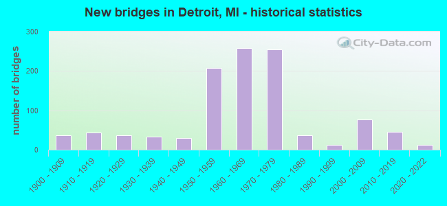
- New bridges - historical statistics
- 1Before 1900
- 371900-1909
- 431910-1919
- 371920-1929
- 331930-1939
- 291940-1949
- 2071950-1959
- 2591960-1969
- 2551970-1979
- 361980-1989
- 131990-1999
- 762000-2009
- 462010-2019
- 132020-2022
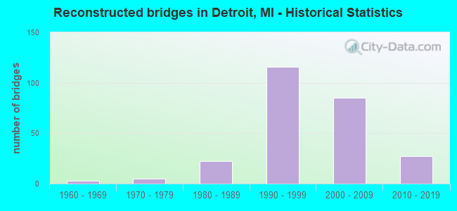
- Reconstructed bridges - Historical Statistics
- 31960-1969
- 51970-1979
- 221980-1989
- 1161990-1999
- 852000-2009
- 272010-2019
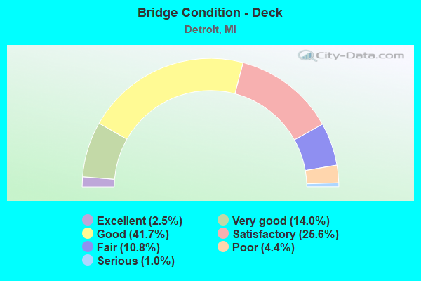
- Bridge Condition - Deck
- 2.5%Excellent
- 14.0%Very good
- 41.7%Good
- 25.6%Satisfactory
- 10.8%Fair
- 4.4%Poor
- 1.0%Serious
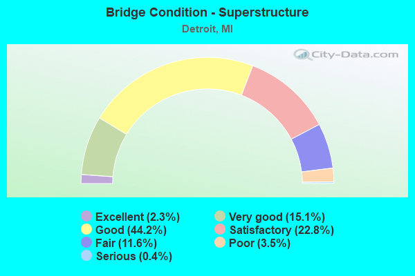
- Bridge Condition - Superstructure
- 2.3%Excellent
- 15.1%Very good
- 44.2%Good
- 22.8%Satisfactory
- 11.6%Fair
- 3.5%Poor
- 0.4%Serious
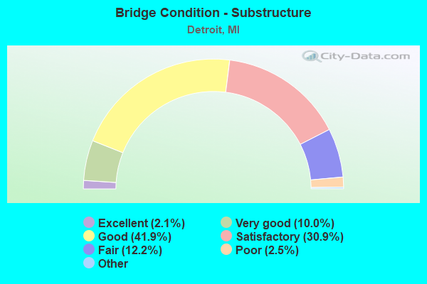
- Bridge Condition - Substructure
- 2.1%Excellent
- 10.0%Very good
- 41.9%Good
- 30.9%Satisfactory
- 12.2%Fair
- 2.5%Poor
- 0.4%Serious
- 0.2%Failed
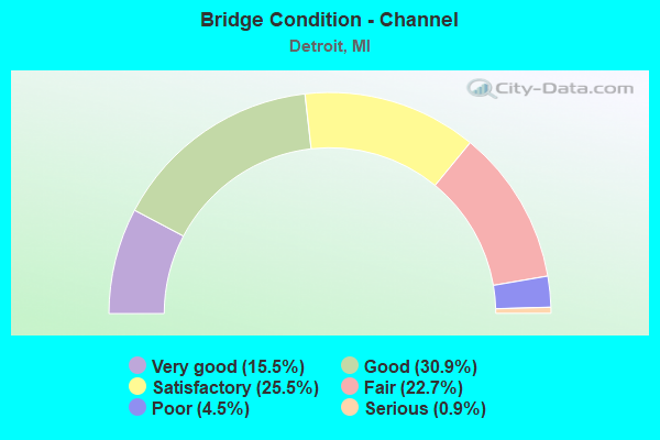
- Bridge Condition - Channel
- 15.5%Very good
- 30.9%Good
- 25.5%Satisfactory
- 22.7%Fair
- 4.5%Poor
- 0.9%Serious
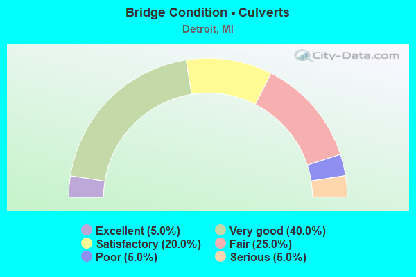
- Bridge Condition - Culverts
- 5.0%Excellent
- 40.0%Very good
- 20.0%Satisfactory
- 25.0%Fair
- 5.0%Poor
- 5.0%Serious
Find on map >> Show street view
Structure Number: 1174, Location: QUINCY TWP SEC 12 (Lat: 41.962100, Lng: -84.840442), Route carried "on" structure: County highway , Year Built: 1989, Status: Open, Structure Length: 1.76m (5.77ft), Average Daily Traffic: 210 (year 2004), Truck Traffic: 2%, Average Future Daily Traffic: 242 (year 2024), Design Load: HS 20+Mod, Features Intersected: SOUTH BR HOG CREEK, Facility Carried by Structure: BOONE ROAD
Minimum Vertical Clearance: 30.48m (100.00ft), Kilometerpoint: 1.502, Lanes on structure: 2, Owner: County Highway Agency, Approaching Roadway Width: 6.1m (20.0ft), Material/Design: Prestressed concrete, Design/Construction: Box Beam or Girders - Multiple, Number Of Spans In Main Unit: 1, Length of Maximum Span: 16.7m (54.8ft), Curb-To-Curb Width: 9.1m (29.9ft), Out-to-Out Width: 9.5m (31.2ft)
Condition: Deck: Good, Superstructure: Good, Substructure: Good, Channel: Good, Operating Rating: 66.6 metric tons, Method Used To Determine Operating Rating: Load Factor (LF), Inventory Rating: 40.0 metric tons, Method Used To Determine Inventory Rating: Load Factor (LF), Structural Evaluation: Better than present minimum criteria, Deck Geometry: Equal to present minimum criteria, Waterway Adequacy: Equal to present desirable criteria, Approach Roadway Alignment: Equal to present desirable criteria, Designated Inspection Frequency: Every 24 months, Inspection Date: October 2020, Deck Structure Type: Concrete Precast Panels, Wearing Surface/Protective System: Wearing Surface: Bituminous, Membrane: Preformed Fabric, Deck Protection: Epoxy Coated Reinforcing
Find on map >> Show street view
Structure Number: 1175, Location: QUINCY TWP SEC 19 (Lat: 41.939400, Lng: -84.941700), Route carried "on" structure: County highway , Year Built: 1984, Status: Open, Structure Length: 0.76m (2.49ft), Average Daily Traffic: 220 (year 2004), Truck Traffic: 2%, Average Future Daily Traffic: 250 (year 2024), Design Load: H 20, Features Intersected: SAUK RIVER, Facility Carried by Structure: FOX ROAD
Minimum Vertical Clearance: 30.48m (100.00ft), Kilometerpoint: 1.239, Lanes on structure: 2, Owner: County Highway Agency, Approaching Roadway Width: 6.1m (20.0ft), Material/Design: Steel, Design/Construction: Culvert, Number Of Spans In Main Unit: 2, Length of Maximum Span: 3.0m (9.8ft), Curb-To-Curb Width: 8.5m (27.9ft), Out-to-Out Width: 8.5m (27.9ft)
Condition: Channel: Satisfactory, Culverts: Serious, Operating Rating: 97.2 metric tons, Method Used To Determine Operating Rating: Load Factor (LF) rating reported by rating factor (RF) method using MS18 loading, Inventory Rating: 93.6 metric tons, Method Used To Determine Inventory Rating: Load Factor (LF) rating reported by rating factor (RF) method using MS18 loading, Structural Evaluation: High priority of corrective action, Deck Geometry: Equal to present minimum criteria, Waterway Adequacy: Equal to present desirable criteria, Approach Roadway Alignment: Equal to present desirable criteria, Designated Inspection Frequency: Every 12 months, Inspection Date: October 2021, Wearing Surface/Protective System: Wearing Surface: Bituminous
Find on map >> Show street view
Structure Number: 1178, Location: UNION TWP SEC 23 (Lat: 42.021614, Lng: -85.090708), Route carried "on" structure: County highway , Year Built: 1905, Status: Closed, Structure Length: 2.68m (8.79ft), Average Daily Traffic: 108 (year 2004), Average Future Daily Traffic: 161 (year 2024), Features Intersected: COLDWATER RIVER, Facility Carried by Structure: STANCER ROAD
Minimum Vertical Clearance: 30+ m (98+ ft), Kilometerpoint: 3.130, Lanes on structure: 1, Owner: County Highway Agency, Approaching Roadway Width: 6.1m (20.0ft), Material/Design: Steel, Design/Construction: Truss - Thru, Number Of Spans In Main Unit: 1, Length of Maximum Span: 26.8m (87.9ft), Curb-To-Curb Width: 4.3m (14.1ft), Out-to-Out Width: 4.3m (14.1ft)
Condition: Deck: Fair, Superstructure: Serious, Substructure: Fair, Channel: Poor, Operating Rating: 9.3 metric tons, Method Used To Determine Operating Rating: Allowable Stress (AS), Inventory Rating: 5.8 metric tons, Method Used To Determine Inventory Rating: Allowable Stress (AS), Waterway Adequacy: Equal to present desirable criteria, Approach Roadway Alignment: High priority of corrective action, Bridge Posting: Required (Relationship of Operating Rating to Maximum Legal Load: > 39.9% below), Length Of Structure Improvement: 3.66m (12.01ft), Designated Inspection Frequency: Every 24 months, Inspection Date: October 2021, Bridge Improvement Cost: $345,000, Roadway Improvement Cost: $44,000, Total Project Cost: $565,000, Deck Structure Type: Wood or Timber, Wearing Surface/Protective System: Wearing Surface: Wood or Timber
Find on map >> Show street view
Structure Number: 1181, Location: NEAR RIVERSIDE DRIVE (Lat: 41.935644, Lng: -85.009872), Route carried "on" structure: City street , Year Built: 1950, Status: Open, Structure Length: 1.00m (3.28ft), Average Daily Traffic: 800 (year 1987), Truck Traffic: 2%, Average Future Daily Traffic: 1,000 (year 2011), Features Intersected: SAUK(COLDWATER) RIVER, Facility Carried by Structure: RACE STREET
Minimum Vertical Clearance: 30.48m (100.00ft), Kilometerpoint: 1.973, Lanes on structure: 2, Owner: City or Municipal Highway Agency, Approaching Roadway Width: 11.9m (39.0ft), Skew: 3 degrees, Material/Design: Steel, Design/Construction: Culvert, Number Of Spans In Main Unit: 2, Length of Maximum Span: 4.5m (14.8ft), Curb or Sidewalk Widths: Left: 0.9m (3.0ft), Right: 1.2m (3.9ft)
Condition: Channel: Fair, Culverts: Fair, Operating Rating: 35.2 metric tons, Method Used To Determine Operating Rating: Load Factor (LF), Inventory Rating: 32.7 metric tons, Method Used To Determine Inventory Rating: Load Factor (LF), Structural Evaluation: Somewhat better than minimum adequacy, Waterway Adequacy: Equal to present minimum criteria, Approach Roadway Alignment: Better than present minimum criteria, Designated Inspection Frequency: Every 24 months, Inspection Date: May 2021
Find on map >> Show street view
Structure Number: 1183, Location: IN COLDWATER (Lat: 41.941119, Lng: -85.020653), Route carried "on" structure: City street 2035, Year Built: 1976, Status: Open, Structure Length: 1.54m (5.05ft), Average Daily Traffic: 2,800 (year 1991), Truck Traffic: 4%, Average Future Daily Traffic: 3,700 (year 2011), Design Load: HS 20, Features Intersected: SAUK (COLDWATER) RIVER, Facility Carried by Structure: BUTTERS AVENUE
Minimum Vertical Clearance: 30.48m (100.00ft), Kilometerpoint: 1.634, Lanes on structure: 2, Owner: City or Municipal Highway Agency, Approaching Roadway Width: 13.4m (44.0ft), Material/Design: Prestressed concrete, Design/Construction: Box Beam or Girders - Multiple, Number Of Spans In Main Unit: 1, Length of Maximum Span: 14.8m (48.6ft), Curb or Sidewalk Widths: Left: 0.4m (1.3ft), Right: 1.8m (5.9ft), Curb-To-Curb Width: 15.9m (52.2ft), Out-to-Out Width: 18.8m (61.7ft)
Condition: Deck: Fair, Superstructure: Good, Substructure: Good, Channel: Good, Operating Rating: 53.1 metric tons, Method Used To Determine Operating Rating: Load Factor (LF), Inventory Rating: 31.8 metric tons, Method Used To Determine Inventory Rating: Load Factor (LF), Structural Evaluation: Better than present minimum criteria, Deck Geometry: Superior to present desirable criteria, Waterway Adequacy: Superior to present desirable criteria, Approach Roadway Alignment: Superior to present desirable criteria, Designated Inspection Frequency: Every 24 months, Inspection Date: May 2021, Deck Structure Type: Other, Wearing Surface/Protective System: Wearing Surface: Bituminous, Membrane: Preformed Fabric
Find on map >> Show street view
Structure Number: 1184, Location: IN COLDWATER (Lat: 41.939947, Lng: -85.015017), Route carried "on" structure: City street 2035, Year Built: 1951, Status: Open, Structure Length: 1.13m (3.71ft), Average Daily Traffic: 2,850 (year 1989), Truck Traffic: 4%, Average Future Daily Traffic: 3,500 (year 2011), Design Load: H 20, Features Intersected: SAUK (COLDWATER) RIVER, Facility Carried by Structure: JAY STREET
Minimum Vertical Clearance: 30.48m (100.00ft), Kilometerpoint: 2.108, Lanes on structure: 2, Owner: City or Municipal Highway Agency, Approaching Roadway Width: 9.1m (29.9ft), Skew: 1 degrees, Material/Design: Concrete, Design/Construction: Tee Beam, Number Of Spans In Main Unit: 1, Length of Maximum Span: 10.8m (35.4ft), Curb or Sidewalk Widths: Left: 0.5m (1.6ft), Right: 1.2m (3.9ft), Curb-To-Curb Width: 9.8m (32.2ft), Out-to-Out Width: 12.3m (40.4ft)
Condition: Deck: Good, Superstructure: Satisfactory, Substructure: Satisfactory, Channel: Fair, Operating Rating: 54.5 metric tons, Method Used To Determine Operating Rating: Load Factor (LF), Inventory Rating: 32.7 metric tons, Method Used To Determine Inventory Rating: Load Factor (LF), Structural Evaluation: Equal to present minimum criteria, Deck Geometry: Meets minimum limits, Waterway Adequacy: Superior to present desirable criteria, Approach Roadway Alignment: Equal to present desirable criteria, Designated Inspection Frequency: Every 24 months, Inspection Date: May 2021, Deck Structure Type: Concrete Cast-file-Place, Wearing Surface/Protective System: Wearing Surface: Monolithic Concrete
Find on map >> Show street view
Structure Number: 1185, Location: IN COLDWATER (Lat: 41.932878, Lng: -85.005250), Route carried "on" structure: City street 2035, Year Built: 1951, Status: Posted for load, Structure Length: 1.23m (4.04ft), Average Daily Traffic: 1,800 (year 1989), Truck Traffic: 2%, Average Future Daily Traffic: 2,300 (year 2011), Design Load: H 20, Features Intersected: SAUK (COLDWATER) RIVER, Facility Carried by Structure: CLAY STREET
Minimum Vertical Clearance: 30.48m (100.00ft), Kilometerpoint: 0.138, Lanes on structure: 2, Owner: City or Municipal Highway Agency, Approaching Roadway Width: 13.1m (43.0ft), Skew: 3 degrees, Material/Design: Concrete, Design/Construction: Tee Beam, Number Of Spans In Main Unit: 1, Length of Maximum Span: 11.8m (38.7ft), Curb or Sidewalk Widths: Left: 0.5m (1.6ft), Right: 1.2m (3.9ft), Curb-To-Curb Width: 9.8m (32.2ft), Out-to-Out Width: 12.3m (40.4ft)
Condition: Deck: Fair, Superstructure: Satisfactory, Substructure: Good, Channel: Satisfactory, Operating Rating: 51.5 metric tons, Method Used To Determine Operating Rating: Load Factor (LF) rating reported by rating factor (RF) method using MS18 loading, Inventory Rating: 30.8 metric tons, Method Used To Determine Inventory Rating: Load Factor (LF) rating reported by rating factor (RF) method using MS18 loading, Structural Evaluation: Equal to present minimum criteria, Deck Geometry: Somewhat better than minimum adequacy, Waterway Adequacy: Superior to present desirable criteria, Approach Roadway Alignment: Equal to present desirable criteria, Designated Inspection Frequency: Every 24 months, Inspection Date: May 2021, Deck Structure Type: Concrete Cast-file-Place, Wearing Surface/Protective System: Wearing Surface: Bituminous, Membrane: Preformed Fabric
Find on map >> Show street view
Structure Number: 1186, Location: IN COLDWATER (Lat: 41.930075, Lng: -84.998817), Route carried "on" structure: City street 2035, Year Built: 1951, Status: Posted for load, Structure Length: 1.07m (3.51ft), Average Daily Traffic: 1,658 (year 2016), Truck Traffic: 1%, Average Future Daily Traffic: 1,950 (year 2036), Design Load: H 20, Features Intersected: SAUK (COLDWATER) RIVER, Facility Carried by Structure: JEFFERSON STREET
Minimum Vertical Clearance: 30.48m (100.00ft), Kilometerpoint: 0.312, Lanes on structure: 2, Owner: City or Municipal Highway Agency, Approaching Roadway Width: 7.7m (25.3ft), Material/Design: Concrete, Design/Construction: Tee Beam, Number Of Spans In Main Unit: 1, Length of Maximum Span: 10.1m (33.1ft), Curb-To-Curb Width: 8.4m (27.6ft), Out-to-Out Width: 9.4m (30.8ft)
Condition: Deck: Good, Superstructure: Good, Substructure: Good, Channel: Good, Operating Rating: 33.7 metric tons, Method Used To Determine Operating Rating: Load Factor (LF) rating reported by rating factor (RF) method using MS18 loading, Inventory Rating: 20.1 metric tons, Method Used To Determine Inventory Rating: Load Factor (LF) rating reported by rating factor (RF) method using MS18 loading, Structural Evaluation: Somewhat better than minimum adequacy, Deck Geometry: Meets minimum limits, Waterway Adequacy: Equal to present desirable criteria, Approach Roadway Alignment: Equal to present desirable criteria, Bridge Posting: Required (Relationship of Operating Rating to Maximum Legal Load: 20.0 - 29.9% below), Designated Inspection Frequency: Every 24 months, Inspection Date: May 2021, Deck Structure Type: Concrete Cast-file-Place, Wearing Surface/Protective System: Wearing Surface: Latex Concrete
Find on map >> Show street view
Structure Number: 1187, Location: CITY OF COLDWATER (Lat: 41.933067, Lng: -84.990661), Route carried "on" structure: City street 2035, Year Built: 1951, Status: Posted for load, Structure Length: 1.07m (3.51ft), Average Daily Traffic: 3,500 (year 1989), Truck Traffic: 4%, Average Future Daily Traffic: 4,600 (year 2011), Design Load: H 20, Features Intersected: COLDWATER RIVER, Facility Carried by Structure: SPRAGUE STREET
Minimum Vertical Clearance: 30.48m (100.00ft), Kilometerpoint: 2.741, Lanes on structure: 2, Owner: City or Municipal Highway Agency, Approaching Roadway Width: 10.1m (33.1ft), Material/Design: Concrete, Design/Construction: Tee Beam, Number Of Spans In Main Unit: 1, Length of Maximum Span: 10.1m (33.1ft), Curb or Sidewalk Widths: Left: 0.5m (1.6ft), Right: 1.2m (3.9ft), Curb-To-Curb Width: 7.9m (25.9ft), Out-to-Out Width: 10.4m (34.1ft)
Condition: Deck: Good, Superstructure: Good, Substructure: Good, Channel: Satisfactory, Operating Rating: 26.9 metric tons, Method Used To Determine Operating Rating: Load Factor (LF) rating reported by rating factor (RF) method using MS18 loading, Inventory Rating: 16.2 metric tons, Method Used To Determine Inventory Rating: Load Factor (LF) rating reported by rating factor (RF) method using MS18 loading, Structural Evaluation: Meets minimum limits, Deck Geometry: High priority of corrective action, Waterway Adequacy: Equal to present minimum criteria, Approach Roadway Alignment: Equal to present desirable criteria, Bridge Posting: Required (Relationship of Operating Rating to Maximum Legal Load: > 39.9% below), Designated Inspection Frequency: Every 24 months, Inspection Date: May 2021, Deck Structure Type: Concrete Cast-file-Place, Wearing Surface/Protective System: Wearing Surface: Monolithic Concrete
Find on map >> Show street view
Structure Number: 1234, Location: 0.7 MI N OF BRANCH COL (Lat: 42.078042, Lng: -84.989139), Route carried "on" structure: County highway 1355, Year Built: 1968, Status: Open, Structure Length: 7.68m (25.20ft), Average Daily Traffic: 3,343 (year 1992), Truck Traffic: 3%, Average Future Daily Traffic: 4,146 (year 2000), Design Load: HS 20, Features Intersected: I-69, Facility Carried by Structure: OLD US-27
Minimum Vertical Clearance: 30.48m (100.00ft), Kilometerpoint: 0.668, Lanes on structure: 2, Lanes under structure: 4, Base Highway Network: Yes (Inventory Route: 313, Subroute: 51), Owner: State Highway Agency, Approaching Roadway Width: 12.2m (40.0ft), Skew: 1 degrees, Material/Design: Steel, Design/Construction: Stringer/Multi-beam, Number Of Spans In Main Unit: 4, Length of Maximum Span: 26.8m (87.9ft), Curb-To-Curb Width: 9.9m (32.5ft), Out-to-Out Width: 11.1m (36.4ft)
Condition: Deck: Satisfactory, Superstructure: Fair, Substructure: Good, Operating Rating: 71.0 metric tons, Method Used To Determine Operating Rating: Load Factor (LF) rating reported by rating factor (RF) method using MS18 loading, Inventory Rating: 42.4 metric tons, Method Used To Determine Inventory Rating: Load Factor (LF) rating reported by rating factor (RF) method using MS18 loading, Structural Evaluation: Somewhat better than minimum adequacy, Deck Geometry: Meets minimum limits, Underclear: Somewhat better than minimum adequacy, Approach Roadway Alignment: Equal to present desirable criteria, Designated Inspection Frequency: Every 24 months, Inspection Date: June 2021, Deck Structure Type: Concrete Cast-file-Place, Wearing Surface/Protective System: Wearing Surface: Monolithic Concrete
Find on map >> Show street view
Structure Number: 1237, Location: @ I-94 (Lat: 42.297611, Lng: -84.996211), Route carried "on" structure: Ramp Interstate 69, Year Built: 1968, Status: Open, Structure Length: 10.85m (35.60ft), Average Daily Traffic: 7,500 (year 1995), Truck Traffic: 24%, Average Future Daily Traffic: 8,500 (year 2015), Design Load: HS 20+Mod, Features Intersected: I-94
Minimum Vertical Clearance: 30.48m (100.00ft), Kilometerpoint: 0.758, Lanes on structure: 2, Lanes under structure: 8, Owner: State Highway Agency, Approaching Roadway Width: 9.9m (32.5ft), Material/Design: Steel, Design/Construction: Stringer/Multi-beam, Number Of Spans In Main Unit: 4, Length of Maximum Span: 28.3m (92.8ft), Curb-To-Curb Width: 9.8m (32.2ft), Out-to-Out Width: 10.7m (35.1ft)
Condition: Deck: Satisfactory, Superstructure: Fair, Substructure: Satisfactory, Operating Rating: 66.1 metric tons, Method Used To Determine Operating Rating: Load Factor (LF) rating reported by rating factor (RF) method using MS18 loading, Inventory Rating: 39.5 metric tons, Method Used To Determine Inventory Rating: Load Factor (LF) rating reported by rating factor (RF) method using MS18 loading, Structural Evaluation: Somewhat better than minimum adequacy, Deck Geometry: Equal to present minimum criteria, Underclear: Equal to present minimum criteria, Approach Roadway Alignment: Equal to present desirable criteria, Designated Inspection Frequency: Every 24 months, Inspection Date: June 2021, Deck Structure Type: Concrete Cast-file-Place, Wearing Surface/Protective System: Wearing Surface: Latex Concrete
Find on map >> Show street view
Structure Number: 1238, Location: 7.5 MI N OF BRANCH COL (Lat: 42.173717, Lng: -84.984250), Route carried "on" structure: County highway , Year Built: 1968, Year Reconstructed: 2010, Status: Open, Structure Length: 4.59m (15.06ft), Truck Traffic: 6%, Average Future Daily Traffic: 364 (year 2030), Design Load: HS 20, Features Intersected: I-69 NB, Facility Carried by Structure: J DRIVE S
Minimum Vertical Clearance: 30.48m (100.00ft), Kilometerpoint: 6.187, Lanes on structure: 2, Lanes under structure: 2, Owner: State Highway Agency, Approaching Roadway Width: 9.8m (32.2ft), Skew: 2 degrees, Material/Design: Steel, Design/Construction: Stringer/Multi-beam, Number Of Spans In Main Unit: 3, Length of Maximum Span: 21.7m (71.2ft), Curb-To-Curb Width: 9.8m (32.2ft), Out-to-Out Width: 10.5m (34.4ft)
Condition: Deck: Good, Superstructure: Fair, Substructure: Good, Operating Rating: 62.1 metric tons, Method Used To Determine Operating Rating: Load Factor (LF), Inventory Rating: 37.3 metric tons, Method Used To Determine Inventory Rating: Load Factor (LF), Structural Evaluation: Somewhat better than minimum adequacy, Deck Geometry: Equal to present desirable criteria, Underclear: Meets minimum limits, Approach Roadway Alignment: Equal to present desirable criteria, Designated Inspection Frequency: Every 24 months, Inspection Date: June 2021, Deck Structure Type: Concrete Cast-file-Place, Wearing Surface/Protective System: Wearing Surface: Monolithic Concrete, Deck Protection: Epoxy Coated Reinforcing
Find on map >> Show street view
Structure Number: 1239, Location: 2.0 MI S OF I-94 (Lat: 42.270192, Lng: -84.990689), Route carried "on" structure: Business Interstate 94, Year Built: 1968, Year Reconstructed: 2006, Status: Open, Structure Length: 8.54m (28.02ft), Average Daily Traffic: 18,636 (year 2015), Truck Traffic: 2%, Average Future Daily Traffic: 21,925 (year 2035), Design Load: HS 20, Features Intersected: I-69
Minimum Vertical Clearance: 30.48m (100.00ft), Kilometerpoint: 0.840, Lanes on structure: 2, Lanes under structure: 4, Base Highway Network: Yes (Inventory Route: 130, Subroute: 2), Owner: State Highway Agency, Approaching Roadway Width: 11.1m (36.4ft), Material/Design: Steel, Design/Construction: Stringer/Multi-beam, Number Of Spans In Main Unit: 4, Length of Maximum Span: 25.3m (83.0ft), Curb-To-Curb Width: 9.6m (31.5ft), Out-to-Out Width: 10.6m (34.8ft)
Condition: Deck: Satisfactory, Superstructure: Fair, Substructure: Satisfactory, Operating Rating: 68.7 metric tons, Method Used To Determine Operating Rating: Load Factor (LF) rating reported by rating factor (RF) method using MS18 loading, Inventory Rating: 41.1 metric tons, Method Used To Determine Inventory Rating: Load Factor (LF) rating reported by rating factor (RF) method using MS18 loading, Structural Evaluation: Somewhat better than minimum adequacy, Deck Geometry: Meets minimum limits, Underclear: Somewhat better than minimum adequacy, Approach Roadway Alignment: Equal to present desirable criteria, Designated Inspection Frequency: Every 24 months, Inspection Date: June 2021, Deck Structure Type: Concrete Cast-file-Place, Wearing Surface/Protective System: Wearing Surface: Latex Concrete
Find on map >> Show street view
Structure Number: 1241, Location: 3.0 MI N OF MARSHALL (Lat: 42.319403, Lng: -84.992786), Route carried "on" structure: County highway , Year Built: 1970, Status: Open, Structure Length: 8.05m (26.41ft), Average Daily Traffic: 3,000 (year 2020), Average Future Daily Traffic: 3,250 (year 2040), Design Load: H 15, Features Intersected: I-69, Facility Carried by Structure: J DRIVE N
Minimum Vertical Clearance: 30.48m (100.00ft), Kilometerpoint: 4.175, Lanes on structure: 2, Lanes under structure: 4, Owner: State Highway Agency, Approaching Roadway Width: 6.7m (22.0ft), Material/Design: Steel, Design/Construction: Stringer/Multi-beam, Number Of Spans In Main Unit: 2, Length of Maximum Span: 40.2m (131.9ft), Curb-To-Curb Width: 10.5m (34.4ft), Out-to-Out Width: 11.7m (38.4ft)
Condition: Deck: Good, Superstructure: Fair, Substructure: Good, Operating Rating: 63.5 metric tons, Method Used To Determine Operating Rating: Load Factor (LF) rating reported by rating factor (RF) method using MS18 loading, Inventory Rating: 37.9 metric tons, Method Used To Determine Inventory Rating: Load Factor (LF) rating reported by rating factor (RF) method using MS18 loading, Structural Evaluation: Somewhat better than minimum adequacy, Deck Geometry: Somewhat better than minimum adequacy, Underclear: Equal to present minimum criteria, Approach Roadway Alignment: Equal to present desirable criteria, Designated Inspection Frequency: Every 24 months, Inspection Date: October 2021, Deck Structure Type: Concrete Cast-file-Place, Wearing Surface/Protective System: Wearing Surface: Latex Concrete
Find on map >> Show street view
Structure Number: 1242, Location: 2.5 MI N OF I-94 (Lat: 42.332669, Lng: -84.986850), Route carried "on" structure: County highway 1357, Year Built: 1970, Year Reconstructed: 2015, Status: Open, Structure Length: 11.09m (36.38ft), Average Daily Traffic: 1,060 (year 2015), Truck Traffic: 3%, Average Future Daily Traffic: 1,175 (year 2035), Design Load: H 15, Features Intersected: I-69, Facility Carried by Structure: L DRIVE NORTH
Minimum Vertical Clearance: 30.48m (100.00ft), Kilometerpoint: 4.110, Lanes on structure: 2, Lanes under structure: 5, Owner: State Highway Agency, Approaching Roadway Width: 10.5m (34.4ft), Material/Design: Steel, Design/Construction: Stringer/Multi-beam, Number Of Spans In Main Unit: 5, Length of Maximum Span: 30.0m (98.4ft), Curb-To-Curb Width: 10.5m (34.4ft), Out-to-Out Width: 11.7m (38.4ft)
Condition: Deck: Satisfactory, Superstructure: Fair, Substructure: Good, Operating Rating: 61.2 metric tons, Method Used To Determine Operating Rating: Load Factor (LF) rating reported by rating factor (RF) method using MS18 loading, Inventory Rating: 36.9 metric tons, Method Used To Determine Inventory Rating: Load Factor (LF) rating reported by rating factor (RF) method using MS18 loading, Structural Evaluation: Somewhat better than minimum adequacy, Deck Geometry: Equal to present minimum criteria, Underclear: Equal to present minimum criteria, Approach Roadway Alignment: Equal to present desirable criteria, Designated Inspection Frequency: Every 24 months, Inspection Date: June 2021, Deck Structure Type: Concrete Cast-file-Place, Wearing Surface/Protective System: Wearing Surface: Latex Concrete
Find on map >> Show street view
Structure Number: 1243, Location: 4.7 MI N OF MARSHALL (Lat: 42.349850, Lng: -84.981028), Route carried "on" structure: County highway 1374, Year Built: 1970, Status: Open, Structure Length: 11.09m (36.38ft), Average Daily Traffic: 2,941 (year 2020), Truck Traffic: 3%, Average Future Daily Traffic: 3,250 (year 2040), Design Load: H 15, Features Intersected: I-69, Facility Carried by Structure: N DRIVE NORTH
Minimum Vertical Clearance: 30.48m (100.00ft), Kilometerpoint: 12.491, Lanes on structure: 2, Lanes under structure: 4, Owner: State Highway Agency, Approaching Roadway Width: 8.5m (27.9ft), Material/Design: Steel, Design/Construction: Stringer/Multi-beam, Number Of Spans In Main Unit: 5, Length of Maximum Span: 30.0m (98.4ft), Curb-To-Curb Width: 11.7m (38.4ft), Out-to-Out Width: 12.9m (42.3ft)
Condition: Deck: Fair, Superstructure: Fair, Substructure: Good, Operating Rating: 65.1 metric tons, Method Used To Determine Operating Rating: Load Factor (LF) rating reported by rating factor (RF) method using MS18 loading, Inventory Rating: 38.9 metric tons, Method Used To Determine Inventory Rating: Load Factor (LF) rating reported by rating factor (RF) method using MS18 loading, Structural Evaluation: Somewhat better than minimum adequacy, Deck Geometry: Somewhat better than minimum adequacy, Underclear: Equal to present minimum criteria, Approach Roadway Alignment: Equal to present desirable criteria, Designated Inspection Frequency: Every 24 months, Inspection Date: October 2021, Deck Structure Type: Concrete Cast-file-Place, Wearing Surface/Protective System: Wearing Surface: Latex Concrete
Find on map >> Show street view
Structure Number: 1244, Location: 8.5 MI N OF MARSHALL (Lat: 42.390775, Lng: -84.966767), Route carried "on" structure: County highway , Year Built: 1970, Status: Open, Structure Length: 18.35m (60.20ft), Average Daily Traffic: 3,000 (year 2020), Truck Traffic: 3%, Average Future Daily Traffic: 3,250 (year 2040), Design Load: H 15, Features Intersected: I-69, Facility Carried by Structure: GARFIELD ROAD
Minimum Vertical Clearance: 30.48m (100.00ft), Kilometerpoint: 0.575, Lanes on structure: 2, Lanes under structure: 4, Owner: State Highway Agency, Approaching Roadway Width: 7.0m (23.0ft), Skew: 5 degrees, Material/Design: Steel, Design/Construction: Stringer/Multi-beam, Number Of Spans In Main Unit: 6, Length of Maximum Span: 41.4m (135.8ft), Curb-To-Curb Width: 10.5m (34.4ft), Out-to-Out Width: 11.7m (38.4ft)
Condition: Deck: Satisfactory, Superstructure: Fair, Substructure: Good, Operating Rating: 69.7 metric tons, Method Used To Determine Operating Rating: Load Factor (LF) rating reported by rating factor (RF) method using MS18 loading, Inventory Rating: 41.8 metric tons, Method Used To Determine Inventory Rating: Load Factor (LF) rating reported by rating factor (RF) method using MS18 loading, Structural Evaluation: Somewhat better than minimum adequacy, Deck Geometry: Somewhat better than minimum adequacy, Underclear: Equal to present minimum criteria, Approach Roadway Alignment: Equal to present desirable criteria, Designated Inspection Frequency: Every 24 months, Inspection Date: October 2021, Deck Structure Type: Concrete Cast-file-Place, Wearing Surface/Protective System: Wearing Surface: Latex Concrete
Find on map >> Show street view
Structure Number: 1246, Location: 0.5 MI E OF KALAMAZOO COL (Lat: 42.270822, Lng: -85.287167), Route carried "on" structure: Interstate 94, Year Built: 1959, Status: Open, Structure Length: 5.85m (19.19ft), Average Daily Traffic: 24,098 (year 2007), Truck Traffic: 22%, Average Future Daily Traffic: 33,141 (year 2018), Design Load: HS 20, Features Intersected: GTW RR
Minimum Vertical Clearance: 30.48m (100.00ft), Kilometerpoint: 0.856, Lanes on structure: 2, Base Highway Network: Yes (Inventory Route: 129, Subroute: 6), Owner: State Highway Agency, Approaching Roadway Width: 12.8m (42.0ft), Skew: 2 degrees, Material/Design: Steel, Design/Construction: Stringer/Multi-beam, Number Of Spans In Main Unit: 3, Length of Maximum Span: 22.1m (72.5ft), Curb-To-Curb Width: 12.8m (42.0ft), Out-to-Out Width: 14.4m (47.2ft)
Condition: Deck: Satisfactory, Superstructure: Fair, Substructure: Satisfactory, Operating Rating: 96.4 metric tons, Method Used To Determine Operating Rating: Load Factor (LF), Inventory Rating: 57.9 metric tons, Method Used To Determine Inventory Rating: Load Factor (LF), Structural Evaluation: Somewhat better than minimum adequacy, Deck Geometry: Equal to present desirable criteria, Underclear: Better than present minimum criteria, Approach Roadway Alignment: Equal to present desirable criteria, Designated Inspection Frequency: Every 24 months, Inspection Date: July 2021, Deck Structure Type: Concrete Cast-file-Place, Wearing Surface/Protective System: Wearing Surface: Latex Concrete
Find on map >> Show street view
Structure Number: 1247, Location: 0.5 MI E OF KALAMAZOO COL (Lat: 42.271047, Lng: -85.286914), Route carried "on" structure: Interstate 94, Year Built: 1959, Status: Open, Structure Length: 5.85m (19.19ft), Average Daily Traffic: 24,098 (year 2007), Truck Traffic: 22%, Average Future Daily Traffic: 33,141 (year 2018), Design Load: HS 20, Features Intersected: GTW RR
Minimum Vertical Clearance: 30.48m (100.00ft), Kilometerpoint: 0.877, Lanes on structure: 2, Base Highway Network: Yes (Inventory Route: 129, Subroute: 9), Owner: State Highway Agency, Approaching Roadway Width: 12.8m (42.0ft), Skew: 2 degrees, Material/Design: Steel, Design/Construction: Stringer/Multi-beam, Number Of Spans In Main Unit: 3, Length of Maximum Span: 22.1m (72.5ft), Curb-To-Curb Width: 12.8m (42.0ft), Out-to-Out Width: 14.4m (47.2ft)
Condition: Deck: Satisfactory, Superstructure: Fair, Substructure: Satisfactory, Operating Rating: 96.4 metric tons, Method Used To Determine Operating Rating: Load Factor (LF), Inventory Rating: 57.9 metric tons, Method Used To Determine Inventory Rating: Load Factor (LF), Structural Evaluation: Somewhat better than minimum adequacy, Deck Geometry: Equal to present desirable criteria, Approach Roadway Alignment: Equal to present desirable criteria, Designated Inspection Frequency: Every 24 months, Inspection Date: July 2021, Deck Structure Type: Concrete Cast-file-Place, Wearing Surface/Protective System: Wearing Surface: Latex Concrete
Find on map >> Show street view
Structure Number: 1249, Location: 1.0 MI E OF KALAMAZOO COL (Lat: 42.269481, Lng: -85.278583), Route carried "on" structure: City street 2011, Year Built: 1959, Status: Open, Structure Length: 7.74m (25.39ft), Average Daily Traffic: 60 (year 1988), Average Future Daily Traffic: 40 (year 1977), Design Load: H 15, Features Intersected: I-94, Facility Carried by Structure: RENTON ROAD
Minimum Vertical Clearance: 30.48m (100.00ft), Kilometerpoint: 1.989, Lanes on structure: 2, Lanes under structure: 4, Owner: State Highway Agency, Approaching Roadway Width: 6.9m (22.6ft), Skew: 2 degrees, Material/Design: Concrete continuous, Design/Construction: Tee Beam, Number Of Spans In Main Unit: 4, Length of Maximum Span: 22.8m (74.8ft), Curb-To-Curb Width: 9.2m (30.2ft), Out-to-Out Width: 10.1m (33.1ft)
Condition: Deck: Fair, Superstructure: Fair, Substructure: Satisfactory, Operating Rating: 45.0 metric tons, Method Used To Determine Operating Rating: Load Factor (LF) rating reported by rating factor (RF) method using MS18 loading, Inventory Rating: 26.9 metric tons, Method Used To Determine Inventory Rating: Load Factor (LF) rating reported by rating factor (RF) method using MS18 loading, Structural Evaluation: Somewhat better than minimum adequacy, Deck Geometry: Better than present minimum criteria, Underclear: Meets minimum limits, Approach Roadway Alignment: Equal to present minimum criteria, Designated Inspection Frequency: Every 24 months, Inspection Date: September 2021, Deck Structure Type: Concrete Cast-file-Place, Wearing Surface/Protective System: Wearing Surface: Latex Concrete
Find on map >> Show street view
Structure Number: 1281, Location: 7.9 MI E OF I-69 (Lat: 42.283406, Lng: -84.847842), Route carried "on" structure: County highway , Year Built: 1959, Status: Open, Structure Length: 6.92m (22.70ft), Average Daily Traffic: 150 (year 1988), Truck Traffic: 3%, Average Future Daily Traffic: 200 (year 2000), Design Load: H 15, Features Intersected: I-94, Facility Carried by Structure: 23 MILE ROAD
Minimum Vertical Clearance: 30.48m (100.00ft), Kilometerpoint: 8.641, Lanes on structure: 2, Lanes under structure: 4, Owner: State Highway Agency, Approaching Roadway Width: 6.6m (21.7ft), Material/Design: Concrete continuous, Design/Construction: Tee Beam, Number Of Spans In Main Unit: 4, Length of Maximum Span: 21.6m (70.9ft), Curb or Sidewalk Widths: Left: 0.8m (2.6ft), Right: 0.8m (2.6ft), Curb-To-Curb Width: 8.0m (26.2ft), Out-to-Out Width: 10.1m (33.1ft)
Condition: Deck: Satisfactory, Superstructure: Satisfactory, Substructure: Satisfactory, Operating Rating: 54.1 metric tons, Method Used To Determine Operating Rating: Load Factor (LF) rating reported by rating factor (RF) method using MS18 loading, Inventory Rating: 32.4 metric tons, Method Used To Determine Inventory Rating: Load Factor (LF) rating reported by rating factor (RF) method using MS18 loading, Structural Evaluation: Equal to present minimum criteria, Deck Geometry: Somewhat better than minimum adequacy, Underclear: Meets minimum limits, Approach Roadway Alignment: Better than present minimum criteria, Designated Inspection Frequency: Every 24 months, Inspection Date: August 2021, Deck Structure Type: Concrete Cast-file-Place, Wearing Surface/Protective System: Wearing Surface: Monolithic Concrete
Find on map >> Show street view
Structure Number: 1318, Location: EMMETT TWP SEC 15 (Lat: 42.291128, Lng: -85.116647), Route carried "on" structure: County highway , Year Built: 1990, Status: Open, Structure Length: 9.02m (29.59ft), Average Daily Traffic: 2,130 (year 1995), Truck Traffic: 12%, Average Future Daily Traffic: 3,812 (year 2023), Design Load: HS 20, Features Intersected: KALAMAZOO RV&PARK ACCESS, Facility Carried by Structure: 9 MILE R0AD
Minimum Vertical Clearance: 30.48m (100.00ft), Kilometerpoint: 7.171, Lanes on structure: 2, Lanes under structure: 2, Owner: County Highway Agency, Approaching Roadway Width: 13.4m (44.0ft), Material/Design: Prestressed concrete, Design/Construction: Stringer/Multi-beam, Number Of Spans In Main Unit: 3, Length of Maximum Span: 30.1m (98.8ft), Curb-To-Curb Width: 11.5m (37.7ft), Out-to-Out Width: 12.3m (40.4ft)
Condition: Deck: Good, Superstructure: Good, Substructure: Satisfactory, Channel: Good, Operating Rating: 99.0 metric tons, Method Used To Determine Operating Rating: Load Factor (LF), Inventory Rating: 31.3 metric tons, Method Used To Determine Inventory Rating: Load Factor (LF), Structural Evaluation: Equal to present minimum criteria, Deck Geometry: Somewhat better than minimum adequacy, Underclear: High priority of corrective action, Waterway Adequacy: Equal to present desirable criteria, Approach Roadway Alignment: Equal to present minimum criteria, Designated Inspection Frequency: Every 24 months, Inspection Date: September 2021, Deck Structure Type: Concrete Cast-file-Place, Wearing Surface/Protective System: Wearing Surface: Monolithic Concrete, Deck Protection: Epoxy Coated Reinforcing
Find on map >> Show street view
Structure Number: 1332, Location: MARENGO TWP SEC 26 (Lat: 42.268186, Lng: -84.847678), Route carried "on" structure: County highway 1375, Year Built: 2013, Status: Open, Structure Length: 2.50m (8.20ft), Average Daily Traffic: 587 (year 2013), Truck Traffic: 7%, Average Future Daily Traffic: 1,060 (year 2033), Design Load: Greater than HL93, Features Intersected: KALAMAZOO RIVER, Facility Carried by Structure: 23 MILE ROAD
Minimum Vertical Clearance: 30.48m (100.00ft), Kilometerpoint: 6.996, Lanes on structure: 2, Owner: County Highway Agency, Approaching Roadway Width: 6.4m (21.0ft), Material/Design: Prestressed concrete, Design/Construction: Stringer/Multi-beam, Number Of Spans In Main Unit: 1, Length of Maximum Span: 24.2m (79.4ft), Curb-To-Curb Width: 8.7m (28.5ft), Out-to-Out Width: 10.1m (33.1ft)
Condition: Deck: Good, Superstructure: Very good, Substructure: Good, Channel: Good, Operating Rating: 75.8 metric tons, Method Used To Determine Operating Rating: Load and Resistance Factor Rating (LRFR) rating reported by rating factor(RF) method using HL-93 loadings, Inventory Rating: 56.7 metric tons, Method Used To Determine Inventory Rating: Load and Resistance Factor Rating (LRFR) rating reported by rating factor(RF) method using HL-93 loadings, Structural Evaluation: Better than present minimum criteria, Deck Geometry: Somewhat better than minimum adequacy, Waterway Adequacy: Equal to present desirable criteria, Approach Roadway Alignment: Equal to present desirable criteria, Designated Inspection Frequency: Every 24 months, Inspection Date: September 2021, Deck Structure Type: Concrete Cast-file-Place, Wearing Surface/Protective System: Wearing Surface: Monolithic Concrete, Deck Protection: Epoxy Coated Reinforcing
Find on map >> Show street view
Structure Number: 1425, Location: 0.1 MI N OF LAGRANGE (Lat: 41.955847, Lng: -86.040539), Route carried "on" structure: State highway 62, Year Built: 1941, Status: Open, Structure Length: 0.61m (2.00ft), Average Daily Traffic: 2,800 (year 2007), Truck Traffic: 6%, Average Future Daily Traffic: 4,591 (year 2018), Design Load: H 20, Features Intersected: DOWAGIAC CREEK
Minimum Vertical Clearance: 30.48m (100.00ft), Kilometerpoint: 6.494, Lanes on structure: 2, Base Highway Network: Yes (Inventory Route: 59, Subroute: 6), Owner: State Highway Agency, Approaching Roadway Width: 12.8m (42.0ft), Material/Design: Concrete, Design/Construction: Culvert, Number Of Spans In Main Unit: 2, Length of Maximum Span: 3.0m (9.8ft)
Condition: Channel: Fair, Culverts: Satisfactory, Operating Rating: 71.6 metric tons, Method Used To Determine Operating Rating: Load Factor (LF) rating reported by rating factor (RF) method using MS18 loading, Inventory Rating: 42.8 metric tons, Method Used To Determine Inventory Rating: Load Factor (LF) rating reported by rating factor (RF) method using MS18 loading, Structural Evaluation: Equal to present minimum criteria, Waterway Adequacy: Equal to present desirable criteria, Approach Roadway Alignment: Equal to present desirable criteria, Designated Inspection Frequency: Every 24 months, Inspection Date: April 2021, Deck Structure Type: Concrete Cast-file-Place, Wearing Surface/Protective System: Wearing Surface: Bituminous
Find on map >> Show street view
Structure Number: 1426, Location: 0.2 MI N OF LAGRANGE (Lat: 41.956364, Lng: -86.040553), Route carried "on" structure: State highway 62, Year Built: 1941, Status: Open, Structure Length: 0.67m (2.20ft), Average Daily Traffic: 2,800 (year 2007), Truck Traffic: 6%, Average Future Daily Traffic: 4,591 (year 2018), Design Load: H 20, Features Intersected: DOWAGIAC CREEK MILL RACE
Minimum Vertical Clearance: 30.48m (100.00ft), Kilometerpoint: 6.571, Lanes on structure: 2, Base Highway Network: Yes (Inventory Route: 59, Subroute: 6), Owner: State Highway Agency, Approaching Roadway Width: 12.2m (40.0ft), Material/Design: Concrete, Design/Construction: Culvert, Number Of Spans In Main Unit: 2, Length of Maximum Span: 3.3m (10.8ft)
Condition: Channel: Poor, Culverts: Satisfactory, Operating Rating: 71.6 metric tons, Method Used To Determine Operating Rating: Load Factor (LF) rating reported by rating factor (RF) method using MS18 loading, Inventory Rating: 42.8 metric tons, Method Used To Determine Inventory Rating: Load Factor (LF) rating reported by rating factor (RF) method using MS18 loading, Structural Evaluation: Equal to present minimum criteria, Waterway Adequacy: Equal to present desirable criteria, Approach Roadway Alignment: Equal to present desirable criteria, Designated Inspection Frequency: Every 24 months, Inspection Date: April 2021, Deck Structure Type: Concrete Cast-file-Place, Wearing Surface/Protective System: Wearing Surface: Bituminous, Membrane: Other
Find on map >> Show street view
Structure Number: 1427, Location: 2.3 MI SE OF DOWAGIAC (Lat: 41.962764, Lng: -86.058097), Route carried "on" structure: State highway 62, Year Built: 1941, Status: Open, Structure Length: 1.98m (6.50ft), Average Daily Traffic: 2,800 (year 2007), Truck Traffic: 6%, Average Future Daily Traffic: 4,591 (year 2018), Design Load: H 20, Features Intersected: DOWAGIAC CREEK
Minimum Vertical Clearance: 30.48m (100.00ft), Kilometerpoint: 8.308, Lanes on structure: 2, Base Highway Network: Yes (Inventory Route: 59, Subroute: 6), Owner: State Highway Agency, Approaching Roadway Width: 12.2m (40.0ft), Skew: 4 degrees, Material/Design: Concrete, Design/Construction: Tee Beam, Number Of Spans In Main Unit: 2, Length of Maximum Span: 10.0m (32.8ft), Curb-To-Curb Width: 12.2m (40.0ft), Out-to-Out Width: 23.3m (76.4ft)
Condition: Deck: Satisfactory, Superstructure: Satisfactory, Substructure: Fair, Channel: Fair, Operating Rating: 65.1 metric tons, Method Used To Determine Operating Rating: Load Factor (LF) rating reported by rating factor (RF) method using MS18 loading, Inventory Rating: 38.9 metric tons, Method Used To Determine Inventory Rating: Load Factor (LF) rating reported by rating factor (RF) method using MS18 loading, Structural Evaluation: Somewhat better than minimum adequacy, Deck Geometry: Equal to present minimum criteria, Waterway Adequacy: Equal to present desirable criteria, Approach Roadway Alignment: Equal to present desirable criteria, Designated Inspection Frequency: Every 24 months, Inspection Date: April 2021, Deck Structure Type: Concrete Cast-file-Place, Wearing Surface/Protective System: Wearing Surface: Bituminous
Find on map >> Show street view
Structure Number: 1428, Location: 0.1 MI E OF DOWAGIAC (Lat: 41.983550, Lng: -86.090664), Route carried "on" structure: State highway 62, Year Built: 1950, Year Reconstructed: 2013, Status: Open, Structure Length: 1.83m (6.00ft), Average Daily Traffic: 7,355 (year 2012), Truck Traffic: 2%, Average Future Daily Traffic: 8,604 (year 2032), Design Load: HS 20, Features Intersected: DOWAGIAC CREEK
Minimum Vertical Clearance: 30.48m (100.00ft), Kilometerpoint: 12.046, Lanes on structure: 2, Owner: State Highway Agency, Approaching Roadway Width: 11.6m (38.1ft), Skew: 4 degrees, Material/Design: Steel, Design/Construction: Stringer/Multi-beam, Number Of Spans In Main Unit: 1, Length of Maximum Span: 17.6m (57.7ft), Curb-To-Curb Width: 14.0m (45.9ft), Out-to-Out Width: 14.8m (48.6ft)
Condition: Deck: Satisfactory, Superstructure: Satisfactory, Substructure: Satisfactory, Channel: Satisfactory, Operating Rating: 63.8 metric tons, Method Used To Determine Operating Rating: Load Factor (LF) rating reported by rating factor (RF) method using MS18 loading, Inventory Rating: 38.2 metric tons, Method Used To Determine Inventory Rating: Load Factor (LF) rating reported by rating factor (RF) method using MS18 loading, Structural Evaluation: Equal to present minimum criteria, Deck Geometry: Superior to present desirable criteria, Waterway Adequacy: Equal to present desirable criteria, Approach Roadway Alignment: Equal to present desirable criteria, Designated Inspection Frequency: Every 24 months, Inspection Date: April 2021, Deck Structure Type: Concrete Cast-file-Place, Wearing Surface/Protective System: Wearing Surface: Latex Concrete
Find on map >> Show street view
Structure Number: 1429, Location: 2.3 MI W OF DOWAGIAC (Lat: 41.984042, Lng: -86.166128), Route carried "on" structure: State highway 62, Year Built: 1953, Status: Open, Structure Length: 1.83m (6.00ft), Average Daily Traffic: 5,743 (year 2012), Truck Traffic: 4%, Average Future Daily Traffic: 6,178 (year 2032), Design Load: HS 20, Features Intersected: DOWAGIAC RIVER
Minimum Vertical Clearance: 30.48m (100.00ft), Kilometerpoint: 3.554, Lanes on structure: 2, Base Highway Network: Yes (Inventory Route: 59, Subroute: 2), Owner: State Highway Agency, Approaching Roadway Width: 13.1m (43.0ft), Skew: 3 degrees, Material/Design: Steel, Design/Construction: Stringer/Multi-beam, Number Of Spans In Main Unit: 1, Length of Maximum Span: 17.4m (57.1ft), Curb-To-Curb Width: 11.6m (38.1ft), Out-to-Out Width: 13.2m (43.3ft)
Condition: Deck: Satisfactory, Superstructure: Satisfactory, Substructure: Good, Channel: Fair, Operating Rating: 62.2 metric tons, Method Used To Determine Operating Rating: Load Factor (LF) rating reported by rating factor (RF) method using MS18 loading, Inventory Rating: 37.3 metric tons, Method Used To Determine Inventory Rating: Load Factor (LF) rating reported by rating factor (RF) method using MS18 loading, Structural Evaluation: Equal to present minimum criteria, Deck Geometry: Somewhat better than minimum adequacy, Waterway Adequacy: Equal to present desirable criteria, Approach Roadway Alignment: Equal to present desirable criteria, Designated Inspection Frequency: Every 24 months, Inspection Date: April 2021, Deck Structure Type: Concrete Cast-file-Place, Wearing Surface/Protective System: Wearing Surface: Monolithic Concrete
Find on map >> Show street view
Structure Number: 1432, Location: IN ADAMSVILLE (Lat: 41.786344, Lng: -85.996858), Route carried "on" structure: US 12, Year Built: 1941, Year Reconstructed: 1993, Status: Open, Structure Length: 1.37m (4.49ft), Average Daily Traffic: 8,072 (year 2007), Truck Traffic: 8%, Average Future Daily Traffic: 10,122 (year 2018), Design Load: HS 25 or greater, Features Intersected: CHRISTIANA CREEK
Minimum Vertical Clearance: 30.48m (100.00ft), Kilometerpoint: 21.247, Lanes on structure: 2, Base Highway Network: Yes (Inventory Route: 59, Subroute: 6), Owner: State Highway Agency, Approaching Roadway Width: 12.6m (41.3ft), Material/Design: Prestressed concrete, Design/Construction: Box Beam or Girders - Single/Spread, Number Of Spans In Main Unit: 1, Length of Maximum Span: 13.4m (44.0ft), Curb-To-Curb Width: 13.4m (44.0ft), Out-to-Out Width: 14.4m (47.2ft)
Condition: Deck: Good, Superstructure: Satisfactory, Substructure: Good, Channel: Fair, Operating Rating: 71.0 metric tons, Method Used To Determine Operating Rating: Load Factor (LF), Inventory Rating: 37.7 metric tons, Method Used To Determine Inventory Rating: Load Factor (LF), Structural Evaluation: Equal to present minimum criteria, Deck Geometry: Equal to present minimum criteria, Waterway Adequacy: Equal to present desirable criteria, Approach Roadway Alignment: Equal to present desirable criteria, Designated Inspection Frequency: Every 24 months, Inspection Date: April 2021, Deck Structure Type: Concrete Cast-file-Place, Wearing Surface/Protective System: Deck Protection: Epoxy Coated Reinforcing
Find on map >> Show street view
Structure Number: 1433, Location: 0.8 MI SE OF M-60 (Lat: 41.797378, Lng: -86.214619), Route carried "on" structure: US 12, Year Built: 1982, Status: Open, Structure Length: 0.76m (2.49ft), Average Daily Traffic: 7,438 (year 2007), Truck Traffic: 8%, Average Future Daily Traffic: 9,010 (year 2018), Design Load: HS 20+Mod, Features Intersected: BRANDYWINE CREEK
Minimum Vertical Clearance: 30.48m (100.00ft), Kilometerpoint: 1.860, Lanes on structure: 2, Base Highway Network: Yes (Inventory Route: 59, Subroute: 6), Owner: State Highway Agency, Approaching Roadway Width: 9.4m (30.8ft), Material/Design: Steel, Design/Construction: Culvert, Number Of Spans In Main Unit: 1, Length of Maximum Span: 7.6m (24.9ft)
Condition: Channel: Fair, Culverts: Satisfactory, Operating Rating: 46.7 metric tons, Method Used To Determine Operating Rating: Load Factor (LF) rating reported by rating factor (RF) method using MS18 loading, Inventory Rating: 39.9 metric tons, Method Used To Determine Inventory Rating: Load Factor (LF) rating reported by rating factor (RF) method using MS18 loading, Structural Evaluation: Equal to present minimum criteria, Waterway Adequacy: Equal to present minimum criteria, Approach Roadway Alignment: Better than present minimum criteria, Designated Inspection Frequency: Every 24 months, Inspection Date: April 2021, Wearing Surface/Protective System: Wearing Surface: Bituminous
Find on map >> Show street view
Structure Number: 1434, Location: 0.3 MI E OF UNION (Lat: 41.787519, Lng: -85.859006), Route carried "on" structure: US 12, Year Built: 2011, Status: Open, Structure Length: 1.52m (4.99ft), Average Daily Traffic: 7,350 (year 2008), Truck Traffic: 8%, Average Future Daily Traffic: 9,200 (year 2031), Design Load: Greater than HL93, Features Intersected: VALLEY CREEK
Minimum Vertical Clearance: 30.48m (100.00ft), Kilometerpoint: 33.709, Lanes on structure: 2, Base Highway Network: Yes (Inventory Route: 59, Subroute: 6), Owner: State Highway Agency, Approaching Roadway Width: 13.4m (44.0ft), Skew: 1 degrees, Material/Design: Prestressed concrete, Design/Construction: Stringer/Multi-beam, Number Of Spans In Main Unit: 1, Length of Maximum Span: 14.3m (46.9ft), Curb-To-Curb Width: 13.4m (44.0ft), Out-to-Out Width: 14.4m (47.2ft)
Condition: Deck: Good, Superstructure: Very good, Substructure: Good, Channel: Fair, Operating Rating: 68.4 metric tons, Method Used To Determine Operating Rating: Load Factor (LF), Inventory Rating: 40.3 metric tons, Method Used To Determine Inventory Rating: Load Factor (LF), Structural Evaluation: Better than present minimum criteria, Deck Geometry: Equal to present minimum criteria, Waterway Adequacy: Equal to present desirable criteria, Approach Roadway Alignment: Equal to present desirable criteria, Designated Inspection Frequency: Every 24 months, Inspection Date: April 2021, Deck Structure Type: Concrete Cast-file-Place, Wearing Surface/Protective System: Wearing Surface: Monolithic Concrete, Deck Protection: Epoxy Coated Reinforcing
Find on map >> Show street view
Structure Number: 2193, Location: 9 MI N OF WAUCEDAH (Lat: 45.877167, Lng: -87.752597), Route carried "on" structure: County highway 2273, Year Built: 1923, Status: Open, Structure Length: 2.28m (7.48ft), Average Daily Traffic: 327 (year 2020), Truck Traffic: 31%, Average Future Daily Traffic: 560 (year 2040), Features Intersected: STURGEON RIVER, Facility Carried by Structure: COUNTY HWY 569
Minimum Vertical Clearance: 30.48m (100.00ft), Kilometerpoint: 14.592, Lanes on structure: 2, Owner: County Highway Agency, Approaching Roadway Width: 10.1m (33.1ft), Material/Design: Concrete, Design/Construction: Girder and Floorbeam System, Number Of Spans In Main Unit: 1, Length of Maximum Span: 21.9m (71.9ft), Curb-To-Curb Width: 6.7m (22.0ft), Out-to-Out Width: 8.6m (28.2ft)
Condition: Deck: Very good, Superstructure: Satisfactory, Substructure: Good, Channel: Very good, Operating Rating: 54.5 metric tons, Method Used To Determine Operating Rating: Field evaluation and documented engineering judgment, Inventory Rating: 32.7 metric tons, Method Used To Determine Inventory Rating: Field evaluation and documented engineering judgment, Structural Evaluation: Equal to present minimum criteria, Deck Geometry: Meets minimum limits, Waterway Adequacy: Better than present minimum criteria, Approach Roadway Alignment: Equal to present minimum criteria, Length Of Structure Improvement: 2.74m (8.99ft), Designated Inspection Frequency: Every 24 months, Inspection Date: September 2020, Bridge Improvement Cost: $245,000, Roadway Improvement Cost: $30,000, Total Project Cost: $345,000, Deck Structure Type: Concrete Cast-file-Place, Wearing Surface/Protective System: Wearing Surface: Bituminous
Find on map >> Show street view
Structure Number: 2194, Location: 0.5 MI N OF LORETTO (Lat: 45.790050, Lng: -87.816622), Route carried "on" structure: County highway 2259, Year Built: 1945, Status: Posted for load, Structure Length: 1.67m (5.48ft), Average Daily Traffic: 212 (year 2020), Truck Traffic: 16%, Average Future Daily Traffic: 232 (year 2040), Features Intersected: STURGEON RIVER, Facility Carried by Structure: COUNTY HWY 573
Minimum Vertical Clearance: 30.48m (100.00ft), Kilometerpoint: 7.038, Lanes on structure: 2, Owner: County Highway Agency, Approaching Roadway Width: 9.1m (29.9ft), Skew: 2 degrees, Material/Design: Steel, Design/Construction: Stringer/Multi-beam, Number Of Spans In Main Unit: 1, Length of Maximum Span: 16.1m (52.8ft), Curb-To-Curb Width: 7.9m (25.9ft), Out-to-Out Width: 8.9m (29.2ft)
Condition: Deck: Satisfactory, Superstructure: Fair, Substructure: Satisfactory, Channel: Good, Operating Rating: 37.3 metric tons, Method Used To Determine Operating Rating: Load Factor (LF) rating reported by rating factor (RF) method using MS18 loading, Inventory Rating: 18.5 metric tons, Method Used To Determine Inventory Rating: Load Factor (LF) rating reported by rating factor (RF) method using MS18 loading, Structural Evaluation: Somewhat better than minimum adequacy, Deck Geometry: Somewhat better than minimum adequacy, Waterway Adequacy: Equal to present desirable criteria, Approach Roadway Alignment: Better than present minimum criteria, Bridge Posting: Required (Relationship of Operating Rating to Maximum Legal Load: 20.0 - 29.9% below), Length Of Structure Improvement: 2.00m (6.56ft), Designated Inspection Frequency: Every 24 months, Inspection Date: September 2020, Bridge Improvement Cost: $280,000, Roadway Improvement Cost: $28,000, Total Project Cost: $385,000, Deck Structure Type: Concrete Cast-file-Place, Wearing Surface/Protective System: Wearing Surface: Bituminous
Find on map >> Show street view
Structure Number: 2195, Location: 7 MI W & 2 MI N OF FELCH (Lat: 46.013369, Lng: -87.980003), Route carried "on" structure: County highway 2248, Year Built: 1991, Status: Open, Structure Length: 1.70m (5.58ft), Average Daily Traffic: 126 (year 2020), Truck Traffic: 17%, Average Future Daily Traffic: 139 (year 2040), Features Intersected: W BR STURGEON RIVER, Facility Carried by Structure: GROVELAND MINE RD
Minimum Vertical Clearance: 30.48m (100.00ft), Kilometerpoint: 2.916, Lanes on structure: 2, Owner: County Highway Agency, Approaching Roadway Width: 10.4m (34.1ft), Skew: 2 degrees, Material/Design: Prestressed concrete, Design/Construction: Box Beam or Girders - Multiple, Number Of Spans In Main Unit: 1, Length of Maximum Span: 16.4m (53.8ft), Curb-To-Curb Width: 10.1m (33.1ft), Out-to-Out Width: 10.4m (34.1ft)
Condition: Deck: Satisfactory, Superstructure: Fair, Substructure: Good, Channel: Good, Operating Rating: 56.7 metric tons, Method Used To Determine Operating Rating: Load Factor (LF) rating reported by rating factor (RF) method using MS18 loading, Inventory Rating: 34.0 metric tons, Method Used To Determine Inventory Rating: Load Factor (LF) rating reported by rating factor (RF) method using MS18 loading, Structural Evaluation: Somewhat better than minimum adequacy, Deck Geometry: Better than present minimum criteria, Waterway Adequacy: Superior to present desirable criteria, Approach Roadway Alignment: Superior to present desirable criteria, Designated Inspection Frequency: Every 24 months, Inspection Date: September 2020, Deck Structure Type: Concrete Precast Panels, Wearing Surface/Protective System: Wearing Surface: Bituminous, Membrane: Other, Deck Protection: Other
Find on map >> Show street view
Structure Number: 2196, Location: 9 MI E & 3 MI N MERRIMAN (Lat: 45.956981, Lng: -87.869814), Route carried "on" structure: County highway , Year Built: 2009, Status: Open, Structure Length: 1.89m (6.20ft), Average Daily Traffic: 20 (year 2020), Truck Traffic: 54%, Average Future Daily Traffic: 22 (year 2040), Design Load: HS 20, Features Intersected: W BR STURGEON RIVER, Facility Carried by Structure: COUNTY ROAD NO 5
Minimum Vertical Clearance: 30.48m (100.00ft), Kilometerpoint: 11.871, Lanes on structure: 2, Owner: County Highway Agency, Approaching Roadway Width: 8.8m (28.9ft), Skew: 1 degrees, Material/Design: Prestressed concrete, Design/Construction: Box Beam or Girders - Multiple, Number Of Spans In Main Unit: 1, Length of Maximum Span: 18.5m (60.7ft), Curb-To-Curb Width: 8.8m (28.9ft), Out-to-Out Width: 9.5m (31.2ft)
Condition: Deck: Good, Superstructure: Very good, Substructure: Very good, Channel: Very good, Operating Rating: 72.9 metric tons, Method Used To Determine Operating Rating: Load Factor (LF) rating reported by rating factor (RF) method using MS18 loading, Inventory Rating: 43.7 metric tons, Method Used To Determine Inventory Rating: Load Factor (LF) rating reported by rating factor (RF) method using MS18 loading, Structural Evaluation: Equal to present desirable criteria, Waterway Adequacy: Equal to present desirable criteria, Approach Roadway Alignment: Equal to present desirable criteria, Designated Inspection Frequency: Every 24 months, Inspection Date: September 2020, Deck Structure Type: Concrete Cast-file-Place, Wearing Surface/Protective System: Wearing Surface: Monolithic Concrete, Deck Protection: Epoxy Coated Reinforcing
Find on map >> Show street view
Structure Number: 7001, Location: 0.5 MI N OF BRADFORD RD (Lat: 43.560800, Lng: -84.488517), Route carried "on" structure: County highway , Year Built: 2007, Status: Open, Structure Length: 1.98m (6.50ft), Average Daily Traffic: 96 (year 2006), Average Future Daily Traffic: 145 (year 2026), Design Load: HS 20, Features Intersected: LITTLE SALT CREEK, Facility Carried by Structure: CASTOR ROAD
Minimum Vertical Clearance: 30.48m (100.00ft), Kilometerpoint: 0.829, Lanes on structure: 2, Owner: County Highway Agency, Approaching Roadway Width: 6.7m (22.0ft), Material/Design: Prestressed concrete, Design/Construction: Box Beam or Girders - Multiple, Number Of Spans In Main Unit: 1, Length of Maximum Span: 19.2m (63.0ft), Curb-To-Curb Width: 8.8m (28.9ft), Out-to-Out Width: 9.4m (30.8ft)
Condition: Deck: Good, Superstructure: Good, Substructure: Very good, Channel: Very good, Operating Rating: 63.2 metric tons, Method Used To Determine Operating Rating: Load Factor (LF), Inventory Rating: 37.9 metric tons, Method Used To Determine Inventory Rating: Load Factor (LF), Structural Evaluation: Better than present minimum criteria, Deck Geometry: Better than present minimum criteria, Waterway Adequacy: Equal to present desirable criteria, Approach Roadway Alignment: Equal to present desirable criteria, Length Of Structure Improvement: 1.79m (5.87ft), Designated Inspection Frequency: Every 24 months, Inspection Date: September 2021, Bridge Improvement Cost: $280,000, Roadway Improvement Cost: $60,000, Total Project Cost: $340,000, Deck Structure Type: Concrete Cast-file-Place, Wearing Surface/Protective System: Wearing Surface: Monolithic Concrete, Deck Protection: Epoxy Coated Reinforcing
Find on map >> Show street view
Structure Number: 7002, Location: 28 FT S OF MILLER RD. (Lat: 43.583031, Lng: -84.267625), Route carried "on" structure: County highway , Year Built: 2006, Status: Open, Structure Length: 1.28m (4.20ft), Average Daily Traffic: 705 (year 2004), Truck Traffic: 5%, Average Future Daily Traffic: 1,273 (year 2024), Design Load: HS 25 or greater, Features Intersected: BULLOCK CREEK, Facility Carried by Structure: PATTERSON ROAD
Minimum Vertical Clearance: 30.48m (100.00ft), Kilometerpoint: 11.280, Lanes on structure: 2, Owner: County Highway Agency, Approaching Roadway Width: 8.5m (27.9ft), Skew: 1 degrees, Material/Design: Prestressed concrete, Design/Construction: Box Beam or Girders - Multiple, Number Of Spans In Main Unit: 1, Length of Maximum Span: 11.6m (38.1ft), Curb-To-Curb Width: 13.1m (43.0ft), Out-to-Out Width: 13.9m (45.6ft)
Condition: Deck: Good, Superstructure: Good, Substructure: Good, Channel: Good, Inventory Rating: 64.6 metric tons, Method Used To Determine Inventory Rating: Load Factor (LF), Structural Evaluation: Better than present minimum criteria, Deck Geometry: Superior to present desirable criteria, Waterway Adequacy: Equal to present desirable criteria, Approach Roadway Alignment: Equal to present desirable criteria, Designated Inspection Frequency: Every 24 months, Inspection Date: August 2021, Deck Structure Type: Concrete Cast-file-Place, Wearing Surface/Protective System: Wearing Surface: Integral Concrete, Deck Protection: Epoxy Coated Reinforcing
Find on map >> Show street view
Structure Number: 7004, Location: @ GORDONVILLE RD (Lat: 43.569064, Lng: -84.345514), Route carried "on" structure: County highway , Year Built: 1997, Status: Open, Structure Length: 4.00m (13.12ft), Average Daily Traffic: 654 (year 2015), Truck Traffic: 10%, Average Future Daily Traffic: 972 (year 2036), Design Load: HS 20, Features Intersected: PINE RIVER, Facility Carried by Structure: 4 3/4 MILE RD
Minimum Vertical Clearance: 30+ m (98+ ft), Kilometerpoint: 0.847, Lanes on structure: 2, Owner: County Highway Agency, Approaching Roadway Width: 8.5m (27.9ft), Material/Design: Prestressed concrete, Design/Construction: Box Beam or Girders - Multiple, Number Of Spans In Main Unit: 2, Length of Maximum Span: 19.9m (65.3ft), Curb-To-Curb Width: 8.8m (28.9ft), Out-to-Out Width: 9.5m (31.2ft)
Condition: Deck: Satisfactory, Superstructure: Good, Substructure: Good, Channel: Good, Operating Rating: 60.9 metric tons, Method Used To Determine Operating Rating: Load Factor (LF), Inventory Rating: 36.5 metric tons, Method Used To Determine Inventory Rating: Load Factor (LF), Structural Evaluation: Better than present minimum criteria, Deck Geometry: Somewhat better than minimum adequacy, Waterway Adequacy: Equal to present desirable criteria, Approach Roadway Alignment: Equal to present minimum criteria, Designated Inspection Frequency: Every 24 months, Inspection Date: September 2021, Deck Structure Type: Concrete Cast-file-Place, Wearing Surface/Protective System: Wearing Surface: Monolithic Concrete, Deck Protection: Epoxy Coated Reinforcing
Find on map >> Show street view
Structure Number: 7006, Location: 0.25 MI W OF NINE MILE (Lat: 43.509853, Lng: -84.435664), Route carried "on" structure: County highway , Year Built: 2004, Status: Open, Structure Length: 0.94m (3.08ft), Average Daily Traffic: 291 (year 1999), Truck Traffic: 5%, Average Future Daily Traffic: 433 (year 2019), Design Load: HS 20+Mod, Features Intersected: SUCKER CREEK, Facility Carried by Structure: KENT ROAD
Minimum Vertical Clearance: 30.48m (100.00ft), Kilometerpoint: 1.902, Lanes on structure: 2, Owner: County Highway Agency, Approaching Roadway Width: 7.3m (24.0ft), Material/Design: Steel, Design/Construction: Culvert, Number Of Spans In Main Unit: 1, Length of Maximum Span: 9.4m (30.8ft)
Condition: Channel: Good, Culverts: Very good, Operating Rating: 94.6 metric tons, Method Used To Determine Operating Rating: Load Factor (LF) rating reported by rating factor (RF) method using MS18 loading, Inventory Rating: 56.7 metric tons, Method Used To Determine Inventory Rating: Load Factor (LF) rating reported by rating factor (RF) method using MS18 loading, Structural Evaluation: Equal to present desirable criteria, Waterway Adequacy: Better than present minimum criteria, Approach Roadway Alignment: Equal to present desirable criteria, Designated Inspection Frequency: Every 24 months, Inspection Date: August 2021, Wearing Surface/Protective System: Wearing Surface: Bituminous
Find on map >> Show street view
Structure Number: 7008, Location: 0.5 MI S OF SHAFFER ROAD (Lat: 43.748097, Lng: -84.526775), Route carried "on" structure: County highway , Year Built: 1965, Status: Posted for load, Structure Length: 0.82m (2.69ft), Average Daily Traffic: 124 (year 1999), Average Future Daily Traffic: 184 (year 2019), Design Load: HS 20+Mod, Features Intersected: BLUFF CREEK, Facility Carried by Structure: ALAMANDO ROAD
Minimum Vertical Clearance: 30.48m (100.00ft), Kilometerpoint: 1.001, Lanes on structure: 2, Owner: County Highway Agency, Approaching Roadway Width: 7.9m (25.9ft), Material/Design: Wood or Timber, Design/Construction: Slab, Number Of Spans In Main Unit: 1, Length of Maximum Span: 7.9m (25.9ft), Curb-To-Curb Width: 7.9m (25.9ft), Out-to-Out Width: 8.4m (27.6ft)
Condition: Deck: Satisfactory, Superstructure: Satisfactory, Substructure: Satisfactory, Channel: Good, Operating Rating: 45.0 metric tons, Method Used To Determine Operating Rating: Allowable Stress (AS), Inventory Rating: 31.0 metric tons, Method Used To Determine Inventory Rating: Allowable Stress (AS), Structural Evaluation: Equal to present minimum criteria, Deck Geometry: Somewhat better than minimum adequacy, Waterway Adequacy: Equal to present minimum criteria, Approach Roadway Alignment: Equal to present desirable criteria, Bridge Posting: Required (Relationship of Operating Rating to Maximum Legal Load: > 39.9% below), Designated Inspection Frequency: Every 24 months, Inspection Date: September 2021, Deck Structure Type: Wood or Timber, Wearing Surface/Protective System: Wearing Surface: Bituminous, Deck Protection: Other