Bridge Statistics for Detroit, Michigan (MI)
Condition, Traffic, Stress, Structural Evaluation, Project Costs
- National Bridge Inventory (NBI) Statistics
- 1,085Number of bridges
- 12,034ft / 3,668mTotal length
- $82,595,000Total costs
- 55,047,582Total average daily traffic
- 3,107,918Total average daily truck traffic
- National Bridge Inventory (NBI) Registered Bridges for Detroit
- No street view available for this location
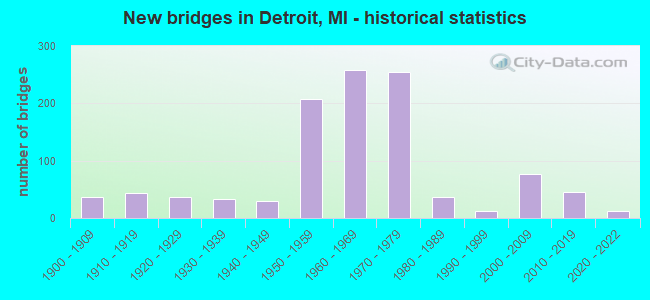
- New bridges - historical statistics
- 1Before 1900
- 371900-1909
- 431910-1919
- 371920-1929
- 331930-1939
- 291940-1949
- 2071950-1959
- 2591960-1969
- 2551970-1979
- 361980-1989
- 131990-1999
- 762000-2009
- 462010-2019
- 132020-2022
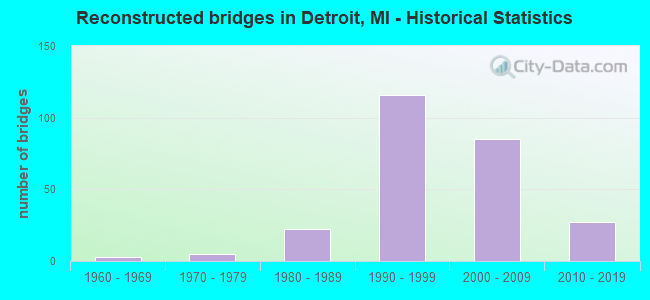
- Reconstructed bridges - Historical Statistics
- 31960-1969
- 51970-1979
- 221980-1989
- 1161990-1999
- 852000-2009
- 272010-2019
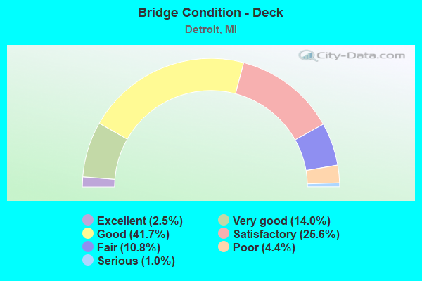
- Bridge Condition - Deck
- 2.5%Excellent
- 14.0%Very good
- 41.7%Good
- 25.6%Satisfactory
- 10.8%Fair
- 4.4%Poor
- 1.0%Serious
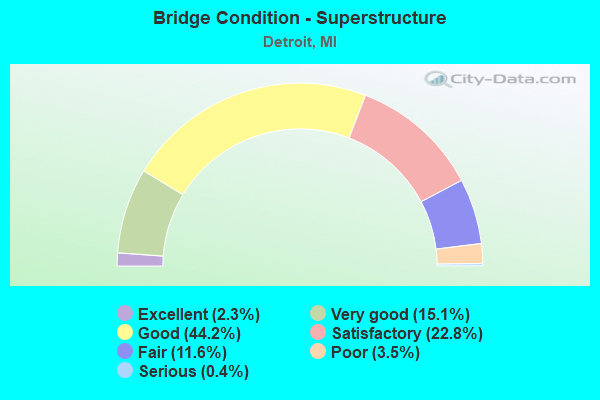
- Bridge Condition - Superstructure
- 2.3%Excellent
- 15.1%Very good
- 44.2%Good
- 22.8%Satisfactory
- 11.6%Fair
- 3.5%Poor
- 0.4%Serious
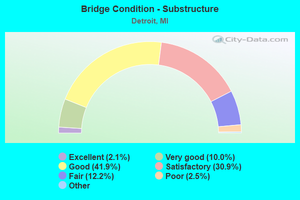
- Bridge Condition - Substructure
- 2.1%Excellent
- 10.0%Very good
- 41.9%Good
- 30.9%Satisfactory
- 12.2%Fair
- 2.5%Poor
- 0.4%Serious
- 0.2%Failed
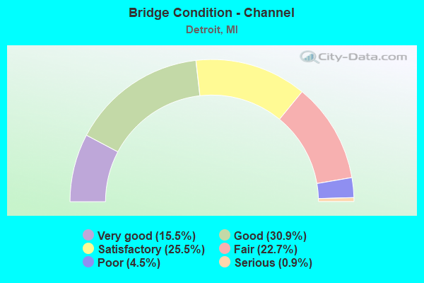
- Bridge Condition - Channel
- 15.5%Very good
- 30.9%Good
- 25.5%Satisfactory
- 22.7%Fair
- 4.5%Poor
- 0.9%Serious
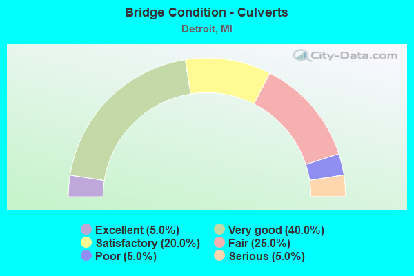
- Bridge Condition - Culverts
- 5.0%Excellent
- 40.0%Very good
- 20.0%Satisfactory
- 25.0%Fair
- 5.0%Poor
- 5.0%Serious
Find on map >> Show street view
Structure Number: 11596, Location: IN DETROIT (Lat: 42.348203, Lng: -83.098417), Route carried "on" structure: Ramp Interstate 96, Year Built: 1971, Year Reconstructed: 2005, Status: Open, Structure Length: 4.51m (14.80ft), Average Daily Traffic: 4,400 (year 2005), Truck Traffic: 3%, Average Future Daily Traffic: 4,800 (year 2025), Design Load: HS 20, Features Intersected: I-96 RAMP, Facility Carried by Structure: WARREN AV EXIT RMP
Minimum Vertical Clearance: 30.48m (100.00ft), Kilometerpoint: 0.172, Lanes on structure: 1, Lanes under structure: 2, Owner: State Highway Agency, Approaching Roadway Width: 5.1m (16.7ft), Skew: 5 degrees, Material/Design: Steel, Design/Construction: Stringer/Multi-beam, Number Of Spans In Main Unit: 2, Length of Maximum Span: 33.9m (111.2ft), Curb-To-Curb Width: 7.3m (24.0ft), Out-to-Out Width: 8.3m (27.2ft)
Condition: Deck: Very good, Superstructure: Good, Substructure: Good, Operating Rating: 76.5 metric tons, Method Used To Determine Operating Rating: Load Factor (LF) rating reported by rating factor (RF) method using MS18 loading, Inventory Rating: 45.7 metric tons, Method Used To Determine Inventory Rating: Load Factor (LF) rating reported by rating factor (RF) method using MS18 loading, Structural Evaluation: Better than present minimum criteria, Deck Geometry: Better than present minimum criteria, Underclear: Meets minimum limits, Approach Roadway Alignment: Equal to present minimum criteria, Designated Inspection Frequency: Every 24 months, Inspection Date: October 2021, Deck Structure Type: Concrete Cast-file-Place, Wearing Surface/Protective System: Wearing Surface: Monolithic Concrete, Deck Protection: Epoxy Coated Reinforcing
Find on map >> Show street view
Structure Number: 11597, Location: IN DETROIT (Lat: 42.348231, Lng: -83.097206), Route carried "on" structure: Ramp Interstate 96, Year Built: 1971, Status: Open, Structure Length: 5.08m (16.67ft), Average Daily Traffic: 4,000 (year 2005), Truck Traffic: 3%, Average Future Daily Traffic: 4,300 (year 2025), Design Load: HS 20+Mod, Features Intersected: I-96 RAMP, Facility Carried by Structure: WARREN AV ENT RAMP
Minimum Vertical Clearance: 30.48m (100.00ft), Kilometerpoint: 0.113, Lanes on structure: 1, Lanes under structure: 2, Owner: State Highway Agency, Approaching Roadway Width: 5.4m (17.7ft), Skew: 5 degrees, Material/Design: Steel, Design/Construction: Stringer/Multi-beam, Number Of Spans In Main Unit: 2, Length of Maximum Span: 39.8m (130.6ft), Curb-To-Curb Width: 7.5m (24.6ft), Out-to-Out Width: 8.4m (27.6ft)
Condition: Deck: Satisfactory, Superstructure: Good, Substructure: Good, Inventory Rating: 61.0 metric tons, Method Used To Determine Inventory Rating: Load Factor (LF), Structural Evaluation: Better than present minimum criteria, Deck Geometry: Better than present minimum criteria, Underclear: High priority of corrective action, Approach Roadway Alignment: Equal to present minimum criteria, Designated Inspection Frequency: Every 24 months, Inspection Date: October 2021, Deck Structure Type: Concrete Cast-file-Place, Wearing Surface/Protective System: Wearing Surface: Latex Concrete
Find on map >> Show street view
Structure Number: 11598, Location: IN DETROIT (Lat: 42.356775, Lng: -83.112114), Route carried "on" structure: City street , Year Built: 1972, Status: Open, Structure Length: 5.39m (17.68ft), Average Daily Traffic: 6,440 (year 1970), Average Future Daily Traffic: 6,440 (year 1977), Design Load: HS 20, Features Intersected: I-96, Facility Carried by Structure: SCOTTEN AVE
Minimum Vertical Clearance: 30.48m (100.00ft), Kilometerpoint: 1.077, Lanes on structure: 4, Lanes under structure: 8, Owner: State Highway Agency, Approaching Roadway Width: 14.6m (47.9ft), Material/Design: Steel, Design/Construction: Stringer/Multi-beam, Number Of Spans In Main Unit: 2, Length of Maximum Span: 27.1m (88.9ft), Curb or Sidewalk Widths: Left: 2.4m (7.9ft), Right: 2.4m (7.9ft), Curb-To-Curb Width: 14.6m (47.9ft), Out-to-Out Width: 20.2m (66.3ft)
Condition: Deck: Fair, Superstructure: Good, Substructure: Fair, Operating Rating: 58.3 metric tons, Method Used To Determine Operating Rating: Load Factor (LF) rating reported by rating factor (RF) method using MS18 loading, Inventory Rating: 35.0 metric tons, Method Used To Determine Inventory Rating: Load Factor (LF) rating reported by rating factor (RF) method using MS18 loading, Structural Evaluation: Somewhat better than minimum adequacy, Deck Geometry: High priority of replacement, Underclear: High priority of corrective action, Approach Roadway Alignment: Equal to present minimum criteria, Designated Inspection Frequency: Every 24 months, Inspection Date: September 2021, Deck Structure Type: Concrete Cast-file-Place, Wearing Surface/Protective System: Wearing Surface: Latex Concrete
Find on map >> Show street view
Structure Number: 11599, Location: IN DETROIT (Lat: 42.385886, Lng: -83.155772), Route carried "on" structure: State highway 8, Year Built: 1971, Status: Temporarily open, Structure Length: 3.72m (12.20ft), Average Daily Traffic: 77,500 (year 1995), Truck Traffic: 5%, Average Future Daily Traffic: 51,381 (year 2015), Design Load: HS 20, Features Intersected: I-96 WYOMING EXIT RAMP
Minimum Vertical Clearance: 30.48m (100.00ft), Kilometerpoint: 0.267, Lanes on structure: 2, Lanes under structure: 1, Base Highway Network: Yes (Inventory Route: 470, Subroute: 77), Owner: State Highway Agency, Approaching Roadway Width: 8.5m (27.9ft), Skew: 6 degrees, Material/Design: Steel, Design/Construction: Stringer/Multi-beam, Number Of Spans In Main Unit: 1, Length of Maximum Span: 37.2m (122.0ft), Curb or Sidewalk Widths: Left: 0.2m (0.7ft), Right: 1.2m (3.9ft), Curb-To-Curb Width: 8.8m (28.9ft), Out-to-Out Width: 10.7m (35.1ft)
Condition: Deck: Fair, Superstructure: Satisfactory, Substructure: Fair, Structural Evaluation: High priority of corrective action, Deck Geometry: High priority of replacement, Underclear: High priority of corrective action, Approach Roadway Alignment: Equal to present desirable criteria, Designated Inspection Frequency: Every 24 months, Other Special Inspection Frequency: Every 24 months, Inspection Date: September 2020, Other Special Inspection Date: September 2021, Deck Structure Type: Concrete Cast-file-Place, Wearing Surface/Protective System: Wearing Surface: Monolithic Concrete
Find on map >> Show street view
Structure Number: 11606, Location: IN DETROIT (Lat: 42.346469, Lng: -83.096447), Route carried "on" structure: City street 2000, Year Built: 1971, Year Reconstructed: 2005, Status: Open, Structure Length: 7.81m (25.62ft), Average Daily Traffic: 24,000 (year 1970), Average Future Daily Traffic: 24,000 (year 1977), Design Load: HS 20, Features Intersected: I-96, Facility Carried by Structure: WARREN AVE
Minimum Vertical Clearance: 30.48m (100.00ft), Kilometerpoint: 8.229, Lanes on structure: 5, Lanes under structure: 10, Owner: State Highway Agency, Approaching Roadway Width: 24.7m (81.0ft), Material/Design: Prestressed concrete, Design/Construction: Box Beam or Girders - Single/Spread, Number Of Spans In Main Unit: 4, Length of Maximum Span: 31.9m (104.7ft), Curb or Sidewalk Widths: Left: 3.0m (9.8ft), Right: 3.0m (9.8ft), Curb-To-Curb Width: 24.7m (81.0ft), Out-to-Out Width: 31.5m (103.3ft)
Condition: Deck: Good, Superstructure: Good, Substructure: Good, Operating Rating: 97.2 metric tons, Method Used To Determine Operating Rating: Load Factor (LF) rating reported by rating factor (RF) method using MS18 loading, Inventory Rating: 46.7 metric tons, Method Used To Determine Inventory Rating: Load Factor (LF) rating reported by rating factor (RF) method using MS18 loading, Structural Evaluation: Better than present minimum criteria, Deck Geometry: Superior to present desirable criteria, Underclear: Meets minimum limits, Approach Roadway Alignment: Equal to present desirable criteria, Designated Inspection Frequency: Every 24 months, Inspection Date: October 2021, Deck Structure Type: Concrete Cast-file-Place, Wearing Surface/Protective System: Wearing Surface: Monolithic Concrete, Deck Protection: Epoxy Coated Reinforcing
Find on map >> Show street view
Structure Number: 11607, Location: IN DETROIT (Lat: 42.342117, Lng: -83.094028), Route carried "on" structure: City street , Year Built: 1971, Year Reconstructed: 1992, Status: Open, Structure Length: 7.22m (23.69ft), Average Daily Traffic: 1,139 (year 2010), Average Future Daily Traffic: 1,253 (year 2025), Design Load: HS 20, Features Intersected: I-96, Facility Carried by Structure: BUCHANAN ST
Minimum Vertical Clearance: 30.48m (100.00ft), Kilometerpoint: 1.075, Lanes on structure: 4, Lanes under structure: 10, Owner: State Highway Agency, Approaching Roadway Width: 14.6m (47.9ft), Material/Design: Steel, Design/Construction: Stringer/Multi-beam, Number Of Spans In Main Unit: 4, Length of Maximum Span: 27.1m (88.9ft), Curb or Sidewalk Widths: Left: 2.4m (7.9ft), Right: 2.4m (7.9ft), Curb-To-Curb Width: 14.6m (47.9ft), Out-to-Out Width: 20.2m (66.3ft)
Condition: Deck: Satisfactory, Superstructure: Good, Substructure: Satisfactory, Operating Rating: 62.2 metric tons, Method Used To Determine Operating Rating: Load Factor (LF) rating reported by rating factor (RF) method using MS18 loading, Inventory Rating: 37.3 metric tons, Method Used To Determine Inventory Rating: Load Factor (LF) rating reported by rating factor (RF) method using MS18 loading, Structural Evaluation: Equal to present minimum criteria, Deck Geometry: High priority of replacement, Underclear: High priority of corrective action, Approach Roadway Alignment: Equal to present desirable criteria, Designated Inspection Frequency: Every 24 months, Inspection Date: October 2021, Bridge Improvement Cost: $404,000, Deck Structure Type: Concrete Cast-file-Place, Wearing Surface/Protective System: Wearing Surface: Monolithic Concrete, Deck Protection: Epoxy Coated Reinforcing
Find on map >> Show street view
Structure Number: 11608, Location: IN DETROIT (Lat: 42.336164, Lng: -83.090425), Route carried "on" structure: City street , Year Built: 1971, Status: Open, Structure Length: 5.30m (17.39ft), Average Daily Traffic: 16,500 (year 1988), Average Future Daily Traffic: 18,975 (year 2008), Design Load: HS 20, Features Intersected: I-96, Facility Carried by Structure: ML KING JR BLVD
Minimum Vertical Clearance: 30.48m (100.00ft), Kilometerpoint: 0.560, Lanes on structure: 6, Lanes under structure: 8, Owner: State Highway Agency, Approaching Roadway Width: 28.6m (93.8ft), Skew: 30 degrees, Material/Design: Steel, Design/Construction: Stringer/Multi-beam, Number Of Spans In Main Unit: 2, Length of Maximum Span: 26.5m (86.9ft), Curb or Sidewalk Widths: Left: 3.0m (9.8ft), Right: 3.0m (9.8ft), Curb-To-Curb Width: 28.6m (93.8ft), Out-to-Out Width: 35.4m (116.1ft)
Condition: Deck: Satisfactory, Superstructure: Good, Substructure: Satisfactory, Operating Rating: 62.9 metric tons, Method Used To Determine Operating Rating: Load Factor (LF) rating reported by rating factor (RF) method using MS18 loading, Inventory Rating: 37.6 metric tons, Method Used To Determine Inventory Rating: Load Factor (LF) rating reported by rating factor (RF) method using MS18 loading, Structural Evaluation: Equal to present minimum criteria, Deck Geometry: Superior to present desirable criteria, Underclear: High priority of corrective action, Approach Roadway Alignment: Equal to present desirable criteria, Designated Inspection Frequency: Every 24 months, Inspection Date: October 2021, Deck Structure Type: Concrete Cast-file-Place, Wearing Surface/Protective System: Wearing Surface: Monolithic Concrete, Deck Protection: Epoxy Coated Reinforcing
Find on map >> Show street view
Structure Number: 11619, Location: 0.1 MI W OF US-24 (Lat: 42.442683, Lng: -83.281314), Route carried "on" structure: State highway 102, Year Built: 1931, Year Reconstructed: 1987, Status: Open, Structure Length: 2.13m (6.99ft), Average Daily Traffic: 25,704 (year 2007), Truck Traffic: 4%, Average Future Daily Traffic: 24,462 (year 2018), Design Load: HS 20+Mod, Features Intersected: ROUGE RIVER
Minimum Vertical Clearance: 30.48m (100.00ft), Kilometerpoint: 3.282, Lanes on structure: 5, Base Highway Network: Yes (Inventory Route: 181, Subroute: 6), Owner: State Highway Agency, Approaching Roadway Width: 12.2m (40.0ft), Material/Design: Prestressed concrete, Design/Construction: Stringer/Multi-beam, Number Of Spans In Main Unit: 1, Length of Maximum Span: 21.3m (69.9ft), Curb-To-Curb Width: 21.0m (68.9ft), Out-to-Out Width: 22.1m (72.5ft)
Condition: Deck: Good, Superstructure: Good, Substructure: Satisfactory, Channel: Satisfactory, Operating Rating: 73.9 metric tons, Method Used To Determine Operating Rating: Load Factor (LF) rating reported by rating factor (RF) method using MS18 loading, Inventory Rating: 29.2 metric tons, Method Used To Determine Inventory Rating: Load Factor (LF) rating reported by rating factor (RF) method using MS18 loading, Structural Evaluation: Equal to present minimum criteria, Deck Geometry: Somewhat better than minimum adequacy, Waterway Adequacy: Equal to present desirable criteria, Approach Roadway Alignment: Equal to present desirable criteria, Designated Inspection Frequency: Every 24 months, Inspection Date: September 2020, Deck Structure Type: Concrete Cast-file-Place, Wearing Surface/Protective System: Wearing Surface: Epoxy Overlay
Find on map >> Show street view
Structure Number: 1162, Location: 0.1 MI W OF US-24 (Lat: 42.442942, Lng: -83.281422), Route carried "on" structure: State highway 102, Year Built: 1987, Status: Open, Structure Length: 2.13m (6.99ft), Average Daily Traffic: 25,704 (year 2007), Truck Traffic: 4%, Average Future Daily Traffic: 24,462 (year 2018), Design Load: HS 25 or greater, Features Intersected: ROUGE RIVER
Minimum Vertical Clearance: 30.48m (100.00ft), Kilometerpoint: 3.304, Lanes on structure: 5, Base Highway Network: Yes (Inventory Route: 64, Subroute: 7), Owner: State Highway Agency, Approaching Roadway Width: 12.2m (40.0ft), Material/Design: Prestressed concrete, Design/Construction: Stringer/Multi-beam, Number Of Spans In Main Unit: 1, Length of Maximum Span: 20.5m (67.3ft), Curb-To-Curb Width: 21.0m (68.9ft), Out-to-Out Width: 22.1m (72.5ft)
Condition: Deck: Good, Superstructure: Good, Substructure: Good, Channel: Satisfactory, Operating Rating: 75.8 metric tons, Method Used To Determine Operating Rating: Load Factor (LF) rating reported by rating factor (RF) method using MS18 loading, Inventory Rating: 31.8 metric tons, Method Used To Determine Inventory Rating: Load Factor (LF) rating reported by rating factor (RF) method using MS18 loading, Structural Evaluation: Better than present minimum criteria, Deck Geometry: Somewhat better than minimum adequacy, Waterway Adequacy: Equal to present desirable criteria, Approach Roadway Alignment: Equal to present desirable criteria, Designated Inspection Frequency: Every 24 months, Inspection Date: September 2020, Deck Structure Type: Concrete Cast-file-Place, Wearing Surface/Protective System: Wearing Surface: Epoxy Overlay, Deck Protection: Epoxy Coated Reinforcing
Find on map >> Show street view
Structure Number: 11621, Location: 0.5 MI E OF US-24 (Lat: 42.442947, Lng: -83.270164), Route carried "on" structure: State highway 102, Year Built: 2013, Status: Open, Structure Length: 2.29m (7.51ft), Average Daily Traffic: 70,214 (year 2007), Truck Traffic: 4%, Average Future Daily Traffic: 26,883 (year 2024), Design Load: Greater than HL93, Features Intersected: PLUM CREEK
Minimum Vertical Clearance: 30+ m (98+ ft), Kilometerpoint: 4.199, Lanes on structure: 4, Base Highway Network: Yes (Inventory Route: 181, Subroute: 6), Owner: State Highway Agency, Approaching Roadway Width: 15.8m (51.8ft), Skew: 24 degrees, Material/Design: Prestressed concrete, Design/Construction: Box Beam or Girders - Single/Spread, Number Of Spans In Main Unit: 1, Length of Maximum Span: 20.3m (66.6ft), Curb or Sidewalk Widths: Left: 0.0m, Right: 1.8m (5.9ft), Curb-To-Curb Width: 15.8m (51.8ft), Out-to-Out Width: 18.9m (62.0ft)
Condition: Deck: Good, Superstructure: Very good, Substructure: Very good, Channel: Good, Operating Rating: 50.9 metric tons, Method Used To Determine Operating Rating: Load and Resistance Factor Rating (LRFR) rating reported by rating factor(RF) method using HL-93 loadings, Inventory Rating: 39.2 metric tons, Method Used To Determine Inventory Rating: Load and Resistance Factor Rating (LRFR) rating reported by rating factor(RF) method using HL-93 loadings, Structural Evaluation: Equal to present desirable criteria, Deck Geometry: Meets minimum limits, Waterway Adequacy: Equal to present desirable criteria, Approach Roadway Alignment: Equal to present desirable criteria, Designated Inspection Frequency: Every 24 months, Inspection Date: September 2020, Deck Structure Type: Concrete Cast-file-Place, Wearing Surface/Protective System: Wearing Surface: Monolithic Concrete, Deck Protection: Epoxy Coated Reinforcing
Find on map >> Show street view
Structure Number: 11622, Location: @ US-24, TELEGRAPH RD (Lat: 42.442739, Lng: -83.278297), Route carried "on" structure: State highway 102, Year Built: 1967, Year Reconstructed: 2002, Status: Open, Structure Length: 6.87m (22.54ft), Average Daily Traffic: 35,107 (year 2007), Truck Traffic: 3%, Average Future Daily Traffic: 30,890 (year 2018), Design Load: HS 25 or greater, Features Intersected: US-24
Minimum Vertical Clearance: 30.48m (100.00ft), Kilometerpoint: 3.529, Lanes on structure: 5, Lanes under structure: 10, Base Highway Network: Yes (Inventory Route: 181, Subroute: 6), Owner: State Highway Agency, Approaching Roadway Width: 30.4m (99.7ft), Skew: 11 degrees, Material/Design: Prestressed concrete, Design/Construction: Box Beam or Girders - Single/Spread, Number Of Spans In Main Unit: 4, Length of Maximum Span: 24.8m (81.4ft), Curb-To-Curb Width: 21.4m (70.2ft), Out-to-Out Width: 22.4m (73.5ft)
Condition: Deck: Good, Superstructure: Good, Substructure: Satisfactory, Operating Rating: 59.9 metric tons, Method Used To Determine Operating Rating: Load Factor (LF) rating reported by rating factor (RF) method using MS18 loading, Inventory Rating: 45.0 metric tons, Method Used To Determine Inventory Rating: Load Factor (LF) rating reported by rating factor (RF) method using MS18 loading, Structural Evaluation: Equal to present minimum criteria, Deck Geometry: Somewhat better than minimum adequacy, Underclear: Meets minimum limits, Approach Roadway Alignment: Equal to present desirable criteria, Designated Inspection Frequency: Every 24 months, Inspection Date: November 2021, Deck Structure Type: Concrete Cast-file-Place, Wearing Surface/Protective System: Wearing Surface: Monolithic Concrete, Deck Protection: Epoxy Coated Reinforcing
Find on map >> Show street view
Structure Number: 11623, Location: @ US-24, TELEGRAPH RD (Lat: 42.443003, Lng: -83.278222), Route carried "on" structure: State highway 102, Year Built: 1967, Year Reconstructed: 2002, Status: Open, Structure Length: 6.87m (22.54ft), Average Daily Traffic: 39,603 (year 2007), Truck Traffic: 3%, Average Future Daily Traffic: 33,298 (year 2018), Design Load: HS 25 or greater, Features Intersected: US-24
Minimum Vertical Clearance: 30.48m (100.00ft), Kilometerpoint: 3.566, Lanes on structure: 5, Lanes under structure: 10, Base Highway Network: Yes (Inventory Route: 64, Subroute: 7), Owner: State Highway Agency, Approaching Roadway Width: 30.4m (99.7ft), Skew: 11 degrees, Material/Design: Prestressed concrete, Design/Construction: Box Beam or Girders - Single/Spread, Number Of Spans In Main Unit: 4, Length of Maximum Span: 24.8m (81.4ft), Curb or Sidewalk Widths: Left: 0.9m (3.0ft), Right: 2.4m (7.9ft), Curb-To-Curb Width: 21.4m (70.2ft), Out-to-Out Width: 22.4m (73.5ft)
Condition: Deck: Good, Superstructure: Good, Substructure: Satisfactory, Operating Rating: 66.1 metric tons, Method Used To Determine Operating Rating: Load Factor (LF) rating reported by rating factor (RF) method using MS18 loading, Inventory Rating: 48.0 metric tons, Method Used To Determine Inventory Rating: Load Factor (LF) rating reported by rating factor (RF) method using MS18 loading, Structural Evaluation: Equal to present minimum criteria, Deck Geometry: Somewhat better than minimum adequacy, Underclear: Meets minimum limits, Approach Roadway Alignment: Equal to present desirable criteria, Designated Inspection Frequency: Every 24 months, Inspection Date: November 2021, Deck Structure Type: Concrete Cast-file-Place, Wearing Surface/Protective System: Wearing Surface: Monolithic Concrete, Deck Protection: Epoxy Coated Reinforcing
Find on map >> Show street view
Structure Number: 11687, Location: IN DETROIT (Lat: 42.336133, Lng: -83.215753), Route carried "on" structure: City street , Year Built: 2005, Status: Open, Structure Length: 3.90m (12.80ft), Average Daily Traffic: 5,410 (year 2005), Truck Traffic: 4%, Average Future Daily Traffic: 5,885 (year 2025), Design Load: HS 20, Features Intersected: M-39, Facility Carried by Structure: PAUL AVE
Minimum Vertical Clearance: 30.48m (100.00ft), Kilometerpoint: 1.798, Lanes on structure: 4, Lanes under structure: 6, Owner: State Highway Agency, Approaching Roadway Width: 15.8m (51.8ft), Material/Design: Prestressed concrete, Design/Construction: Box Beam or Girders - Single/Spread, Number Of Spans In Main Unit: 2, Length of Maximum Span: 19.5m (64.0ft), Curb or Sidewalk Widths: Left: 1.6m (5.2ft), Right: 1.6m (5.2ft), Curb-To-Curb Width: 15.8m (51.8ft), Out-to-Out Width: 19.7m (64.6ft)
Condition: Deck: Very good, Superstructure: Very good, Substructure: Good, Operating Rating: 55.4 metric tons, Method Used To Determine Operating Rating: Load and Resistance Factor Rating (LRFR) rating reported by rating factor(RF) method using HL-93 loadings, Inventory Rating: 29.8 metric tons, Method Used To Determine Inventory Rating: Load and Resistance Factor Rating (LRFR) rating reported by rating factor(RF) method using HL-93 loadings, Structural Evaluation: Better than present minimum criteria, Deck Geometry: Meets minimum limits, Underclear: High priority of corrective action, Approach Roadway Alignment: Equal to present desirable criteria, Designated Inspection Frequency: Every 24 months, Inspection Date: May 2020, Deck Structure Type: Concrete Cast-file-Place, Wearing Surface/Protective System: Wearing Surface: Integral Concrete, Deck Protection: Epoxy Coated Reinforcing
Find on map >> Show street view
Structure Number: 11688, Location: IN DETROIT (Lat: 42.343372, Lng: -83.216039), Route carried "on" structure: County highway 2057, Year Built: 1961, Year Reconstructed: 2005, Status: Open, Structure Length: 3.31m (10.86ft), Average Daily Traffic: 31,520 (year 2005), Average Future Daily Traffic: 38,600 (year 2025), Design Load: HS 20+Mod, Features Intersected: M-39, Facility Carried by Structure: WARREN AVE
Minimum Vertical Clearance: 30.48m (100.00ft), Kilometerpoint: 3.816, Lanes on structure: 8, Lanes under structure: 6, Base Highway Network: Yes (Inventory Route: 159, Subroute: 4), Owner: State Highway Agency, Approaching Roadway Width: 18.9m (62.0ft), Material/Design: Prestressed concrete, Design/Construction: Box Beam or Girders - Single/Spread, Number Of Spans In Main Unit: 2, Length of Maximum Span: 16.6m (54.5ft), Curb or Sidewalk Widths: Left: 3.0m (9.8ft), Right: 3.0m (9.8ft), Curb-To-Curb Width: 22.2m (72.8ft), Out-to-Out Width: 41.2m (135.2ft)
Condition: Deck: Very good, Superstructure: Good, Substructure: Good, Operating Rating: 50.2 metric tons, Method Used To Determine Operating Rating: Load and Resistance Factor Rating (LRFR) rating reported by rating factor(RF) method using HL-93 loadings, Inventory Rating: 38.6 metric tons, Method Used To Determine Inventory Rating: Load and Resistance Factor Rating (LRFR) rating reported by rating factor(RF) method using HL-93 loadings, Structural Evaluation: Better than present minimum criteria, Deck Geometry: High priority of replacement, Underclear: High priority of corrective action, Approach Roadway Alignment: Equal to present desirable criteria, Designated Inspection Frequency: Every 24 months, Inspection Date: May 2020, Deck Structure Type: Concrete Cast-file-Place, Wearing Surface/Protective System: Wearing Surface: Monolithic Concrete, Deck Protection: Epoxy Coated Reinforcing
Find on map >> Show street view
Structure Number: 11689, Location: IN DETROIT (Lat: 42.350619, Lng: -83.216261), Route carried "on" structure: City street , Year Built: 2005, Status: Open, Structure Length: 3.93m (12.89ft), Average Daily Traffic: 6,630 (year 2005), Truck Traffic: 3%, Average Future Daily Traffic: 10,350 (year 2025), Design Load: HS 20+Mod, Features Intersected: M-39, Facility Carried by Structure: TIREMAN AVE
Minimum Vertical Clearance: 30.48m (100.00ft), Kilometerpoint: 2.561, Lanes on structure: 4, Lanes under structure: 6, Owner: State Highway Agency, Approaching Roadway Width: 13.4m (44.0ft), Material/Design: Prestressed concrete, Design/Construction: Box Beam or Girders - Single/Spread, Number Of Spans In Main Unit: 2, Length of Maximum Span: 19.5m (64.0ft), Curb or Sidewalk Widths: Left: 1.9m (6.2ft), Right: 1.9m (6.2ft), Curb-To-Curb Width: 13.4m (44.0ft), Out-to-Out Width: 17.2m (56.4ft)
Condition: Deck: Good, Superstructure: Good, Substructure: Good, Operating Rating: 74.8 metric tons, Method Used To Determine Operating Rating: Load Factor (LF) rating reported by rating factor (RF) method using MS18 loading, Inventory Rating: 33.7 metric tons, Method Used To Determine Inventory Rating: Load Factor (LF) rating reported by rating factor (RF) method using MS18 loading, Structural Evaluation: Better than present minimum criteria, Deck Geometry: High priority of replacement, Underclear: High priority of corrective action, Approach Roadway Alignment: Better than present minimum criteria, Designated Inspection Frequency: Every 24 months, Inspection Date: May 2020, Deck Structure Type: Concrete Cast-file-Place, Wearing Surface/Protective System: Wearing Surface: Integral Concrete, Deck Protection: Epoxy Coated Reinforcing
Find on map >> Show street view
Structure Number: 1169, Location: IN DETROIT (Lat: 42.357850, Lng: -83.216392), Route carried "on" structure: County highway 2057, Year Built: 1962, Year Reconstructed: 2010, Status: Open, Structure Length: 3.32m (10.89ft), Average Daily Traffic: 19,000 (year 2008), Truck Traffic: 3%, Average Future Daily Traffic: 22,500 (year 2029), Design Load: Greater than HL93, Features Intersected: M-39, Facility Carried by Structure: JOY RD
Minimum Vertical Clearance: 30.48m (100.00ft), Kilometerpoint: 12.835, Lanes on structure: 8, Lanes under structure: 6, Owner: State Highway Agency, Approaching Roadway Width: 30.4m (99.7ft), Skew: 20 degrees, Material/Design: Prestressed concrete, Design/Construction: Box Beam or Girders - Single/Spread, Number Of Spans In Main Unit: 2, Length of Maximum Span: 15.9m (52.2ft), Curb or Sidewalk Widths: Left: 2.5m (8.2ft), Right: 2.5m (8.2ft), Curb-To-Curb Width: 35.4m (116.1ft), Out-to-Out Width: 41.2m (135.2ft)
Condition: Deck: Very good, Superstructure: Very good, Substructure: Very good, Operating Rating: 57.0 metric tons, Method Used To Determine Operating Rating: Load and Resistance Factor Rating (LRFR) rating reported by rating factor(RF) method using HL-93 loadings, Inventory Rating: 44.1 metric tons, Method Used To Determine Inventory Rating: Load and Resistance Factor Rating (LRFR) rating reported by rating factor(RF) method using HL-93 loadings, Structural Evaluation: Equal to present desirable criteria, Deck Geometry: Superior to present desirable criteria, Underclear: High priority of corrective action, Approach Roadway Alignment: Equal to present desirable criteria, Designated Inspection Frequency: Every 24 months, Inspection Date: December 2021, Deck Structure Type: Concrete Cast-file-Place, Wearing Surface/Protective System: Wearing Surface: Monolithic Concrete, Deck Protection: Epoxy Coated Reinforcing
Find on map >> Show street view
Structure Number: 11691, Location: IN DETROIT (Lat: 42.364183, Lng: -83.216364), Route carried "on" structure: City street , Year Built: 1963, Year Reconstructed: 2010, Status: Open, Structure Length: 3.06m (10.04ft), Average Daily Traffic: 2,270 (year 0000), Average Future Daily Traffic: 2,300 (year 2029), Design Load: HS 20+Mod, Features Intersected: M-39, Facility Carried by Structure: FITZPATRICK AVE
Minimum Vertical Clearance: 30.48m (100.00ft), Kilometerpoint: 0.023, Lanes on structure: 2, Lanes under structure: 6, Owner: State Highway Agency, Approaching Roadway Width: 9.6m (31.5ft), Material/Design: Steel continuous, Design/Construction: Stringer/Multi-beam, Number Of Spans In Main Unit: 2, Length of Maximum Span: 16.2m (53.1ft), Curb or Sidewalk Widths: Left: 1.9m (6.2ft), Right: 0.0m, Curb-To-Curb Width: 9.7m (31.8ft), Out-to-Out Width: 12.4m (40.7ft)
Condition: Deck: Good, Superstructure: Satisfactory, Substructure: Very good, Operating Rating: 76.8 metric tons, Method Used To Determine Operating Rating: Load Factor (LF), Inventory Rating: 46.1 metric tons, Method Used To Determine Inventory Rating: Load Factor (LF), Structural Evaluation: Equal to present minimum criteria, Deck Geometry: Meets minimum limits, Underclear: High priority of corrective action, Approach Roadway Alignment: Somewhat better than minimum adequacy, Designated Inspection Frequency: Every 24 months, Inspection Date: December 2021, Deck Structure Type: Concrete Cast-file-Place, Wearing Surface/Protective System: Wearing Surface: Monolithic Concrete, Deck Protection: Epoxy Coated Reinforcing
Find on map >> Show street view
Structure Number: 11692, Location: IN DETROIT (Lat: 42.365258, Lng: -83.216378), Route carried "on" structure: City street , Year Built: 1963, Year Reconstructed: 2010, Status: Open, Structure Length: 3.31m (10.86ft), Average Daily Traffic: 7,200 (year 2008), Truck Traffic: 3%, Average Future Daily Traffic: 7,900 (year 2029), Design Load: HS 20+Mod, Features Intersected: M-39, Facility Carried by Structure: W CHICAGO AVE
Minimum Vertical Clearance: 30.48m (100.00ft), Kilometerpoint: 2.683, Lanes on structure: 5, Lanes under structure: 6, Owner: State Highway Agency, Approaching Roadway Width: 20.1m (65.9ft), Material/Design: Steel continuous, Design/Construction: Stringer/Multi-beam, Number Of Spans In Main Unit: 2, Length of Maximum Span: 16.2m (53.1ft), Curb or Sidewalk Widths: Left: 2.3m (7.5ft), Right: 3.0m (9.8ft), Curb-To-Curb Width: 20.1m (65.9ft), Out-to-Out Width: 26.2m (86.0ft)
Condition: Deck: Good, Superstructure: Very good, Substructure: Very good, Operating Rating: 58.5 metric tons, Method Used To Determine Operating Rating: Load Factor (LF), Inventory Rating: 35.1 metric tons, Method Used To Determine Inventory Rating: Load Factor (LF), Structural Evaluation: Equal to present desirable criteria, Deck Geometry: Somewhat better than minimum adequacy, Underclear: High priority of corrective action, Approach Roadway Alignment: Equal to present desirable criteria, Designated Inspection Frequency: Every 24 months, Inspection Date: December 2021, Deck Structure Type: Concrete Cast-file-Place, Wearing Surface/Protective System: Wearing Surface: Monolithic Concrete, Deck Protection: Epoxy Coated Reinforcing
Find on map >> Show street view
Structure Number: 11693, Location: IN DETROIT (Lat: 42.372258, Lng: -83.216581), Route carried "on" structure: County highway , Year Built: 1961, Year Reconstructed: 2010, Status: Open, Structure Length: 3.31m (10.86ft), Average Daily Traffic: 34,400 (year 1978), Truck Traffic: 3%, Average Future Daily Traffic: 17,800 (year 2029), Design Load: HS 20+Mod, Features Intersected: M-39 (SOUTHFIELD), Facility Carried by Structure: PLYMOUTH ROAD
Minimum Vertical Clearance: 30.48m (100.00ft), Kilometerpoint: 27.846, Lanes on structure: 10, Lanes under structure: 6, Base Highway Network: Yes (Inventory Route: 160, Subroute: 2), Owner: State Highway Agency, Approaching Roadway Width: 30.4m (99.7ft), Material/Design: Steel continuous, Design/Construction: Stringer/Multi-beam, Number Of Spans In Main Unit: 2, Length of Maximum Span: 16.2m (53.1ft), Curb or Sidewalk Widths: Left: 2.3m (7.5ft), Right: 2.3m (7.5ft), Curb-To-Curb Width: 38.4m (126.0ft), Out-to-Out Width: 43.8m (143.7ft)
Condition: Deck: Very good, Superstructure: Good, Substructure: Very good, Operating Rating: 58.2 metric tons, Method Used To Determine Operating Rating: Load Factor (LF), Inventory Rating: 34.9 metric tons, Method Used To Determine Inventory Rating: Load Factor (LF), Structural Evaluation: Better than present minimum criteria, Deck Geometry: Somewhat better than minimum adequacy, Underclear: High priority of corrective action, Approach Roadway Alignment: Equal to present desirable criteria, Designated Inspection Frequency: Every 24 months, Inspection Date: December 2021, Deck Structure Type: Concrete Cast-file-Place, Wearing Surface/Protective System: Wearing Surface: Monolithic Concrete, Deck Protection: Epoxy Coated Reinforcing
Find on map >> Show street view
Structure Number: 11694, Location: IN DETROIT (Lat: 42.379703, Lng: -83.216900), Route carried "on" structure: City street , Year Built: 1964, Year Reconstructed: 2010, Status: Open, Structure Length: 5.08m (16.67ft), Average Daily Traffic: 1,500 (year 2008), Truck Traffic: 3%, Average Future Daily Traffic: 1,700 (year 2035), Design Load: HS 20+Mod, Features Intersected: M-39, Facility Carried by Structure: EB FULLERTON AVE
Minimum Vertical Clearance: 30.48m (100.00ft), Kilometerpoint: 0.069, Lanes on structure: 1, Lanes under structure: 8, Owner: State Highway Agency, Approaching Roadway Width: 12.3m (40.4ft), Material/Design: Prestressed concrete, Design/Construction: Stringer/Multi-beam, Number Of Spans In Main Unit: 4, Length of Maximum Span: 16.1m (52.8ft), Curb or Sidewalk Widths: Left: 1.8m (5.9ft), Right: 0.0m, Curb-To-Curb Width: 14.1m (46.3ft), Out-to-Out Width: 16.7m (54.8ft)
Condition: Deck: Very good, Superstructure: Good, Substructure: Good, Operating Rating: 62.4 metric tons, Method Used To Determine Operating Rating: Load Factor (LF), Inventory Rating: 37.3 metric tons, Method Used To Determine Inventory Rating: Load Factor (LF), Structural Evaluation: Better than present minimum criteria, Deck Geometry: Superior to present desirable criteria, Underclear: High priority of corrective action, Approach Roadway Alignment: Equal to present desirable criteria, Designated Inspection Frequency: Every 24 months, Inspection Date: August 2021, Deck Structure Type: Concrete Cast-file-Place, Wearing Surface/Protective System: Wearing Surface: Monolithic Concrete, Deck Protection: Epoxy Coated Reinforcing
Find on map >> Show street view
Structure Number: 11695, Location: IN DETROIT (Lat: 42.386714, Lng: -83.217544), Route carried "on" structure: County highway 2057, Year Built: 1961, Year Reconstructed: 2010, Status: Open, Structure Length: 3.31m (10.86ft), Average Daily Traffic: 30,060 (year 1978), Truck Traffic: 3%, Average Future Daily Traffic: 16,700 (year 2029), Design Load: HS 20+Mod, Features Intersected: M-39, Facility Carried by Structure: SCHOOLCRAFT AVE
Minimum Vertical Clearance: 30.48m (100.00ft), Kilometerpoint: 19.210, Lanes on structure: 8, Lanes under structure: 6, Owner: State Highway Agency, Approaching Roadway Width: 36.0m (118.1ft), Material/Design: Steel continuous, Design/Construction: Stringer/Multi-beam, Number Of Spans In Main Unit: 2, Length of Maximum Span: 16.2m (53.1ft), Curb or Sidewalk Widths: Left: 3.3m (10.8ft), Right: 3.3m (10.8ft), Curb-To-Curb Width: 36.0m (118.1ft), Out-to-Out Width: 42.1m (138.1ft)
Condition: Deck: Good, Superstructure: Good, Substructure: Good, Operating Rating: 62.1 metric tons, Method Used To Determine Operating Rating: Load Factor (LF), Inventory Rating: 37.2 metric tons, Method Used To Determine Inventory Rating: Load Factor (LF), Structural Evaluation: Better than present minimum criteria, Deck Geometry: Superior to present desirable criteria, Underclear: High priority of corrective action, Approach Roadway Alignment: Equal to present desirable criteria, Designated Inspection Frequency: Every 24 months, Inspection Date: September 2020, Deck Structure Type: Concrete Cast-file-Place, Wearing Surface/Protective System: Wearing Surface: Bituminous
Find on map >> Show street view
Structure Number: 11704, Location: IN DETROIT (Lat: 42.393897, Lng: -83.217900), Route carried "on" structure: City street , Year Built: 1961, Year Reconstructed: 2010, Status: Open, Structure Length: 3.36m (11.02ft), Average Daily Traffic: 1,800 (year 2008), Average Future Daily Traffic: 2,000 (year 2029), Design Load: Greater than HL93, Features Intersected: M-39, Facility Carried by Structure: LYNDON AVE
Minimum Vertical Clearance: 30.48m (100.00ft), Kilometerpoint: 3.858, Lanes on structure: 4, Lanes under structure: 6, Owner: State Highway Agency, Approaching Roadway Width: 13.4m (44.0ft), Material/Design: Prestressed concrete, Design/Construction: Box Beam or Girders - Multiple, Number Of Spans In Main Unit: 2, Length of Maximum Span: 16.2m (53.1ft), Curb or Sidewalk Widths: Left: 3.2m (10.5ft), Right: 3.2m (10.5ft), Curb-To-Curb Width: 13.4m (44.0ft), Out-to-Out Width: 20.4m (66.9ft)
Condition: Deck: Good, Superstructure: Good, Substructure: Good, Operating Rating: 86.8 metric tons, Method Used To Determine Operating Rating: Load Factor (LF), Inventory Rating: 51.9 metric tons, Method Used To Determine Inventory Rating: Load Factor (LF), Structural Evaluation: Better than present minimum criteria, Deck Geometry: High priority of replacement, Underclear: High priority of corrective action, Approach Roadway Alignment: Equal to present desirable criteria, Designated Inspection Frequency: Every 24 months, Inspection Date: August 2021, Deck Structure Type: Concrete Cast-file-Place, Wearing Surface/Protective System: Wearing Surface: Monolithic Concrete, Deck Protection: Epoxy Coated Reinforcing
Find on map >> Show street view
Structure Number: 11705, Location: IN DETROIT (Lat: 42.400667, Lng: -83.218197), Route carried "on" structure: State highway 5, Year Built: 1963, Year Reconstructed: 1995, Status: Open, Structure Length: 3.75m (12.30ft), Average Daily Traffic: 19,129 (year 2007), Truck Traffic: 4%, Average Future Daily Traffic: 22,330 (year 2018), Design Load: HS 20+Mod, Features Intersected: M-39 (SOUTHFIELD EXP)
Minimum Vertical Clearance: 30.48m (100.00ft), Kilometerpoint: 4.418, Lanes on structure: 7, Lanes under structure: 6, Base Highway Network: Yes (Inventory Route: 157, Subroute: 8), Owner: State Highway Agency, Approaching Roadway Width: 23.1m (75.8ft), Skew: 2 degrees, Material/Design: Steel continuous, Design/Construction: Stringer/Multi-beam, Number Of Spans In Main Unit: 2, Length of Maximum Span: 18.9m (62.0ft), Curb or Sidewalk Widths: Left: 0.0m, Right: 3.6m (11.8ft), Curb-To-Curb Width: 31.3m (102.7ft), Out-to-Out Width: 35.5m (116.5ft)
Condition: Deck: Good, Superstructure: Satisfactory, Substructure: Satisfactory, Operating Rating: 53.8 metric tons, Method Used To Determine Operating Rating: Load Factor (LF) rating reported by rating factor (RF) method using MS18 loading, Inventory Rating: 32.1 metric tons, Method Used To Determine Inventory Rating: Load Factor (LF) rating reported by rating factor (RF) method using MS18 loading, Structural Evaluation: Equal to present minimum criteria, Deck Geometry: Better than present minimum criteria, Underclear: High priority of corrective action, Approach Roadway Alignment: Equal to present desirable criteria, Designated Inspection Frequency: Every 24 months, Critical Feature Inspection Frequency: Every 15 months, Inspection Date: May 2020, Critical Feature Inspection Date: July 2021, Deck Structure Type: Concrete Cast-file-Place, Wearing Surface/Protective System: Wearing Surface: Monolithic Concrete, Deck Protection: Epoxy Coated Reinforcing
Find on map >> Show street view
Structure Number: 11706, Location: IN DETROIT (Lat: 42.401128, Lng: -83.218197), Route carried "on" structure: County highway 2057, Year Built: 1962, Year Reconstructed: 2010, Status: Open, Structure Length: 3.31m (10.86ft), Average Daily Traffic: 25,000 (year 1978), Truck Traffic: 3%, Average Future Daily Traffic: 1,230 (year 2029), Design Load: HS 20+Mod, Features Intersected: M-39, Facility Carried by Structure: FENKELL AVE
Minimum Vertical Clearance: 30.48m (100.00ft), Kilometerpoint: 7.973, Lanes on structure: 7, Lanes under structure: 6, Owner: State Highway Agency, Approaching Roadway Width: 27.9m (91.5ft), Material/Design: Steel continuous, Design/Construction: Stringer/Multi-beam, Number Of Spans In Main Unit: 2, Length of Maximum Span: 16.2m (53.1ft), Curb or Sidewalk Widths: Left: 2.3m (7.5ft), Right: 0.0m, Curb-To-Curb Width: 27.2m (89.2ft), Out-to-Out Width: 30.2m (99.1ft)
Condition: Deck: Very good, Superstructure: Very good, Substructure: Good, Operating Rating: 58.0 metric tons, Method Used To Determine Operating Rating: Load Factor (LF), Inventory Rating: 34.8 metric tons, Method Used To Determine Inventory Rating: Load Factor (LF), Structural Evaluation: Better than present minimum criteria, Deck Geometry: Somewhat better than minimum adequacy, Underclear: High priority of corrective action, Approach Roadway Alignment: Equal to present desirable criteria, Designated Inspection Frequency: Every 24 months, Inspection Date: November 2021, Deck Structure Type: Concrete Cast-file-Place, Wearing Surface/Protective System: Wearing Surface: Monolithic Concrete, Deck Protection: Epoxy Coated Reinforcing
Find on map >> Show street view
Structure Number: 11707, Location: IN DETROIT (Lat: 42.408333, Lng: -83.218525), Route carried "on" structure: City street , Year Built: 1962, Year Reconstructed: 2010, Status: Open, Structure Length: 4.86m (15.94ft), Average Daily Traffic: 8,500 (year 2008), Truck Traffic: 3%, Average Future Daily Traffic: 13,700 (year 2029), Design Load: HS 20+Mod, Features Intersected: M-39, Facility Carried by Structure: PURITAN AVE
Minimum Vertical Clearance: 30.48m (100.00ft), Kilometerpoint: 0.843, Lanes on structure: 2, Lanes under structure: 6, Owner: State Highway Agency, Approaching Roadway Width: 13.4m (44.0ft), Material/Design: Steel continuous, Design/Construction: Stringer/Multi-beam, Number Of Spans In Main Unit: 4, Length of Maximum Span: 16.2m (53.1ft), Curb or Sidewalk Widths: Left: 3.7m (12.1ft), Right: 3.7m (12.1ft), Curb-To-Curb Width: 13.4m (44.0ft), Out-to-Out Width: 21.4m (70.2ft)
Condition: Deck: Good, Superstructure: Good, Substructure: Good, Operating Rating: 58.1 metric tons, Method Used To Determine Operating Rating: Load Factor (LF), Inventory Rating: 34.8 metric tons, Method Used To Determine Inventory Rating: Load Factor (LF), Structural Evaluation: Better than present minimum criteria, Deck Geometry: Equal to present minimum criteria, Underclear: High priority of corrective action, Approach Roadway Alignment: Equal to present desirable criteria, Designated Inspection Frequency: Every 24 months, Inspection Date: August 2021, Deck Structure Type: Concrete Cast-file-Place, Wearing Surface/Protective System: Wearing Surface: Monolithic Concrete, Deck Protection: Epoxy Coated Reinforcing
Find on map >> Show street view
Structure Number: 11708, Location: IN DETROIT (Lat: 42.415553, Lng: -83.218708), Route carried "on" structure: County highway 2057, Year Built: 1962, Year Reconstructed: 2010, Status: Open, Structure Length: 3.31m (10.86ft), Average Daily Traffic: 20,700 (year 2008), Truck Traffic: 3%, Average Future Daily Traffic: 27,500 (year 2029), Design Load: HS 20+Mod, Features Intersected: M-39, Facility Carried by Structure: 6 MI RD
Minimum Vertical Clearance: 30.48m (100.00ft), Kilometerpoint: 27.361, Lanes on structure: 8, Lanes under structure: 6, Base Highway Network: Yes (Inventory Route: 168, Subroute: 1), Owner: State Highway Agency, Approaching Roadway Width: 30.4m (99.7ft), Material/Design: Steel continuous, Design/Construction: Stringer/Multi-beam, Number Of Spans In Main Unit: 2, Length of Maximum Span: 16.2m (53.1ft), Curb or Sidewalk Widths: Left: 2.8m (9.2ft), Right: 2.8m (9.2ft), Curb-To-Curb Width: 34.7m (113.8ft), Out-to-Out Width: 41.1m (134.8ft)
Condition: Deck: Good, Superstructure: Good, Substructure: Satisfactory, Operating Rating: 56.6 metric tons, Method Used To Determine Operating Rating: Load Factor (LF), Inventory Rating: 33.9 metric tons, Method Used To Determine Inventory Rating: Load Factor (LF), Structural Evaluation: Equal to present minimum criteria, Deck Geometry: Better than present minimum criteria, Underclear: High priority of corrective action, Approach Roadway Alignment: Equal to present desirable criteria, Designated Inspection Frequency: Every 24 months, Inspection Date: August 2021, Deck Structure Type: Concrete Cast-file-Place, Wearing Surface/Protective System: Wearing Surface: Monolithic Concrete, Deck Protection: Epoxy Coated Reinforcing
Find on map >> Show street view
Structure Number: 11709, Location: IN DETROIT (Lat: 42.419075, Lng: -83.218814), Route carried "on" structure: County highway 2057, Year Built: 1963, Year Reconstructed: 1991, Status: Open, Structure Length: 3.31m (10.86ft), Average Daily Traffic: 17,900 (year 2007), Average Future Daily Traffic: 19,690 (year 2022), Design Load: HS 20, Features Intersected: M-39, Facility Carried by Structure: OUTER DRIVE
Minimum Vertical Clearance: 30.48m (100.00ft), Kilometerpoint: 0.916, Lanes on structure: 8, Lanes under structure: 6, Owner: State Highway Agency, Approaching Roadway Width: 33.5m (109.9ft), Skew: 30 degrees, Material/Design: Steel continuous, Design/Construction: Stringer/Multi-beam, Number Of Spans In Main Unit: 2, Length of Maximum Span: 15.8m (51.8ft), Curb or Sidewalk Widths: Left: 3.3m (10.8ft), Right: 3.3m (10.8ft), Curb-To-Curb Width: 29.3m (96.1ft), Out-to-Out Width: 40.8m (133.9ft)
Condition: Deck: Satisfactory, Superstructure: Good, Substructure: Satisfactory, Operating Rating: 71.0 metric tons, Method Used To Determine Operating Rating: Load Factor (LF) rating reported by rating factor (RF) method using MS18 loading, Inventory Rating: 36.9 metric tons, Method Used To Determine Inventory Rating: Load Factor (LF) rating reported by rating factor (RF) method using MS18 loading, Structural Evaluation: Equal to present minimum criteria, Deck Geometry: Meets minimum limits, Underclear: High priority of corrective action, Approach Roadway Alignment: Equal to present desirable criteria, Designated Inspection Frequency: Every 24 months, Inspection Date: May 2020, Deck Structure Type: Concrete Cast-file-Place, Wearing Surface/Protective System: Wearing Surface: Epoxy Overlay, Deck Protection: Epoxy Coated Reinforcing
Find on map >> Show street view
Structure Number: 1171, Location: IN DETROIT (Lat: 42.422786, Lng: -83.218953), Route carried "on" structure: City street , Year Built: 1963, Year Reconstructed: 2010, Status: Open, Structure Length: 3.31m (10.86ft), Average Daily Traffic: 4,600 (year 2008), Truck Traffic: 3%, Average Future Daily Traffic: 5,700 (year 2029), Design Load: Greater than HL93, Features Intersected: M-39, Facility Carried by Structure: CURTIS AVE
Minimum Vertical Clearance: 30.48m (100.00ft), Kilometerpoint: 1.611, Lanes on structure: 2, Lanes under structure: 6, Owner: State Highway Agency, Approaching Roadway Width: 13.4m (44.0ft), Material/Design: Prestressed concrete, Design/Construction: Box Beam or Girders - Single/Spread, Number Of Spans In Main Unit: 2, Length of Maximum Span: 15.9m (52.2ft), Curb or Sidewalk Widths: Left: 3.8m (12.5ft), Right: 3.8m (12.5ft), Curb-To-Curb Width: 13.4m (44.0ft), Out-to-Out Width: 21.8m (71.5ft)
Condition: Deck: Good, Superstructure: Very good, Substructure: Good, Operating Rating: 73.1 metric tons, Method Used To Determine Operating Rating: Load Factor (LF), Inventory Rating: 43.7 metric tons, Method Used To Determine Inventory Rating: Load Factor (LF), Structural Evaluation: Better than present minimum criteria, Deck Geometry: Better than present minimum criteria, Underclear: High priority of corrective action, Approach Roadway Alignment: Equal to present desirable criteria, Designated Inspection Frequency: Every 24 months, Inspection Date: June 2021, Deck Structure Type: Concrete Cast-file-Place, Wearing Surface/Protective System: Wearing Surface: Monolithic Concrete, Deck Protection: Epoxy Coated Reinforcing
Find on map >> Show street view
Structure Number: 11711, Location: IN DETROIT (Lat: 42.430022, Lng: -83.219228), Route carried "on" structure: County highway 2057, Year Built: 1963, Year Reconstructed: 2010, Status: Open, Structure Length: 3.31m (10.86ft), Average Daily Traffic: 30,550 (year 1978), Average Future Daily Traffic: 55,000 (year 2029), Design Load: HS 20, Features Intersected: M-39, Facility Carried by Structure: 7 MI RD
Minimum Vertical Clearance: 30.48m (100.00ft), Kilometerpoint: 17.605, Lanes on structure: 8, Lanes under structure: 6, Base Highway Network: Yes (Inventory Route: 170, Subroute: 6), Owner: State Highway Agency, Approaching Roadway Width: 34.1m (111.9ft), Material/Design: Steel continuous, Design/Construction: Stringer/Multi-beam, Number Of Spans In Main Unit: 2, Length of Maximum Span: 16.2m (53.1ft), Curb or Sidewalk Widths: Left: 2.8m (9.2ft), Right: 2.8m (9.2ft), Curb-To-Curb Width: 34.7m (113.8ft), Out-to-Out Width: 41.2m (135.2ft)
Condition: Deck: Good, Superstructure: Satisfactory, Substructure: Good, Operating Rating: 58.3 metric tons, Method Used To Determine Operating Rating: Load Factor (LF), Inventory Rating: 34.9 metric tons, Method Used To Determine Inventory Rating: Load Factor (LF), Structural Evaluation: Equal to present minimum criteria, Deck Geometry: Better than present minimum criteria, Underclear: High priority of corrective action, Approach Roadway Alignment: Equal to present desirable criteria, Designated Inspection Frequency: Every 24 months, Inspection Date: June 2021, Deck Structure Type: Concrete Cast-file-Place, Wearing Surface/Protective System: Wearing Surface: Monolithic Concrete, Deck Protection: Epoxy Coated Reinforcing
Find on map >> Show street view
Structure Number: 11712, Location: IN DETROIT (Lat: 42.437236, Lng: -83.219536), Route carried "on" structure: City street , Year Built: 1962, Year Reconstructed: 2010, Status: Open, Structure Length: 3.31m (10.86ft), Average Daily Traffic: 4,300 (year 2008), Average Future Daily Traffic: 4,900 (year 2029), Design Load: Greater than HL93, Features Intersected: M-39, Facility Carried by Structure: PEMBROKE AVE
Minimum Vertical Clearance: 30.48m (100.00ft), Kilometerpoint: 0.707, Lanes on structure: 2, Lanes under structure: 6, Owner: State Highway Agency, Approaching Roadway Width: 13.4m (44.0ft), Material/Design: Prestressed concrete, Design/Construction: Box Beam or Girders - Multiple, Number Of Spans In Main Unit: 2, Length of Maximum Span: 16.0m (52.5ft), Curb or Sidewalk Widths: Left: 3.3m (10.8ft), Right: 3.3m (10.8ft), Curb-To-Curb Width: 13.4m (44.0ft), Out-to-Out Width: 20.6m (67.6ft)
Condition: Deck: Good, Superstructure: Very good, Substructure: Good, Operating Rating: 90.0 metric tons, Method Used To Determine Operating Rating: Load Factor (LF), Inventory Rating: 53.9 metric tons, Method Used To Determine Inventory Rating: Load Factor (LF), Structural Evaluation: Better than present minimum criteria, Deck Geometry: Better than present minimum criteria, Underclear: High priority of corrective action, Approach Roadway Alignment: Equal to present desirable criteria, Designated Inspection Frequency: Every 24 months, Inspection Date: June 2021, Deck Structure Type: Concrete Cast-file-Place, Wearing Surface/Protective System: Wearing Surface: Monolithic Concrete, Deck Protection: Epoxy Coated Reinforcing
Find on map >> Show street view
Structure Number: 11713, Location: N LIMITS OF DETROIT (Lat: 42.443389, Lng: -83.219644), Route carried "on" structure: Ramp State highway 102, Year Built: 1964, Year Reconstructed: 2010, Status: Open, Structure Length: 4.00m (13.12ft), Average Daily Traffic: 5,160 (year 1982), Truck Traffic: 3%, Average Future Daily Traffic: 15,200 (year 2029), Design Load: HS 20, Features Intersected: M-39
Minimum Vertical Clearance: 30.48m (100.00ft), Kilometerpoint: 0.377, Lanes on structure: 2, Lanes under structure: 6, Owner: State Highway Agency, Approaching Roadway Width: 11.0m (36.1ft), Skew: 3 degrees, Material/Design: Steel, Design/Construction: Stringer/Multi-beam, Number Of Spans In Main Unit: 2, Length of Maximum Span: 19.5m (64.0ft), Curb-To-Curb Width: 9.9m (32.5ft), Out-to-Out Width: 10.6m (34.8ft)
Condition: Deck: Good, Superstructure: Satisfactory, Substructure: Good, Operating Rating: 88.0 metric tons, Method Used To Determine Operating Rating: Load Factor (LF), Inventory Rating: 52.8 metric tons, Method Used To Determine Inventory Rating: Load Factor (LF), Structural Evaluation: Equal to present minimum criteria, Deck Geometry: Equal to present minimum criteria, Underclear: High priority of corrective action, Approach Roadway Alignment: Equal to present desirable criteria, Designated Inspection Frequency: Every 24 months, Inspection Date: June 2021, Deck Structure Type: Concrete Cast-file-Place, Wearing Surface/Protective System: Wearing Surface: Monolithic Concrete, Deck Protection: Epoxy Coated Reinforcing
Find on map >> Show street view
Structure Number: 11714, Location: N LTS OF DETROIT (Lat: 42.444178, Lng: -83.219622), Route carried "on" structure: State highway 102, Year Built: 1964, Year Reconstructed: 2010, Status: Open, Structure Length: 3.33m (10.93ft), Average Daily Traffic: 45,705 (year 2007), Truck Traffic: 2%, Average Future Daily Traffic: 58,400 (year 2029), Design Load: HS 20, Features Intersected: M-39
Minimum Vertical Clearance: 30.48m (100.00ft), Kilometerpoint: 8.358, Lanes on structure: 4, Lanes under structure: 6, Base Highway Network: Yes (Inventory Route: 181, Subroute: 6), Owner: State Highway Agency, Approaching Roadway Width: 16.0m (52.5ft), Skew: 10 degrees, Material/Design: Steel continuous, Design/Construction: Stringer/Multi-beam, Number Of Spans In Main Unit: 2, Length of Maximum Span: 16.3m (53.5ft), Curb or Sidewalk Widths: Left: 0.0m, Right: 3.0m (9.8ft), Curb-To-Curb Width: 17.2m (56.4ft), Out-to-Out Width: 19.8m (65.0ft)
Condition: Deck: Good, Superstructure: Good, Substructure: Good, Operating Rating: 58.2 metric tons, Method Used To Determine Operating Rating: Load Factor (LF), Inventory Rating: 34.9 metric tons, Method Used To Determine Inventory Rating: Load Factor (LF), Structural Evaluation: Better than present minimum criteria, Deck Geometry: Somewhat better than minimum adequacy, Underclear: Meets minimum limits, Approach Roadway Alignment: Equal to present desirable criteria, Designated Inspection Frequency: Every 24 months, Inspection Date: June 2021, Deck Structure Type: Concrete Cast-file-Place, Wearing Surface/Protective System: Wearing Surface: Monolithic Concrete, Deck Protection: Epoxy Coated Reinforcing
Find on map >> Show street view
Structure Number: 11715, Location: N LTS OF DETROIT (Lat: 42.444519, Lng: -83.219628), Route carried "on" structure: State highway 102, Year Built: 1964, Year Reconstructed: 2010, Status: Open, Structure Length: 3.33m (10.93ft), Average Daily Traffic: 45,705 (year 2007), Truck Traffic: 2%, Average Future Daily Traffic: 58,400 (year 2029), Design Load: HS 20, Features Intersected: M-39
Minimum Vertical Clearance: 30.48m (100.00ft), Kilometerpoint: 8.388, Lanes on structure: 4, Lanes under structure: 6, Base Highway Network: Yes (Inventory Route: 64, Subroute: 7), Owner: State Highway Agency, Approaching Roadway Width: 21.7m (71.2ft), Skew: 10 degrees, Material/Design: Steel continuous, Design/Construction: Stringer/Multi-beam, Number Of Spans In Main Unit: 2, Length of Maximum Span: 16.3m (53.5ft), Curb or Sidewalk Widths: Left: 2.3m (7.5ft), Right: 0.0m, Curb-To-Curb Width: 21.7m (71.2ft), Out-to-Out Width: 24.8m (81.4ft)
Condition: Deck: Very good, Superstructure: Good, Substructure: Good, Operating Rating: 62.3 metric tons, Method Used To Determine Operating Rating: Load Factor (LF), Inventory Rating: 37.4 metric tons, Method Used To Determine Inventory Rating: Load Factor (LF), Structural Evaluation: Better than present minimum criteria, Deck Geometry: Superior to present desirable criteria, Underclear: High priority of corrective action, Approach Roadway Alignment: Equal to present desirable criteria, Designated Inspection Frequency: Every 24 months, Inspection Date: June 2021, Deck Structure Type: Concrete Cast-file-Place, Wearing Surface/Protective System: Wearing Surface: Monolithic Concrete, Deck Protection: Epoxy Coated Reinforcing
Find on map >> Show street view
Structure Number: 11716, Location: IN DETROIT (Lat: 42.294181, Lng: -83.127072), Route carried "on" structure: Interstate 75, Year Built: 1967, Year Reconstructed: 2018, Status: Open, Structure Length: 262.95m (862.70ft), Average Daily Traffic: 103,925 (year 2014), Truck Traffic: 12%, Average Future Daily Traffic: 116,550 (year 2037), Design Load: HS 20+Mod, Features Intersected: ROUGE R,DEARBORN ST & RR
Minimum Vertical Clearance: 30.48m (100.00ft), Kilometerpoint: 29.199, Lanes on structure: 8, Lanes under structure: 18, Base Highway Network: Yes (Inventory Route: 159, Subroute: 10), Owner: State Highway Agency, Approaching Roadway Width: 42.6m (139.8ft), Skew: 30 degrees, Navigation Control: Yes ( Vertical Clearance: 0.3m (1.0ft), Horizontal Clearance: 70.0m (229.7ft)), Material/Design: Steel continuous, Design/Construction: Stringer/Multi-beam, Number Of Spans In Main Unit: 3, Number Of Approach Spans: 103, Length of Maximum Span: 91.4m (299.9ft), Curb-To-Curb Width: 38.1m (125.0ft), Out-to-Out Width: 40.2m (131.9ft)
Condition: Deck: Very good, Superstructure: Good, Substructure: Satisfactory, Channel: Satisfactory, Operating Rating: 56.1 metric tons, Method Used To Determine Operating Rating: Load Factor (LF) rating reported by rating factor (RF) method using MS18 loading, Inventory Rating: 33.7 metric tons, Method Used To Determine Inventory Rating: Load Factor (LF) rating reported by rating factor (RF) method using MS18 loading, Structural Evaluation: Equal to present minimum criteria, Deck Geometry: Superior to present desirable criteria, Underclear: Superior to present desirable criteria, Waterway Adequacy: Equal to present desirable criteria, Approach Roadway Alignment: Equal to present desirable criteria, Designated Inspection Frequency: Every 24 months, Critical Feature Inspection Frequency: Every 24 months, Underwater Inspection Frequency: Every 60 months, Inspection Date: June 2020, Critical Feature Inspection Date: June 2020, Underwater Inspection Date: August 2021, Deck Structure Type: Concrete Cast-file-Place, Wearing Surface/Protective System: Wearing Surface: Monolithic Concrete, Deck Protection: Epoxy Coated Reinforcing
Find on map >> Show street view
Structure Number: 11717, Location: IN DETROIT (Lat: 42.290397, Lng: -83.130469), Route carried "on" structure: Ramp Interstate 75, Year Built: 1967, Year Reconstructed: 2018, Status: Open, Structure Length: 16.25m (53.31ft), Average Daily Traffic: 103,925 (year 2014), Truck Traffic: 12%, Average Future Daily Traffic: 116,550 (year 2037), Design Load: HS 20+Mod, Features Intersected: RR AND MAINT RD
Minimum Vertical Clearance: 30.48m (100.00ft), Kilometerpoint: 0.068, Lanes on structure: 1, Lanes under structure: 2, Owner: State Highway Agency, Approaching Roadway Width: 7.9m (25.9ft), Material/Design: Steel, Design/Construction: Stringer/Multi-beam, Number Of Spans In Main Unit: 12, Length of Maximum Span: 25.3m (83.0ft), Curb-To-Curb Width: 7.6m (24.9ft), Out-to-Out Width: 8.6m (28.2ft)
Condition: Deck: Very good, Superstructure: Satisfactory, Substructure: Satisfactory, Operating Rating: 87.8 metric tons, Method Used To Determine Operating Rating: Load Factor (LF) rating reported by rating factor (RF) method using MS18 loading, Inventory Rating: 52.5 metric tons, Method Used To Determine Inventory Rating: Load Factor (LF) rating reported by rating factor (RF) method using MS18 loading, Structural Evaluation: Equal to present minimum criteria, Deck Geometry: Better than present minimum criteria, Underclear: Equal to present minimum criteria, Approach Roadway Alignment: Equal to present desirable criteria, Designated Inspection Frequency: Every 24 months, Inspection Date: May 2020, Deck Structure Type: Concrete Cast-file-Place, Wearing Surface/Protective System: Wearing Surface: Monolithic Concrete, Deck Protection: Epoxy Coated Reinforcing
Find on map >> Show street view
Structure Number: 11718, Location: IN DETROIT (Lat: 42.293039, Lng: -83.128364), Route carried "on" structure: Ramp Interstate 75, Year Built: 1967, Year Reconstructed: 2018, Status: Open, Structure Length: 18.32m (60.10ft), Average Daily Traffic: 103,925 (year 2014), Truck Traffic: 12%, Average Future Daily Traffic: 116,550 (year 2037), Design Load: HS 20+Mod, Features Intersected: ROUGE RIVER & PLEASANT S
Minimum Vertical Clearance: 30.48m (100.00ft), Kilometerpoint: 0.232, Lanes on structure: 1, Lanes under structure: 4, Owner: State Highway Agency, Approaching Roadway Width: 7.9m (25.9ft), Material/Design: Steel, Design/Construction: Stringer/Multi-beam, Number Of Spans In Main Unit: 10, Length of Maximum Span: 32.9m (107.9ft), Curb-To-Curb Width: 7.6m (24.9ft), Out-to-Out Width: 8.6m (28.2ft)
Condition: Deck: Excellent, Superstructure: Satisfactory, Substructure: Satisfactory, Operating Rating: 88.1 metric tons, Method Used To Determine Operating Rating: Load Factor (LF) rating reported by rating factor (RF) method using MS18 loading, Inventory Rating: 52.8 metric tons, Method Used To Determine Inventory Rating: Load Factor (LF) rating reported by rating factor (RF) method using MS18 loading, Structural Evaluation: Equal to present minimum criteria, Deck Geometry: Better than present minimum criteria, Underclear: Equal to present minimum criteria, Approach Roadway Alignment: Equal to present desirable criteria, Designated Inspection Frequency: Every 24 months, Inspection Date: May 2020, Deck Structure Type: Concrete Cast-file-Place, Wearing Surface/Protective System: Wearing Surface: Monolithic Concrete, Deck Protection: Epoxy Coated Reinforcing
Find on map >> Show street view
Structure Number: 11732, Location: IN DETROIT (Lat: 42.277136, Lng: -83.156289), Route carried "on" structure: Interstate 75, Year Built: 1966, Year Reconstructed: 2002, Status: Open, Structure Length: 6.45m (21.16ft), Average Daily Traffic: 102,378 (year 2007), Truck Traffic: 12%, Average Future Daily Traffic: 100,708 (year 2018), Design Load: HS 25 or greater, Features Intersected: SCHAEFER RD
Minimum Vertical Clearance: 30.48m (100.00ft), Kilometerpoint: 26.129, Lanes on structure: 8, Lanes under structure: 8, Base Highway Network: Yes (Inventory Route: 159, Subroute: 10), Owner: State Highway Agency, Approaching Roadway Width: 35.6m (116.8ft), Skew: 31 degrees, Material/Design: Steel continuous, Design/Construction: Stringer/Multi-beam, Number Of Spans In Main Unit: 4, Length of Maximum Span: 19.1m (62.7ft), Curb-To-Curb Width: 40.4m (132.5ft), Out-to-Out Width: 42.8m (140.4ft)
Condition: Deck: Satisfactory, Superstructure: Good, Substructure: Good, Operating Rating: 97.2 metric tons, Method Used To Determine Operating Rating: Load Factor (LF) rating reported by rating factor (RF) method using MS18 loading, Inventory Rating: 68.7 metric tons, Method Used To Determine Inventory Rating: Load Factor (LF) rating reported by rating factor (RF) method using MS18 loading, Structural Evaluation: Better than present minimum criteria, Deck Geometry: Superior to present desirable criteria, Underclear: Somewhat better than minimum adequacy, Approach Roadway Alignment: Equal to present desirable criteria, Designated Inspection Frequency: Every 24 months, Inspection Date: June 2021, Deck Structure Type: Concrete Cast-file-Place, Wearing Surface/Protective System: Wearing Surface: Monolithic Concrete, Deck Protection: Epoxy Coated Reinforcing