Bridge Statistics for Donna, Texas (TX)
Condition, Traffic, Stress, Structural Evaluation, Project Costs
- National Bridge Inventory (NBI) Statistics
- 20Number of bridges
- 299ft / 91.3mTotal length
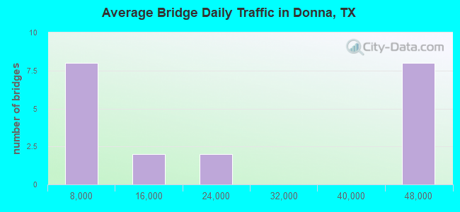
- 421,145Total average daily traffic
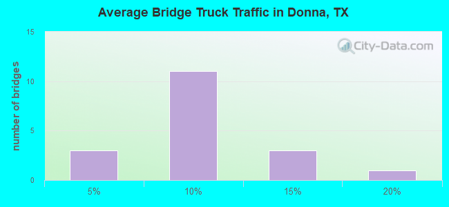
- 29,512Total average daily truck traffic
- National Bridge Inventory (NBI) Registered Bridges for Donna
- No street view available for this location
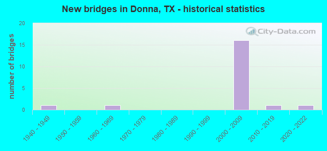
- New bridges - historical statistics
- 11940-1949
- 11960-1969
- 162000-2009
- 12010-2019
- 12020-2022
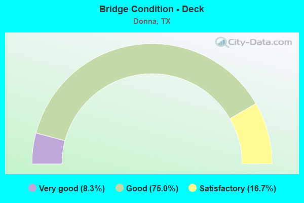
- Bridge Condition - Deck
- 8.3%Very good
- 75.0%Good
- 16.7%Satisfactory
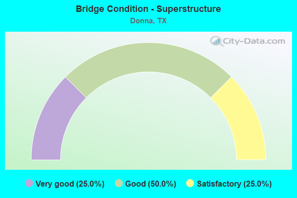
- Bridge Condition - Superstructure
- 25.0%Very good
- 50.0%Good
- 25.0%Satisfactory
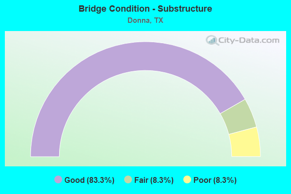
- Bridge Condition - Substructure
- 83.3%Good
- 8.3%Fair
- 8.3%Poor
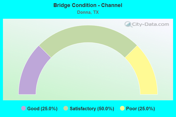
- Bridge Condition - Channel
- 25.0%Good
- 50.0%Satisfactory
- 25.0%Poor
Find on map >> Show street view
Structure Number: 211090003918287, Location: 2.8 MI W OF FM 493 (Lat: 26.186392, Lng: -98.085572), Route carried "on" structure: US 83, Year Built: 2002, Status: Open, Structure Length: 6.95m (22.80ft), Average Daily Traffic: 40,640 (year 2011), Truck Traffic: 7%, Average Future Daily Traffic: 56,890 (year 2031), Design Load: HS 20, Features Intersected: FM 1423/VAL VERDE
Minimum Vertical Clearance: 30+ m (98+ ft), Kilometerpoint: 54.153, Lanes on structure: 4, Lanes under structure: 5, Owner: State Highway Agency, Approaching Roadway Width: 20.4m (66.9ft), Material/Design: Prestressed concrete, Design/Construction: Stringer/Multi-beam, Number Of Spans In Main Unit: 1, Number Of Approach Spans: 2, Length of Maximum Span: 33.5m (109.9ft), Curb-To-Curb Width: 20.3m (66.6ft), Out-to-Out Width: 21.0m (68.9ft)
Condition: Deck: Good, Superstructure: Good, Substructure: Good, Operating Rating: 54.4 metric tons, Method Used To Determine Operating Rating: Assigned rating based on Load Factor Design (LFD) reported in metric tons, Inventory Rating: 32.7 metric tons, Method Used To Determine Inventory Rating: Assigned rating based on Load Factor Design (LFD) reported in metric tons, Structural Evaluation: Better than present minimum criteria, Deck Geometry: Equal to present minimum criteria, Underclear: Better than present minimum criteria, Approach Roadway Alignment: Equal to present desirable criteria, Designated Inspection Frequency: Every 24 months, Inspection Date: April 2021, Deck Structure Type: Concrete Precast Panels
Find on map >> Show street view
Structure Number: 211090003918288, Location: 2.8 MI W OF FM 493 (Lat: 26.186144, Lng: -98.086308), Route carried "on" structure: US 83, Year Built: 2002, Status: Open, Structure Length: 6.95m (22.80ft), Average Daily Traffic: 40,640 (year 2011), Truck Traffic: 7%, Average Future Daily Traffic: 56,890 (year 2031), Design Load: HS 20, Features Intersected: FM 1423/VAL VERDE
Minimum Vertical Clearance: 30+ m (98+ ft), Kilometerpoint: 54.153, Lanes on structure: 4, Lanes under structure: 5, Owner: State Highway Agency, Approaching Roadway Width: 20.4m (66.9ft), Material/Design: Prestressed concrete, Design/Construction: Stringer/Multi-beam, Number Of Spans In Main Unit: 1, Number Of Approach Spans: 2, Length of Maximum Span: 33.5m (109.9ft), Curb-To-Curb Width: 20.3m (66.6ft), Out-to-Out Width: 21.0m (68.9ft)
Condition: Deck: Good, Superstructure: Satisfactory, Substructure: Good, Operating Rating: 54.4 metric tons, Method Used To Determine Operating Rating: Assigned rating based on Load Factor Design (LFD) reported in metric tons, Inventory Rating: 32.7 metric tons, Method Used To Determine Inventory Rating: Assigned rating based on Load Factor Design (LFD) reported in metric tons, Structural Evaluation: Equal to present minimum criteria, Deck Geometry: Equal to present minimum criteria, Underclear: Better than present minimum criteria, Approach Roadway Alignment: Equal to present desirable criteria, Designated Inspection Frequency: Every 24 months, Inspection Date: April 2021, Deck Structure Type: Concrete Precast Panels
Find on map >> Show street view
Structure Number: 211090003918338, Location: 1.25 MI E OF FM 1423 (Lat: 26.183633, Lng: -98.065606), Route carried "on" structure: US 83, Year Built: 2006, Status: Open, Structure Length: 6.19m (20.31ft), Average Daily Traffic: 41,020 (year 2011), Truck Traffic: 7%, Average Future Daily Traffic: 64,690 (year 2031), Design Load: HS 25 or greater, Features Intersected: HUTTO ROAD
Minimum Vertical Clearance: 30+ m (98+ ft), Kilometerpoint: 56.168, Lanes on structure: 4, Lanes under structure: 6, Owner: State Highway Agency, Approaching Roadway Width: 20.7m (67.9ft), Material/Design: Prestressed concrete, Design/Construction: Stringer/Multi-beam, Number Of Spans In Main Unit: 1, Number Of Approach Spans: 2, Length of Maximum Span: 29.0m (95.1ft), Curb-To-Curb Width: 21.0m (68.9ft), Out-to-Out Width: 21.6m (70.9ft)
Condition: Deck: Good, Superstructure: Very good, Substructure: Good, Operating Rating: 68.0 metric tons, Method Used To Determine Operating Rating: Assigned rating based on Load Factor Design (LFD) reported in metric tons, Inventory Rating: 40.8 metric tons, Method Used To Determine Inventory Rating: Assigned rating based on Load Factor Design (LFD) reported in metric tons, Structural Evaluation: Better than present minimum criteria, Deck Geometry: Better than present minimum criteria, Underclear: Superior to present desirable criteria, Approach Roadway Alignment: Equal to present desirable criteria, Designated Inspection Frequency: Every 24 months, Inspection Date: May 2021, Deck Structure Type: Concrete Precast Panels
Find on map >> Show street view
Structure Number: 211090003918339, Location: 1.25 MI E. OF FM 1423 (Lat: 26.183369, Lng: -98.066208), Route carried "on" structure: US 83, Year Built: 2006, Status: Open, Structure Length: 6.19m (20.31ft), Average Daily Traffic: 41,020 (year 2011), Truck Traffic: 7%, Average Future Daily Traffic: 64,690 (year 2031), Design Load: HS 25 or greater, Features Intersected: HUTTO RD
Minimum Vertical Clearance: 30+ m (98+ ft), Kilometerpoint: 56.168, Lanes on structure: 4, Lanes under structure: 6, Owner: State Highway Agency, Approaching Roadway Width: 20.7m (67.9ft), Material/Design: Prestressed concrete, Design/Construction: Stringer/Multi-beam, Number Of Spans In Main Unit: 1, Number Of Approach Spans: 2, Length of Maximum Span: 29.0m (95.1ft), Curb-To-Curb Width: 21.0m (68.9ft), Out-to-Out Width: 21.6m (70.9ft)
Condition: Deck: Good, Superstructure: Very good, Substructure: Good, Operating Rating: 68.0 metric tons, Method Used To Determine Operating Rating: Assigned rating based on Load Factor Design (LFD) reported in metric tons, Inventory Rating: 40.8 metric tons, Method Used To Determine Inventory Rating: Assigned rating based on Load Factor Design (LFD) reported in metric tons, Structural Evaluation: Better than present minimum criteria, Deck Geometry: Better than present minimum criteria, Underclear: Superior to present desirable criteria, Approach Roadway Alignment: Equal to present desirable criteria, Designated Inspection Frequency: Every 24 months, Inspection Date: May 2021, Deck Structure Type: Concrete Precast Panels
Find on map >> Show street view
Structure Number: 21109000391834, Location: 0.70 MI W OF FM 493 (Lat: 26.181758, Lng: -98.052089), Route carried "on" structure: US 83, Year Built: 2005, Status: Open, Structure Length: 6.19m (20.31ft), Average Daily Traffic: 41,020 (year 2011), Truck Traffic: 7%, Average Future Daily Traffic: 64,690 (year 2031), Design Load: HS 25 or greater, Features Intersected: SPUR 433 (MAIN ST)
Minimum Vertical Clearance: 30+ m (98+ ft), Kilometerpoint: 57.534, Lanes on structure: 4, Lanes under structure: 6, Owner: State Highway Agency, Approaching Roadway Width: 20.7m (67.9ft), Material/Design: Prestressed concrete, Design/Construction: Stringer/Multi-beam, Number Of Spans In Main Unit: 1, Number Of Approach Spans: 2, Length of Maximum Span: 29.0m (95.1ft), Curb-To-Curb Width: 20.7m (67.9ft), Out-to-Out Width: 21.6m (70.9ft)
Condition: Deck: Good, Superstructure: Good, Substructure: Good, Operating Rating: 68.0 metric tons, Method Used To Determine Operating Rating: Assigned rating based on Load Factor Design (LFD) reported in metric tons, Inventory Rating: 40.8 metric tons, Method Used To Determine Inventory Rating: Assigned rating based on Load Factor Design (LFD) reported in metric tons, Structural Evaluation: Better than present minimum criteria, Deck Geometry: Equal to present minimum criteria, Underclear: Equal to present minimum criteria, Approach Roadway Alignment: Equal to present desirable criteria, Designated Inspection Frequency: Every 24 months, Inspection Date: May 2021, Deck Structure Type: Concrete Precast Panels
Find on map >> Show street view
Structure Number: 211090003918341, Location: 0.70 MI W OF FM 493 (Lat: 26.181500, Lng: -98.052756), Route carried "on" structure: US 83, Year Built: 2005, Status: Open, Structure Length: 6.19m (20.31ft), Average Daily Traffic: 41,020 (year 2011), Truck Traffic: 7%, Average Future Daily Traffic: 64,690 (year 2031), Design Load: HS 25 or greater, Features Intersected: SPUR 433 (MAIN ST)
Minimum Vertical Clearance: 30+ m (98+ ft), Kilometerpoint: 57.534, Lanes on structure: 4, Lanes under structure: 6, Owner: State Highway Agency, Approaching Roadway Width: 20.7m (67.9ft), Material/Design: Prestressed concrete, Design/Construction: Stringer/Multi-beam, Number Of Spans In Main Unit: 1, Number Of Approach Spans: 2, Length of Maximum Span: 29.0m (95.1ft), Curb-To-Curb Width: 20.7m (67.9ft), Out-to-Out Width: 21.6m (70.9ft)
Condition: Deck: Good, Superstructure: Very good, Substructure: Good, Operating Rating: 68.0 metric tons, Method Used To Determine Operating Rating: Assigned rating based on Load Factor Design (LFD) reported in metric tons, Inventory Rating: 40.8 metric tons, Method Used To Determine Inventory Rating: Assigned rating based on Load Factor Design (LFD) reported in metric tons, Structural Evaluation: Better than present minimum criteria, Deck Geometry: Equal to present minimum criteria, Underclear: Equal to present minimum criteria, Approach Roadway Alignment: Equal to present desirable criteria, Designated Inspection Frequency: Every 24 months, Inspection Date: May 2021, Deck Structure Type: Concrete Precast Panels
Find on map >> Show street view
Structure Number: 211090003918342, Location: 0.70 MI E OF SPUR 433 (Lat: 26.180197, Lng: -98.040731), Route carried "on" structure: US 83, Year Built: 2005, Status: Open, Structure Length: 6.71m (22.01ft), Average Daily Traffic: 41,020 (year 2011), Truck Traffic: 7%, Average Future Daily Traffic: 64,690 (year 2031), Design Load: HS 25 or greater, Features Intersected: FM 493 (D SALINAS)
Minimum Vertical Clearance: 30+ m (98+ ft), Kilometerpoint: 58.675, Lanes on structure: 4, Lanes under structure: 8, Owner: State Highway Agency, Approaching Roadway Width: 20.7m (67.9ft), Material/Design: Prestressed concrete, Design/Construction: Stringer/Multi-beam, Number Of Spans In Main Unit: 1, Number Of Approach Spans: 2, Length of Maximum Span: 34.1m (111.9ft), Curb-To-Curb Width: 20.7m (67.9ft), Out-to-Out Width: 21.6m (70.9ft)
Condition: Deck: Good, Superstructure: Good, Substructure: Good, Operating Rating: 68.0 metric tons, Method Used To Determine Operating Rating: Assigned rating based on Load Factor Design (LFD) reported in metric tons, Inventory Rating: 40.8 metric tons, Method Used To Determine Inventory Rating: Assigned rating based on Load Factor Design (LFD) reported in metric tons, Structural Evaluation: Better than present minimum criteria, Deck Geometry: Equal to present minimum criteria, Underclear: Equal to present minimum criteria, Approach Roadway Alignment: Equal to present desirable criteria, Designated Inspection Frequency: Every 24 months, Inspection Date: May 2021, Deck Structure Type: Concrete Precast Panels
Find on map >> Show street view
Structure Number: 211090003918343, Location: 0.70 MI E OF SPUR 433 (Lat: 26.179947, Lng: -98.041378), Route carried "on" structure: US 83, Year Built: 2005, Status: Open, Structure Length: 6.71m (22.01ft), Average Daily Traffic: 41,020 (year 2011), Truck Traffic: 7%, Average Future Daily Traffic: 64,690 (year 2031), Design Load: HS 25 or greater, Features Intersected: FM 493 (D SALINAS)
Minimum Vertical Clearance: 30+ m (98+ ft), Kilometerpoint: 58.675, Lanes on structure: 4, Lanes under structure: 8, Owner: State Highway Agency, Approaching Roadway Width: 20.7m (67.9ft), Material/Design: Prestressed concrete, Design/Construction: Stringer/Multi-beam, Number Of Spans In Main Unit: 1, Number Of Approach Spans: 2, Length of Maximum Span: 34.1m (111.9ft), Curb-To-Curb Width: 20.7m (67.9ft), Out-to-Out Width: 21.6m (70.9ft)
Condition: Deck: Good, Superstructure: Good, Substructure: Good, Operating Rating: 68.0 metric tons, Method Used To Determine Operating Rating: Assigned rating based on Load Factor Design (LFD) reported in metric tons, Inventory Rating: 40.8 metric tons, Method Used To Determine Inventory Rating: Assigned rating based on Load Factor Design (LFD) reported in metric tons, Structural Evaluation: Better than present minimum criteria, Deck Geometry: Equal to present minimum criteria, Underclear: Equal to present minimum criteria, Approach Roadway Alignment: Equal to present desirable criteria, Designated Inspection Frequency: Every 24 months, Inspection Date: May 2021, Deck Structure Type: Concrete Precast Panels
Find on map >> Show street view
Structure Number: 21109002200101, Location: 0.95 MI W OF FM 493 (Lat: 26.078667, Lng: -98.075511), Route carried "on" structure: US 281, Year Built: 1949, Year Reconstructed: 1959, Status: Open, Structure Length: 1.83m (6.00ft), Average Daily Traffic: 6,554 (year 2019), Truck Traffic: 16%, Average Future Daily Traffic: 7,560 (year 2033), Design Load: H 20, Features Intersected: DONNA MAIN CANAL
Minimum Vertical Clearance: 30+ m (98+ ft), Kilometerpoint: 90.284, Lanes on structure: 2, Owner: State Highway Agency, Approaching Roadway Width: 10.4m (34.1ft), Material/Design: Concrete continuous, Design/Construction: Slab, Number Of Spans In Main Unit: 3, Length of Maximum Span: 7.0m (23.0ft), Curb-To-Curb Width: 13.4m (44.0ft), Out-to-Out Width: 14.0m (45.9ft)
Condition: Deck: Satisfactory, Superstructure: Satisfactory, Substructure: Fair, Channel: Satisfactory, Operating Rating: 45.4 metric tons, Method Used To Determine Operating Rating: Load Factor (LF), Inventory Rating: 27.2 metric tons, Method Used To Determine Inventory Rating: Load Factor (LF), Structural Evaluation: Somewhat better than minimum adequacy, Deck Geometry: Equal to present minimum criteria, Waterway Adequacy: Equal to present minimum criteria, Approach Roadway Alignment: Equal to present desirable criteria, Designated Inspection Frequency: Every 24 months, Underwater Inspection Frequency: Every 60 months, Inspection Date: May 2021, Underwater Inspection Date: September 2019, Deck Structure Type: Concrete Cast-file-Place, Wearing Surface/Protective System: Wearing Surface: Bituminous
Find on map >> Show street view
Structure Number: 211090086301146, Location: 1.10 MI N OF US 281 (Lat: 26.092322, Lng: -98.057125), Route carried "on" structure: State highway 493, Year Built: 2021, Status: Open, Structure Length: 5.03m (16.50ft), Average Daily Traffic: 3,711 (year 2018), Truck Traffic: 5%, Average Future Daily Traffic: 1 (year 1900), Design Load: HL 93, Features Intersected: MAIN FLDWY PILOT CHANNEL
Minimum Vertical Clearance: 30+ m (98+ ft), Kilometerpoint: 45.670, Lanes on structure: 2, Owner: State Highway Agency, Approaching Roadway Width: 13.4m (44.0ft), Skew: 1 degrees, Material/Design: Prestressed concrete, Design/Construction: Box Beam or Girders - Multiple, Number Of Spans In Main Unit: 3, Length of Maximum Span: 18.0m (59.1ft), Curb-To-Curb Width: 13.4m (44.0ft), Out-to-Out Width: 14.0m (45.9ft)
Condition: Deck: Very good, Superstructure: Good, Substructure: Good, Channel: Satisfactory, Operating Rating: 54.4 metric tons, Method Used To Determine Operating Rating: Assigned ratings based on Load and Resistance Factor Design (LRFD) reported in metric tons, Inventory Rating: 32.7 metric tons, Method Used To Determine Inventory Rating: Assigned ratings based on Load and Resistance Factor Design (LRFD) reported in metric tons, Structural Evaluation: Better than present minimum criteria, Deck Geometry: Better than present minimum criteria, Waterway Adequacy: Equal to present minimum criteria, Approach Roadway Alignment: Somewhat better than minimum adequacy, Designated Inspection Frequency: Every 24 months, Inspection Date: May 2021, Deck Structure Type: Concrete Cast-file-Place
Find on map >> Show street view
Structure Number: 211090AA0670002, Location: 4.4 MI S OF BUS 83 (Lat: 26.112450, Lng: -98.086500), Route carried "on" structure: County highway , Year Built: 1960, Status: Posted for load, Structure Length: 1.92m (6.30ft), Average Daily Traffic: 100 (year 2014), Truck Traffic: 1%, Average Future Daily Traffic: 100 (year 2032), Features Intersected: DONNA MAIN CANAL, Facility Carried by Structure: VALLEY VIEW ROAD
Minimum Vertical Clearance: 30+ m (98+ ft), Kilometerpoint: 3.541, Lanes on structure: 2, Owner: County Highway Agency, Approaching Roadway Width: 4.9m (16.1ft), Skew: 3 degrees, Material/Design: Concrete, Design/Construction: Slab, Number Of Spans In Main Unit: 3, Length of Maximum Span: 6.1m (20.0ft), Curb-To-Curb Width: 6.1m (20.0ft), Out-to-Out Width: 6.7m (22.0ft)
Condition: Deck: Satisfactory, Superstructure: Satisfactory, Substructure: Poor, Channel: Poor, Operating Rating: 32.7 metric tons, Method Used To Determine Operating Rating: Field evaluation and documented engineering judgment, Inventory Rating: 24.5 metric tons, Method Used To Determine Inventory Rating: Field evaluation and documented engineering judgment, Structural Evaluation: Meets minimum limits, Deck Geometry: Somewhat better than minimum adequacy, Waterway Adequacy: Better than present minimum criteria, Approach Roadway Alignment: Equal to present minimum criteria, Bridge Posting: Required (Relationship of Operating Rating to Maximum Legal Load: 20.0 - 29.9% below), Designated Inspection Frequency: Every 24 months, Underwater Inspection Frequency: Every 24 months, Inspection Date: April 2020, Underwater Inspection Date: January 2021, Deck Structure Type: Concrete Cast-file-Place
Find on map >> Show street view
Structure Number: 211090C00170001, Location: Donna International Bridg (Lat: 26.065797, Lng: -98.075278), Route carried "on" structure: Other road 493, Year Built: 2011, Status: Open, Structure Length: 30.48m (100.00ft), Average Daily Traffic: 2,340 (year 2011), Truck Traffic: 12%, Average Future Daily Traffic: 3,250 (year 2030), Design Load: HS 20, Features Intersected: Rio Grande River
Minimum Vertical Clearance: 30+ m (98+ ft), Kilometerpoint: 0.002, Lanes on structure: 2, Toll: Toll bridge, Owner: Town or Township Highway Agency, Approaching Roadway Width: 30.5m (100.1ft), Material/Design: Prestressed concrete, Design/Construction: Stringer/Multi-beam, Number Of Spans In Main Unit: 10, Length of Maximum Span: 33.5m (109.9ft), Curb or Sidewalk Widths: Left: 2.4m (7.9ft), Right: 0.0m, Curb-To-Curb Width: 30.5m (100.1ft), Out-to-Out Width: 33.1m (108.6ft)
Condition: Deck: Good, Superstructure: Good, Substructure: Good, Channel: Good, Operating Rating: 54.4 metric tons, Method Used To Determine Operating Rating: Assigned rating based on Load Factor Design (LFD) reported in metric tons, Inventory Rating: 32.7 metric tons, Method Used To Determine Inventory Rating: Assigned rating based on Load Factor Design (LFD) reported in metric tons, Structural Evaluation: Better than present minimum criteria, Deck Geometry: Superior to present desirable criteria, Waterway Adequacy: Equal to present minimum criteria, Approach Roadway Alignment: Equal to present desirable criteria, Designated Inspection Frequency: Every 24 months, Inspection Date: November 2019, Deck Structure Type: Concrete Cast-file-Place
Find on map >> Show street view
Structure Number: 211090003918287, Location: 2.8 MI W OF FM 493 (Lat: 26.186392, Lng: -98.085572), Route carried "under" structure: State highway 1423, Year Built: 2002, Structure Length: 0. m, Average Daily Traffic: 7,080 (year 2009), Truck Traffic: 7%, Features Intersected: FM 1423/VAL VERDE, Facility Carried by Structure: US 83 WB
Minimum Vertical Clearance: 5.03m (16.50ft), Kilometerpoint: 12.394, Lanes on structure: 4, Lanes under structure: 5, Material/Design: Prestressed concrete, Design/Construction: Stringer/Multi-beam, Length of Maximum Span: 33.5m (109.9ft)
Find on map >> Show street view
Structure Number: 211090003918288, Location: 2.8 MI W OF FM 493 (Lat: 26.186144, Lng: -98.086308), Route carried "under" structure: State highway 1423, Year Built: 2002, Structure Length: 0. m, Average Daily Traffic: 7,080 (year 2009), Truck Traffic: 7%, Features Intersected: FM 1423/VAL VERDE, Facility Carried by Structure: US 83 EB
Minimum Vertical Clearance: 5.03m (16.50ft), Kilometerpoint: 12.394, Lanes on structure: 4, Lanes under structure: 5, Material/Design: Prestressed concrete, Design/Construction: Stringer/Multi-beam, Length of Maximum Span: 33.5m (109.9ft)
Find on map >> Show street view
Structure Number: 211090003918338, Location: 1.25 MI E OF FM 1423 (Lat: 26.183633, Lng: -98.065606), Route carried "under" structure: County highway , Year Built: 2006, Structure Length: 0. m, Average Daily Traffic: 1,500 (year 2009), Features Intersected: HUTTO ROAD, Facility Carried by Structure: US 83 WB
Minimum Vertical Clearance: 5.13m (16.83ft), Kilometerpoint: 0.000, Lanes on structure: 4, Lanes under structure: 6, Material/Design: Prestressed concrete, Design/Construction: Stringer/Multi-beam, Length of Maximum Span: 29.0m (95.1ft)
Find on map >> Show street view
Structure Number: 211090003918339, Location: 1.25 MI E. OF FM 1423 (Lat: 26.183369, Lng: -98.066208), Route carried "under" structure: County highway , Year Built: 2006, Structure Length: 0. m, Average Daily Traffic: 1,500 (year 2009), Features Intersected: HUTTO RD, Facility Carried by Structure: US 83 EB
Minimum Vertical Clearance: 5.13m (16.83ft), Kilometerpoint: 0.000, Lanes on structure: 4, Lanes under structure: 6, Material/Design: Prestressed concrete, Design/Construction: Stringer/Multi-beam, Length of Maximum Span: 29.0m (95.1ft)
Find on map >> Show street view
Structure Number: 21109000391834, Location: 0.70 MI W OF FM 493 (Lat: 26.181758, Lng: -98.052089), Route carried "under" structure: Spur State highway 433, Year Built: 2005, Structure Length: 0. m, Average Daily Traffic: 12,100 (year 2013), Truck Traffic: 12%, Features Intersected: SPUR 433 (MAIN ST), Facility Carried by Structure: US 83 WB
Minimum Vertical Clearance: 5.05m (16.57ft), Kilometerpoint: 16.074, Lanes on structure: 4, Lanes under structure: 6, Material/Design: Prestressed concrete, Design/Construction: Stringer/Multi-beam, Length of Maximum Span: 29.0m (95.1ft)
Find on map >> Show street view
Structure Number: 211090003918341, Location: 0.70 MI W OF FM 493 (Lat: 26.181500, Lng: -98.052756), Route carried "under" structure: Spur State highway 433, Year Built: 2005, Structure Length: 0. m, Average Daily Traffic: 12,100 (year 2013), Truck Traffic: 12%, Features Intersected: SPUR 433 (MAIN ST), Facility Carried by Structure: US 83 EB
Minimum Vertical Clearance: 5.05m (16.57ft), Kilometerpoint: 16.093, Lanes on structure: 4, Lanes under structure: 6, Material/Design: Prestressed concrete, Design/Construction: Stringer/Multi-beam, Length of Maximum Span: 29.0m (95.1ft)
Find on map >> Show street view
Structure Number: 211090003918342, Location: 0.70 MI E OF SPUR 433 (Lat: 26.180197, Lng: -98.040731), Route carried "under" structure: State highway 493, Year Built: 2005, Structure Length: 0. m, Average Daily Traffic: 19,840 (year 2013), Truck Traffic: 3%, Features Intersected: FM 493 (D SALINAS), Facility Carried by Structure: US 83 WB
Minimum Vertical Clearance: 5.13m (16.83ft), Kilometerpoint: 35.863, Lanes on structure: 4, Lanes under structure: 8, Material/Design: Prestressed concrete, Design/Construction: Stringer/Multi-beam, Length of Maximum Span: 34.1m (111.9ft)
Find on map >> Show street view
Structure Number: 211090003918343, Location: 0.70 MI E OF SPUR 433 (Lat: 26.179947, Lng: -98.041378), Route carried "under" structure: State highway 493, Year Built: 2005, Structure Length: 0. m, Average Daily Traffic: 19,840 (year 2013), Truck Traffic: 3%, Features Intersected: FM 493 (D SALINAS), Facility Carried by Structure: US 83 EB
Minimum Vertical Clearance: 5.21m (17.09ft), Kilometerpoint: 35.882, Lanes on structure: 4, Lanes under structure: 8, Material/Design: Prestressed concrete, Design/Construction: Stringer/Multi-beam, Length of Maximum Span: 34.1m (111.9ft)