Bridge Statistics for Dublin, Georgia (GA)
Condition, Traffic, Stress, Structural Evaluation, Project Costs
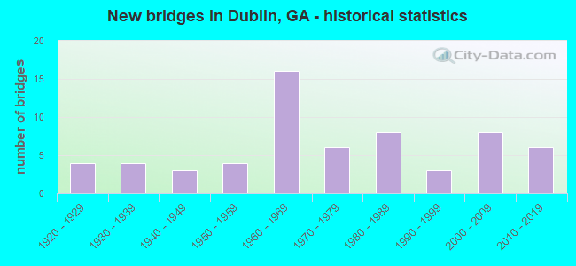
- New bridges - historical statistics
- 41920-1929
- 41930-1939
- 31940-1949
- 41950-1959
- 161960-1969
- 61970-1979
- 81980-1989
- 31990-1999
- 82000-2009
- 62010-2019
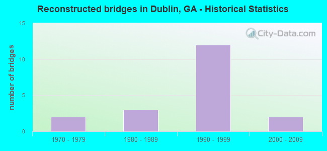
- Reconstructed bridges - Historical Statistics
- 21970-1979
- 31980-1989
- 121990-1999
- 22000-2009
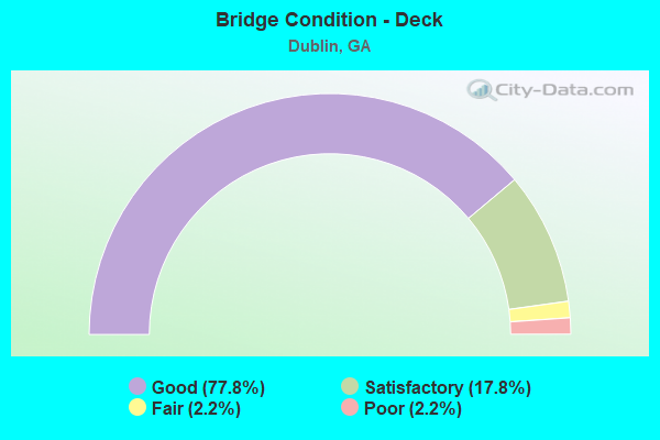
- Bridge Condition - Deck
- 77.8%Good
- 17.8%Satisfactory
- 2.2%Fair
- 2.2%Poor
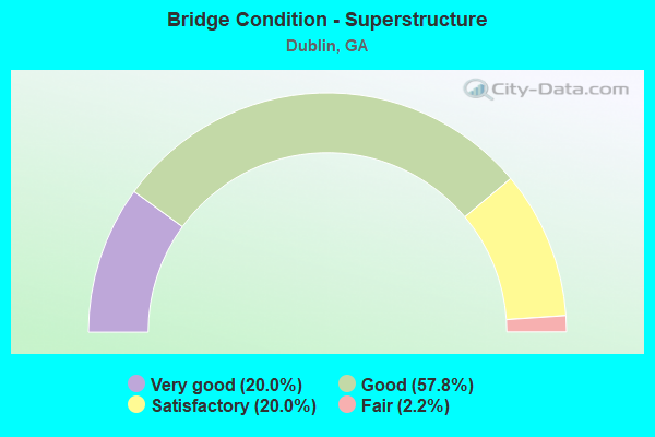
- Bridge Condition - Superstructure
- 20.0%Very good
- 57.8%Good
- 20.0%Satisfactory
- 2.2%Fair
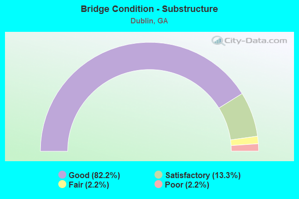
- Bridge Condition - Substructure
- 82.2%Good
- 13.3%Satisfactory
- 2.2%Fair
- 2.2%Poor
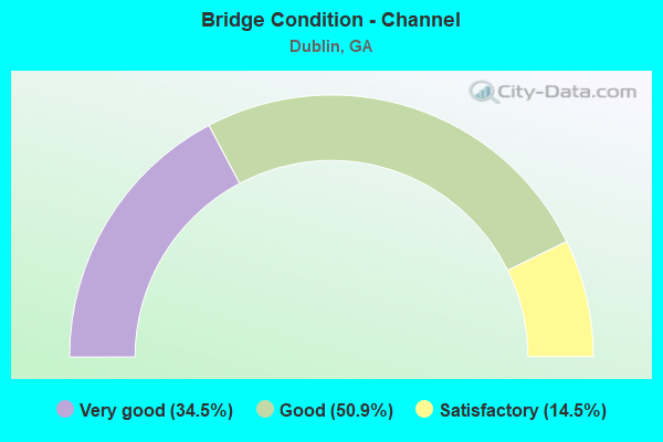
- Bridge Condition - Channel
- 34.5%Very good
- 50.9%Good
- 14.5%Satisfactory
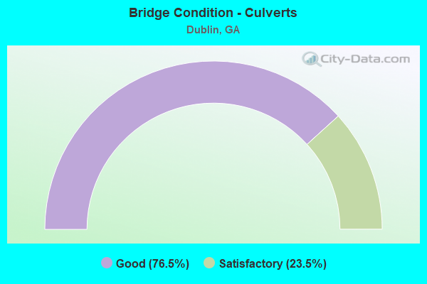
- Bridge Condition - Culverts
- 76.5%Good
- 23.5%Satisfactory
Find on map >> Show street view
Structure Number: 175003, Location: 4 MI N OF FITZGERALD (Lat: 31.774450, Lng: -83.265019), Route carried "on" structure: County highway 68, Year Built: 1955, Status: Open, Structure Length: 2.44m (8.01ft), Average Daily Traffic: 640 (year 2011), Truck Traffic: 1%, Average Future Daily Traffic: 960 (year 2031), Design Load: H 10, Features Intersected: OTTER CREEK, Facility Carried by Structure: BETHLEHAM CH RD
Minimum Vertical Clearance: 30+ m (98+ ft), Kilometerpoint: 0.000, Lanes on structure: 2, Base Highway Network: Yes, Owner: County Highway Agency, Approaching Roadway Width: 5.8m (19.0ft), Material/Design: Steel continuous, Design/Construction: Stringer/Multi-beam, Number Of Spans In Main Unit: 4, Length of Maximum Span: 6.1m (20.0ft), Curb or Sidewalk Widths: Left: 0.2m (0.7ft), Right: 0.2m (0.7ft), Curb-To-Curb Width: 6.0m (19.7ft), Out-to-Out Width: 6.4m (21.0ft)
Condition: Deck: Poor, Superstructure: Satisfactory, Substructure: Satisfactory, Channel: Satisfactory, Operating Rating: 40.8 metric tons, Method Used To Determine Operating Rating: Load Factor (LF), Inventory Rating: 24.4 metric tons, Method Used To Determine Inventory Rating: Load Factor (LF), Structural Evaluation: Equal to present minimum criteria, Deck Geometry: High priority of replacement, Waterway Adequacy: Somewhat better than minimum adequacy, Approach Roadway Alignment: Equal to present minimum criteria, Length Of Structure Improvement: 8.87m (29.10ft), Designated Inspection Frequency: Every 24 months, Underwater Inspection Frequency: Every 60 months, Inspection Date: May 2020, Underwater Inspection Date: April 2020, Bridge Improvement Cost: $313,000, Roadway Improvement Cost: $31,000, Total Project Cost: $469,000, Deck Structure Type: Concrete Cast-file-Place
Find on map >> Show street view
Structure Number: 175009, Location: 2.5 MI S OF FITZGERALD (Lat: 31.679519, Lng: -83.250858), Route carried "on" structure: County highway 124, Year Built: 1985, Status: Open, Structure Length: 0.88m (2.89ft), Average Daily Traffic: 420 (year 2011), Truck Traffic: 13%, Average Future Daily Traffic: 630 (year 2031), Design Load: HS 20+Mod, Features Intersected: TURKEY BRANCH, Facility Carried by Structure: ED WARD ROAD
Minimum Vertical Clearance: 30+ m (98+ ft), Kilometerpoint: 1.609, Lanes on structure: 2, Base Highway Network: Yes, Owner: County Highway Agency, Approaching Roadway Width: 6.1m (20.0ft), Material/Design: Concrete, Design/Construction: Culvert, Number Of Spans In Main Unit: 3, Length of Maximum Span: 2.7m (8.9ft)
Condition: Channel: Good, Culverts: Good, Operating Rating: 55.3 metric tons, Method Used To Determine Operating Rating: Field evaluation and documented engineering judgment, Inventory Rating: 32.6 metric tons, Method Used To Determine Inventory Rating: Field evaluation and documented engineering judgment, Structural Evaluation: Better than present minimum criteria, Waterway Adequacy: Better than present minimum criteria, Approach Roadway Alignment: Better than present minimum criteria, Designated Inspection Frequency: Every 24 months, Underwater Inspection Frequency: Every 60 months, Inspection Date: May 2020, Underwater Inspection Date: April 2020, Bridge Improvement Cost: $113,000, Roadway Improvement Cost: $11,000, Total Project Cost: $170,000
Find on map >> Show street view
Structure Number: 1750001, Location: 15 MI SE OF RENTZ (Lat: 32.298539, Lng: -82.744908), Route carried "on" structure: State highway 19, Year Built: 1950, Status: Open, Structure Length: 0.79m (2.59ft), Average Daily Traffic: 1,520 (year 2012), Truck Traffic: 1%, Average Future Daily Traffic: 2,280 (year 2032), Design Load: H 15, Features Intersected: BUCK CREEK
Minimum Vertical Clearance: 30+ m (98+ ft), Kilometerpoint: 0.000, Lanes on structure: 2, Base Highway Network: Yes, Owner: State Highway Agency, Approaching Roadway Width: 8.5m (27.9ft), Material/Design: Concrete, Design/Construction: Culvert, Number Of Spans In Main Unit: 3, Length of Maximum Span: 2.4m (7.9ft)
Condition: Channel: Very good, Culverts: Good, Operating Rating: 41.7 metric tons, Method Used To Determine Operating Rating: Field evaluation and documented engineering judgment, Inventory Rating: 24.4 metric tons, Method Used To Determine Inventory Rating: Field evaluation and documented engineering judgment, Structural Evaluation: Equal to present minimum criteria, Waterway Adequacy: Equal to present desirable criteria, Approach Roadway Alignment: Equal to present desirable criteria, Designated Inspection Frequency: Every 24 months, Inspection Date: March 2021
Find on map >> Show street view
Structure Number: 1750008, Location: 3.8 MI S OF DUBLIN (Lat: 32.485278, Lng: -82.895678), Route carried "on" structure: State highway 19, Year Built: 1964, Status: Open, Structure Length: 6.28m (20.60ft), Average Daily Traffic: 2,310 (year 2012), Truck Traffic: 18%, Average Future Daily Traffic: 3,465 (year 2032), Design Load: HS 20+Mod, Features Intersected: I-16 (SR 404)
Minimum Vertical Clearance: 30+ m (98+ ft), Kilometerpoint: 27.359, Lanes on structure: 2, Lanes under structure: 4, Base Highway Network: Yes, Owner: State Highway Agency, Approaching Roadway Width: 8.5m (27.9ft), Material/Design: Steel, Design/Construction: Stringer/Multi-beam, Number Of Spans In Main Unit: 4, Length of Maximum Span: 21.3m (69.9ft), Curb or Sidewalk Widths: Left: 0.6m (2.0ft), Right: 0.6m (2.0ft), Curb-To-Curb Width: 8.5m (27.9ft), Out-to-Out Width: 10.5m (34.4ft)
Condition: Deck: Good, Superstructure: Good, Substructure: Good, Operating Rating: 38.1 metric tons, Method Used To Determine Operating Rating: Load Factor (LF), Inventory Rating: 22.6 metric tons, Method Used To Determine Inventory Rating: Load Factor (LF), Structural Evaluation: Equal to present minimum criteria, Deck Geometry: Meets minimum limits, Underclear: Meets minimum limits, Approach Roadway Alignment: Equal to present desirable criteria, Designated Inspection Frequency: Every 24 months, Inspection Date: May 2021, Deck Structure Type: Concrete Cast-file-Place, Wearing Surface/Protective System: Wearing Surface: Epoxy Overlay
Find on map >> Show street view
Structure Number: 1750009, Location: IN CITY LIMITS OF DUBLIN (Lat: 32.540558, Lng: -82.946358), Route carried "on" structure: US 80, Year Built: 1979, Year Reconstructed: 1987, Status: Open, Structure Length: 1.31m (4.30ft), Average Daily Traffic: 11,040 (year 2012), Truck Traffic: 5%, Average Future Daily Traffic: 16,560 (year 2032), Design Load: HS 20+Mod, Features Intersected: BUDS CREEK
Minimum Vertical Clearance: 30+ m (98+ ft), Kilometerpoint: 37.015, Lanes on structure: 5, Base Highway Network: Yes, Owner: State Highway Agency, Approaching Roadway Width: 20.1m (65.9ft), Material/Design: Concrete, Design/Construction: Culvert, Number Of Spans In Main Unit: 3, Length of Maximum Span: 3.0m (9.8ft)
Condition: Channel: Good, Culverts: Good, Operating Rating: 59.8 metric tons, Method Used To Determine Operating Rating: Load Factor (LF), Inventory Rating: 36.2 metric tons, Method Used To Determine Inventory Rating: Load Factor (LF), Structural Evaluation: Better than present minimum criteria, Waterway Adequacy: Equal to present desirable criteria, Approach Roadway Alignment: Equal to present desirable criteria, Designated Inspection Frequency: Every 24 months, Inspection Date: April 2021
Find on map >> Show street view
Structure Number: 175001, Location: 3.4 MI W OF DUBLIN (Lat: 32.544258, Lng: -82.961728), Route carried "on" structure: US 80, Year Built: 1931, Year Reconstructed: 2001, Status: Open, Structure Length: 0.98m (3.22ft), Average Daily Traffic: 10,900 (year 2012), Truck Traffic: 1%, Average Future Daily Traffic: 16,350 (year 2032), Design Load: H 15, Features Intersected: SANDY FORD CREEK
Minimum Vertical Clearance: 30+ m (98+ ft), Kilometerpoint: 38.624, Lanes on structure: 5, Base Highway Network: Yes, Owner: State Highway Agency, Approaching Roadway Width: 22.3m (73.2ft), Skew: 9 degrees, Material/Design: Concrete, Design/Construction: Culvert, Number Of Spans In Main Unit: 3, Length of Maximum Span: 3.0m (9.8ft)
Condition: Channel: Very good, Culverts: Good, Operating Rating: 41.7 metric tons, Method Used To Determine Operating Rating: Field evaluation and documented engineering judgment, Inventory Rating: 24.4 metric tons, Method Used To Determine Inventory Rating: Field evaluation and documented engineering judgment, Structural Evaluation: Equal to present minimum criteria, Waterway Adequacy: Equal to present desirable criteria, Approach Roadway Alignment: Equal to present desirable criteria, Length Of Structure Improvement: 7.41m (24.31ft), Designated Inspection Frequency: Every 24 months, Inspection Date: April 2021, Roadway Improvement Cost: $81,000, Total Project Cost: $92,000
Find on map >> Show street view
Structure Number: 1750017, Location: NE DUBLIN CITY LIMITS (Lat: 32.544189, Lng: -82.892650), Route carried "on" structure: US 80, Year Built: 1952, Status: Open, Structure Length: 23.47m (77.00ft), Average Daily Traffic: 24,060 (year 2012), Truck Traffic: 1%, Average Future Daily Traffic: 36,090 (year 2032), Design Load: HS 20+Mod, Features Intersected: OCONEE RIVER
Minimum Vertical Clearance: 30+ m (98+ ft), Kilometerpoint: 30.578, Lanes on structure: 4, Base Highway Network: Yes, Owner: State Highway Agency, Approaching Roadway Width: 17.7m (58.1ft), Skew: 20 degrees, Material/Design: Steel continuous, Design/Construction: Stringer/Multi-beam, Number Of Spans In Main Unit: 9, Length of Maximum Span: 45.7m (149.9ft), Curb or Sidewalk Widths: Left: 1.5m (4.9ft), Right: 1.5m (4.9ft), Curb-To-Curb Width: 17.6m (57.7ft), Out-to-Out Width: 21.2m (69.6ft)
Condition: Deck: Satisfactory, Superstructure: Good, Substructure: Good, Channel: Good, Operating Rating: 31.7 metric tons, Method Used To Determine Operating Rating: Load Factor (LF), Inventory Rating: 19.0 metric tons, Method Used To Determine Inventory Rating: Load Factor (LF), Structural Evaluation: Meets minimum limits, Deck Geometry: Somewhat better than minimum adequacy, Waterway Adequacy: Equal to present desirable criteria, Approach Roadway Alignment: Equal to present desirable criteria, Designated Inspection Frequency: Every 24 months, Underwater Inspection Frequency: Every 60 months, Inspection Date: April 2021, Underwater Inspection Date: January 2020, Deck Structure Type: Concrete Cast-file-Place
Find on map >> Show street view
Structure Number: 1750021, Location: 4.1 MI SE OF BREWTON (Lat: 32.555078, Lng: -82.743108), Route carried "on" structure: US 80, Year Built: 1949, Year Reconstructed: 1994, Status: Open, Structure Length: 0.64m (2.10ft), Average Daily Traffic: 1,810 (year 2012), Truck Traffic: 1%, Average Future Daily Traffic: 2,715 (year 2032), Design Load: H 15, Features Intersected: FLANDERS BRANCH
Minimum Vertical Clearance: 30+ m (98+ ft), Kilometerpoint: 45.062, Lanes on structure: 2, Base Highway Network: Yes, Owner: State Highway Agency, Approaching Roadway Width: 8.5m (27.9ft), Material/Design: Concrete, Design/Construction: Culvert, Number Of Spans In Main Unit: 2, Length of Maximum Span: 3.0m (9.8ft)
Condition: Channel: Very good, Culverts: Satisfactory, Operating Rating: 41.7 metric tons, Method Used To Determine Operating Rating: Field evaluation and documented engineering judgment, Inventory Rating: 24.4 metric tons, Method Used To Determine Inventory Rating: Field evaluation and documented engineering judgment, Structural Evaluation: Equal to present minimum criteria, Waterway Adequacy: Equal to present desirable criteria, Approach Roadway Alignment: Equal to present desirable criteria, Length Of Structure Improvement: 40.87m (134.09ft), Designated Inspection Frequency: Every 24 months, Inspection Date: April 2021, Roadway Improvement Cost: $256,000, Total Project Cost: $284,000
Find on map >> Show street view
Structure Number: 1750025, Location: IN N CITY LIMITS DUBLIN (Lat: 32.555950, Lng: -82.913969), Route carried "on" structure: US 441, Year Built: 1938, Year Reconstructed: 1998, Status: Open, Structure Length: 4.15m (13.62ft), Average Daily Traffic: 9,340 (year 2012), Truck Traffic: 1%, Average Future Daily Traffic: 14,010 (year 2032), Design Load: H 15, Features Intersected: HUNGER & HARDSHIP CREEK
Minimum Vertical Clearance: 30+ m (98+ ft), Kilometerpoint: 25.750, Lanes on structure: 5, Base Highway Network: Yes, Owner: State Highway Agency, Approaching Roadway Width: 19.5m (64.0ft), Material/Design: Concrete, Design/Construction: Tee Beam, Number Of Spans In Main Unit: 4, Length of Maximum Span: 10.4m (34.1ft), Curb or Sidewalk Widths: Left: 1.8m (5.9ft), Right: 1.8m (5.9ft), Curb-To-Curb Width: 20.1m (65.9ft), Out-to-Out Width: 24.4m (80.1ft)
Condition: Deck: Good, Superstructure: Good, Substructure: Good, Channel: Good, Operating Rating: 58.0 metric tons, Method Used To Determine Operating Rating: Load Factor (LF), Inventory Rating: 34.4 metric tons, Method Used To Determine Inventory Rating: Load Factor (LF), Structural Evaluation: Better than present minimum criteria, Deck Geometry: Somewhat better than minimum adequacy, Waterway Adequacy: Equal to present desirable criteria, Approach Roadway Alignment: Equal to present desirable criteria, Length Of Structure Improvement: 10.58m (34.71ft), Designated Inspection Frequency: Every 24 months, Underwater Inspection Frequency: Every 60 months, Inspection Date: April 2021, Underwater Inspection Date: January 2020, Bridge Improvement Cost: $170,000, Roadway Improvement Cost: $51,000, Total Project Cost: $288,000, Deck Structure Type: Concrete Cast-file-Place
Find on map >> Show street view
Structure Number: 175003, Location: 6 MI S OF DUBLIN (Lat: 32.455708, Lng: -82.942389), Route carried "on" structure: US 319, Year Built: 1957, Year Reconstructed: 1991, Status: Open, Structure Length: 9.88m (32.41ft), Average Daily Traffic: 7,000 (year 2012), Truck Traffic: 1%, Average Future Daily Traffic: 10,500 (year 2032), Design Load: HS 20, Features Intersected: TURKEY CREEK
Minimum Vertical Clearance: 30+ m (98+ ft), Kilometerpoint: 30.578, Lanes on structure: 4, Base Highway Network: Yes, Owner: State Highway Agency, Approaching Roadway Width: 8.5m (27.9ft), Material/Design: Concrete, Design/Construction: Tee Beam, Number Of Spans In Main Unit: 9, Length of Maximum Span: 11.0m (36.1ft), Curb-To-Curb Width: 25.0m (82.0ft), Out-to-Out Width: 26.0m (85.3ft)
Condition: Deck: Good, Superstructure: Good, Substructure: Good, Channel: Good, Operating Rating: 42.6 metric tons, Method Used To Determine Operating Rating: Load Factor (LF), Inventory Rating: 25.4 metric tons, Method Used To Determine Inventory Rating: Load Factor (LF), Structural Evaluation: Equal to present minimum criteria, Deck Geometry: Superior to present desirable criteria, Waterway Adequacy: Equal to present desirable criteria, Approach Roadway Alignment: Equal to present desirable criteria, Designated Inspection Frequency: Every 24 months, Underwater Inspection Frequency: Every 60 months, Inspection Date: March 2021, Underwater Inspection Date: January 2020, Deck Structure Type: Concrete Cast-file-Place
Find on map >> Show street view
Structure Number: 1750031, Location: 4 MI S OF DUBLIN (Lat: 32.487800, Lng: -82.935219), Route carried "on" structure: US 319, Year Built: 1965, Year Reconstructed: 1997, Status: Open, Structure Length: 8.90m (29.20ft), Average Daily Traffic: 10,900 (year 2012), Truck Traffic: 1%, Average Future Daily Traffic: 16,350 (year 2032), Design Load: HS 20+Mod, Features Intersected: I-16 (SR 404)
Minimum Vertical Clearance: 30+ m (98+ ft), Kilometerpoint: 33.796, Lanes on structure: 6, Lanes under structure: 4, Base Highway Network: Yes, Owner: State Highway Agency, Approaching Roadway Width: 21.9m (71.9ft), Skew: 2 degrees, Material/Design: Steel continuous, Design/Construction: Stringer/Multi-beam, Number Of Spans In Main Unit: 4, Length of Maximum Span: 25.0m (82.0ft), Curb-To-Curb Width: 28.0m (91.9ft), Out-to-Out Width: 28.9m (94.8ft)
Condition: Deck: Satisfactory, Superstructure: Good, Substructure: Good, Operating Rating: 51.7 metric tons, Method Used To Determine Operating Rating: Allowable Stress (AS), Inventory Rating: 31.7 metric tons, Method Used To Determine Inventory Rating: Allowable Stress (AS), Structural Evaluation: Better than present minimum criteria, Deck Geometry: Superior to present desirable criteria, Underclear: Equal to present minimum criteria, Approach Roadway Alignment: Equal to present desirable criteria, Designated Inspection Frequency: Every 24 months, Inspection Date: May 2021, Deck Structure Type: Concrete Cast-file-Place
Find on map >> Show street view
Structure Number: 1750033, Location: IN CITY LIMITS OF DUBLIN (Lat: 32.516639, Lng: -82.922489), Route carried "on" structure: US 319, Year Built: 1936, Year Reconstructed: 1979, Status: Open, Structure Length: 0.70m (2.30ft), Average Daily Traffic: 15,000 (year 2012), Truck Traffic: 1%, Average Future Daily Traffic: 22,500 (year 2032), Design Load: H 15, Features Intersected: LONG BRANCH
Minimum Vertical Clearance: 30+ m (98+ ft), Kilometerpoint: 38.624, Lanes on structure: 5, Base Highway Network: Yes, Owner: State Highway Agency, Approaching Roadway Width: 18.0m (59.1ft), Material/Design: Concrete, Design/Construction: Culvert, Number Of Spans In Main Unit: 3, Length of Maximum Span: 2.1m (6.9ft)
Condition: Channel: Good, Culverts: Good, Operating Rating: 78.0 metric tons, Method Used To Determine Operating Rating: Load Factor (LF), Inventory Rating: 47.1 metric tons, Method Used To Determine Inventory Rating: Load Factor (LF), Structural Evaluation: Better than present minimum criteria, Waterway Adequacy: Equal to present desirable criteria, Approach Roadway Alignment: Equal to present desirable criteria, Designated Inspection Frequency: Every 24 months, Inspection Date: March 2021
Find on map >> Show street view
Structure Number: 1750057, Location: 3.5 MI NE OF DEXTER (Lat: 32.463319, Lng: -83.003289), Route carried "on" structure: State highway 257, Year Built: 1977, Status: Open, Structure Length: 7.32m (24.02ft), Average Daily Traffic: 6,200 (year 2012), Truck Traffic: 9%, Average Future Daily Traffic: 9,300 (year 2032), Design Load: HS 20+Mod, Features Intersected: ROCKY CREEK
Minimum Vertical Clearance: 30+ m (98+ ft), Kilometerpoint: 14.484, Lanes on structure: 2, Base Highway Network: Yes, Owner: State Highway Agency, Approaching Roadway Width: 8.8m (28.9ft), Material/Design: Concrete, Design/Construction: Tee Beam, Number Of Spans In Main Unit: 6, Length of Maximum Span: 12.2m (40.0ft), Curb-To-Curb Width: 13.0m (42.7ft), Out-to-Out Width: 14.0m (45.9ft)
Condition: Deck: Good, Superstructure: Good, Substructure: Satisfactory, Channel: Satisfactory, Operating Rating: 36.2 metric tons, Method Used To Determine Operating Rating: Load Factor (LF), Inventory Rating: 21.7 metric tons, Method Used To Determine Inventory Rating: Load Factor (LF), Structural Evaluation: Somewhat better than minimum adequacy, Deck Geometry: Somewhat better than minimum adequacy, Waterway Adequacy: Equal to present desirable criteria, Approach Roadway Alignment: Equal to present desirable criteria, Designated Inspection Frequency: Every 24 months, Underwater Inspection Frequency: Every 60 months, Inspection Date: March 2021, Underwater Inspection Date: January 2020, Deck Structure Type: Concrete Cast-file-Place
Find on map >> Show street view
Structure Number: 1750058, Location: 5 MI NE OF DEXTER (Lat: 32.483389, Lng: -82.995139), Route carried "on" structure: State highway 257, Year Built: 1977, Status: Open, Structure Length: 4.88m (16.01ft), Average Daily Traffic: 6,200 (year 2012), Truck Traffic: 9%, Average Future Daily Traffic: 9,300 (year 2032), Design Load: HS 20, Features Intersected: TURKEY CREEK OVERFLOW
Minimum Vertical Clearance: 30+ m (98+ ft), Kilometerpoint: 16.093, Lanes on structure: 2, Base Highway Network: Yes, Owner: State Highway Agency, Approaching Roadway Width: 8.8m (28.9ft), Material/Design: Concrete, Design/Construction: Tee Beam, Number Of Spans In Main Unit: 4, Length of Maximum Span: 12.2m (40.0ft), Curb-To-Curb Width: 13.0m (42.7ft), Out-to-Out Width: 14.0m (45.9ft)
Condition: Deck: Good, Superstructure: Good, Substructure: Good, Channel: Very good, Operating Rating: 37.1 metric tons, Method Used To Determine Operating Rating: Load Factor (LF), Inventory Rating: 21.7 metric tons, Method Used To Determine Inventory Rating: Load Factor (LF), Structural Evaluation: Somewhat better than minimum adequacy, Deck Geometry: Somewhat better than minimum adequacy, Waterway Adequacy: Equal to present desirable criteria, Approach Roadway Alignment: Equal to present desirable criteria, Designated Inspection Frequency: Every 24 months, Inspection Date: March 2021, Deck Structure Type: Concrete Cast-file-Place
Find on map >> Show street view
Structure Number: 1750059, Location: 5 MI NE OF DEXTER (Lat: 32.484928, Lng: -82.993897), Route carried "on" structure: State highway 257, Year Built: 1977, Status: Open, Structure Length: 3.66m (12.01ft), Average Daily Traffic: 6,200 (year 2012), Truck Traffic: 9%, Average Future Daily Traffic: 9,300 (year 2032), Design Load: HS 20, Features Intersected: TURKEY CREEK
Minimum Vertical Clearance: 30+ m (98+ ft), Kilometerpoint: 17.703, Lanes on structure: 2, Base Highway Network: Yes, Owner: State Highway Agency, Approaching Roadway Width: 8.8m (28.9ft), Material/Design: Concrete, Design/Construction: Tee Beam, Number Of Spans In Main Unit: 3, Length of Maximum Span: 12.2m (40.0ft), Curb-To-Curb Width: 13.0m (42.7ft), Out-to-Out Width: 14.0m (45.9ft)
Condition: Deck: Good, Superstructure: Good, Substructure: Good, Channel: Satisfactory, Operating Rating: 34.4 metric tons, Method Used To Determine Operating Rating: Load Factor (LF), Inventory Rating: 16.3 metric tons, Method Used To Determine Inventory Rating: Load Factor (LF), Structural Evaluation: Meets minimum limits, Deck Geometry: Somewhat better than minimum adequacy, Waterway Adequacy: Equal to present desirable criteria, Approach Roadway Alignment: Equal to present desirable criteria, Designated Inspection Frequency: Every 24 months, Inspection Date: March 2021, Deck Structure Type: Concrete Cast-file-Place
Find on map >> Show street view
Structure Number: 1750072, Location: 4.5 MI SE OF DUDLEY (Lat: 32.503050, Lng: -83.009200), Route carried "on" structure: Interstate 16, Year Built: 1965, Year Reconstructed: 2001, Status: Open, Structure Length: 8.11m (26.61ft), Average Daily Traffic: 20,790 (year 2012), Truck Traffic: 23%, Average Future Daily Traffic: 31,185 (year 2032), Design Load: HS 20+Mod, Features Intersected: TURKEY CREEK
Minimum Vertical Clearance: 30+ m (98+ ft), Kilometerpoint: 75.639, Lanes on structure: 2, Base Highway Network: Yes, Owner: State Highway Agency, Approaching Roadway Width: 13.4m (44.0ft), Skew: 10 degrees, Material/Design: Concrete, Design/Construction: Tee Beam, Number Of Spans In Main Unit: 7, Length of Maximum Span: 11.6m (38.1ft), Curb-To-Curb Width: 13.0m (42.7ft), Out-to-Out Width: 14.0m (45.9ft)
Condition: Deck: Good, Superstructure: Good, Substructure: Good, Channel: Satisfactory, Operating Rating: 50.8 metric tons, Method Used To Determine Operating Rating: Load Factor (LF), Inventory Rating: 29.9 metric tons, Method Used To Determine Inventory Rating: Load Factor (LF), Structural Evaluation: Better than present minimum criteria, Deck Geometry: Superior to present desirable criteria, Waterway Adequacy: Equal to present desirable criteria, Approach Roadway Alignment: Equal to present desirable criteria, Length Of Structure Improvement: 14.54m (47.70ft), Designated Inspection Frequency: Every 24 months, Underwater Inspection Frequency: Every 60 months, Inspection Date: May 2021, Underwater Inspection Date: January 2020, Bridge Improvement Cost: $146,000, Roadway Improvement Cost: $50,000, Total Project Cost: $304,000, Deck Structure Type: Concrete Cast-file-Place
Find on map >> Show street view
Structure Number: 1750073, Location: 4.5 MI SE OF DUDLEY (Lat: 32.503589, Lng: -83.008947), Route carried "on" structure: Interstate 16, Year Built: 1965, Year Reconstructed: 2001, Status: Open, Structure Length: 7.86m (25.79ft), Average Daily Traffic: 20,790 (year 2012), Truck Traffic: 23%, Average Future Daily Traffic: 31,185 (year 2032), Design Load: HS 20+Mod, Features Intersected: TURKEY CREEK
Minimum Vertical Clearance: 30+ m (98+ ft), Kilometerpoint: 75.639, Lanes on structure: 2, Base Highway Network: Yes, Owner: State Highway Agency, Approaching Roadway Width: 13.4m (44.0ft), Skew: 10 degrees, Material/Design: Concrete, Design/Construction: Tee Beam, Number Of Spans In Main Unit: 7, Length of Maximum Span: 11.6m (38.1ft), Curb-To-Curb Width: 13.0m (42.7ft), Out-to-Out Width: 13.9m (45.6ft)
Condition: Deck: Good, Superstructure: Good, Substructure: Good, Channel: Satisfactory, Operating Rating: 50.8 metric tons, Method Used To Determine Operating Rating: Load Factor (LF), Inventory Rating: 29.9 metric tons, Method Used To Determine Inventory Rating: Load Factor (LF), Structural Evaluation: Better than present minimum criteria, Deck Geometry: Superior to present desirable criteria, Waterway Adequacy: Equal to present desirable criteria, Approach Roadway Alignment: Equal to present desirable criteria, Length Of Structure Improvement: 14.30m (46.92ft), Designated Inspection Frequency: Every 24 months, Underwater Inspection Frequency: Every 60 months, Inspection Date: May 2021, Underwater Inspection Date: January 2020, Bridge Improvement Cost: $459,000, Roadway Improvement Cost: $69,000, Total Project Cost: $666,000, Deck Structure Type: Concrete Cast-file-Place
Find on map >> Show street view
Structure Number: 1750074, Location: 4.4 MI SW OF DUBLIN (Lat: 32.491411, Lng: -82.953408), Route carried "on" structure: Interstate 16, Year Built: 1964, Status: Open, Structure Length: 0.82m (2.69ft), Average Daily Traffic: 20,790 (year 2012), Truck Traffic: 23%, Average Future Daily Traffic: 31,185 (year 2032), Design Load: HS 20+Mod, Features Intersected: CROOKED CREEK
Minimum Vertical Clearance: 30+ m (98+ ft), Kilometerpoint: 80.467, Lanes on structure: 4, Base Highway Network: Yes, Owner: State Highway Agency, Approaching Roadway Width: 26.8m (87.9ft), Skew: 11 degrees, Material/Design: Concrete, Design/Construction: Culvert, Number Of Spans In Main Unit: 4, Length of Maximum Span: 1.8m (5.9ft)
Condition: Channel: Good, Culverts: Good, Operating Rating: 55.3 metric tons, Method Used To Determine Operating Rating: Field evaluation and documented engineering judgment, Inventory Rating: 32.6 metric tons, Method Used To Determine Inventory Rating: Field evaluation and documented engineering judgment, Structural Evaluation: Better than present minimum criteria, Waterway Adequacy: Equal to present minimum criteria, Approach Roadway Alignment: Equal to present desirable criteria, Designated Inspection Frequency: Every 24 months, Inspection Date: May 2021
Find on map >> Show street view
Structure Number: 1750075, Location: 4.3 MI SE OF DUBLIN (Lat: 32.482808, Lng: -82.873997), Route carried "on" structure: Interstate 16, Year Built: 1963, Year Reconstructed: 2000, Status: Open, Structure Length: 8.53m (27.99ft), Average Daily Traffic: 19,480 (year 2012), Truck Traffic: 1%, Average Future Daily Traffic: 29,220 (year 2032), Design Load: HS 20+Mod, Features Intersected: OCONEE RIVER OVERFLOW
Minimum Vertical Clearance: 30+ m (98+ ft), Kilometerpoint: 88.514, Lanes on structure: 2, Base Highway Network: Yes, Owner: State Highway Agency, Approaching Roadway Width: 13.1m (43.0ft), Skew: 14 degrees, Material/Design: Concrete, Design/Construction: Tee Beam, Number Of Spans In Main Unit: 7, Length of Maximum Span: 12.2m (40.0ft), Curb-To-Curb Width: 12.8m (42.0ft), Out-to-Out Width: 13.9m (45.6ft)
Condition: Deck: Good, Superstructure: Satisfactory, Substructure: Good, Channel: Good, Operating Rating: 49.8 metric tons, Method Used To Determine Operating Rating: Load Factor (LF), Inventory Rating: 29.9 metric tons, Method Used To Determine Inventory Rating: Load Factor (LF), Structural Evaluation: Equal to present minimum criteria, Deck Geometry: Equal to present desirable criteria, Waterway Adequacy: Equal to present desirable criteria, Approach Roadway Alignment: Equal to present desirable criteria, Length Of Structure Improvement: 14.97m (49.11ft), Designated Inspection Frequency: Every 24 months, Inspection Date: May 2021, Bridge Improvement Cost: $154,000, Roadway Improvement Cost: $53,000, Total Project Cost: $320,000, Deck Structure Type: Concrete Cast-file-Place
Find on map >> Show street view
Structure Number: 1750076, Location: 4.3 MI SE OF DUBLIN (Lat: 32.483058, Lng: -82.874250), Route carried "on" structure: Interstate 16, Year Built: 1963, Year Reconstructed: 2000, Status: Open, Structure Length: 8.53m (27.99ft), Average Daily Traffic: 19,480 (year 2012), Truck Traffic: 1%, Average Future Daily Traffic: 29,220 (year 2032), Design Load: HS 20+Mod, Features Intersected: OCONEE RIVER OVERFLOW
Minimum Vertical Clearance: 30+ m (98+ ft), Kilometerpoint: 88.514, Lanes on structure: 2, Base Highway Network: Yes, Owner: State Highway Agency, Approaching Roadway Width: 13.1m (43.0ft), Skew: 14 degrees, Material/Design: Concrete, Design/Construction: Tee Beam, Number Of Spans In Main Unit: 7, Length of Maximum Span: 12.2m (40.0ft), Curb-To-Curb Width: 12.8m (42.0ft), Out-to-Out Width: 13.9m (45.6ft)
Condition: Deck: Good, Superstructure: Satisfactory, Substructure: Good, Channel: Very good, Operating Rating: 49.8 metric tons, Method Used To Determine Operating Rating: Load Factor (LF), Inventory Rating: 29.9 metric tons, Method Used To Determine Inventory Rating: Load Factor (LF), Structural Evaluation: Equal to present minimum criteria, Deck Geometry: Equal to present desirable criteria, Waterway Adequacy: Equal to present desirable criteria, Approach Roadway Alignment: Equal to present desirable criteria, Length Of Structure Improvement: 14.97m (49.11ft), Designated Inspection Frequency: Every 24 months, Inspection Date: May 2021, Bridge Improvement Cost: $241,000, Roadway Improvement Cost: $57,000, Total Project Cost: $420,000, Deck Structure Type: Concrete Cast-file-Place
Find on map >> Show street view
Structure Number: 1750077, Location: 4.5 MI SE OF DUBLIN (Lat: 32.481678, Lng: -82.867728), Route carried "on" structure: Interstate 16, Year Built: 1963, Year Reconstructed: 2001, Status: Open, Structure Length: 9.75m (31.99ft), Average Daily Traffic: 19,480 (year 2012), Truck Traffic: 1%, Average Future Daily Traffic: 29,220 (year 2032), Design Load: HS 20+Mod, Features Intersected: OCONEE RIVER OVERFLOW
Minimum Vertical Clearance: 30+ m (98+ ft), Kilometerpoint: 88.514, Lanes on structure: 2, Base Highway Network: Yes, Owner: State Highway Agency, Approaching Roadway Width: 13.1m (43.0ft), Skew: 14 degrees, Material/Design: Concrete, Design/Construction: Tee Beam, Number Of Spans In Main Unit: 8, Length of Maximum Span: 12.2m (40.0ft), Curb-To-Curb Width: 12.8m (42.0ft), Out-to-Out Width: 13.9m (45.6ft)
Condition: Deck: Good, Superstructure: Satisfactory, Substructure: Good, Channel: Very good, Operating Rating: 49.8 metric tons, Method Used To Determine Operating Rating: Load Factor (LF), Inventory Rating: 29.9 metric tons, Method Used To Determine Inventory Rating: Load Factor (LF), Structural Evaluation: Equal to present minimum criteria, Deck Geometry: Equal to present desirable criteria, Waterway Adequacy: Equal to present desirable criteria, Approach Roadway Alignment: Equal to present desirable criteria, Length Of Structure Improvement: 16.18m (53.08ft), Designated Inspection Frequency: Every 24 months, Inspection Date: May 2021, Bridge Improvement Cost: $177,000, Roadway Improvement Cost: $54,000, Total Project Cost: $360,000, Deck Structure Type: Concrete Cast-file-Place
Find on map >> Show street view
Structure Number: 1750078, Location: 4.5 MI SE OF DUBLIN (Lat: 32.481947, Lng: -82.868058), Route carried "on" structure: Interstate 16, Year Built: 1963, Year Reconstructed: 2001, Status: Open, Structure Length: 9.75m (31.99ft), Average Daily Traffic: 19,480 (year 2012), Truck Traffic: 1%, Average Future Daily Traffic: 29,220 (year 2032), Design Load: HS 20+Mod, Features Intersected: OCONEE RIVER OVERFLOW
Minimum Vertical Clearance: 30+ m (98+ ft), Kilometerpoint: 88.514, Lanes on structure: 2, Base Highway Network: Yes, Owner: State Highway Agency, Approaching Roadway Width: 13.1m (43.0ft), Skew: 14 degrees, Material/Design: Concrete, Design/Construction: Tee Beam, Number Of Spans In Main Unit: 8, Length of Maximum Span: 12.2m (40.0ft), Curb-To-Curb Width: 12.8m (42.0ft), Out-to-Out Width: 13.9m (45.6ft)
Condition: Deck: Good, Superstructure: Satisfactory, Substructure: Good, Channel: Very good, Operating Rating: 49.8 metric tons, Method Used To Determine Operating Rating: Load Factor (LF), Inventory Rating: 29.9 metric tons, Method Used To Determine Inventory Rating: Load Factor (LF), Structural Evaluation: Equal to present minimum criteria, Deck Geometry: Equal to present desirable criteria, Waterway Adequacy: Equal to present desirable criteria, Approach Roadway Alignment: Equal to present desirable criteria, Length Of Structure Improvement: 16.18m (53.08ft), Designated Inspection Frequency: Every 24 months, Inspection Date: May 2021, Bridge Improvement Cost: $274,000, Roadway Improvement Cost: $60,000, Total Project Cost: $473,000, Deck Structure Type: Concrete Cast-file-Place
Find on map >> Show street view
Structure Number: 1750079, Location: 5 MI S OF DUBLIN (Lat: 32.480047, Lng: -82.858689), Route carried "on" structure: Interstate 16, Year Built: 1963, Year Reconstructed: 2001, Status: Open, Structure Length: 33.31m (109.28ft), Average Daily Traffic: 19,480 (year 2012), Truck Traffic: 1%, Average Future Daily Traffic: 29,220 (year 2032), Design Load: HS 20+Mod, Features Intersected: OCONEE RIVER
Minimum Vertical Clearance: 30+ m (98+ ft), Kilometerpoint: 90.123, Lanes on structure: 2, Base Highway Network: Yes, Owner: State Highway Agency, Approaching Roadway Width: 13.4m (44.0ft), Skew: 10 degrees, Material/Design: Steel continuous, Design/Construction: Stringer/Multi-beam, Number Of Spans In Main Unit: 16, Length of Maximum Span: 30.5m (100.1ft), Curb-To-Curb Width: 12.8m (42.0ft), Out-to-Out Width: 13.9m (45.6ft)
Condition: Deck: Satisfactory, Superstructure: Good, Substructure: Good, Channel: Good, Operating Rating: 47.1 metric tons, Method Used To Determine Operating Rating: Load Factor (LF), Inventory Rating: 28.1 metric tons, Method Used To Determine Inventory Rating: Load Factor (LF), Structural Evaluation: Better than present minimum criteria, Deck Geometry: Equal to present desirable criteria, Waterway Adequacy: Equal to present minimum criteria, Approach Roadway Alignment: Equal to present desirable criteria, Length Of Structure Improvement: 39.78m (130.51ft), Designated Inspection Frequency: Every 24 months, Underwater Inspection Frequency: Every 60 months, Inspection Date: May 2021, Underwater Inspection Date: June 2020, Bridge Improvement Cost: $632,000, Roadway Improvement Cost: $113,000, Total Project Cost: $1,180,000, Deck Structure Type: Concrete Cast-file-Place
Find on map >> Show street view
Structure Number: 175008, Location: 5 MI S OF DUBLIN (Lat: 32.480247, Lng: -82.858658), Route carried "on" structure: Interstate 16, Year Built: 1963, Year Reconstructed: 2001, Status: Open, Structure Length: 33.31m (109.28ft), Average Daily Traffic: 19,480 (year 2012), Truck Traffic: 1%, Average Future Daily Traffic: 29,220 (year 2032), Design Load: HS 20+Mod, Features Intersected: OCONEE RIVER
Minimum Vertical Clearance: 30+ m (98+ ft), Kilometerpoint: 90.123, Lanes on structure: 2, Base Highway Network: Yes, Owner: State Highway Agency, Approaching Roadway Width: 13.4m (44.0ft), Skew: 10 degrees, Material/Design: Steel continuous, Design/Construction: Stringer/Multi-beam, Number Of Spans In Main Unit: 16, Length of Maximum Span: 30.5m (100.1ft), Curb-To-Curb Width: 12.8m (42.0ft), Out-to-Out Width: 13.9m (45.6ft)
Condition: Deck: Satisfactory, Superstructure: Good, Substructure: Good, Channel: Good, Operating Rating: 47.1 metric tons, Method Used To Determine Operating Rating: Load Factor (LF), Inventory Rating: 28.1 metric tons, Method Used To Determine Inventory Rating: Load Factor (LF), Structural Evaluation: Better than present minimum criteria, Deck Geometry: Equal to present desirable criteria, Waterway Adequacy: Equal to present desirable criteria, Approach Roadway Alignment: Equal to present desirable criteria, Length Of Structure Improvement: 39.78m (130.51ft), Designated Inspection Frequency: Every 24 months, Underwater Inspection Frequency: Every 60 months, Inspection Date: May 2021, Underwater Inspection Date: June 2020, Bridge Improvement Cost: $987,000, Roadway Improvement Cost: $118,000, Total Project Cost: $1,576,000, Deck Structure Type: Concrete Cast-file-Place
Find on map >> Show street view
Structure Number: 1750081, Location: 5.3 MI SE OF DUBLIN (Lat: 32.478369, Lng: -82.849378), Route carried "on" structure: Interstate 16, Year Built: 1963, Year Reconstructed: 2002, Status: Open, Structure Length: 15.85m (52.00ft), Average Daily Traffic: 19,480 (year 2012), Truck Traffic: 1%, Average Future Daily Traffic: 29,220 (year 2032), Design Load: HS 20+Mod, Features Intersected: SANDY DRAIN BRANCH
Minimum Vertical Clearance: 30+ m (98+ ft), Kilometerpoint: 90.123, Lanes on structure: 2, Base Highway Network: Yes, Owner: State Highway Agency, Approaching Roadway Width: 13.4m (44.0ft), Skew: 14 degrees, Material/Design: Concrete, Design/Construction: Tee Beam, Number Of Spans In Main Unit: 13, Length of Maximum Span: 12.2m (40.0ft), Curb-To-Curb Width: 12.8m (42.0ft), Out-to-Out Width: 13.9m (45.6ft)
Condition: Deck: Good, Superstructure: Good, Substructure: Good, Channel: Good, Operating Rating: 49.8 metric tons, Method Used To Determine Operating Rating: Load Factor (LF), Inventory Rating: 29.9 metric tons, Method Used To Determine Inventory Rating: Load Factor (LF), Structural Evaluation: Better than present minimum criteria, Deck Geometry: Equal to present desirable criteria, Waterway Adequacy: Equal to present desirable criteria, Approach Roadway Alignment: Equal to present desirable criteria, Length Of Structure Improvement: 22.28m (73.10ft), Designated Inspection Frequency: Every 24 months, Inspection Date: May 2021, Bridge Improvement Cost: $286,000, Roadway Improvement Cost: $69,000, Total Project Cost: $562,000, Deck Structure Type: Concrete Cast-file-Place
Find on map >> Show street view
Structure Number: 1750082, Location: 5.3 MI SE OF DUBLIN (Lat: 32.478608, Lng: -82.849628), Route carried "on" structure: Interstate 16, Year Built: 1963, Year Reconstructed: 2002, Status: Open, Structure Length: 15.85m (52.00ft), Average Daily Traffic: 19,480 (year 2012), Truck Traffic: 1%, Average Future Daily Traffic: 29,220 (year 2032), Design Load: HS 20+Mod, Features Intersected: SANDY DRAIN BRANCH
Minimum Vertical Clearance: 30+ m (98+ ft), Kilometerpoint: 90.123, Lanes on structure: 2, Base Highway Network: Yes, Owner: State Highway Agency, Approaching Roadway Width: 13.4m (44.0ft), Skew: 14 degrees, Material/Design: Concrete, Design/Construction: Tee Beam, Number Of Spans In Main Unit: 13, Length of Maximum Span: 12.2m (40.0ft), Curb or Sidewalk Widths: Left: 0.6m (2.0ft), Right: 0.6m (2.0ft), Curb-To-Curb Width: 12.8m (42.0ft), Out-to-Out Width: 13.9m (45.6ft)
Condition: Deck: Good, Superstructure: Good, Substructure: Good, Channel: Good, Operating Rating: 49.8 metric tons, Method Used To Determine Operating Rating: Load Factor (LF), Inventory Rating: 29.9 metric tons, Method Used To Determine Inventory Rating: Load Factor (LF), Structural Evaluation: Better than present minimum criteria, Deck Geometry: Equal to present desirable criteria, Waterway Adequacy: Equal to present desirable criteria, Approach Roadway Alignment: Equal to present desirable criteria, Length Of Structure Improvement: 22.28m (73.10ft), Designated Inspection Frequency: Every 24 months, Inspection Date: May 2021, Bridge Improvement Cost: $446,000, Roadway Improvement Cost: $73,000, Total Project Cost: $743,000, Deck Structure Type: Concrete Cast-file-Place
Find on map >> Show street view
Structure Number: 1750095, Location: N DUBLIN CITY LIMITS (Lat: 32.553719, Lng: -82.931089), Route carried "on" structure: City street 1907, Year Built: 1981, Status: Open, Structure Length: 4.15m (13.62ft), Average Daily Traffic: 4,900 (year 2012), Truck Traffic: 1%, Average Future Daily Traffic: 7,350 (year 2032), Design Load: HS 20+Mod, Features Intersected: HARDSHIP & HUNGER CREEK, Facility Carried by Structure: CLAXTON DAIRY ROAD
Minimum Vertical Clearance: 30+ m (98+ ft), Kilometerpoint: 3.219, Lanes on structure: 2, Base Highway Network: Yes, Owner: City or Municipal Highway Agency, Approaching Roadway Width: 6.1m (20.0ft), Material/Design: Prestressed concrete, Design/Construction: Box Beam or Girders - Multiple, Number Of Spans In Main Unit: 4, Length of Maximum Span: 10.4m (34.1ft), Curb-To-Curb Width: 13.7m (44.9ft), Out-to-Out Width: 14.6m (47.9ft)
Condition: Deck: Good, Superstructure: Good, Substructure: Good, Channel: Good, Operating Rating: 64.4 metric tons, Method Used To Determine Operating Rating: Load Factor (LF), Inventory Rating: 38.1 metric tons, Method Used To Determine Inventory Rating: Load Factor (LF), Structural Evaluation: Better than present minimum criteria, Deck Geometry: Superior to present desirable criteria, Waterway Adequacy: Equal to present desirable criteria, Approach Roadway Alignment: Equal to present desirable criteria, Designated Inspection Frequency: Every 24 months, Underwater Inspection Frequency: Every 60 months, Inspection Date: April 2021, Underwater Inspection Date: January 2020, Deck Structure Type: Concrete Precast Panels, Wearing Surface/Protective System: Wearing Surface: Bituminous
Find on map >> Show street view
Structure Number: 1750096, Location: CITY OF DUBLIN (Lat: 32.546508, Lng: -82.902639), Route carried "on" structure: City street 1911, Year Built: 1983, Status: Open, Structure Length: 0.91m (2.99ft), Average Daily Traffic: 1,680 (year 2012), Truck Traffic: 1%, Average Future Daily Traffic: 2,520 (year 2032), Design Load: HS 20+Mod, Features Intersected: OCONEE RIVER TRIB, Facility Carried by Structure: N DECATUR STREET
Minimum Vertical Clearance: 30+ m (98+ ft), Kilometerpoint: 0.000, Lanes on structure: 4, Base Highway Network: Yes, Owner: City or Municipal Highway Agency, Approaching Roadway Width: 9.1m (29.9ft), Skew: 4 degrees, Material/Design: Concrete, Design/Construction: Culvert, Number Of Spans In Main Unit: 2, Length of Maximum Span: 4.3m (14.1ft)
Condition: Channel: Satisfactory, Culverts: Satisfactory, Operating Rating: 55.3 metric tons, Method Used To Determine Operating Rating: Field evaluation and documented engineering judgment, Inventory Rating: 32.6 metric tons, Method Used To Determine Inventory Rating: Field evaluation and documented engineering judgment, Structural Evaluation: Equal to present minimum criteria, Waterway Adequacy: Equal to present desirable criteria, Approach Roadway Alignment: Equal to present desirable criteria, Designated Inspection Frequency: Every 24 months, Inspection Date: April 2021
Find on map >> Show street view
Structure Number: 1750097, Location: CITY OF DUBLIN (Lat: 32.547619, Lng: -82.952208), Route carried "on" structure: City street 1928, Year Built: 1960, Status: Open, Structure Length: 1.19m (3.90ft), Average Daily Traffic: 3,110 (year 2012), Truck Traffic: 1%, Average Future Daily Traffic: 4,665 (year 2032), Design Load: H 15, Features Intersected: SANDY FORD CREEK, Facility Carried by Structure: SHAMROCK DRIVE
Minimum Vertical Clearance: 30+ m (98+ ft), Kilometerpoint: 1.609, Lanes on structure: 2, Base Highway Network: Yes, Owner: City or Municipal Highway Agency, Approaching Roadway Width: 6.4m (21.0ft), Material/Design: Concrete, Design/Construction: Culvert, Number Of Spans In Main Unit: 4, Length of Maximum Span: 2.7m (8.9ft)
Condition: Channel: Satisfactory, Culverts: Good, Operating Rating: 41.7 metric tons, Method Used To Determine Operating Rating: Field evaluation and documented engineering judgment, Inventory Rating: 24.4 metric tons, Method Used To Determine Inventory Rating: Field evaluation and documented engineering judgment, Structural Evaluation: Equal to present minimum criteria, Waterway Adequacy: Equal to present desirable criteria, Approach Roadway Alignment: Equal to present desirable criteria, Designated Inspection Frequency: Every 24 months, Inspection Date: April 2021
Find on map >> Show street view
Structure Number: 1750098, Location: CITY OF DUBLIN (Lat: 32.549219, Lng: -82.939969), Route carried "on" structure: City street 1929, Year Built: 1981, Status: Open, Structure Length: 2.74m (8.99ft), Average Daily Traffic: 3,480 (year 2012), Truck Traffic: 1%, Average Future Daily Traffic: 5,220 (year 2032), Design Load: HS 15, Features Intersected: HUNGER & HARDSHIP CREEK, Facility Carried by Structure: BROOKHAVEN DRIVE
Minimum Vertical Clearance: 30+ m (98+ ft), Kilometerpoint: 0.000, Lanes on structure: 2, Base Highway Network: Yes, Owner: City or Municipal Highway Agency, Approaching Roadway Width: 7.3m (24.0ft), Material/Design: Concrete, Design/Construction: Slab, Number Of Spans In Main Unit: 5, Length of Maximum Span: 5.5m (18.0ft), Curb-To-Curb Width: 9.8m (32.2ft), Out-to-Out Width: 10.6m (34.8ft)
Condition: Deck: Good, Superstructure: Good, Substructure: Good, Channel: Good, Operating Rating: 54.4 metric tons, Method Used To Determine Operating Rating: Load Factor (LF), Inventory Rating: 31.7 metric tons, Method Used To Determine Inventory Rating: Load Factor (LF), Structural Evaluation: Better than present minimum criteria, Deck Geometry: Meets minimum limits, Waterway Adequacy: Better than present minimum criteria, Approach Roadway Alignment: Equal to present desirable criteria, Designated Inspection Frequency: Every 24 months, Underwater Inspection Frequency: Every 60 months, Inspection Date: April 2021, Underwater Inspection Date: January 2020, Deck Structure Type: Concrete Precast Panels, Wearing Surface/Protective System: Wearing Surface: Bituminous
Find on map >> Show street view
Structure Number: 1750102, Location: 7.3 MI S OF DUBLIN (Lat: 32.435969, Lng: -82.873189), Route carried "on" structure: State highway 19, Year Built: 1992, Status: Open, Structure Length: 1.68m (5.51ft), Average Daily Traffic: 2,310 (year 2012), Truck Traffic: 18%, Average Future Daily Traffic: 3,465 (year 2032), Design Load: HS 20+Mod, Features Intersected: REEDY CREEK
Minimum Vertical Clearance: 30+ m (98+ ft), Kilometerpoint: 20.921, Lanes on structure: 2, Base Highway Network: Yes, Owner: State Highway Agency, Approaching Roadway Width: 9.1m (29.9ft), Skew: 4 degrees, Material/Design: Concrete, Design/Construction: Culvert, Number Of Spans In Main Unit: 4, Length of Maximum Span: 4.0m (13.1ft)
Condition: Channel: Very good, Culverts: Good, Operating Rating: 59.8 metric tons, Method Used To Determine Operating Rating: Load Factor (LF), Inventory Rating: 36.2 metric tons, Method Used To Determine Inventory Rating: Load Factor (LF), Structural Evaluation: Better than present minimum criteria, Waterway Adequacy: Equal to present desirable criteria, Approach Roadway Alignment: Equal to present desirable criteria, Designated Inspection Frequency: Every 24 months, Inspection Date: March 2021
Find on map >> Show street view
Structure Number: 1750105, Location: 6.5 MI S OF DUBLIN (Lat: 32.445519, Lng: -82.888808), Route carried "on" structure: State highway 19, Year Built: 1992, Status: Open, Structure Length: 6.10m (20.01ft), Average Daily Traffic: 2,310 (year 2012), Truck Traffic: 18%, Average Future Daily Traffic: 3,465 (year 2032), Design Load: HS 20+Mod, Features Intersected: TURKEY CREEK OVERFLOW
Minimum Vertical Clearance: 30+ m (98+ ft), Kilometerpoint: 22.531, Lanes on structure: 2, Base Highway Network: Yes, Owner: State Highway Agency, Approaching Roadway Width: 9.1m (29.9ft), Material/Design: Prestressed concrete, Design/Construction: Stringer/Multi-beam, Number Of Spans In Main Unit: 5, Length of Maximum Span: 12.2m (40.0ft), Curb-To-Curb Width: 12.2m (40.0ft), Out-to-Out Width: 13.2m (43.3ft)
Condition: Deck: Good, Superstructure: Very good, Substructure: Good, Channel: Very good, Operating Rating: 51.7 metric tons, Method Used To Determine Operating Rating: Load Factor (LF), Inventory Rating: 32.6 metric tons, Method Used To Determine Inventory Rating: Load Factor (LF), Structural Evaluation: Better than present minimum criteria, Deck Geometry: Equal to present minimum criteria, Waterway Adequacy: Equal to present desirable criteria, Approach Roadway Alignment: Equal to present desirable criteria, Designated Inspection Frequency: Every 24 months, Underwater Inspection Frequency: Every 60 months, Inspection Date: April 2021, Underwater Inspection Date: January 2020, Deck Structure Type: Concrete Cast-file-Place
Find on map >> Show street view
Structure Number: 1750106, Location: 6.4 MI S OF DUBLIN (Lat: 32.449008, Lng: -82.889669), Route carried "on" structure: State highway 19, Year Built: 1992, Status: Open, Structure Length: 12.80m (41.99ft), Average Daily Traffic: 2,310 (year 2012), Truck Traffic: 18%, Average Future Daily Traffic: 3,465 (year 2032), Design Load: HS 20+Mod, Features Intersected: TURKEY CREEK
Minimum Vertical Clearance: 30+ m (98+ ft), Kilometerpoint: 22.531, Lanes on structure: 2, Base Highway Network: Yes, Owner: State Highway Agency, Approaching Roadway Width: 9.1m (29.9ft), Material/Design: Prestressed concrete, Design/Construction: Stringer/Multi-beam, Number Of Spans In Main Unit: 6, Length of Maximum Span: 21.3m (69.9ft), Curb-To-Curb Width: 12.2m (40.0ft), Out-to-Out Width: 13.2m (43.3ft)
Condition: Deck: Good, Superstructure: Good, Substructure: Good, Channel: Good, Operating Rating: 49.8 metric tons, Method Used To Determine Operating Rating: Load Factor (LF), Inventory Rating: 25.4 metric tons, Method Used To Determine Inventory Rating: Load Factor (LF), Structural Evaluation: Equal to present minimum criteria, Deck Geometry: Equal to present minimum criteria, Waterway Adequacy: Equal to present desirable criteria, Approach Roadway Alignment: Equal to present desirable criteria, Designated Inspection Frequency: Every 24 months, Underwater Inspection Frequency: Every 60 months, Inspection Date: April 2021, Underwater Inspection Date: January 2020, Deck Structure Type: Concrete Cast-file-Place
Find on map >> Show street view
Structure Number: 1755001, Location: 7.2 MI NE OF DUBLIN (Lat: 32.635658, Lng: -82.854619), Route carried "on" structure: County highway 15, Year Built: 1973, Year Reconstructed: 2001, Status: Open, Structure Length: 4.88m (16.01ft), Average Daily Traffic: 490 (year 2012), Truck Traffic: 7%, Average Future Daily Traffic: 735 (year 2032), Design Load: H 15, Features Intersected: BIG CREEK, Facility Carried by Structure: BEN HALL LAKE ROAD
Minimum Vertical Clearance: 30+ m (98+ ft), Kilometerpoint: 1.609, Lanes on structure: 2, Base Highway Network: Yes, Owner: County Highway Agency, Approaching Roadway Width: 6.1m (20.0ft), Material/Design: Prestressed concrete, Design/Construction: Channel Beam, Number Of Spans In Main Unit: 8, Length of Maximum Span: 6.1m (20.0ft), Curb-To-Curb Width: 7.1m (23.3ft), Out-to-Out Width: 7.7m (25.3ft)
Condition: Deck: Good, Superstructure: Good, Substructure: Good, Channel: Good, Operating Rating: 43.5 metric tons, Method Used To Determine Operating Rating: Load Factor (LF), Inventory Rating: 26.3 metric tons, Method Used To Determine Inventory Rating: Load Factor (LF), Structural Evaluation: Equal to present minimum criteria, Deck Geometry: Meets minimum limits, Waterway Adequacy: Equal to present desirable criteria, Approach Roadway Alignment: Equal to present desirable criteria, Designated Inspection Frequency: Every 24 months, Underwater Inspection Frequency: Every 60 months, Inspection Date: April 2021, Underwater Inspection Date: January 2020, Deck Structure Type: Concrete Precast Panels
Find on map >> Show street view
Structure Number: 175501, Location: 6.2 MI S OF DUBLIN (Lat: 32.450058, Lng: -82.892700), Route carried "on" structure: County highway 162, Year Built: 1920, Status: Posted for load, Structure Length: 2.01m (6.59ft), Average Daily Traffic: 490 (year 2012), Truck Traffic: 8%, Average Future Daily Traffic: 735 (year 2032), Design Load: H 10, Features Intersected: TURKEY CREEK OVERFLOW, Facility Carried by Structure: HOLIDAY CIRCLE
Minimum Vertical Clearance: 30+ m (98+ ft), Kilometerpoint: 0.000, Lanes on structure: 2, Base Highway Network: Yes, Owner: County Highway Agency, Approaching Roadway Width: 5.5m (18.0ft), Material/Design: Concrete, Design/Construction: Slab, Number Of Spans In Main Unit: 3, Length of Maximum Span: 6.7m (22.0ft), Curb or Sidewalk Widths: Left: 0.1m (0.3ft), Right: 0.1m (0.3ft), Curb-To-Curb Width: 5.5m (18.0ft), Out-to-Out Width: 6.3m (20.7ft)
Condition: Deck: Satisfactory, Superstructure: Satisfactory, Substructure: Satisfactory, Channel: Very good, Operating Rating: 28.1 metric tons, Method Used To Determine Operating Rating: Allowable Stress (AS), Inventory Rating: 13.6 metric tons, Method Used To Determine Inventory Rating: Allowable Stress (AS), Structural Evaluation: Meets minimum limits, Deck Geometry: High priority of replacement, Waterway Adequacy: Equal to present desirable criteria, Approach Roadway Alignment: Equal to present minimum criteria, Bridge Posting: Required (Relationship of Operating Rating to Maximum Legal Load: 20.0 - 29.9% below), Length Of Structure Improvement: 42.25m (138.62ft), Designated Inspection Frequency: Every 24 months, Inspection Date: March 2021, Bridge Improvement Cost: $68,000, Roadway Improvement Cost: $110,000, Total Project Cost: $205,000, Deck Structure Type: Concrete Cast-file-Place, Wearing Surface/Protective System: Wearing Surface: Bituminous
Find on map >> Show street view
Structure Number: 1755011, Location: 6.4 MI S OF DUBLIN (Lat: 32.449478, Lng: -82.892947), Route carried "on" structure: County highway 162, Year Built: 1920, Status: Posted for load, Structure Length: 2.68m (8.79ft), Average Daily Traffic: 490 (year 2012), Truck Traffic: 8%, Average Future Daily Traffic: 735 (year 2032), Design Load: H 10, Features Intersected: TURKEY CREEK, Facility Carried by Structure: HOLIDAY CIRCLE
Minimum Vertical Clearance: 30+ m (98+ ft), Kilometerpoint: 0.000, Lanes on structure: 2, Base Highway Network: Yes, Owner: County Highway Agency, Approaching Roadway Width: 5.5m (18.0ft), Material/Design: Concrete, Design/Construction: Slab, Number Of Spans In Main Unit: 4, Length of Maximum Span: 6.7m (22.0ft), Curb or Sidewalk Widths: Left: 0.1m (0.3ft), Right: 0.1m (0.3ft), Curb-To-Curb Width: 5.5m (18.0ft), Out-to-Out Width: 6.3m (20.7ft)
Condition: Deck: Fair, Superstructure: Fair, Substructure: Fair, Channel: Good, Operating Rating: 28.1 metric tons, Method Used To Determine Operating Rating: Allowable Stress (AS), Inventory Rating: 13.6 metric tons, Method Used To Determine Inventory Rating: Allowable Stress (AS), Structural Evaluation: Meets minimum limits, Deck Geometry: High priority of replacement, Waterway Adequacy: Equal to present desirable criteria, Approach Roadway Alignment: Equal to present minimum criteria, Bridge Posting: Required (Relationship of Operating Rating to Maximum Legal Load: 20.0 - 29.9% below), Length Of Structure Improvement: 42.92m (140.81ft), Designated Inspection Frequency: Every 24 months, Underwater Inspection Frequency: Every 60 months, Inspection Date: March 2021, Underwater Inspection Date: January 2020, Bridge Improvement Cost: $91,000, Roadway Improvement Cost: $111,000, Total Project Cost: $234,000, Deck Structure Type: Concrete Cast-file-Place, Wearing Surface/Protective System: Wearing Surface: Bituminous
Find on map >> Show street view
Structure Number: 1755012, Location: 6.5 MI S OF DUBLIN (Lat: 32.448239, Lng: -82.893069), Route carried "on" structure: County highway 162, Year Built: 1920, Status: Posted for load, Structure Length: 3.35m (10.99ft), Average Daily Traffic: 490 (year 2012), Truck Traffic: 8%, Average Future Daily Traffic: 735 (year 2032), Design Load: H 10, Features Intersected: TURKEY CREEK OVERFLOW, Facility Carried by Structure: HOLIDAY CIRCLE
Minimum Vertical Clearance: 30+ m (98+ ft), Kilometerpoint: 0.000, Lanes on structure: 2, Base Highway Network: Yes, Owner: County Highway Agency, Approaching Roadway Width: 5.5m (18.0ft), Material/Design: Concrete, Design/Construction: Slab, Number Of Spans In Main Unit: 5, Length of Maximum Span: 6.7m (22.0ft), Curb or Sidewalk Widths: Left: 0.2m (0.7ft), Right: 0.2m (0.7ft), Curb-To-Curb Width: 5.5m (18.0ft), Out-to-Out Width: 6.3m (20.7ft)
Condition: Deck: Satisfactory, Superstructure: Satisfactory, Substructure: Satisfactory, Channel: Very good, Operating Rating: 28.1 metric tons, Method Used To Determine Operating Rating: Allowable Stress (AS), Inventory Rating: 13.6 metric tons, Method Used To Determine Inventory Rating: Allowable Stress (AS), Structural Evaluation: Meets minimum limits, Deck Geometry: High priority of replacement, Waterway Adequacy: Equal to present desirable criteria, Approach Roadway Alignment: Equal to present minimum criteria, Bridge Posting: Required (Relationship of Operating Rating to Maximum Legal Load: 20.0 - 29.9% below), Length Of Structure Improvement: 43.59m (143.01ft), Designated Inspection Frequency: Every 24 months, Inspection Date: March 2021, Bridge Improvement Cost: $113,000, Roadway Improvement Cost: $112,000, Total Project Cost: $263,000, Deck Structure Type: Concrete Cast-file-Place, Wearing Surface/Protective System: Wearing Surface: Bituminous
Find on map >> Show street view
Structure Number: 1755013, Location: 6.5 MI S OF DUBLIN (Lat: 32.446247, Lng: -82.892719), Route carried "on" structure: County highway 162, Year Built: 1920, Status: Posted for load, Structure Length: 2.68m (8.79ft), Average Daily Traffic: 490 (year 2012), Truck Traffic: 8%, Average Future Daily Traffic: 735 (year 2032), Design Load: H 10, Features Intersected: TURKEY CREEK OVERFLOW, Facility Carried by Structure: HOLIDAY CIRCLE
Minimum Vertical Clearance: 30+ m (98+ ft), Kilometerpoint: 1.609, Lanes on structure: 2, Base Highway Network: Yes, Owner: County Highway Agency, Approaching Roadway Width: 5.5m (18.0ft), Material/Design: Concrete, Design/Construction: Slab, Number Of Spans In Main Unit: 4, Length of Maximum Span: 6.7m (22.0ft), Curb or Sidewalk Widths: Left: 0.1m (0.3ft), Right: 0.1m (0.3ft), Curb-To-Curb Width: 5.5m (18.0ft), Out-to-Out Width: 6.3m (20.7ft)
Condition: Deck: Satisfactory, Superstructure: Satisfactory, Substructure: Satisfactory, Channel: Good, Operating Rating: 28.1 metric tons, Method Used To Determine Operating Rating: Allowable Stress (AS), Inventory Rating: 13.6 metric tons, Method Used To Determine Inventory Rating: Allowable Stress (AS), Structural Evaluation: Meets minimum limits, Deck Geometry: High priority of replacement, Waterway Adequacy: Equal to present desirable criteria, Approach Roadway Alignment: Equal to present minimum criteria, Bridge Posting: Required (Relationship of Operating Rating to Maximum Legal Load: 20.0 - 29.9% below), Length Of Structure Improvement: 42.92m (140.81ft), Designated Inspection Frequency: Every 24 months, Inspection Date: March 2021, Bridge Improvement Cost: $91,000, Roadway Improvement Cost: $111,000, Total Project Cost: $234,000, Deck Structure Type: Concrete Precast Panels, Wearing Surface/Protective System: Wearing Surface: Bituminous
Find on map >> Show street view
Structure Number: 1755033, Location: 6.4 MI E OF DEXTER (Lat: 32.446550, Lng: -82.949169), Route carried "on" structure: County highway 292, Year Built: 1978, Status: Open, Structure Length: 0.88m (2.89ft), Average Daily Traffic: 490 (year 2012), Truck Traffic: 1%, Average Future Daily Traffic: 735 (year 2032), Design Load: HS 20+Mod, Features Intersected: MOSQUITO CREEK, Facility Carried by Structure: SPRING HAVEN ROAD
Minimum Vertical Clearance: 30+ m (98+ ft), Kilometerpoint: 0.000, Lanes on structure: 2, Base Highway Network: Yes, Owner: County Highway Agency, Approaching Roadway Width: 5.5m (18.0ft), Material/Design: Concrete, Design/Construction: Culvert, Number Of Spans In Main Unit: 3, Length of Maximum Span: 2.7m (8.9ft)
Condition: Channel: Good, Culverts: Good, Operating Rating: 55.3 metric tons, Method Used To Determine Operating Rating: Field evaluation and documented engineering judgment, Inventory Rating: 32.6 metric tons, Method Used To Determine Inventory Rating: Field evaluation and documented engineering judgment, Structural Evaluation: Better than present minimum criteria, Waterway Adequacy: Equal to present desirable criteria, Approach Roadway Alignment: Equal to present desirable criteria, Designated Inspection Frequency: Every 24 months, Inspection Date: March 2021
Find on map >> Show street view
Structure Number: 1755056, Location: 3.9 MI NW OF DUBLIN (Lat: 32.557600, Lng: -82.966847), Route carried "on" structure: County highway 402, Year Built: 1983, Status: Open, Structure Length: 0.79m (2.59ft), Average Daily Traffic: 1,930 (year 2012), Truck Traffic: 1%, Average Future Daily Traffic: 2,895 (year 2032), Design Load: HS 20+Mod, Features Intersected: HUNGER & HARDSHIP CREEK, Facility Carried by Structure: MACE CANNON ROAD
Minimum Vertical Clearance: 30+ m (98+ ft), Kilometerpoint: 0.000, Lanes on structure: 2, Base Highway Network: Yes, Owner: County Highway Agency, Approaching Roadway Width: 6.1m (20.0ft), Material/Design: Concrete, Design/Construction: Culvert, Number Of Spans In Main Unit: 3, Length of Maximum Span: 2.4m (7.9ft)
Condition: Channel: Satisfactory, Culverts: Satisfactory, Operating Rating: 55.3 metric tons, Method Used To Determine Operating Rating: Field evaluation and documented engineering judgment, Inventory Rating: 32.6 metric tons, Method Used To Determine Inventory Rating: Field evaluation and documented engineering judgment, Structural Evaluation: Equal to present minimum criteria, Waterway Adequacy: Equal to present desirable criteria, Approach Roadway Alignment: Better than present minimum criteria, Designated Inspection Frequency: Every 24 months, Inspection Date: April 2021
Find on map >> Show street view
Structure Number: 175506, Location: 3.8 MI NE OF MONTROSE (Lat: 32.587739, Lng: -83.095258), Route carried "on" structure: County highway 435, Year Built: 1985, Status: Open, Structure Length: 1.25m (4.10ft), Average Daily Traffic: 40 (year 2012), Truck Traffic: 1%, Average Future Daily Traffic: 60 (year 2032), Design Load: HS 20+Mod, Features Intersected: TURKEY CREEK OVERFLOW, Facility Carried by Structure: OLD MONTROSE ROAD
Minimum Vertical Clearance: 30+ m (98+ ft), Kilometerpoint: 12.875, Lanes on structure: 2, Base Highway Network: Yes, Owner: County Highway Agency, Approaching Roadway Width: 9.1m (29.9ft), Skew: 1 degrees, Material/Design: Concrete, Design/Construction: Culvert, Number Of Spans In Main Unit: 4, Length of Maximum Span: 2.7m (8.9ft)
Condition: Channel: Good, Culverts: Good, Operating Rating: 55.3 metric tons, Method Used To Determine Operating Rating: Field evaluation and documented engineering judgment, Inventory Rating: 32.6 metric tons, Method Used To Determine Inventory Rating: Field evaluation and documented engineering judgment, Structural Evaluation: Better than present minimum criteria, Waterway Adequacy: Equal to present desirable criteria, Approach Roadway Alignment: Better than present minimum criteria, Designated Inspection Frequency: Every 24 months, Inspection Date: May 2021