Bridge Statistics for Dyer, Tennessee (TN)
Condition, Traffic, Stress, Structural Evaluation, Project Costs
- National Bridge Inventory (NBI) Statistics
- 33Number of bridges
- 197ft / 59.6mTotal length
- $7,622,000Total costs
- 55,761Total average daily traffic
- 3,286Total average daily truck traffic
- National Bridge Inventory (NBI) Registered Bridges for Dyer
- No street view available for this location
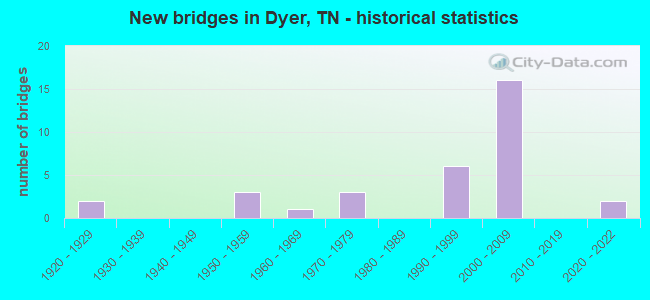
- New bridges - historical statistics
- 21920-1929
- 31950-1959
- 11960-1969
- 31970-1979
- 61990-1999
- 162000-2009
- 22020-2022
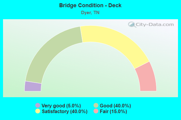
- Bridge Condition - Deck
- 5.0%Very good
- 40.0%Good
- 40.0%Satisfactory
- 15.0%Fair
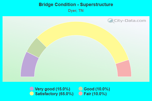
- Bridge Condition - Superstructure
- 15.0%Very good
- 10.0%Good
- 65.0%Satisfactory
- 10.0%Fair
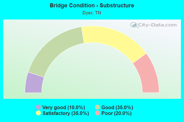
- Bridge Condition - Substructure
- 10.0%Very good
- 35.0%Good
- 35.0%Satisfactory
- 20.0%Poor
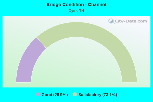
- Bridge Condition - Channel
- 26.9%Good
- 73.1%Satisfactory
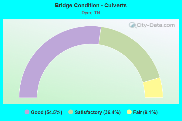
- Bridge Condition - Culverts
- 54.5%Good
- 36.4%Satisfactory
- 9.1%Fair
Find on map >> Show street view
Structure Number: 27014010005, Location: 2.8 MI NW JCT SR54&SR185 (Lat: 36.077889, Lng: -88.920444), Route carried "on" structure: County highway 1401, Year Built: 1992, Status: Open, Structure Length: 3.35m (10.99ft), Average Daily Traffic: 263 (year 2020), Truck Traffic: 5%, Average Future Daily Traffic: 432 (year 2039), Design Load: HS 20, Features Intersected: OVERFLOW
Minimum Vertical Clearance: 30+ m (98+ ft), Kilometerpoint: 5.182, Lanes on structure: 2, Owner: County Highway Agency, Approaching Roadway Width: 8.2m (26.9ft), Skew: 4 degrees, Material/Design: Prestressed concrete continuous, Design/Construction: Box Beam or Girders - Single/Spread, Number Of Spans In Main Unit: 3, Length of Maximum Span: 15.2m (49.9ft), Curb-To-Curb Width: 7.3m (24.0ft), Out-to-Out Width: 7.9m (25.9ft)
Condition: Deck: Good, Superstructure: Very good, Substructure: Good, Channel: Good, Operating Rating: 45.0 metric tons, Method Used To Determine Operating Rating: Load Factor (LF), Inventory Rating: 27.0 metric tons, Method Used To Determine Inventory Rating: Load Factor (LF), Structural Evaluation: Equal to present minimum criteria, Deck Geometry: Somewhat better than minimum adequacy, Waterway Adequacy: Better than present minimum criteria, Approach Roadway Alignment: Equal to present minimum criteria, Length Of Structure Improvement: 3.35m (10.99ft), Designated Inspection Frequency: Every 24 months, Inspection Date: July 2021, Bridge Improvement Cost: $501,000, Roadway Improvement Cost: $51,000, Total Project Cost: $752,000 ( Estimate for 2019), Deck Structure Type: Concrete Precast Panels, Wearing Surface/Protective System: Wearing Surface: Monolithic Concrete, Deck Protection: Epoxy Coated Reinforcing
Find on map >> Show street view
Structure Number: 27014010007, Location: 2.9 MI NW JCT SR54&SR185 (Lat: 36.076222, Lng: -88.921444), Route carried "on" structure: County highway 1401, Year Built: 2021, Status: Open, Structure Length: 2.29m (7.51ft), Average Daily Traffic: 263 (year 2020), Truck Traffic: 5%, Average Future Daily Traffic: 421 (year 2042), Design Load: HL 93, Features Intersected: OVERFLOW
Minimum Vertical Clearance: 30+ m (98+ ft), Kilometerpoint: 5.391, Lanes on structure: 2, Owner: County Highway Agency, Approaching Roadway Width: 7.3m (24.0ft), Material/Design: Prestressed concrete, Design/Construction: Box Beam or Girders - Single/Spread, Number Of Spans In Main Unit: 1, Length of Maximum Span: 22.9m (75.1ft), Curb-To-Curb Width: 7.9m (25.9ft), Out-to-Out Width: 8.6m (28.2ft)
Condition: Deck: Very good, Superstructure: Very good, Substructure: Very good, Channel: Satisfactory, Operating Rating: 54.1 metric tons, Method Used To Determine Operating Rating: Assigned ratings based on Load and Resistance Factor Design (LRFD) reported by rating factor (RF) using HL93 loadings, Inventory Rating: 32.4 metric tons, Method Used To Determine Inventory Rating: Assigned ratings based on Load and Resistance Factor Design (LRFD) reported by rating factor (RF) using HL93 loadings, Structural Evaluation: Equal to present desirable criteria, Deck Geometry: Somewhat better than minimum adequacy, Waterway Adequacy: Equal to present minimum criteria, Approach Roadway Alignment: Equal to present minimum criteria, Designated Inspection Frequency: Every 24 months, Inspection Date: July 2021, Deck Structure Type: Concrete Cast-file-Place, Wearing Surface/Protective System: Wearing Surface: Monolithic Concrete, Deck Protection: Epoxy Coated Reinforcing
Find on map >> Show street view
Structure Number: 27015940003, Location: 2.4 MI SW JCT SR5&SR185 (Lat: 36.029250, Lng: -88.994722), Route carried "on" structure: County highway 1594, Year Built: 1991, Status: Open, Structure Length: 1.49m (4.89ft), Average Daily Traffic: 305 (year 2020), Truck Traffic: 3%, Average Future Daily Traffic: 512 (year 2039), Design Load: HS 20, Features Intersected: BRANCH OF FORKED DEER RI
Minimum Vertical Clearance: 30+ m (98+ ft), Kilometerpoint: 4.120, Lanes on structure: 2, Owner: County Highway Agency, Approaching Roadway Width: 8.5m (27.9ft), Material/Design: Concrete continuous, Design/Construction: Culvert, Number Of Spans In Main Unit: 3, Length of Maximum Span: 4.6m (15.1ft), Curb-To-Curb Width: 8.5m (27.9ft), Out-to-Out Width: 9.8m (32.2ft)
Condition: Channel: Satisfactory, Culverts: Good, Operating Rating: 89.1 metric tons, Method Used To Determine Operating Rating: Load Factor (LF), Inventory Rating: 32.4 metric tons, Method Used To Determine Inventory Rating: Load Factor (LF), Structural Evaluation: Better than present minimum criteria, Deck Geometry: Equal to present minimum criteria, Waterway Adequacy: Equal to present minimum criteria, Approach Roadway Alignment: Equal to present minimum criteria, Designated Inspection Frequency: Every 24 months, Inspection Date: June 2021, Deck Structure Type: Concrete Cast-file-Place, Wearing Surface/Protective System: Wearing Surface: Monolithic Concrete, Deck Protection: Epoxy Coated Reinforcing
Find on map >> Show street view
Structure Number: 27015960001, Location: 2.2 MI E JCT SR5&SR77 (Lat: 36.072917, Lng: -88.961222), Route carried "on" structure: County highway 1596, Year Built: 2020, Status: Open, Structure Length: 3.05m (10.01ft), Average Daily Traffic: 275 (year 2020), Truck Traffic: 3%, Average Future Daily Traffic: 768 (year 2040), Design Load: HL 93, Features Intersected: BRANCH
Minimum Vertical Clearance: 30+ m (98+ ft), Kilometerpoint: 10.235, Lanes on structure: 2, Owner: County Highway Agency, Approaching Roadway Width: 7.9m (25.9ft), Material/Design: Prestressed concrete, Design/Construction: Box Beam or Girders - Single/Spread, Number Of Spans In Main Unit: 1, Length of Maximum Span: 30.5m (100.1ft), Curb-To-Curb Width: 7.9m (25.9ft), Out-to-Out Width: 8.6m (28.2ft)
Condition: Deck: Good, Superstructure: Very good, Substructure: Very good, Channel: Satisfactory, Operating Rating: 44.1 metric tons, Method Used To Determine Operating Rating: Assigned ratings based on Load and Resistance Factor Design (LRFD) reported by rating factor (RF) using HL93 loadings, Inventory Rating: 32.4 metric tons, Method Used To Determine Inventory Rating: Assigned ratings based on Load and Resistance Factor Design (LRFD) reported by rating factor (RF) using HL93 loadings, Structural Evaluation: Equal to present desirable criteria, Deck Geometry: Somewhat better than minimum adequacy, Waterway Adequacy: Better than present minimum criteria, Approach Roadway Alignment: Equal to present desirable criteria, Designated Inspection Frequency: Every 24 months, Inspection Date: July 2021, Deck Structure Type: Concrete Cast-file-Place, Wearing Surface/Protective System: Wearing Surface: Monolithic Concrete, Deck Protection: Epoxy Coated Reinforcing
Find on map >> Show street view
Structure Number: 27015960003, Location: 3.1 MI E JCT SR5&SR77 (Lat: 36.071111, Lng: -88.946278), Route carried "on" structure: County highway 1596, Year Built: 1965, Status: Posted for load, Structure Length: 2.04m (6.69ft), Average Daily Traffic: 275 (year 2020), Truck Traffic: 3%, Average Future Daily Traffic: 440 (year 2041), Design Load: H 10, Features Intersected: BRANCH
Minimum Vertical Clearance: 30+ m (98+ ft), Kilometerpoint: 11.587, Lanes on structure: 2, Owner: County Highway Agency, Approaching Roadway Width: 7.9m (25.9ft), Material/Design: Concrete, Design/Construction: Channel Beam, Number Of Spans In Main Unit: 3, Length of Maximum Span: 8.8m (28.9ft), Curb-To-Curb Width: 7.3m (24.0ft), Out-to-Out Width: 7.6m (24.9ft)
Condition: Deck: Satisfactory, Superstructure: Fair, Substructure: Poor, Channel: Satisfactory, Operating Rating: 16.2 metric tons, Method Used To Determine Operating Rating: Load and Resistance Factor Rating (LRFR) rating reported by rating factor(RF) method using HL-93 loadings, Inventory Rating: 12.6 metric tons, Method Used To Determine Inventory Rating: Load and Resistance Factor Rating (LRFR) rating reported by rating factor(RF) method using HL-93 loadings, Structural Evaluation: Meets minimum limits, Deck Geometry: Somewhat better than minimum adequacy, Waterway Adequacy: Better than present minimum criteria, Approach Roadway Alignment: Equal to present desirable criteria, Bridge Posting: Required (Relationship of Operating Rating to Maximum Legal Load: 0.1 - 9.9% below), Length Of Structure Improvement: 2.04m (6.69ft), Designated Inspection Frequency: Every 24 months, Inspection Date: July 2021, Bridge Improvement Cost: $123,000, Roadway Improvement Cost: $13,000, Total Project Cost: $185,000 ( Estimate for 2021), Deck Structure Type: Concrete Precast Panels, Wearing Surface/Protective System: Wearing Surface: Bituminous
Find on map >> Show street view
Structure Number: 270A0390001, Location: 3.7 MI SW JCT SR5&SR185 (Lat: 36.039611, Lng: -89.034083), Route carried "on" structure: County highway 39, Year Built: 1975, Status: Posted for load, Structure Length: 0.67m (2.20ft), Average Daily Traffic: 30 (year 2022), Truck Traffic: 2%, Average Future Daily Traffic: 48 (year 2040), Design Load: HS 15, Features Intersected: BR OF N FORK FORKED DEER
Minimum Vertical Clearance: 30+ m (98+ ft), Kilometerpoint: 2.268, Lanes on structure: 2, Owner: County Highway Agency, Approaching Roadway Width: 4.3m (14.1ft), Material/Design: Wood or Timber, Design/Construction: Stringer/Multi-beam, Number Of Spans In Main Unit: 1, Length of Maximum Span: 6.3m (20.7ft), Curb-To-Curb Width: 5.5m (18.0ft), Out-to-Out Width: 5.5m (18.0ft)
Condition: Deck: Fair, Superstructure: Satisfactory, Substructure: Satisfactory, Channel: Satisfactory, Operating Rating: 32.4 metric tons, Method Used To Determine Operating Rating: Field evaluation and documented engineering judgment, Inventory Rating: 18.0 metric tons, Method Used To Determine Inventory Rating: Field evaluation and documented engineering judgment, Structural Evaluation: Somewhat better than minimum adequacy, Deck Geometry: Meets minimum limits, Waterway Adequacy: Equal to present minimum criteria, Approach Roadway Alignment: Equal to present desirable criteria, Length Of Structure Improvement: 0.67m (2.20ft), Designated Inspection Frequency: Every 24 months, Inspection Date: June 2021, Bridge Improvement Cost: $104,000, Roadway Improvement Cost: $11,000, Total Project Cost: $157,000 ( Estimate for 2020), Deck Structure Type: Wood or Timber, Wearing Surface/Protective System: Wearing Surface: Gravel
Find on map >> Show street view
Structure Number: 270A0440001, Location: 2.8 MI SW JCT SR5&SR77 (Lat: 36.067694, Lng: -89.048833), Route carried "on" structure: County highway 44, Year Built: 2004, Status: Open, Structure Length: 1.16m (3.81ft), Average Daily Traffic: 100 (year 2022), Truck Traffic: 2%, Average Future Daily Traffic: 160 (year 2039), Design Load: HS 20, Features Intersected: COW CREEK
Minimum Vertical Clearance: 30+ m (98+ ft), Kilometerpoint: 1.405, Lanes on structure: 2, Owner: County Highway Agency, Approaching Roadway Width: 7.9m (25.9ft), Material/Design: Concrete, Design/Construction: Culvert, Number Of Spans In Main Unit: 2, Length of Maximum Span: 5.8m (19.0ft)
Condition: Channel: Satisfactory, Culverts: Good, Operating Rating: 54.0 metric tons, Method Used To Determine Operating Rating: Field evaluation and documented engineering judgment, Inventory Rating: 32.4 metric tons, Method Used To Determine Inventory Rating: Field evaluation and documented engineering judgment, Structural Evaluation: Better than present minimum criteria, Waterway Adequacy: Equal to present desirable criteria, Approach Roadway Alignment: Equal to present minimum criteria, Designated Inspection Frequency: Every 24 months, Inspection Date: June 2021, Wearing Surface/Protective System: Wearing Surface: Bituminous
Find on map >> Show street view
Structure Number: 270A0440003, Location: 2.9 MI SW JCT SR5&SR77 (Lat: 36.069028, Lng: -89.047667), Route carried "on" structure: County highway 44, Year Built: 1997, Status: Posted for load, Structure Length: 1.16m (3.81ft), Average Daily Traffic: 100 (year 2022), Truck Traffic: 2%, Average Future Daily Traffic: 160 (year 2041), Features Intersected: DRAINAGE DITCH - COW CR.
Minimum Vertical Clearance: 30+ m (98+ ft), Kilometerpoint: 1.588, Lanes on structure: 2, Owner: County Highway Agency, Approaching Roadway Width: 5.8m (19.0ft), Material/Design: Concrete, Design/Construction: Channel Beam, Number Of Spans In Main Unit: 2, Length of Maximum Span: 5.8m (19.0ft), Curb-To-Curb Width: 6.4m (21.0ft), Out-to-Out Width: 6.7m (22.0ft)
Condition: Deck: Fair, Superstructure: Satisfactory, Substructure: Satisfactory, Channel: Satisfactory, Operating Rating: 27.5 metric tons, Method Used To Determine Operating Rating: Load and Resistance Factor Rating (LRFR) rating reported by rating factor(RF) method using HL-93 loadings, Inventory Rating: 21.1 metric tons, Method Used To Determine Inventory Rating: Load and Resistance Factor Rating (LRFR) rating reported by rating factor(RF) method using HL-93 loadings, Structural Evaluation: Equal to present minimum criteria, Deck Geometry: Somewhat better than minimum adequacy, Waterway Adequacy: Equal to present minimum criteria, Approach Roadway Alignment: Equal to present desirable criteria, Designated Inspection Frequency: Every 24 months, Inspection Date: June 2021, Deck Structure Type: Concrete Precast Panels, Wearing Surface/Protective System: Wearing Surface: Bituminous
Find on map >> Show street view
Structure Number: 270A0440005, Location: 3.0 MI SW JCT SR5&SR77 (Lat: 36.070667, Lng: -89.046528), Route carried "on" structure: County highway 44, Year Built: 1972, Year Reconstructed: 2006, Status: Posted for load, Structure Length: 1.16m (3.81ft), Average Daily Traffic: 100 (year 2022), Truck Traffic: 2%, Average Future Daily Traffic: 160 (year 2041), Features Intersected: OVERFLOW-COW CREEK
Minimum Vertical Clearance: 30+ m (98+ ft), Kilometerpoint: 1.811, Lanes on structure: 2, Owner: County Highway Agency, Approaching Roadway Width: 7.3m (24.0ft), Material/Design: Concrete, Design/Construction: Channel Beam, Number Of Spans In Main Unit: 2, Length of Maximum Span: 5.8m (19.0ft), Curb-To-Curb Width: 7.3m (24.0ft), Out-to-Out Width: 7.7m (25.3ft)
Condition: Deck: Satisfactory, Superstructure: Satisfactory, Substructure: Poor, Channel: Good, Operating Rating: 32.1 metric tons, Method Used To Determine Operating Rating: Load and Resistance Factor Rating (LRFR) rating reported by rating factor(RF) method using HL-93 loadings, Inventory Rating: 24.6 metric tons, Method Used To Determine Inventory Rating: Load and Resistance Factor Rating (LRFR) rating reported by rating factor(RF) method using HL-93 loadings, Structural Evaluation: Meets minimum limits, Deck Geometry: Equal to present minimum criteria, Waterway Adequacy: Equal to present minimum criteria, Approach Roadway Alignment: Equal to present desirable criteria, Length Of Structure Improvement: 1.16m (3.81ft), Designated Inspection Frequency: Every 24 months, Inspection Date: June 2021, Bridge Improvement Cost: $163,000, Roadway Improvement Cost: $17,000, Total Project Cost: $245,000 ( Estimate for 2021), Deck Structure Type: Concrete Precast Panels, Wearing Surface/Protective System: Wearing Surface: Other
Find on map >> Show street view
Structure Number: 270A0460001, Location: 3.2 MI NW JCT SR5&SR77 (Lat: 36.089000, Lng: -89.051333), Route carried "on" structure: County highway 46, Year Built: 2007, Status: Open, Structure Length: 2.44m (8.01ft), Average Daily Traffic: 20 (year 2022), Truck Traffic: 2%, Average Future Daily Traffic: 32 (year 2039), Design Load: HS 20, Features Intersected: MUD CREEK
Minimum Vertical Clearance: 30+ m (98+ ft), Kilometerpoint: 2.467, Lanes on structure: 2, Owner: County Highway Agency, Approaching Roadway Width: 7.3m (24.0ft), Skew: 3 degrees, Material/Design: Prestressed concrete, Design/Construction: Stringer/Multi-beam, Number Of Spans In Main Unit: 1, Length of Maximum Span: 22.8m (74.8ft), Curb-To-Curb Width: 7.3m (24.0ft), Out-to-Out Width: 7.6m (24.9ft)
Condition: Deck: Good, Superstructure: Good, Substructure: Good, Channel: Satisfactory, Operating Rating: 80.2 metric tons, Method Used To Determine Operating Rating: Load Factor (LF), Inventory Rating: 32.4 metric tons, Method Used To Determine Inventory Rating: Load Factor (LF), Structural Evaluation: Better than present minimum criteria, Deck Geometry: Equal to present minimum criteria, Waterway Adequacy: Equal to present desirable criteria, Approach Roadway Alignment: Equal to present desirable criteria, Designated Inspection Frequency: Every 24 months, Inspection Date: June 2021, Deck Structure Type: Concrete Precast Panels, Wearing Surface/Protective System: Wearing Surface: Monolithic Concrete, Deck Protection: Epoxy Coated Reinforcing
Find on map >> Show street view
Structure Number: 270A0470001, Location: 3.5 MI NW JCT SR5&SR77 (Lat: 36.100194, Lng: -89.048611), Route carried "on" structure: County highway 47, Year Built: 2001, Status: Open, Structure Length: 1.98m (6.50ft), Average Daily Traffic: 90 (year 2022), Truck Traffic: 2%, Average Future Daily Traffic: 144 (year 2039), Design Load: HS 20, Features Intersected: MUD CREEK
Minimum Vertical Clearance: 30+ m (98+ ft), Kilometerpoint: 2.865, Lanes on structure: 2, Owner: County Highway Agency, Approaching Roadway Width: 8.5m (27.9ft), Skew: 1 degrees, Material/Design: Prestressed concrete, Design/Construction: Box Beam or Girders - Multiple, Number Of Spans In Main Unit: 1, Length of Maximum Span: 19.5m (64.0ft), Curb-To-Curb Width: 7.3m (24.0ft), Out-to-Out Width: 8.0m (26.2ft)
Condition: Deck: Good, Superstructure: Satisfactory, Substructure: Good, Channel: Satisfactory, Operating Rating: 80.6 metric tons, Method Used To Determine Operating Rating: Load Factor (LF), Inventory Rating: 32.4 metric tons, Method Used To Determine Inventory Rating: Load Factor (LF), Structural Evaluation: Equal to present minimum criteria, Deck Geometry: Equal to present minimum criteria, Waterway Adequacy: Better than present minimum criteria, Approach Roadway Alignment: Equal to present desirable criteria, Designated Inspection Frequency: Every 24 months, Inspection Date: June 2021, Deck Structure Type: Concrete Precast Panels, Wearing Surface/Protective System: Wearing Surface: Monolithic Concrete, Deck Protection: Epoxy Coated Reinforcing
Find on map >> Show street view
Structure Number: 270A1590001, Location: 3.2 MI NE JCT SR5&SR77 (Lat: 36.092306, Lng: -88.949750), Route carried "on" structure: County highway 159, Year Built: 1991, Status: Posted for load, Structure Length: 1.16m (3.81ft), Average Daily Traffic: 40 (year 2022), Truck Traffic: 2%, Average Future Daily Traffic: 64 (year 2041), Design Load: H 10, Features Intersected: OWEN BRANCH
Minimum Vertical Clearance: 30+ m (98+ ft), Kilometerpoint: 2.194, Lanes on structure: 2, Owner: County Highway Agency, Approaching Roadway Width: 7.0m (23.0ft), Material/Design: Concrete, Design/Construction: Channel Beam, Number Of Spans In Main Unit: 2, Length of Maximum Span: 5.8m (19.0ft), Curb-To-Curb Width: 6.4m (21.0ft), Out-to-Out Width: 6.7m (22.0ft)
Condition: Deck: Satisfactory, Superstructure: Fair, Substructure: Poor, Channel: Satisfactory, Operating Rating: 27.2 metric tons, Method Used To Determine Operating Rating: Load and Resistance Factor Rating (LRFR) rating reported by rating factor(RF) method using HL-93 loadings, Inventory Rating: 21.1 metric tons, Method Used To Determine Inventory Rating: Load and Resistance Factor Rating (LRFR) rating reported by rating factor(RF) method using HL-93 loadings, Structural Evaluation: Meets minimum limits, Deck Geometry: Somewhat better than minimum adequacy, Waterway Adequacy: Equal to present minimum criteria, Approach Roadway Alignment: Equal to present desirable criteria, Length Of Structure Improvement: 1.83m (6.00ft), Designated Inspection Frequency: Every 24 months, Inspection Date: June 2021, Bridge Improvement Cost: $321,000, Roadway Improvement Cost: $33,000, Total Project Cost: $482,000 ( Estimate for 2021), Deck Structure Type: Concrete Precast Panels, Wearing Surface/Protective System: Wearing Surface: Monolithic Concrete
Find on map >> Show street view
Structure Number: 270A1610001, Location: 2.6 MI NE JCT SR5&SR77 (Lat: 36.083611, Lng: -88.953639), Route carried "on" structure: County highway 161, Year Built: 2000, Status: Posted for load, Structure Length: 1.18m (3.87ft), Average Daily Traffic: 70 (year 2022), Truck Traffic: 2%, Average Future Daily Traffic: 112 (year 2040), Design Load: HS 15, Features Intersected: OWEN BRANCH
Minimum Vertical Clearance: 30+ m (98+ ft), Kilometerpoint: 2.134, Lanes on structure: 2, Owner: County Highway Agency, Approaching Roadway Width: 7.9m (25.9ft), Material/Design: Concrete, Design/Construction: Channel Beam, Number Of Spans In Main Unit: 2, Length of Maximum Span: 5.9m (19.4ft), Curb-To-Curb Width: 7.4m (24.3ft), Out-to-Out Width: 7.7m (25.3ft)
Condition: Deck: Satisfactory, Superstructure: Satisfactory, Substructure: Satisfactory, Channel: Satisfactory, Operating Rating: 36.0 metric tons, Method Used To Determine Operating Rating: Field evaluation and documented engineering judgment, Inventory Rating: 16.2 metric tons, Method Used To Determine Inventory Rating: Field evaluation and documented engineering judgment, Structural Evaluation: Somewhat better than minimum adequacy, Deck Geometry: Equal to present minimum criteria, Waterway Adequacy: Equal to present minimum criteria, Approach Roadway Alignment: Equal to present desirable criteria, Bridge Posting: Required (Relationship of Operating Rating to Maximum Legal Load: 0.1 - 9.9% below), Length Of Structure Improvement: 1.18m (3.87ft), Designated Inspection Frequency: Every 24 months, Inspection Date: June 2021, Bridge Improvement Cost: $166,000, Roadway Improvement Cost: $17,000, Total Project Cost: $250,000 ( Estimate for 2020), Deck Structure Type: Concrete Precast Panels, Wearing Surface/Protective System: Wearing Surface: Gravel
Find on map >> Show street view
Structure Number: 270A1610003, Location: 3.1 MI NE JCT SR5&SR77 (Lat: 36.077833, Lng: -88.943056), Route carried "on" structure: County highway 161, Year Built: 1992, Status: Posted for load, Structure Length: 1.16m (3.81ft), Average Daily Traffic: 70 (year 2022), Truck Traffic: 2%, Average Future Daily Traffic: 112 (year 2042), Design Load: H 15, Features Intersected: BR RUTHERFORD FORK OBION
Minimum Vertical Clearance: 30+ m (98+ ft), Kilometerpoint: 3.623, Lanes on structure: 2, Owner: County Highway Agency, Approaching Roadway Width: 6.1m (20.0ft), Material/Design: Concrete, Design/Construction: Channel Beam, Number Of Spans In Main Unit: 2, Length of Maximum Span: 5.8m (19.0ft), Curb-To-Curb Width: 6.4m (21.0ft), Out-to-Out Width: 6.7m (22.0ft)
Condition: Deck: Satisfactory, Superstructure: Satisfactory, Substructure: Poor, Channel: Satisfactory, Operating Rating: 4.5 metric tons, Method Used To Determine Operating Rating: Load and Resistance Factor Rating (LRFR) rating reported by rating factor(RF) method using HL-93 loadings, Inventory Rating: 3.2 metric tons, Method Used To Determine Inventory Rating: Load and Resistance Factor Rating (LRFR) rating reported by rating factor(RF) method using HL-93 loadings, Structural Evaluation: High priority of corrective action, Deck Geometry: Somewhat better than minimum adequacy, Waterway Adequacy: Equal to present minimum criteria, Approach Roadway Alignment: Equal to present desirable criteria, Bridge Posting: Required (Relationship of Operating Rating to Maximum Legal Load: 10.0 - 19.9% below), Length Of Structure Improvement: 1.16m (3.81ft), Designated Inspection Frequency: Every 24 months, Inspection Date: July 2021, Bridge Improvement Cost: $163,000, Roadway Improvement Cost: $17,000, Total Project Cost: $245,000 ( Estimate for 2022), Deck Structure Type: Concrete Precast Panels, Wearing Surface/Protective System: Wearing Surface: Monolithic Concrete
Find on map >> Show street view
Structure Number: 270A1990001, Location: 1.2 MI SW JCT SR5&SR77 (Lat: 36.068917, Lng: -89.016139), Route carried "on" structure: County highway 199, Year Built: 1972, Status: Posted for load, Structure Length: 1.74m (5.71ft), Average Daily Traffic: 560 (year 2018), Truck Traffic: 2%, Average Future Daily Traffic: 896 (year 2039), Design Load: H 15, Features Intersected: SAND CREEK
Minimum Vertical Clearance: 30+ m (98+ ft), Kilometerpoint: 2.021, Lanes on structure: 2, Owner: County Highway Agency, Approaching Roadway Width: 7.6m (24.9ft), Skew: 2 degrees, Material/Design: Concrete, Design/Construction: Channel Beam, Number Of Spans In Main Unit: 3, Length of Maximum Span: 5.8m (19.0ft), Curb-To-Curb Width: 6.4m (21.0ft), Out-to-Out Width: 6.7m (22.0ft)
Condition: Deck: Satisfactory, Superstructure: Satisfactory, Substructure: Satisfactory, Channel: Satisfactory, Operating Rating: 16.2 metric tons, Method Used To Determine Operating Rating: Allowable Stress (AS), Inventory Rating: 16.2 metric tons, Method Used To Determine Inventory Rating: Allowable Stress (AS), Structural Evaluation: Meets minimum limits, Deck Geometry: High priority of corrective action, Waterway Adequacy: Equal to present minimum criteria, Approach Roadway Alignment: Equal to present desirable criteria, Bridge Posting: Required (Relationship of Operating Rating to Maximum Legal Load: 0.1 - 9.9% below), Length Of Structure Improvement: 2.44m (8.01ft), Designated Inspection Frequency: Every 24 months, Inspection Date: June 2021, Bridge Improvement Cost: $493,000, Roadway Improvement Cost: $50,000, Total Project Cost: $740,000 ( Estimate for 2019), Deck Structure Type: Concrete Precast Panels, Wearing Surface/Protective System: Wearing Surface: Bituminous
Find on map >> Show street view
Structure Number: 270A2100001, Location: 0.1MI S OF SR 5 (Lat: 36.057111, Lng: -89.001389), Route carried "on" structure: County highway 210, Year Built: 2000, Status: Open, Structure Length: 0.71m (2.33ft), Average Daily Traffic: 560 (year 2018), Truck Traffic: 2%, Average Future Daily Traffic: 896 (year 2039), Design Load: HS 20, Features Intersected: COW CREEK
Minimum Vertical Clearance: 30+ m (98+ ft), Kilometerpoint: 3.439, Lanes on structure: 2, Owner: County Highway Agency, Approaching Roadway Width: 8.5m (27.9ft), Skew: 3 degrees, Material/Design: Concrete continuous, Design/Construction: Culvert, Number Of Spans In Main Unit: 2, Length of Maximum Span: 3.5m (11.5ft)
Condition: Channel: Satisfactory, Culverts: Good, Operating Rating: 54.0 metric tons, Method Used To Determine Operating Rating: Field evaluation and documented engineering judgment, Inventory Rating: 32.4 metric tons, Method Used To Determine Inventory Rating: Field evaluation and documented engineering judgment, Structural Evaluation: Better than present minimum criteria, Waterway Adequacy: Better than present minimum criteria, Approach Roadway Alignment: Equal to present desirable criteria, Designated Inspection Frequency: Every 24 months, Inspection Date: June 2021, Wearing Surface/Protective System: Deck Protection: Epoxy Coated Reinforcing
Find on map >> Show street view
Structure Number: 27SR0050025, Location: IN DYER CITY LIMITS (Lat: 36.049389, Lng: -88.980306), Route carried "on" structure: City street 2483, Year Built: 1929, Status: Open, Structure Length: 0.67m (2.20ft), Average Daily Traffic: 2,880 (year 2020), Truck Traffic: 3%, Average Future Daily Traffic: 4,704 (year 2039), Design Load: H 15, Features Intersected: BRANCH
Minimum Vertical Clearance: 30+ m (98+ ft), Kilometerpoint: 5.633, Lanes on structure: 2, Owner: City or Municipal Highway Agency, Approaching Roadway Width: 11.0m (36.1ft), Material/Design: Concrete continuous, Design/Construction: Culvert, Number Of Spans In Main Unit: 2, Length of Maximum Span: 3.1m (10.2ft)
Condition: Channel: Satisfactory, Culverts: Fair, Operating Rating: 32.4 metric tons, Method Used To Determine Operating Rating: Load Factor (LF), Inventory Rating: 24.3 metric tons, Method Used To Determine Inventory Rating: Load Factor (LF), Structural Evaluation: Somewhat better than minimum adequacy, Waterway Adequacy: Equal to present minimum criteria, Approach Roadway Alignment: Equal to present desirable criteria, Length Of Structure Improvement: 0.67m (2.20ft), Designated Inspection Frequency: Every 24 months, Inspection Date: June 2021, Bridge Improvement Cost: $149,000, Roadway Improvement Cost: $15,000, Total Project Cost: $224,000 ( Estimate for 2019)
Find on map >> Show street view
Structure Number: 27SR0050027, Location: IN DYER CITY LIMITS (Lat: 36.061833, Lng: -88.990361), Route carried "on" structure: State highway 185, Year Built: 1958, Status: Open, Structure Length: 4.79m (15.72ft), Average Daily Traffic: 3,025 (year 2020), Truck Traffic: 4%, Average Future Daily Traffic: 5,552 (year 2039), Design Load: HS 20, Features Intersected: W TENN RAILROAD
Minimum Vertical Clearance: 30+ m (98+ ft), Kilometerpoint: 2.189, Lanes on structure: 2, Owner: State Highway Agency, Approaching Roadway Width: 11.0m (36.1ft), Skew: 4 degrees, Material/Design: Concrete, Design/Construction: Tee Beam, Number Of Spans In Main Unit: 5, Length of Maximum Span: 13.1m (43.0ft), Curb or Sidewalk Widths: Left: 1.5m (4.9ft), Right: 1.5m (4.9ft), Curb-To-Curb Width: 8.5m (27.9ft), Out-to-Out Width: 12.2m (40.0ft)
Condition: Deck: Satisfactory, Superstructure: Satisfactory, Substructure: Satisfactory, Operating Rating: 70.2 metric tons, Method Used To Determine Operating Rating: Load Factor (LF), Inventory Rating: 32.4 metric tons, Method Used To Determine Inventory Rating: Load Factor (LF), Structural Evaluation: Equal to present minimum criteria, Deck Geometry: Meets minimum limits, Underclear: Somewhat better than minimum adequacy, Approach Roadway Alignment: Equal to present desirable criteria, Length Of Structure Improvement: 4.79m (15.72ft), Designated Inspection Frequency: Every 24 months, Inspection Date: June 2021, Bridge Improvement Cost: $481,000, Roadway Improvement Cost: $49,000, Total Project Cost: $722,000 ( Estimate for 2019), Deck Structure Type: Concrete Cast-file-Place, Wearing Surface/Protective System: Wearing Surface: Bituminous
Find on map >> Show street view
Structure Number: 27SR0050029, Location: IN DYER CITY LIMITS (Lat: 36.072694, Lng: -88.997944), Route carried "on" structure: State highway 185, Year Built: 1929, Status: Open, Structure Length: 0.67m (2.20ft), Average Daily Traffic: 3,025 (year 2020), Truck Traffic: 4%, Average Future Daily Traffic: 5,552 (year 2039), Design Load: H 15, Features Intersected: SAND CREEK
Minimum Vertical Clearance: 30+ m (98+ ft), Kilometerpoint: 0.805, Lanes on structure: 2, Owner: State Highway Agency, Approaching Roadway Width: 12.2m (40.0ft), Material/Design: Concrete continuous, Design/Construction: Culvert, Number Of Spans In Main Unit: 2, Length of Maximum Span: 3.1m (10.2ft)
Condition: Channel: Good, Culverts: Satisfactory, Operating Rating: 32.4 metric tons, Method Used To Determine Operating Rating: Load Factor (LF), Inventory Rating: 24.3 metric tons, Method Used To Determine Inventory Rating: Load Factor (LF), Structural Evaluation: Equal to present minimum criteria, Waterway Adequacy: Equal to present desirable criteria, Approach Roadway Alignment: Equal to present desirable criteria, Length Of Structure Improvement: 0.67m (2.20ft), Designated Inspection Frequency: Every 24 months, Inspection Date: June 2021, Bridge Improvement Cost: $149,000, Roadway Improvement Cost: $15,000, Total Project Cost: $224,000 ( Estimate for 2019)
Find on map >> Show street view
Structure Number: 27SR0050045, Location: IN DYER CITY LIMITS (Lat: 36.073778, Lng: -89.006389), Route carried "on" structure: US 45, Year Built: 2000, Status: Open, Structure Length: 3.18m (10.43ft), Average Daily Traffic: 3,775 (year 2020), Truck Traffic: 7%, Average Future Daily Traffic: 7,632 (year 2039), Design Load: HS 20, Features Intersected: SR 5 / SR 77, Facility Carried by Structure: FAP 5
Minimum Vertical Clearance: 30+ m (98+ ft), Kilometerpoint: 37.385, Lanes on structure: 2, Lanes under structure: 2, Base Highway Network: Yes, Owner: State Highway Agency, Approaching Roadway Width: 11.6m (38.1ft), Material/Design: Prestressed concrete, Design/Construction: Box Beam or Girders - Single/Spread, Number Of Spans In Main Unit: 1, Length of Maximum Span: 30.8m (101.0ft), Curb-To-Curb Width: 12.5m (41.0ft), Out-to-Out Width: 13.1m (43.0ft)
Condition: Deck: Good, Superstructure: Good, Substructure: Good, Operating Rating: 44.1 metric tons, Method Used To Determine Operating Rating: Assigned rating based on Load Factor Design (LFD) reported in metric tons, Inventory Rating: 32.4 metric tons, Method Used To Determine Inventory Rating: Assigned rating based on Load Factor Design (LFD) reported in metric tons, Structural Evaluation: Better than present minimum criteria, Deck Geometry: Better than present minimum criteria, Underclear: Superior to present desirable criteria, Approach Roadway Alignment: Equal to present desirable criteria, Designated Inspection Frequency: Every 24 months, Inspection Date: June 2021, Deck Structure Type: Concrete Cast-file-Place, Wearing Surface/Protective System: Wearing Surface: Monolithic Concrete, Deck Protection: Epoxy Coated Reinforcing
Find on map >> Show street view
Structure Number: 27SR0050046, Location: IN DYER CITY LIMITS (Lat: 36.073778, Lng: -89.006611), Route carried "on" structure: US 45, Year Built: 2000, Status: Open, Structure Length: 3.13m (10.27ft), Average Daily Traffic: 3,775 (year 2020), Truck Traffic: 7%, Average Future Daily Traffic: 6,040 (year 2042), Design Load: HS 20, Features Intersected: SR 5 / SR 77, Facility Carried by Structure: FAP 5
Minimum Vertical Clearance: 30+ m (98+ ft), Kilometerpoint: 37.385, Lanes on structure: 2, Lanes under structure: 2, Base Highway Network: Yes, Owner: State Highway Agency, Approaching Roadway Width: 11.6m (38.1ft), Material/Design: Prestressed concrete, Design/Construction: Box Beam or Girders - Single/Spread, Number Of Spans In Main Unit: 1, Length of Maximum Span: 30.8m (101.0ft), Curb-To-Curb Width: 12.5m (41.0ft), Out-to-Out Width: 13.1m (43.0ft)
Condition: Deck: Good, Superstructure: Satisfactory, Substructure: Good, Operating Rating: 89.1 metric tons, Method Used To Determine Operating Rating: Load Factor (LF), Inventory Rating: 32.4 metric tons, Method Used To Determine Inventory Rating: Load Factor (LF), Structural Evaluation: Equal to present minimum criteria, Deck Geometry: Better than present minimum criteria, Underclear: Superior to present desirable criteria, Approach Roadway Alignment: Equal to present desirable criteria, Designated Inspection Frequency: Every 24 months, Inspection Date: June 2021, Deck Structure Type: Concrete Cast-file-Place, Wearing Surface/Protective System: Wearing Surface: Monolithic Concrete, Deck Protection: Epoxy Coated Reinforcing
Find on map >> Show street view
Structure Number: 27SR0050047, Location: 6.5 MI N OF SR 104 (Lat: 36.044389, Lng: -88.984889), Route carried "on" structure: US 45, Year Built: 2000, Status: Open, Structure Length: 5.15m (16.90ft), Average Daily Traffic: 3,775 (year 2020), Truck Traffic: 7%, Average Future Daily Traffic: 6,040 (year 2042), Design Load: HS 20, Features Intersected: WEST TN RAILROAD, Facility Carried by Structure: FAP 5
Minimum Vertical Clearance: 30+ m (98+ ft), Kilometerpoint: 33.410, Lanes on structure: 2, Base Highway Network: Yes, Owner: State Highway Agency, Approaching Roadway Width: 12.8m (42.0ft), Skew: 2 degrees, Material/Design: Prestressed concrete continuous, Design/Construction: Box Beam or Girders - Single/Spread, Number Of Spans In Main Unit: 3, Length of Maximum Span: 18.1m (59.4ft), Curb-To-Curb Width: 12.5m (41.0ft), Out-to-Out Width: 13.1m (43.0ft)
Condition: Deck: Good, Superstructure: Satisfactory, Substructure: Good, Operating Rating: 44.1 metric tons, Method Used To Determine Operating Rating: Assigned rating based on Load Factor Design (LFD) reported in metric tons, Inventory Rating: 32.4 metric tons, Method Used To Determine Inventory Rating: Assigned rating based on Load Factor Design (LFD) reported in metric tons, Structural Evaluation: Equal to present minimum criteria, Deck Geometry: Better than present minimum criteria, Underclear: Superior to present desirable criteria, Approach Roadway Alignment: Equal to present desirable criteria, Designated Inspection Frequency: Every 24 months, Inspection Date: June 2021, Deck Structure Type: Concrete Precast Panels, Wearing Surface/Protective System: Wearing Surface: Monolithic Concrete, Deck Protection: Epoxy Coated Reinforcing
Find on map >> Show street view
Structure Number: 27SR0050048, Location: 6.5 MI N OF SR 104 (Lat: 36.044167, Lng: -88.985000), Route carried "on" structure: US 45, Year Built: 2000, Status: Open, Structure Length: 5.15m (16.90ft), Average Daily Traffic: 3,775 (year 2020), Truck Traffic: 7%, Average Future Daily Traffic: 6,040 (year 2042), Design Load: HS 20, Features Intersected: WEST TN RAILROAD, Facility Carried by Structure: FAP 5
Minimum Vertical Clearance: 30+ m (98+ ft), Kilometerpoint: 33.410, Lanes on structure: 2, Base Highway Network: Yes, Owner: State Highway Agency, Approaching Roadway Width: 12.8m (42.0ft), Skew: 2 degrees, Material/Design: Prestressed concrete continuous, Design/Construction: Box Beam or Girders - Single/Spread, Number Of Spans In Main Unit: 3, Length of Maximum Span: 18.1m (59.4ft), Curb-To-Curb Width: 12.5m (41.0ft), Out-to-Out Width: 13.1m (43.0ft)
Condition: Deck: Good, Superstructure: Satisfactory, Substructure: Good, Operating Rating: 63.2 metric tons, Method Used To Determine Operating Rating: Load Factor (LF), Inventory Rating: 32.4 metric tons, Method Used To Determine Inventory Rating: Load Factor (LF), Structural Evaluation: Equal to present minimum criteria, Deck Geometry: Better than present minimum criteria, Underclear: Superior to present desirable criteria, Approach Roadway Alignment: Equal to present desirable criteria, Designated Inspection Frequency: Every 24 months, Inspection Date: June 2021, Deck Structure Type: Concrete Precast Panels, Wearing Surface/Protective System: Wearing Surface: Monolithic Concrete, Deck Protection: Epoxy Coated Reinforcing
Find on map >> Show street view
Structure Number: 27SR0050053, Location: 6 MI N OF SR 104 (Lat: 36.044194, Lng: -88.984722), Route carried "on" structure: US 45, Year Built: 2001, Status: Open, Structure Length: 0.89m (2.92ft), Average Daily Traffic: 3,775 (year 2020), Truck Traffic: 7%, Average Future Daily Traffic: 7,632 (year 2039), Design Load: HS 20, Features Intersected: BRANCH, Facility Carried by Structure: FAP 5
Minimum Vertical Clearance: 30+ m (98+ ft), Kilometerpoint: 33.378, Lanes on structure: 4, Base Highway Network: Yes, Owner: State Highway Agency, Approaching Roadway Width: 25.6m (84.0ft), Skew: 21 degrees, Material/Design: Concrete continuous, Design/Construction: Culvert, Number Of Spans In Main Unit: 2, Length of Maximum Span: 3.1m (10.2ft)
Condition: Channel: Satisfactory, Culverts: Good, Operating Rating: 89.1 metric tons, Method Used To Determine Operating Rating: Load Factor (LF), Inventory Rating: 32.4 metric tons, Method Used To Determine Inventory Rating: Load Factor (LF), Structural Evaluation: Better than present minimum criteria, Waterway Adequacy: Equal to present desirable criteria, Approach Roadway Alignment: Equal to present desirable criteria, Length Of Structure Improvement: 0.89m (2.92ft), Designated Inspection Frequency: Every 24 months, Inspection Date: June 2021, Bridge Improvement Cost: $289,000, Roadway Improvement Cost: $29,000, Total Project Cost: $434,000 ( Estimate for 2019)
Find on map >> Show street view
Structure Number: 27SR0050059, Location: 5 MI N OF SR 104 (Lat: 36.032528, Lng: -88.975667), Route carried "on" structure: US 45, Year Built: 2001, Status: Open, Structure Length: 0.85m (2.79ft), Average Daily Traffic: 3,775 (year 2020), Truck Traffic: 7%, Average Future Daily Traffic: 7,632 (year 2039), Design Load: HS 20, Features Intersected: BRANCH, Facility Carried by Structure: FAP 5
Minimum Vertical Clearance: 30+ m (98+ ft), Kilometerpoint: 31.833, Lanes on structure: 4, Base Highway Network: Yes, Owner: State Highway Agency, Approaching Roadway Width: 17.7m (58.1ft), Skew: 23 degrees, Material/Design: Concrete continuous, Design/Construction: Culvert, Number Of Spans In Main Unit: 2, Length of Maximum Span: 4.2m (13.8ft)
Condition: Channel: Good, Culverts: Good, Operating Rating: 54.0 metric tons, Method Used To Determine Operating Rating: Field evaluation and documented engineering judgment, Inventory Rating: 32.4 metric tons, Method Used To Determine Inventory Rating: Field evaluation and documented engineering judgment, Structural Evaluation: Better than present minimum criteria, Waterway Adequacy: Equal to present desirable criteria, Approach Roadway Alignment: Equal to present desirable criteria, Length Of Structure Improvement: 0.85m (2.79ft), Designated Inspection Frequency: Every 24 months, Inspection Date: June 2021, Bridge Improvement Cost: $280,000, Roadway Improvement Cost: $29,000, Total Project Cost: $421,000 ( Estimate for 2019)
Find on map >> Show street view
Structure Number: 27SR0050063, Location: 6.5 MI N OF SR 104 (Lat: 36.046278, Lng: -88.987111), Route carried "on" structure: US 45, Year Built: 2001, Status: Open, Structure Length: 0.90m (2.95ft), Average Daily Traffic: 3,775 (year 2020), Truck Traffic: 7%, Average Future Daily Traffic: 6,040 (year 2042), Design Load: HS 20, Features Intersected: BRANCH, Facility Carried by Structure: FAP 5
Minimum Vertical Clearance: 30+ m (98+ ft), Kilometerpoint: 33.700, Lanes on structure: 4, Base Highway Network: Yes, Owner: State Highway Agency, Approaching Roadway Width: 24.6m (80.7ft), Skew: 24 degrees, Material/Design: Concrete continuous, Design/Construction: Culvert, Number Of Spans In Main Unit: 2, Length of Maximum Span: 4.3m (14.1ft)
Condition: Channel: Good, Culverts: Satisfactory, Operating Rating: 89.1 metric tons, Method Used To Determine Operating Rating: Load Factor (LF), Inventory Rating: 32.4 metric tons, Method Used To Determine Inventory Rating: Load Factor (LF), Structural Evaluation: Equal to present minimum criteria, Waterway Adequacy: Equal to present desirable criteria, Approach Roadway Alignment: Equal to present desirable criteria, Length Of Structure Improvement: 0.90m (2.95ft), Designated Inspection Frequency: Every 24 months, Inspection Date: June 2021, Bridge Improvement Cost: $295,000, Roadway Improvement Cost: $30,000, Total Project Cost: $443,000 ( Estimate for 2022)
Find on map >> Show street view
Structure Number: 27SR0050065, Location: 7.5 MI N OF SR 104 (Lat: 36.057111, Lng: -88.999500), Route carried "on" structure: US 45, Year Built: 2001, Status: Open, Structure Length: 0.82m (2.69ft), Average Daily Traffic: 3,775 (year 2020), Truck Traffic: 7%, Average Future Daily Traffic: 6,040 (year 2042), Design Load: HS 20, Features Intersected: BRANCH, Facility Carried by Structure: FAP 5
Minimum Vertical Clearance: 30+ m (98+ ft), Kilometerpoint: 35.357, Lanes on structure: 4, Base Highway Network: Yes, Owner: State Highway Agency, Approaching Roadway Width: 24.4m (80.1ft), Skew: 24 degrees, Material/Design: Concrete continuous, Design/Construction: Culvert, Number Of Spans In Main Unit: 2, Length of Maximum Span: 4.1m (13.5ft)
Condition: Channel: Good, Culverts: Satisfactory, Operating Rating: 54.0 metric tons, Method Used To Determine Operating Rating: Field evaluation and documented engineering judgment, Inventory Rating: 32.4 metric tons, Method Used To Determine Inventory Rating: Field evaluation and documented engineering judgment, Structural Evaluation: Equal to present minimum criteria, Waterway Adequacy: Equal to present desirable criteria, Approach Roadway Alignment: Equal to present desirable criteria, Length Of Structure Improvement: 0.82m (2.69ft), Designated Inspection Frequency: Every 24 months, Inspection Date: June 2021, Bridge Improvement Cost: $271,000, Roadway Improvement Cost: $28,000, Total Project Cost: $407,000 ( Estimate for 2022)
Find on map >> Show street view
Structure Number: 27SR0050067, Location: IN DYER CITY LIMITS (Lat: 36.072833, Lng: -89.006694), Route carried "on" structure: US 45, Year Built: 2001, Status: Open, Structure Length: 0.82m (2.69ft), Average Daily Traffic: 3,775 (year 2020), Truck Traffic: 7%, Average Future Daily Traffic: 6,040 (year 2042), Design Load: HS 20, Features Intersected: SAND CREEK, Facility Carried by Structure: FAP 5
Minimum Vertical Clearance: 30+ m (98+ ft), Kilometerpoint: 37.273, Lanes on structure: 4, Base Highway Network: Yes, Owner: State Highway Agency, Approaching Roadway Width: 24.4m (80.1ft), Skew: 20 degrees, Material/Design: Concrete continuous, Design/Construction: Culvert, Number Of Spans In Main Unit: 2, Length of Maximum Span: 3.7m (12.1ft)
Condition: Channel: Satisfactory, Culverts: Satisfactory, Operating Rating: 54.0 metric tons, Method Used To Determine Operating Rating: Field evaluation and documented engineering judgment, Inventory Rating: 32.4 metric tons, Method Used To Determine Inventory Rating: Field evaluation and documented engineering judgment, Structural Evaluation: Equal to present minimum criteria, Waterway Adequacy: Equal to present desirable criteria, Approach Roadway Alignment: Equal to present desirable criteria, Length Of Structure Improvement: 0.82m (2.69ft), Designated Inspection Frequency: Every 24 months, Inspection Date: June 2021, Bridge Improvement Cost: $270,000, Roadway Improvement Cost: $28,000, Total Project Cost: $406,000 ( Estimate for 2022)
Find on map >> Show street view
Structure Number: 27SR0050069, Location: IN DYER CITY LIMITS (Lat: 36.072833, Lng: -88.007972), Route carried "on" structure: US 45, Year Built: 2001, Status: Open, Structure Length: 0.82m (2.69ft), Average Daily Traffic: 3,775 (year 2020), Truck Traffic: 7%, Average Future Daily Traffic: 7,632 (year 2039), Design Load: HS 20, Features Intersected: BRANCH, Facility Carried by Structure: FAP 5
Minimum Vertical Clearance: 30+ m (98+ ft), Kilometerpoint: 37.321, Lanes on structure: 4, Base Highway Network: Yes, Owner: State Highway Agency, Approaching Roadway Width: 21.7m (71.2ft), Skew: 10 degrees, Material/Design: Concrete continuous, Design/Construction: Culvert, Number Of Spans In Main Unit: 2, Length of Maximum Span: 3.7m (12.1ft)
Condition: Channel: Satisfactory, Culverts: Good, Operating Rating: 54.0 metric tons, Method Used To Determine Operating Rating: Field evaluation and documented engineering judgment, Inventory Rating: 32.4 metric tons, Method Used To Determine Inventory Rating: Field evaluation and documented engineering judgment, Structural Evaluation: Better than present minimum criteria, Waterway Adequacy: Equal to present desirable criteria, Approach Roadway Alignment: Equal to present desirable criteria, Length Of Structure Improvement: 0.82m (2.69ft), Designated Inspection Frequency: Every 24 months, Inspection Date: June 2021, Bridge Improvement Cost: $270,000, Roadway Improvement Cost: $28,000, Total Project Cost: $406,000 ( Estimate for 2019)
Find on map >> Show street view
Structure Number: 27SR0770007, Location: 3 MILES WEST OF DYER (Lat: 36.076583, Lng: -89.054722), Route carried "on" structure: State highway 77, Year Built: 1954, Status: Open, Structure Length: 2.50m (8.20ft), Average Daily Traffic: 1,490 (year 2020), Truck Traffic: 4%, Average Future Daily Traffic: 2,800 (year 2040), Design Load: H 20, Features Intersected: MUD CREEK
Minimum Vertical Clearance: 30+ m (98+ ft), Kilometerpoint: 10.131, Lanes on structure: 2, Owner: State Highway Agency, Approaching Roadway Width: 7.9m (25.9ft), Material/Design: Concrete, Design/Construction: Tee Beam, Number Of Spans In Main Unit: 3, Length of Maximum Span: 8.5m (27.9ft), Curb-To-Curb Width: 7.9m (25.9ft), Out-to-Out Width: 9.8m (32.2ft)
Condition: Deck: Satisfactory, Superstructure: Satisfactory, Substructure: Satisfactory, Channel: Satisfactory, Operating Rating: 63.9 metric tons, Method Used To Determine Operating Rating: Load Factor (LF), Inventory Rating: 32.4 metric tons, Method Used To Determine Inventory Rating: Load Factor (LF), Structural Evaluation: Equal to present minimum criteria, Deck Geometry: Meets minimum limits, Waterway Adequacy: Equal to present desirable criteria, Approach Roadway Alignment: Equal to present desirable criteria, Length Of Structure Improvement: 2.50m (8.20ft), Designated Inspection Frequency: Every 24 months, Inspection Date: June 2021, Bridge Improvement Cost: $430,000, Roadway Improvement Cost: $44,000, Total Project Cost: $646,000 ( Estimate for 2020), Deck Structure Type: Concrete Cast-file-Place, Wearing Surface/Protective System: Wearing Surface: Bituminous
Find on map >> Show street view
Structure Number: 27SR0770009, Location: 3 MILES WEST OF DYER (Lat: 36.076806, Lng: -89.053361), Route carried "on" structure: State highway 77, Year Built: 1954, Status: Posted for load, Structure Length: 2.50m (8.20ft), Average Daily Traffic: 1,490 (year 2020), Truck Traffic: 4%, Average Future Daily Traffic: 2,640 (year 2040), Design Load: H 15, Features Intersected: OVERFLOW
Minimum Vertical Clearance: 30+ m (98+ ft), Kilometerpoint: 10.244, Lanes on structure: 2, Owner: State Highway Agency, Approaching Roadway Width: 9.4m (30.8ft), Material/Design: Concrete, Design/Construction: Tee Beam, Number Of Spans In Main Unit: 3, Length of Maximum Span: 8.5m (27.9ft), Curb-To-Curb Width: 7.9m (25.9ft), Out-to-Out Width: 9.4m (30.8ft)
Condition: Deck: Fair, Superstructure: Satisfactory, Substructure: Satisfactory, Channel: Good, Operating Rating: 35.0 metric tons, Method Used To Determine Operating Rating: Load and Resistance Factor Rating (LRFR) rating reported by rating factor(RF) method using HL-93 loadings, Inventory Rating: 26.9 metric tons, Method Used To Determine Inventory Rating: Load and Resistance Factor Rating (LRFR) rating reported by rating factor(RF) method using HL-93 loadings, Structural Evaluation: Equal to present minimum criteria, Deck Geometry: Meets minimum limits, Waterway Adequacy: Equal to present desirable criteria, Approach Roadway Alignment: Equal to present desirable criteria, Length Of Structure Improvement: 2.50m (8.20ft), Designated Inspection Frequency: Every 24 months, Inspection Date: June 2021, Bridge Improvement Cost: $155,000, Roadway Improvement Cost: $16,000, Total Project Cost: $233,000 ( Estimate for 2020), Deck Structure Type: Concrete Cast-file-Place, Wearing Surface/Protective System: Wearing Surface: Bituminous
Find on map >> Show street view
Structure Number: 27SR0050045, Location: IN DYER CITY LIMITS (Lat: 36.073778, Lng: -89.006389), Route carried "under" structure: State highway 77, Year Built: 1998, Structure Length: 0. m, Average Daily Traffic: 1,490 (year 2020), Truck Traffic: 4%, Features Intersected: SR 5 / SR 77
Minimum Vertical Clearance: 5.16m (16.93ft), Kilometerpoint: 14.267, Lanes on structure: 2, Lanes under structure: 2, Material/Design: Prestressed concrete, Design/Construction: Stringer/Multi-beam, Length of Maximum Span: 30.8m (101.0ft)
Find on map >> Show street view
Structure Number: 27SR0050046, Location: IN DYER CITY LIMITS (Lat: 36.073778, Lng: -89.006611), Route carried "under" structure: State highway 77, Year Built: 2000, Structure Length: 0. m, Average Daily Traffic: 1,490 (year 2020), Truck Traffic: 4%, Features Intersected: SR 5/ SR 77
Minimum Vertical Clearance: 5.28m (17.32ft), Kilometerpoint: 14.251, Lanes on structure: 2, Lanes under structure: 2, Material/Design: Prestressed concrete, Design/Construction: Stringer/Multi-beam, Length of Maximum Span: 30.8m (101.0ft)