Bridge Statistics for East Greenville, Pennsylvania (PA)
Condition, Traffic, Stress, Structural Evaluation, Project Costs
- National Bridge Inventory (NBI) Statistics
- 16Number of bridges
- 144ft / 43.8mTotal length
- $4,371,000Total costs
- 79,932Total average daily traffic
- 14,827Total average daily truck traffic
- 86,900Total future (year 2009) average daily traffic
- National Bridge Inventory (NBI) Registered Bridges for East Greenville
- No street view available for this location
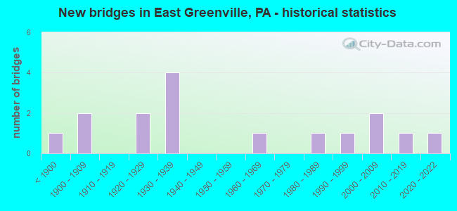
- New bridges - historical statistics
- 1Before 1900
- 21900-1909
- 21920-1929
- 41930-1939
- 11960-1969
- 11980-1989
- 11990-1999
- 22000-2009
- 12010-2019
- 12020-2022
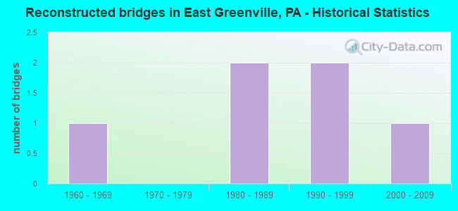
- Reconstructed bridges - Historical Statistics
- 11960-1969
- 01970-1979
- 21980-1989
- 21990-1999
- 12000-2009
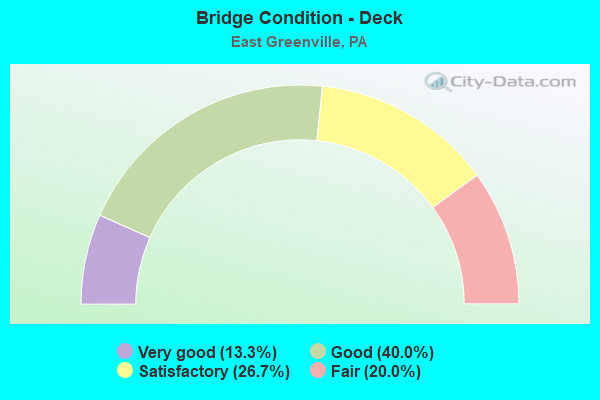
- Bridge Condition - Deck
- 13.3%Very good
- 40.0%Good
- 26.7%Satisfactory
- 20.0%Fair
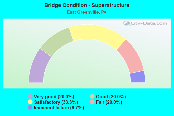
- Bridge Condition - Superstructure
- 20.0%Very good
- 20.0%Good
- 33.3%Satisfactory
- 20.0%Fair
- 6.7%Imminent failure
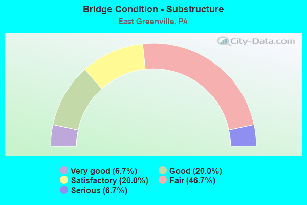
- Bridge Condition - Substructure
- 6.7%Very good
- 20.0%Good
- 20.0%Satisfactory
- 46.7%Fair
- 6.7%Serious
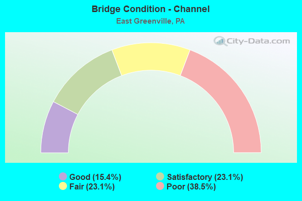
- Bridge Condition - Channel
- 15.4%Good
- 23.1%Satisfactory
- 23.1%Fair
- 38.5%Poor
Find on map >> Show street view
Structure Number: 5591, Location: .5 MI.N.OF DUNCANSVILLE (Lat: 40.437231, Lng: -78.427356), Route carried "on" structure: Interstate 99, Year Built: 1983, Year Reconstructed: 2013, Status: Open, Structure Length: 4.79m (15.72ft), Average Daily Traffic: 18,259 (year 2021), Truck Traffic: 12%, Average Future Daily Traffic: 18,398 (year 2032), Design Load: HS 20, Features Intersected: SR 8004 (22 EB TO 99 NB)
Minimum Vertical Clearance: 30+ m (98+ ft), Kilometerpoint: 21.042, Lanes on structure: 2, Lanes under structure: 1, Base Highway Network: Yes, Owner: State Highway Agency, Approaching Roadway Width: 11.6m (38.1ft), Skew: 10 degrees, Material/Design: Prestressed concrete, Design/Construction: Stringer/Multi-beam, Number Of Spans In Main Unit: 3, Length of Maximum Span: 24.4m (80.1ft), Curb or Sidewalk Widths: Left: 0.2m (0.7ft), Right: 0.2m (0.7ft), Curb-To-Curb Width: 12.8m (42.0ft), Out-to-Out Width: 13.9m (45.6ft)
Condition: Deck: Good, Superstructure: Satisfactory, Substructure: Satisfactory, Operating Rating: 68.9 metric tons, Method Used To Determine Operating Rating: Load Factor (LF), Inventory Rating: 32.7 metric tons, Method Used To Determine Inventory Rating: Load Factor (LF), Structural Evaluation: Equal to present minimum criteria, Deck Geometry: Equal to present desirable criteria, Underclear: High priority of corrective action, Approach Roadway Alignment: Equal to present desirable criteria, Length Of Structure Improvement: 5.60m (18.37ft), Designated Inspection Frequency: Every 24 months, Inspection Date: August 2020, Deck Structure Type: Concrete Cast-file-Place, Wearing Surface/Protective System: Wearing Surface: Epoxy Overlay, Deck Protection: Epoxy Coated Reinforcing
Find on map >> Show street view
Structure Number: 5606, Location: 1 MI EAST OF PINECROFT (Lat: 40.562417, Lng: -78.328403), Route carried "on" structure: Interstate 99, Year Built: 1994, Status: Open, Structure Length: 3.32m (10.89ft), Average Daily Traffic: 10,755 (year 2021), Truck Traffic: 19%, Average Future Daily Traffic: 14,998 (year 2032), Design Load: HS 25 or greater, Features Intersected: PA 764 @ EXIT 39
Minimum Vertical Clearance: 30+ m (98+ ft), Kilometerpoint: 38.788, Lanes on structure: 2, Lanes under structure: 3, Base Highway Network: Yes, Owner: State Highway Agency, Approaching Roadway Width: 12.2m (40.0ft), Skew: 10 degrees, Material/Design: Prestressed concrete, Design/Construction: Stringer/Multi-beam, Number Of Spans In Main Unit: 1, Length of Maximum Span: 32.3m (106.0ft), Curb or Sidewalk Widths: Left: 0.2m (0.7ft), Right: 0.2m (0.7ft), Curb-To-Curb Width: 12.2m (40.0ft), Out-to-Out Width: 13.3m (43.6ft)
Condition: Deck: Good, Superstructure: Good, Substructure: Good, Operating Rating: 96.2 metric tons, Method Used To Determine Operating Rating: Load Factor (LF), Inventory Rating: 48.1 metric tons, Method Used To Determine Inventory Rating: Load Factor (LF), Structural Evaluation: Better than present minimum criteria, Deck Geometry: Better than present minimum criteria, Underclear: Equal to present desirable criteria, Approach Roadway Alignment: Equal to present desirable criteria, Length Of Structure Improvement: 4.10m (13.45ft), Designated Inspection Frequency: Every 48 months, Inspection Date: March 2021, Deck Structure Type: Concrete Cast-file-Place, Wearing Surface/Protective System: Wearing Surface: Epoxy Overlay, Deck Protection: Epoxy Coated Reinforcing
Find on map >> Show street view
Structure Number: 1328, Location: RANDOLPH TOWNSHIP (Lat: 41.664694, Lng: -79.965117), Route carried "on" structure: State highway , Year Built: 1904, Year Reconstructed: 1990, Status: Open, Structure Length: 1.34m (4.40ft), Average Daily Traffic: 60 (year 2021), Truck Traffic: 13%, Average Future Daily Traffic: 85 (year 2032), Design Load: HS 25 or greater, Features Intersected: OVER WOODCOCK CREEK, Facility Carried by Structure: SR 2036,HCKRY.CRNR
Minimum Vertical Clearance: 30+ m (98+ ft), Kilometerpoint: 0.000, Lanes on structure: 2, Owner: State Highway Agency, Approaching Roadway Width: 5.8m (19.0ft), Material/Design: Steel, Design/Construction: Stringer/Multi-beam, Number Of Spans In Main Unit: 1, Length of Maximum Span: 12.8m (42.0ft), Curb-To-Curb Width: 7.3m (24.0ft), Out-to-Out Width: 7.9m (25.9ft)
Condition: Deck: Good, Superstructure: Satisfactory, Substructure: Satisfactory, Channel: Good, Operating Rating: 81.6 metric tons, Method Used To Determine Operating Rating: Load Factor (LF), Inventory Rating: 49.0 metric tons, Method Used To Determine Inventory Rating: Load Factor (LF), Structural Evaluation: Equal to present minimum criteria, Deck Geometry: Equal to present minimum criteria, Waterway Adequacy: Equal to present desirable criteria, Approach Roadway Alignment: Equal to present minimum criteria, Length Of Structure Improvement: 2.00m (6.56ft), Designated Inspection Frequency: Every 24 months, Inspection Date: July 2020, Deck Structure Type: Wood or Timber, Wearing Surface/Protective System: Wearing Surface: Bituminous
Find on map >> Show street view
Structure Number: 13651, Location: 0.5 MI.N. OF EXIT #11 (Lat: 40.138017, Lng: -77.333214), Route carried "on" structure: Interstate 81, Year Built: 1963, Status: Open, Structure Length: 1.01m (3.31ft), Average Daily Traffic: 34,704 (year 2020), Truck Traffic: 26%, Average Future Daily Traffic: 28,129 (year 2032), Design Load: HS 20, Features Intersected: T-432; KUTZ RD
Minimum Vertical Clearance: 30+ m (98+ ft), Kilometerpoint: 19.655, Lanes on structure: 2, Lanes under structure: 2, Base Highway Network: Yes, Owner: State Highway Agency, Approaching Roadway Width: 12.2m (40.0ft), Skew: 11 degrees, Material/Design: Prestressed concrete, Design/Construction: Box Beam or Girders - Single/Spread, Number Of Spans In Main Unit: 1, Length of Maximum Span: 9.4m (30.8ft), Curb or Sidewalk Widths: Left: 0.2m (0.7ft), Right: 0.2m (0.7ft), Curb-To-Curb Width: 12.3m (40.4ft), Out-to-Out Width: 13.9m (45.6ft)
Condition: Deck: Good, Superstructure: Fair, Substructure: Fair, Operating Rating: 80.7 metric tons, Method Used To Determine Operating Rating: Load Factor (LF), Inventory Rating: 42.6 metric tons, Method Used To Determine Inventory Rating: Load Factor (LF), Structural Evaluation: Somewhat better than minimum adequacy, Deck Geometry: Better than present minimum criteria, Underclear: Equal to present minimum criteria, Approach Roadway Alignment: Equal to present desirable criteria, Length Of Structure Improvement: 1.60m (5.25ft), Designated Inspection Frequency: Every 24 months, Inspection Date: November 2019, Bridge Improvement Cost: $5,000, Roadway Improvement Cost: $16,000, Total Project Cost: $72,000, Deck Structure Type: Concrete Cast-file-Place, Wearing Surface/Protective System: Wearing Surface: Bituminous
Find on map >> Show street view
Structure Number: 27572, Location: UPPER HANOVER TWP. 02J07 (Lat: 40.409553, Lng: -75.489758), Route carried "on" structure: State highway , Year Built: 1926, Year Reconstructed: 1960, Status: Open, Structure Length: 1.71m (5.61ft), Average Daily Traffic: 1,339 (year 2022), Truck Traffic: 9%, Average Future Daily Traffic: 1,385 (year 2032), Design Load: H 15, Features Intersected: BRANCH MACOBY CR/2805B5, Facility Carried by Structure: QUAKERTOWN ROAD
Minimum Vertical Clearance: 30+ m (98+ ft), Kilometerpoint: 0.779, Lanes on structure: 2, Owner: State Highway Agency, Approaching Roadway Width: 7.3m (24.0ft), Skew: 3 degrees, Material/Design: Concrete, Design/Construction: Tee Beam, Number Of Spans In Main Unit: 2, Length of Maximum Span: 8.2m (26.9ft), Curb or Sidewalk Widths: Left: 0.2m (0.7ft), Right: 1.6m (5.2ft), Curb-To-Curb Width: 6.1m (20.0ft), Out-to-Out Width: 8.8m (28.9ft)
Condition: Deck: Satisfactory, Superstructure: Satisfactory, Substructure: Fair, Channel: Poor, Operating Rating: 75.3 metric tons, Method Used To Determine Operating Rating: Field evaluation and documented engineering judgment, Inventory Rating: 37.2 metric tons, Method Used To Determine Inventory Rating: Field evaluation and documented engineering judgment, Structural Evaluation: Somewhat better than minimum adequacy, Deck Geometry: High priority of replacement, Waterway Adequacy: Better than present minimum criteria, Approach Roadway Alignment: Equal to present desirable criteria, Length Of Structure Improvement: 2.30m (7.55ft), Designated Inspection Frequency: Every 24 months, Inspection Date: November 2020, Bridge Improvement Cost: $54,000, Roadway Improvement Cost: $159,000, Total Project Cost: $729,000, Deck Structure Type: Concrete Cast-file-Place, Wearing Surface/Protective System: Wearing Surface: Bituminous, Membrane: Preformed Fabric
Find on map >> Show street view
Structure Number: 27576, Location: UPPER HANOVER TWP. 02E10 (Lat: 40.393772, Lng: -75.515461), Route carried "on" structure: State highway , Year Built: 1933, Status: Open, Structure Length: 3.84m (12.60ft), Average Daily Traffic: 1,669 (year 2021), Truck Traffic: 9%, Average Future Daily Traffic: 2,091 (year 2032), Design Load: H 15, Features Intersected: PERKIOMEN CREEK 2804H07, Facility Carried by Structure: CHURCH ROAD
Minimum Vertical Clearance: 30+ m (98+ ft), Kilometerpoint: 0.005, Lanes on structure: 2, Owner: State Highway Agency, Approaching Roadway Width: 7.3m (24.0ft), Material/Design: Steel, Design/Construction: Stringer/Multi-beam, Number Of Spans In Main Unit: 3, Length of Maximum Span: 12.5m (41.0ft), Curb or Sidewalk Widths: Left: 1.2m (3.9ft), Right: 0.3m (1.0ft), Curb-To-Curb Width: 7.4m (24.3ft), Out-to-Out Width: 9.1m (29.9ft)
Condition: Deck: Fair, Superstructure: Fair, Substructure: Fair, Channel: Poor, Operating Rating: 69.9 metric tons, Method Used To Determine Operating Rating: Load Factor (LF), Inventory Rating: 41.7 metric tons, Method Used To Determine Inventory Rating: Load Factor (LF), Structural Evaluation: Somewhat better than minimum adequacy, Deck Geometry: Meets minimum limits, Waterway Adequacy: Better than present minimum criteria, Approach Roadway Alignment: Equal to present desirable criteria, Length Of Structure Improvement: 4.80m (15.75ft), Designated Inspection Frequency: Every 24 months, Inspection Date: July 2021, Bridge Improvement Cost: $118,000, Roadway Improvement Cost: $347,000, Total Project Cost: $1,591,000, Deck Structure Type: Concrete Cast-file-Place, Wearing Surface/Protective System: Wearing Surface: Bituminous
Find on map >> Show street view
Structure Number: 27582, Location: NE CORNER 2A11/2804C9 (Lat: 40.384422, Lng: -75.544422), Route carried "on" structure: State highway , Year Built: 1935, Year Reconstructed: 1993, Status: Open, Structure Length: 2.65m (8.69ft), Average Daily Traffic: 765 (year 2022), Truck Traffic: 9%, Average Future Daily Traffic: 1,202 (year 2032), Design Load: HS 25 or greater, Features Intersected: W. BR. PERKIOMEN CREEK, Facility Carried by Structure: WEST BRANCH ROAD
Minimum Vertical Clearance: 30+ m (98+ ft), Kilometerpoint: 0.000, Lanes on structure: 2, Owner: State Highway Agency, Approaching Roadway Width: 9.1m (29.9ft), Material/Design: Prestressed concrete, Design/Construction: Box Beam or Girders - Single/Spread, Number Of Spans In Main Unit: 2, Length of Maximum Span: 12.8m (42.0ft), Curb or Sidewalk Widths: Left: 0.2m (0.7ft), Right: 0.2m (0.7ft), Curb-To-Curb Width: 9.1m (29.9ft), Out-to-Out Width: 10.2m (33.5ft)
Condition: Deck: Satisfactory, Superstructure: Very good, Substructure: Satisfactory, Channel: Fair, Operating Rating: 83.5 metric tons, Method Used To Determine Operating Rating: Load Factor (LF), Inventory Rating: 44.5 metric tons, Method Used To Determine Inventory Rating: Load Factor (LF), Structural Evaluation: Equal to present minimum criteria, Deck Geometry: Equal to present minimum criteria, Waterway Adequacy: Equal to present desirable criteria, Approach Roadway Alignment: Somewhat better than minimum adequacy, Length Of Structure Improvement: 3.30m (10.83ft), Designated Inspection Frequency: Every 24 months, Inspection Date: August 2021, Deck Structure Type: Concrete Cast-file-Place, Wearing Surface/Protective System: Wearing Surface: Monolithic Concrete, Deck Protection: Epoxy Coated Reinforcing
Find on map >> Show street view
Structure Number: 27927, Location: .5 Mi S PA-29 ADC 2804-G4 (Lat: 40.414578, Lng: -75.523689), Route carried "on" structure: City street , Year Built: 1880, Year Reconstructed: 1987, Status: Posted for load, Structure Length: 3.14m (10.30ft), Average Daily Traffic: 784 (year 2019), Average Future Daily Traffic: 1,052 (year 2018), Features Intersected: PERKIOMEN CREEK, Facility Carried by Structure: PEEVY ROAD
Minimum Vertical Clearance: 3.87m (12.70ft), Kilometerpoint: 0.000, Lanes on structure: 1, Owner: County Highway Agency, Approaching Roadway Width: 5.5m (18.0ft), Material/Design: Steel, Design/Construction: Truss - Thru, Number Of Spans In Main Unit: 1, Length of Maximum Span: 30.5m (100.1ft), Curb-To-Curb Width: 3.7m (12.1ft), Out-to-Out Width: 4.9m (16.1ft)
Condition: Deck: Very good, Superstructure: Very good, Substructure: Fair, Channel: Fair, Operating Rating: 32.7 metric tons, Method Used To Determine Operating Rating: Allowable Stress (AS), Inventory Rating: 21.8 metric tons, Method Used To Determine Inventory Rating: Allowable Stress (AS), Structural Evaluation: Somewhat better than minimum adequacy, Deck Geometry: High priority of replacement, Waterway Adequacy: Equal to present desirable criteria, Approach Roadway Alignment: Better than present minimum criteria, Bridge Posting: Required (Relationship of Operating Rating to Maximum Legal Load: 20.0 - 29.9% below), Length Of Structure Improvement: 3.80m (12.47ft), Designated Inspection Frequency: Every 24 months, Critical Feature Inspection Frequency: Every 12 months, Other Special Inspection Frequency: Every 12 months, Inspection Date: October 2020, Critical Feature Inspection Date: October 2020, Other Special Inspection Date: October 2020, Bridge Improvement Cost: $49,000, Roadway Improvement Cost: $144,000, Total Project Cost: $662,000, Deck Structure Type: Other, Wearing Surface/Protective System: Wearing Surface: Other, Membrane: Epoxy, Deck Protection: Other
Find on map >> Show street view
Structure Number: 27928, Location: 0.85 MI SW OF SR 29 02D07 (Lat: 40.407706, Lng: -75.522261), Route carried "on" structure: City street , Year Built: 1905, Year Reconstructed: 1999, Status: Closed, Structure Length: 13.75m (45.11ft), Average Daily Traffic: 250 (year 1977), Average Future Daily Traffic: 2,000 (year 2015), Features Intersected: PERKIOMEN CREEK, Facility Carried by Structure: FRUITVILLE ROAD
Minimum Vertical Clearance: 3.45m (11.32ft), Kilometerpoint: 0.000, Lanes on structure: 1, Owner: County Highway Agency, Approaching Roadway Width: 5.5m (18.0ft), Material/Design: Steel, Design/Construction: Truss - Thru, Number Of Spans In Main Unit: 1, Number Of Approach Spans: 6, Length of Maximum Span: 31.1m (102.0ft), Curb-To-Curb Width: 4.6m (15.1ft), Out-to-Out Width: 4.9m (16.1ft)
Condition: Deck: Satisfactory, Superstructure: Imminent failure, Substructure: Serious, Channel: Poor, Waterway Adequacy: Equal to present desirable criteria, Approach Roadway Alignment: Meets minimum limits, Bridge Posting: Required (Relationship of Operating Rating to Maximum Legal Load: > 39.9% below), Length Of Structure Improvement: 13.70m (44.95ft), Designated Inspection Frequency: Every 24 months, Critical Feature Inspection Frequency: Every 24 months, Underwater Inspection Frequency: Every 24 months, Inspection Date: July 2020, Critical Feature Inspection Date: July 2018, Underwater Inspection Date: June 2020, Bridge Improvement Cost: $84,000, Roadway Improvement Cost: $248,000, Total Project Cost: $1,136,000, Deck Structure Type: Wood or Timber, Wearing Surface/Protective System: Wearing Surface: Wood or Timber
Find on map >> Show street view
Structure Number: 28101, Location: T207/MACOBY CREEK 2804-K3 (Lat: 40.419269, Lng: -75.504378), Route carried "on" structure: City street , Year Built: 1928, Status: Open, Structure Length: 0.73m (2.40ft), Average Daily Traffic: 600 (year 2015), Truck Traffic: 5%, Average Future Daily Traffic: 678 (year 2035), Features Intersected: MACOBY CREEK, Facility Carried by Structure: KRAUSSDALE ROAD
Minimum Vertical Clearance: 30+ m (98+ ft), Kilometerpoint: 0.000, Lanes on structure: 2, Owner: Town or Township Highway Agency, Approaching Roadway Width: 7.0m (23.0ft), Skew: 1 degrees, Material/Design: Concrete, Design/Construction: Slab, Number Of Spans In Main Unit: 1, Length of Maximum Span: 6.7m (22.0ft), Curb-To-Curb Width: 6.7m (22.0ft), Out-to-Out Width: 7.9m (25.9ft)
Condition: Deck: Satisfactory, Superstructure: Satisfactory, Substructure: Fair, Channel: Poor, Operating Rating: 78.9 metric tons, Method Used To Determine Operating Rating: Field evaluation and documented engineering judgment, Inventory Rating: 47.2 metric tons, Method Used To Determine Inventory Rating: Field evaluation and documented engineering judgment, Structural Evaluation: Somewhat better than minimum adequacy, Deck Geometry: Meets minimum limits, Waterway Adequacy: Equal to present minimum criteria, Approach Roadway Alignment: Equal to present desirable criteria, Length Of Structure Improvement: 0.90m (2.95ft), Designated Inspection Frequency: Every 24 months, Inspection Date: June 2021, Deck Structure Type: Concrete Cast-file-Place, Wearing Surface/Protective System: Wearing Surface: Bituminous
Find on map >> Show street view
Structure Number: 28102, Location: 1.2 Mi N of RT663 2805-B3 (Lat: 40.419619, Lng: -75.491294), Route carried "on" structure: City street , Year Built: 1937, Status: Open, Structure Length: 0.70m (2.30ft), Average Daily Traffic: 150 (year 2017), Truck Traffic: 3%, Average Future Daily Traffic: 400 (year 2037), Design Load: HS 20, Features Intersected: TRIB.OF MACOBY CREEK, Facility Carried by Structure: WASSER ROAD
Minimum Vertical Clearance: 30+ m (98+ ft), Kilometerpoint: 0.000, Lanes on structure: 2, Owner: Town or Township Highway Agency, Approaching Roadway Width: 6.1m (20.0ft), Material/Design: Concrete, Design/Construction: Slab, Number Of Spans In Main Unit: 1, Length of Maximum Span: 6.7m (22.0ft), Curb-To-Curb Width: 6.2m (20.3ft), Out-to-Out Width: 7.0m (23.0ft)
Condition: Deck: Fair, Superstructure: Fair, Substructure: Fair, Channel: Fair, Operating Rating: 68.9 metric tons, Method Used To Determine Operating Rating: Load Factor (LF), Inventory Rating: 40.8 metric tons, Method Used To Determine Inventory Rating: Load Factor (LF), Structural Evaluation: Somewhat better than minimum adequacy, Deck Geometry: Meets minimum limits, Waterway Adequacy: Equal to present desirable criteria, Approach Roadway Alignment: Better than present minimum criteria, Length Of Structure Improvement: 0.90m (2.95ft), Designated Inspection Frequency: Every 24 months, Inspection Date: July 2019, Bridge Improvement Cost: $5,000, Roadway Improvement Cost: $36,000, Total Project Cost: $70,000, Deck Structure Type: Concrete Cast-file-Place, Wearing Surface/Protective System: Wearing Surface: Bituminous
Find on map >> Show street view
Structure Number: 28104, Location: T211/MACOBY CREEK 2805-B4 (Lat: 40.414036, Lng: -75.490169), Route carried "on" structure: City street , Year Built: 1936, Status: Open, Structure Length: 0.70m (2.30ft), Average Daily Traffic: 150 (year 1989), Truck Traffic: 1%, Average Future Daily Traffic: 200 (year 2009), Features Intersected: BRANCH MACOBY CREEK, Facility Carried by Structure: BAUS ROAD
Minimum Vertical Clearance: 30+ m (98+ ft), Kilometerpoint: 0.000, Lanes on structure: 2, Owner: Town or Township Highway Agency, Approaching Roadway Width: 5.8m (19.0ft), Material/Design: Concrete, Design/Construction: Slab, Number Of Spans In Main Unit: 1, Length of Maximum Span: 6.7m (22.0ft), Curb-To-Curb Width: 6.1m (20.0ft), Out-to-Out Width: 7.0m (23.0ft)
Condition: Deck: Fair, Superstructure: Satisfactory, Substructure: Fair, Channel: Poor, Operating Rating: 78.0 metric tons, Method Used To Determine Operating Rating: Field evaluation and documented engineering judgment, Inventory Rating: 46.3 metric tons, Method Used To Determine Inventory Rating: Field evaluation and documented engineering judgment, Structural Evaluation: Somewhat better than minimum adequacy, Deck Geometry: Meets minimum limits, Waterway Adequacy: Equal to present desirable criteria, Approach Roadway Alignment: Equal to present desirable criteria, Length Of Structure Improvement: 0.90m (2.95ft), Designated Inspection Frequency: Every 24 months, Inspection Date: June 2021, Bridge Improvement Cost: $8,000, Roadway Improvement Cost: $61,000, Total Project Cost: $111,000, Wearing Surface/Protective System: Wearing Surface: Bituminous
Find on map >> Show street view
Structure Number: 28105, Location: 1.2 Mi W PA-663 2804-E10 (Lat: 40.377200, Lng: -75.534597), Route carried "on" structure: City street , Year Built: 2001, Status: Open, Structure Length: 2.53m (8.30ft), Average Daily Traffic: 500 (year 2015), Truck Traffic: 1%, Average Future Daily Traffic: 750 (year 2035), Design Load: HS 25 or greater, Features Intersected: WEST BRANCH PERKIOMEN CR, Facility Carried by Structure: BOWERS MILL ROAD
Minimum Vertical Clearance: 30+ m (98+ ft), Kilometerpoint: 0.000, Lanes on structure: 2, Owner: Town or Township Highway Agency, Approaching Roadway Width: 7.3m (24.0ft), Material/Design: Prestressed concrete, Design/Construction: Box Beam or Girders - Single/Spread, Number Of Spans In Main Unit: 1, Length of Maximum Span: 24.7m (81.0ft), Curb or Sidewalk Widths: Left: 0.2m (0.7ft), Right: 0.2m (0.7ft), Curb-To-Curb Width: 7.3m (24.0ft), Out-to-Out Width: 8.2m (26.9ft)
Condition: Deck: Good, Superstructure: Good, Substructure: Good, Channel: Satisfactory, Inventory Rating: 60.8 metric tons, Method Used To Determine Inventory Rating: Load Factor (LF), Structural Evaluation: Better than present minimum criteria, Deck Geometry: Meets minimum limits, Waterway Adequacy: Better than present minimum criteria, Approach Roadway Alignment: Equal to present minimum criteria, Length Of Structure Improvement: 3.20m (10.50ft), Designated Inspection Frequency: Every 24 months, Inspection Date: September 2020, Deck Structure Type: Concrete Cast-file-Place, Wearing Surface/Protective System: Wearing Surface: Monolithic Concrete, Deck Protection: Epoxy Coated Reinforcing
Find on map >> Show street view
Structure Number: 45567, Location: W- PENNSBURG 2B10/2804E8 (Lat: 40.392608, Lng: -75.533661), Route carried "on" structure: State highway , Year Built: 2009, Status: Open, Structure Length: 0.76m (2.49ft), Average Daily Traffic: 1,838 (year 2022), Truck Traffic: 6%, Average Future Daily Traffic: 1,860 (year 2032), Design Load: HL 93, Features Intersected: MOLASSES CREEK, Facility Carried by Structure: KUTZTOWN ROAD
Minimum Vertical Clearance: 30+ m (98+ ft), Kilometerpoint: 2.234, Lanes on structure: 2, Base Highway Network: Yes, Owner: State Highway Agency, Approaching Roadway Width: 8.2m (26.9ft), Skew: 1 degrees, Material/Design: Concrete, Design/Construction: Frame, Number Of Spans In Main Unit: 1, Length of Maximum Span: 7.0m (23.0ft), Curb-To-Curb Width: 8.1m (26.6ft), Out-to-Out Width: 9.0m (29.5ft)
Condition: Deck: Good, Superstructure: Good, Substructure: Good, Channel: Satisfactory, Operating Rating: 62.6 metric tons, Method Used To Determine Operating Rating: Assigned ratings based on Load and Resistance Factor Design (LRFD) reported in metric tons, Inventory Rating: 48.1 metric tons, Method Used To Determine Inventory Rating: Assigned ratings based on Load and Resistance Factor Design (LRFD) reported in metric tons, Structural Evaluation: Better than present minimum criteria, Deck Geometry: Meets minimum limits, Waterway Adequacy: Equal to present minimum criteria, Approach Roadway Alignment: Equal to present desirable criteria, Designated Inspection Frequency: Every 24 months, Inspection Date: December 2019, Deck Structure Type: Concrete Cast-file-Place, Wearing Surface/Protective System: Wearing Surface: Monolithic Concrete, Deck Protection: Epoxy Coated Reinforcing
Find on map >> Show street view
Structure Number: 48487, Location: 1 MI. E. BERKS 2804F03 (Lat: 40.424603, Lng: -75.526517), Route carried "on" structure: State highway 29, Year Built: 2014, Status: Open, Structure Length: 2.01m (6.59ft), Average Daily Traffic: 7,609 (year 2020), Truck Traffic: 14%, Average Future Daily Traffic: 13,122 (year 2032), Design Load: HL 93, Features Intersected: HOSENSACK CREEK, Facility Carried by Structure: GRAVEL PIKE
Minimum Vertical Clearance: 30+ m (98+ ft), Kilometerpoint: 38.143, Lanes on structure: 2, Base Highway Network: Yes, Owner: State Highway Agency, Approaching Roadway Width: 12.2m (40.0ft), Skew: 1 degrees, Material/Design: Prestressed concrete, Design/Construction: Box Beam or Girders - Single/Spread, Number Of Spans In Main Unit: 1, Length of Maximum Span: 19.5m (64.0ft), Curb or Sidewalk Widths: Left: 0.1m (0.3ft), Right: 0.1m (0.3ft), Curb-To-Curb Width: 12.2m (40.0ft), Out-to-Out Width: 13.4m (44.0ft)
Condition: Deck: Very good, Superstructure: Very good, Substructure: Very good, Channel: Good, Operating Rating: 61.6 metric tons, Method Used To Determine Operating Rating: Assigned ratings based on Load and Resistance Factor Design (LRFD) reported by rating factor (RF) using HL93 loadings, Inventory Rating: 35.6 metric tons, Method Used To Determine Inventory Rating: Assigned ratings based on Load and Resistance Factor Design (LRFD) reported by rating factor (RF) using HL93 loadings, Structural Evaluation: Equal to present desirable criteria, Deck Geometry: Somewhat better than minimum adequacy, Waterway Adequacy: Equal to present desirable criteria, Approach Roadway Alignment: Equal to present desirable criteria, Designated Inspection Frequency: Every 24 months, Inspection Date: December 2020, Deck Structure Type: Concrete Cast-file-Place, Wearing Surface/Protective System: Wearing Surface: Monolithic Concrete, Membrane: Other, Deck Protection: Epoxy Coated Reinforcing
Find on map >> Show street view
Structure Number: 68125, Location: 0.3 MI.E OF SR29 2805-A5 (Lat: 40.409200, Lng: -75.497483), Route carried "on" structure: City street , Year Built: 2021, Status: Open, Structure Length: 0.79m (2.59ft), Average Daily Traffic: 500 (year 2021), Truck Traffic: 2%, Average Future Daily Traffic: 550 (year 2041), Design Load: HL 93, Features Intersected: MACOBY CREEK, Facility Carried by Structure: TAGART ROAD
Minimum Vertical Clearance: 30+ m (98+ ft), Kilometerpoint: 0.000, Lanes on structure: 2, Owner: Town or Township Highway Agency, Approaching Roadway Width: 7.9m (25.9ft), Material/Design: Concrete, Design/Construction: Culvert, Number Of Spans In Main Unit: 1, Length of Maximum Span: 7.9m (25.9ft), Out-to-Out Width: 12.2m (40.0ft)
Condition: Channel: Satisfactory, Culverts: Very good, Operating Rating: 48.6 metric tons, Method Used To Determine Operating Rating: Assigned ratings based on Load and Resistance Factor Design (LRFD) reported by rating factor (RF) using HL93 loadings, Inventory Rating: 35.6 metric tons, Method Used To Determine Inventory Rating: Assigned ratings based on Load and Resistance Factor Design (LRFD) reported by rating factor (RF) using HL93 loadings, Structural Evaluation: Equal to present desirable criteria, Waterway Adequacy: Equal to present desirable criteria, Approach Roadway Alignment: Equal to present desirable criteria, Designated Inspection Frequency: Every 24 months, Inspection Date: April 2021