Bridge Statistics for Eastlake, Michigan (MI)
Condition, Traffic, Stress, Structural Evaluation, Project Costs
- National Bridge Inventory (NBI) Statistics
- 20Number of bridges
- 121ft / 37mTotal length
- $891,000Total costs
- 54,658Total average daily traffic
- 10,199Total average daily truck traffic
- 70,967Total future (year 2013) average daily traffic
- National Bridge Inventory (NBI) Registered Bridges for Eastlake
- No street view available for this location
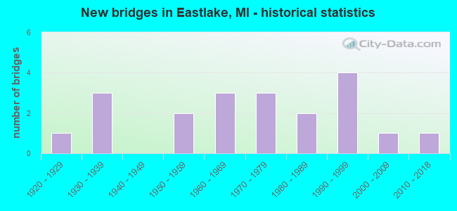
- New bridges - historical statistics
- 11920-1929
- 31930-1939
- 21950-1959
- 31960-1969
- 31970-1979
- 21980-1989
- 41990-1999
- 12000-2009
- 12010-2018
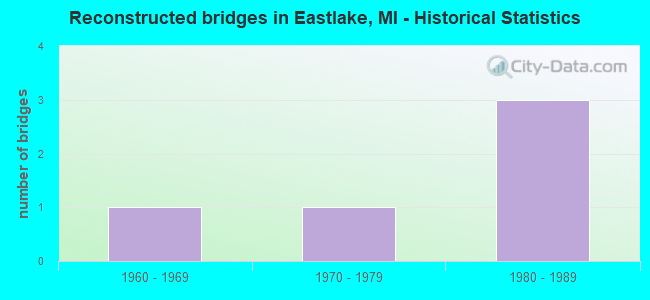
- Reconstructed bridges - Historical Statistics
- 11960-1969
- 11970-1979
- 31980-1989
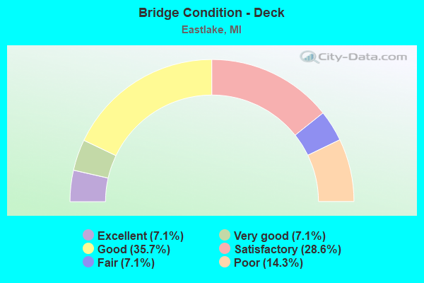
- Bridge Condition - Deck
- 7.1%Excellent
- 7.1%Very good
- 35.7%Good
- 28.6%Satisfactory
- 7.1%Fair
- 14.3%Poor
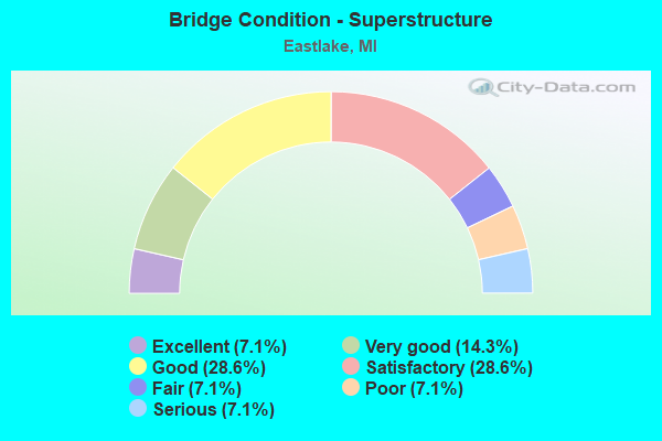
- Bridge Condition - Superstructure
- 7.1%Excellent
- 14.3%Very good
- 28.6%Good
- 28.6%Satisfactory
- 7.1%Fair
- 7.1%Poor
- 7.1%Serious
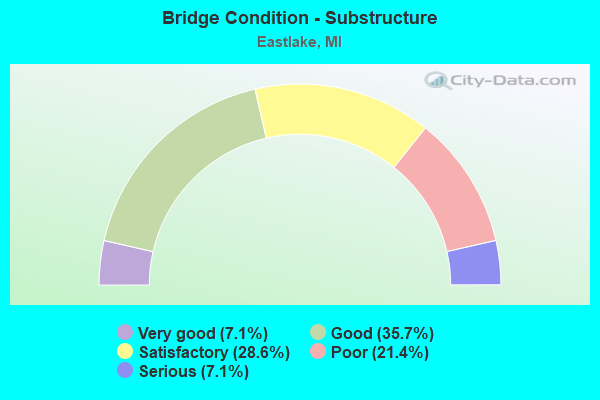
- Bridge Condition - Substructure
- 7.1%Very good
- 35.7%Good
- 28.6%Satisfactory
- 21.4%Poor
- 7.1%Serious
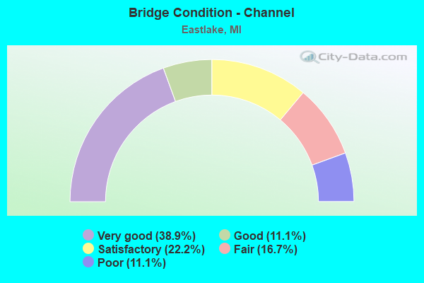
- Bridge Condition - Channel
- 38.9%Very good
- 11.1%Good
- 22.2%Satisfactory
- 16.7%Fair
- 11.1%Poor
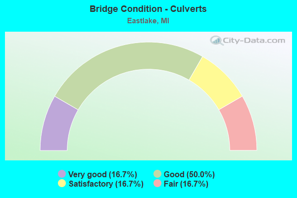
- Bridge Condition - Culverts
- 16.7%Very good
- 50.0%Good
- 16.7%Satisfactory
- 16.7%Fair
Find on map >> Show street view
Structure Number: 329, Location: 1.0 MI E OF M-65 (Lat: 45.067339, Lng: -83.696792), Route carried "on" structure: State highway 32, Year Built: 1934, Year Reconstructed: 1965, Status: Open, Structure Length: 1.09m (3.58ft), Average Daily Traffic: 5,505 (year 2007), Truck Traffic: 9%, Average Future Daily Traffic: 7,645 (year 2018), Design Load: H 15, Features Intersected: BEAN CREEK
Minimum Vertical Clearance: 30.48m (100.00ft), Kilometerpoint: 14.639, Lanes on structure: 2, Base Highway Network: Yes (Inventory Route: 102, Subroute: 9), Owner: State Highway Agency, Approaching Roadway Width: 128.0m (419.9ft), Material/Design: Steel, Design/Construction: Stringer/Multi-beam, Number Of Spans In Main Unit: 1, Length of Maximum Span: 10.9m (35.8ft), Curb-To-Curb Width: 13.7m (44.9ft), Out-to-Out Width: 14.4m (47.2ft)
Condition: Deck: Satisfactory, Superstructure: Satisfactory, Substructure: Satisfactory, Channel: Very good, Operating Rating: 45.4 metric tons, Method Used To Determine Operating Rating: Load Factor (LF) rating reported by rating factor (RF) method using MS18 loading, Inventory Rating: 27.2 metric tons, Method Used To Determine Inventory Rating: Load Factor (LF) rating reported by rating factor (RF) method using MS18 loading, Structural Evaluation: Equal to present minimum criteria, Deck Geometry: Superior to present desirable criteria, Waterway Adequacy: Better than present minimum criteria, Approach Roadway Alignment: Equal to present desirable criteria, Designated Inspection Frequency: Every 24 months, Inspection Date: July 2016, Deck Structure Type: Concrete Cast-file-Place, Wearing Surface/Protective System: Wearing Surface: Bituminous
Find on map >> Show street view
Structure Number: 709, Location: 600 FT S WHITEFEATHER RD (Lat: 43.894992, Lng: -83.985894), Route carried "on" structure: County highway , Year Built: 1937, Status: Posted for load, Structure Length: 0.73m (2.40ft), Average Daily Traffic: 274 (year 2000), Truck Traffic: 2%, Average Future Daily Traffic: 438 (year 2020), Design Load: H 15, Features Intersected: WHITEFEATHER DRAIN, Facility Carried by Structure: MACKINAW RD
Minimum Vertical Clearance: 30.48m (100.00ft), Kilometerpoint: 41.333, Lanes on structure: 2, Owner: County Highway Agency, Approaching Roadway Width: 98.0m (321.5ft), Material/Design: Steel, Design/Construction: Stringer/Multi-beam, Number Of Spans In Main Unit: 1, Length of Maximum Span: 6.1m (20.0ft), Curb-To-Curb Width: 8.2m (26.9ft), Out-to-Out Width: 9.2m (30.2ft)
Condition: Deck: Poor, Superstructure: Serious, Substructure: Serious, Channel: Fair, Operating Rating: 2.6 metric tons, Method Used To Determine Operating Rating: Load Factor (LF), Inventory Rating: 15.6 metric tons, Method Used To Determine Inventory Rating: Load Factor (LF), Structural Evaluation: High priority of corrective action, Deck Geometry: Somewhat better than minimum adequacy, Waterway Adequacy: Equal to present minimum criteria, Approach Roadway Alignment: Equal to present desirable criteria, Bridge Posting: Required (Relationship of Operating Rating to Maximum Legal Load: > 39.9% below), Length Of Structure Improvement: 9.10m (29.86ft), Designated Inspection Frequency: Every 12 months, Inspection Date: April 2017, Bridge Improvement Cost: $137,000, Roadway Improvement Cost: $8,000, Total Project Cost: $145,000, Deck Structure Type: Concrete Cast-file-Place, Wearing Surface/Protective System: Wearing Surface: Bituminous
Find on map >> Show street view
Structure Number: 1946, Location: 0.5 MI E OF FRANCIS RD (Lat: 42.943375, Lng: -84.650036), Route carried "on" structure: County highway , Year Built: 1968, Status: Open, Structure Length: 1.03m (3.38ft), Average Daily Traffic: 183 (year 2011), Average Future Daily Traffic: 331 (year 2031), Design Load: HS 20, Features Intersected: BAD CREEK, Facility Carried by Structure: CENTER LINE ROAD
Minimum Vertical Clearance: 30.48m (100.00ft), Kilometerpoint: 4.508, Lanes on structure: 2, Owner: County Highway Agency, Approaching Roadway Width: 73.0m (239.5ft), Material/Design: Prestressed concrete, Design/Construction: Box Beam or Girders - Multiple, Number Of Spans In Main Unit: 1, Length of Maximum Span: 9.7m (31.8ft), Curb-To-Curb Width: 5.2m (17.1ft), Out-to-Out Width: 5.4m (17.7ft)
Condition: Deck: Poor, Superstructure: Poor, Substructure: Poor, Channel: Poor, Operating Rating: 59.2 metric tons, Method Used To Determine Operating Rating: Load Factor (LF), Inventory Rating: 35.5 metric tons, Method Used To Determine Inventory Rating: Load Factor (LF), Structural Evaluation: Meets minimum limits, Deck Geometry: High priority of replacement, Waterway Adequacy: Somewhat better than minimum adequacy, Approach Roadway Alignment: Equal to present desirable criteria, Length Of Structure Improvement: 13.40m (43.96ft), Designated Inspection Frequency: Every 24 months, Inspection Date: November 2017, Bridge Improvement Cost: $171,000, Roadway Improvement Cost: $40,000, Total Project Cost: $211,000, Deck Structure Type: Concrete Precast Panels
Find on map >> Show street view
Structure Number: 1947, Location: 0.3 MI W OF FOREST HILL (Lat: 42.958017, Lng: -84.689797), Route carried "on" structure: County highway , Year Built: 1920, Year Reconstructed: 1980, Status: Open, Structure Length: 1.89m (6.20ft), Average Daily Traffic: 132 (year 2011), Average Future Daily Traffic: 238 (year 2031), Design Load: HS 20, Features Intersected: STONY CREEK, Facility Carried by Structure: TAFT ROAD
Minimum Vertical Clearance: 30.48m (100.00ft), Kilometerpoint: 0.205, Lanes on structure: 2, Owner: County Highway Agency, Approaching Roadway Width: 85.0m (278.9ft), Material/Design: Prestressed concrete, Design/Construction: Box Beam or Girders - Multiple, Number Of Spans In Main Unit: 1, Length of Maximum Span: 18.2m (59.7ft), Curb-To-Curb Width: 5.5m (18.0ft), Out-to-Out Width: 5.5m (18.0ft)
Condition: Deck: Satisfactory, Superstructure: Fair, Substructure: Poor, Channel: Poor, Operating Rating: 58.1 metric tons, Method Used To Determine Operating Rating: Load Factor (LF), Inventory Rating: 34.8 metric tons, Method Used To Determine Inventory Rating: Load Factor (LF), Structural Evaluation: Meets minimum limits, Deck Geometry: High priority of corrective action, Waterway Adequacy: Superior to present desirable criteria, Approach Roadway Alignment: Meets minimum limits, Designated Inspection Frequency: Every 24 months, Inspection Date: November 2017, Bridge Improvement Cost: $268,000, Roadway Improvement Cost: $20,000, Total Project Cost: $240,000, Deck Structure Type: Concrete Precast Panels, Wearing Surface/Protective System: Wearing Surface: Bituminous
Find on map >> Show street view
Structure Number: 2152, Location: 1.5 M W 0.5 M N BRAMPTON (Lat: 45.933642, Lng: -87.102133), Route carried "on" structure: County highway , Year Built: 2015, Status: Open, Structure Length: 1.07m (3.51ft), Average Daily Traffic: 120 (year 2015), Average Future Daily Traffic: 145 (year 2035), Design Load: Greater than HL93, Features Intersected: DAYS RIVER, Facility Carried by Structure: COUNTY ROAD F 4
Minimum Vertical Clearance: 30.48m (100.00ft), Kilometerpoint: 0.431, Lanes on structure: 2, Owner: County Highway Agency, Approaching Roadway Width: 85.0m (278.9ft), Material/Design: Prestressed concrete, Design/Construction: Box Beam or Girders - Multiple, Number Of Spans In Main Unit: 1, Length of Maximum Span: 10.3m (33.8ft), Curb-To-Curb Width: 8.6m (28.2ft), Out-to-Out Width: 9.6m (31.5ft)
Condition: Deck: Excellent, Superstructure: Excellent, Substructure: Very good, Channel: Very good, Operating Rating: 91.7 metric tons, Method Used To Determine Operating Rating: Load and Resistance Factor Rating (LRFR) rating reported by rating factor(RF) method using HL-93 loadings, Inventory Rating: 70.6 metric tons, Method Used To Determine Inventory Rating: Load and Resistance Factor Rating (LRFR) rating reported by rating factor(RF) method using HL-93 loadings, Structural Evaluation: Equal to present desirable criteria, Deck Geometry: High priority of corrective action, Waterway Adequacy: Equal to present desirable criteria, Approach Roadway Alignment: Equal to present minimum criteria, Designated Inspection Frequency: Every 24 months, Inspection Date: July 2016, Deck Structure Type: Concrete Cast-file-Place, Wearing Surface/Protective System: Wearing Surface: Monolithic Concrete, Deck Protection: Epoxy Coated Reinforcing
Find on map >> Show street view
Structure Number: 2339, Location: 5 MI SW OF CHARLOTTE (Lat: 42.509692, Lng: -84.867483), Route carried "on" structure: County highway 2324, Year Built: 1958, Status: Open, Structure Length: 2.56m (8.40ft), Average Daily Traffic: 694 (year 2010), Average Future Daily Traffic: 900 (year 2013), Features Intersected: BATTLE CREEK RIVER, Facility Carried by Structure: FIVE POINT HWY
Minimum Vertical Clearance: 30.48m (100.00ft), Kilometerpoint: 16.001, Lanes on structure: 2, Owner: County Highway Agency, Approaching Roadway Width: 79.0m (259.2ft), Material/Design: Prestressed concrete, Design/Construction: Box Beam or Girders - Multiple, Number Of Spans In Main Unit: 2, Length of Maximum Span: 12.5m (41.0ft), Curb-To-Curb Width: 7.9m (25.9ft), Out-to-Out Width: 9.4m (30.8ft)
Condition: Deck: Good, Superstructure: Good, Substructure: Good, Channel: Good, Operating Rating: 52.8 metric tons, Method Used To Determine Operating Rating: Load Factor (LF) rating reported by rating factor (RF) method using MS18 loading, Inventory Rating: 31.4 metric tons, Method Used To Determine Inventory Rating: Load Factor (LF) rating reported by rating factor (RF) method using MS18 loading, Structural Evaluation: Better than present minimum criteria, Deck Geometry: Somewhat better than minimum adequacy, Waterway Adequacy: Equal to present desirable criteria, Approach Roadway Alignment: Equal to present desirable criteria, Designated Inspection Frequency: Every 24 months, Inspection Date: April 2017, Deck Structure Type: Concrete Precast Panels, Wearing Surface/Protective System: Wearing Surface: Bituminous
Find on map >> Show street view
Structure Number: 2375, Location: 2 MI NW OF POTTERVILLE (Lat: 42.662414, Lng: -84.758575), Route carried "on" structure: County highway , Year Built: 1996, Status: Open, Structure Length: 0.99m (3.25ft), Average Daily Traffic: 49 (year 2012), Average Future Daily Traffic: 90 (year 2015), Design Load: HS 20, Features Intersected: THORNAPPLE DRAIN, Facility Carried by Structure: JOHNSON ROAD
Minimum Vertical Clearance: 30.48m (100.00ft), Kilometerpoint: 0.000, Lanes on structure: 2, Owner: County Highway Agency, Approaching Roadway Width: 0.9m (3.0ft), Skew: 4 degrees, Material/Design: Aluminum, Iron, Design/Construction: Culvert, Number Of Spans In Main Unit: 1, Length of Maximum Span: 9.9m (32.5ft), Curb-To-Curb Width: 0.9m (3.0ft), Out-to-Out Width: 13.6m (44.6ft)
Condition: Channel: Very good, Culverts: Very good, Operating Rating: 6.3 metric tons, Method Used To Determine Operating Rating: Load Factor (LF), Inventory Rating: 3.6 metric tons, Method Used To Determine Inventory Rating: Load Factor (LF), Structural Evaluation: Equal to present desirable criteria, Deck Geometry: Better than present minimum criteria, Waterway Adequacy: Equal to present desirable criteria, Approach Roadway Alignment: Equal to present desirable criteria, Designated Inspection Frequency: Every 24 months, Inspection Date: May 2017
Find on map >> Show street view
Structure Number: 3605, Location: SEC 17-20 HUME TWP (Lat: 43.979594, Lng: -83.089800), Route carried "on" structure: ServiceCounty highway , Year Built: 1981, Status: Open, Structure Length: 0.66m (2.17ft), Average Daily Traffic: 12 (year 2009), Average Future Daily Traffic: 22 (year 2029), Design Load: H 20, Features Intersected: TAFT DRAIN, Facility Carried by Structure: WITHERSPOON ROAD
Minimum Vertical Clearance: 30.48m (100.00ft), Kilometerpoint: 2.649, Lanes on structure: 2, Owner: County Highway Agency, Approaching Roadway Width: 55.0m (180.4ft), Material/Design: Steel, Design/Construction: Culvert, Number Of Spans In Main Unit: 1, Length of Maximum Span: 6.6m (21.7ft)
Condition: Channel: Very good, Culverts: Good, Operating Rating: 32.4 metric tons, Method Used To Determine Operating Rating: Load Factor (LF) rating reported by rating factor (RF) method using MS18 loading, Inventory Rating: 23.3 metric tons, Method Used To Determine Inventory Rating: Load Factor (LF) rating reported by rating factor (RF) method using MS18 loading, Structural Evaluation: Equal to present minimum criteria, Waterway Adequacy: Equal to present desirable criteria, Approach Roadway Alignment: Meets minimum limits, Designated Inspection Frequency: Every 24 months, Inspection Date: August 2017
Find on map >> Show street view
Structure Number: 3609, Location: SEC 32-33 HUME TWP (Lat: 43.944958, Lng: -83.085161), Route carried "on" structure: ServiceCounty highway , Year Built: 2002, Status: Open, Structure Length: 0.73m (2.40ft), Average Daily Traffic: 30 (year 2009), Average Future Daily Traffic: 55 (year 2029), Design Load: HS 20, Features Intersected: MOORE CREEK, Facility Carried by Structure: LACKIE ROAD
Minimum Vertical Clearance: 30.48m (100.00ft), Kilometerpoint: 0.951, Lanes on structure: 2, Owner: County Highway Agency, Approaching Roadway Width: 73.0m (239.5ft), Material/Design: Concrete, Design/Construction: Culvert, Number Of Spans In Main Unit: 1, Length of Maximum Span: 6.7m (22.0ft)
Condition: Channel: Very good, Culverts: Good, Operating Rating: 38.1 metric tons, Method Used To Determine Operating Rating: Field evaluation and documented engineering judgment, Inventory Rating: 32.7 metric tons, Method Used To Determine Inventory Rating: Field evaluation and documented engineering judgment, Structural Evaluation: Better than present minimum criteria, Waterway Adequacy: Better than present minimum criteria, Approach Roadway Alignment: Equal to present minimum criteria, Designated Inspection Frequency: Every 24 months, Inspection Date: August 2017, Wearing Surface/Protective System: Wearing Surface: Monolithic Concrete
Find on map >> Show street view
Structure Number: 4624, Location: 2 MI EAST OF VICKSBURG (Lat: 42.114622, Lng: -85.485486), Route carried "on" structure: County highway 3912, Year Built: 1993, Status: Open, Structure Length: 1.83m (6.00ft), Average Daily Traffic: 4,271 (year 2015), Truck Traffic: 3%, Average Future Daily Traffic: 6,923 (year 2035), Design Load: HS 20, Features Intersected: PORTAGE RIVER, Facility Carried by Structure: W AVENUE
Minimum Vertical Clearance: 30.48m (100.00ft), Kilometerpoint: 23.005, Lanes on structure: 2, Owner: County Highway Agency, Approaching Roadway Width: 122.0m (400.3ft), Skew: 1 degrees, Material/Design: Prestressed concrete, Design/Construction: Box Beam or Girders - Multiple, Number Of Spans In Main Unit: 1, Length of Maximum Span: 1.7m (5.6ft), Curb-To-Curb Width: 12.6m (41.3ft), Out-to-Out Width: 13.4m (44.0ft)
Condition: Deck: Good, Superstructure: Good, Substructure: Good, Channel: Satisfactory, Operating Rating: 97.2 metric tons, Method Used To Determine Operating Rating: Load Factor (LF) rating reported by rating factor (RF) method using MS18 loading, Inventory Rating: 5.9 metric tons, Method Used To Determine Inventory Rating: Load Factor (LF) rating reported by rating factor (RF) method using MS18 loading, Structural Evaluation: Better than present minimum criteria, Deck Geometry: Equal to present minimum criteria, Waterway Adequacy: Superior to present desirable criteria, Approach Roadway Alignment: Equal to present desirable criteria, Designated Inspection Frequency: Every 24 months, Inspection Date: June 2017, Deck Structure Type: Concrete Cast-file-Place, Wearing Surface/Protective System: Wearing Surface: Monolithic Concrete, Deck Protection: Epoxy Coated Reinforcing
Find on map >> Show street view
Structure Number: 4625, Location: 1 MI S OF INDIAN LAKE (Lat: 42.127403, Lng: -85.480508), Route carried "on" structure: County highway , Year Built: 1962, Status: Open, Structure Length: 1.52m (4.99ft), Average Daily Traffic: 981 (year 2007), Truck Traffic: 3%, Average Future Daily Traffic: 3,450 (year 2025), Design Load: H 20, Features Intersected: PORTAGE RIVER, Facility Carried by Structure: 29TH STREET
Minimum Vertical Clearance: 30.48m (100.00ft), Kilometerpoint: 1.428, Lanes on structure: 2, Owner: County Highway Agency, Approaching Roadway Width: 91.0m (298.6ft), Material/Design: Prestressed concrete, Design/Construction: Box Beam or Girders - Multiple, Number Of Spans In Main Unit: 1, Length of Maximum Span: 13.7m (44.9ft), Curb or Sidewalk Widths: Left: 0.5m (1.6ft), Right: 0.5m (1.6ft), Curb-To-Curb Width: 7.3m (24.0ft), Out-to-Out Width: 8.8m (28.9ft)
Condition: Deck: Good, Superstructure: Satisfactory, Substructure: Satisfactory, Channel: Satisfactory, Operating Rating: 51.2 metric tons, Method Used To Determine Operating Rating: Load Factor (LF) rating reported by rating factor (RF) method using MS18 loading, Inventory Rating: 30.5 metric tons, Method Used To Determine Inventory Rating: Load Factor (LF) rating reported by rating factor (RF) method using MS18 loading, Structural Evaluation: Equal to present minimum criteria, Deck Geometry: Meets minimum limits, Waterway Adequacy: Better than present minimum criteria, Approach Roadway Alignment: Equal to present desirable criteria, Designated Inspection Frequency: Every 24 months, Underwater Inspection Frequency: Every 60 months, Inspection Date: June 2017, Underwater Inspection Date: June 2017, Deck Structure Type: Concrete Cast-file-Place, Wearing Surface/Protective System: Wearing Surface: Bituminous
Find on map >> Show street view
Structure Number: 5175, Location: 200 FT E OF PENNY AVE (Lat: 43.249925, Lng: -85.391033), Route carried "on" structure: County highway , Year Built: 1978, Status: Open, Structure Length: 1.34m (4.40ft), Average Daily Traffic: 200 (year 2005), Average Future Daily Traffic: 340 (year 2025), Design Load: HS 20+Mod, Features Intersected: BLACK CREEK, Facility Carried by Structure: 19 MILE ROAD
Minimum Vertical Clearance: 30.48m (100.00ft), Kilometerpoint: 1.706, Lanes on structure: 2, Owner: County Highway Agency, Approaching Roadway Width: 104.0m (341.2ft), Skew: 1 degrees, Material/Design: Concrete, Design/Construction: Culvert, Number Of Spans In Main Unit: 3, Length of Maximum Span: 4.8m (15.7ft)
Condition: Channel: Satisfactory, Culverts: Satisfactory, Operating Rating: 82.9 metric tons, Method Used To Determine Operating Rating: Load Factor (LF) rating reported by rating factor (RF) method using MS18 loading, Inventory Rating: 79.7 metric tons, Method Used To Determine Inventory Rating: Load Factor (LF) rating reported by rating factor (RF) method using MS18 loading, Structural Evaluation: Equal to present minimum criteria, Waterway Adequacy: Equal to present desirable criteria, Approach Roadway Alignment: Equal to present desirable criteria, Designated Inspection Frequency: Every 24 months, Inspection Date: November 2017
Find on map >> Show street view
Structure Number: 5176, Location: 0.2 MI W OF HARVARD AVE (Lat: 43.271678, Lng: -85.415317), Route carried "on" structure: County highway , Year Built: 1973, Status: Open, Structure Length: 1.34m (4.40ft), Average Daily Traffic: 61 (year 2005), Average Future Daily Traffic: 100 (year 2025), Design Load: HS 20+Mod, Features Intersected: BLACK CREEK, Facility Carried by Structure: ROOKSBY STREET
Minimum Vertical Clearance: 30.48m (100.00ft), Kilometerpoint: 1.329, Lanes on structure: 2, Owner: County Highway Agency, Approaching Roadway Width: 122.0m (400.3ft), Material/Design: Steel, Design/Construction: Culvert, Number Of Spans In Main Unit: 3, Length of Maximum Span: 4.8m (15.7ft)
Condition: Channel: Very good, Culverts: Good, Operating Rating: 4.5 metric tons, Method Used To Determine Operating Rating: Load Factor (LF) rating reported by rating factor (RF) method using MS18 loading, Inventory Rating: 38.2 metric tons, Method Used To Determine Inventory Rating: Load Factor (LF) rating reported by rating factor (RF) method using MS18 loading, Structural Evaluation: Better than present minimum criteria, Waterway Adequacy: Equal to present desirable criteria, Approach Roadway Alignment: Equal to present desirable criteria, Designated Inspection Frequency: Every 24 months, Inspection Date: November 2017
Find on map >> Show street view
Structure Number: 536, Location: 4.2 MI SE OF IMLAY CITY (Lat: 42.994956, Lng: -83.006897), Route carried "on" structure: Interstate 69, Year Built: 1979, Status: Open, Structure Length: 2.89m (9.48ft), Average Daily Traffic: 6,918 (year 2007), Truck Traffic: 24%, Average Future Daily Traffic: 9,017 (year 2018), Design Load: HS 25 or greater, Features Intersected: GRAHAM ROAD
Minimum Vertical Clearance: 30.48m (100.00ft), Kilometerpoint: 38.397, Lanes on structure: 2, Lanes under structure: 2, Base Highway Network: Yes (Inventory Route: 75, Subroute: 2), Owner: State Highway Agency, Approaching Roadway Width: 137.0m (449.5ft), Skew: 1 degrees, Material/Design: Steel, Design/Construction: Stringer/Multi-beam, Number Of Spans In Main Unit: 1, Length of Maximum Span: 28.9m (94.8ft), Curb-To-Curb Width: 12.9m (42.3ft), Out-to-Out Width: 1.4m (4.6ft)
Condition: Deck: Satisfactory, Superstructure: Very good, Substructure: Good, Inventory Rating: 74.2 metric tons, Method Used To Determine Inventory Rating: Load Factor (LF), Structural Evaluation: Better than present minimum criteria, Deck Geometry: Superior to present desirable criteria, Underclear: Somewhat better than minimum adequacy, Approach Roadway Alignment: Equal to present desirable criteria, Length Of Structure Improvement: 0.29m (0.95ft), Designated Inspection Frequency: Every 24 months, Inspection Date: January 2018, Bridge Improvement Cost: $64,000, Roadway Improvement Cost: $4,000, Total Project Cost: $41,000, Deck Structure Type: Concrete Cast-file-Place, Wearing Surface/Protective System: Wearing Surface: Epoxy Overlay, Deck Protection: Epoxy Coated Reinforcing
Find on map >> Show street view
Structure Number: 5412, Location: SEC. 20 DRYDEN TWP. (Lat: 42.922361, Lng: -83.186264), Route carried "on" structure: ServiceCounty highway , Year Built: 1993, Status: Open, Structure Length: 0.67m (2.20ft), Average Daily Traffic: 230 (year 2016), Average Future Daily Traffic: 342 (year 2036), Design Load: HS 20, Features Intersected: WHIGVILLE CREEK, Facility Carried by Structure: CASEY ROAD
Minimum Vertical Clearance: 30+ m (98+ ft), Kilometerpoint: 0.383, Lanes on structure: 2, Owner: County Highway Agency, Approaching Roadway Width: 61.0m (200.1ft), Material/Design: Wood or Timber, Design/Construction: Culvert, Number Of Spans In Main Unit: 3, Length of Maximum Span: 2.1m (6.9ft)
Condition: Channel: Good, Culverts: Fair, Operating Rating: 34.5 metric tons, Method Used To Determine Operating Rating: Load Factor (LF), Inventory Rating: 22.7 metric tons, Method Used To Determine Inventory Rating: Load Factor (LF), Structural Evaluation: Somewhat better than minimum adequacy, Waterway Adequacy: Somewhat better than minimum adequacy, Approach Roadway Alignment: Equal to present minimum criteria, Designated Inspection Frequency: Every 24 months, Inspection Date: June 2017, Deck Structure Type: Wood or Timber, Wearing Surface/Protective System: Wearing Surface: Wood or Timber
Find on map >> Show street view
Structure Number: 5636, Location: 0.2 MI S OF MULBERRY RD (Lat: 41.740525, Lng: -84.096653), Route carried "on" structure: County highway , Year Built: 1969, Year Reconstructed: 1992, Status: Posted for load, Structure Length: 0.88m (2.89ft), Average Daily Traffic: 180 (year 2010), Truck Traffic: 2%, Average Future Daily Traffic: 1,000 (year 2031), Features Intersected: NILE DRAIN, Facility Carried by Structure: SAND CREEK HWY
Minimum Vertical Clearance: 30.48m (100.00ft), Kilometerpoint: 2.918, Lanes on structure: 2, Owner: County Highway Agency, Approaching Roadway Width: 0.7m (2.3ft), Material/Design: Wood or Timber, Design/Construction: Slab, Number Of Spans In Main Unit: 1, Length of Maximum Span: 8.5m (27.9ft), Curb-To-Curb Width: 9.1m (29.9ft), Out-to-Out Width: 9.5m (31.2ft)
Condition: Deck: Good, Superstructure: Good, Substructure: Good, Channel: Fair, Operating Rating: 48.7 metric tons, Method Used To Determine Operating Rating: Allowable Stress (AS), Inventory Rating: 34.4 metric tons, Method Used To Determine Inventory Rating: Allowable Stress (AS), Structural Evaluation: Better than present minimum criteria, Deck Geometry: Equal to present minimum criteria, Waterway Adequacy: Meets minimum limits, Approach Roadway Alignment: Better than present minimum criteria, Bridge Posting: Required (Relationship of Operating Rating to Maximum Legal Load: 20.0 - 29.9% below), Length Of Structure Improvement: 14.60m (47.90ft), Designated Inspection Frequency: Every 12 months, Inspection Date: Febuary 2017, Bridge Improvement Cost: $200,000, Roadway Improvement Cost: $50,000, Total Project Cost: $250,000, Deck Structure Type: Wood or Timber, Wearing Surface/Protective System: Wearing Surface: Bituminous, Deck Protection: Other
Find on map >> Show street view
Structure Number: 5654, Location: 0.2 MI S OF HACK RD (Lat: 42.075450, Lng: -83.857503), Route carried "on" structure: County highway , Year Built: 1998, Status: Open, Structure Length: 0.67m (2.20ft), Average Daily Traffic: 562 (year 2005), Truck Traffic: 1%, Average Future Daily Traffic: 700 (year 2025), Design Load: HS 20, Features Intersected: MIDDLE BR OF MACON RIVER, Facility Carried by Structure: MACON HWY
Minimum Vertical Clearance: 30.48m (100.00ft), Kilometerpoint: 9.777, Lanes on structure: 2, Owner: County Highway Agency, Approaching Roadway Width: 91.0m (298.6ft), Skew: 1 degrees, Material/Design: Wood or Timber, Design/Construction: Slab, Number Of Spans In Main Unit: 1, Length of Maximum Span: 6.3m (20.7ft), Curb-To-Curb Width: 9.1m (29.9ft), Out-to-Out Width: 9.6m (31.5ft)
Condition: Deck: Very good, Superstructure: Very good, Substructure: Good, Channel: Very good, Operating Rating: 46.9 metric tons, Method Used To Determine Operating Rating: Allowable Stress (AS), Inventory Rating: 33.5 metric tons, Method Used To Determine Inventory Rating: Allowable Stress (AS), Structural Evaluation: Better than present minimum criteria, Deck Geometry: Equal to present minimum criteria, Waterway Adequacy: Somewhat better than minimum adequacy, Approach Roadway Alignment: High priority of corrective action, Designated Inspection Frequency: Every 24 months, Inspection Date: March 2017, Deck Structure Type: Wood or Timber, Wearing Surface/Protective System: Wearing Surface: Bituminous, Deck Protection: Other
Find on map >> Show street view
Structure Number: 5662, Location: 0.2 MI W OF INGALL HWY (Lat: 41.751950, Lng: -84.295231), Route carried "on" structure: County highway , Year Built: 1980, Status: Open, Structure Length: 1.37m (4.49ft), Average Daily Traffic: 38 (year 2012), Average Future Daily Traffic: 110 (year 2031), Design Load: HS 20, Features Intersected: BLANCHARD DRAIN, Facility Carried by Structure: RIDGEVILLE RD
Minimum Vertical Clearance: 30.48m (100.00ft), Kilometerpoint: 5.464, Lanes on structure: 2, Owner: County Highway Agency, Approaching Roadway Width: 61.0m (200.1ft), Material/Design: Wood or Timber, Design/Construction: Slab, Number Of Spans In Main Unit: 2, Length of Maximum Span: 6.7m (22.0ft), Curb-To-Curb Width: 6.1m (20.0ft), Out-to-Out Width: 6.1m (20.0ft)
Condition: Deck: Good, Superstructure: Good, Substructure: Satisfactory, Channel: Satisfactory, Operating Rating: 55.7 metric tons, Method Used To Determine Operating Rating: Allowable Stress (AS), Inventory Rating: 39.9 metric tons, Method Used To Determine Inventory Rating: Allowable Stress (AS), Structural Evaluation: Equal to present minimum criteria, Deck Geometry: Somewhat better than minimum adequacy, Waterway Adequacy: Equal to present minimum criteria, Approach Roadway Alignment: Equal to present minimum criteria, Designated Inspection Frequency: Every 24 months, Inspection Date: September 2016, Deck Structure Type: Wood or Timber, Wearing Surface/Protective System: Wearing Surface: Bituminous, Deck Protection: Other
Find on map >> Show street view
Structure Number: 6439, Location: 0.1 MI E OF US-31 (Lat: 44.263789, Lng: -86.295089), Route carried "on" structure: State highway 55, Year Built: 1931, Year Reconstructed: 1985, Status: Open, Structure Length: 10.97m (35.99ft), Average Daily Traffic: 5,376 (year 2007), Truck Traffic: 7%, Average Future Daily Traffic: 6,100 (year 2018), Design Load: HS 20, Features Intersected: MANISTEE RIVER
Minimum Vertical Clearance: 30.48m (100.00ft), Kilometerpoint: 0.473, Lanes on structure: 2, Base Highway Network: Yes (Inventory Route: 115, Subroute: 7), Owner: State Highway Agency, Approaching Roadway Width: 122.0m (400.3ft), Navigation Control: Yes ( Vertical Clearance: 25.0m (82.0ft), Horizontal Clearance: 168.0m (551.2ft)), Material/Design: Steel, Design/Construction: Stringer/Multi-beam, Number Of Spans In Main Unit: 6, Length of Maximum Span: 18.2m (59.7ft), Curb-To-Curb Width: 13.4m (44.0ft), Out-to-Out Width: 14.3m (46.9ft)
Condition: Deck: Fair, Superstructure: Satisfactory, Substructure: Poor, Channel: Fair, Operating Rating: 71.3 metric tons, Method Used To Determine Operating Rating: Load Factor (LF) rating reported by rating factor (RF) method using MS18 loading, Inventory Rating: 42.8 metric tons, Method Used To Determine Inventory Rating: Load Factor (LF) rating reported by rating factor (RF) method using MS18 loading, Structural Evaluation: Meets minimum limits, Deck Geometry: Equal to present minimum criteria, Waterway Adequacy: Equal to present desirable criteria, Approach Roadway Alignment: Equal to present desirable criteria, Designated Inspection Frequency: Every 12 months, Underwater Inspection Frequency: Every 60 months, Inspection Date: May 2017, Underwater Inspection Date: July 2015, Deck Structure Type: Concrete Cast-file-Place, Wearing Surface/Protective System: Wearing Surface: Monolithic Concrete, Deck Protection: Epoxy Coated Reinforcing
Find on map >> Show street view
Structure Number: 7176, Location: 3.6 MI NE OHIO STATE LINE (Lat: 41.781181, Lng: -83.472297), Route carried "on" structure: Interstate 75, Year Built: 1956, Year Reconstructed: 1975, Status: Open, Structure Length: 3.56m (11.68ft), Average Daily Traffic: 28,842 (year 2007), Truck Traffic: 26%, Average Future Daily Traffic: 33,021 (year 2018), Design Load: HS 20, Features Intersected: BAY CREEK RD
Minimum Vertical Clearance: 30.48m (100.00ft), Kilometerpoint: 5.715, Lanes on structure: 3, Lanes under structure: 2, Base Highway Network: Yes (Inventory Route: 122, Subroute: 10), Owner: State Highway Agency, Approaching Roadway Width: 158.0m (518.4ft), Skew: 10 degrees, Material/Design: Steel, Design/Construction: Stringer/Multi-beam, Number Of Spans In Main Unit: 3, Length of Maximum Span: 12.5m (41.0ft), Curb-To-Curb Width: 17.3m (56.8ft), Out-to-Out Width: 17.8m (58.4ft)
Condition: Deck: Satisfactory, Superstructure: Satisfactory, Substructure: Satisfactory, Operating Rating: 80.8 metric tons, Method Used To Determine Operating Rating: Load Factor (LF), Inventory Rating: 48.1 metric tons, Method Used To Determine Inventory Rating: Load Factor (LF), Structural Evaluation: Equal to present minimum criteria, Deck Geometry: Better than present minimum criteria, Underclear: Somewhat better than minimum adequacy, Approach Roadway Alignment: Equal to present minimum criteria, Designated Inspection Frequency: Every 24 months, Inspection Date: June 2017, Total Project Cost: $4,000, Deck Structure Type: Concrete Cast-file-Place, Wearing Surface/Protective System: Wearing Surface: Latex Concrete