Bridge Statistics for Eastlawn Gardens, Pennsylvania (PA)
Condition, Traffic, Stress, Structural Evaluation, Project Costs
- National Bridge Inventory (NBI) Statistics
- 11Number of bridges
- 89ft / 26.5mTotal length
- $1,753,000Total costs
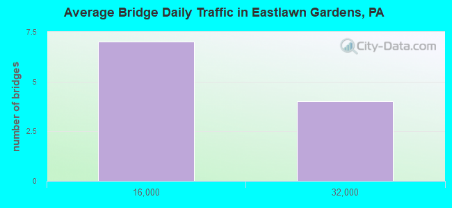
- 121,215Total average daily traffic
- 14,529Total average daily truck traffic
- National Bridge Inventory (NBI) Registered Bridges for Eastlawn Gardens
- No street view available for this location
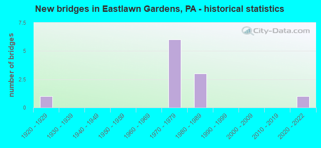
- New bridges - historical statistics
- 11920-1929
- 61970-1979
- 31980-1989
- 12020-2022
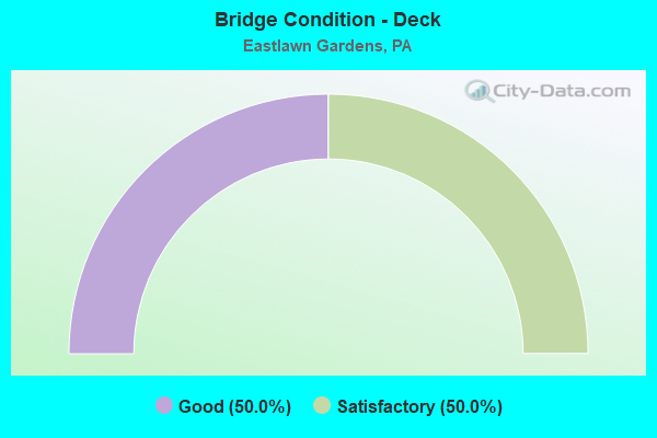
- Bridge Condition - Deck
- 50.0%Good
- 50.0%Satisfactory
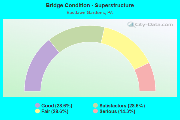
- Bridge Condition - Superstructure
- 28.6%Good
- 28.6%Satisfactory
- 28.6%Fair
- 14.3%Serious
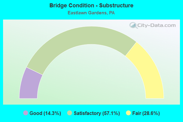
- Bridge Condition - Substructure
- 14.3%Good
- 57.1%Satisfactory
- 28.6%Fair
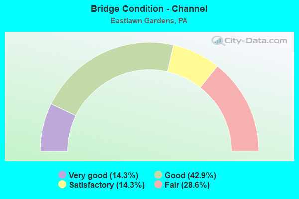
- Bridge Condition - Channel
- 14.3%Very good
- 42.9%Good
- 14.3%Satisfactory
- 28.6%Fair
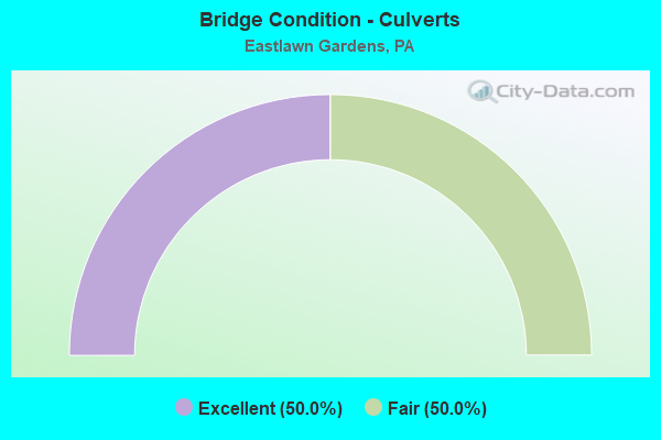
- Bridge Condition - Culverts
- 50.0%Excellent
- 50.0%Fair
Find on map >> Show street view
Structure Number: 28499, Location: 0.75 MI.N.OF PA.248 (Lat: 40.724411, Lng: -75.279117), Route carried "on" structure: State highway 33, Year Built: 1972, Year Reconstructed: 1999, Status: Open, Structure Length: 4.15m (13.62ft), Average Daily Traffic: 28,748 (year 2021), Truck Traffic: 13%, Average Future Daily Traffic: 21,401 (year 2032), Design Load: HS 20, Features Intersected: SCHOENECK CREEK
Minimum Vertical Clearance: 30+ m (98+ ft), Kilometerpoint: 9.891, Lanes on structure: 2, Base Highway Network: Yes, Owner: State Highway Agency, Approaching Roadway Width: 12.2m (40.0ft), Skew: 12 degrees, Material/Design: Prestressed concrete, Design/Construction: Stringer/Multi-beam, Number Of Spans In Main Unit: 3, Length of Maximum Span: 14.9m (48.9ft), Curb-To-Curb Width: 12.2m (40.0ft), Out-to-Out Width: 13.4m (44.0ft)
Condition: Deck: Good, Superstructure: Good, Substructure: Satisfactory, Channel: Very good, Operating Rating: 45.4 metric tons, Method Used To Determine Operating Rating: Load Factor (LF), Inventory Rating: 26.3 metric tons, Method Used To Determine Inventory Rating: Load Factor (LF), Structural Evaluation: Equal to present minimum criteria, Deck Geometry: Better than present minimum criteria, Waterway Adequacy: Superior to present desirable criteria, Approach Roadway Alignment: Equal to present desirable criteria, Length Of Structure Improvement: 5.00m (16.40ft), Designated Inspection Frequency: Every 24 months, Inspection Date: June 2021, Bridge Improvement Cost: $27,000, Roadway Improvement Cost: $80,000, Total Project Cost: $366,000, Deck Structure Type: Concrete Cast-file-Place, Wearing Surface/Protective System: Wearing Surface: Latex Concrete
Find on map >> Show street view
Structure Number: 285, Location: 0.75 MI N OF PA 248 (Lat: 40.724700, Lng: -75.279306), Route carried "on" structure: State highway 33, Year Built: 1972, Year Reconstructed: 1999, Status: Open, Structure Length: 4.15m (13.62ft), Average Daily Traffic: 28,699 (year 2021), Truck Traffic: 12%, Average Future Daily Traffic: 22,252 (year 2032), Design Load: HS 20, Features Intersected: SCHOENECK CREEK
Minimum Vertical Clearance: 30+ m (98+ ft), Kilometerpoint: 9.894, Lanes on structure: 2, Base Highway Network: Yes, Owner: State Highway Agency, Approaching Roadway Width: 12.2m (40.0ft), Skew: 12 degrees, Material/Design: Prestressed concrete, Design/Construction: Stringer/Multi-beam, Number Of Spans In Main Unit: 3, Length of Maximum Span: 14.9m (48.9ft), Curb-To-Curb Width: 12.2m (40.0ft), Out-to-Out Width: 13.4m (44.0ft)
Condition: Deck: Good, Superstructure: Good, Substructure: Satisfactory, Channel: Good, Operating Rating: 65.3 metric tons, Method Used To Determine Operating Rating: Load Factor (LF), Inventory Rating: 26.3 metric tons, Method Used To Determine Inventory Rating: Load Factor (LF), Structural Evaluation: Equal to present minimum criteria, Deck Geometry: Better than present minimum criteria, Waterway Adequacy: Superior to present desirable criteria, Approach Roadway Alignment: Equal to present desirable criteria, Length Of Structure Improvement: 5.00m (16.40ft), Designated Inspection Frequency: Every 24 months, Inspection Date: June 2021, Bridge Improvement Cost: $27,000, Roadway Improvement Cost: $80,000, Total Project Cost: $366,000, Deck Structure Type: Concrete Cast-file-Place, Wearing Surface/Protective System: Wearing Surface: Latex Concrete
Find on map >> Show street view
Structure Number: 28501, Location: 1 MI N.OF PA. 248 (Lat: 40.726925, Lng: -75.275608), Route carried "on" structure: State highway 33, Year Built: 1972, Year Reconstructed: 1999, Status: Open, Structure Length: 5.85m (19.19ft), Average Daily Traffic: 28,748 (year 2021), Truck Traffic: 13%, Average Future Daily Traffic: 21,401 (year 2032), Design Load: HS 20, Features Intersected: T-516 VAN BUREN RD.
Minimum Vertical Clearance: 30+ m (98+ ft), Kilometerpoint: 10.670, Lanes on structure: 2, Lanes under structure: 2, Base Highway Network: Yes, Owner: State Highway Agency, Approaching Roadway Width: 14.0m (45.9ft), Skew: 13 degrees, Material/Design: Steel, Design/Construction: Stringer/Multi-beam, Number Of Spans In Main Unit: 1, Number Of Approach Spans: 2, Length of Maximum Span: 32.9m (107.9ft), Curb-To-Curb Width: 12.2m (40.0ft), Out-to-Out Width: 13.4m (44.0ft)
Condition: Deck: Good, Superstructure: Satisfactory, Substructure: Satisfactory, Operating Rating: 63.5 metric tons, Method Used To Determine Operating Rating: Load Factor (LF), Inventory Rating: 38.1 metric tons, Method Used To Determine Inventory Rating: Load Factor (LF), Structural Evaluation: Equal to present minimum criteria, Deck Geometry: Better than present minimum criteria, Underclear: Equal to present minimum criteria, Approach Roadway Alignment: Equal to present desirable criteria, Length Of Structure Improvement: 6.90m (22.64ft), Designated Inspection Frequency: Every 24 months, Inspection Date: Febuary 2021, Bridge Improvement Cost: $35,000, Roadway Improvement Cost: $102,000, Total Project Cost: $468,000, Deck Structure Type: Concrete Cast-file-Place, Wearing Surface/Protective System: Wearing Surface: Latex Concrete
Find on map >> Show street view
Structure Number: 28502, Location: 1 MI N OF PA 248 (Lat: 40.727308, Lng: -75.275669), Route carried "on" structure: State highway 33, Year Built: 1972, Year Reconstructed: 1999, Status: Open, Structure Length: 5.70m (18.70ft), Average Daily Traffic: 28,699 (year 2021), Truck Traffic: 12%, Average Future Daily Traffic: 22,252 (year 2032), Design Load: HS 20, Features Intersected: T-516 VAN BUREN RD.
Minimum Vertical Clearance: 30+ m (98+ ft), Kilometerpoint: 10.668, Lanes on structure: 2, Lanes under structure: 2, Base Highway Network: Yes, Owner: State Highway Agency, Approaching Roadway Width: 14.0m (45.9ft), Skew: 13 degrees, Material/Design: Steel, Design/Construction: Stringer/Multi-beam, Number Of Spans In Main Unit: 1, Number Of Approach Spans: 2, Length of Maximum Span: 32.9m (107.9ft), Curb-To-Curb Width: 12.2m (40.0ft), Out-to-Out Width: 13.4m (44.0ft)
Condition: Deck: Satisfactory, Superstructure: Fair, Substructure: Fair, Operating Rating: 62.6 metric tons, Method Used To Determine Operating Rating: Load Factor (LF), Inventory Rating: 37.2 metric tons, Method Used To Determine Inventory Rating: Load Factor (LF), Structural Evaluation: Somewhat better than minimum adequacy, Deck Geometry: Better than present minimum criteria, Underclear: Meets minimum limits, Approach Roadway Alignment: Equal to present desirable criteria, Length Of Structure Improvement: 6.70m (21.98ft), Designated Inspection Frequency: Every 24 months, Inspection Date: Febuary 2021, Bridge Improvement Cost: $34,000, Roadway Improvement Cost: $100,000, Total Project Cost: $458,000, Deck Structure Type: Concrete Cast-file-Place, Wearing Surface/Protective System: Wearing Surface: Latex Concrete
Find on map >> Show street view
Structure Number: 28797, Location: VILLAGE OF ALUTA (Lat: 40.773467, Lng: -75.319361), Route carried "on" structure: State highway , Year Built: 1926, Status: Open, Structure Length: 1.25m (4.10ft), Average Daily Traffic: 2,521 (year 2022), Truck Traffic: 4%, Average Future Daily Traffic: 4,237 (year 2032), Design Load: HS 20, Features Intersected: WEST BR.BUSHKILL CREEK, Facility Carried by Structure: SR 4025 (LR 48043)
Minimum Vertical Clearance: 30+ m (98+ ft), Kilometerpoint: 3.375, Lanes on structure: 2, Owner: State Highway Agency, Approaching Roadway Width: 7.3m (24.0ft), Material/Design: Concrete, Design/Construction: Arch - Deck, Number Of Spans In Main Unit: 1, Length of Maximum Span: 12.2m (40.0ft), Curb-To-Curb Width: 7.1m (23.3ft), Out-to-Out Width: 7.9m (25.9ft)
Condition: Superstructure: Fair, Substructure: Fair, Channel: Fair, Operating Rating: 49.0 metric tons, Method Used To Determine Operating Rating: Field evaluation and documented engineering judgment, Inventory Rating: 32.7 metric tons, Method Used To Determine Inventory Rating: Field evaluation and documented engineering judgment, Structural Evaluation: Somewhat better than minimum adequacy, Deck Geometry: High priority of replacement, Waterway Adequacy: Equal to present desirable criteria, Approach Roadway Alignment: Equal to present desirable criteria, Length Of Structure Improvement: 1.90m (6.23ft), Designated Inspection Frequency: Every 24 months, Inspection Date: December 2020, Bridge Improvement Cost: $7,000, Roadway Improvement Cost: $21,000, Total Project Cost: $95,000
Find on map >> Show street view
Structure Number: 2881, Location: BETWEEN SR 4025 & 1001 (Lat: 40.775028, Lng: -75.309231), Route carried "on" structure: City street , Year Built: 1984, Status: Open, Structure Length: 1.43m (4.69ft), Average Daily Traffic: 150 (year 2010), Truck Traffic: 10%, Average Future Daily Traffic: 200 (year 2030), Design Load: HS 20+Mod, Features Intersected: BUSHKILL CREEK, Facility Carried by Structure: E. ALUTA MILL ROAD
Minimum Vertical Clearance: 30+ m (98+ ft), Kilometerpoint: 0.000, Lanes on structure: 2, Owner: County Highway Agency, Approaching Roadway Width: 6.1m (20.0ft), Skew: 1 degrees, Material/Design: Prestressed concrete, Design/Construction: Box Beam or Girders - Multiple, Number Of Spans In Main Unit: 1, Length of Maximum Span: 13.7m (44.9ft), Curb-To-Curb Width: 7.6m (24.9ft), Out-to-Out Width: 8.6m (28.2ft)
Condition: Deck: Satisfactory, Superstructure: Satisfactory, Substructure: Good, Channel: Good, Operating Rating: 65.3 metric tons, Method Used To Determine Operating Rating: Load Factor (LF), Inventory Rating: 34.5 metric tons, Method Used To Determine Inventory Rating: Load Factor (LF), Structural Evaluation: Equal to present minimum criteria, Deck Geometry: Somewhat better than minimum adequacy, Waterway Adequacy: Better than present minimum criteria, Approach Roadway Alignment: Equal to present desirable criteria, Length Of Structure Improvement: 2.00m (6.56ft), Designated Inspection Frequency: Every 24 months, Inspection Date: November 2020, Deck Structure Type: Concrete Precast Panels, Wearing Surface/Protective System: Wearing Surface: Bituminous, Membrane: Preformed Fabric
Find on map >> Show street view
Structure Number: 28812, Location: BETWEEN SR 4025 & 1001 (Lat: 40.780547, Lng: -75.309717), Route carried "on" structure: City street , Year Built: 1984, Status: Open, Structure Length: 1.46m (4.79ft), Average Daily Traffic: 200 (year 2010), Truck Traffic: 10%, Average Future Daily Traffic: 250 (year 2030), Design Load: HS 20, Features Intersected: BUSHKILL CREEK, Facility Carried by Structure: DOUGLASSVILLE RD.
Minimum Vertical Clearance: 30+ m (98+ ft), Kilometerpoint: 0.000, Lanes on structure: 2, Owner: County Highway Agency, Approaching Roadway Width: 6.7m (22.0ft), Material/Design: Prestressed concrete, Design/Construction: Box Beam or Girders - Multiple, Number Of Spans In Main Unit: 1, Length of Maximum Span: 13.7m (44.9ft), Curb-To-Curb Width: 8.1m (26.6ft), Out-to-Out Width: 8.6m (28.2ft)
Condition: Deck: Satisfactory, Superstructure: Serious, Substructure: Satisfactory, Channel: Fair, Operating Rating: 56.2 metric tons, Method Used To Determine Operating Rating: Load Factor (LF), Inventory Rating: 32.7 metric tons, Method Used To Determine Inventory Rating: Load Factor (LF), Structural Evaluation: High priority of corrective action, Deck Geometry: Somewhat better than minimum adequacy, Waterway Adequacy: Equal to present desirable criteria, Approach Roadway Alignment: Equal to present minimum criteria, Length Of Structure Improvement: 2.10m (6.89ft), Designated Inspection Frequency: Every 24 months, Other Special Inspection Frequency: Every 12 months, Inspection Date: March 2020, Other Special Inspection Date: March 2021, Deck Structure Type: Concrete Precast Panels, Wearing Surface/Protective System: Wearing Surface: Bituminous, Membrane: Preformed Fabric
Find on map >> Show street view
Structure Number: 49151, Location: 0.2 mi West of SR 33 (Lat: 40.727383, Lng: -75.279122), Route carried "on" structure: Business County highway 7212, Year Built: 1986, Status: Open, Structure Length: 0.61m (2.00ft), Average Daily Traffic: 1,000 (year 2009), Truck Traffic: 1%, Average Future Daily Traffic: 2,000 (year 2020), Design Load: HS 20, Features Intersected: Shoeneck Creek, Facility Carried by Structure: Hollo Road
Minimum Vertical Clearance: 30+ m (98+ ft), Kilometerpoint: 0.000, Lanes on structure: 2, Owner: Town or Township Highway Agency, Approaching Roadway Width: 7.3m (24.0ft), Material/Design: Concrete, Design/Construction: Culvert, Number Of Spans In Main Unit: 1, Length of Maximum Span: 6.1m (20.0ft), Curb or Sidewalk Widths: Left: 6.1m (20.0ft), Right: 6.1m (20.0ft), Curb-To-Curb Width: 20.9m (68.6ft), Out-to-Out Width: 21.0m (68.9ft)
Condition: Channel: Satisfactory, Culverts: Fair, Operating Rating: 69.9 metric tons, Method Used To Determine Operating Rating: Load Factor (LF), Inventory Rating: 41.7 metric tons, Method Used To Determine Inventory Rating: Load Factor (LF), Structural Evaluation: Somewhat better than minimum adequacy, Deck Geometry: Superior to present desirable criteria, Waterway Adequacy: Equal to present desirable criteria, Approach Roadway Alignment: Equal to present desirable criteria, Designated Inspection Frequency: Every 24 months, Inspection Date: March 2021, Wearing Surface/Protective System: Wearing Surface: Bituminous, Membrane: Preformed Fabric, Deck Protection: Epoxy Coated Reinforcing
Find on map >> Show street view
Structure Number: 67598, Location: East of SR 4023/4025 (Lat: 40.772328, Lng: -75.314472), Route carried "on" structure: City street , Year Built: 2020, Status: Open, Structure Length: 1.92m (6.30ft), Average Daily Traffic: 50 (year 2010), Average Future Daily Traffic: 75 (year 2030), Design Load: HL 93, Features Intersected: Bushkill Creek, Facility Carried by Structure: Aluta Mill Road
Minimum Vertical Clearance: 30+ m (98+ ft), Kilometerpoint: 0.000, Lanes on structure: 2, Owner: County Highway Agency, Approaching Roadway Width: 6.7m (22.0ft), Material/Design: Concrete, Design/Construction: Culvert, Number Of Spans In Main Unit: 1, Length of Maximum Span: 18.6m (61.0ft), Curb-To-Curb Width: 6.7m (22.0ft), Out-to-Out Width: 7.8m (25.6ft)
Condition: Channel: Good, Culverts: Excellent, Operating Rating: 47.0 metric tons, Method Used To Determine Operating Rating: Assigned ratings based on Load and Resistance Factor Design (LRFD) reported by rating factor (RF) using HL93 loadings, Inventory Rating: 35.3 metric tons, Method Used To Determine Inventory Rating: Assigned ratings based on Load and Resistance Factor Design (LRFD) reported by rating factor (RF) using HL93 loadings, Structural Evaluation: Superior to present desirable criteria, Deck Geometry: Somewhat better than minimum adequacy, Waterway Adequacy: Equal to present desirable criteria, Approach Roadway Alignment: Equal to present desirable criteria, Designated Inspection Frequency: Every 24 months, Inspection Date: August 2020
Find on map >> Show street view
Structure Number: 28501, Location: 1 MI N.OF PA. 248 (Lat: 40.726925, Lng: -75.275608), Route carried "under" structure: City street , Year Built: 1972, Structure Length: 0. m, Average Daily Traffic: 1,200 (year 1994), Truck Traffic: 1%, Features Intersected: T-516 VAN BUREN RD., Facility Carried by Structure: SR 33 NB(LR 1098)
Minimum Vertical Clearance: 4.75m (15.58ft), Kilometerpoint: 0.000, Lanes on structure: 2, Lanes under structure: 2, Material/Design: Steel, Design/Construction: Stringer/Multi-beam, Length of Maximum Span: 32.9m (107.9ft)
Find on map >> Show street view
Structure Number: 28502, Location: 1 MI N OF PA 248 (Lat: 40.727308, Lng: -75.275669), Route carried "under" structure: City street , Year Built: 1972, Structure Length: 0. m, Average Daily Traffic: 1,200 (year 1994), Truck Traffic: 1%, Features Intersected: T-516 VAN BUREN RD., Facility Carried by Structure: SR 33 SB(LR1098)
Minimum Vertical Clearance: 4.48m (14.70ft), Kilometerpoint: 0.000, Lanes on structure: 2, Lanes under structure: 2, Material/Design: Steel, Design/Construction: Stringer/Multi-beam, Length of Maximum Span: 32.9m (107.9ft)