Bridge Statistics for Eastvale, California (CA)
Condition, Traffic, Stress, Structural Evaluation, Project Costs
- National Bridge Inventory (NBI) Statistics
- 22Number of bridges
- 358ft / 109mTotal length
- 1,389,287Total average daily traffic
- 185,425Total average daily truck traffic
- National Bridge Inventory (NBI) Registered Bridges for Eastvale
- No street view available for this location
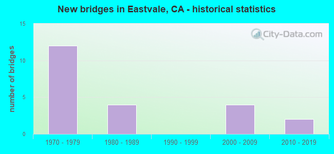
- New bridges - historical statistics
- 121970-1979
- 41980-1989
- 42000-2009
- 22010-2019
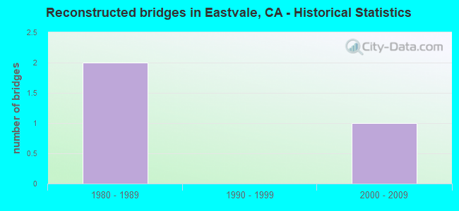
- Reconstructed bridges - Historical Statistics
- 21980-1989
- 01990-1999
- 12000-2009
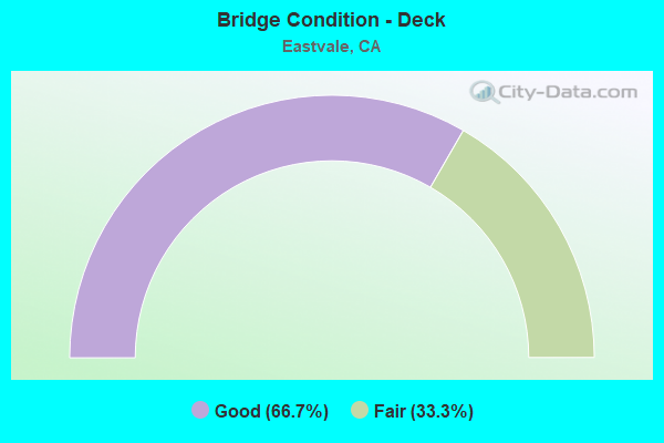
- Bridge Condition - Deck
- 66.7%Good
- 33.3%Fair
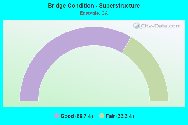
- Bridge Condition - Superstructure
- 66.7%Good
- 33.3%Fair

- Bridge Condition - Substructure
- 66.7%Good
- 33.3%Fair
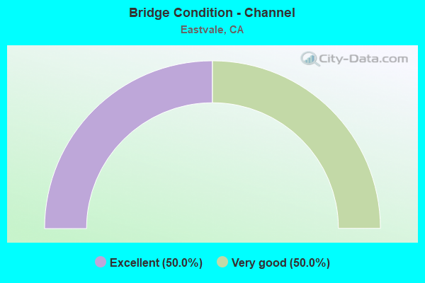
- Bridge Condition - Channel
- 50.0%Excellent
- 50.0%Very good
Find on map >> Show street view
Structure Number: 56 0664, Location: 08-RIV-015-49.36 (Lat: 33.990914, Lng: -117.550456), Route carried "on" structure: County highway , Year Built: 1988, Status: Open, Structure Length: 7.01m (23.00ft), Average Daily Traffic: 3,000 (year 2012), Truck Traffic: 1%, Average Future Daily Traffic: 3,458 (year 2039), Design Load: HS 20+Mod, Features Intersected: INTERSTATE 15, Facility Carried by Structure: BELLEGRAVE AVENUE
Minimum Vertical Clearance: 30+ m (98+ ft), Kilometerpoint: 0.000, Lanes on structure: 2, Lanes under structure: 6, Owner: State Highway Agency, Approaching Roadway Width: 12.2m (40.0ft), Skew: 1 degrees, Material/Design: Prestressed concrete continuous, Design/Construction: Box Beam or Girders - Multiple, Number Of Spans In Main Unit: 2, Length of Maximum Span: 35.7m (117.1ft), Curb or Sidewalk Widths: Left: 1.5m (4.9ft), Right: 0.0m, Curb-To-Curb Width: 12.2m (40.0ft), Out-to-Out Width: 14.6m (47.9ft)
Condition: Deck: Good, Superstructure: Good, Substructure: Good, Operating Rating: 54.1 metric tons, Method Used To Determine Operating Rating: Assigned rating based on Load Factor Design (LFD) reported in metric tons, Inventory Rating: 32.4 metric tons, Method Used To Determine Inventory Rating: Assigned rating based on Load Factor Design (LFD) reported in metric tons, Structural Evaluation: Better than present minimum criteria, Deck Geometry: Equal to present minimum criteria, Underclear: Equal to present minimum criteria, Approach Roadway Alignment: Superior to present desirable criteria, Designated Inspection Frequency: Every 24 months, Inspection Date: April 2020, Deck Structure Type: Concrete Cast-file-Place
Find on map >> Show street view
Structure Number: 56 0685G, Location: 08-RIV-060-R0.15 (Lat: 34.022894, Lng: -117.556117), Route carried "on" structure: Ramp State highway 60, Year Built: 1979, Status: Open, Structure Length: 11.91m (39.07ft), Average Daily Traffic: 15,500 (year 2016), Truck Traffic: 14%, Average Future Daily Traffic: 20,403 (year 2039), Design Load: HS 20+Mod, Features Intersected: MILLIKEN AV-E60 ON-RAMP
Minimum Vertical Clearance: 30+ m (98+ ft), Kilometerpoint: 0.150, Lanes on structure: 2, Lanes under structure: 1, Base Highway Network: Yes (, Subroute: 1), Owner: State Highway Agency, Approaching Roadway Width: 11.7m (38.4ft), Material/Design: Prestressed concrete continuous, Design/Construction: Box Beam or Girders - Multiple, Number Of Spans In Main Unit: 4, Length of Maximum Span: 30.5m (100.1ft), Curb-To-Curb Width: 11.7m (38.4ft), Out-to-Out Width: 12.8m (42.0ft)
Condition: Deck: Fair, Superstructure: Fair, Substructure: Fair, Operating Rating: 99.8 metric tons, Method Used To Determine Operating Rating: Load Factor (LF), Inventory Rating: 70.6 metric tons, Method Used To Determine Inventory Rating: Load Factor (LF), Structural Evaluation: Somewhat better than minimum adequacy, Deck Geometry: Superior to present desirable criteria, Underclear: Somewhat better than minimum adequacy, Approach Roadway Alignment: Equal to present desirable criteria, Designated Inspection Frequency: Every 24 months, Inspection Date: December 2021, Deck Structure Type: Concrete Cast-file-Place
Find on map >> Show street view
Structure Number: 56 0687G, Location: 08-RIV-060-R0.44 (Lat: 34.021669, Lng: -117.552328), Route carried "on" structure: Ramp US 60, Year Built: 1979, Status: Open, Structure Length: 36.89m (121.03ft), Average Daily Traffic: 16,500 (year 2016), Truck Traffic: 18%, Average Future Daily Traffic: 20,403 (year 2039), Design Load: HS 20+Mod, Features Intersected: ROUTE 15 & ROUTE 60
Minimum Vertical Clearance: 5.44m (17.85ft), Kilometerpoint: 0.440, Lanes on structure: 2, Lanes under structure: 19, Base Highway Network: Yes (, Subroute: 1), Owner: State Highway Agency, Approaching Roadway Width: 11.7m (38.4ft), Skew: 9 degrees, Material/Design: Prestressed concrete continuous, Design/Construction: Box Beam or Girders - Multiple, Number Of Spans In Main Unit: 9, Length of Maximum Span: 52.0m (170.6ft), Curb-To-Curb Width: 11.7m (38.4ft), Out-to-Out Width: 12.8m (42.0ft)
Condition: Deck: Fair, Superstructure: Fair, Substructure: Fair, Operating Rating: 99.8 metric tons, Method Used To Determine Operating Rating: Load Factor (LF), Inventory Rating: 32.4 metric tons, Method Used To Determine Inventory Rating: Load Factor (LF), Structural Evaluation: Somewhat better than minimum adequacy, Deck Geometry: Superior to present desirable criteria, Underclear: Equal to present minimum criteria, Approach Roadway Alignment: Equal to present desirable criteria, Designated Inspection Frequency: Every 24 months, Inspection Date: December 2021, Deck Structure Type: Concrete Cast-file-Place
Find on map >> Show street view
Structure Number: 56 0691L, Location: 08-RIV-015-51.45 (Lat: 34.021417, Lng: -117.550400), Route carried "on" structure: Interstate 15, Year Built: 1979, Year Reconstructed: 1987, Status: Open, Structure Length: 8.35m (27.40ft), Average Daily Traffic: 67,450 (year 2012), Truck Traffic: 16%, Average Future Daily Traffic: 192,046 (year 2039), Design Load: HS 20+Mod, Features Intersected: STATE ROUTE 60
Minimum Vertical Clearance: 5.18m (16.99ft), Kilometerpoint: 51.450, Lanes on structure: 3, Lanes under structure: 11, Base Highway Network: Yes (, Subroute: 1), Owner: State Highway Agency, Approaching Roadway Width: 15.4m (50.5ft), Skew: 1 degrees, Material/Design: Prestressed concrete continuous, Design/Construction: Box Beam or Girders - Multiple, Number Of Spans In Main Unit: 2, Length of Maximum Span: 42.4m (139.1ft), Curb or Sidewalk Widths: Left: 0.2m (0.7ft), Right: 0.2m (0.7ft), Curb-To-Curb Width: 15.4m (50.5ft), Out-to-Out Width: 16.5m (54.1ft)
Condition: Deck: Good, Superstructure: Good, Substructure: Good, Operating Rating: 45.0 metric tons, Method Used To Determine Operating Rating: Load and Resistance Factor Rating (LRFR) rating reported by rating factor(RF) method using HL-93 loadings, Inventory Rating: 33.7 metric tons, Method Used To Determine Inventory Rating: Load and Resistance Factor Rating (LRFR) rating reported by rating factor(RF) method using HL-93 loadings, Structural Evaluation: Better than present minimum criteria, Deck Geometry: Somewhat better than minimum adequacy, Underclear: Better than present minimum criteria, Approach Roadway Alignment: Superior to present desirable criteria, Designated Inspection Frequency: Every 24 months, Inspection Date: April 2020, Deck Structure Type: Concrete Cast-file-Place
Find on map >> Show street view
Structure Number: 56 0693L, Location: 08-RIV-015-51.26 (Lat: 34.018653, Lng: -117.550414), Route carried "on" structure: Interstate 15, Year Built: 1987, Status: Not yet open, Structure Length: 3.15m (10.33ft), Average Daily Traffic: 72,500 (year 2012), Truck Traffic: 16%, Average Future Daily Traffic: 105,800 (year 2039), Design Load: HS 20+Mod, Features Intersected: RIVERSIDE DRIVE
Minimum Vertical Clearance: 30+ m (98+ ft), Kilometerpoint: 51.260, Lanes on structure: 4, Lanes under structure: 2, Base Highway Network: Yes (, Subroute: 1), Owner: State Highway Agency, Approaching Roadway Width: 20.3m (66.6ft), Material/Design: Prestressed concrete, Design/Construction: Box Beam or Girders - Multiple, Number Of Spans In Main Unit: 1, Length of Maximum Span: 31.5m (103.3ft), Curb-To-Curb Width: 20.3m (66.6ft), Out-to-Out Width: 21.4m (70.2ft)
Condition: Deck: Good, Superstructure: Good, Substructure: Good, Operating Rating: 54.1 metric tons, Method Used To Determine Operating Rating: Assigned rating based on Load Factor Design (LFD) reported in metric tons, Inventory Rating: 32.4 metric tons, Method Used To Determine Inventory Rating: Assigned rating based on Load Factor Design (LFD) reported in metric tons, Structural Evaluation: Better than present minimum criteria, Deck Geometry: Equal to present minimum criteria, Underclear: Equal to present minimum criteria, Approach Roadway Alignment: Superior to present desirable criteria, Designated Inspection Frequency: Every 24 months, Inspection Date: April 2020, Deck Structure Type: Concrete Cast-file-Place
Find on map >> Show street view
Structure Number: 56 0695L, Location: 08-RIV-015-51.95 (Lat: 34.028653, Lng: -117.550392), Route carried "on" structure: Interstate 15, Year Built: 1979, Year Reconstructed: 1987, Status: Open, Structure Length: 10.66m (34.97ft), Average Daily Traffic: 107,000 (year 2012), Truck Traffic: 8%, Average Future Daily Traffic: 129,550 (year 2040), Design Load: HS 20+Mod, Features Intersected: MISSION BLVD & UP RR
Minimum Vertical Clearance: 30+ m (98+ ft), Kilometerpoint: 51.950, Lanes on structure: 5, Lanes under structure: 4, Base Highway Network: Yes (, Subroute: 1), Owner: State Highway Agency, Approaching Roadway Width: 24.7m (81.0ft), Skew: 3 degrees, Material/Design: Prestressed concrete continuous, Design/Construction: Box Beam or Girders - Multiple, Number Of Spans In Main Unit: 4, Length of Maximum Span: 32.7m (107.3ft), Curb or Sidewalk Widths: Left: 0.5m (1.6ft), Right: 0.5m (1.6ft), Curb-To-Curb Width: 24.7m (81.0ft), Out-to-Out Width: 25.8m (84.6ft)
Condition: Deck: Good, Superstructure: Fair, Substructure: Good, Operating Rating: 54.1 metric tons, Method Used To Determine Operating Rating: Assigned rating based on Load Factor Design (LFD) reported in metric tons, Inventory Rating: 32.4 metric tons, Method Used To Determine Inventory Rating: Assigned rating based on Load Factor Design (LFD) reported in metric tons, Structural Evaluation: Somewhat better than minimum adequacy, Deck Geometry: Better than present minimum criteria, Underclear: Equal to present minimum criteria, Approach Roadway Alignment: Superior to present desirable criteria, Designated Inspection Frequency: Every 24 months, Inspection Date: April 2020, Deck Structure Type: Concrete Cast-file-Place
Find on map >> Show street view
Structure Number: 56 0797, Location: 08-RIV-015-49.93 (Lat: 34.001867, Lng: -117.550975), Route carried "on" structure: City street , Year Built: 2008, Status: Open, Structure Length: 12.90m (42.32ft), Average Daily Traffic: 5,000 (year 2012), Truck Traffic: 5%, Average Future Daily Traffic: 7,500 (year 2039), Design Load: HS 20+Mod, Features Intersected: INTERSATE 15, Facility Carried by Structure: CANTU-GALLEANO RAN
Minimum Vertical Clearance: 30+ m (98+ ft), Kilometerpoint: 0.000, Lanes on structure: 7, Lanes under structure: 9, Owner: State Highway Agency, Approaching Roadway Width: 37.9m (124.3ft), Skew: 12 degrees, Material/Design: Prestressed concrete continuous, Design/Construction: Box Beam or Girders - Multiple, Number Of Spans In Main Unit: 2, Length of Maximum Span: 66.0m (216.5ft), Curb or Sidewalk Widths: Left: 0.0m, Right: 1.8m (5.9ft), Curb-To-Curb Width: 37.9m (124.3ft), Out-to-Out Width: 40.4m (132.5ft)
Condition: Deck: Good, Superstructure: Good, Substructure: Good, Operating Rating: 54.1 metric tons, Method Used To Determine Operating Rating: Assigned rating based on Load Factor Design (LFD) reported in metric tons, Inventory Rating: 32.4 metric tons, Method Used To Determine Inventory Rating: Assigned rating based on Load Factor Design (LFD) reported in metric tons, Structural Evaluation: Better than present minimum criteria, Deck Geometry: Superior to present desirable criteria, Underclear: Equal to present minimum criteria, Approach Roadway Alignment: Equal to present desirable criteria, Designated Inspection Frequency: Every 24 months, Inspection Date: April 2020, Deck Structure Type: Concrete Cast-file-Place
Find on map >> Show street view
Structure Number: 56 0881, Location: 08-RIV-015-48.26 (Lat: 33.975139, Lng: -117.549500), Route carried "on" structure: City street , Year Built: 2019, Status: Open, Structure Length: 11.58m (37.99ft), Average Daily Traffic: 12,000 (year 2020), Truck Traffic: 4%, Average Future Daily Traffic: 18,000 (year 2040), Design Load: HL 93, Features Intersected: INTERSTATE 15, Facility Carried by Structure: LIMONITE AVENUE
Minimum Vertical Clearance: 30+ m (98+ ft), Kilometerpoint: 0.000, Lanes on structure: 8, Lanes under structure: 10, Base Highway Network: Yes (, Subroute: 1), Owner: State Highway Agency, Approaching Roadway Width: 24.0m (78.7ft), Material/Design: Prestressed concrete, Design/Construction: Box Beam or Girders - Multiple, Number Of Spans In Main Unit: 2, Length of Maximum Span: 57.9m (190.0ft), Curb or Sidewalk Widths: Left: 2.4m (7.9ft), Right: 2.4m (7.9ft), Curb-To-Curb Width: 24.0m (78.7ft), Out-to-Out Width: 24.0m (78.7ft)
Condition: Deck: Good, Superstructure: Good, Substructure: Good, Operating Rating: 42.1 metric tons, Method Used To Determine Operating Rating: Assigned ratings based on Load and Resistance Factor Design (LRFD) reported by rating factor (RF) using HL93 loadings, Inventory Rating: 32.4 metric tons, Method Used To Determine Inventory Rating: Assigned ratings based on Load and Resistance Factor Design (LRFD) reported by rating factor (RF) using HL93 loadings, Structural Evaluation: Better than present minimum criteria, Deck Geometry: High priority of replacement, Underclear: Equal to present minimum criteria, Approach Roadway Alignment: Equal to present desirable criteria, Designated Inspection Frequency: Every 24 months, Inspection Date: June 2020, Deck Structure Type: Concrete Cast-file-Place
Find on map >> Show street view
Structure Number: 56C0269, Location: 0.5 MI. W/O ARCHIBALD AVE (Lat: 33.960611, Lng: -117.602153), Route carried "on" structure: County highway , Year Built: 1977, Year Reconstructed: 2013, Status: Open, Structure Length: 4.66m (15.29ft), Average Daily Traffic: 8,391 (year 2011), Truck Traffic: 10%, Average Future Daily Traffic: 16,000 (year 2038), Design Load: HS 20, Features Intersected: CUCAMONGA CREEK, Facility Carried by Structure: SCHLEISMAN ROAD
Minimum Vertical Clearance: 30+ m (98+ ft), Kilometerpoint: 0.000, Lanes on structure: 6, Owner: County Highway Agency, Approaching Roadway Width: 21.3m (69.9ft), Material/Design: Concrete continuous, Design/Construction: Tee Beam, Number Of Spans In Main Unit: 3, Length of Maximum Span: 17.7m (58.1ft), Curb or Sidewalk Widths: Left: 1.5m (4.9ft), Right: 1.5m (4.9ft), Curb-To-Curb Width: 33.7m (110.6ft), Out-to-Out Width: 37.3m (122.4ft)
Condition: Deck: Fair, Superstructure: Good, Substructure: Fair, Channel: Excellent, Operating Rating: 99.8 metric tons, Method Used To Determine Operating Rating: Load Factor (LF), Inventory Rating: 63.8 metric tons, Method Used To Determine Inventory Rating: Load Factor (LF), Structural Evaluation: Somewhat better than minimum adequacy, Deck Geometry: Superior to present desirable criteria, Waterway Adequacy: Superior to present desirable criteria, Approach Roadway Alignment: Equal to present desirable criteria, Designated Inspection Frequency: Every 24 months, Inspection Date: March 2020, Deck Structure Type: Concrete Cast-file-Place
Find on map >> Show street view
Structure Number: 56C0343, Location: 0.1 MI. N/O CHANDLER ST. (Lat: 33.947878, Lng: -117.610892), Route carried "on" structure: County highway , Year Built: 1972, Status: Open, Structure Length: 1.62m (5.31ft), Average Daily Traffic: 2,971 (year 2011), Truck Traffic: 2%, Average Future Daily Traffic: 2,159 (year 2042), Features Intersected: CHANDLER STREET CHANNEL, Facility Carried by Structure: HELLMAN AVENUE
Minimum Vertical Clearance: 30+ m (98+ ft), Kilometerpoint: 0.000, Lanes on structure: 2, Owner: County Highway Agency, Approaching Roadway Width: 10.4m (34.1ft), Material/Design: Concrete, Design/Construction: Culvert, Number Of Spans In Main Unit: 5, Length of Maximum Span: 3.0m (9.8ft), Curb or Sidewalk Widths: Left: 0.3m (1.0ft), Right: 0.3m (1.0ft), Curb-To-Curb Width: 10.4m (34.1ft), Out-to-Out Width: 20.7m (67.9ft)
Condition: Channel: Very good, Culverts: Good, Operating Rating: 40.5 metric tons, Method Used To Determine Operating Rating: Field evaluation and documented engineering judgment, Inventory Rating: 24.3 metric tons, Method Used To Determine Inventory Rating: Field evaluation and documented engineering judgment, Structural Evaluation: Equal to present minimum criteria, Deck Geometry: Somewhat better than minimum adequacy, Waterway Adequacy: Equal to present desirable criteria, Approach Roadway Alignment: Equal to present desirable criteria, Designated Inspection Frequency: Every 24 months, Inspection Date: March 2020
Find on map >> Show street view
Structure Number: 56 0664, Location: 08-RIV-015-49.36 (Lat: 33.990914, Lng: -117.550456), Route carried "under" structure: Interstate 15, Year Built: 1988, Structure Length: 0. m, Average Daily Traffic: 145,000 (year 2012), Truck Traffic: 16%, Features Intersected: INTERSTATE 15, Facility Carried by Structure: BELLEGRAVE AVENUE
Minimum Vertical Clearance: 5.41m (17.75ft), Kilometerpoint: 49.360, Lanes on structure: 2, Lanes under structure: 6, Material/Design: Prestressed concrete continuous, Design/Construction: Box Beam or Girders - Multiple, Length of Maximum Span: 35.7m (117.1ft)
Find on map >> Show street view
Structure Number: 56 0685G, Location: 08-RIV-060-R0.15 (Lat: 34.022894, Lng: -117.556117), Route carried "under" structure: Ramp State highway 60, Year Built: 1979, Structure Length: 0. m, Average Daily Traffic: 3,635 (year 2016), Truck Traffic: 2%, Features Intersected: MILLIKEN AV-E60 ON-RAMP
Minimum Vertical Clearance: 4.87m (15.98ft), Kilometerpoint: 0.150, Lanes on structure: 2, Lanes under structure: 1, Material/Design: Prestressed concrete continuous, Design/Construction: Box Beam or Girders - Multiple, Length of Maximum Span: 30.5m (100.1ft)
Find on map >> Show street view
Structure Number: 56 0687G, Location: 08-RIV-060-R0.44 (Lat: 34.021669, Lng: -117.552328), Route carried "under" structure: Interstate 15, Year Built: 1979, Structure Length: 0. m, Average Daily Traffic: 219,000 (year 2016), Truck Traffic: 9%, Features Intersected: ROUTE 15 & ROUTE 60
Minimum Vertical Clearance: 5.18m (16.99ft), Kilometerpoint: 51.450, Lanes on structure: 2, Lanes under structure: 6, Material/Design: Prestressed concrete continuous, Design/Construction: Box Beam or Girders - Multiple, Length of Maximum Span: 52.0m (170.6ft)
Find on map >> Show street view
Structure Number: 56 0687G, Location: 08-RIV-060-R0.44 (Lat: 34.021669, Lng: -117.552328), Route carried "under" structure: Ramp Interstate 15, Year Built: 1979, Structure Length: 0. m, Average Daily Traffic: 21,400 (year 2016), Truck Traffic: 8%, Features Intersected: ROUTE 15 & ROUTE 60
Minimum Vertical Clearance: 5.23m (17.16ft), Kilometerpoint: 51.450, Lanes on structure: 2, Lanes under structure: 2, Material/Design: Prestressed concrete continuous, Design/Construction: Box Beam or Girders - Multiple, Length of Maximum Span: 52.0m (170.6ft)
Find on map >> Show street view
Structure Number: 56 0687G, Location: 08-RIV-060-R0.44 (Lat: 34.021669, Lng: -117.552328), Route carried "under" structure: State highway 60, Year Built: 1979, Structure Length: 0. m, Average Daily Traffic: 162,000 (year 2016), Truck Traffic: 16%, Features Intersected: ROUTE 15 & ROUTE 60
Minimum Vertical Clearance: 11.38m (37.34ft), Kilometerpoint: 0.440, Lanes on structure: 2, Lanes under structure: 11, Material/Design: Prestressed concrete continuous, Design/Construction: Box Beam or Girders - Multiple, Length of Maximum Span: 52.0m (170.6ft)
Find on map >> Show street view
Structure Number: 56 0691L, Location: 08-RIV-015-51.45 (Lat: 34.021417, Lng: -117.550400), Route carried "under" structure: State highway 60, Year Built: 1979, Structure Length: 0. m, Average Daily Traffic: 71,950 (year 2012), Truck Traffic: 16%, Features Intersected: STATE ROUTE 60, Facility Carried by Structure: INTERSTATE 15 SB
Minimum Vertical Clearance: 5.77m (18.93ft), Kilometerpoint: 0.480, Lanes on structure: 3, Lanes under structure: 11, Material/Design: Prestressed concrete continuous, Design/Construction: Box Beam or Girders - Multiple, Length of Maximum Span: 42.4m (139.1ft)
Find on map >> Show street view
Structure Number: 56 0695L, Location: 08-RIV-015-51.95 (Lat: 34.028653, Lng: -117.550392), Route carried "under" structure: County highway R093, Year Built: 1979, Structure Length: 0. m, Average Daily Traffic: 5,000 (year 2012), Truck Traffic: 1%, Features Intersected: MISSION BLVD & UP RR, Facility Carried by Structure: INTERSTATE 15 SB
Minimum Vertical Clearance: 6.88m (22.57ft), Kilometerpoint: 0.000, Lanes on structure: 5, Lanes under structure: 4, Material/Design: Prestressed concrete continuous, Design/Construction: Box Beam or Girders - Multiple, Length of Maximum Span: 32.7m (107.3ft)
Find on map >> Show street view
Structure Number: 56 0701, Location: 08-RIV-015-47.52 (Lat: 33.964486, Lng: -117.549228), Route carried "under" structure: Interstate 15, Year Built: 1988, Structure Length: 0. m, Average Daily Traffic: 150,000 (year 2012), Truck Traffic: 16%, Features Intersected: INTERSTATE 15, Facility Carried by Structure: 68TH STREET
Minimum Vertical Clearance: 5.38m (17.65ft), Kilometerpoint: 47.520, Lanes on structure: 2, Lanes under structure: 6, Material/Design: Prestressed concrete continuous, Design/Construction: Box Beam or Girders - Multiple, Length of Maximum Span: 34.4m (112.9ft)
Find on map >> Show street view
Structure Number: 56 0797, Location: 08-RIV-015-49.93 (Lat: 34.001867, Lng: -117.550975), Route carried "under" structure: Ramp Interstate 15, Year Built: 2008, Structure Length: 0. m, Average Daily Traffic: 1,290 (year 2012), Truck Traffic: 5%, Features Intersected: INTERSATE 15, Facility Carried by Structure: CANTU-GALLEANO RAN
Minimum Vertical Clearance: 6.57m (21.56ft), Kilometerpoint: 49.930, Lanes on structure: 7, Lanes under structure: 1, Material/Design: Prestressed concrete continuous, Design/Construction: Box Beam or Girders - Multiple, Length of Maximum Span: 66.0m (216.5ft)
Find on map >> Show street view
Structure Number: 56 0797, Location: 08-RIV-015-49.93 (Lat: 34.001867, Lng: -117.550975), Route carried "under" structure: Interstate 15, Year Built: 2008, Structure Length: 0. m, Average Daily Traffic: 145,000 (year 2012), Truck Traffic: 16%, Features Intersected: INTERSATE 15, Facility Carried by Structure: CANTU-GALLEANO RAN
Minimum Vertical Clearance: 6.17m (20.24ft), Kilometerpoint: 49.930, Lanes on structure: 7, Lanes under structure: 6, Material/Design: Prestressed concrete continuous, Design/Construction: Box Beam or Girders - Multiple, Length of Maximum Span: 66.0m (216.5ft)
Find on map >> Show street view
Structure Number: 56 0797, Location: 08-RIV-015-49.93 (Lat: 34.001867, Lng: -117.550975), Route carried "under" structure: Ramp Interstate 15, Year Built: 2008, Structure Length: 0. m, Average Daily Traffic: 4,700 (year 2012), Truck Traffic: 5%, Features Intersected: INTERSATE 15, Facility Carried by Structure: CANTU-GALLEANO RAN
Minimum Vertical Clearance: 6.22m (20.41ft), Kilometerpoint: 49.930, Lanes on structure: 7, Lanes under structure: 2, Material/Design: Prestressed concrete continuous, Design/Construction: Box Beam or Girders - Multiple, Length of Maximum Span: 66.0m (216.5ft)
Find on map >> Show street view
Structure Number: 56 0881, Location: 08-RIV-015-48.26 (Lat: 33.975139, Lng: -117.549500), Route carried "under" structure: Interstate 15, Year Built: 2019, Structure Length: 0. m, Average Daily Traffic: 150,000 (year 2012), Truck Traffic: 12%, Features Intersected: INTERSTATE 15, Facility Carried by Structure: LIMONITE AVENUE
Minimum Vertical Clearance: 5.66m (18.57ft), Kilometerpoint: 48.260, Lanes on structure: 8, Lanes under structure: 10, Material/Design: Prestressed concrete, Design/Construction: Box Beam or Girders - Multiple, Length of Maximum Span: 57.9m (190.0ft)