Bridge Statistics for Edgewood, Ohio (OH)
Condition, Traffic, Stress, Structural Evaluation, Project Costs
- National Bridge Inventory (NBI) Statistics
- 45Number of bridges
- 876ft / 267mTotal length
- 313,272Total average daily traffic
- 67,688Total average daily truck traffic
- National Bridge Inventory (NBI) Registered Bridges for Edgewood
- No street view available for this location
- New bridges - historical statistics
- 1Before 1900
- 31900-1909
- 11920-1929
- 11940-1949
- 131950-1959
- 221960-1969
- 11990-1999
- 32010-2019
- Reconstructed bridges - Historical Statistics
- 81990-1999
- 92000-2009
- 32010-2019
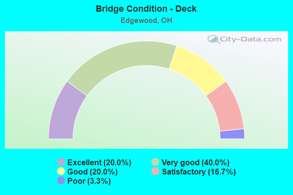
- Bridge Condition - Deck
- 20.0%Excellent
- 40.0%Very good
- 20.0%Good
- 16.7%Satisfactory
- 3.3%Poor
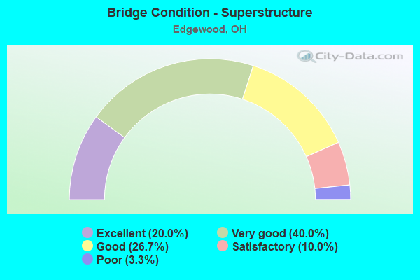
- Bridge Condition - Superstructure
- 20.0%Excellent
- 40.0%Very good
- 26.7%Good
- 10.0%Satisfactory
- 3.3%Poor
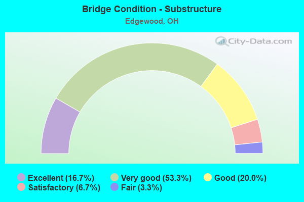
- Bridge Condition - Substructure
- 16.7%Excellent
- 53.3%Very good
- 20.0%Good
- 6.7%Satisfactory
- 3.3%Fair
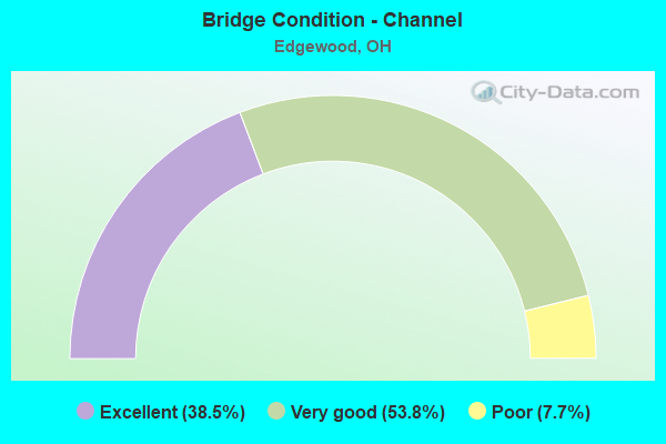
- Bridge Condition - Channel
- 38.5%Excellent
- 53.8%Very good
- 7.7%Poor
Find on map >> Show street view
Structure Number: 401447, Location: 1.18 MI N OF SR 46 (Lat: 41.827489, Lng: -80.765489), Route carried "on" structure: State highway 11, Year Built: 1959, Year Reconstructed: 2013, Status: Open, Structure Length: 11.14m (36.55ft), Average Daily Traffic: 3,263 (year 2015), Truck Traffic: 15%, Average Future Daily Traffic: 4,529 (year 2035), Design Load: HS 25 or greater, Features Intersected: OVER ATB-IR 90-13.61
Minimum Vertical Clearance: 30+ m (98+ ft), Kilometerpoint: 37.707, Lanes on structure: 3, Lanes under structure: 6, Base Highway Network: Yes, Owner: State Highway Agency, Approaching Roadway Width: 17.4m (57.1ft), Material/Design: Steel continuous, Design/Construction: Stringer/Multi-beam, Number Of Spans In Main Unit: 6, Length of Maximum Span: 25.0m (82.0ft), Curb-To-Curb Width: 17.4m (57.1ft), Out-to-Out Width: 18.3m (60.0ft)
Condition: Deck: Excellent, Superstructure: Excellent, Substructure: Very good, Operating Rating: 42.1 metric tons, Method Used To Determine Operating Rating: Allowable Stress (AS) rating reported by rating factor (RF) method using MS18 loading, Inventory Rating: 32.4 metric tons, Method Used To Determine Inventory Rating: Allowable Stress (AS) rating reported by rating factor (RF) method using MS18 loading, Structural Evaluation: Equal to present desirable criteria, Deck Geometry: Superior to present desirable criteria, Underclear: High priority of corrective action, Approach Roadway Alignment: Equal to present desirable criteria, Designated Inspection Frequency: Every 24 months, Inspection Date: December 2021, Deck Structure Type: Concrete Cast-file-Place, Wearing Surface/Protective System: Wearing Surface: Monolithic Concrete, Deck Protection: Epoxy Coated Reinforcing
Find on map >> Show street view
Structure Number: 401471, Location: 1.18 MI N OF SR 46 (Lat: 41.827489, Lng: -80.765131), Route carried "on" structure: State highway 11, Year Built: 1959, Year Reconstructed: 2014, Status: Open, Structure Length: 11.14m (36.55ft), Average Daily Traffic: 3,263 (year 2015), Truck Traffic: 15%, Average Future Daily Traffic: 4,529 (year 2035), Design Load: HS 20+Mod, Features Intersected: OVER ATB-IR 90-13.63
Minimum Vertical Clearance: 30+ m (98+ ft), Kilometerpoint: 37.707, Lanes on structure: 3, Lanes under structure: 6, Base Highway Network: Yes, Owner: State Highway Agency, Approaching Roadway Width: 17.4m (57.1ft), Material/Design: Steel continuous, Design/Construction: Stringer/Multi-beam, Number Of Spans In Main Unit: 6, Length of Maximum Span: 25.2m (82.7ft), Curb-To-Curb Width: 17.4m (57.1ft), Out-to-Out Width: 18.3m (60.0ft)
Condition: Deck: Excellent, Superstructure: Excellent, Substructure: Excellent, Operating Rating: 42.1 metric tons, Method Used To Determine Operating Rating: Load Factor (LF) rating reported by rating factor (RF) method using MS18 loading, Inventory Rating: 32.4 metric tons, Method Used To Determine Inventory Rating: Load Factor (LF) rating reported by rating factor (RF) method using MS18 loading, Structural Evaluation: Equal to present desirable criteria, Deck Geometry: Superior to present desirable criteria, Underclear: High priority of corrective action, Approach Roadway Alignment: Equal to present desirable criteria, Designated Inspection Frequency: Every 24 months, Inspection Date: December 2021, Deck Structure Type: Concrete Cast-file-Place, Wearing Surface/Protective System: Wearing Surface: Monolithic Concrete
Find on map >> Show street view
Structure Number: 401501, Location: 0.39 MI N OF IR 90 (Lat: 41.833181, Lng: -80.766081), Route carried "on" structure: County highway T0328, Year Built: 1961, Status: Open, Structure Length: 7.68m (25.20ft), Average Daily Traffic: 641 (year 2015), Truck Traffic: 7%, Average Future Daily Traffic: 890 (year 2035), Design Load: H 15, Features Intersected: SR 11, Facility Carried by Structure: GARRISON RD TR 328
Minimum Vertical Clearance: 30+ m (98+ ft), Kilometerpoint: 3.159, Lanes on structure: 2, Lanes under structure: 5, Owner: State Highway Agency, Approaching Roadway Width: 7.3m (24.0ft), Material/Design: Steel continuous, Design/Construction: Stringer/Multi-beam, Number Of Spans In Main Unit: 4, Length of Maximum Span: 24.1m (79.1ft), Curb-To-Curb Width: 7.3m (24.0ft), Out-to-Out Width: 8.5m (27.9ft)
Condition: Deck: Satisfactory, Superstructure: Satisfactory, Substructure: Very good, Operating Rating: 42.1 metric tons, Method Used To Determine Operating Rating: Load Factor (LF) rating reported by rating factor (RF) method using MS18 loading, Inventory Rating: 32.4 metric tons, Method Used To Determine Inventory Rating: Load Factor (LF) rating reported by rating factor (RF) method using MS18 loading, Structural Evaluation: Equal to present minimum criteria, Deck Geometry: Meets minimum limits, Underclear: High priority of corrective action, Approach Roadway Alignment: Equal to present desirable criteria, Designated Inspection Frequency: Every 12 months, Inspection Date: December 2021, Deck Structure Type: Concrete Cast-file-Place, Wearing Surface/Protective System: Wearing Surface: Integral Concrete
Find on map >> Show street view
Structure Number: 401536, Location: 1.16 MI N OF IR 90 (Lat: 41.844231, Lng: -80.766000), Route carried "on" structure: County highway 329, Year Built: 1961, Year Reconstructed: 2001, Status: Open, Structure Length: 8.69m (28.51ft), Average Daily Traffic: 1,297 (year 2016), Truck Traffic: 7%, Average Future Daily Traffic: 1,800 (year 2036), Design Load: HS 20, Features Intersected: SR 11
Minimum Vertical Clearance: 30+ m (98+ ft), Kilometerpoint: 1.197, Lanes on structure: 2, Lanes under structure: 4, Owner: State Highway Agency, Approaching Roadway Width: 7.3m (24.0ft), Material/Design: Steel continuous, Design/Construction: Stringer/Multi-beam, Number Of Spans In Main Unit: 4, Length of Maximum Span: 28.0m (91.9ft), Curb-To-Curb Width: 10.1m (33.1ft), Out-to-Out Width: 11.0m (36.1ft)
Condition: Deck: Very good, Superstructure: Very good, Substructure: Good, Operating Rating: 42.1 metric tons, Method Used To Determine Operating Rating: Load Factor (LF) rating reported by rating factor (RF) method using MS18 loading, Inventory Rating: 32.4 metric tons, Method Used To Determine Inventory Rating: Load Factor (LF) rating reported by rating factor (RF) method using MS18 loading, Structural Evaluation: Better than present minimum criteria, Deck Geometry: Somewhat better than minimum adequacy, Underclear: High priority of corrective action, Approach Roadway Alignment: Equal to present desirable criteria, Designated Inspection Frequency: Every 24 months, Inspection Date: December 2021, Deck Structure Type: Concrete Cast-file-Place, Wearing Surface/Protective System: Wearing Surface: Monolithic Concrete, Deck Protection: Epoxy Coated Reinforcing
Find on map >> Show street view
Structure Number: 401625, Location: 0.81 MI S OF SR 84 (Lat: 41.851889, Lng: -80.767550), Route carried "on" structure: County highway 20, Year Built: 1961, Year Reconstructed: 2001, Status: Open, Structure Length: 7.07m (23.20ft), Average Daily Traffic: 1,097 (year 2016), Truck Traffic: 5%, Average Future Daily Traffic: 1,523 (year 2036), Design Load: HS 20+Mod, Features Intersected: SR 11, Facility Carried by Structure: PLYMOUTH RIDGE RD
Minimum Vertical Clearance: 30+ m (98+ ft), Kilometerpoint: 1.313, Lanes on structure: 2, Lanes under structure: 4, Owner: State Highway Agency, Approaching Roadway Width: 7.9m (25.9ft), Material/Design: Steel continuous, Design/Construction: Stringer/Multi-beam, Number Of Spans In Main Unit: 4, Length of Maximum Span: 20.1m (65.9ft), Curb-To-Curb Width: 7.9m (25.9ft), Out-to-Out Width: 8.9m (29.2ft)
Condition: Deck: Good, Superstructure: Good, Substructure: Satisfactory, Operating Rating: 42.1 metric tons, Method Used To Determine Operating Rating: Load Factor (LF) rating reported by rating factor (RF) method using MS18 loading, Inventory Rating: 25.9 metric tons, Method Used To Determine Inventory Rating: Load Factor (LF) rating reported by rating factor (RF) method using MS18 loading, Structural Evaluation: Equal to present minimum criteria, Deck Geometry: Meets minimum limits, Underclear: High priority of corrective action, Approach Roadway Alignment: Equal to present desirable criteria, Designated Inspection Frequency: Every 12 months, Inspection Date: December 2021, Deck Structure Type: Concrete Cast-file-Place, Wearing Surface/Protective System: Wearing Surface: Monolithic Concrete, Deck Protection: Cathodic Protection
Find on map >> Show street view
Structure Number: 401684, Location: 0.79 MI S OF SR 84 (Lat: 41.851939, Lng: -80.767311), Route carried "on" structure: State highway 11, Year Built: 1961, Year Reconstructed: 2004, Status: Open, Structure Length: 35.28m (115.75ft), Average Daily Traffic: 5,844 (year 2015), Truck Traffic: 5%, Average Future Daily Traffic: 8,111 (year 2035), Design Load: HS 20, Features Intersected: ASHTABULA RIVER
Minimum Vertical Clearance: 30+ m (98+ ft), Kilometerpoint: 40.459, Lanes on structure: 2, Base Highway Network: Yes, Owner: State Highway Agency, Approaching Roadway Width: 13.7m (44.9ft), Material/Design: Steel continuous, Design/Construction: Stringer/Multi-beam, Number Of Spans In Main Unit: 7, Length of Maximum Span: 53.0m (173.9ft), Curb-To-Curb Width: 12.8m (42.0ft), Out-to-Out Width: 13.7m (44.9ft)
Condition: Deck: Very good, Superstructure: Very good, Substructure: Very good, Channel: Very good, Operating Rating: 64.8 metric tons, Method Used To Determine Operating Rating: Load and Resistance Factor Rating (LRFR) rating reported by rating factor(RF) method using HL-93 loadings, Inventory Rating: 48.6 metric tons, Method Used To Determine Inventory Rating: Load and Resistance Factor Rating (LRFR) rating reported by rating factor(RF) method using HL-93 loadings, Structural Evaluation: Equal to present desirable criteria, Deck Geometry: Equal to present desirable criteria, Waterway Adequacy: Superior to present desirable criteria, Approach Roadway Alignment: Equal to present desirable criteria, Designated Inspection Frequency: Every 24 months, Inspection Date: December 2021, Deck Structure Type: Concrete Cast-file-Place, Wearing Surface/Protective System: Wearing Surface: Monolithic Concrete, Deck Protection: Epoxy Coated Reinforcing
Find on map >> Show street view
Structure Number: 401714, Location: 0.79 MI S OF SR 84 (Lat: 41.851869, Lng: -80.766969), Route carried "on" structure: State highway 11, Year Built: 1961, Year Reconstructed: 2004, Status: Open, Structure Length: 35.28m (115.75ft), Average Daily Traffic: 5,844 (year 2015), Truck Traffic: 5%, Average Future Daily Traffic: 8,111 (year 2035), Design Load: HS 20+Mod, Features Intersected: ASHTABULA RIVER
Minimum Vertical Clearance: 30+ m (98+ ft), Kilometerpoint: 40.459, Lanes on structure: 2, Base Highway Network: Yes, Owner: State Highway Agency, Approaching Roadway Width: 13.7m (44.9ft), Material/Design: Steel continuous, Design/Construction: Stringer/Multi-beam, Number Of Spans In Main Unit: 7, Length of Maximum Span: 53.0m (173.9ft), Curb-To-Curb Width: 12.8m (42.0ft), Out-to-Out Width: 13.7m (44.9ft)
Condition: Deck: Very good, Superstructure: Very good, Substructure: Very good, Channel: Very good, Operating Rating: 42.1 metric tons, Method Used To Determine Operating Rating: Allowable Stress (AS) rating reported by rating factor (RF) method using MS18 loading, Inventory Rating: 32.4 metric tons, Method Used To Determine Inventory Rating: Allowable Stress (AS) rating reported by rating factor (RF) method using MS18 loading, Structural Evaluation: Equal to present desirable criteria, Deck Geometry: Equal to present desirable criteria, Waterway Adequacy: Superior to present desirable criteria, Approach Roadway Alignment: Equal to present desirable criteria, Designated Inspection Frequency: Every 24 months, Inspection Date: December 2021, Deck Structure Type: Concrete Cast-file-Place, Wearing Surface/Protective System: Wearing Surface: Monolithic Concrete, Deck Protection: Epoxy Coated Reinforcing
Find on map >> Show street view
Structure Number: 401749, Location: 1.45 MI S OF US 20 (Lat: 41.855639, Lng: -80.765631), Route carried "on" structure: County highway 25, Year Built: 1960, Status: Open, Structure Length: 9.14m (29.99ft), Average Daily Traffic: 2,157 (year 2016), Truck Traffic: 3%, Average Future Daily Traffic: 2,994 (year 2036), Design Load: H 15, Features Intersected: SR 11
Minimum Vertical Clearance: 30+ m (98+ ft), Kilometerpoint: 5.045, Lanes on structure: 2, Lanes under structure: 4, Owner: State Highway Agency, Approaching Roadway Width: 7.3m (24.0ft), Skew: 2 degrees, Material/Design: Steel continuous, Design/Construction: Stringer/Multi-beam, Number Of Spans In Main Unit: 4, Length of Maximum Span: 28.0m (91.9ft), Curb-To-Curb Width: 7.3m (24.0ft), Out-to-Out Width: 8.5m (27.9ft)
Condition: Deck: Satisfactory, Superstructure: Good, Substructure: Good, Operating Rating: 42.1 metric tons, Method Used To Determine Operating Rating: Load Factor (LF) rating reported by rating factor (RF) method using MS18 loading, Inventory Rating: 29.2 metric tons, Method Used To Determine Inventory Rating: Load Factor (LF) rating reported by rating factor (RF) method using MS18 loading, Structural Evaluation: Better than present minimum criteria, Deck Geometry: High priority of replacement, Underclear: High priority of corrective action, Approach Roadway Alignment: Equal to present desirable criteria, Designated Inspection Frequency: Every 12 months, Inspection Date: December 2021, Deck Structure Type: Concrete Cast-file-Place, Wearing Surface/Protective System: Wearing Surface: Integral Concrete
Find on map >> Show street view
Structure Number: 401803, Location: 0.73 MI N OF US 20 (Lat: 41.881150, Lng: -80.772200), Route carried "on" structure: State highway 11, Year Built: 1963, Year Reconstructed: 2012, Status: Open, Structure Length: 6.16m (20.21ft), Average Daily Traffic: 3,873 (year 2015), Truck Traffic: 4%, Average Future Daily Traffic: 5,376 (year 2035), Design Load: HS 20, Features Intersected: OVER STATE RD CR-25
Minimum Vertical Clearance: 30+ m (98+ ft), Kilometerpoint: 44.225, Lanes on structure: 2, Lanes under structure: 2, Base Highway Network: Yes, Owner: State Highway Agency, Approaching Roadway Width: 7.3m (24.0ft), Skew: 2 degrees, Material/Design: Steel continuous, Design/Construction: Stringer/Multi-beam, Number Of Spans In Main Unit: 3, Length of Maximum Span: 24.1m (79.1ft), Curb-To-Curb Width: 12.5m (41.0ft), Out-to-Out Width: 13.4m (44.0ft)
Condition: Deck: Good, Superstructure: Very good, Substructure: Very good, Operating Rating: 42.1 metric tons, Method Used To Determine Operating Rating: Allowable Stress (AS) rating reported by rating factor (RF) method using MS18 loading, Inventory Rating: 32.4 metric tons, Method Used To Determine Inventory Rating: Allowable Stress (AS) rating reported by rating factor (RF) method using MS18 loading, Structural Evaluation: Equal to present desirable criteria, Deck Geometry: Better than present minimum criteria, Underclear: Meets minimum limits, Approach Roadway Alignment: Equal to present desirable criteria, Designated Inspection Frequency: Every 24 months, Inspection Date: December 2021, Deck Structure Type: Concrete Cast-file-Place, Wearing Surface/Protective System: Wearing Surface: Integral Concrete, Deck Protection: Epoxy Coated Reinforcing
Find on map >> Show street view
Structure Number: 401838, Location: 0.73 MI N OF US 20 (Lat: 41.881450, Lng: -80.772161), Route carried "on" structure: State highway 11, Year Built: 1963, Year Reconstructed: 2012, Status: Open, Structure Length: 6.16m (20.21ft), Average Daily Traffic: 3,873 (year 2015), Truck Traffic: 4%, Average Future Daily Traffic: 5,376 (year 2035), Design Load: HS 20, Features Intersected: OVER STATE RD CR-25
Minimum Vertical Clearance: 30+ m (98+ ft), Kilometerpoint: 44.225, Lanes on structure: 2, Lanes under structure: 2, Base Highway Network: Yes, Owner: State Highway Agency, Approaching Roadway Width: 7.3m (24.0ft), Skew: 2 degrees, Material/Design: Steel continuous, Design/Construction: Stringer/Multi-beam, Number Of Spans In Main Unit: 3, Length of Maximum Span: 24.1m (79.1ft), Curb-To-Curb Width: 12.5m (41.0ft), Out-to-Out Width: 13.4m (44.0ft)
Condition: Deck: Very good, Superstructure: Very good, Substructure: Very good, Operating Rating: 42.1 metric tons, Method Used To Determine Operating Rating: Allowable Stress (AS) rating reported by rating factor (RF) method using MS18 loading, Inventory Rating: 32.4 metric tons, Method Used To Determine Inventory Rating: Allowable Stress (AS) rating reported by rating factor (RF) method using MS18 loading, Structural Evaluation: Equal to present desirable criteria, Deck Geometry: Better than present minimum criteria, Underclear: Meets minimum limits, Approach Roadway Alignment: Equal to present desirable criteria, Designated Inspection Frequency: Every 24 months, Inspection Date: December 2021, Deck Structure Type: Concrete Cast-file-Place, Wearing Surface/Protective System: Wearing Surface: Integral Concrete, Deck Protection: Epoxy Coated Reinforcing
Find on map >> Show street view
Structure Number: 401862, Location: 0.96 MI N OF US 20 (Lat: 41.883789, Lng: -80.777861), Route carried "on" structure: State highway 11, Year Built: 1963, Year Reconstructed: 1997, Status: Open, Structure Length: 6.43m (21.10ft), Average Daily Traffic: 3,873 (year 2015), Truck Traffic: 4%, Average Future Daily Traffic: 5,376 (year 2035), Design Load: HS 20, Features Intersected: OVER CSX TRANSPORTATION
Minimum Vertical Clearance: 30+ m (98+ ft), Kilometerpoint: 44.772, Lanes on structure: 2, Base Highway Network: Yes, Owner: State Highway Agency, Approaching Roadway Width: 7.3m (24.0ft), Skew: 2 degrees, Material/Design: Steel continuous, Design/Construction: Stringer/Multi-beam, Number Of Spans In Main Unit: 3, Length of Maximum Span: 24.1m (79.1ft), Curb-To-Curb Width: 12.8m (42.0ft), Out-to-Out Width: 13.7m (44.9ft)
Condition: Deck: Good, Superstructure: Good, Substructure: Good, Operating Rating: 42.1 metric tons, Method Used To Determine Operating Rating: Allowable Stress (AS) rating reported by rating factor (RF) method using MS18 loading, Inventory Rating: 32.4 metric tons, Method Used To Determine Inventory Rating: Allowable Stress (AS) rating reported by rating factor (RF) method using MS18 loading, Structural Evaluation: Better than present minimum criteria, Deck Geometry: Equal to present desirable criteria, Underclear: Better than present minimum criteria, Approach Roadway Alignment: Equal to present minimum criteria, Designated Inspection Frequency: Every 24 months, Inspection Date: December 2021, Deck Structure Type: Concrete Cast-file-Place, Wearing Surface/Protective System: Wearing Surface: Monolithic Concrete, Deck Protection: Epoxy Coated Reinforcing
Find on map >> Show street view
Structure Number: 401897, Location: 0.96 MI N OF US 20 (Lat: 41.883881, Lng: -80.777439), Route carried "on" structure: State highway 11, Year Built: 1963, Year Reconstructed: 1997, Status: Open, Structure Length: 6.43m (21.10ft), Average Daily Traffic: 3,873 (year 2015), Truck Traffic: 4%, Average Future Daily Traffic: 5,376 (year 2035), Design Load: HS 20+Mod, Features Intersected: OVER CSX TRANSPORTATION
Minimum Vertical Clearance: 30+ m (98+ ft), Kilometerpoint: 44.772, Lanes on structure: 2, Base Highway Network: Yes, Owner: State Highway Agency, Approaching Roadway Width: 7.3m (24.0ft), Skew: 2 degrees, Material/Design: Steel continuous, Design/Construction: Stringer/Multi-beam, Number Of Spans In Main Unit: 3, Length of Maximum Span: 24.1m (79.1ft), Curb-To-Curb Width: 12.8m (42.0ft), Out-to-Out Width: 13.7m (44.9ft)
Condition: Deck: Satisfactory, Superstructure: Good, Substructure: Very good, Operating Rating: 42.1 metric tons, Method Used To Determine Operating Rating: Allowable Stress (AS) rating reported by rating factor (RF) method using MS18 loading, Inventory Rating: 32.4 metric tons, Method Used To Determine Inventory Rating: Allowable Stress (AS) rating reported by rating factor (RF) method using MS18 loading, Structural Evaluation: Better than present minimum criteria, Deck Geometry: Equal to present desirable criteria, Underclear: Better than present minimum criteria, Approach Roadway Alignment: Equal to present desirable criteria, Designated Inspection Frequency: Every 12 months, Inspection Date: December 2021, Deck Structure Type: Concrete Cast-file-Place, Wearing Surface/Protective System: Wearing Surface: Monolithic Concrete, Deck Protection: Epoxy Coated Reinforcing
Find on map >> Show street view
Structure Number: 402222, Location: 4.32 MI E OF SR 193 (Lat: 41.876081, Lng: -80.763089), Route carried "on" structure: US 20, Year Built: 1963, Year Reconstructed: 2011, Status: Open, Structure Length: 7.25m (23.79ft), Average Daily Traffic: 17,550 (year 2015), Truck Traffic: 29%, Average Future Daily Traffic: 24,359 (year 2035), Design Load: HS 20, Features Intersected: OVER ATB-SR 11-26.86
Minimum Vertical Clearance: 30+ m (98+ ft), Kilometerpoint: 22.048, Lanes on structure: 4, Lanes under structure: 4, Base Highway Network: Yes, Owner: State Highway Agency, Approaching Roadway Width: 19.8m (65.0ft), Skew: 2 degrees, Material/Design: Steel continuous, Design/Construction: Stringer/Multi-beam, Number Of Spans In Main Unit: 4, Length of Maximum Span: 19.6m (64.3ft), Curb or Sidewalk Widths: Left: 2.1m (6.9ft), Right: 2.1m (6.9ft), Curb-To-Curb Width: 19.8m (65.0ft), Out-to-Out Width: 24.6m (80.7ft)
Condition: Deck: Very good, Superstructure: Very good, Substructure: Very good, Operating Rating: 55.1 metric tons, Method Used To Determine Operating Rating: Load and Resistance Factor Rating (LRFR) rating reported by rating factor(RF) method using HL-93 loadings, Inventory Rating: 42.1 metric tons, Method Used To Determine Inventory Rating: Load and Resistance Factor Rating (LRFR) rating reported by rating factor(RF) method using HL-93 loadings, Structural Evaluation: Equal to present desirable criteria, Deck Geometry: Better than present minimum criteria, Underclear: High priority of corrective action, Approach Roadway Alignment: Equal to present desirable criteria, Designated Inspection Frequency: Every 24 months, Inspection Date: November 2021, Deck Structure Type: Concrete Cast-file-Place, Wearing Surface/Protective System: Wearing Surface: Monolithic Concrete, Deck Protection: Epoxy Coated Reinforcing
Find on map >> Show street view
Structure Number: 403008, Location: JCT OF SR 46 AND SR 11 (Lat: 41.808019, Lng: -80.758161), Route carried "on" structure: State highway 46, Year Built: 1961, Year Reconstructed: 2008, Status: Open, Structure Length: 7.59m (24.90ft), Average Daily Traffic: 3,195 (year 2015), Truck Traffic: 7%, Average Future Daily Traffic: 4,435 (year 2035), Design Load: HS 25 or greater, Features Intersected: OVER ATB-SR 11-22.06
Minimum Vertical Clearance: 30+ m (98+ ft), Kilometerpoint: 35.293, Lanes on structure: 2, Lanes under structure: 4, Owner: State Highway Agency, Approaching Roadway Width: 9.1m (29.9ft), Skew: 1 degrees, Material/Design: Steel continuous, Design/Construction: Stringer/Multi-beam, Number Of Spans In Main Unit: 4, Length of Maximum Span: 22.3m (73.2ft), Curb-To-Curb Width: 10.7m (35.1ft), Out-to-Out Width: 11.6m (38.1ft)
Condition: Deck: Good, Superstructure: Good, Substructure: Very good, Operating Rating: 28.2 metric tons, Method Used To Determine Operating Rating: Load and Resistance Factor Rating (LRFR) rating reported by rating factor(RF) method using HL-93 loadings, Inventory Rating: 21.7 metric tons, Method Used To Determine Inventory Rating: Load and Resistance Factor Rating (LRFR) rating reported by rating factor(RF) method using HL-93 loadings, Structural Evaluation: Somewhat better than minimum adequacy, Deck Geometry: Somewhat better than minimum adequacy, Underclear: Somewhat better than minimum adequacy, Approach Roadway Alignment: Equal to present desirable criteria, Designated Inspection Frequency: Every 24 months, Inspection Date: October 2021, Deck Structure Type: Concrete Cast-file-Place, Wearing Surface/Protective System: Wearing Surface: Monolithic Concrete, Membrane: Epoxy, Deck Protection: Epoxy Coated Reinforcing
Find on map >> Show street view
Structure Number: 403393, Location: JCT OF SR 84 AND SR 11 (Lat: 41.862881, Lng: -80.764061), Route carried "on" structure: State highway 84, Year Built: 1963, Status: Open, Structure Length: 10.45m (34.28ft), Average Daily Traffic: 5,675 (year 2015), Truck Traffic: 6%, Average Future Daily Traffic: 7,877 (year 2035), Design Load: H 20, Features Intersected: OVER SR 46 & 11
Minimum Vertical Clearance: 30+ m (98+ ft), Kilometerpoint: 23.738, Lanes on structure: 2, Lanes under structure: 4, Owner: State Highway Agency, Approaching Roadway Width: 7.3m (24.0ft), Skew: 4 degrees, Material/Design: Steel continuous, Design/Construction: Stringer/Multi-beam, Number Of Spans In Main Unit: 4, Length of Maximum Span: 26.8m (87.9ft), Curb-To-Curb Width: 9.1m (29.9ft), Out-to-Out Width: 11.2m (36.7ft)
Condition: Deck: Satisfactory, Superstructure: Good, Substructure: Good, Operating Rating: 42.1 metric tons, Method Used To Determine Operating Rating: Allowable Stress (AS) rating reported by rating factor (RF) method using MS18 loading, Inventory Rating: 32.4 metric tons, Method Used To Determine Inventory Rating: Allowable Stress (AS) rating reported by rating factor (RF) method using MS18 loading, Structural Evaluation: Better than present minimum criteria, Deck Geometry: Meets minimum limits, Underclear: High priority of corrective action, Approach Roadway Alignment: Equal to present desirable criteria, Designated Inspection Frequency: Every 12 months, Inspection Date: October 2021, Deck Structure Type: Concrete Cast-file-Place, Wearing Surface/Protective System: Wearing Surface: Integral Concrete
Find on map >> Show street view
Structure Number: 404152, Location: 0.39 MI E OF SR 11 (Lat: 41.827731, Lng: -80.757669), Route carried "on" structure: County highway C0025, Year Built: 2013, Status: Open, Structure Length: 7.22m (23.69ft), Average Daily Traffic: 1,568 (year 2015), Truck Traffic: 3%, Average Future Daily Traffic: 2,176 (year 2035), Design Load: HL 93, Features Intersected: IR 90, Facility Carried by Structure: STATE RD CR 25
Minimum Vertical Clearance: 30+ m (98+ ft), Kilometerpoint: 1.118, Lanes on structure: 2, Lanes under structure: 4, Owner: State Highway Agency, Approaching Roadway Width: 9.1m (29.9ft), Skew: 1 degrees, Material/Design: Steel continuous, Design/Construction: Stringer/Multi-beam, Number Of Spans In Main Unit: 2, Length of Maximum Span: 40.4m (132.5ft), Curb-To-Curb Width: 9.1m (29.9ft), Out-to-Out Width: 10.1m (33.1ft)
Condition: Deck: Very good, Superstructure: Very good, Substructure: Very good, Operating Rating: 42.1 metric tons, Method Used To Determine Operating Rating: Assigned ratings based on Load and Resistance Factor Design (LRFD) reported by rating factor (RF) using HL93 loadings, Inventory Rating: 32.4 metric tons, Method Used To Determine Inventory Rating: Assigned ratings based on Load and Resistance Factor Design (LRFD) reported by rating factor (RF) using HL93 loadings, Structural Evaluation: Equal to present desirable criteria, Deck Geometry: Somewhat better than minimum adequacy, Underclear: High priority of corrective action, Approach Roadway Alignment: Equal to present desirable criteria, Designated Inspection Frequency: Every 24 months, Inspection Date: November 2021, Deck Structure Type: Concrete Cast-file-Place, Wearing Surface/Protective System: Wearing Surface: Monolithic Concrete, Deck Protection: Epoxy Coated Reinforcing
Find on map >> Show street view
Structure Number: 404179, Location: 0.86 MI E OF SR 11 (Lat: 41.829650, Lng: -80.748700), Route carried "on" structure: Interstate 90, Year Built: 1959, Year Reconstructed: 2010, Status: Open, Structure Length: 5.59m (18.34ft), Average Daily Traffic: 12,705 (year 2015), Truck Traffic: 31%, Average Future Daily Traffic: 17,635 (year 2035), Design Load: HS 25 or greater, Features Intersected: OVER NORFOLK SOUTHERN RR
Minimum Vertical Clearance: 30+ m (98+ ft), Kilometerpoint: 23.335, Lanes on structure: 2, Base Highway Network: Yes, Owner: State Highway Agency, Approaching Roadway Width: 15.9m (52.2ft), Skew: 1 degrees, Material/Design: Steel continuous, Design/Construction: Stringer/Multi-beam, Number Of Spans In Main Unit: 3, Length of Maximum Span: 24.7m (81.0ft), Curb-To-Curb Width: 15.9m (52.2ft), Out-to-Out Width: 16.8m (55.1ft)
Condition: Deck: Very good, Superstructure: Very good, Substructure: Very good, Operating Rating: 61.6 metric tons, Method Used To Determine Operating Rating: Load and Resistance Factor Rating (LRFR) rating reported by rating factor(RF) method using HL-93 loadings, Inventory Rating: 48.6 metric tons, Method Used To Determine Inventory Rating: Load and Resistance Factor Rating (LRFR) rating reported by rating factor(RF) method using HL-93 loadings, Structural Evaluation: Equal to present desirable criteria, Deck Geometry: Superior to present desirable criteria, Underclear: High priority of corrective action, Approach Roadway Alignment: Equal to present desirable criteria, Designated Inspection Frequency: Every 24 months, Inspection Date: November 2021, Deck Structure Type: Concrete Cast-file-Place, Wearing Surface/Protective System: Wearing Surface: Monolithic Concrete, Deck Protection: Epoxy Coated Reinforcing
Find on map >> Show street view
Structure Number: 404209, Location: 0.86 MI E OF SR 11 (Lat: 41.829289, Lng: -80.748669), Route carried "on" structure: Interstate 90, Year Built: 1959, Year Reconstructed: 2011, Status: Open, Structure Length: 5.58m (18.31ft), Average Daily Traffic: 12,705 (year 2015), Truck Traffic: 31%, Average Future Daily Traffic: 17,635 (year 2035), Design Load: HS 25 or greater, Features Intersected: OVER NORFOLK SOUTHERN RR
Minimum Vertical Clearance: 30+ m (98+ ft), Kilometerpoint: 23.335, Lanes on structure: 2, Base Highway Network: Yes, Owner: State Highway Agency, Approaching Roadway Width: 7.3m (24.0ft), Skew: 1 degrees, Material/Design: Steel continuous, Design/Construction: Stringer/Multi-beam, Number Of Spans In Main Unit: 3, Length of Maximum Span: 24.7m (81.0ft), Curb-To-Curb Width: 13.4m (44.0ft), Out-to-Out Width: 14.3m (46.9ft)
Condition: Deck: Very good, Superstructure: Very good, Substructure: Very good, Operating Rating: 58.3 metric tons, Method Used To Determine Operating Rating: Load and Resistance Factor Rating (LRFR) rating reported by rating factor(RF) method using HL-93 loadings, Inventory Rating: 45.4 metric tons, Method Used To Determine Inventory Rating: Load and Resistance Factor Rating (LRFR) rating reported by rating factor(RF) method using HL-93 loadings, Structural Evaluation: Equal to present desirable criteria, Deck Geometry: Superior to present desirable criteria, Underclear: High priority of corrective action, Approach Roadway Alignment: Equal to present desirable criteria, Designated Inspection Frequency: Every 24 months, Inspection Date: November 2021, Deck Structure Type: Concrete Cast-file-Place, Wearing Surface/Protective System: Wearing Surface: Monolithic Concrete, Deck Protection: Epoxy Coated Reinforcing
Find on map >> Show street view
Structure Number: 404233, Location: 1.61 MI E OF SR 11 (Lat: 41.834519, Lng: -80.736281), Route carried "on" structure: County highway 23, Year Built: 1959, Year Reconstructed: 2010, Status: Open, Structure Length: 8.37m (27.46ft), Average Daily Traffic: 820 (year 2015), Truck Traffic: 7%, Average Future Daily Traffic: 1,138 (year 2035), Design Load: HS 25 or greater, Features Intersected: IR 90
Minimum Vertical Clearance: 30+ m (98+ ft), Kilometerpoint: 3.504, Lanes on structure: 2, Lanes under structure: 4, Owner: State Highway Agency, Approaching Roadway Width: 10.2m (33.5ft), Skew: 1 degrees, Material/Design: Steel continuous, Design/Construction: Stringer/Multi-beam, Number Of Spans In Main Unit: 4, Length of Maximum Span: 25.8m (84.6ft), Curb-To-Curb Width: 10.1m (33.1ft), Out-to-Out Width: 11.0m (36.1ft)
Condition: Deck: Very good, Superstructure: Satisfactory, Substructure: Good, Operating Rating: 42.1 metric tons, Method Used To Determine Operating Rating: Load Factor (LF) rating reported by rating factor (RF) method using MS18 loading, Inventory Rating: 32.4 metric tons, Method Used To Determine Inventory Rating: Load Factor (LF) rating reported by rating factor (RF) method using MS18 loading, Structural Evaluation: Equal to present minimum criteria, Deck Geometry: Equal to present minimum criteria, Underclear: High priority of corrective action, Approach Roadway Alignment: Equal to present desirable criteria, Designated Inspection Frequency: Every 12 months, Inspection Date: November 2021, Deck Structure Type: Concrete Cast-file-Place, Wearing Surface/Protective System: Wearing Surface: Monolithic Concrete, Deck Protection: Epoxy Coated Reinforcing
Find on map >> Show street view
Structure Number: 404268, Location: 2.19 MI E OF SR 11 (Lat: 41.839800, Lng: -80.727461), Route carried "on" structure: Interstate 90, Year Built: 1959, Year Reconstructed: 2010, Status: Open, Structure Length: 11.23m (36.84ft), Average Daily Traffic: 12,705 (year 2015), Truck Traffic: 31%, Average Future Daily Traffic: 17,635 (year 2035), Design Load: HS 25 or greater, Features Intersected: ASHTABULA RIVER
Minimum Vertical Clearance: 30+ m (98+ ft), Kilometerpoint: 25.492, Lanes on structure: 2, Base Highway Network: Yes, Owner: State Highway Agency, Approaching Roadway Width: 16.8m (55.1ft), Skew: 1 degrees, Material/Design: Steel continuous, Design/Construction: Stringer/Multi-beam, Number Of Spans In Main Unit: 5, Length of Maximum Span: 24.4m (80.1ft), Curb-To-Curb Width: 15.9m (52.2ft), Out-to-Out Width: 16.8m (55.1ft)
Condition: Deck: Very good, Superstructure: Very good, Substructure: Very good, Channel: Very good, Operating Rating: 48.6 metric tons, Method Used To Determine Operating Rating: Load and Resistance Factor Rating (LRFR) rating reported by rating factor(RF) method using HL-93 loadings, Inventory Rating: 38.9 metric tons, Method Used To Determine Inventory Rating: Load and Resistance Factor Rating (LRFR) rating reported by rating factor(RF) method using HL-93 loadings, Structural Evaluation: Equal to present desirable criteria, Deck Geometry: Superior to present desirable criteria, Waterway Adequacy: Meets minimum limits, Approach Roadway Alignment: Equal to present desirable criteria, Designated Inspection Frequency: Every 24 months, Inspection Date: November 2021, Deck Structure Type: Concrete Cast-file-Place, Wearing Surface/Protective System: Wearing Surface: Monolithic Concrete, Deck Protection: Epoxy Coated Reinforcing
Find on map >> Show street view
Structure Number: 404292, Location: 2.19 MI E OF SR 11 (Lat: 41.839589, Lng: -80.727039), Route carried "on" structure: Interstate 90, Year Built: 1959, Year Reconstructed: 2011, Status: Open, Structure Length: 11.37m (37.30ft), Average Daily Traffic: 12,705 (year 2015), Truck Traffic: 31%, Average Future Daily Traffic: 17,635 (year 2035), Design Load: HS 20+Mod, Features Intersected: ASHTABULA RIVER
Minimum Vertical Clearance: 30+ m (98+ ft), Kilometerpoint: 25.492, Lanes on structure: 2, Base Highway Network: Yes, Owner: State Highway Agency, Approaching Roadway Width: 7.3m (24.0ft), Skew: 1 degrees, Material/Design: Steel continuous, Design/Construction: Stringer/Multi-beam, Number Of Spans In Main Unit: 5, Length of Maximum Span: 24.4m (80.1ft), Curb-To-Curb Width: 13.4m (44.0ft), Out-to-Out Width: 14.3m (46.9ft)
Condition: Deck: Very good, Superstructure: Very good, Substructure: Very good, Channel: Very good, Operating Rating: 48.6 metric tons, Method Used To Determine Operating Rating: Load and Resistance Factor Rating (LRFR) rating reported by rating factor(RF) method using HL-93 loadings, Inventory Rating: 38.9 metric tons, Method Used To Determine Inventory Rating: Load and Resistance Factor Rating (LRFR) rating reported by rating factor(RF) method using HL-93 loadings, Structural Evaluation: Equal to present desirable criteria, Deck Geometry: Superior to present desirable criteria, Waterway Adequacy: Superior to present desirable criteria, Approach Roadway Alignment: Equal to present desirable criteria, Designated Inspection Frequency: Every 24 months, Inspection Date: November 2021, Deck Structure Type: Concrete Cast-file-Place, Wearing Surface/Protective System: Wearing Surface: Monolithic Concrete, Deck Protection: Epoxy Coated Reinforcing
Find on map >> Show street view
Structure Number: 404322, Location: 2.46 MI W OF SR 193 (Lat: 41.853361, Lng: -80.697350), Route carried "on" structure: County highway C0020, Year Built: 1959, Status: Open, Structure Length: 14.33m (47.01ft), Average Daily Traffic: 433 (year 2015), Truck Traffic: 7%, Average Future Daily Traffic: 35,268 (year 2035), Design Load: H 15, Features Intersected: IR 90, Facility Carried by Structure: PLYMOUTH RIDGE RD
Minimum Vertical Clearance: 30+ m (98+ ft), Kilometerpoint: 7.290, Lanes on structure: 2, Lanes under structure: 4, Owner: State Highway Agency, Approaching Roadway Width: 11.6m (38.1ft), Skew: 5 degrees, Material/Design: Steel continuous, Design/Construction: Stringer/Multi-beam, Number Of Spans In Main Unit: 4, Length of Maximum Span: 43.9m (144.0ft), Curb or Sidewalk Widths: Left: 0.6m (2.0ft), Right: 0.6m (2.0ft), Curb-To-Curb Width: 7.3m (24.0ft), Out-to-Out Width: 9.2m (30.2ft)
Condition: Deck: Satisfactory, Superstructure: Satisfactory, Substructure: Satisfactory, Operating Rating: 42.1 metric tons, Method Used To Determine Operating Rating: Load Factor (LF) rating reported by rating factor (RF) method using MS18 loading, Inventory Rating: 32.4 metric tons, Method Used To Determine Inventory Rating: Load Factor (LF) rating reported by rating factor (RF) method using MS18 loading, Structural Evaluation: Equal to present minimum criteria, Deck Geometry: Meets minimum limits, Underclear: High priority of corrective action, Approach Roadway Alignment: Equal to present desirable criteria, Designated Inspection Frequency: Every 12 months, Inspection Date: November 2021, Deck Structure Type: Concrete Cast-file-Place, Wearing Surface/Protective System: Wearing Surface: Bituminous
Find on map >> Show street view
Structure Number: 43123, Location: .4 MI. E. OF PLYMOUTH RD (Lat: 41.836389, Lng: -80.706669), Route carried "on" structure: County highway C325A, Year Built: 1900, Status: Open, Structure Length: 0.91m (2.99ft), Average Daily Traffic: 281 (year 2015), Truck Traffic: 7%, Average Future Daily Traffic: 390 (year 2035), Features Intersected: UNNAMED STREAM, Facility Carried by Structure: PLYMOUTH GAGEVILLE
Minimum Vertical Clearance: 30+ m (98+ ft), Kilometerpoint: 2.366, Lanes on structure: 2, Owner: County Highway Agency, Approaching Roadway Width: 5.5m (18.0ft), Material/Design: Steel, Design/Construction: Culvert, Number Of Spans In Main Unit: 1, Length of Maximum Span: 9.1m (29.9ft)
Condition: Channel: Very good, Culverts: Satisfactory, Operating Rating: 42.1 metric tons, Method Used To Determine Operating Rating: Load Factor (LF) rating reported by rating factor (RF) method using MS18 loading, Inventory Rating: 32.4 metric tons, Method Used To Determine Inventory Rating: Load Factor (LF) rating reported by rating factor (RF) method using MS18 loading, Structural Evaluation: Equal to present minimum criteria, Waterway Adequacy: Equal to present desirable criteria, Approach Roadway Alignment: Somewhat better than minimum adequacy, Designated Inspection Frequency: Every 12 months, Inspection Date: May 2021
Find on map >> Show street view
Structure Number: 431621, Location: .7 MI N OF SHEFFIELD RD (Lat: 41.834519, Lng: -80.698069), Route carried "on" structure: County highway T317D, Year Built: 2011, Status: Open, Structure Length: 1.43m (4.69ft), Average Daily Traffic: 79 (year 2015), Truck Traffic: 6%, Average Future Daily Traffic: 110 (year 2035), Design Load: HS 20, Features Intersected: UNNAMED STREAM, Facility Carried by Structure: MAPLE ROAD
Minimum Vertical Clearance: 30+ m (98+ ft), Kilometerpoint: 7.419, Lanes on structure: 2, Owner: County Highway Agency, Approaching Roadway Width: 6.1m (20.0ft), Material/Design: Steel, Design/Construction: Stringer/Multi-beam, Number Of Spans In Main Unit: 1, Length of Maximum Span: 13.4m (44.0ft), Curb-To-Curb Width: 8.5m (27.9ft), Out-to-Out Width: 8.5m (27.9ft)
Condition: Deck: Excellent, Superstructure: Excellent, Substructure: Excellent, Channel: Excellent, Operating Rating: 55.1 metric tons, Method Used To Determine Operating Rating: Allowable Stress (AS) rating reported by rating factor (RF) method using MS18 loading, Inventory Rating: 38.9 metric tons, Method Used To Determine Inventory Rating: Allowable Stress (AS) rating reported by rating factor (RF) method using MS18 loading, Structural Evaluation: Superior to present desirable criteria, Deck Geometry: Better than present minimum criteria, Waterway Adequacy: Superior to present desirable criteria, Approach Roadway Alignment: Superior to present desirable criteria, Designated Inspection Frequency: Every 24 months, Inspection Date: May 2021, Deck Structure Type: Wood or Timber, Wearing Surface/Protective System: Wearing Surface: Bituminous, Membrane: Preformed Fabric
Find on map >> Show street view
Structure Number: 432881, Location: .05 MI. E. OF HADLOCK RD. (Lat: 41.876350, Lng: -80.712450), Route carried "on" structure: County highway T435B, Year Built: 1999, Status: Open, Structure Length: 0.91m (2.99ft), Average Daily Traffic: 734 (year 2015), Truck Traffic: 5%, Average Future Daily Traffic: 1,019 (year 2035), Design Load: HS 20, Features Intersected: TRIB. TO ASHTABULA RIVER, Facility Carried by Structure: CREAMER ROAD
Minimum Vertical Clearance: 30+ m (98+ ft), Kilometerpoint: 0.579, Lanes on structure: 2, Owner: County Highway Agency, Approaching Roadway Width: 6.1m (20.0ft), Material/Design: Steel, Design/Construction: Stringer/Multi-beam, Number Of Spans In Main Unit: 1, Length of Maximum Span: 8.2m (26.9ft), Curb-To-Curb Width: 7.3m (24.0ft), Out-to-Out Width: 7.3m (24.0ft)
Condition: Deck: Excellent, Superstructure: Excellent, Substructure: Excellent, Channel: Excellent, Operating Rating: 77.8 metric tons, Method Used To Determine Operating Rating: Allowable Stress (AS) rating reported by rating factor (RF) method using MS18 loading, Inventory Rating: 55.1 metric tons, Method Used To Determine Inventory Rating: Allowable Stress (AS) rating reported by rating factor (RF) method using MS18 loading, Structural Evaluation: Superior to present desirable criteria, Deck Geometry: Meets minimum limits, Waterway Adequacy: Superior to present desirable criteria, Approach Roadway Alignment: Superior to present desirable criteria, Designated Inspection Frequency: Every 24 months, Inspection Date: May 2021, Deck Structure Type: Wood or Timber, Wearing Surface/Protective System: Wearing Surface: Bituminous, Membrane: Preformed Fabric, Deck Protection: Other
Find on map >> Show street view
Structure Number: 433144, Location: .2 MI. E. OF BATTLES ROAD (Lat: 41.852539, Lng: -80.727500), Route carried "on" structure: County highway T020E, Year Built: 1920, Status: Posted for load, Structure Length: 3.17m (10.40ft), Average Daily Traffic: 209 (year 2015), Truck Traffic: 7%, Average Future Daily Traffic: 290 (year 2035), Features Intersected: ASHTABULA RIVER, Facility Carried by Structure: GREEN HILL ROAD
Minimum Vertical Clearance: 30+ m (98+ ft), Kilometerpoint: 0.531, Lanes on structure: 1, Owner: County Highway Agency, Approaching Roadway Width: 7.3m (24.0ft), Material/Design: Steel, Design/Construction: Truss - Thru, Number Of Spans In Main Unit: 1, Length of Maximum Span: 29.9m (98.1ft), Curb-To-Curb Width: 4.9m (16.1ft), Out-to-Out Width: 4.9m (16.1ft)
Condition: Deck: Poor, Superstructure: Poor, Substructure: Fair, Channel: Poor, Operating Rating: 9.7 metric tons, Method Used To Determine Operating Rating: Load Factor (LF) rating reported by rating factor (RF) method using MS18 loading, Inventory Rating: 6.5 metric tons, Method Used To Determine Inventory Rating: Load Factor (LF) rating reported by rating factor (RF) method using MS18 loading, Structural Evaluation: High priority of corrective action, Deck Geometry: High priority of replacement, Waterway Adequacy: Better than present minimum criteria, Approach Roadway Alignment: Equal to present minimum criteria, Bridge Posting: Required (Relationship of Operating Rating to Maximum Legal Load: > 39.9% below), Designated Inspection Frequency: Every 12 months, Critical Feature Inspection Frequency: Every 24 months, Inspection Date: May 2021, Critical Feature Inspection Date: June 2020, Deck Structure Type: Wood or Timber, Wearing Surface/Protective System: Wearing Surface: Bituminous
Find on map >> Show street view
Structure Number: 433152, Location: .74 MI. E. OF ROCKWELL (Lat: 41.853881, Lng: -80.715669), Route carried "on" structure: County highway C020D, Year Built: 1900, Year Reconstructed: 1997, Status: Open, Structure Length: 12.05m (39.53ft), Average Daily Traffic: 433 (year 2015), Truck Traffic: 7%, Average Future Daily Traffic: 601 (year 2035), Design Load: HS 20, Features Intersected: ASHTABULA RIVER, Facility Carried by Structure: PLYMOUTH RIDGE RD
Minimum Vertical Clearance: 30+ m (98+ ft), Kilometerpoint: 5.794, Lanes on structure: 2, Owner: County Highway Agency, Approaching Roadway Width: 8.5m (27.9ft), Material/Design: Prestressed concrete, Design/Construction: Box Beam or Girders - Multiple, Number Of Spans In Main Unit: 5, Length of Maximum Span: 25.9m (85.0ft), Curb-To-Curb Width: 9.4m (30.8ft), Out-to-Out Width: 10.5m (34.4ft)
Condition: Deck: Very good, Superstructure: Very good, Substructure: Very good, Channel: Excellent, Operating Rating: 45.4 metric tons, Method Used To Determine Operating Rating: Load Factor (LF) rating reported by rating factor (RF) method using MS18 loading, Inventory Rating: 25.9 metric tons, Method Used To Determine Inventory Rating: Load Factor (LF) rating reported by rating factor (RF) method using MS18 loading, Structural Evaluation: Equal to present minimum criteria, Deck Geometry: Equal to present minimum criteria, Waterway Adequacy: Equal to present desirable criteria, Approach Roadway Alignment: Somewhat better than minimum adequacy, Designated Inspection Frequency: Every 24 months, Inspection Date: May 2021, Deck Structure Type: Concrete Cast-file-Place, Wearing Surface/Protective System: Wearing Surface: Bituminous, Deck Protection: Galvanized Reinforcing
Find on map >> Show street view
Structure Number: 43316, Location: .19 MI. E. OF ROCKWELL RD (Lat: 41.862761, Lng: -80.720981), Route carried "on" structure: County highway T334A, Year Built: 1873, Status: Posted for load, Structure Length: 3.54m (11.61ft), Average Daily Traffic: 209 (year 2015), Truck Traffic: 7%, Average Future Daily Traffic: 290 (year 2035), Features Intersected: ASHTABULA RIVER, Facility Carried by Structure: DEWEY ROAD
Minimum Vertical Clearance: 3.66m (12.01ft), Kilometerpoint: 0.257, Lanes on structure: 1, Owner: County Highway Agency, Approaching Roadway Width: 7.3m (24.0ft), Material/Design: Wood or Timber, Design/Construction: Truss - Thru, Number Of Spans In Main Unit: 2, Length of Maximum Span: 16.5m (54.1ft), Curb-To-Curb Width: 4.1m (13.5ft), Out-to-Out Width: 4.1m (13.5ft)
Condition: Deck: Good, Superstructure: Good, Substructure: Good, Channel: Very good, Operating Rating: 9.7 metric tons, Method Used To Determine Operating Rating: Load Factor (LF) rating reported by rating factor (RF) method using MS18 loading, Inventory Rating: 6.5 metric tons, Method Used To Determine Inventory Rating: Load Factor (LF) rating reported by rating factor (RF) method using MS18 loading, Structural Evaluation: High priority of corrective action, Deck Geometry: High priority of replacement, Waterway Adequacy: Somewhat better than minimum adequacy, Approach Roadway Alignment: Somewhat better than minimum adequacy, Bridge Posting: Required (Relationship of Operating Rating to Maximum Legal Load: > 39.9% below), Designated Inspection Frequency: Every 12 months, Inspection Date: May 2021, Deck Structure Type: Wood or Timber, Wearing Surface/Protective System: Wearing Surface: Wood or Timber
Find on map >> Show street view
Structure Number: 433195, Location: .4 MI. N. OF PLY. GAGEVL. (Lat: 41.848631, Lng: -80.689219), Route carried "on" structure: County highway T350B, Year Built: 1900, Status: Posted for load, Structure Length: 3.60m (11.81ft), Average Daily Traffic: 115 (year 2015), Truck Traffic: 8%, Average Future Daily Traffic: 160 (year 2035), Design Load: HS 20, Features Intersected: ASHTABULA RIVER, Facility Carried by Structure: BENETKA ROAD
Minimum Vertical Clearance: 3.35m (10.99ft), Kilometerpoint: 1.191, Lanes on structure: 1, Owner: County Highway Agency, Approaching Roadway Width: 8.5m (27.9ft), Skew: 1 degrees, Material/Design: Wood or Timber, Design/Construction: Truss - Thru, Number Of Spans In Main Unit: 1, Number Of Approach Spans: 1, Length of Maximum Span: 30.4m (99.7ft), Curb-To-Curb Width: 4.0m (13.1ft), Out-to-Out Width: 4.0m (13.1ft)
Condition: Deck: Good, Superstructure: Good, Substructure: Very good, Channel: Very good, Operating Rating: 9.7 metric tons, Method Used To Determine Operating Rating: Load Factor (LF) rating reported by rating factor (RF) method using MS18 loading, Inventory Rating: 6.5 metric tons, Method Used To Determine Inventory Rating: Load Factor (LF) rating reported by rating factor (RF) method using MS18 loading, Structural Evaluation: High priority of corrective action, Deck Geometry: High priority of replacement, Waterway Adequacy: Better than present minimum criteria, Approach Roadway Alignment: Somewhat better than minimum adequacy, Bridge Posting: Required (Relationship of Operating Rating to Maximum Legal Load: > 39.9% below), Designated Inspection Frequency: Every 12 months, Inspection Date: May 2021, Deck Structure Type: Wood or Timber, Wearing Surface/Protective System: Wearing Surface: Wood or Timber
Find on map >> Show street view
Structure Number: 433209, Location: .74 MI. N. OF SHEFFIELD (Lat: 41.836089, Lng: -80.683939), Route carried "on" structure: County highway T350A, Year Built: 1940, Year Reconstructed: 2008, Status: Open, Structure Length: 0.82m (2.69ft), Average Daily Traffic: 115 (year 2015), Truck Traffic: 8%, Average Future Daily Traffic: 160 (year 2035), Design Load: HS 20, Features Intersected: MILL CREEK, Facility Carried by Structure: BENETKA ROAD
Minimum Vertical Clearance: 30+ m (98+ ft), Kilometerpoint: 1.191, Lanes on structure: 2, Owner: County Highway Agency, Approaching Roadway Width: 8.5m (27.9ft), Material/Design: Steel, Design/Construction: Stringer/Multi-beam, Number Of Spans In Main Unit: 1, Length of Maximum Span: 7.3m (24.0ft), Curb-To-Curb Width: 8.5m (27.9ft), Out-to-Out Width: 8.5m (27.9ft)
Condition: Deck: Excellent, Superstructure: Excellent, Substructure: Excellent, Channel: Excellent, Operating Rating: 97.2 metric tons, Method Used To Determine Operating Rating: Allowable Stress (AS) rating reported by rating factor (RF) method using MS18 loading, Inventory Rating: 68.0 metric tons, Method Used To Determine Inventory Rating: Allowable Stress (AS) rating reported by rating factor (RF) method using MS18 loading, Structural Evaluation: Superior to present desirable criteria, Deck Geometry: Equal to present minimum criteria, Waterway Adequacy: Better than present minimum criteria, Approach Roadway Alignment: Equal to present desirable criteria, Designated Inspection Frequency: Every 24 months, Inspection Date: May 2021, Deck Structure Type: Wood or Timber, Wearing Surface/Protective System: Wearing Surface: Bituminous
Find on map >> Show street view
Structure Number: 433616, Location: .1 MI. N. OF SHEFFIELD RD (Lat: 41.826719, Lng: -80.683669), Route carried "on" structure: County highway T350A, Year Built: 1950, Year Reconstructed: 2001, Status: Open, Structure Length: 0.75m (2.46ft), Average Daily Traffic: 115 (year 2015), Truck Traffic: 8%, Average Future Daily Traffic: 160 (year 2035), Design Load: HS 20, Features Intersected: UNNAMED STREAM, Facility Carried by Structure: BENETKA ROAD
Minimum Vertical Clearance: 30+ m (98+ ft), Kilometerpoint: 0.161, Lanes on structure: 2, Owner: County Highway Agency, Approaching Roadway Width: 7.9m (25.9ft), Skew: 3 degrees, Material/Design: Concrete, Design/Construction: Slab, Number Of Spans In Main Unit: 1, Length of Maximum Span: 7.2m (23.6ft), Curb-To-Curb Width: 7.9m (25.9ft), Out-to-Out Width: 7.9m (25.9ft)
Condition: Deck: Excellent, Superstructure: Excellent, Substructure: Excellent, Channel: Excellent, Operating Rating: 77.8 metric tons, Method Used To Determine Operating Rating: Load Factor (LF) rating reported by rating factor (RF) method using MS18 loading, Inventory Rating: 45.4 metric tons, Method Used To Determine Inventory Rating: Load Factor (LF) rating reported by rating factor (RF) method using MS18 loading, Structural Evaluation: Superior to present desirable criteria, Deck Geometry: Somewhat better than minimum adequacy, Waterway Adequacy: Better than present minimum criteria, Approach Roadway Alignment: Equal to present desirable criteria, Designated Inspection Frequency: Every 24 months, Inspection Date: May 2021, Deck Structure Type: Concrete Cast-file-Place, Wearing Surface/Protective System: Wearing Surface: Monolithic Concrete, Deck Protection: Galvanized Reinforcing
Find on map >> Show street view
Structure Number: 401447, Location: 1.18 MI N OF SR 46 (Lat: 41.827489, Lng: -80.765489), Route carried "under" structure: Interstate 90, Year Built: 1959, Structure Length: 0. m, Average Daily Traffic: 20,107 (year 2015), Truck Traffic: 34%, Features Intersected: SR11 & SR46, Facility Carried by Structure: SR 11
Minimum Vertical Clearance: 5.36m (17.59ft), Kilometerpoint: 21.903, Lanes on structure: 3, Lanes under structure: 6, Material/Design: Steel continuous, Design/Construction: Stringer/Multi-beam, Length of Maximum Span: 25.0m (82.0ft)
Find on map >> Show street view
Structure Number: 401471, Location: 1.18 MI N OF SR 46 (Lat: 41.827489, Lng: -80.765131), Route carried "under" structure: Interstate 90, Year Built: 1959, Structure Length: 0. m, Average Daily Traffic: 20,107 (year 2015), Truck Traffic: 34%, Features Intersected: SR11 & SR46, Facility Carried by Structure: SR 11
Minimum Vertical Clearance: 5.66m (18.57ft), Kilometerpoint: 21.935, Lanes on structure: 3, Lanes under structure: 6, Material/Design: Steel continuous, Design/Construction: Stringer/Multi-beam, Length of Maximum Span: 25.2m (82.7ft)
Find on map >> Show street view
Structure Number: 401501, Location: 0.39 MI N OF IR 90 (Lat: 41.833181, Lng: -80.766081), Route carried "under" structure: State highway 11, Year Built: 1961, Structure Length: 0. m, Average Daily Traffic: 15,358 (year 2016), Truck Traffic: 13%, Features Intersected: GARRISON RD TR 328, Facility Carried by Structure: GARRISON RD TR 328
Minimum Vertical Clearance: 4.67m (15.32ft), Kilometerpoint: 38.355, Lanes on structure: 2, Lanes under structure: 5, Material/Design: Steel continuous, Design/Construction: Stringer/Multi-beam, Length of Maximum Span: 24.1m (79.1ft)
Find on map >> Show street view
Structure Number: 401536, Location: 1.16 MI N OF IR 90 (Lat: 41.844231, Lng: -80.766000), Route carried "under" structure: State highway 11, Year Built: 1961, Structure Length: 0. m, Average Daily Traffic: 12,190 (year 2016), Truck Traffic: 5%, Features Intersected: SEVEN HILLS RD CR 329, Facility Carried by Structure: SEVEN HILLS C329
Minimum Vertical Clearance: 4.57m (14.99ft), Kilometerpoint: 39.604, Lanes on structure: 2, Lanes under structure: 4, Material/Design: Steel continuous, Design/Construction: Stringer/Multi-beam, Length of Maximum Span: 28.0m (91.9ft)
Find on map >> Show street view
Structure Number: 401625, Location: 0.81 MI S OF SR 84 (Lat: 41.851889, Lng: -80.767550), Route carried "under" structure: State highway 11, Year Built: 1961, Structure Length: 0. m, Average Daily Traffic: 12,190 (year 2016), Truck Traffic: 5%, Features Intersected: PLYMOUTH RIDGE RD CR-20, Facility Carried by Structure: PLYMOUTH RIDGE RD
Minimum Vertical Clearance: 4.70m (15.42ft), Kilometerpoint: 40.457, Lanes on structure: 2, Lanes under structure: 4, Material/Design: Steel continuous, Design/Construction: Stringer/Multi-beam, Length of Maximum Span: 20.1m (65.9ft)
Find on map >> Show street view
Structure Number: 401749, Location: 1.45 MI S OF US 20 (Lat: 41.855639, Lng: -80.765631), Route carried "under" structure: State highway 11, Year Built: 1960, Structure Length: 0. m, Average Daily Traffic: 12,190 (year 2016), Truck Traffic: 5%, Features Intersected: STATE ROAD CR 25, Facility Carried by Structure: STATE ROAD CR 25
Minimum Vertical Clearance: 7.49m (24.57ft), Kilometerpoint: 40.919, Lanes on structure: 2, Lanes under structure: 4, Material/Design: Steel continuous, Design/Construction: Stringer/Multi-beam, Length of Maximum Span: 28.0m (91.9ft)
Find on map >> Show street view
Structure Number: 401803, Location: 0.73 MI N OF US 20 (Lat: 41.881150, Lng: -80.772200), Route carried "under" structure: County highway 25, Year Built: 1963, Structure Length: 0. m, Average Daily Traffic: 1,718 (year 2015), Truck Traffic: 3%, Features Intersected: ATB-SR 11-2750L, Facility Carried by Structure: SR 11
Minimum Vertical Clearance: 4.67m (15.32ft), Kilometerpoint: 8.111, Lanes on structure: 2, Lanes under structure: 2, Material/Design: Steel continuous, Design/Construction: Stringer/Multi-beam, Length of Maximum Span: 24.1m (79.1ft)
Find on map >> Show street view
Structure Number: 401838, Location: 0.73 MI N OF US 20 (Lat: 41.881450, Lng: -80.772161), Route carried "under" structure: County highway 25, Year Built: 1963, Structure Length: 0. m, Average Daily Traffic: 1,718 (year 2015), Truck Traffic: 3%, Features Intersected: STATE ROUTE 11, Facility Carried by Structure: SR 11
Minimum Vertical Clearance: 4.88m (16.01ft), Kilometerpoint: 8.143, Lanes on structure: 2, Lanes under structure: 2, Material/Design: Steel continuous, Design/Construction: Stringer/Multi-beam, Length of Maximum Span: 24.1m (79.1ft)
Find on map >> Show street view
Structure Number: 402222, Location: 4.32 MI E OF SR 193 (Lat: 41.876081, Lng: -80.763089), Route carried "under" structure: State highway 11, Year Built: 1963, Structure Length: 0. m, Average Daily Traffic: 3,891 (year 2015), Truck Traffic: 12%, Features Intersected: US 20, Facility Carried by Structure: US 20
Minimum Vertical Clearance: 5.13m (16.83ft), Kilometerpoint: 43.227, Lanes on structure: 4, Lanes under structure: 4, Material/Design: Steel continuous, Design/Construction: Stringer/Multi-beam, Length of Maximum Span: 19.6m (64.3ft)
Find on map >> Show street view
Structure Number: 403008, Location: JCT OF SR 46 AND SR 11 (Lat: 41.808019, Lng: -80.758161), Route carried "under" structure: State highway 11, Year Built: 1961, Structure Length: 0. m, Average Daily Traffic: 6,516 (year 2015), Truck Traffic: 16%, Features Intersected: SR 46, Facility Carried by Structure: SR 46
Minimum Vertical Clearance: 4.80m (15.75ft), Kilometerpoint: 35.502, Lanes on structure: 2, Lanes under structure: 4, Material/Design: Steel continuous, Design/Construction: Stringer/Multi-beam, Length of Maximum Span: 22.3m (73.2ft)
Find on map >> Show street view
Structure Number: 403393, Location: JCT OF SR 84 AND SR 11 (Lat: 41.862881, Lng: -80.764061), Route carried "under" structure: State highway 11, Year Built: 1963, Structure Length: 0. m, Average Daily Traffic: 9,163 (year 2015), Truck Traffic: 7%, Features Intersected: SR 84, Facility Carried by Structure: SR 84
Minimum Vertical Clearance: 4.55m (14.93ft), Kilometerpoint: 41.762, Lanes on structure: 2, Lanes under structure: 4, Material/Design: Steel continuous, Design/Construction: Stringer/Multi-beam, Length of Maximum Span: 26.8m (87.9ft)
Find on map >> Show street view
Structure Number: 404152, Location: 0.39 MI E OF SR 11 (Lat: 41.827731, Lng: -80.757669), Route carried "under" structure: Interstate 90, Year Built: 2013, Structure Length: 0. m, Average Daily Traffic: 25,733 (year 2016), Truck Traffic: 31%, Features Intersected: STATE RD CR-25
Minimum Vertical Clearance: 5.77m (18.93ft), Kilometerpoint: 22.571, Lanes on structure: 2, Lanes under structure: 4, Material/Design: Steel continuous, Design/Construction: Stringer/Multi-beam, Length of Maximum Span: 40.4m (132.5ft)
Find on map >> Show street view
Structure Number: 404233, Location: 1.61 MI E OF SR 11 (Lat: 41.834519, Lng: -80.736281), Route carried "under" structure: Interstate 90, Year Built: 1959, Structure Length: 0. m, Average Daily Traffic: 25,733 (year 2016), Truck Traffic: 31%, Features Intersected: PLYMOUTH RD CR-23, Facility Carried by Structure: PLYMOUTH RD CR-23
Minimum Vertical Clearance: 5.03m (16.50ft), Kilometerpoint: 24.526, Lanes on structure: 2, Lanes under structure: 4, Material/Design: Steel continuous, Design/Construction: Stringer/Multi-beam, Length of Maximum Span: 25.8m (84.6ft)
Find on map >> Show street view
Structure Number: 404322, Location: 2.46 MI W OF SR 193 (Lat: 41.853361, Lng: -80.697350), Route carried "under" structure: Interstate 90, Year Built: 1959, Structure Length: 0. m, Average Daily Traffic: 25,409 (year 2015), Truck Traffic: 31%, Features Intersected: UNDER PLYMOUTH RIDGE RD, Facility Carried by Structure: PLYMOUTH RIDGE RD
Minimum Vertical Clearance: 5.26m (17.26ft), Kilometerpoint: 28.405, Lanes on structure: 2, Lanes under structure: 4, Material/Design: Steel continuous, Design/Construction: Stringer/Multi-beam, Length of Maximum Span: 43.9m (144.0ft)