Bridge Statistics for Egan, Louisiana (LA)
Condition, Traffic, Stress, Structural Evaluation, Project Costs
- National Bridge Inventory (NBI) Statistics
- 34Number of bridges
- 525ft / 160mTotal length
- $2,790,000Total costs
- 504,378Total average daily traffic
- 56,124Total average daily truck traffic
- National Bridge Inventory (NBI) Registered Bridges for Egan
- No street view available for this location
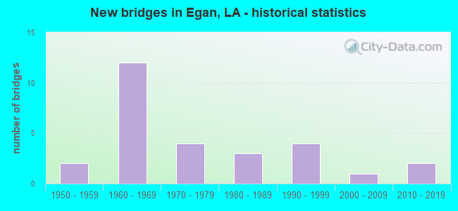
- New bridges - historical statistics
- 21950-1959
- 121960-1969
- 41970-1979
- 31980-1989
- 41990-1999
- 12000-2009
- 22010-2019
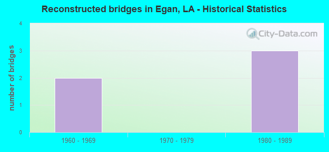
- Reconstructed bridges - Historical Statistics
- 21960-1969
- 01970-1979
- 31980-1989
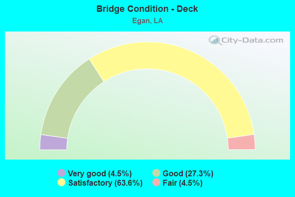
- Bridge Condition - Deck
- 4.5%Very good
- 27.3%Good
- 63.6%Satisfactory
- 4.5%Fair
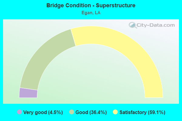
- Bridge Condition - Superstructure
- 4.5%Very good
- 36.4%Good
- 59.1%Satisfactory
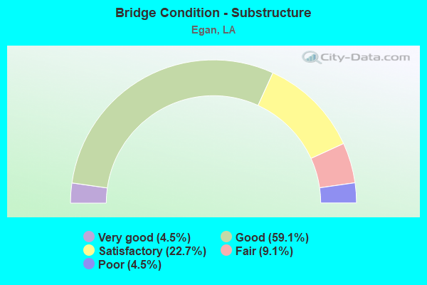
- Bridge Condition - Substructure
- 4.5%Very good
- 59.1%Good
- 22.7%Satisfactory
- 9.1%Fair
- 4.5%Poor
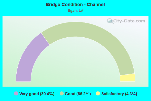
- Bridge Condition - Channel
- 30.4%Very good
- 65.2%Good
- 4.3%Satisfactory
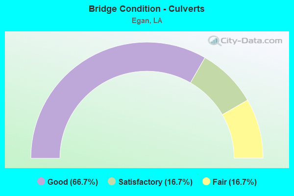
- Bridge Condition - Culverts
- 66.7%Good
- 16.7%Satisfactory
- 16.7%Fair
Find on map >> Show street view
Structure Number: 30100000030477, Location: 0.87 MI W OF LA 91 (Lat: 30.290331, Lng: -92.514261), Route carried "on" structure: County highway , Year Built: 2016, Status: Posted for load, Structure Length: 2.62m (8.60ft), Average Daily Traffic: 192 (year 2020), Average Future Daily Traffic: 211 (year 2040), Features Intersected: POINTE AUX LOUPS BAYOU, Facility Carried by Structure: CONNIE RD
Minimum Vertical Clearance: 30+ m (98+ ft), Kilometerpoint: 1.046, Lanes on structure: 2, Owner: County Highway Agency, Approaching Roadway Width: 7.0m (23.0ft), Material/Design: Wood or Timber, Design/Construction: Stringer/Multi-beam, Number Of Spans In Main Unit: 5, Length of Maximum Span: 5.8m (19.0ft), Curb-To-Curb Width: 7.1m (23.3ft), Out-to-Out Width: 7.5m (24.6ft)
Condition: Deck: Good, Superstructure: Good, Substructure: Good, Channel: Good, Operating Rating: 20.0 metric tons, Method Used To Determine Operating Rating: Allowable Stress (AS), Inventory Rating: 14.5 metric tons, Method Used To Determine Inventory Rating: Allowable Stress (AS), Structural Evaluation: Meets minimum limits, Deck Geometry: Meets minimum limits, Waterway Adequacy: Better than present minimum criteria, Approach Roadway Alignment: Equal to present desirable criteria, Bridge Posting: Required (Relationship of Operating Rating to Maximum Legal Load: 10.0 - 19.9% below), Designated Inspection Frequency: Every 24 months, Inspection Date: July 2020, Deck Structure Type: Wood or Timber, Wearing Surface/Protective System: Wearing Surface: Wood or Timber
Find on map >> Show street view
Structure Number: 30100000030509, Location: 1.0 MI N. of I-10 (Lat: 30.248631, Lng: -92.464250), Route carried "on" structure: State highway 1120, Year Built: 2017, Status: Open, Structure Length: 2.44m (8.01ft), Average Daily Traffic: 1,150 (year 2016), Truck Traffic: 12%, Average Future Daily Traffic: 900 (year 2035), Features Intersected: Desaul Canal
Minimum Vertical Clearance: 30+ m (98+ ft), Kilometerpoint: 1.352, Lanes on structure: 2, Owner: State Highway Agency, Approaching Roadway Width: 6.4m (21.0ft), Material/Design: Concrete, Design/Construction: Slab, Number Of Spans In Main Unit: 4, Length of Maximum Span: 6.1m (20.0ft), Curb-To-Curb Width: 9.8m (32.2ft), Out-to-Out Width: 10.7m (35.1ft)
Condition: Deck: Very good, Superstructure: Very good, Substructure: Very good, Channel: Good, Operating Rating: 71.3 metric tons, Method Used To Determine Operating Rating: Load and Resistance Factor Rating (LRFR) rating reported by rating factor(RF) method using HL-93 loadings, Inventory Rating: 55.1 metric tons, Method Used To Determine Inventory Rating: Load and Resistance Factor Rating (LRFR) rating reported by rating factor(RF) method using HL-93 loadings, Structural Evaluation: Equal to present desirable criteria, Deck Geometry: Somewhat better than minimum adequacy, Waterway Adequacy: Equal to present desirable criteria, Approach Roadway Alignment: Equal to present desirable criteria, Designated Inspection Frequency: Every 24 months, Inspection Date: November 2021, Deck Structure Type: Concrete Precast Panels
Find on map >> Show street view
Structure Number: 30102110106361, Location: 1.66 MI W of LA 1120 (Lat: 30.236561, Lng: -92.491900), Route carried "on" structure: State highway 91, Year Built: 1979, Status: Open, Structure Length: 3.47m (11.38ft), Average Daily Traffic: 2,048 (year 2019), Truck Traffic: 13%, Average Future Daily Traffic: 2,253 (year 2039), Design Load: HS 20, Features Intersected: BAYOU JONAS
Minimum Vertical Clearance: 30+ m (98+ ft), Kilometerpoint: 10.205, Lanes on structure: 2, Owner: State Highway Agency, Approaching Roadway Width: 9.8m (32.2ft), Material/Design: Concrete, Design/Construction: Slab, Number Of Spans In Main Unit: 6, Length of Maximum Span: 5.8m (19.0ft), Curb-To-Curb Width: 12.3m (40.4ft), Out-to-Out Width: 13.2m (43.3ft)
Condition: Deck: Satisfactory, Superstructure: Satisfactory, Substructure: Poor, Channel: Good, Operating Rating: 61.7 metric tons, Method Used To Determine Operating Rating: Load Factor (LF), Inventory Rating: 37.2 metric tons, Method Used To Determine Inventory Rating: Load Factor (LF), Structural Evaluation: Meets minimum limits, Deck Geometry: Equal to present minimum criteria, Waterway Adequacy: Equal to present desirable criteria, Approach Roadway Alignment: Equal to present desirable criteria, Designated Inspection Frequency: Every 24 months, Other Special Inspection Frequency: Every 12 months, Inspection Date: March 2021, Deck Structure Type: Concrete Precast Panels, Wearing Surface/Protective System: Wearing Surface: Bituminous
Find on map >> Show street view
Structure Number: 30102113001211, Location: 1.21 MI EAST OF LA 97 (Lat: 30.266150, Lng: -92.565500), Route carried "on" structure: State highway 100, Year Built: 1951, Status: Open, Structure Length: 3.72m (12.20ft), Average Daily Traffic: 1,410 (year 2016), Truck Traffic: 12%, Average Future Daily Traffic: 702 (year 2036), Design Load: H 15, Features Intersected: CREEK
Minimum Vertical Clearance: 30+ m (98+ ft), Kilometerpoint: 1.914, Lanes on structure: 2, Owner: State Highway Agency, Approaching Roadway Width: 9.8m (32.2ft), Material/Design: Steel, Design/Construction: Stringer/Multi-beam, Number Of Spans In Main Unit: 3, Length of Maximum Span: 12.2m (40.0ft), Curb-To-Curb Width: 7.3m (24.0ft), Out-to-Out Width: 8.9m (29.2ft)
Condition: Deck: Satisfactory, Superstructure: Satisfactory, Substructure: Good, Channel: Very good, Operating Rating: 36.3 metric tons, Method Used To Determine Operating Rating: Load Factor (LF), Inventory Rating: 20.9 metric tons, Method Used To Determine Inventory Rating: Load Factor (LF), Structural Evaluation: Somewhat better than minimum adequacy, Deck Geometry: Meets minimum limits, Waterway Adequacy: Equal to present desirable criteria, Approach Roadway Alignment: Equal to present desirable criteria, Designated Inspection Frequency: Every 24 months, Inspection Date: Febuary 2022, Deck Structure Type: Concrete Cast-file-Place
Find on map >> Show street view
Structure Number: 30102113001711, Location: 1.71 MI EAST OF LA 97 (Lat: 30.268069, Lng: -92.560400), Route carried "on" structure: State highway 100, Year Built: 1951, Status: Open, Structure Length: 28.13m (92.29ft), Average Daily Traffic: 1,410 (year 2016), Truck Traffic: 12%, Average Future Daily Traffic: 702 (year 2036), Design Load: H 15, Features Intersected: B DES CANNES EVNG
Minimum Vertical Clearance: 30+ m (98+ ft), Kilometerpoint: 2.448, Lanes on structure: 2, Owner: State Highway Agency, Approaching Roadway Width: 9.8m (32.2ft), Material/Design: Steel, Design/Construction: Stringer/Multi-beam, Number Of Spans In Main Unit: 23, Length of Maximum Span: 15.2m (49.9ft), Curb-To-Curb Width: 7.3m (24.0ft), Out-to-Out Width: 8.9m (29.2ft)
Condition: Deck: Satisfactory, Superstructure: Satisfactory, Substructure: Satisfactory, Channel: Good, Operating Rating: 36.3 metric tons, Method Used To Determine Operating Rating: Load Factor (LF), Inventory Rating: 21.8 metric tons, Method Used To Determine Inventory Rating: Load Factor (LF), Structural Evaluation: Somewhat better than minimum adequacy, Deck Geometry: Meets minimum limits, Waterway Adequacy: Better than present minimum criteria, Approach Roadway Alignment: Equal to present desirable criteria, Designated Inspection Frequency: Every 24 months, Underwater Inspection Frequency: Every 60 months, Inspection Date: May 2020, Underwater Inspection Date: October 2018, Deck Structure Type: Concrete Cast-file-Place
Find on map >> Show street view
Structure Number: 30102113003321, Location: 3.32 MI. EAST OF LA. 97 (Lat: 30.270519, Lng: -92.531000), Route carried "on" structure: State highway 100, Year Built: 1997, Status: Open, Structure Length: 3.66m (12.01ft), Average Daily Traffic: 1,410 (year 2016), Truck Traffic: 12%, Average Future Daily Traffic: 702 (year 2036), Design Load: HS 20, Features Intersected: BAYOU POINTE AUX LOUPS
Minimum Vertical Clearance: 30+ m (98+ ft), Kilometerpoint: 5.320, Lanes on structure: 2, Owner: State Highway Agency, Approaching Roadway Width: 8.5m (27.9ft), Material/Design: Concrete, Design/Construction: Slab, Number Of Spans In Main Unit: 6, Length of Maximum Span: 6.1m (20.0ft), Curb-To-Curb Width: 12.2m (40.0ft), Out-to-Out Width: 13.0m (42.7ft)
Condition: Deck: Good, Superstructure: Good, Substructure: Good, Channel: Very good, Operating Rating: 78.0 metric tons, Method Used To Determine Operating Rating: Load Factor (LF), Inventory Rating: 46.3 metric tons, Method Used To Determine Inventory Rating: Load Factor (LF), Structural Evaluation: Better than present minimum criteria, Deck Geometry: Better than present minimum criteria, Waterway Adequacy: Equal to present desirable criteria, Approach Roadway Alignment: Equal to present minimum criteria, Designated Inspection Frequency: Every 24 months, Inspection Date: Febuary 2022, Deck Structure Type: Concrete Cast-file-Place, Wearing Surface/Protective System: Wearing Surface: Monolithic Concrete
Find on map >> Show street view
Structure Number: 30102113004461, Location: 0.86 MI W of LA 91 (Lat: 30.267939, Lng: -92.512600), Route carried "on" structure: State highway 100, Year Built: 1997, Status: Open, Structure Length: 1.28m (4.20ft), Average Daily Traffic: 1,410 (year 2016), Truck Traffic: 12%, Average Future Daily Traffic: 702 (year 2036), Design Load: HS 20, Features Intersected: DRAINAGE CANAL
Minimum Vertical Clearance: 30+ m (98+ ft), Kilometerpoint: 7.176, Lanes on structure: 2, Owner: State Highway Agency, Approaching Roadway Width: 8.5m (27.9ft), Skew: 4 degrees, Material/Design: Steel, Design/Construction: Culvert, Number Of Spans In Main Unit: 3, Length of Maximum Span: 2.4m (7.9ft)
Condition: Channel: Good, Culverts: Good, Operating Rating: 97.2 metric tons, Method Used To Determine Operating Rating: Load and Resistance Factor Rating (LRFR) rating reported by rating factor(RF) method using HL-93 loadings, Inventory Rating: 74.5 metric tons, Method Used To Determine Inventory Rating: Load and Resistance Factor Rating (LRFR) rating reported by rating factor(RF) method using HL-93 loadings, Structural Evaluation: Better than present minimum criteria, Waterway Adequacy: Equal to present desirable criteria, Approach Roadway Alignment: Equal to present desirable criteria, Designated Inspection Frequency: Every 24 months, Inspection Date: March 2020
Find on map >> Show street view
Structure Number: 30104500403391, Location: 3.8 MI EAST OF LA 97 (Lat: 30.236161, Lng: -92.568500), Route carried "on" structure: Interstate 10, Year Built: 1992, Status: Open, Structure Length: 12.25m (40.19ft), Average Daily Traffic: 49,800 (year 2016), Truck Traffic: 22%, Average Future Daily Traffic: 27,600 (year 2036), Design Load: HS 20, Features Intersected: DES CANNES RELIEF
Minimum Vertical Clearance: 30+ m (98+ ft), Kilometerpoint: 5.464, Lanes on structure: 2, Base Highway Network: Yes (Inventory Route: 450-04-1, Subroute: 10), Owner: State Highway Agency, Approaching Roadway Width: 11.6m (38.1ft), Material/Design: Steel, Design/Construction: Stringer/Multi-beam, Number Of Spans In Main Unit: 10, Length of Maximum Span: 12.2m (40.0ft), Curb-To-Curb Width: 12.2m (40.0ft), Out-to-Out Width: 13.0m (42.7ft)
Condition: Deck: Satisfactory, Superstructure: Satisfactory, Substructure: Good, Channel: Good, Operating Rating: 68.9 metric tons, Method Used To Determine Operating Rating: Load Factor (LF), Inventory Rating: 41.7 metric tons, Method Used To Determine Inventory Rating: Load Factor (LF), Structural Evaluation: Equal to present minimum criteria, Deck Geometry: Somewhat better than minimum adequacy, Waterway Adequacy: Better than present minimum criteria, Approach Roadway Alignment: Equal to present desirable criteria, Designated Inspection Frequency: Every 24 months, Inspection Date: March 2021, Deck Structure Type: Concrete Cast-file-Place
Find on map >> Show street view
Structure Number: 30104500403392, Location: 6.30 Mi W of LA 91 (Lat: 30.236369, Lng: -92.567300), Route carried "on" structure: Interstate 10, Year Built: 1961, Year Reconstructed: 1992, Status: Open, Structure Length: 12.25m (40.19ft), Average Daily Traffic: 24,900 (year 2016), Truck Traffic: 22%, Average Future Daily Traffic: 16,560 (year 2036), Design Load: HS 20, Features Intersected: DES CANNES RELIEF
Minimum Vertical Clearance: 30+ m (98+ ft), Kilometerpoint: 38.077, Lanes on structure: 2, Base Highway Network: Yes (Inventory Route: 450-04-2, Subroute: 10), Owner: State Highway Agency, Approaching Roadway Width: 11.6m (38.1ft), Skew: 10 degrees, Material/Design: Steel, Design/Construction: Stringer/Multi-beam, Number Of Spans In Main Unit: 10, Length of Maximum Span: 12.2m (40.0ft), Curb-To-Curb Width: 12.2m (40.0ft), Out-to-Out Width: 13.0m (42.7ft)
Condition: Deck: Satisfactory, Superstructure: Satisfactory, Substructure: Good, Channel: Very good, Operating Rating: 68.9 metric tons, Method Used To Determine Operating Rating: Load Factor (LF), Inventory Rating: 41.7 metric tons, Method Used To Determine Inventory Rating: Load Factor (LF), Structural Evaluation: Equal to present minimum criteria, Deck Geometry: Better than present minimum criteria, Waterway Adequacy: Equal to present desirable criteria, Approach Roadway Alignment: Equal to present desirable criteria, Designated Inspection Frequency: Every 24 months, Inspection Date: March 2021, Deck Structure Type: Concrete Cast-file-Place
Find on map >> Show street view
Structure Number: 30104500403681, Location: 4.1 MI EAST OF LA 97 (Lat: 30.236139, Lng: -92.563700), Route carried "on" structure: Interstate 10, Year Built: 1961, Year Reconstructed: 1992, Status: Open, Structure Length: 12.25m (40.19ft), Average Daily Traffic: 24,900 (year 2016), Truck Traffic: 22%, Average Future Daily Traffic: 16,560 (year 2036), Design Load: HS 20, Features Intersected: BAYOU DES CANNES
Minimum Vertical Clearance: 30+ m (98+ ft), Kilometerpoint: 5.930, Lanes on structure: 2, Base Highway Network: Yes (Inventory Route: 450-04-1, Subroute: 10), Owner: State Highway Agency, Approaching Roadway Width: 11.6m (38.1ft), Skew: 10 degrees, Material/Design: Steel, Design/Construction: Stringer/Multi-beam, Number Of Spans In Main Unit: 10, Length of Maximum Span: 12.2m (40.0ft), Curb-To-Curb Width: 12.2m (40.0ft), Out-to-Out Width: 13.0m (42.7ft)
Condition: Deck: Satisfactory, Superstructure: Satisfactory, Substructure: Good, Channel: Good, Operating Rating: 68.9 metric tons, Method Used To Determine Operating Rating: Load Factor (LF), Inventory Rating: 41.7 metric tons, Method Used To Determine Inventory Rating: Load Factor (LF), Structural Evaluation: Equal to present minimum criteria, Deck Geometry: Better than present minimum criteria, Waterway Adequacy: Equal to present desirable criteria, Approach Roadway Alignment: Equal to present desirable criteria, Designated Inspection Frequency: Every 24 months, Underwater Inspection Frequency: Every 60 months, Inspection Date: March 2021, Underwater Inspection Date: October 2018, Deck Structure Type: Concrete Cast-file-Place
Find on map >> Show street view
Structure Number: 30104500403682, Location: 6.01 MI W of LA 91 (Lat: 30.236361, Lng: -92.562400), Route carried "on" structure: Interstate 10, Year Built: 1961, Year Reconstructed: 1992, Status: Open, Structure Length: 12.25m (40.19ft), Average Daily Traffic: 24,900 (year 2016), Truck Traffic: 22%, Average Future Daily Traffic: 27,340 (year 2036), Design Load: HS 20, Features Intersected: BAYOU DES CANNES
Minimum Vertical Clearance: 30+ m (98+ ft), Kilometerpoint: 37.612, Lanes on structure: 2, Base Highway Network: Yes (Inventory Route: 450-04-2, Subroute: 10), Owner: State Highway Agency, Approaching Roadway Width: 11.6m (38.1ft), Skew: 10 degrees, Material/Design: Steel, Design/Construction: Stringer/Multi-beam, Number Of Spans In Main Unit: 10, Length of Maximum Span: 12.2m (40.0ft), Curb-To-Curb Width: 12.2m (40.0ft), Out-to-Out Width: 13.0m (42.7ft)
Condition: Deck: Good, Superstructure: Good, Substructure: Good, Channel: Good, Operating Rating: 68.9 metric tons, Method Used To Determine Operating Rating: Load Factor (LF), Inventory Rating: 41.7 metric tons, Method Used To Determine Inventory Rating: Load Factor (LF), Structural Evaluation: Better than present minimum criteria, Deck Geometry: Better than present minimum criteria, Waterway Adequacy: Equal to present desirable criteria, Approach Roadway Alignment: Equal to present desirable criteria, Designated Inspection Frequency: Every 24 months, Underwater Inspection Frequency: Every 60 months, Inspection Date: March 2021, Underwater Inspection Date: October 2018, Deck Structure Type: Concrete Cast-file-Place
Find on map >> Show street view
Structure Number: 30104500405561, Location: 6.0 MI EAST OF LA 97 (Lat: 30.231731, Lng: -92.532800), Route carried "on" structure: Interstate 10, Year Built: 1961, Status: Open, Structure Length: 0.85m (2.79ft), Average Daily Traffic: 49,800 (year 2016), Truck Traffic: 22%, Average Future Daily Traffic: 27,600 (year 2036), Design Load: HS 20, Features Intersected: DRAIN
Minimum Vertical Clearance: 30+ m (98+ ft), Kilometerpoint: 8.954, Lanes on structure: 8, Base Highway Network: Yes (Inventory Route: 450-04-1, Subroute: 10), Owner: State Highway Agency, Approaching Roadway Width: 41.8m (137.1ft), Skew: 10 degrees, Material/Design: Concrete, Design/Construction: Culvert, Number Of Spans In Main Unit: 5, Length of Maximum Span: 1.5m (4.9ft), Curb-To-Curb Width: 41.8m (137.1ft), Out-to-Out Width: 141.7m (464.9ft)
Condition: Channel: Very good, Culverts: Good, Operating Rating: 42.1 metric tons, Method Used To Determine Operating Rating: Load and Resistance Factor Rating (LRFR) rating reported by rating factor(RF) method using HL-93 loadings, Inventory Rating: 32.4 metric tons, Method Used To Determine Inventory Rating: Load and Resistance Factor Rating (LRFR) rating reported by rating factor(RF) method using HL-93 loadings, Structural Evaluation: Better than present minimum criteria, Deck Geometry: Superior to present desirable criteria, Waterway Adequacy: Equal to present desirable criteria, Approach Roadway Alignment: Equal to present desirable criteria, Designated Inspection Frequency: Every 24 months, Inspection Date: Febuary 2021, Deck Structure Type: Concrete Cast-file-Place
Find on map >> Show street view
Structure Number: 30104500405681, Location: 6.1 MI EAST OF LA 97 (Lat: 30.231461, Lng: -92.530800), Route carried "on" structure: County highway , Year Built: 1961, Status: Open, Structure Length: 7.68m (25.20ft), Average Daily Traffic: 4,600 (year 2015), Average Future Daily Traffic: 2,760 (year 2036), Design Load: HS 20, Features Intersected: I0010, Facility Carried by Structure: Trumps Rd
Minimum Vertical Clearance: 30+ m (98+ ft), Kilometerpoint: 9.151, Lanes on structure: 2, Lanes under structure: 4, Base Highway Network: Yes (Inventory Route: 450-04-1, Subroute: 10), Owner: State Highway Agency, Approaching Roadway Width: 12.2m (40.0ft), Skew: 3 degrees, Material/Design: Steel, Design/Construction: Stringer/Multi-beam, Number Of Spans In Main Unit: 4, Length of Maximum Span: 24.4m (80.1ft), Curb-To-Curb Width: 8.6m (28.2ft), Out-to-Out Width: 10.3m (33.8ft)
Condition: Deck: Fair, Superstructure: Good, Substructure: Good, Operating Rating: 59.0 metric tons, Method Used To Determine Operating Rating: Load Factor (LF), Inventory Rating: 35.4 metric tons, Method Used To Determine Inventory Rating: Load Factor (LF), Structural Evaluation: Better than present minimum criteria, Deck Geometry: Meets minimum limits, Underclear: Meets minimum limits, Approach Roadway Alignment: Equal to present desirable criteria, Designated Inspection Frequency: Every 24 months, Inspection Date: August 2020, Deck Structure Type: Concrete Cast-file-Place
Find on map >> Show street view
Structure Number: 30104500407051, Location: 7.5 MI EAST OF LA 97 (Lat: 30.231181, Lng: -92.507500), Route carried "on" structure: Interstate 10, Year Built: 1961, Year Reconstructed: 1973, Status: Open, Structure Length: 8.60m (28.22ft), Average Daily Traffic: 17,650 (year 2016), Truck Traffic: 22%, Average Future Daily Traffic: 12,600 (year 2036), Design Load: HS 20, Features Intersected: Plant Rd
Minimum Vertical Clearance: 30+ m (98+ ft), Kilometerpoint: 11.389, Lanes on structure: 2, Lanes under structure: 2, Base Highway Network: Yes (Inventory Route: 450-04-1, Subroute: 10), Owner: State Highway Agency, Approaching Roadway Width: 12.8m (42.0ft), Skew: 10 degrees, Material/Design: Steel, Design/Construction: Stringer/Multi-beam, Number Of Spans In Main Unit: 5, Length of Maximum Span: 18.3m (60.0ft), Curb-To-Curb Width: 11.3m (37.1ft), Out-to-Out Width: 12.4m (40.7ft)
Condition: Deck: Satisfactory, Superstructure: Satisfactory, Substructure: Good, Operating Rating: 59.9 metric tons, Method Used To Determine Operating Rating: Load Factor (LF), Inventory Rating: 36.3 metric tons, Method Used To Determine Inventory Rating: Load Factor (LF), Structural Evaluation: Equal to present minimum criteria, Deck Geometry: Somewhat better than minimum adequacy, Underclear: Superior to present desirable criteria, Approach Roadway Alignment: Equal to present desirable criteria, Designated Inspection Frequency: Every 24 months, Inspection Date: Febuary 2022, Deck Structure Type: Concrete Cast-file-Place
Find on map >> Show street view
Structure Number: 30104500407052, Location: 7.30 Mi W of LA 13 (Lat: 30.231381, Lng: -92.506600), Route carried "on" structure: Interstate 10, Year Built: 1961, Year Reconstructed: 1973, Status: Open, Structure Length: 8.60m (28.22ft), Average Daily Traffic: 17,650 (year 2016), Truck Traffic: 22%, Average Future Daily Traffic: 12,600 (year 2036), Design Load: HS 20, Features Intersected: Plant Rd
Minimum Vertical Clearance: 30+ m (98+ ft), Kilometerpoint: 32.188, Lanes on structure: 2, Lanes under structure: 2, Base Highway Network: Yes (Inventory Route: 450-04-2, Subroute: 10), Owner: State Highway Agency, Approaching Roadway Width: 13.4m (44.0ft), Skew: 10 degrees, Material/Design: Steel, Design/Construction: Stringer/Multi-beam, Number Of Spans In Main Unit: 5, Length of Maximum Span: 18.3m (60.0ft), Curb-To-Curb Width: 11.3m (37.1ft), Out-to-Out Width: 12.4m (40.7ft)
Condition: Deck: Satisfactory, Superstructure: Satisfactory, Substructure: Good, Operating Rating: 57.1 metric tons, Method Used To Determine Operating Rating: Load Factor (LF), Inventory Rating: 34.5 metric tons, Method Used To Determine Inventory Rating: Load Factor (LF), Structural Evaluation: Equal to present minimum criteria, Deck Geometry: Somewhat better than minimum adequacy, Underclear: Superior to present desirable criteria, Approach Roadway Alignment: Equal to present desirable criteria, Designated Inspection Frequency: Every 24 months, Inspection Date: Febuary 2022, Deck Structure Type: Concrete Cast-file-Place
Find on map >> Show street view
Structure Number: 30104500407811, Location: 8.3 MI EAST OF LA 97 (Lat: 30.230919, Lng: -92.494800), Route carried "on" structure: Interstate 10, Year Built: 1961, Status: Open, Structure Length: 6.16m (20.21ft), Average Daily Traffic: 17,650 (year 2016), Truck Traffic: 22%, Average Future Daily Traffic: 12,600 (year 2036), Design Load: HS 20, Features Intersected: BAYOU JONAS
Minimum Vertical Clearance: 30+ m (98+ ft), Kilometerpoint: 12.614, Lanes on structure: 2, Base Highway Network: Yes (Inventory Route: 450-04-1, Subroute: 10), Owner: State Highway Agency, Approaching Roadway Width: 12.2m (40.0ft), Skew: 10 degrees, Material/Design: Concrete, Design/Construction: Slab, Number Of Spans In Main Unit: 10, Length of Maximum Span: 6.1m (20.0ft), Curb-To-Curb Width: 8.6m (28.2ft), Out-to-Out Width: 10.2m (33.5ft)
Condition: Deck: Satisfactory, Superstructure: Satisfactory, Substructure: Satisfactory, Channel: Good, Operating Rating: 53.5 metric tons, Method Used To Determine Operating Rating: Load Factor (LF), Inventory Rating: 32.7 metric tons, Method Used To Determine Inventory Rating: Load Factor (LF), Structural Evaluation: Equal to present minimum criteria, Deck Geometry: High priority of corrective action, Waterway Adequacy: Equal to present desirable criteria, Approach Roadway Alignment: Equal to present desirable criteria, Length Of Structure Improvement: 7.07m (23.20ft), Designated Inspection Frequency: Every 24 months, Inspection Date: Febuary 2021, Bridge Improvement Cost: $603,000, Total Project Cost: $904,000 ( Estimate for 2016), Deck Structure Type: Concrete Cast-file-Place
Find on map >> Show street view
Structure Number: 30104500407812, Location: 1.86 Mi W of LA 91 (Lat: 30.231131, Lng: -92.494200), Route carried "on" structure: Interstate 10, Year Built: 1961, Status: Open, Structure Length: 6.16m (20.21ft), Average Daily Traffic: 17,650 (year 2016), Truck Traffic: 22%, Average Future Daily Traffic: 12,600 (year 2036), Design Load: HS 20, Features Intersected: BAYOU JONAS
Minimum Vertical Clearance: 30+ m (98+ ft), Kilometerpoint: 30.991, Lanes on structure: 2, Base Highway Network: Yes (Inventory Route: 450-04-2, Subroute: 10), Owner: State Highway Agency, Approaching Roadway Width: 12.2m (40.0ft), Skew: 10 degrees, Material/Design: Concrete, Design/Construction: Slab, Number Of Spans In Main Unit: 10, Length of Maximum Span: 6.1m (20.0ft), Curb-To-Curb Width: 8.6m (28.2ft), Out-to-Out Width: 10.2m (33.5ft)
Condition: Deck: Satisfactory, Superstructure: Satisfactory, Substructure: Satisfactory, Channel: Good, Operating Rating: 53.5 metric tons, Method Used To Determine Operating Rating: Load Factor (LF), Inventory Rating: 32.7 metric tons, Method Used To Determine Inventory Rating: Load Factor (LF), Structural Evaluation: Equal to present minimum criteria, Deck Geometry: High priority of corrective action, Waterway Adequacy: Equal to present desirable criteria, Approach Roadway Alignment: Equal to present desirable criteria, Length Of Structure Improvement: 7.07m (23.20ft), Designated Inspection Frequency: Every 24 months, Inspection Date: Febuary 2021, Bridge Improvement Cost: $603,000, Total Project Cost: $904,000 ( Estimate for 2016), Deck Structure Type: Concrete Cast-file-Place
Find on map >> Show street view
Structure Number: 30104500408111, Location: 8.6 MI EAST OF LA 97 (Lat: 30.230631, Lng: -92.489800), Route carried "on" structure: County highway , Year Built: 1961, Status: Open, Structure Length: 6.77m (22.21ft), Average Daily Traffic: 3,500 (year 2015), Average Future Daily Traffic: 2,100 (year 2036), Design Load: HS 20, Features Intersected: INTERSTATE 10, Facility Carried by Structure: Sensat Cove Rd
Minimum Vertical Clearance: 30+ m (98+ ft), Kilometerpoint: 13.089, Lanes on structure: 2, Lanes under structure: 4, Base Highway Network: Yes (Inventory Route: 450-04-1, Subroute: 10), Owner: State Highway Agency, Approaching Roadway Width: 11.0m (36.1ft), Material/Design: Steel, Design/Construction: Stringer/Multi-beam, Number Of Spans In Main Unit: 4, Length of Maximum Span: 21.3m (69.9ft), Curb-To-Curb Width: 7.3m (24.0ft), Out-to-Out Width: 9.1m (29.9ft)
Condition: Deck: Satisfactory, Superstructure: Good, Substructure: Good, Operating Rating: 37.2 metric tons, Method Used To Determine Operating Rating: Load Factor (LF), Inventory Rating: 20.0 metric tons, Method Used To Determine Inventory Rating: Load Factor (LF), Structural Evaluation: Somewhat better than minimum adequacy, Deck Geometry: High priority of replacement, Underclear: High priority of replacement, Approach Roadway Alignment: Equal to present desirable criteria, Length Of Structure Improvement: 7.68m (25.20ft), Designated Inspection Frequency: Every 24 months, Inspection Date: August 2020, Bridge Improvement Cost: $655,000, Total Project Cost: $982,000 ( Estimate for 2016), Deck Structure Type: Concrete Cast-file-Place
Find on map >> Show street view
Structure Number: 30108010903341, Location: 0.4 MI S of I-10 (Lat: 30.227261, Lng: -92.464100), Route carried "on" structure: State highway 91, Year Built: 1964, Status: Open, Structure Length: 0.82m (2.69ft), Average Daily Traffic: 3,464 (year 2019), Truck Traffic: 13%, Average Future Daily Traffic: 3,810 (year 2039), Design Load: HS 20, Features Intersected: CREEK
Minimum Vertical Clearance: 30+ m (98+ ft), Kilometerpoint: 5.436, Lanes on structure: 2, Owner: State Highway Agency, Approaching Roadway Width: 6.1m (20.0ft), Skew: 3 degrees, Material/Design: Steel, Design/Construction: Culvert, Number Of Spans In Main Unit: 3, Length of Maximum Span: 1.8m (5.9ft), Out-to-Out Width: 19.2m (63.0ft)
Condition: Channel: Very good, Culverts: Fair, Operating Rating: 97.2 metric tons, Method Used To Determine Operating Rating: Load and Resistance Factor Rating (LRFR) rating reported by rating factor(RF) method using HL-93 loadings, Inventory Rating: 74.5 metric tons, Method Used To Determine Inventory Rating: Load and Resistance Factor Rating (LRFR) rating reported by rating factor(RF) method using HL-93 loadings, Structural Evaluation: Somewhat better than minimum adequacy, Waterway Adequacy: Equal to present desirable criteria, Approach Roadway Alignment: Equal to present desirable criteria, Designated Inspection Frequency: Every 24 months, Inspection Date: December 2021
Find on map >> Show street view
Structure Number: 30108010903771, Location: 3.77 MI NORTH OF US 90 (Lat: 30.233389, Lng: -92.464100), Route carried "on" structure: State highway 91, Year Built: 1960, Status: Open, Structure Length: 7.38m (24.21ft), Average Daily Traffic: 3,000 (year 2016), Truck Traffic: 13%, Average Future Daily Traffic: 1,500 (year 2036), Design Load: HS 20, Features Intersected: I0010
Minimum Vertical Clearance: 30+ m (98+ ft), Kilometerpoint: 6.116, Lanes on structure: 2, Lanes under structure: 4, Owner: State Highway Agency, Approaching Roadway Width: 10.7m (35.1ft), Skew: 1 degrees, Material/Design: Steel, Design/Construction: Stringer/Multi-beam, Number Of Spans In Main Unit: 4, Length of Maximum Span: 22.9m (75.1ft), Curb-To-Curb Width: 8.5m (27.9ft), Out-to-Out Width: 10.2m (33.5ft)
Condition: Deck: Satisfactory, Superstructure: Satisfactory, Substructure: Satisfactory, Operating Rating: 54.4 metric tons, Method Used To Determine Operating Rating: Load Factor (LF), Inventory Rating: 32.7 metric tons, Method Used To Determine Inventory Rating: Load Factor (LF), Structural Evaluation: Equal to present minimum criteria, Deck Geometry: Meets minimum limits, Underclear: Somewhat better than minimum adequacy, Approach Roadway Alignment: Equal to present desirable criteria, Designated Inspection Frequency: Every 24 months, Inspection Date: September 2020, Deck Structure Type: Concrete Cast-file-Place
Find on map >> Show street view
Structure Number: 30108011001811, Location: 1.81 MI NORTH OF LA 91 (Lat: 30.262731, Lng: -92.464300), Route carried "on" structure: State highway 1120, Year Built: 1974, Status: Open, Structure Length: 1.13m (3.71ft), Average Daily Traffic: 1,150 (year 2016), Truck Traffic: 12%, Average Future Daily Traffic: 1,265 (year 2036), Design Load: HS 20, Features Intersected: CANAL
Minimum Vertical Clearance: 30+ m (98+ ft), Kilometerpoint: 2.910, Lanes on structure: 2, Owner: State Highway Agency, Approaching Roadway Width: 9.4m (30.8ft), Skew: 4 degrees, Material/Design: Concrete, Design/Construction: Culvert, Number Of Spans In Main Unit: 3, Length of Maximum Span: 3.4m (11.2ft), Out-to-Out Width: 12.3m (40.4ft)
Condition: Channel: Good, Culverts: Good, Operating Rating: 42.1 metric tons, Method Used To Determine Operating Rating: Load and Resistance Factor Rating (LRFR) rating reported by rating factor(RF) method using HL-93 loadings, Inventory Rating: 32.4 metric tons, Method Used To Determine Inventory Rating: Load and Resistance Factor Rating (LRFR) rating reported by rating factor(RF) method using HL-93 loadings, Structural Evaluation: Better than present minimum criteria, Waterway Adequacy: Better than present minimum criteria, Approach Roadway Alignment: Equal to present desirable criteria, Designated Inspection Frequency: Every 24 months, Inspection Date: December 2021, Deck Structure Type: Concrete Cast-file-Place
Find on map >> Show street view
Structure Number: 30108011002871, Location: 2.5 Miles N. of I-10 (Lat: 30.275039, Lng: -92.467900), Route carried "on" structure: State highway 1120, Year Built: 1974, Status: Open, Structure Length: 1.74m (5.71ft), Average Daily Traffic: 791 (year 2020), Truck Traffic: 12%, Average Future Daily Traffic: 870 (year 2040), Design Load: HS 20, Features Intersected: ANDRE CANAL
Minimum Vertical Clearance: 30+ m (98+ ft), Kilometerpoint: 4.601, Lanes on structure: 2, Owner: State Highway Agency, Approaching Roadway Width: 6.7m (22.0ft), Material/Design: Concrete, Design/Construction: Slab, Number Of Spans In Main Unit: 3, Length of Maximum Span: 5.8m (19.0ft), Curb-To-Curb Width: 8.6m (28.2ft), Out-to-Out Width: 9.4m (30.8ft)
Condition: Deck: Satisfactory, Superstructure: Satisfactory, Substructure: Fair, Channel: Good, Operating Rating: 24.0 metric tons, Method Used To Determine Operating Rating: Load and Resistance Factor Rating (LRFR) rating reported by rating factor(RF) method using HL-93 loadings, Inventory Rating: 18.5 metric tons, Method Used To Determine Inventory Rating: Load and Resistance Factor Rating (LRFR) rating reported by rating factor(RF) method using HL-93 loadings, Structural Evaluation: Somewhat better than minimum adequacy, Deck Geometry: Somewhat better than minimum adequacy, Waterway Adequacy: Equal to present desirable criteria, Approach Roadway Alignment: Equal to present desirable criteria, Designated Inspection Frequency: Every 24 months, Inspection Date: Febuary 2021, Deck Structure Type: Concrete Precast Panels, Wearing Surface/Protective System: Wearing Surface: Bituminous
Find on map >> Show street view
Structure Number: 30108011003611, Location: 3.8 MI N of I-10 (Lat: 30.281689, Lng: -92.472900), Route carried "on" structure: State highway 1120, Year Built: 1974, Status: Open, Structure Length: 1.16m (3.81ft), Average Daily Traffic: 791 (year 2019), Truck Traffic: 12%, Average Future Daily Traffic: 870 (year 2029), Design Load: HS 20, Features Intersected: ANDRE CANAL
Minimum Vertical Clearance: 30+ m (98+ ft), Kilometerpoint: 5.808, Lanes on structure: 2, Owner: State Highway Agency, Approaching Roadway Width: 6.7m (22.0ft), Skew: 3 degrees, Material/Design: Concrete, Design/Construction: Slab, Number Of Spans In Main Unit: 2, Length of Maximum Span: 5.8m (19.0ft), Curb-To-Curb Width: 8.6m (28.2ft), Out-to-Out Width: 9.4m (30.8ft)
Condition: Deck: Good, Superstructure: Good, Substructure: Fair, Channel: Good, Operating Rating: 63.5 metric tons, Method Used To Determine Operating Rating: Load Factor (LF), Inventory Rating: 38.1 metric tons, Method Used To Determine Inventory Rating: Load Factor (LF), Structural Evaluation: Somewhat better than minimum adequacy, Deck Geometry: Somewhat better than minimum adequacy, Waterway Adequacy: Better than present minimum criteria, Approach Roadway Alignment: Equal to present desirable criteria, Designated Inspection Frequency: Every 24 months, Inspection Date: Febuary 2021, Deck Structure Type: Concrete Precast Panels, Wearing Surface/Protective System: Wearing Surface: Bituminous
Find on map >> Show street view
Structure Number: 30130135923191, Location: 0.6 Mi. S. of I10 (Lat: 30.224050, Lng: -92.532861), Route carried "on" structure: County highway , Year Built: 1981, Status: Open, Structure Length: 1.74m (5.71ft), Average Daily Traffic: 288 (year 2020), Average Future Daily Traffic: 317 (year 2040), Design Load: HS 20, Features Intersected: Canal, Facility Carried by Structure: Dailey Rd
Minimum Vertical Clearance: 30+ m (98+ ft), Kilometerpoint: 0.000, Lanes on structure: 2, Owner: County Highway Agency, Approaching Roadway Width: 7.6m (24.9ft), Material/Design: Concrete, Design/Construction: Slab, Number Of Spans In Main Unit: 3, Length of Maximum Span: 5.8m (19.0ft), Curb-To-Curb Width: 6.1m (20.0ft), Out-to-Out Width: 7.1m (23.3ft)
Condition: Deck: Good, Superstructure: Good, Substructure: Satisfactory, Channel: Good, Operating Rating: 25.9 metric tons, Method Used To Determine Operating Rating: Load and Resistance Factor Rating (LRFR) rating reported by rating factor(RF) method using HL-93 loadings, Inventory Rating: 20.1 metric tons, Method Used To Determine Inventory Rating: Load and Resistance Factor Rating (LRFR) rating reported by rating factor(RF) method using HL-93 loadings, Structural Evaluation: Somewhat better than minimum adequacy, Deck Geometry: Meets minimum limits, Waterway Adequacy: Better than present minimum criteria, Approach Roadway Alignment: Better than present minimum criteria, Designated Inspection Frequency: Every 24 months, Inspection Date: July 2020, Deck Structure Type: Concrete Cast-file-Place
Find on map >> Show street view
Structure Number: 30130154922691, Location: 1.4 Mi. N. of La 91 (Lat: 30.256669, Lng: -92.447481), Route carried "on" structure: County highway , Year Built: 2004, Status: Open, Structure Length: 2.44m (8.01ft), Average Daily Traffic: 192 (year 2021), Average Future Daily Traffic: 211 (year 2041), Design Load: HS 20, Features Intersected: De Saule Coulee, Facility Carried by Structure: Harmon Rd
Minimum Vertical Clearance: 30+ m (98+ ft), Kilometerpoint: 0.000, Lanes on structure: 2, Owner: County Highway Agency, Approaching Roadway Width: 7.0m (23.0ft), Skew: 30 degrees, Material/Design: Concrete, Design/Construction: Slab, Number Of Spans In Main Unit: 4, Length of Maximum Span: 6.1m (20.0ft), Curb-To-Curb Width: 7.2m (23.6ft), Out-to-Out Width: 8.1m (26.6ft)
Condition: Deck: Good, Superstructure: Good, Substructure: Good, Channel: Good, Operating Rating: 51.2 metric tons, Method Used To Determine Operating Rating: Load and Resistance Factor Rating (LRFR) rating reported by rating factor(RF) method using HL-93 loadings, Inventory Rating: 39.5 metric tons, Method Used To Determine Inventory Rating: Load and Resistance Factor Rating (LRFR) rating reported by rating factor(RF) method using HL-93 loadings, Structural Evaluation: Better than present minimum criteria, Deck Geometry: Meets minimum limits, Waterway Adequacy: Equal to present desirable criteria, Approach Roadway Alignment: Equal to present desirable criteria, Designated Inspection Frequency: Every 24 months, Inspection Date: July 2020, Deck Structure Type: Concrete Cast-file-Place, Wearing Surface/Protective System: Wearing Surface: Monolithic Concrete
Find on map >> Show street view
Structure Number: 30130156922651, Location: 0.7 MI W of LA 3070 (Lat: 30.259839, Lng: -92.442439), Route carried "on" structure: County highway , Year Built: 1984, Status: Open, Structure Length: 1.22m (4.00ft), Average Daily Traffic: 192 (year 2020), Average Future Daily Traffic: 211 (year 2040), Design Load: HS 20, Features Intersected: CANAL, Facility Carried by Structure: Goodrich Rd
Minimum Vertical Clearance: 30+ m (98+ ft), Kilometerpoint: 0.000, Lanes on structure: 2, Owner: County Highway Agency, Approaching Roadway Width: 7.9m (25.9ft), Skew: 3 degrees, Material/Design: Steel, Design/Construction: Culvert, Number Of Spans In Main Unit: 3, Length of Maximum Span: 3.0m (9.8ft)
Condition: Channel: Very good, Culverts: Good, Operating Rating: 97.2 metric tons, Method Used To Determine Operating Rating: Load and Resistance Factor Rating (LRFR) rating reported by rating factor(RF) method using HL-93 loadings, Inventory Rating: 74.5 metric tons, Method Used To Determine Inventory Rating: Load and Resistance Factor Rating (LRFR) rating reported by rating factor(RF) method using HL-93 loadings, Structural Evaluation: Better than present minimum criteria, Waterway Adequacy: Equal to present desirable criteria, Approach Roadway Alignment: Equal to present desirable criteria, Designated Inspection Frequency: Every 24 months, Inspection Date: July 2020
Find on map >> Show street view
Structure Number: 30130156922671, Location: 0.85 Mi E of La 3070 (Lat: 30.259861, Lng: -92.444700), Route carried "on" structure: County highway , Year Built: 1986, Status: Open, Structure Length: 1.01m (3.31ft), Average Daily Traffic: 192 (year 2020), Average Future Daily Traffic: 211 (year 2040), Design Load: HS 20, Features Intersected: DE SAULE COULEE, Facility Carried by Structure: Goodrich Rd.
Minimum Vertical Clearance: 30+ m (98+ ft), Kilometerpoint: 0.000, Lanes on structure: 2, Owner: County Highway Agency, Approaching Roadway Width: 6.7m (22.0ft), Skew: 1 degrees, Material/Design: Steel, Design/Construction: Culvert, Number Of Spans In Main Unit: 3, Length of Maximum Span: 2.7m (8.9ft)
Condition: Channel: Satisfactory, Culverts: Satisfactory, Operating Rating: 97.2 metric tons, Method Used To Determine Operating Rating: Load and Resistance Factor Rating (LRFR) rating reported by rating factor(RF) method using HL-93 loadings, Inventory Rating: 74.5 metric tons, Method Used To Determine Inventory Rating: Load and Resistance Factor Rating (LRFR) rating reported by rating factor(RF) method using HL-93 loadings, Structural Evaluation: Equal to present minimum criteria, Waterway Adequacy: Better than present minimum criteria, Approach Roadway Alignment: Equal to present desirable criteria, Designated Inspection Frequency: Every 24 months, Inspection Date: April 2020
Find on map >> Show street view
Structure Number: 30130156922851, Location: 0.6 Mi. W. of La 1120 (Lat: 30.260000, Lng: -92.475000), Route carried "on" structure: County highway , Year Built: 1993, Status: Open, Structure Length: 2.32m (7.61ft), Average Daily Traffic: 288 (year 2021), Average Future Daily Traffic: 317 (year 2041), Design Load: HS 20, Features Intersected: ANDRE COULEE, Facility Carried by Structure: Goodrich Rd
Minimum Vertical Clearance: 30+ m (98+ ft), Kilometerpoint: 0.000, Lanes on structure: 2, Base Highway Network: Yes, Owner: County Highway Agency, Approaching Roadway Width: 7.6m (24.9ft), Material/Design: Concrete, Design/Construction: Slab, Number Of Spans In Main Unit: 4, Length of Maximum Span: 5.8m (19.0ft), Curb-To-Curb Width: 7.3m (24.0ft), Out-to-Out Width: 8.5m (27.9ft)
Condition: Deck: Satisfactory, Superstructure: Satisfactory, Substructure: Good, Channel: Very good, Operating Rating: 57.7 metric tons, Method Used To Determine Operating Rating: Load and Resistance Factor Rating (LRFR) rating reported by rating factor(RF) method using HL-93 loadings, Inventory Rating: 44.4 metric tons, Method Used To Determine Inventory Rating: Load and Resistance Factor Rating (LRFR) rating reported by rating factor(RF) method using HL-93 loadings, Structural Evaluation: Equal to present minimum criteria, Deck Geometry: Somewhat better than minimum adequacy, Waterway Adequacy: Equal to present desirable criteria, Approach Roadway Alignment: Equal to present desirable criteria, Designated Inspection Frequency: Every 24 months, Inspection Date: July 2020, Deck Structure Type: Concrete Precast Panels, Wearing Surface/Protective System: Wearing Surface: Monolithic Concrete
Find on map >> Show street view
Structure Number: 30104500405681, Location: 6.1 MI E OF LA 97 (Lat: 30.231631, Lng: -92.530731), Route carried "under" structure: Interstate 10, Structure Length: 0. m, Average Daily Traffic: 46,000 (year 2014), Features Intersected: I-10 EB UNDER TRUMP RD
Minimum Vertical Clearance: 4.97m (16.31ft), Kilometerpoint: 9.154, Lanes on structure: 2, Length of Maximum Span: 0.0m
Find on map >> Show street view
Structure Number: 30104500405681, Location: 6.1 MI E OF LA 97 (Lat: 30.231881, Lng: -92.530569), Route carried "under" structure: Interstate 10, Structure Length: 0. m, Average Daily Traffic: 46,000 (year 2014), Features Intersected: I-10 WB UNDER TRUMPS RDS, Facility Carried by Structure: TRUMPS RD
Minimum Vertical Clearance: 5.06m (16.60ft), Kilometerpoint: 34.482, Lanes on structure: 2, Length of Maximum Span: 0.0m
Find on map >> Show street view
Structure Number: 30104500408111, Location: 8.6 MI E OF LA 97 (Lat: 30.230800, Lng: -92.489839), Route carried "under" structure: Interstate 10, Structure Length: 0. m, Average Daily Traffic: 35,000 (year 2014), Features Intersected: I-10 EAST BOUND UNDER SE
Minimum Vertical Clearance: 5.03m (16.50ft), Kilometerpoint: 13.090, Lanes on structure: 2, Length of Maximum Span: 0.0m
Find on map >> Show street view
Structure Number: 30104500408111, Location: 8.6 MI E OF LA 97 (Lat: 30.231039, Lng: -92.489839), Route carried "under" structure: Interstate 10, Structure Length: 0. m, Average Daily Traffic: 35,000 (year 2014), Features Intersected: I-10 WEST BOUND UNDER SE
Minimum Vertical Clearance: 5.06m (16.60ft), Kilometerpoint: 30.563, Lanes on structure: 2, Length of Maximum Span: 0.0m
Find on map >> Show street view
Structure Number: 30108010903771, Location: 3.77 MI N OF US 90 (Lat: 30.233589, Lng: -92.464169), Route carried "under" structure: Interstate 10, Structure Length: 0. m, Average Daily Traffic: 35,000 (year 2014), Features Intersected: I-10 EAST BOUND UNDER LA
Minimum Vertical Clearance: 4.94m (16.21ft), Kilometerpoint: 15.588, Lanes on structure: 2, Length of Maximum Span: 0.0m
Find on map >> Show street view
Structure Number: 30108010903771, Location: 3.77 MI N OF US 90 (Lat: 30.233839, Lng: -92.464161), Route carried "under" structure: Interstate 10, Structure Length: 0. m, Average Daily Traffic: 35,000 (year 2014), Features Intersected: I-1- WEST BOUND UNDER LA
Minimum Vertical Clearance: 4.97m (16.31ft), Kilometerpoint: 28.067, Lanes on structure: 2, Length of Maximum Span: 0.0m