Bridge Statistics for El Centro, California (CA)
Condition, Traffic, Stress, Structural Evaluation, Project Costs
- National Bridge Inventory (NBI) Statistics
- 36Number of bridges
- 305ft / 93.3mTotal length
- 477,052Total average daily traffic
- 45,883Total average daily truck traffic
- National Bridge Inventory (NBI) Registered Bridges for El Centro
- No street view available for this location
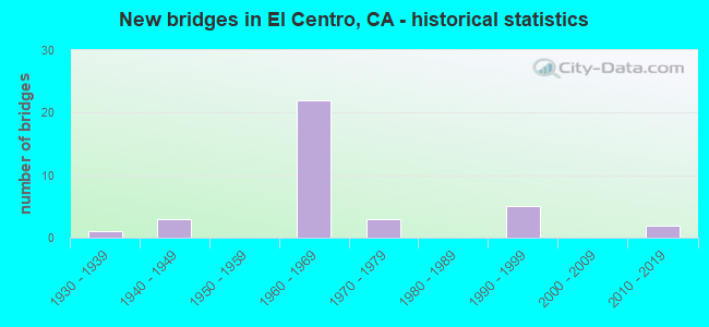
- New bridges - historical statistics
- 11930-1939
- 31940-1949
- 221960-1969
- 31970-1979
- 51990-1999
- 22010-2019
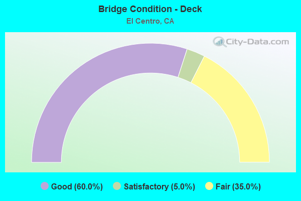
- Bridge Condition - Deck
- 60.0%Good
- 5.0%Satisfactory
- 35.0%Fair
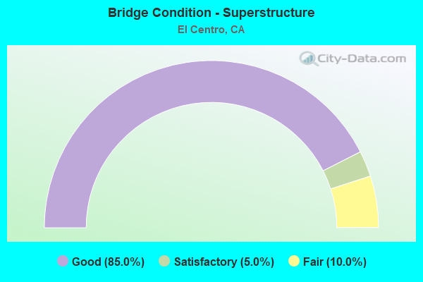
- Bridge Condition - Superstructure
- 85.0%Good
- 5.0%Satisfactory
- 10.0%Fair
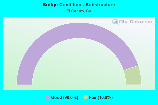
- Bridge Condition - Substructure
- 90.0%Good
- 10.0%Fair
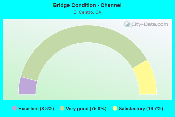
- Bridge Condition - Channel
- 8.3%Excellent
- 75.0%Very good
- 16.7%Satisfactory
Find on map >> Show street view
Structure Number: 58 0248, Location: 11-IMP-008-R33.99 (Lat: 32.773864, Lng: -115.620622), Route carried "on" structure: County highway W972, Year Built: 1967, Status: Open, Structure Length: 5.43m (17.81ft), Average Daily Traffic: 2,770 (year 2019), Truck Traffic: 10%, Average Future Daily Traffic: 7,963 (year 2038), Design Load: HS 20, Features Intersected: INTERSTATE 8, Facility Carried by Structure: FORESTER ROAD
Minimum Vertical Clearance: 30+ m (98+ ft), Kilometerpoint: 0.000, Lanes on structure: 2, Lanes under structure: 4, Owner: State Highway Agency, Approaching Roadway Width: 9.8m (32.2ft), Material/Design: Concrete continuous, Design/Construction: Box Beam or Girders - Multiple, Number Of Spans In Main Unit: 2, Length of Maximum Span: 27.1m (88.9ft), Curb-To-Curb Width: 9.8m (32.2ft), Out-to-Out Width: 10.4m (34.1ft)
Condition: Deck: Fair, Superstructure: Good, Substructure: Good, Operating Rating: 45.4 metric tons, Method Used To Determine Operating Rating: Load and Resistance Factor Rating (LRFR) rating reported by rating factor(RF) method using HL-93 loadings, Inventory Rating: 35.0 metric tons, Method Used To Determine Inventory Rating: Load and Resistance Factor Rating (LRFR) rating reported by rating factor(RF) method using HL-93 loadings, Structural Evaluation: Better than present minimum criteria, Deck Geometry: Meets minimum limits, Underclear: Somewhat better than minimum adequacy, Approach Roadway Alignment: Equal to present desirable criteria, Designated Inspection Frequency: Every 24 months, Inspection Date: April 2020, Deck Structure Type: Concrete Cast-file-Place
Find on map >> Show street view
Structure Number: 58 0249L, Location: 11-IMP-008-R35.47 (Lat: 32.773992, Lng: -115.595194), Route carried "on" structure: Interstate 8, Year Built: 1967, Status: Open, Structure Length: 7.04m (23.10ft), Average Daily Traffic: 8,700 (year 2019), Truck Traffic: 14%, Average Future Daily Traffic: 17,972 (year 2038), Design Load: HS 20+Mod, Features Intersected: CENTRAL MAIN CANAL,AUSTN
Minimum Vertical Clearance: 30+ m (98+ ft), Kilometerpoint: 35.470, Lanes on structure: 2, Lanes under structure: 2, Base Highway Network: Yes (, Subroute: 3), Owner: State Highway Agency, Approaching Roadway Width: 11.9m (39.0ft), Material/Design: Concrete continuous, Design/Construction: Box Beam or Girders - Multiple, Number Of Spans In Main Unit: 4, Length of Maximum Span: 27.4m (89.9ft), Curb-To-Curb Width: 11.9m (39.0ft), Out-to-Out Width: 12.5m (41.0ft)
Condition: Deck: Good, Superstructure: Good, Substructure: Good, Channel: Satisfactory, Operating Rating: 45.4 metric tons, Method Used To Determine Operating Rating: Load and Resistance Factor Rating (LRFR) rating reported by rating factor(RF) method using HL-93 loadings, Inventory Rating: 35.0 metric tons, Method Used To Determine Inventory Rating: Load and Resistance Factor Rating (LRFR) rating reported by rating factor(RF) method using HL-93 loadings, Structural Evaluation: Better than present minimum criteria, Deck Geometry: Equal to present minimum criteria, Underclear: Better than present minimum criteria, Waterway Adequacy: Equal to present desirable criteria, Approach Roadway Alignment: Equal to present desirable criteria, Designated Inspection Frequency: Every 24 months, Inspection Date: April 2020, Deck Structure Type: Concrete Cast-file-Place
Find on map >> Show street view
Structure Number: 58 0249R, Location: 11-IMP-008-R35.47 (Lat: 32.773747, Lng: -115.595197), Route carried "on" structure: Interstate 8, Year Built: 1967, Status: Open, Structure Length: 7.04m (23.10ft), Average Daily Traffic: 8,700 (year 2019), Truck Traffic: 14%, Average Future Daily Traffic: 17,972 (year 2038), Design Load: HS 20+Mod, Features Intersected: CENTRAL MAIN CANAL,AUSTN
Minimum Vertical Clearance: 30+ m (98+ ft), Kilometerpoint: 35.470, Lanes on structure: 2, Lanes under structure: 2, Base Highway Network: Yes (, Subroute: 3), Owner: State Highway Agency, Approaching Roadway Width: 11.9m (39.0ft), Material/Design: Concrete continuous, Design/Construction: Box Beam or Girders - Multiple, Number Of Spans In Main Unit: 4, Length of Maximum Span: 27.4m (89.9ft), Curb-To-Curb Width: 11.9m (39.0ft), Out-to-Out Width: 12.5m (41.0ft)
Condition: Deck: Good, Superstructure: Good, Substructure: Good, Channel: Satisfactory, Operating Rating: 45.0 metric tons, Method Used To Determine Operating Rating: Load and Resistance Factor Rating (LRFR) rating reported by rating factor(RF) method using HL-93 loadings, Inventory Rating: 34.7 metric tons, Method Used To Determine Inventory Rating: Load and Resistance Factor Rating (LRFR) rating reported by rating factor(RF) method using HL-93 loadings, Structural Evaluation: Better than present minimum criteria, Deck Geometry: Equal to present minimum criteria, Underclear: Equal to present minimum criteria, Waterway Adequacy: Equal to present desirable criteria, Approach Roadway Alignment: Equal to present desirable criteria, Designated Inspection Frequency: Every 24 months, Inspection Date: April 2020, Deck Structure Type: Concrete Cast-file-Place
Find on map >> Show street view
Structure Number: 58 025, Location: 11-IMP-008-R36.46-ECN (Lat: 32.774161, Lng: -115.578317), Route carried "on" structure: County highway Y669, Year Built: 1967, Status: Open, Structure Length: 5.43m (17.81ft), Average Daily Traffic: 5,040 (year 2009), Truck Traffic: 10%, Average Future Daily Traffic: 7,990 (year 2038), Design Load: HS 20, Features Intersected: INTERSTATE 8, Facility Carried by Structure: LA BRUCHERIE ROAD
Minimum Vertical Clearance: 30+ m (98+ ft), Kilometerpoint: 0.000, Lanes on structure: 2, Lanes under structure: 4, Owner: State Highway Agency, Approaching Roadway Width: 9.8m (32.2ft), Material/Design: Concrete continuous, Design/Construction: Box Beam or Girders - Multiple, Number Of Spans In Main Unit: 2, Length of Maximum Span: 27.1m (88.9ft), Curb-To-Curb Width: 9.8m (32.2ft), Out-to-Out Width: 10.4m (34.1ft)
Condition: Deck: Good, Superstructure: Good, Substructure: Good, Operating Rating: 45.4 metric tons, Method Used To Determine Operating Rating: Load and Resistance Factor Rating (LRFR) rating reported by rating factor(RF) method using HL-93 loadings, Inventory Rating: 35.0 metric tons, Method Used To Determine Inventory Rating: Load and Resistance Factor Rating (LRFR) rating reported by rating factor(RF) method using HL-93 loadings, Structural Evaluation: Better than present minimum criteria, Deck Geometry: Meets minimum limits, Underclear: Somewhat better than minimum adequacy, Approach Roadway Alignment: Equal to present desirable criteria, Designated Inspection Frequency: Every 48 months, Inspection Date: April 2018, Deck Structure Type: Concrete Cast-file-Place
Find on map >> Show street view
Structure Number: 58 0251, Location: 11-IMP-008-R36.97-ECN (Lat: 32.774156, Lng: -115.569522), Route carried "on" structure: City street Y671, Year Built: 1967, Status: Open, Structure Length: 6.58m (21.59ft), Average Daily Traffic: 23,361 (year 2019), Truck Traffic: 5%, Average Future Daily Traffic: 31,536 (year 2038), Design Load: HS 20, Features Intersected: INTERSTATE 8, Facility Carried by Structure: E8-IMPERIAL-E8
Minimum Vertical Clearance: 30+ m (98+ ft), Kilometerpoint: 0.000, Lanes on structure: 2, Lanes under structure: 5, Base Highway Network: Yes, Owner: State Highway Agency, Approaching Roadway Width: 9.8m (32.2ft), Skew: 9 degrees, Material/Design: Concrete continuous, Design/Construction: Box Beam or Girders - Multiple, Number Of Spans In Main Unit: 2, Length of Maximum Span: 37.5m (123.0ft), Curb-To-Curb Width: 9.8m (32.2ft), Out-to-Out Width: 10.4m (34.1ft)
Condition: Deck: Fair, Superstructure: Good, Substructure: Good, Operating Rating: 49.2 metric tons, Method Used To Determine Operating Rating: Load and Resistance Factor Rating (LRFR) rating reported by rating factor(RF) method using HL-93 loadings, Inventory Rating: 37.9 metric tons, Method Used To Determine Inventory Rating: Load and Resistance Factor Rating (LRFR) rating reported by rating factor(RF) method using HL-93 loadings, Structural Evaluation: Better than present minimum criteria, Deck Geometry: Meets minimum limits, Underclear: Somewhat better than minimum adequacy, Approach Roadway Alignment: Equal to present desirable criteria, Designated Inspection Frequency: Every 24 months, Inspection Date: April 2020, Deck Structure Type: Concrete Cast-file-Place
Find on map >> Show street view
Structure Number: 58 0252, Location: 11-IMP-008-R37.46-ECN (Lat: 32.774100, Lng: -115.561147), Route carried "on" structure: City street Y673, Year Built: 1967, Status: Open, Structure Length: 5.43m (17.81ft), Average Daily Traffic: 9,650 (year 2019), Truck Traffic: 6%, Average Future Daily Traffic: 15,979 (year 2038), Design Load: HS 20, Features Intersected: INTERSTATE 8, Facility Carried by Structure: EIGHTH STREET
Minimum Vertical Clearance: 30+ m (98+ ft), Kilometerpoint: 0.000, Lanes on structure: 2, Lanes under structure: 4, Owner: State Highway Agency, Approaching Roadway Width: 9.8m (32.2ft), Material/Design: Concrete continuous, Design/Construction: Box Beam or Girders - Multiple, Number Of Spans In Main Unit: 2, Length of Maximum Span: 27.1m (88.9ft), Curb-To-Curb Width: 9.8m (32.2ft), Out-to-Out Width: 10.4m (34.1ft)
Condition: Deck: Fair, Superstructure: Good, Substructure: Good, Operating Rating: 45.4 metric tons, Method Used To Determine Operating Rating: Load and Resistance Factor Rating (LRFR) rating reported by rating factor(RF) method using HL-93 loadings, Inventory Rating: 35.0 metric tons, Method Used To Determine Inventory Rating: Load and Resistance Factor Rating (LRFR) rating reported by rating factor(RF) method using HL-93 loadings, Structural Evaluation: Better than present minimum criteria, Deck Geometry: Meets minimum limits, Underclear: Somewhat better than minimum adequacy, Approach Roadway Alignment: Equal to present desirable criteria, Designated Inspection Frequency: Every 24 months, Inspection Date: April 2020, Deck Structure Type: Concrete Cast-file-Place
Find on map >> Show street view
Structure Number: 58 0253L, Location: 11-IMP-008-R37.96-ECN (Lat: 32.773881, Lng: -115.552450), Route carried "on" structure: Interstate 8, Year Built: 1967, Status: Open, Structure Length: 4.63m (15.19ft), Average Daily Traffic: 16,000 (year 2019), Truck Traffic: 11%, Average Future Daily Traffic: 33,890 (year 2038), Design Load: HS 20, Features Intersected: STATE ROUTE 86
Minimum Vertical Clearance: 30+ m (98+ ft), Kilometerpoint: 37.960, Lanes on structure: 2, Lanes under structure: 5, Base Highway Network: Yes (, Subroute: 3), Owner: State Highway Agency, Approaching Roadway Width: 11.9m (39.0ft), Skew: 1 degrees, Material/Design: Concrete continuous, Design/Construction: Box Beam or Girders - Multiple, Number Of Spans In Main Unit: 4, Length of Maximum Span: 16.2m (53.1ft), Curb-To-Curb Width: 11.9m (39.0ft), Out-to-Out Width: 12.5m (41.0ft)
Condition: Deck: Good, Superstructure: Good, Substructure: Good, Operating Rating: 41.8 metric tons, Method Used To Determine Operating Rating: Load and Resistance Factor Rating (LRFR) rating reported by rating factor(RF) method using HL-93 loadings, Inventory Rating: 32.1 metric tons, Method Used To Determine Inventory Rating: Load and Resistance Factor Rating (LRFR) rating reported by rating factor(RF) method using HL-93 loadings, Structural Evaluation: Better than present minimum criteria, Deck Geometry: Equal to present minimum criteria, Underclear: Equal to present minimum criteria, Approach Roadway Alignment: Equal to present desirable criteria, Designated Inspection Frequency: Every 24 months, Inspection Date: March 2020, Deck Structure Type: Concrete Cast-file-Place
Find on map >> Show street view
Structure Number: 58 0253R, Location: 11-IMP-008-R37.96-ECN (Lat: 32.773633, Lng: -115.552447), Route carried "on" structure: Interstate 8, Year Built: 1967, Status: Open, Structure Length: 4.63m (15.19ft), Average Daily Traffic: 17,000 (year 2019), Truck Traffic: 10%, Average Future Daily Traffic: 37,287 (year 2038), Design Load: HS 20, Features Intersected: STATE ROUTE 86
Minimum Vertical Clearance: 30+ m (98+ ft), Kilometerpoint: 37.960, Lanes on structure: 2, Lanes under structure: 6, Base Highway Network: Yes (, Subroute: 3), Owner: State Highway Agency, Approaching Roadway Width: 11.9m (39.0ft), Material/Design: Concrete continuous, Design/Construction: Box Beam or Girders - Multiple, Number Of Spans In Main Unit: 4, Length of Maximum Span: 16.2m (53.1ft), Curb-To-Curb Width: 11.9m (39.0ft), Out-to-Out Width: 12.5m (41.0ft)
Condition: Deck: Good, Superstructure: Good, Substructure: Good, Operating Rating: 41.8 metric tons, Method Used To Determine Operating Rating: Load and Resistance Factor Rating (LRFR) rating reported by rating factor(RF) method using HL-93 loadings, Inventory Rating: 32.1 metric tons, Method Used To Determine Inventory Rating: Load and Resistance Factor Rating (LRFR) rating reported by rating factor(RF) method using HL-93 loadings, Structural Evaluation: Better than present minimum criteria, Deck Geometry: Equal to present minimum criteria, Underclear: Equal to present minimum criteria, Approach Roadway Alignment: Equal to present desirable criteria, Designated Inspection Frequency: Every 24 months, Inspection Date: March 2020, Deck Structure Type: Concrete Cast-file-Place
Find on map >> Show street view
Structure Number: 58 0254L, Location: 11-IMP-008-R38.48-ECN (Lat: 32.773844, Lng: -115.543533), Route carried "on" structure: Interstate 8, Year Built: 1967, Status: Open, Structure Length: 3.96m (12.99ft), Average Daily Traffic: 17,250 (year 2019), Truck Traffic: 10%, Average Future Daily Traffic: 46,727 (year 2038), Design Load: HS 20+Mod, Features Intersected: UP RR
Minimum Vertical Clearance: 30+ m (98+ ft), Kilometerpoint: 38.480, Lanes on structure: 2, Base Highway Network: Yes (, Subroute: 3), Owner: State Highway Agency, Approaching Roadway Width: 11.9m (39.0ft), Skew: 1 degrees, Material/Design: Concrete continuous, Design/Construction: Box Beam or Girders - Multiple, Number Of Spans In Main Unit: 3, Length of Maximum Span: 15.2m (49.9ft), Curb-To-Curb Width: 11.9m (39.0ft), Out-to-Out Width: 12.5m (41.0ft)
Condition: Deck: Good, Superstructure: Good, Substructure: Good, Operating Rating: 41.8 metric tons, Method Used To Determine Operating Rating: Load and Resistance Factor Rating (LRFR) rating reported by rating factor(RF) method using HL-93 loadings, Inventory Rating: 31.4 metric tons, Method Used To Determine Inventory Rating: Load and Resistance Factor Rating (LRFR) rating reported by rating factor(RF) method using HL-93 loadings, Structural Evaluation: Better than present minimum criteria, Deck Geometry: Equal to present minimum criteria, Underclear: Better than present minimum criteria, Approach Roadway Alignment: Equal to present desirable criteria, Designated Inspection Frequency: Every 24 months, Inspection Date: March 2020, Deck Structure Type: Concrete Cast-file-Place
Find on map >> Show street view
Structure Number: 58 0254R, Location: 11-IMP-008-R38.48-ECN (Lat: 32.773603, Lng: -115.543433), Route carried "on" structure: Interstate 8, Year Built: 1967, Status: Open, Structure Length: 3.96m (12.99ft), Average Daily Traffic: 17,250 (year 2019), Truck Traffic: 10%, Average Future Daily Traffic: 46,727 (year 2038), Design Load: HS 20+Mod, Features Intersected: UP RR
Minimum Vertical Clearance: 30+ m (98+ ft), Kilometerpoint: 38.480, Lanes on structure: 2, Base Highway Network: Yes (, Subroute: 3), Owner: State Highway Agency, Approaching Roadway Width: 11.9m (39.0ft), Skew: 1 degrees, Material/Design: Concrete continuous, Design/Construction: Box Beam or Girders - Multiple, Number Of Spans In Main Unit: 3, Length of Maximum Span: 15.2m (49.9ft), Curb-To-Curb Width: 11.9m (39.0ft), Out-to-Out Width: 12.5m (41.0ft)
Condition: Deck: Good, Superstructure: Good, Substructure: Good, Operating Rating: 41.8 metric tons, Method Used To Determine Operating Rating: Load and Resistance Factor Rating (LRFR) rating reported by rating factor(RF) method using HL-93 loadings, Inventory Rating: 31.4 metric tons, Method Used To Determine Inventory Rating: Load and Resistance Factor Rating (LRFR) rating reported by rating factor(RF) method using HL-93 loadings, Structural Evaluation: Better than present minimum criteria, Deck Geometry: Equal to present minimum criteria, Underclear: Better than present minimum criteria, Approach Roadway Alignment: Equal to present desirable criteria, Designated Inspection Frequency: Every 24 months, Inspection Date: March 2020, Deck Structure Type: Concrete Cast-file-Place
Find on map >> Show street view
Structure Number: 58 0256L, Location: 11-IMP-008-R40.92 (Lat: 32.773853, Lng: -115.501531), Route carried "on" structure: Interstate 8, Year Built: 1967, Status: Open, Structure Length: 6.40m (21.00ft), Average Daily Traffic: 16,000 (year 2019), Truck Traffic: 10%, Average Future Daily Traffic: 44,160 (year 2038), Design Load: HS 20, Features Intersected: STATE ROUTE 111
Minimum Vertical Clearance: 30+ m (98+ ft), Kilometerpoint: 40.920, Lanes on structure: 3, Lanes under structure: 4, Base Highway Network: Yes (, Subroute: 3), Owner: State Highway Agency, Approaching Roadway Width: 17.1m (56.1ft), Material/Design: Concrete continuous, Design/Construction: Box Beam or Girders - Multiple, Number Of Spans In Main Unit: 2, Length of Maximum Span: 32.0m (105.0ft), Curb-To-Curb Width: 17.1m (56.1ft), Out-to-Out Width: 17.7m (58.1ft)
Condition: Deck: Fair, Superstructure: Good, Substructure: Good, Operating Rating: 48.6 metric tons, Method Used To Determine Operating Rating: Load and Resistance Factor Rating (LRFR) rating reported by rating factor(RF) method using HL-93 loadings, Inventory Rating: 34.7 metric tons, Method Used To Determine Inventory Rating: Load and Resistance Factor Rating (LRFR) rating reported by rating factor(RF) method using HL-93 loadings, Structural Evaluation: Better than present minimum criteria, Deck Geometry: Equal to present minimum criteria, Underclear: Better than present minimum criteria, Approach Roadway Alignment: Equal to present desirable criteria, Designated Inspection Frequency: Every 24 months, Inspection Date: March 2020, Deck Structure Type: Concrete Cast-file-Place
Find on map >> Show street view
Structure Number: 58 0256R, Location: 11-IMP-008-R40.92 (Lat: 32.773561, Lng: -115.501553), Route carried "on" structure: Interstate 8, Year Built: 1967, Status: Open, Structure Length: 6.40m (21.00ft), Average Daily Traffic: 16,000 (year 2019), Truck Traffic: 10%, Average Future Daily Traffic: 44,160 (year 2038), Design Load: HS 20, Features Intersected: STATE ROUTE 111
Minimum Vertical Clearance: 30+ m (98+ ft), Kilometerpoint: 40.920, Lanes on structure: 3, Lanes under structure: 4, Base Highway Network: Yes (, Subroute: 3), Owner: State Highway Agency, Approaching Roadway Width: 15.5m (50.9ft), Material/Design: Concrete continuous, Design/Construction: Box Beam or Girders - Multiple, Number Of Spans In Main Unit: 2, Length of Maximum Span: 32.0m (105.0ft), Curb-To-Curb Width: 16.9m (55.4ft), Out-to-Out Width: 17.5m (57.4ft)
Condition: Deck: Good, Superstructure: Good, Substructure: Good, Operating Rating: 45.7 metric tons, Method Used To Determine Operating Rating: Load and Resistance Factor Rating (LRFR) rating reported by rating factor(RF) method using HL-93 loadings, Inventory Rating: 35.3 metric tons, Method Used To Determine Inventory Rating: Load and Resistance Factor Rating (LRFR) rating reported by rating factor(RF) method using HL-93 loadings, Structural Evaluation: Better than present minimum criteria, Deck Geometry: Equal to present minimum criteria, Underclear: Equal to present minimum criteria, Approach Roadway Alignment: Equal to present desirable criteria, Designated Inspection Frequency: Every 24 months, Inspection Date: March 2020, Deck Structure Type: Concrete Cast-file-Place
Find on map >> Show street view
Structure Number: 58 033, Location: 11-IMP-007-S0.35 (Lat: 32.683244, Lng: -115.387147), Route carried "on" structure: Spur State highway 7, Year Built: 1996, Status: Open, Structure Length: 3.00m (9.84ft), Average Daily Traffic: 9,400 (year 2019), Truck Traffic: 40%, Average Future Daily Traffic: 12,201 (year 2041), Design Load: HS 20+Mod, Features Intersected: SOUTH ALAMO CANAL
Minimum Vertical Clearance: 30+ m (98+ ft), Kilometerpoint: 0.350, Lanes on structure: 4, Base Highway Network: Yes, Owner: State Highway Agency, Approaching Roadway Width: 23.9m (78.4ft), Skew: 20 degrees, Material/Design: Prestressed concrete, Design/Construction: Box Beam or Girders - Multiple, Number Of Spans In Main Unit: 1, Length of Maximum Span: 28.8m (94.5ft), Curb-To-Curb Width: 23.9m (78.4ft), Out-to-Out Width: 24.9m (81.7ft)
Condition: Deck: Fair, Superstructure: Good, Substructure: Good, Channel: Very good, Operating Rating: 54.1 metric tons, Method Used To Determine Operating Rating: Assigned rating based on Load Factor Design (LFD) reported in metric tons, Inventory Rating: 32.4 metric tons, Method Used To Determine Inventory Rating: Assigned rating based on Load Factor Design (LFD) reported in metric tons, Structural Evaluation: Better than present minimum criteria, Deck Geometry: Superior to present desirable criteria, Waterway Adequacy: Equal to present desirable criteria, Approach Roadway Alignment: Equal to present desirable criteria, Designated Inspection Frequency: Every 24 months, Inspection Date: December 2020, Deck Structure Type: Concrete Cast-file-Place
Find on map >> Show street view
Structure Number: 58 035, Location: 11-IMP-098-45.63 (Lat: 32.698489, Lng: -115.281325), Route carried "on" structure: State highway 98, Year Built: 1938, Status: Open, Structure Length: 1.70m (5.58ft), Average Daily Traffic: 2,850 (year 2011), Truck Traffic: 10%, Average Future Daily Traffic: 7,651 (year 2038), Features Intersected: EAST HIGHLINE CANAL #2
Minimum Vertical Clearance: 30+ m (98+ ft), Kilometerpoint: 45.630, Lanes on structure: 2, Base Highway Network: Yes (, Subroute: 1), Owner: State Highway Agency, Approaching Roadway Width: 12.1m (39.7ft), Material/Design: Concrete, Design/Construction: Culvert, Number Of Spans In Main Unit: 5, Length of Maximum Span: 3.3m (10.8ft), Curb-To-Curb Width: 12.1m (39.7ft), Out-to-Out Width: 23.0m (75.5ft)
Condition: Channel: Excellent, Culverts: Good, Operating Rating: 40.5 metric tons, Method Used To Determine Operating Rating: Field evaluation and documented engineering judgment, Inventory Rating: 24.3 metric tons, Method Used To Determine Inventory Rating: Field evaluation and documented engineering judgment, Structural Evaluation: Equal to present minimum criteria, Deck Geometry: Somewhat better than minimum adequacy, Waterway Adequacy: Superior to present desirable criteria, Approach Roadway Alignment: Equal to present desirable criteria, Designated Inspection Frequency: Every 24 months, Underwater Inspection Frequency: Every 60 months, Inspection Date: Febuary 2021, Underwater Inspection Date: January 2022
Find on map >> Show street view
Structure Number: 58 0351, Location: 11-IMP-008-R39.00-ECN (Lat: 32.773944, Lng: -115.535250), Route carried "on" structure: City street Y565, Year Built: 2017, Status: Open, Structure Length: 6.10m (20.01ft), Average Daily Traffic: 4,070 (year 2019), Truck Traffic: 4%, Average Future Daily Traffic: 8,906 (year 2038), Design Load: HL 93, Features Intersected: INTERSTATE 8, Facility Carried by Structure: DOGWOOD ROAD
Minimum Vertical Clearance: 30+ m (98+ ft), Kilometerpoint: 0.000, Lanes on structure: 6, Lanes under structure: 5, Owner: State Highway Agency, Approaching Roadway Width: 25.6m (84.0ft), Material/Design: Prestressed concrete continuous, Design/Construction: Box Beam or Girders - Multiple, Number Of Spans In Main Unit: 2, Length of Maximum Span: 30.5m (100.1ft), Curb or Sidewalk Widths: Left: 1.5m (4.9ft), Right: 1.5m (4.9ft), Curb-To-Curb Width: 25.6m (84.0ft), Out-to-Out Width: 29.3m (96.1ft)
Condition: Deck: Good, Superstructure: Good, Substructure: Good, Operating Rating: 42.1 metric tons, Method Used To Determine Operating Rating: Assigned ratings based on Load and Resistance Factor Design (LRFD) reported by rating factor (RF) using HL93 loadings, Inventory Rating: 32.4 metric tons, Method Used To Determine Inventory Rating: Assigned ratings based on Load and Resistance Factor Design (LRFD) reported by rating factor (RF) using HL93 loadings, Structural Evaluation: Better than present minimum criteria, Deck Geometry: Somewhat better than minimum adequacy, Underclear: Better than present minimum criteria, Approach Roadway Alignment: Equal to present desirable criteria, Designated Inspection Frequency: Every 24 months, Inspection Date: March 2020, Deck Structure Type: Concrete Cast-file-Place
Find on map >> Show street view
Structure Number: 58C0066, Location: 25 FT E/O AUSTIN RD (Lat: 32.796508, Lng: -115.594814), Route carried "on" structure: County highway , Year Built: 1940, Status: Open, Structure Length: 1.55m (5.09ft), Average Daily Traffic: 10,500 (year 2016), Truck Traffic: 1%, Average Future Daily Traffic: 12,854 (year 2038), Features Intersected: CENTRAL MAIN CANAL, Facility Carried by Structure: EVAN HEWES HWY
Minimum Vertical Clearance: 30+ m (98+ ft), Kilometerpoint: 0.000, Lanes on structure: 2, Owner: County Highway Agency, Approaching Roadway Width: 9.1m (29.9ft), Material/Design: Concrete continuous, Design/Construction: Slab, Number Of Spans In Main Unit: 3, Length of Maximum Span: 9.1m (29.9ft), Curb or Sidewalk Widths: Left: 0.9m (3.0ft), Right: 0.9m (3.0ft), Curb-To-Curb Width: 11.0m (36.1ft), Out-to-Out Width: 13.0m (42.7ft)
Condition: Deck: Good, Superstructure: Good, Substructure: Fair, Channel: Very good, Operating Rating: 54.1 metric tons, Method Used To Determine Operating Rating: Load Factor (LF), Inventory Rating: 32.4 metric tons, Method Used To Determine Inventory Rating: Load Factor (LF), Structural Evaluation: Somewhat better than minimum adequacy, Deck Geometry: Meets minimum limits, Waterway Adequacy: Equal to present desirable criteria, Approach Roadway Alignment: Equal to present desirable criteria, Designated Inspection Frequency: Every 24 months, Inspection Date: March 2021, Deck Structure Type: Concrete Cast-file-Place, Wearing Surface/Protective System: Wearing Surface: Bituminous
Find on map >> Show street view
Structure Number: 58C0067, Location: 0.6 MI N/O KUBLER RD (Lat: 32.702622, Lng: -115.583756), Route carried "on" structure: County highway , Year Built: 1973, Status: Open, Structure Length: 3.05m (10.01ft), Average Daily Traffic: 800 (year 2016), Truck Traffic: 2%, Average Future Daily Traffic: 1,199 (year 2038), Design Load: HS 20+Mod, Features Intersected: NEW RIVER, Facility Carried by Structure: LA BRUCHERIE RD
Minimum Vertical Clearance: 30+ m (98+ ft), Kilometerpoint: 0.000, Lanes on structure: 2, Owner: County Highway Agency, Approaching Roadway Width: 9.8m (32.2ft), Skew: 2 degrees, Material/Design: Concrete continuous, Design/Construction: Slab, Number Of Spans In Main Unit: 4, Length of Maximum Span: 8.2m (26.9ft), Curb-To-Curb Width: 9.8m (32.2ft), Out-to-Out Width: 9.9m (32.5ft)
Condition: Deck: Fair, Superstructure: Fair, Substructure: Good, Channel: Very good, Operating Rating: 93.6 metric tons, Method Used To Determine Operating Rating: Load Factor (LF), Inventory Rating: 56.4 metric tons, Method Used To Determine Inventory Rating: Load Factor (LF), Structural Evaluation: Somewhat better than minimum adequacy, Deck Geometry: Equal to present minimum criteria, Waterway Adequacy: Equal to present desirable criteria, Approach Roadway Alignment: Equal to present minimum criteria, Designated Inspection Frequency: Every 24 months, Underwater Inspection Frequency: Every 60 months, Inspection Date: March 2021, Underwater Inspection Date: November 2019, Deck Structure Type: Concrete Cast-file-Place
Find on map >> Show street view
Structure Number: 58C0068, Location: 2.9 MI S/O MCCABE RD (Lat: 32.710008, Lng: -115.577461), Route carried "on" structure: County highway , Year Built: 1973, Status: Open, Structure Length: 3.05m (10.01ft), Average Daily Traffic: 800 (year 2016), Truck Traffic: 1%, Average Future Daily Traffic: 1,109 (year 2038), Design Load: HS 20, Features Intersected: CENTRAL MAIN CANAL, Facility Carried by Structure: LA BRUCHERIE RD
Minimum Vertical Clearance: 30+ m (98+ ft), Kilometerpoint: 0.000, Lanes on structure: 2, Owner: County Highway Agency, Approaching Roadway Width: 7.3m (24.0ft), Skew: 1 degrees, Material/Design: Concrete continuous, Design/Construction: Slab, Number Of Spans In Main Unit: 4, Length of Maximum Span: 8.2m (26.9ft), Curb-To-Curb Width: 9.8m (32.2ft), Out-to-Out Width: 9.9m (32.5ft)
Condition: Deck: Satisfactory, Superstructure: Satisfactory, Substructure: Good, Channel: Very good, Operating Rating: 93.6 metric tons, Method Used To Determine Operating Rating: Load Factor (LF), Inventory Rating: 56.4 metric tons, Method Used To Determine Inventory Rating: Load Factor (LF), Structural Evaluation: Equal to present minimum criteria, Deck Geometry: Equal to present minimum criteria, Waterway Adequacy: Superior to present desirable criteria, Approach Roadway Alignment: Equal to present desirable criteria, Designated Inspection Frequency: Every 48 months, Inspection Date: March 2021, Deck Structure Type: Concrete Cast-file-Place
Find on map >> Show street view
Structure Number: 58C0079, Location: 25 FT E/O AUSTIN RD (Lat: 32.752422, Lng: -115.594817), Route carried "on" structure: County highway , Year Built: 1975, Status: Open, Structure Length: 1.92m (6.30ft), Average Daily Traffic: 1,100 (year 2019), Truck Traffic: 1%, Average Future Daily Traffic: 1,609 (year 2041), Design Load: HS 20, Features Intersected: CENTRAL MAIN CANAL, Facility Carried by Structure: MCCABE RD
Minimum Vertical Clearance: 30+ m (98+ ft), Kilometerpoint: 0.000, Lanes on structure: 2, Owner: County Highway Agency, Approaching Roadway Width: 7.3m (24.0ft), Material/Design: Concrete continuous, Design/Construction: Slab, Number Of Spans In Main Unit: 2, Length of Maximum Span: 8.8m (28.9ft), Curb-To-Curb Width: 9.8m (32.2ft), Out-to-Out Width: 9.9m (32.5ft)
Condition: Deck: Fair, Superstructure: Fair, Substructure: Good, Channel: Very good, Operating Rating: 99.8 metric tons, Method Used To Determine Operating Rating: Load Factor (LF), Inventory Rating: 61.2 metric tons, Method Used To Determine Inventory Rating: Load Factor (LF), Structural Evaluation: Somewhat better than minimum adequacy, Deck Geometry: Somewhat better than minimum adequacy, Waterway Adequacy: Equal to present desirable criteria, Approach Roadway Alignment: Equal to present desirable criteria, Designated Inspection Frequency: Every 24 months, Underwater Inspection Frequency: Every 60 months, Inspection Date: March 2021, Underwater Inspection Date: January 2022, Deck Structure Type: Concrete Cast-file-Place
Find on map >> Show street view
Structure Number: 58C0112, Location: 2.0 MI E/O BROCKMAN RD (Lat: 32.716950, Lng: -115.604225), Route carried "on" structure: County highway , Year Built: 1940, Status: Open, Structure Length: 2.77m (9.09ft), Average Daily Traffic: 500 (year 2016), Truck Traffic: 1%, Average Future Daily Traffic: 751 (year 2038), Features Intersected: NEW RIVER, Facility Carried by Structure: LYONS RD
Minimum Vertical Clearance: 30+ m (98+ ft), Kilometerpoint: 0.000, Lanes on structure: 2, Owner: County Highway Agency, Approaching Roadway Width: 7.6m (24.9ft), Skew: 2 degrees, Material/Design: Wood or Timber, Design/Construction: Stringer/Multi-beam, Number Of Spans In Main Unit: 6, Length of Maximum Span: 4.6m (15.1ft), Curb-To-Curb Width: 7.5m (24.6ft), Out-to-Out Width: 7.9m (25.9ft)
Condition: Deck: Good, Superstructure: Good, Substructure: Good, Channel: Very good, Operating Rating: 39.5 metric tons, Method Used To Determine Operating Rating: Allowable Stress (AS), Inventory Rating: 28.2 metric tons, Method Used To Determine Inventory Rating: Allowable Stress (AS), Structural Evaluation: Better than present minimum criteria, Deck Geometry: Meets minimum limits, Waterway Adequacy: Better than present minimum criteria, Approach Roadway Alignment: Equal to present minimum criteria, Designated Inspection Frequency: Every 24 months, Underwater Inspection Frequency: Every 60 months, Inspection Date: March 2021, Underwater Inspection Date: November 2019, Deck Structure Type: Wood or Timber, Wearing Surface/Protective System: Wearing Surface: Bituminous
Find on map >> Show street view
Structure Number: 58C0114, Location: 50 FT E/O AUSTIN RD (Lat: 32.723392, Lng: -115.594769), Route carried "on" structure: County highway , Year Built: 1940, Status: Open, Structure Length: 1.40m (4.59ft), Average Daily Traffic: 1,000 (year 2021), Truck Traffic: 1%, Average Future Daily Traffic: 1,427 (year 2043), Features Intersected: CENTRAL MAIN CANAL, Facility Carried by Structure: WAHL RD
Minimum Vertical Clearance: 30+ m (98+ ft), Kilometerpoint: 0.000, Lanes on structure: 2, Owner: County Highway Agency, Approaching Roadway Width: 7.5m (24.6ft), Material/Design: Wood or Timber, Design/Construction: Stringer/Multi-beam, Number Of Spans In Main Unit: 3, Length of Maximum Span: 4.6m (15.1ft), Curb-To-Curb Width: 7.5m (24.6ft), Out-to-Out Width: 7.9m (25.9ft)
Condition: Deck: Good, Superstructure: Good, Substructure: Fair, Channel: Very good, Operating Rating: 42.8 metric tons, Method Used To Determine Operating Rating: Allowable Stress (AS), Inventory Rating: 31.1 metric tons, Method Used To Determine Inventory Rating: Allowable Stress (AS), Structural Evaluation: Somewhat better than minimum adequacy, Deck Geometry: Meets minimum limits, Waterway Adequacy: Superior to present desirable criteria, Approach Roadway Alignment: Equal to present desirable criteria, Designated Inspection Frequency: Every 24 months, Inspection Date: March 2021, Deck Structure Type: Wood or Timber, Wearing Surface/Protective System: Wearing Surface: Bituminous
Find on map >> Show street view
Structure Number: 58C0215, Location: 50 FT E/O AUSTIN RD (Lat: 32.781367, Lng: -115.594789), Route carried "on" structure: City street , Year Built: 1990, Status: Open, Structure Length: 0.91m (2.99ft), Average Daily Traffic: 467 (year 2016), Truck Traffic: 1%, Average Future Daily Traffic: 534 (year 2038), Features Intersected: CENTRAL MAIN CANAL, Facility Carried by Structure: ROSS RD
Minimum Vertical Clearance: 30+ m (98+ ft), Kilometerpoint: 0.000, Lanes on structure: 2, Owner: County Highway Agency, Approaching Roadway Width: 7.3m (24.0ft), Material/Design: Concrete, Design/Construction: Culvert, Number Of Spans In Main Unit: 3, Length of Maximum Span: 2.1m (6.9ft)
Condition: Channel: Very good, Culverts: Good, Operating Rating: 54.1 metric tons, Method Used To Determine Operating Rating: Field evaluation and documented engineering judgment, Inventory Rating: 32.4 metric tons, Method Used To Determine Inventory Rating: Field evaluation and documented engineering judgment, Structural Evaluation: Better than present minimum criteria, Waterway Adequacy: Equal to present desirable criteria, Approach Roadway Alignment: Equal to present desirable criteria, Designated Inspection Frequency: Every 48 months, Inspection Date: March 2021
Find on map >> Show street view
Structure Number: 58C0217, Location: 50 FT E/O AUSTIN RD (Lat: 32.792717, Lng: -115.594789), Route carried "on" structure: County highway , Year Built: 1993, Status: Open, Structure Length: 0.91m (2.99ft), Average Daily Traffic: 1,604 (year 2016), Truck Traffic: 2%, Average Future Daily Traffic: 2,137 (year 2038), Features Intersected: CENTRAL MAIN CANAL, Facility Carried by Structure: W. MAIN ST
Minimum Vertical Clearance: 30+ m (98+ ft), Kilometerpoint: 0.000, Lanes on structure: 2, Owner: County Highway Agency, Approaching Roadway Width: 7.8m (25.6ft), Material/Design: Concrete, Design/Construction: Culvert, Number Of Spans In Main Unit: 3, Length of Maximum Span: 3.0m (9.8ft)
Condition: Channel: Very good, Culverts: Good, Operating Rating: 54.1 metric tons, Method Used To Determine Operating Rating: Field evaluation and documented engineering judgment, Inventory Rating: 32.4 metric tons, Method Used To Determine Inventory Rating: Field evaluation and documented engineering judgment, Structural Evaluation: Better than present minimum criteria, Waterway Adequacy: Equal to present desirable criteria, Approach Roadway Alignment: Equal to present desirable criteria, Designated Inspection Frequency: Every 48 months, Inspection Date: March 2021
Find on map >> Show street view
Structure Number: 58 0248, Location: 11-IMP-008-R33.99 (Lat: 32.773864, Lng: -115.620622), Route carried "under" structure: Interstate 8, Year Built: 1967, Structure Length: 0. m, Average Daily Traffic: 12,200 (year 2019), Truck Traffic: 16%, Features Intersected: INTERSTATE 8, Facility Carried by Structure: FORESTER ROAD
Minimum Vertical Clearance: 5.08m (16.67ft), Kilometerpoint: 33.990, Lanes on structure: 2, Lanes under structure: 4, Material/Design: Concrete continuous, Design/Construction: Box Beam or Girders - Multiple, Length of Maximum Span: 27.1m (88.9ft)
Find on map >> Show street view
Structure Number: 58 0249L, Location: 11-IMP-008-R35.47 (Lat: 32.773992, Lng: -115.595194), Route carried "under" structure: County highway Y667, Year Built: 1967, Structure Length: 0. m, Average Daily Traffic: 1,920 (year 2019), Truck Traffic: 10%, Features Intersected: CENTRAL MAIN CANAL,AUSTN, Facility Carried by Structure: INTERSTATE 8 WB
Minimum Vertical Clearance: 4.74m (15.55ft), Kilometerpoint: 0.000, Lanes on structure: 2, Lanes under structure: 2, Material/Design: Concrete continuous, Design/Construction: Box Beam or Girders - Multiple, Length of Maximum Span: 27.4m (89.9ft)
Find on map >> Show street view
Structure Number: 58 0249R, Location: 11-IMP-008-R35.47 (Lat: 32.773747, Lng: -115.595197), Route carried "under" structure: County highway Y667, Year Built: 1967, Structure Length: 0. m, Average Daily Traffic: 1,920 (year 2019), Truck Traffic: 10%, Features Intersected: CENTRAL MAIN CANAL,AUSTN, Facility Carried by Structure: INTERSTATE 8 EB
Minimum Vertical Clearance: 4.60m (15.09ft), Kilometerpoint: 0.000, Lanes on structure: 2, Lanes under structure: 2, Material/Design: Concrete continuous, Design/Construction: Box Beam or Girders - Multiple, Length of Maximum Span: 27.4m (89.9ft)
Find on map >> Show street view
Structure Number: 58 025, Location: 11-IMP-008-R36.46-ECN (Lat: 32.774161, Lng: -115.578317), Route carried "under" structure: Interstate 8, Year Built: 1967, Structure Length: 0. m, Average Daily Traffic: 17,400 (year 2009), Truck Traffic: 10%, Features Intersected: INTERSTATE 8, Facility Carried by Structure: LA BRUCHERIE ROAD
Minimum Vertical Clearance: 5.05m (16.57ft), Kilometerpoint: 36.460, Lanes on structure: 2, Lanes under structure: 4, Material/Design: Concrete continuous, Design/Construction: Box Beam or Girders - Multiple, Length of Maximum Span: 27.1m (88.9ft)
Find on map >> Show street view
Structure Number: 58 0251, Location: 11-IMP-008-R36.97-ECN (Lat: 32.774156, Lng: -115.569522), Route carried "under" structure: Interstate 8, Year Built: 1967, Structure Length: 0. m, Average Daily Traffic: 17,400 (year 2019), Truck Traffic: 10%, Features Intersected: INTERSTATE 8
Minimum Vertical Clearance: 4.97m (16.31ft), Kilometerpoint: 36.970, Lanes on structure: 2, Lanes under structure: 5, Material/Design: Concrete continuous, Design/Construction: Box Beam or Girders - Multiple, Length of Maximum Span: 37.5m (123.0ft)
Find on map >> Show street view
Structure Number: 58 0252, Location: 11-IMP-008-R37.46-ECN (Lat: 32.774100, Lng: -115.561147), Route carried "under" structure: Interstate 8, Year Built: 1967, Structure Length: 0. m, Average Daily Traffic: 32,000 (year 2019), Truck Traffic: 11%, Features Intersected: INTERSTATE 8, Facility Carried by Structure: EIGHTH STREET
Minimum Vertical Clearance: 5.02m (16.47ft), Kilometerpoint: 37.460, Lanes on structure: 2, Lanes under structure: 4, Material/Design: Concrete continuous, Design/Construction: Box Beam or Girders - Multiple, Length of Maximum Span: 27.1m (88.9ft)
Find on map >> Show street view
Structure Number: 58 0253L, Location: 11-IMP-008-R37.96-ECN (Lat: 32.773881, Lng: -115.552450), Route carried "under" structure: State highway 86, Year Built: 1967, Structure Length: 0. m, Average Daily Traffic: 28,500 (year 2019), Truck Traffic: 7%, Features Intersected: STATE ROUTE 86, Facility Carried by Structure: INTERSTATE 8 WB
Minimum Vertical Clearance: 4.83m (15.85ft), Kilometerpoint: 6.020, Lanes on structure: 2, Lanes under structure: 5, Material/Design: Concrete continuous, Design/Construction: Box Beam or Girders - Multiple, Length of Maximum Span: 16.2m (53.1ft)
Find on map >> Show street view
Structure Number: 58 0253R, Location: 11-IMP-008-R37.96-ECN (Lat: 32.773633, Lng: -115.552447), Route carried "under" structure: State highway 86, Year Built: 1967, Structure Length: 0. m, Average Daily Traffic: 28,000 (year 2019), Truck Traffic: 7%, Features Intersected: STATE ROUTE 86, Facility Carried by Structure: INTERSTATE 8 EB
Minimum Vertical Clearance: 4.78m (15.68ft), Kilometerpoint: 6.020, Lanes on structure: 2, Lanes under structure: 6, Material/Design: Concrete continuous, Design/Construction: Box Beam or Girders - Multiple, Length of Maximum Span: 16.2m (53.1ft)
Find on map >> Show street view
Structure Number: 58 0256L, Location: 11-IMP-008-R40.92 (Lat: 32.773853, Lng: -115.501531), Route carried "under" structure: State highway 111, Year Built: 1967, Structure Length: 0. m, Average Daily Traffic: 31,500 (year 2019), Truck Traffic: 7%, Features Intersected: STATE ROUTE 111, Facility Carried by Structure: INTERSTATE 8 WB
Minimum Vertical Clearance: 4.80m (15.75ft), Kilometerpoint: 7.710, Lanes on structure: 3, Lanes under structure: 4, Material/Design: Concrete continuous, Design/Construction: Box Beam or Girders - Multiple, Length of Maximum Span: 32.0m (105.0ft)
Find on map >> Show street view
Structure Number: 58 0256R, Location: 11-IMP-008-R40.92 (Lat: 32.773561, Lng: -115.501553), Route carried "under" structure: State highway 111, Year Built: 1967, Structure Length: 0. m, Average Daily Traffic: 31,500 (year 2019), Truck Traffic: 7%, Features Intersected: STATE ROUTE 111, Facility Carried by Structure: INTERSTATE 8 EB
Minimum Vertical Clearance: 4.70m (15.42ft), Kilometerpoint: 7.710, Lanes on structure: 3, Lanes under structure: 4, Material/Design: Concrete continuous, Design/Construction: Box Beam or Girders - Multiple, Length of Maximum Span: 32.0m (105.0ft)
Find on map >> Show street view
Structure Number: 58 0331, Location: 11-IMP-008-R36.45-ECN (Lat: 32.774206, Lng: -115.578358), Route carried "under" structure: Interstate 8, Year Built: 1996, Structure Length: 0. m, Average Daily Traffic: 17,400 (year 2009), Truck Traffic: 10%, Features Intersected: INTERSTATE 8, Facility Carried by Structure: PEDESTRIAN WALKWAY
Minimum Vertical Clearance: 5.90m (19.36ft), Kilometerpoint: 36.450, Lanes under structure: 4, Material/Design: Concrete continuous, Design/Construction: Box Beam or Girders - Single/Spread, Length of Maximum Span: 27.7m (90.9ft)
Find on map >> Show street view
Structure Number: 58 0332, Location: 11-IMP-008-R37.45-ECN (Lat: 32.774136, Lng: -115.561181), Route carried "under" structure: Interstate 8, Year Built: 1996, Structure Length: 0. m, Average Daily Traffic: 32,000 (year 2019), Truck Traffic: 11%, Features Intersected: INTERSTATE 8, Facility Carried by Structure: PEDESTRIAN WALKWAY
Minimum Vertical Clearance: 5.90m (19.36ft), Kilometerpoint: 37.450, Lanes under structure: 4, Material/Design: Concrete continuous, Design/Construction: Box Beam or Girders - Single/Spread, Length of Maximum Span: 27.7m (90.9ft)
Find on map >> Show street view
Structure Number: 58 0351, Location: 11-IMP-008-R39.00-ECN (Lat: 32.773944, Lng: -115.535250), Route carried "under" structure: Interstate 8, Year Built: 2017, Structure Length: 0. m, Average Daily Traffic: 34,500 (year 2019), Truck Traffic: 10%, Features Intersected: INTERSTATE 8, Facility Carried by Structure: DOGWOOD ROAD
Minimum Vertical Clearance: 5.69m (18.67ft), Kilometerpoint: 39.000, Lanes on structure: 6, Lanes under structure: 5, Material/Design: Prestressed concrete continuous, Design/Construction: Box Beam or Girders - Multiple, Length of Maximum Span: 30.5m (100.1ft)