Bridge Statistics for Elizabethtown, Kentucky (KY)
Condition, Traffic, Stress, Structural Evaluation, Project Costs
- National Bridge Inventory (NBI) Statistics
- 121Number of bridges
- 1,171ft / 357mTotal length
- $11,955,000Total costs
- 1,818,704Total average daily traffic
- 432,442Total average daily truck traffic
- National Bridge Inventory (NBI) Registered Bridges for Elizabethtown
- No street view available for this location
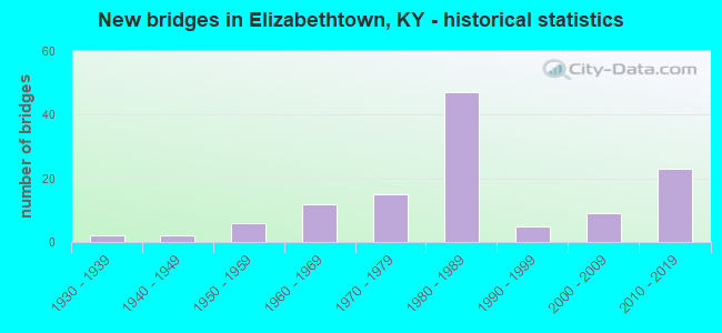
- New bridges - historical statistics
- 21930-1939
- 21940-1949
- 61950-1959
- 121960-1969
- 151970-1979
- 471980-1989
- 51990-1999
- 92000-2009
- 232010-2019
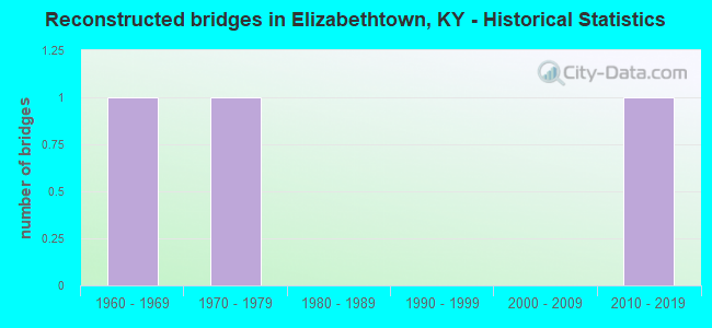
- Reconstructed bridges - Historical Statistics
- 11960-1969
- 11970-1979
- 01980-1989
- 01990-1999
- 02000-2009
- 12010-2019
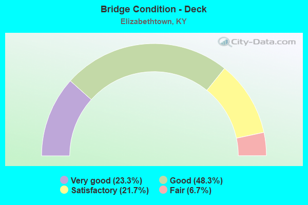
- Bridge Condition - Deck
- 23.3%Very good
- 48.3%Good
- 21.7%Satisfactory
- 6.7%Fair
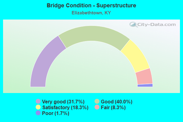
- Bridge Condition - Superstructure
- 31.7%Very good
- 40.0%Good
- 18.3%Satisfactory
- 8.3%Fair
- 1.7%Poor
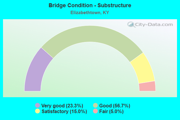
- Bridge Condition - Substructure
- 23.3%Very good
- 56.7%Good
- 15.0%Satisfactory
- 5.0%Fair
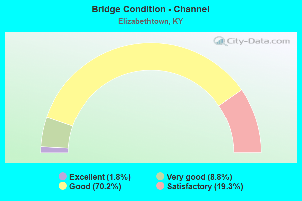
- Bridge Condition - Channel
- 1.8%Excellent
- 8.8%Very good
- 70.2%Good
- 19.3%Satisfactory
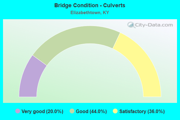
- Bridge Condition - Culverts
- 20.0%Very good
- 44.0%Good
- 36.0%Satisfactory
Find on map >> Show street view
Structure Number: 47B00011N, Location: .40 MI SOU. OF US 62 NTRC (Lat: 37.707500, Lng: -85.830556), Route carried "on" structure: Interstate 65, Year Built: 1956, Year Reconstructed: 1982, Status: Open, Structure Length: 0.76m (2.49ft), Average Daily Traffic: 52,382 (year 2020), Truck Traffic: 31%, Average Future Daily Traffic: 56,048 (year 2040), Design Load: HS 20, Features Intersected: TOWN BRANCH
Minimum Vertical Clearance: 30+ m (98+ ft), Kilometerpoint: 150.836, Lanes on structure: 6, Base Highway Network: Yes, Owner: State Highway Agency, Approaching Roadway Width: 50.0m (164.0ft), Skew: 24 degrees, Material/Design: Concrete, Design/Construction: Culvert, Number Of Spans In Main Unit: 1, Length of Maximum Span: 7.0m (23.0ft)
Condition: Channel: Good, Culverts: Good, Operating Rating: 99.8 metric tons, Method Used To Determine Operating Rating: Field evaluation and documented engineering judgment, Inventory Rating: 99.8 metric tons, Method Used To Determine Inventory Rating: Field evaluation and documented engineering judgment, Structural Evaluation: Better than present minimum criteria, Waterway Adequacy: Equal to present desirable criteria, Approach Roadway Alignment: Equal to present desirable criteria, Designated Inspection Frequency: Every 24 months, Inspection Date: November 2021
Find on map >> Show street view
Structure Number: 47B00021N, Location: .90 MI NOR. OF W KY PW UP (Lat: 37.685556, Lng: -85.842778), Route carried "on" structure: Interstate 65, Year Built: 1956, Status: Open, Structure Length: 1.95m (6.40ft), Average Daily Traffic: 55,357 (year 2020), Truck Traffic: 33%, Average Future Daily Traffic: 59,231 (year 2040), Features Intersected: VALLEY CREEK
Minimum Vertical Clearance: 30+ m (98+ ft), Kilometerpoint: 148.134, Lanes on structure: 6, Base Highway Network: Yes, Owner: State Highway Agency, Approaching Roadway Width: 26.8m (87.9ft), Skew: 23 degrees, Material/Design: Concrete, Design/Construction: Culvert, Number Of Spans In Main Unit: 3, Length of Maximum Span: 6.1m (20.0ft)
Condition: Channel: Good, Culverts: Satisfactory, Operating Rating: 54.4 metric tons, Method Used To Determine Operating Rating: Field evaluation and documented engineering judgment, Inventory Rating: 39.9 metric tons, Method Used To Determine Inventory Rating: Field evaluation and documented engineering judgment, Structural Evaluation: Equal to present minimum criteria, Waterway Adequacy: Equal to present desirable criteria, Approach Roadway Alignment: Better than present minimum criteria, Designated Inspection Frequency: Every 24 months, Inspection Date: November 2021
Find on map >> Show street view
Structure Number: 47B00025N, Location: .25 MI S.W. OF I-65 NTRCH (Lat: 37.711111, Lng: -85.834444), Route carried "on" structure: US 62, Year Built: 1959, Status: Posted for load, Structure Length: 1.52m (4.99ft), Average Daily Traffic: 24,650 (year 2019), Truck Traffic: 6%, Average Future Daily Traffic: 22,924 (year 2039), Design Load: H 15, Features Intersected: BUFFALO CREEK
Minimum Vertical Clearance: 30+ m (98+ ft), Kilometerpoint: 31.859, Lanes on structure: 4, Owner: State Highway Agency, Approaching Roadway Width: 22.6m (74.1ft), Skew: 24 degrees, Material/Design: Concrete, Design/Construction: Culvert, Number Of Spans In Main Unit: 2, Length of Maximum Span: 7.0m (23.0ft), Curb-To-Curb Width: 13.4m (44.0ft), Out-to-Out Width: 13.4m (44.0ft)
Condition: Channel: Satisfactory, Culverts: Satisfactory, Operating Rating: 39.0 metric tons, Method Used To Determine Operating Rating: Field evaluation and documented engineering judgment, Inventory Rating: 18.1 metric tons, Method Used To Determine Inventory Rating: Field evaluation and documented engineering judgment, Structural Evaluation: Meets minimum limits, Deck Geometry: High priority of replacement, Waterway Adequacy: Better than present minimum criteria, Approach Roadway Alignment: Equal to present desirable criteria, Bridge Posting: Required (Relationship of Operating Rating to Maximum Legal Load: > 39.9% below), Designated Inspection Frequency: Every 24 months, Inspection Date: November 2021
Find on map >> Show street view
Structure Number: 47B00026N, Location: ON LARUE - HARDIN CL (Lat: 37.624167, Lng: -85.800000), Route carried "on" structure: State highway 210, Year Built: 1968, Status: Posted for load, Structure Length: 3.47m (11.38ft), Average Daily Traffic: 2,670 (year 2018), Average Future Daily Traffic: 2,349 (year 2038), Design Load: H 20, Features Intersected: MIDDLE CRK
Minimum Vertical Clearance: 30+ m (98+ ft), Kilometerpoint: 6.841, Lanes on structure: 2, Owner: State Highway Agency, Approaching Roadway Width: 6.7m (22.0ft), Skew: 1 degrees, Material/Design: Concrete, Design/Construction: Tee Beam, Number Of Spans In Main Unit: 3, Length of Maximum Span: 10.7m (35.1ft), Curb or Sidewalk Widths: Left: 0.3m (1.0ft), Right: 0.3m (1.0ft), Curb-To-Curb Width: 9.1m (29.9ft), Out-to-Out Width: 10.0m (32.8ft)
Condition: Deck: Satisfactory, Superstructure: Good, Substructure: Satisfactory, Channel: Good, Operating Rating: 55.1 metric tons, Method Used To Determine Operating Rating: Load Factor (LF), Inventory Rating: 33.0 metric tons, Method Used To Determine Inventory Rating: Load Factor (LF), Structural Evaluation: Equal to present minimum criteria, Deck Geometry: Meets minimum limits, Waterway Adequacy: Equal to present minimum criteria, Approach Roadway Alignment: Better than present minimum criteria, Bridge Posting: Required (Relationship of Operating Rating to Maximum Legal Load: 10.0 - 19.9% below), Designated Inspection Frequency: Every 24 months, Inspection Date: November 2020, Deck Structure Type: Concrete Cast-file-Place, Wearing Surface/Protective System: Wearing Surface: Monolithic Concrete
Find on map >> Show street view
Structure Number: 47B00027N, Location: .95 MI S.E. OF JCT US 31W (Lat: 37.661944, Lng: -85.834444), Route carried "on" structure: State highway 210, Year Built: 1966, Status: Open, Structure Length: 0.79m (2.59ft), Average Daily Traffic: 6,337 (year 2019), Average Future Daily Traffic: 5,576 (year 2039), Features Intersected: UNNAMED STREAM
Minimum Vertical Clearance: 30+ m (98+ ft), Kilometerpoint: 1.654, Lanes on structure: 2, Owner: State Highway Agency, Approaching Roadway Width: 6.1m (20.0ft), Skew: 4 degrees, Material/Design: Concrete, Design/Construction: Culvert, Number Of Spans In Main Unit: 2, Length of Maximum Span: 3.4m (11.2ft), Out-to-Out Width: 14.6m (47.9ft)
Condition: Channel: Satisfactory, Culverts: Satisfactory, Operating Rating: 54.4 metric tons, Method Used To Determine Operating Rating: Field evaluation and documented engineering judgment, Inventory Rating: 39.9 metric tons, Method Used To Determine Inventory Rating: Field evaluation and documented engineering judgment, Structural Evaluation: Equal to present minimum criteria, Waterway Adequacy: Equal to present minimum criteria, Approach Roadway Alignment: Equal to present minimum criteria, Designated Inspection Frequency: Every 24 months, Inspection Date: November 2021
Find on map >> Show street view
Structure Number: 47B00031N, Location: 2.0 MI NOR. OF JCT KY 222 (Lat: 37.626389, Lng: -85.856667), Route carried "on" structure: US 31, Year Built: 1942, Status: Open, Structure Length: 1.01m (3.31ft), Average Daily Traffic: 3,502 (year 2019), Truck Traffic: 13%, Average Future Daily Traffic: 3,081 (year 2039), Design Load: H 15, Features Intersected: E RHUDES CREEK
Minimum Vertical Clearance: 30+ m (98+ ft), Kilometerpoint: 18.923, Lanes on structure: 2, Owner: State Highway Agency, Approaching Roadway Width: 7.9m (25.9ft), Material/Design: Concrete, Design/Construction: Culvert, Number Of Spans In Main Unit: 3, Length of Maximum Span: 3.0m (9.8ft)
Condition: Channel: Satisfactory, Culverts: Good, Operating Rating: 84.5 metric tons, Method Used To Determine Operating Rating: Load Factor (LF), Inventory Rating: 50.7 metric tons, Method Used To Determine Inventory Rating: Load Factor (LF), Structural Evaluation: Better than present minimum criteria, Waterway Adequacy: Better than present minimum criteria, Approach Roadway Alignment: Better than present minimum criteria, Designated Inspection Frequency: Every 24 months, Inspection Date: November 2021
Find on map >> Show street view
Structure Number: 47B00035N, Location: 2.0 MI NOR. OF KY 222 NTR (Lat: 37.627222, Lng: -85.861944), Route carried "on" structure: Interstate 65, Year Built: 1958, Status: Open, Structure Length: 0.94m (3.08ft), Average Daily Traffic: 40,384 (year 2020), Truck Traffic: 36%, Average Future Daily Traffic: 49,268 (year 2040), Design Load: H 15, Features Intersected: EAST RHUDES CREEK
Minimum Vertical Clearance: 30+ m (98+ ft), Kilometerpoint: 141.374, Lanes on structure: 6, Base Highway Network: Yes, Owner: State Highway Agency, Approaching Roadway Width: 40.8m (133.9ft), Material/Design: Concrete, Design/Construction: Culvert, Number Of Spans In Main Unit: 2, Length of Maximum Span: 4.3m (14.1ft)
Condition: Channel: Good, Culverts: Good, Operating Rating: 54.4 metric tons, Method Used To Determine Operating Rating: Field evaluation and documented engineering judgment, Inventory Rating: 39.9 metric tons, Method Used To Determine Inventory Rating: Field evaluation and documented engineering judgment, Structural Evaluation: Better than present minimum criteria, Waterway Adequacy: Equal to present desirable criteria, Approach Roadway Alignment: Equal to present desirable criteria, Designated Inspection Frequency: Every 24 months, Inspection Date: November 2021
Find on map >> Show street view
Structure Number: 47B00054N, Location: 2.3 MI NOR. OF JCT KY 222 (Lat: 37.629444, Lng: -85.887500), Route carried "on" structure: State highway 1136, Year Built: 1965, Status: Open, Structure Length: 0.76m (2.49ft), Average Daily Traffic: 1,999 (year 2020), Average Future Daily Traffic: 1,759 (year 2040), Design Load: H 20, Features Intersected: E RHUDES CREEK
Minimum Vertical Clearance: 30+ m (98+ ft), Kilometerpoint: 10.142, Lanes on structure: 2, Owner: State Highway Agency, Approaching Roadway Width: 6.1m (20.0ft), Skew: 4 degrees, Material/Design: Concrete, Design/Construction: Culvert, Number Of Spans In Main Unit: 1, Length of Maximum Span: 7.0m (23.0ft)
Condition: Channel: Good, Culverts: Good, Operating Rating: 54.4 metric tons, Method Used To Determine Operating Rating: Field evaluation and documented engineering judgment, Inventory Rating: 40.8 metric tons, Method Used To Determine Inventory Rating: Field evaluation and documented engineering judgment, Structural Evaluation: Better than present minimum criteria, Waterway Adequacy: Better than present minimum criteria, Approach Roadway Alignment: Equal to present minimum criteria, Designated Inspection Frequency: Every 24 months, Inspection Date: November 2020
Find on map >> Show street view
Structure Number: 47B00069N, Location: 1.2 MI EAST OF JCT KY 251 (Lat: 37.777500, Lng: -85.836111), Route carried "on" structure: State highway 434, Year Built: 1944, Status: Open, Structure Length: 0.79m (2.59ft), Average Daily Traffic: 1,463 (year 2019), Average Future Daily Traffic: 1,287 (year 2039), Design Load: H 15, Features Intersected: CEDAR CREEK
Minimum Vertical Clearance: 30+ m (98+ ft), Kilometerpoint: 6.968, Lanes on structure: 2, Owner: State Highway Agency, Approaching Roadway Width: 6.7m (22.0ft), Material/Design: Concrete, Design/Construction: Culvert, Number Of Spans In Main Unit: 2, Length of Maximum Span: 3.0m (9.8ft)
Condition: Channel: Good, Culverts: Satisfactory, Operating Rating: 54.4 metric tons, Method Used To Determine Operating Rating: Field evaluation and documented engineering judgment, Inventory Rating: 39.9 metric tons, Method Used To Determine Inventory Rating: Field evaluation and documented engineering judgment, Structural Evaluation: Equal to present minimum criteria, Waterway Adequacy: Better than present minimum criteria, Approach Roadway Alignment: Better than present minimum criteria, Designated Inspection Frequency: Every 24 months, Inspection Date: November 2021
Find on map >> Show street view
Structure Number: 47B00082N, Location: 1.0 MI W Of U.S. 31W BYP (Lat: 37.694167, Lng: -85.896667), Route carried "on" structure: State highway 1357, Year Built: 1952, Status: Posted for load, Structure Length: 2.01m (6.59ft), Average Daily Traffic: 5,828 (year 2019), Truck Traffic: 6%, Average Future Daily Traffic: 5,420 (year 2039), Design Load: H 15, Features Intersected: BILLYS CREEK, Facility Carried by Structure: ST. JOHN ROAD
Minimum Vertical Clearance: 30+ m (98+ ft), Kilometerpoint: 24.790, Lanes on structure: 2, Owner: State Highway Agency, Approaching Roadway Width: 5.5m (18.0ft), Material/Design: Concrete, Design/Construction: Tee Beam, Number Of Spans In Main Unit: 2, Length of Maximum Span: 9.1m (29.9ft), Curb or Sidewalk Widths: Left: 0.6m (2.0ft), Right: 0.6m (2.0ft), Curb-To-Curb Width: 6.1m (20.0ft), Out-to-Out Width: 6.7m (22.0ft)
Condition: Deck: Fair, Superstructure: Satisfactory, Substructure: Satisfactory, Channel: Good, Operating Rating: 32.5 metric tons, Method Used To Determine Operating Rating: Load Factor (LF), Inventory Rating: 19.5 metric tons, Method Used To Determine Inventory Rating: Load Factor (LF), Structural Evaluation: Meets minimum limits, Deck Geometry: High priority of replacement, Waterway Adequacy: Equal to present minimum criteria, Approach Roadway Alignment: Somewhat better than minimum adequacy, Bridge Posting: Required (Relationship of Operating Rating to Maximum Legal Load: > 39.9% below), Length Of Structure Improvement: 0.20m (0.66ft), Designated Inspection Frequency: Every 24 months, Inspection Date: November 2020, Bridge Improvement Cost: $182,000, Total Project Cost: $181,000, Deck Structure Type: Concrete Cast-file-Place, Wearing Surface/Protective System: Wearing Surface: Bituminous
Find on map >> Show street view
Structure Number: 47B00090N, Location: 2.2 MI SW OF JCT US 62 (Lat: 37.645278, Lng: -85.915000), Route carried "on" structure: State highway 1904, Year Built: 1962, Status: Posted for load, Structure Length: 8.69m (28.51ft), Average Daily Traffic: 2,773 (year 2019), Average Future Daily Traffic: 2,412 (year 2039), Design Load: H 15, Features Intersected: WESTERN KENTUCKY PARKWAY
Minimum Vertical Clearance: 30+ m (98+ ft), Kilometerpoint: 3.959, Lanes on structure: 2, Lanes under structure: 4, Owner: State Highway Agency, Approaching Roadway Width: 6.7m (22.0ft), Skew: 4 degrees, Material/Design: Concrete continuous, Design/Construction: Tee Beam, Number Of Spans In Main Unit: 4, Length of Maximum Span: 23.8m (78.1ft), Curb or Sidewalk Widths: Left: 0.5m (1.6ft), Right: 0.5m (1.6ft), Curb-To-Curb Width: 7.3m (24.0ft), Out-to-Out Width: 8.2m (26.9ft)
Condition: Deck: Fair, Superstructure: Fair, Substructure: Good, Operating Rating: 32.7 metric tons, Method Used To Determine Operating Rating: Load Factor (LF), Inventory Rating: 19.7 metric tons, Method Used To Determine Inventory Rating: Load Factor (LF), Structural Evaluation: Somewhat better than minimum adequacy, Deck Geometry: High priority of replacement, Underclear: Equal to present minimum criteria, Approach Roadway Alignment: Somewhat better than minimum adequacy, Bridge Posting: Required (Relationship of Operating Rating to Maximum Legal Load: > 39.9% below), Designated Inspection Frequency: Every 24 months, Inspection Date: November 2020, Deck Structure Type: Concrete Cast-file-Place, Wearing Surface/Protective System: Wearing Surface: Bituminous
Find on map >> Show street view
Structure Number: 47B00092L, Location: WBL 3 MI W-US31W BYP NTRC (Lat: 37.649167, Lng: -85.902778), Route carried "on" structure: State highway 9001, Year Built: 1962, Status: Open, Structure Length: 5.27m (17.29ft), Average Daily Traffic: 6,304 (year 2020), Truck Traffic: 29%, Average Future Daily Traffic: 5,925 (year 2040), Design Load: HS 20, Features Intersected: CSX RR-GAITHER STA. RD, Facility Carried by Structure: WESTERN KENTUCKY P
Minimum Vertical Clearance: 30+ m (98+ ft), Kilometerpoint: 213.365, Lanes on structure: 2, Lanes under structure: 2, Base Highway Network: Yes, Owner: State Highway Agency, Approaching Roadway Width: 15.2m (49.9ft), Skew: 11 degrees, Material/Design: Concrete, Design/Construction: Tee Beam, Number Of Spans In Main Unit: 4, Length of Maximum Span: 12.2m (40.0ft), Curb-To-Curb Width: 9.1m (29.9ft), Out-to-Out Width: 10.1m (33.1ft)
Condition: Deck: Good, Superstructure: Satisfactory, Substructure: Fair, Operating Rating: 81.3 metric tons, Method Used To Determine Operating Rating: Load Factor (LF), Inventory Rating: 48.7 metric tons, Method Used To Determine Inventory Rating: Load Factor (LF), Structural Evaluation: Somewhat better than minimum adequacy, Deck Geometry: Meets minimum limits, Underclear: Better than present minimum criteria, Approach Roadway Alignment: Equal to present minimum criteria, Length Of Structure Improvement: 0.53m (1.74ft), Designated Inspection Frequency: Every 24 months, Inspection Date: November 2020, Bridge Improvement Cost: $714,000, Total Project Cost: $713,000, Deck Structure Type: Concrete Cast-file-Place, Wearing Surface/Protective System: Wearing Surface: Latex Concrete
Find on map >> Show street view
Structure Number: 47B00092R, Location: EBL 3 MI W-US31W BYP NTRC (Lat: 37.648889, Lng: -85.902778), Route carried "on" structure: State highway 9001, Year Built: 1962, Status: Open, Structure Length: 5.27m (17.29ft), Average Daily Traffic: 6,304 (year 2020), Truck Traffic: 29%, Average Future Daily Traffic: 5,925 (year 2040), Design Load: HS 20, Features Intersected: CSX RR-GAITHER STA. RD
Minimum Vertical Clearance: 30+ m (98+ ft), Kilometerpoint: 213.357, Lanes on structure: 2, Lanes under structure: 2, Base Highway Network: Yes, Owner: State Highway Agency, Approaching Roadway Width: 15.2m (49.9ft), Skew: 11 degrees, Material/Design: Concrete, Design/Construction: Tee Beam, Number Of Spans In Main Unit: 4, Length of Maximum Span: 12.2m (40.0ft), Curb-To-Curb Width: 9.1m (29.9ft), Out-to-Out Width: 10.1m (33.1ft)
Condition: Deck: Good, Superstructure: Good, Substructure: Fair, Operating Rating: 81.3 metric tons, Method Used To Determine Operating Rating: Load Factor (LF), Inventory Rating: 48.7 metric tons, Method Used To Determine Inventory Rating: Load Factor (LF), Structural Evaluation: Somewhat better than minimum adequacy, Deck Geometry: Meets minimum limits, Underclear: Better than present minimum criteria, Approach Roadway Alignment: Equal to present minimum criteria, Length Of Structure Improvement: 0.53m (1.74ft), Designated Inspection Frequency: Every 24 months, Inspection Date: November 2020, Bridge Improvement Cost: $714,000, Total Project Cost: $713,000, Deck Structure Type: Concrete Cast-file-Place, Wearing Surface/Protective System: Wearing Surface: Latex Concrete
Find on map >> Show street view
Structure Number: 47B00093L, Location: WBL .5 MI E-KY 1904 UP (Lat: 37.648889, Lng: -85.905556), Route carried "on" structure: State highway 9001, Year Built: 1962, Status: Open, Structure Length: 6.40m (21.00ft), Average Daily Traffic: 6,304 (year 2020), Truck Traffic: 29%, Average Future Daily Traffic: 5,925 (year 2040), Design Load: HS 20, Features Intersected: VALLEY CREEK, Facility Carried by Structure: WESTERN KENTUCKY P
Minimum Vertical Clearance: 30+ m (98+ ft), Kilometerpoint: 213.108, Lanes on structure: 2, Base Highway Network: Yes, Owner: State Highway Agency, Approaching Roadway Width: 15.2m (49.9ft), Skew: 10 degrees, Material/Design: Concrete continuous, Design/Construction: Tee Beam, Number Of Spans In Main Unit: 3, Length of Maximum Span: 24.4m (80.1ft), Curb or Sidewalk Widths: Left: 0.5m (1.6ft), Right: 0.5m (1.6ft), Curb-To-Curb Width: 9.1m (29.9ft), Out-to-Out Width: 10.7m (35.1ft)
Condition: Deck: Good, Superstructure: Good, Substructure: Good, Channel: Good, Operating Rating: 65.8 metric tons, Method Used To Determine Operating Rating: Load Factor (LF), Inventory Rating: 39.5 metric tons, Method Used To Determine Inventory Rating: Load Factor (LF), Structural Evaluation: Better than present minimum criteria, Deck Geometry: Meets minimum limits, Waterway Adequacy: Equal to present desirable criteria, Approach Roadway Alignment: Better than present minimum criteria, Designated Inspection Frequency: Every 24 months, Inspection Date: November 2021, Deck Structure Type: Concrete Cast-file-Place, Wearing Surface/Protective System: Wearing Surface: Latex Concrete
Find on map >> Show street view
Structure Number: 47B00093R, Location: EBL .5 MI E-KY 1904 UP (Lat: 37.648611, Lng: -85.905556), Route carried "on" structure: State highway 9001, Year Built: 1962, Status: Open, Structure Length: 6.40m (21.00ft), Average Daily Traffic: 6,304 (year 2020), Truck Traffic: 29%, Average Future Daily Traffic: 5,925 (year 2040), Design Load: HS 20, Features Intersected: VALLEY CREEK
Minimum Vertical Clearance: 30+ m (98+ ft), Kilometerpoint: 213.105, Lanes on structure: 2, Base Highway Network: Yes, Owner: State Highway Agency, Approaching Roadway Width: 15.2m (49.9ft), Skew: 10 degrees, Material/Design: Concrete continuous, Design/Construction: Tee Beam, Number Of Spans In Main Unit: 3, Length of Maximum Span: 24.4m (80.1ft), Curb or Sidewalk Widths: Left: 0.5m (1.6ft), Right: 0.5m (1.6ft), Curb-To-Curb Width: 9.1m (29.9ft), Out-to-Out Width: 10.7m (35.1ft)
Condition: Deck: Good, Superstructure: Good, Substructure: Good, Channel: Good, Operating Rating: 65.8 metric tons, Method Used To Determine Operating Rating: Load Factor (LF), Inventory Rating: 39.5 metric tons, Method Used To Determine Inventory Rating: Load Factor (LF), Structural Evaluation: Better than present minimum criteria, Deck Geometry: Meets minimum limits, Waterway Adequacy: Equal to present desirable criteria, Approach Roadway Alignment: Better than present minimum criteria, Designated Inspection Frequency: Every 24 months, Inspection Date: November 2021, Deck Structure Type: Concrete Cast-file-Place, Wearing Surface/Protective System: Wearing Surface: Latex Concrete
Find on map >> Show street view
Structure Number: 47B00100N, Location: .10 MI EAST OF COURTHOUSE (Lat: 37.691944, Lng: -85.856389), Route carried "on" structure: US 31, Year Built: 1936, Status: Open, Structure Length: 2.62m (8.60ft), Average Daily Traffic: 13,629 (year 2019), Truck Traffic: 18%, Average Future Daily Traffic: 12,674 (year 2039), Design Load: H 15, Features Intersected: VALLEY CREEK
Minimum Vertical Clearance: 30+ m (98+ ft), Kilometerpoint: 26.536, Lanes on structure: 4, Owner: State Highway Agency, Approaching Roadway Width: 14.6m (47.9ft), Material/Design: Concrete, Design/Construction: Tee Beam, Number Of Spans In Main Unit: 2, Length of Maximum Span: 12.2m (40.0ft), Curb or Sidewalk Widths: Left: 1.5m (4.9ft), Right: 1.5m (4.9ft), Curb-To-Curb Width: 12.2m (40.0ft), Out-to-Out Width: 15.8m (51.8ft)
Condition: Deck: Satisfactory, Superstructure: Satisfactory, Substructure: Fair, Channel: Satisfactory, Operating Rating: 59.5 metric tons, Method Used To Determine Operating Rating: Load Factor (LF), Inventory Rating: 35.7 metric tons, Method Used To Determine Inventory Rating: Load Factor (LF), Structural Evaluation: Somewhat better than minimum adequacy, Deck Geometry: High priority of replacement, Waterway Adequacy: Better than present minimum criteria, Approach Roadway Alignment: Equal to present minimum criteria, Length Of Structure Improvement: 0.26m (0.85ft), Designated Inspection Frequency: Every 24 months, Inspection Date: November 2020, Bridge Improvement Cost: $538,000, Total Project Cost: $537,000, Deck Structure Type: Concrete Cast-file-Place, Wearing Surface/Protective System: Wearing Surface: Latex Concrete
Find on map >> Show street view
Structure Number: 47B00104N, Location: .20 MI EAST OF US 31W BP (Lat: 37.690556, Lng: -85.863611), Route carried "on" structure: US 62, Year Built: 1934, Year Reconstructed: 1974, Status: Open, Structure Length: 3.02m (9.91ft), Average Daily Traffic: 13,692 (year 2019), Truck Traffic: 10%, Average Future Daily Traffic: 12,733 (year 2039), Design Load: HS 20, Features Intersected: VALLEY CREEK
Minimum Vertical Clearance: 30+ m (98+ ft), Kilometerpoint: 28.373, Lanes on structure: 4, Owner: State Highway Agency, Approaching Roadway Width: 17.7m (58.1ft), Skew: 10 degrees, Material/Design: Concrete, Design/Construction: Tee Beam, Number Of Spans In Main Unit: 3, Length of Maximum Span: 9.1m (29.9ft), Curb or Sidewalk Widths: Left: 1.2m (3.9ft), Right: 1.2m (3.9ft), Curb-To-Curb Width: 17.7m (58.1ft), Out-to-Out Width: 20.7m (67.9ft)
Condition: Deck: Good, Superstructure: Satisfactory, Substructure: Satisfactory, Channel: Good, Operating Rating: 64.7 metric tons, Method Used To Determine Operating Rating: Load Factor (LF), Inventory Rating: 38.8 metric tons, Method Used To Determine Inventory Rating: Load Factor (LF), Structural Evaluation: Equal to present minimum criteria, Deck Geometry: Somewhat better than minimum adequacy, Waterway Adequacy: Better than present minimum criteria, Approach Roadway Alignment: Better than present minimum criteria, Designated Inspection Frequency: Every 24 months, Inspection Date: November 2020, Deck Structure Type: Concrete Cast-file-Place, Wearing Surface/Protective System: Wearing Surface: Monolithic Concrete
Find on map >> Show street view
Structure Number: 47B00105N, Location: .10 MI NOR. OF JCT KY 251 (Lat: 37.692778, Lng: -85.873056), Route carried "on" structure: Bypass US 31, Year Built: 1974, Status: Open, Structure Length: 0.94m (3.08ft), Average Daily Traffic: 23,019 (year 2020), Truck Traffic: 10%, Average Future Daily Traffic: 21,637 (year 2040), Design Load: HS 20+Mod, Features Intersected: FREEMAN CREEK
Minimum Vertical Clearance: 30+ m (98+ ft), Kilometerpoint: 2.343, Lanes on structure: 4, Base Highway Network: Yes, Owner: State Highway Agency, Approaching Roadway Width: 29.3m (96.1ft), Skew: 13 degrees, Material/Design: Concrete, Design/Construction: Culvert, Number Of Spans In Main Unit: 2, Length of Maximum Span: 4.3m (14.1ft)
Condition: Channel: Satisfactory, Culverts: Good, Operating Rating: 66.6 metric tons, Method Used To Determine Operating Rating: Load Factor (LF), Inventory Rating: 40.2 metric tons, Method Used To Determine Inventory Rating: Load Factor (LF), Structural Evaluation: Better than present minimum criteria, Waterway Adequacy: Better than present minimum criteria, Approach Roadway Alignment: Better than present minimum criteria, Designated Inspection Frequency: Every 24 months, Inspection Date: November 2021
Find on map >> Show street view
Structure Number: 47B00106N, Location: .15 MI NOR. OF US 62 OP (Lat: 37.690278, Lng: -85.869444), Route carried "on" structure: Bypass US 31, Year Built: 1974, Status: Posted for load, Structure Length: 0.98m (3.22ft), Average Daily Traffic: 25,226 (year 2018), Truck Traffic: 9%, Average Future Daily Traffic: 23,712 (year 2038), Design Load: HS 20+Mod, Features Intersected: VALLEY CREEK
Minimum Vertical Clearance: 30+ m (98+ ft), Kilometerpoint: 1.926, Lanes on structure: 4, Base Highway Network: Yes, Owner: State Highway Agency, Approaching Roadway Width: 36.6m (120.1ft), Skew: 11 degrees, Material/Design: Concrete, Design/Construction: Culvert, Number Of Spans In Main Unit: 2, Length of Maximum Span: 4.3m (14.1ft)
Condition: Channel: Satisfactory, Culverts: Satisfactory, Operating Rating: 39.0 metric tons, Method Used To Determine Operating Rating: Field evaluation and documented engineering judgment, Inventory Rating: 18.1 metric tons, Method Used To Determine Inventory Rating: Field evaluation and documented engineering judgment, Structural Evaluation: Meets minimum limits, Waterway Adequacy: Equal to present desirable criteria, Approach Roadway Alignment: Better than present minimum criteria, Bridge Posting: Required (Relationship of Operating Rating to Maximum Legal Load: > 39.9% below), Designated Inspection Frequency: Every 24 months, Inspection Date: November 2020
Find on map >> Show street view
Structure Number: 47B00107L, Location: .5 MI N OF WK PKY NTRCH (Lat: 37.688611, Lng: -85.866389), Route carried "on" structure: Bypass US 31, Year Built: 1974, Status: Open, Structure Length: 14.30m (46.92ft), Average Daily Traffic: 12,613 (year 2018), Truck Traffic: 9%, Average Future Daily Traffic: 11,856 (year 2038), Design Load: HS 20+Mod, Features Intersected: CSX RR - P&L RR - US 62
Minimum Vertical Clearance: 30+ m (98+ ft), Kilometerpoint: 1.580, Lanes on structure: 2, Lanes under structure: 5, Base Highway Network: Yes, Owner: State Highway Agency, Approaching Roadway Width: 18.3m (60.0ft), Skew: 12 degrees, Material/Design: Steel, Design/Construction: Stringer/Multi-beam, Number Of Spans In Main Unit: 6, Length of Maximum Span: 36.6m (120.1ft), Curb-To-Curb Width: 16.0m (52.5ft), Out-to-Out Width: 16.9m (55.4ft)
Condition: Deck: Good, Superstructure: Satisfactory, Substructure: Good, Operating Rating: 55.8 metric tons, Method Used To Determine Operating Rating: Load Factor (LF), Inventory Rating: 33.5 metric tons, Method Used To Determine Inventory Rating: Load Factor (LF), Structural Evaluation: Equal to present minimum criteria, Deck Geometry: Superior to present desirable criteria, Underclear: Somewhat better than minimum adequacy, Approach Roadway Alignment: Better than present minimum criteria, Length Of Structure Improvement: 1.43m (4.69ft), Designated Inspection Frequency: Every 24 months, Inspection Date: November 2021, Bridge Improvement Cost: $3,254,000, Total Project Cost: $3,253,000, Deck Structure Type: Concrete Cast-file-Place, Wearing Surface/Protective System: Wearing Surface: Latex Concrete
Find on map >> Show street view
Structure Number: 47B00108L, Location: OVER WKYPW INTERCHANGE (Lat: 37.679444, Lng: -85.861111), Route carried "on" structure: Bypass US 31, Year Built: 1974, Status: Open, Structure Length: 7.01m (23.00ft), Average Daily Traffic: 10,901 (year 2020), Truck Traffic: 9%, Average Future Daily Traffic: 10,246 (year 2040), Design Load: HS 20+Mod, Features Intersected: WESTERN KENTUCKY PARKWAY
Minimum Vertical Clearance: 30+ m (98+ ft), Kilometerpoint: 0.431, Lanes on structure: 2, Lanes under structure: 4, Base Highway Network: Yes, Owner: State Highway Agency, Approaching Roadway Width: 14.6m (47.9ft), Skew: 30 degrees, Material/Design: Prestressed concrete continuous, Design/Construction: Stringer/Multi-beam, Number Of Spans In Main Unit: 4, Length of Maximum Span: 21.0m (68.9ft), Curb-To-Curb Width: 14.6m (47.9ft), Out-to-Out Width: 15.8m (51.8ft)
Condition: Deck: Good, Superstructure: Good, Substructure: Good, Operating Rating: 88.6 metric tons, Method Used To Determine Operating Rating: Load Factor (LF), Inventory Rating: 53.2 metric tons, Method Used To Determine Inventory Rating: Load Factor (LF), Structural Evaluation: Better than present minimum criteria, Deck Geometry: Superior to present desirable criteria, Underclear: High priority of corrective action, Approach Roadway Alignment: Better than present minimum criteria, Length Of Structure Improvement: 0.52m (1.71ft), Designated Inspection Frequency: Every 24 months, Inspection Date: November 2020, Bridge Improvement Cost: $1,009,000, Total Project Cost: $1,009,000, Deck Structure Type: Concrete Cast-file-Place, Wearing Surface/Protective System: Wearing Surface: Latex Concrete
Find on map >> Show street view
Structure Number: 47B00109N, Location: OVR US31WBP-.1 MI W US31W (Lat: 37.717778, Lng: -85.882222), Route carried "on" structure: City street 1193, Year Built: 1974, Status: Open, Structure Length: 7.74m (25.39ft), Average Daily Traffic: 4,840 (year 2019), Average Future Daily Traffic: 4,501 (year 2039), Design Load: HS 20+Mod, Features Intersected: US 31W BYPASS @ 3.589, Facility Carried by Structure: WOODLAND DR
Minimum Vertical Clearance: 30+ m (98+ ft), Kilometerpoint: 1.133, Lanes on structure: 2, Lanes under structure: 4, Owner: State Highway Agency, Approaching Roadway Width: 14.6m (47.9ft), Skew: 12 degrees, Material/Design: Prestressed concrete continuous, Design/Construction: Stringer/Multi-beam, Number Of Spans In Main Unit: 4, Length of Maximum Span: 22.3m (73.2ft), Curb or Sidewalk Widths: Left: 0.2m (0.7ft), Right: 0.2m (0.7ft), Curb-To-Curb Width: 9.6m (31.5ft), Out-to-Out Width: 11.3m (37.1ft)
Condition: Deck: Fair, Superstructure: Good, Substructure: Good, Operating Rating: 94.6 metric tons, Method Used To Determine Operating Rating: Load Factor (LF), Inventory Rating: 56.8 metric tons, Method Used To Determine Inventory Rating: Load Factor (LF), Structural Evaluation: Better than present minimum criteria, Deck Geometry: Meets minimum limits, Underclear: Somewhat better than minimum adequacy, Approach Roadway Alignment: Better than present minimum criteria, Designated Inspection Frequency: Every 24 months, Inspection Date: November 2021, Deck Structure Type: Concrete Cast-file-Place, Wearing Surface/Protective System: Wearing Surface: Monolithic Concrete
Find on map >> Show street view
Structure Number: 47B00119L, Location: 3.4 MI. N OF US 62 (Lat: 37.764167, Lng: -85.793333), Route carried "on" structure: Interstate 65, Year Built: 1982, Status: Open, Structure Length: 1.89m (6.20ft), Average Daily Traffic: 24,260 (year 2020), Truck Traffic: 31%, Average Future Daily Traffic: 29,597 (year 2040), Design Load: HS 20, Features Intersected: CLEAR CREEK
Minimum Vertical Clearance: 30+ m (98+ ft), Kilometerpoint: 158.606, Lanes on structure: 3, Base Highway Network: Yes, Owner: State Highway Agency, Approaching Roadway Width: 24.4m (80.1ft), Skew: 12 degrees, Material/Design: Prestressed concrete, Design/Construction: Stringer/Multi-beam, Number Of Spans In Main Unit: 1, Length of Maximum Span: 17.1m (56.1ft), Curb-To-Curb Width: 17.1m (56.1ft), Out-to-Out Width: 18.2m (59.7ft)
Condition: Deck: Good, Superstructure: Good, Substructure: Good, Channel: Good, Operating Rating: 66.3 metric tons, Method Used To Determine Operating Rating: Load Factor (LF), Inventory Rating: 39.8 metric tons, Method Used To Determine Inventory Rating: Load Factor (LF), Structural Evaluation: Better than present minimum criteria, Deck Geometry: Equal to present minimum criteria, Waterway Adequacy: Equal to present desirable criteria, Approach Roadway Alignment: Better than present minimum criteria, Designated Inspection Frequency: Every 24 months, Inspection Date: November 2021, Deck Structure Type: Concrete Cast-file-Place, Wearing Surface/Protective System: Wearing Surface: Integral Concrete, Deck Protection: Epoxy Coated Reinforcing
Find on map >> Show street view
Structure Number: 47B00119R, Location: 3.4 MI. N OF US 62 (Lat: 37.764167, Lng: -85.793056), Route carried "on" structure: Interstate 65, Year Built: 1982, Status: Open, Structure Length: 1.89m (6.20ft), Average Daily Traffic: 24,260 (year 2020), Truck Traffic: 31%, Average Future Daily Traffic: 29,597 (year 2040), Design Load: HS 20, Features Intersected: CLEAR CREEK
Minimum Vertical Clearance: 30+ m (98+ ft), Kilometerpoint: 158.627, Lanes on structure: 3, Base Highway Network: Yes, Owner: State Highway Agency, Approaching Roadway Width: 24.4m (80.1ft), Skew: 12 degrees, Material/Design: Prestressed concrete, Design/Construction: Stringer/Multi-beam, Number Of Spans In Main Unit: 1, Length of Maximum Span: 17.1m (56.1ft), Curb-To-Curb Width: 17.1m (56.1ft), Out-to-Out Width: 18.1m (59.4ft)
Condition: Deck: Good, Superstructure: Good, Substructure: Good, Channel: Good, Operating Rating: 66.3 metric tons, Method Used To Determine Operating Rating: Load Factor (LF), Inventory Rating: 39.8 metric tons, Method Used To Determine Inventory Rating: Load Factor (LF), Structural Evaluation: Better than present minimum criteria, Deck Geometry: Equal to present minimum criteria, Waterway Adequacy: Equal to present desirable criteria, Approach Roadway Alignment: Better than present minimum criteria, Designated Inspection Frequency: Every 24 months, Inspection Date: November 2021, Deck Structure Type: Concrete Cast-file-Place, Wearing Surface/Protective System: Wearing Surface: Integral Concrete, Deck Protection: Epoxy Coated Reinforcing
Find on map >> Show street view
Structure Number: 47B00122N, Location: .5 MI NW OF JCT US 62 (Lat: 37.728056, Lng: -85.819722), Route carried "on" structure: County highway 1016, Year Built: 1983, Status: Open, Structure Length: 9.57m (31.40ft), Average Daily Traffic: 1,853 (year 2009), Average Future Daily Traffic: 1,741 (year 2029), Design Load: HS 20, Features Intersected: I-65, Facility Carried by Structure: Tunnel Hill Rd
Minimum Vertical Clearance: 30+ m (98+ ft), Kilometerpoint: 1.069, Lanes on structure: 2, Lanes under structure: 6, Owner: State Highway Agency, Approaching Roadway Width: 12.8m (42.0ft), Skew: 2 degrees, Material/Design: Steel continuous, Design/Construction: Stringer/Multi-beam, Number Of Spans In Main Unit: 2, Number Of Approach Spans: 2, Length of Maximum Span: 34.1m (111.9ft), Curb-To-Curb Width: 10.4m (34.1ft), Out-to-Out Width: 11.3m (37.1ft)
Condition: Deck: Satisfactory, Superstructure: Satisfactory, Substructure: Good, Operating Rating: 73.8 metric tons, Method Used To Determine Operating Rating: Load Factor (LF), Inventory Rating: 44.3 metric tons, Method Used To Determine Inventory Rating: Load Factor (LF), Structural Evaluation: Equal to present minimum criteria, Deck Geometry: Equal to present minimum criteria, Underclear: Equal to present minimum criteria, Approach Roadway Alignment: Equal to present minimum criteria, Designated Inspection Frequency: Every 24 months, Inspection Date: November 2020, Deck Structure Type: Concrete Cast-file-Place, Wearing Surface/Protective System: Wearing Surface: Monolithic Concrete, Deck Protection: Epoxy Coated Reinforcing
Find on map >> Show street view
Structure Number: 47B00123N, Location: 3.8 MI.NOR. OF US 62 NTRC (Lat: 37.767222, Lng: -85.791944), Route carried "on" structure: Interstate 65, Year Built: 1983, Status: Open, Structure Length: 0.76m (2.49ft), Average Daily Traffic: 48,519 (year 2020), Truck Traffic: 31%, Average Future Daily Traffic: 59,193 (year 2040), Design Load: H 15, Features Intersected: CLEAR CREEK
Minimum Vertical Clearance: 30+ m (98+ ft), Kilometerpoint: 158.985, Lanes on structure: 6, Base Highway Network: Yes, Owner: State Highway Agency, Approaching Roadway Width: 54.9m (180.1ft), Skew: 24 degrees, Material/Design: Concrete, Design/Construction: Culvert, Number Of Spans In Main Unit: 2, Length of Maximum Span: 3.7m (12.1ft)
Condition: Channel: Good, Culverts: Satisfactory, Operating Rating: 40.2 metric tons, Method Used To Determine Operating Rating: Load and Resistance Factor Rating (LRFR) rating reported by rating factor(RF) method using HL-93 loadings, Inventory Rating: 31.1 metric tons, Method Used To Determine Inventory Rating: Load and Resistance Factor Rating (LRFR) rating reported by rating factor(RF) method using HL-93 loadings, Structural Evaluation: Equal to present minimum criteria, Waterway Adequacy: Equal to present desirable criteria, Approach Roadway Alignment: Better than present minimum criteria, Designated Inspection Frequency: Every 24 months, Inspection Date: November 2021
Find on map >> Show street view
Structure Number: 47B00124N, Location: .21 MI N OF W.KY.PKY NTRC (Lat: 37.678056, Lng: -85.847500), Route carried "on" structure: Ramp Interstate 65, Year Built: 1983, Status: Open, Structure Length: 6.46m (21.19ft), Average Daily Traffic: 55,357 (year 2020), Truck Traffic: 33%, Average Future Daily Traffic: 59,231 (year 2040), Design Load: HS 20, Features Intersected: US 31W (UNDER S.B.CONNEC
Minimum Vertical Clearance: 30+ m (98+ ft), Kilometerpoint: 147.136, Lanes on structure: 1, Lanes under structure: 4, Owner: State Highway Agency, Approaching Roadway Width: 7.9m (25.9ft), Material/Design: Steel, Design/Construction: Stringer/Multi-beam, Number Of Spans In Main Unit: 3, Length of Maximum Span: 31.7m (104.0ft), Curb-To-Curb Width: 7.9m (25.9ft), Out-to-Out Width: 12.8m (42.0ft)
Condition: Deck: Good, Superstructure: Good, Substructure: Good, Operating Rating: 58.0 metric tons, Method Used To Determine Operating Rating: Load Factor (LF), Inventory Rating: 34.7 metric tons, Method Used To Determine Inventory Rating: Load Factor (LF), Structural Evaluation: Better than present minimum criteria, Deck Geometry: Equal to present desirable criteria, Underclear: Better than present minimum criteria, Approach Roadway Alignment: Better than present minimum criteria, Length Of Structure Improvement: 0.65m (2.13ft), Designated Inspection Frequency: Every 24 months, Inspection Date: November 2020, Bridge Improvement Cost: $1,113,000, Total Project Cost: $1,113,000, Deck Structure Type: Concrete Cast-file-Place, Wearing Surface/Protective System: Wearing Surface: Latex Concrete, Deck Protection: Epoxy Coated Reinforcing
Find on map >> Show street view
Structure Number: 47B00125L, Location: .2 MI N OF .KY.PKY NTRCH (Lat: 37.679167, Lng: -85.846111), Route carried "on" structure: Interstate 65, Year Built: 1983, Status: Open, Structure Length: 8.47m (27.79ft), Average Daily Traffic: 27,679 (year 2020), Truck Traffic: 33%, Average Future Daily Traffic: 29,616 (year 2040), Design Load: HS 20, Features Intersected: CSX RAILROAD& HAWKINS DR
Minimum Vertical Clearance: 30+ m (98+ ft), Kilometerpoint: 147.342, Lanes on structure: 3, Lanes under structure: 2, Base Highway Network: Yes, Owner: State Highway Agency, Approaching Roadway Width: 23.5m (77.1ft), Skew: 10 degrees, Material/Design: Prestressed concrete continuous, Design/Construction: Stringer/Multi-beam, Number Of Spans In Main Unit: 4, Length of Maximum Span: 29.3m (96.1ft), Curb-To-Curb Width: 26.2m (86.0ft), Out-to-Out Width: 27.2m (89.2ft)
Condition: Deck: Good, Superstructure: Good, Substructure: Good, Operating Rating: 50.9 metric tons, Method Used To Determine Operating Rating: Load Factor (LF), Inventory Rating: 30.6 metric tons, Method Used To Determine Inventory Rating: Load Factor (LF), Structural Evaluation: Better than present minimum criteria, Deck Geometry: Superior to present desirable criteria, Underclear: Superior to present desirable criteria, Approach Roadway Alignment: Better than present minimum criteria, Designated Inspection Frequency: Every 24 months, Inspection Date: November 2021, Deck Structure Type: Concrete Cast-file-Place, Wearing Surface/Protective System: Wearing Surface: Latex Concrete, Deck Protection: Epoxy Coated Reinforcing
Find on map >> Show street view
Structure Number: 47B00125R, Location: .2 MI N OF W.KY.PKY NTRCH (Lat: 37.678889, Lng: -85.845833), Route carried "on" structure: Interstate 65, Year Built: 1983, Status: Open, Structure Length: 7.25m (23.79ft), Average Daily Traffic: 27,679 (year 2020), Truck Traffic: 33%, Average Future Daily Traffic: 29,616 (year 2040), Design Load: HS 20, Features Intersected: CSX RAILROAD& HAWKINS DR
Minimum Vertical Clearance: 30+ m (98+ ft), Kilometerpoint: 147.324, Lanes on structure: 3, Lanes under structure: 2, Base Highway Network: Yes, Owner: State Highway Agency, Approaching Roadway Width: 23.5m (77.1ft), Skew: 10 degrees, Material/Design: Prestressed concrete continuous, Design/Construction: Stringer/Multi-beam, Number Of Spans In Main Unit: 3, Length of Maximum Span: 29.0m (95.1ft), Curb-To-Curb Width: 21.2m (69.6ft), Out-to-Out Width: 22.3m (73.2ft)
Condition: Deck: Good, Superstructure: Good, Substructure: Good, Operating Rating: 76.2 metric tons, Method Used To Determine Operating Rating: Load Factor (LF), Inventory Rating: 45.7 metric tons, Method Used To Determine Inventory Rating: Load Factor (LF), Structural Evaluation: Better than present minimum criteria, Deck Geometry: Superior to present desirable criteria, Underclear: Superior to present desirable criteria, Approach Roadway Alignment: Better than present minimum criteria, Designated Inspection Frequency: Every 24 months, Inspection Date: November 2021, Deck Structure Type: Concrete Cast-file-Place, Wearing Surface/Protective System: Wearing Surface: Latex Concrete, Deck Protection: Epoxy Coated Reinforcing
Find on map >> Show street view
Structure Number: 47B00126R, Location: .1 MI N OF W.KY.PKY NTRCH (Lat: 37.677500, Lng: -85.846944), Route carried "on" structure: Interstate 65, Year Built: 1983, Status: Open, Structure Length: 6.68m (21.92ft), Average Daily Traffic: 27,679 (year 2020), Truck Traffic: 33%, Average Future Daily Traffic: 29,616 (year 2040), Design Load: HS 20, Features Intersected: US 31 W
Minimum Vertical Clearance: 30+ m (98+ ft), Kilometerpoint: 147.142, Lanes on structure: 3, Lanes under structure: 4, Base Highway Network: Yes, Owner: State Highway Agency, Approaching Roadway Width: 56.7m (186.0ft), Skew: 13 degrees, Material/Design: Steel, Design/Construction: Stringer/Multi-beam, Number Of Spans In Main Unit: 3, Length of Maximum Span: 32.9m (107.9ft), Curb-To-Curb Width: 25.0m (82.0ft), Out-to-Out Width: 26.1m (85.6ft)
Condition: Deck: Good, Superstructure: Good, Substructure: Satisfactory, Operating Rating: 59.0 metric tons, Method Used To Determine Operating Rating: Load Factor (LF), Inventory Rating: 35.4 metric tons, Method Used To Determine Inventory Rating: Load Factor (LF), Structural Evaluation: Equal to present minimum criteria, Deck Geometry: Superior to present desirable criteria, Underclear: Better than present minimum criteria, Approach Roadway Alignment: Better than present minimum criteria, Designated Inspection Frequency: Every 24 months, Inspection Date: July 2021, Deck Structure Type: Concrete Cast-file-Place, Wearing Surface/Protective System: Wearing Surface: Latex Concrete, Deck Protection: Epoxy Coated Reinforcing
Find on map >> Show street view
Structure Number: 47B00127L, Location: WBL OVER I-65 NTRCH (Lat: 37.673889, Lng: -85.850556), Route carried "on" structure: State highway 9001, Year Built: 1983, Status: Open, Structure Length: 13.29m (43.60ft), Average Daily Traffic: 13,565 (year 2020), Truck Traffic: 18%, Average Future Daily Traffic: 15,057 (year 2040), Design Load: HS 20, Features Intersected: I-65, Facility Carried by Structure: WESTERN KENTUCKY P
Minimum Vertical Clearance: 30+ m (98+ ft), Kilometerpoint: 219.595, Lanes on structure: 2, Lanes under structure: 18, Base Highway Network: Yes, Owner: State Highway Agency, Approaching Roadway Width: 19.8m (65.0ft), Skew: 12 degrees, Material/Design: Steel continuous, Design/Construction: Stringer/Multi-beam, Number Of Spans In Main Unit: 2, Number Of Approach Spans: 2, Length of Maximum Span: 49.7m (163.1ft), Curb-To-Curb Width: 14.6m (47.9ft), Out-to-Out Width: 15.6m (51.2ft)
Condition: Deck: Good, Superstructure: Good, Substructure: Good, Operating Rating: 68.8 metric tons, Method Used To Determine Operating Rating: Load Factor (LF), Inventory Rating: 41.3 metric tons, Method Used To Determine Inventory Rating: Load Factor (LF), Structural Evaluation: Better than present minimum criteria, Deck Geometry: Superior to present desirable criteria, Underclear: Better than present minimum criteria, Approach Roadway Alignment: Better than present minimum criteria, Designated Inspection Frequency: Every 24 months, Inspection Date: November 2021, Deck Structure Type: Concrete Cast-file-Place, Wearing Surface/Protective System: Wearing Surface: Latex Concrete, Deck Protection: Epoxy Coated Reinforcing
Find on map >> Show street view
Structure Number: 47B00127R, Location: EBL OVER I-65 NTRCH (Lat: 37.673611, Lng: -85.850556), Route carried "on" structure: State highway 9001, Year Built: 1983, Status: Open, Structure Length: 13.29m (43.60ft), Average Daily Traffic: 13,565 (year 2020), Truck Traffic: 18%, Average Future Daily Traffic: 15,057 (year 2040), Design Load: HS 20, Features Intersected: I-65
Minimum Vertical Clearance: 30+ m (98+ ft), Kilometerpoint: 219.597, Lanes on structure: 2, Lanes under structure: 18, Base Highway Network: Yes, Owner: State Highway Agency, Approaching Roadway Width: 19.8m (65.0ft), Skew: 12 degrees, Material/Design: Steel continuous, Design/Construction: Stringer/Multi-beam, Number Of Spans In Main Unit: 2, Number Of Approach Spans: 2, Length of Maximum Span: 49.7m (163.1ft), Curb-To-Curb Width: 14.6m (47.9ft), Out-to-Out Width: 15.6m (51.2ft)
Condition: Deck: Good, Superstructure: Good, Substructure: Good, Operating Rating: 68.8 metric tons, Method Used To Determine Operating Rating: Load Factor (LF), Inventory Rating: 41.3 metric tons, Method Used To Determine Inventory Rating: Load Factor (LF), Structural Evaluation: Better than present minimum criteria, Deck Geometry: Superior to present desirable criteria, Underclear: Better than present minimum criteria, Approach Roadway Alignment: Better than present minimum criteria, Designated Inspection Frequency: Every 24 months, Inspection Date: November 2021, Deck Structure Type: Concrete Cast-file-Place, Wearing Surface/Protective System: Wearing Surface: Latex Concrete, Deck Protection: Epoxy Coated Reinforcing
Find on map >> Show street view
Structure Number: 47B00128L, Location: WBL OVR I-65 NTRCH (Lat: 37.702778, Lng: -85.833611), Route carried "on" structure: State highway 9002, Year Built: 1983, Status: Open, Structure Length: 10.39m (34.09ft), Average Daily Traffic: 6,145 (year 2020), Truck Traffic: 24%, Average Future Daily Traffic: 5,776 (year 2040), Design Load: HS 20, Features Intersected: I-65, Facility Carried by Structure: Bluegrass Parkway
Minimum Vertical Clearance: 30+ m (98+ ft), Kilometerpoint: 0.008, Lanes on structure: 2, Lanes under structure: 6, Base Highway Network: Yes, Owner: State Highway Agency, Approaching Roadway Width: 14.0m (45.9ft), Skew: 13 degrees, Material/Design: Steel continuous, Design/Construction: Stringer/Multi-beam, Number Of Spans In Main Unit: 2, Number Of Approach Spans: 2, Length of Maximum Span: 35.1m (115.2ft), Curb-To-Curb Width: 9.1m (29.9ft), Out-to-Out Width: 10.1m (33.1ft)
Condition: Deck: Good, Superstructure: Good, Substructure: Good, Operating Rating: 73.2 metric tons, Method Used To Determine Operating Rating: Load Factor (LF), Inventory Rating: 43.9 metric tons, Method Used To Determine Inventory Rating: Load Factor (LF), Structural Evaluation: Better than present minimum criteria, Deck Geometry: Meets minimum limits, Underclear: Somewhat better than minimum adequacy, Approach Roadway Alignment: Equal to present minimum criteria, Designated Inspection Frequency: Every 24 months, Inspection Date: November 2020, Deck Structure Type: Concrete Cast-file-Place, Wearing Surface/Protective System: Wearing Surface: Latex Concrete, Deck Protection: Epoxy Coated Reinforcing
Find on map >> Show street view
Structure Number: 47B00128R, Location: EBL OVR I-65 NTRCH (Lat: 37.702778, Lng: -85.833611), Route carried "on" structure: State highway 9002, Year Built: 1983, Status: Open, Structure Length: 11.34m (37.20ft), Average Daily Traffic: 6,145 (year 2020), Truck Traffic: 24%, Average Future Daily Traffic: 5,776 (year 2040), Design Load: HS 20, Features Intersected: I-65, Facility Carried by Structure: Bluegrass Parkway
Minimum Vertical Clearance: 30+ m (98+ ft), Kilometerpoint: 0.008, Lanes on structure: 1, Lanes under structure: 6, Base Highway Network: Yes, Owner: State Highway Agency, Approaching Roadway Width: 14.0m (45.9ft), Skew: 13 degrees, Material/Design: Steel continuous, Design/Construction: Stringer/Multi-beam, Number Of Spans In Main Unit: 2, Number Of Approach Spans: 2, Length of Maximum Span: 35.1m (115.2ft), Curb-To-Curb Width: 9.1m (29.9ft), Out-to-Out Width: 10.1m (33.1ft)
Condition: Deck: Good, Superstructure: Good, Substructure: Good, Operating Rating: 73.2 metric tons, Method Used To Determine Operating Rating: Load Factor (LF), Inventory Rating: 43.9 metric tons, Method Used To Determine Inventory Rating: Load Factor (LF), Structural Evaluation: Better than present minimum criteria, Deck Geometry: Meets minimum limits, Underclear: Somewhat better than minimum adequacy, Approach Roadway Alignment: Equal to present minimum criteria, Designated Inspection Frequency: Every 24 months, Inspection Date: November 2020, Deck Structure Type: Concrete Cast-file-Place, Wearing Surface/Protective System: Wearing Surface: Latex Concrete, Deck Protection: Epoxy Coated Reinforcing
Find on map >> Show street view
Structure Number: 47B00129L, Location: 1.1 MI.S-JCT.I-65-BG PKWY (Lat: 37.687222, Lng: -85.842778), Route carried "on" structure: Interstate 65, Year Built: 1983, Status: Open, Structure Length: 3.57m (11.71ft), Average Daily Traffic: 27,679 (year 2020), Truck Traffic: 33%, Average Future Daily Traffic: 29,616 (year 2040), Design Load: HS 20, Features Intersected: SPRINGFIELD ROAD
Minimum Vertical Clearance: 30+ m (98+ ft), Kilometerpoint: 148.316, Lanes on structure: 3, Lanes under structure: 1, Base Highway Network: Yes, Owner: State Highway Agency, Approaching Roadway Width: 24.4m (80.1ft), Skew: 10 degrees, Material/Design: Prestressed concrete continuous, Design/Construction: Stringer/Multi-beam, Number Of Spans In Main Unit: 3, Length of Maximum Span: 12.2m (40.0ft), Curb-To-Curb Width: 17.1m (56.1ft), Out-to-Out Width: 18.0m (59.1ft)
Condition: Deck: Good, Superstructure: Good, Substructure: Good, Operating Rating: 79.2 metric tons, Method Used To Determine Operating Rating: Load Factor (LF), Inventory Rating: 47.5 metric tons, Method Used To Determine Inventory Rating: Load Factor (LF), Structural Evaluation: Better than present minimum criteria, Deck Geometry: Equal to present minimum criteria, Underclear: Equal to present minimum criteria, Approach Roadway Alignment: Equal to present desirable criteria, Designated Inspection Frequency: Every 24 months, Inspection Date: November 2021, Deck Structure Type: Concrete Cast-file-Place, Wearing Surface/Protective System: Wearing Surface: Latex Concrete, Deck Protection: Epoxy Coated Reinforcing
Find on map >> Show street view
Structure Number: 47B00129R, Location: 1.1 MI S OF B.G.PKY NTRCH (Lat: 37.687222, Lng: -85.842222), Route carried "on" structure: Interstate 65, Year Built: 1983, Status: Open, Structure Length: 3.57m (11.71ft), Average Daily Traffic: 27,679 (year 2020), Truck Traffic: 33%, Average Future Daily Traffic: 29,616 (year 2040), Design Load: HS 20, Features Intersected: SPRINGFIELD ROAD
Minimum Vertical Clearance: 30+ m (98+ ft), Kilometerpoint: 148.327, Lanes on structure: 3, Lanes under structure: 1, Base Highway Network: Yes, Owner: State Highway Agency, Approaching Roadway Width: 24.4m (80.1ft), Skew: 10 degrees, Material/Design: Prestressed concrete continuous, Design/Construction: Stringer/Multi-beam, Number Of Spans In Main Unit: 3, Length of Maximum Span: 12.2m (40.0ft), Curb-To-Curb Width: 17.1m (56.1ft), Out-to-Out Width: 18.0m (59.1ft)
Condition: Deck: Good, Superstructure: Good, Substructure: Good, Operating Rating: 79.2 metric tons, Method Used To Determine Operating Rating: Load Factor (LF), Inventory Rating: 47.5 metric tons, Method Used To Determine Inventory Rating: Load Factor (LF), Structural Evaluation: Better than present minimum criteria, Deck Geometry: Equal to present minimum criteria, Underclear: Better than present minimum criteria, Approach Roadway Alignment: Equal to present desirable criteria, Designated Inspection Frequency: Every 24 months, Inspection Date: November 2021, Deck Structure Type: Concrete Cast-file-Place, Wearing Surface/Protective System: Wearing Surface: Latex Concrete, Deck Protection: Epoxy Coated Reinforcing
Find on map >> Show street view
Structure Number: 47B00130L, Location: 2 MI E OF JCT US 31W (Lat: 37.713889, Lng: -85.829444), Route carried "on" structure: US 62, Year Built: 1984, Status: Open, Structure Length: 10.73m (35.20ft), Average Daily Traffic: 4,459 (year 2017), Truck Traffic: 9%, Average Future Daily Traffic: 4,147 (year 2037), Design Load: HS 20, Features Intersected: I-65
Minimum Vertical Clearance: 30+ m (98+ ft), Kilometerpoint: 32.382, Lanes on structure: 2, Lanes under structure: 6, Owner: State Highway Agency, Approaching Roadway Width: 14.6m (47.9ft), Skew: 23 degrees, Material/Design: Steel continuous, Design/Construction: Stringer/Multi-beam, Number Of Spans In Main Unit: 2, Number Of Approach Spans: 2, Length of Maximum Span: 36.9m (121.1ft), Curb or Sidewalk Widths: Left: 0.0m, Right: 0.6m (2.0ft), Curb-To-Curb Width: 12.8m (42.0ft), Out-to-Out Width: 14.0m (45.9ft)
Condition: Deck: Satisfactory, Superstructure: Satisfactory, Substructure: Good, Operating Rating: 59.1 metric tons, Method Used To Determine Operating Rating: Load Factor (LF), Inventory Rating: 35.5 metric tons, Method Used To Determine Inventory Rating: Load Factor (LF), Structural Evaluation: Equal to present minimum criteria, Deck Geometry: Equal to present desirable criteria, Underclear: Somewhat better than minimum adequacy, Approach Roadway Alignment: Better than present minimum criteria, Designated Inspection Frequency: Every 24 months, Inspection Date: November 2020, Deck Structure Type: Concrete Cast-file-Place, Wearing Surface/Protective System: Wearing Surface: Monolithic Concrete, Deck Protection: Epoxy Coated Reinforcing
Find on map >> Show street view
Structure Number: 47B00130R, Location: 2 MI E OF JCT US 31W (Lat: 37.713611, Lng: -85.829444), Route carried "on" structure: US 62, Year Built: 1984, Status: Open, Structure Length: 10.73m (35.20ft), Average Daily Traffic: 4,459 (year 2017), Truck Traffic: 9%, Average Future Daily Traffic: 4,147 (year 2037), Design Load: HS 20, Features Intersected: I-65
Minimum Vertical Clearance: 30+ m (98+ ft), Kilometerpoint: 32.374, Lanes on structure: 2, Lanes under structure: 6, Owner: State Highway Agency, Approaching Roadway Width: 14.6m (47.9ft), Skew: 23 degrees, Material/Design: Steel continuous, Design/Construction: Stringer/Multi-beam, Number Of Spans In Main Unit: 2, Number Of Approach Spans: 2, Length of Maximum Span: 36.9m (121.1ft), Curb or Sidewalk Widths: Left: 0.6m (2.0ft), Right: 0.0m, Curb-To-Curb Width: 12.8m (42.0ft), Out-to-Out Width: 14.0m (45.9ft)
Condition: Deck: Satisfactory, Superstructure: Satisfactory, Substructure: Good, Operating Rating: 61.0 metric tons, Method Used To Determine Operating Rating: Load Factor (LF), Inventory Rating: 36.6 metric tons, Method Used To Determine Inventory Rating: Load Factor (LF), Structural Evaluation: Equal to present minimum criteria, Deck Geometry: Equal to present desirable criteria, Underclear: Somewhat better than minimum adequacy, Approach Roadway Alignment: Better than present minimum criteria, Designated Inspection Frequency: Every 24 months, Inspection Date: November 2020, Deck Structure Type: Concrete Cast-file-Place, Wearing Surface/Protective System: Wearing Surface: Monolithic Concrete, Deck Protection: Epoxy Coated Reinforcing
Find on map >> Show street view
Structure Number: 47B00131L, Location: .24 MI FROM HARDIN-LARUE (Lat: 37.611667, Lng: -85.801111), Route carried "on" structure: State highway 61, Year Built: 1985, Status: Open, Structure Length: 2.53m (8.30ft), Average Daily Traffic: 7,026 (year 2019), Truck Traffic: 11%, Average Future Daily Traffic: 5,832 (year 2039), Design Load: HS 20, Features Intersected: MIDDLE CREEK RELIEF, Facility Carried by Structure: LINCOLN PARKWAY NC
Minimum Vertical Clearance: 30+ m (98+ ft), Kilometerpoint: 0.367, Lanes on structure: 2, Base Highway Network: Yes, Owner: State Highway Agency, Approaching Roadway Width: 15.8m (51.8ft), Skew: 10 degrees, Material/Design: Prestressed concrete, Design/Construction: Stringer/Multi-beam, Number Of Spans In Main Unit: 1, Length of Maximum Span: 24.4m (80.1ft), Curb or Sidewalk Widths: Left: 0.5m (1.6ft), Right: 0.5m (1.6ft), Curb-To-Curb Width: 11.8m (38.7ft), Out-to-Out Width: 14.3m (46.9ft)
Condition: Deck: Satisfactory, Superstructure: Very good, Substructure: Good, Channel: Good, Operating Rating: 99.8 metric tons, Method Used To Determine Operating Rating: Load Factor (LF), Inventory Rating: 66.7 metric tons, Method Used To Determine Inventory Rating: Load Factor (LF), Structural Evaluation: Better than present minimum criteria, Deck Geometry: Better than present minimum criteria, Waterway Adequacy: Better than present minimum criteria, Approach Roadway Alignment: Better than present minimum criteria, Designated Inspection Frequency: Every 24 months, Inspection Date: November 2021, Deck Structure Type: Concrete Cast-file-Place, Wearing Surface/Protective System: Wearing Surface: Monolithic Concrete, Deck Protection: Epoxy Coated Reinforcing
Find on map >> Show street view
Structure Number: 47B00131R, Location: .24 MI FROM HARDIN-LARUE (Lat: 37.611667, Lng: -85.801111), Route carried "on" structure: State highway 61, Year Built: 1985, Status: Open, Structure Length: 2.53m (8.30ft), Average Daily Traffic: 7,026 (year 2019), Truck Traffic: 11%, Average Future Daily Traffic: 5,832 (year 2039), Design Load: HS 20, Features Intersected: MIDDLE CREEK RELIEF
Minimum Vertical Clearance: 30+ m (98+ ft), Kilometerpoint: 0.369, Lanes on structure: 2, Base Highway Network: Yes, Owner: State Highway Agency, Approaching Roadway Width: 15.8m (51.8ft), Skew: 10 degrees, Material/Design: Prestressed concrete, Design/Construction: Stringer/Multi-beam, Number Of Spans In Main Unit: 1, Length of Maximum Span: 24.4m (80.1ft), Curb-To-Curb Width: 11.8m (38.7ft), Out-to-Out Width: 14.3m (46.9ft)
Condition: Deck: Good, Superstructure: Very good, Substructure: Very good, Channel: Good, Operating Rating: 99.8 metric tons, Method Used To Determine Operating Rating: Load Factor (LF), Inventory Rating: 64.6 metric tons, Method Used To Determine Inventory Rating: Load Factor (LF), Structural Evaluation: Equal to present desirable criteria, Deck Geometry: Better than present minimum criteria, Waterway Adequacy: Better than present minimum criteria, Approach Roadway Alignment: Better than present minimum criteria, Designated Inspection Frequency: Every 24 months, Inspection Date: November 2021, Deck Structure Type: Concrete Cast-file-Place, Wearing Surface/Protective System: Wearing Surface: Monolithic Concrete, Deck Protection: Epoxy Coated Reinforcing
Find on map >> Show street view
Structure Number: 47B00132L, Location: .1 MI N OF W.KY.PKY NTRCH (Lat: 37.677778, Lng: -85.847222), Route carried "on" structure: Interstate 65, Year Built: 1983, Status: Open, Structure Length: 6.68m (21.92ft), Average Daily Traffic: 27,679 (year 2020), Truck Traffic: 33%, Average Future Daily Traffic: 29,616 (year 2040), Design Load: HS 20, Features Intersected: US 31W
Minimum Vertical Clearance: 30+ m (98+ ft), Kilometerpoint: 147.173, Lanes on structure: 3, Lanes under structure: 4, Base Highway Network: Yes, Owner: State Highway Agency, Approaching Roadway Width: 28.3m (92.8ft), Skew: 13 degrees, Material/Design: Steel, Design/Construction: Stringer/Multi-beam, Number Of Spans In Main Unit: 3, Length of Maximum Span: 32.9m (107.9ft), Curb-To-Curb Width: 17.1m (56.1ft), Out-to-Out Width: 18.0m (59.1ft)
Condition: Deck: Good, Superstructure: Good, Substructure: Good, Operating Rating: 55.0 metric tons, Method Used To Determine Operating Rating: Load Factor (LF), Inventory Rating: 33.0 metric tons, Method Used To Determine Inventory Rating: Load Factor (LF), Structural Evaluation: Better than present minimum criteria, Deck Geometry: Equal to present minimum criteria, Underclear: Better than present minimum criteria, Approach Roadway Alignment: Better than present minimum criteria, Designated Inspection Frequency: Every 24 months, Inspection Date: November 2020, Deck Structure Type: Concrete Cast-file-Place, Wearing Surface/Protective System: Wearing Surface: Latex Concrete, Deck Protection: Epoxy Coated Reinforcing