Bridge Statistics for Ellington, Connecticut (CT)
Condition, Traffic, Stress, Structural Evaluation, Project Costs
- National Bridge Inventory (NBI) Statistics
- 12Number of bridges
- 49ft / 14.6mTotal length
- $2,600,000Total costs
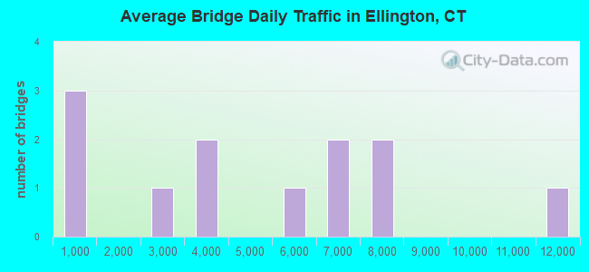
- 54,763Total average daily traffic
- 2,269Total average daily truck traffic
- 81,373Total future (year 2035) average daily traffic
- National Bridge Inventory (NBI) Registered Bridges for Ellington
- No street view available for this location
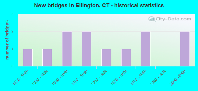
- New bridges - historical statistics
- 11920-1929
- 11930-1939
- 21940-1949
- 21950-1959
- 11960-1969
- 11970-1979
- 21980-1989
- 22000-2009
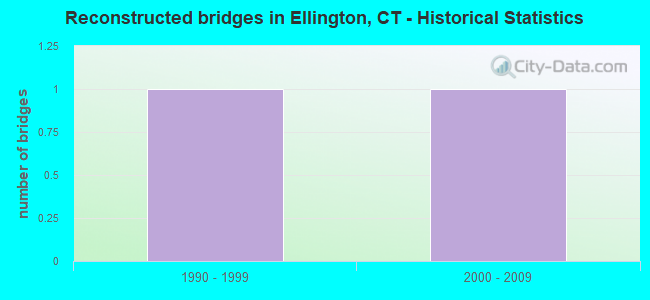
- Reconstructed bridges - Historical Statistics
- 11990-1999
- 12000-2009
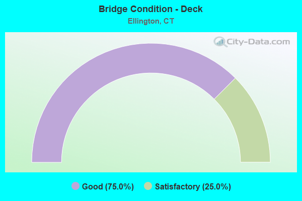
- Bridge Condition - Deck
- 75.0%Good
- 25.0%Satisfactory
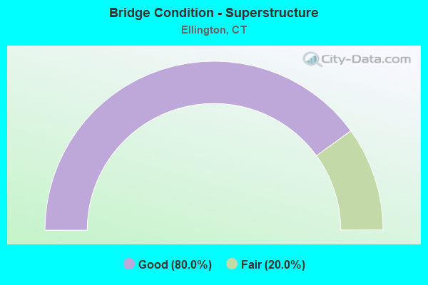
- Bridge Condition - Superstructure
- 80.0%Good
- 20.0%Fair
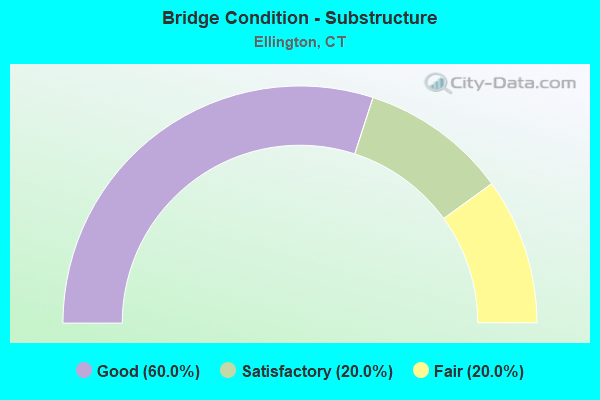
- Bridge Condition - Substructure
- 60.0%Good
- 20.0%Satisfactory
- 20.0%Fair
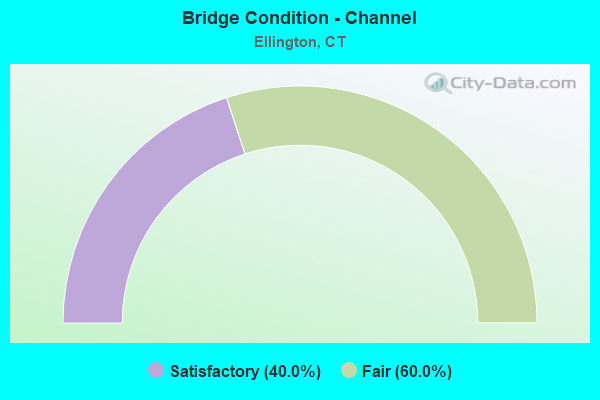
- Bridge Condition - Channel
- 40.0%Satisfactory
- 60.0%Fair
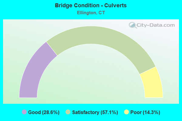
- Bridge Condition - Culverts
- 28.6%Good
- 57.1%Satisfactory
- 14.3%Poor
Find on map >> Show street view
Structure Number: 939, Location: 2.5 MILES NORTH OF I-84 (Lat: 41.929439, Lng: -72.307811), Route carried "on" structure: State highway 32, Year Built: 1954, Status: Open, Structure Length: 1.80m (5.91ft), Average Daily Traffic: 7,100 (year 2017), Truck Traffic: 5%, Average Future Daily Traffic: 10,550 (year 2037), Design Load: HS 20, Features Intersected: NEW ENGLAND CENTRAL RR
Minimum Vertical Clearance: 30+ m (98+ ft), Kilometerpoint: 75.784, Lanes on structure: 2, Base Highway Network: Yes, Owner: State Highway Agency, Approaching Roadway Width: 11.6m (38.1ft), Skew: 6 degrees, Material/Design: Steel, Design/Construction: Stringer/Multi-beam, Number Of Spans In Main Unit: 1, Length of Maximum Span: 14.6m (47.9ft), Curb or Sidewalk Widths: Left: 0.5m (1.6ft), Right: 0.5m (1.6ft), Curb-To-Curb Width: 11.6m (38.1ft), Out-to-Out Width: 13.3m (43.6ft)
Condition: Deck: Satisfactory, Superstructure: Good, Substructure: Satisfactory, Operating Rating: 42.8 metric tons, Method Used To Determine Operating Rating: Load and Resistance Factor Rating (LRFR) rating reported by rating factor(RF) method using HL-93 loadings, Inventory Rating: 33.0 metric tons, Method Used To Determine Inventory Rating: Load and Resistance Factor Rating (LRFR) rating reported by rating factor(RF) method using HL-93 loadings, Structural Evaluation: Equal to present minimum criteria, Deck Geometry: Somewhat better than minimum adequacy, Underclear: High priority of corrective action, Approach Roadway Alignment: Equal to present desirable criteria, Designated Inspection Frequency: Every 24 months, Inspection Date: June 2021, Deck Structure Type: Concrete Cast-file-Place, Wearing Surface/Protective System: Wearing Surface: Bituminous, Membrane: Preformed Fabric, Deck Protection: Epoxy Coated Reinforcing
Find on map >> Show street view
Structure Number: 1362, Location: 1.75 MILES W OF RT. 286 (Lat: 41.918725, Lng: -72.497272), Route carried "on" structure: State highway 140, Year Built: 1930, Year Reconstructed: 1995, Status: Open, Structure Length: 1.01m (3.31ft), Average Daily Traffic: 7,700 (year 2015), Truck Traffic: 4%, Average Future Daily Traffic: 11,441 (year 2035), Design Load: HS 20, Features Intersected: BROAD BROOK
Minimum Vertical Clearance: 30+ m (98+ ft), Kilometerpoint: 17.735, Lanes on structure: 2, Owner: State Highway Agency, Approaching Roadway Width: 9.1m (29.9ft), Skew: 3 degrees, Material/Design: Prestressed concrete, Design/Construction: Slab, Number Of Spans In Main Unit: 1, Length of Maximum Span: 9.4m (30.8ft), Curb or Sidewalk Widths: Left: 0.6m (2.0ft), Right: 0.6m (2.0ft), Curb-To-Curb Width: 9.8m (32.2ft), Out-to-Out Width: 10.9m (35.8ft)
Condition: Deck: Good, Superstructure: Good, Substructure: Good, Channel: Satisfactory, Operating Rating: 54.4 metric tons, Method Used To Determine Operating Rating: Load Factor (LF), Inventory Rating: 32.7 metric tons, Method Used To Determine Inventory Rating: Load Factor (LF), Structural Evaluation: Better than present minimum criteria, Deck Geometry: Meets minimum limits, Waterway Adequacy: Superior to present desirable criteria, Approach Roadway Alignment: Equal to present desirable criteria, Designated Inspection Frequency: Every 24 months, Inspection Date: August 2020, Deck Structure Type: Other, Wearing Surface/Protective System: Wearing Surface: Bituminous, Membrane: Built-up, Deck Protection: Epoxy Coated Reinforcing
Find on map >> Show street view
Structure Number: 2529, Location: 0.2 MILE NORTH OF RTE 140 (Lat: 41.914561, Lng: -72.453731), Route carried "on" structure: State highway 83, Year Built: 1927, Year Reconstructed: 2012, Status: Open, Structure Length: 0.91m (2.99ft), Average Daily Traffic: 6,200 (year 2020), Truck Traffic: 4%, Average Future Daily Traffic: 9,213 (year 2040), Design Load: HL 93, Features Intersected: KIMBALLS BROOK
Minimum Vertical Clearance: 30+ m (98+ ft), Kilometerpoint: 30.014, Lanes on structure: 2, Base Highway Network: Yes, Owner: State Highway Agency, Approaching Roadway Width: 11.0m (36.1ft), Material/Design: Concrete, Design/Construction: Slab, Number Of Spans In Main Unit: 1, Length of Maximum Span: 7.3m (24.0ft), Curb or Sidewalk Widths: Left: 0.6m (2.0ft), Right: 0.6m (2.0ft), Curb-To-Curb Width: 9.8m (32.2ft), Out-to-Out Width: 10.9m (35.8ft)
Condition: Deck: Good, Superstructure: Good, Substructure: Good, Channel: Fair, Operating Rating: 38.6 metric tons, Method Used To Determine Operating Rating: Load and Resistance Factor Rating (LRFR) rating reported by rating factor(RF) method using HL-93 loadings, Inventory Rating: 29.8 metric tons, Method Used To Determine Inventory Rating: Load and Resistance Factor Rating (LRFR) rating reported by rating factor(RF) method using HL-93 loadings, Structural Evaluation: Better than present minimum criteria, Deck Geometry: Meets minimum limits, Waterway Adequacy: Equal to present desirable criteria, Approach Roadway Alignment: Equal to present desirable criteria, Designated Inspection Frequency: Every 24 months, Inspection Date: Febuary 2022, Deck Structure Type: Concrete Cast-file-Place, Wearing Surface/Protective System: Wearing Surface: Bituminous, Membrane: Preformed Fabric, Deck Protection: Epoxy Coated Reinforcing
Find on map >> Show street view
Structure Number: 3543, Location: ROUTE 8 NB EXIT 2 (Lat: 41.178417, Lng: -73.194533), Route carried "on" structure: Ramp State highway 8, Year Built: 1968, Status: Open, Structure Length: 3.02m (9.91ft), Average Daily Traffic: 6,700 (year 2018), Truck Traffic: 5%, Average Future Daily Traffic: 9,956 (year 2038), Design Load: HS 20, Features Intersected: ROUTE 8 NB RAMP 127
Minimum Vertical Clearance: 30+ m (98+ ft), Kilometerpoint: 0.145, Lanes on structure: 1, Lanes under structure: 1, Owner: State Highway Agency, Approaching Roadway Width: 6.7m (22.0ft), Skew: 5 degrees, Material/Design: Steel, Design/Construction: Stringer/Multi-beam, Number Of Spans In Main Unit: 1, Length of Maximum Span: 27.4m (89.9ft), Curb-To-Curb Width: 6.7m (22.0ft), Out-to-Out Width: 8.4m (27.6ft)
Condition: Deck: Good, Superstructure: Good, Substructure: Good, Inventory Rating: 60.3 metric tons, Method Used To Determine Inventory Rating: Load Factor (LF), Structural Evaluation: Better than present minimum criteria, Deck Geometry: Equal to present minimum criteria, Underclear: Somewhat better than minimum adequacy, Approach Roadway Alignment: Equal to present minimum criteria, Designated Inspection Frequency: Every 24 months, Inspection Date: Febuary 2021, Deck Structure Type: Concrete Cast-file-Place, Wearing Surface/Protective System: Wearing Surface: Bituminous, Membrane: Preformed Fabric
Find on map >> Show street view
Structure Number: 3634, Location: .20 MI EAST OF ROUTE 69 (Lat: 41.704411, Lng: -72.943100), Route carried "on" structure: City street , Year Built: 1956, Status: Open, Structure Length: 0.64m (2.10ft), Average Daily Traffic: 11,033 (year 2020), Truck Traffic: 4%, Average Future Daily Traffic: 16,394 (year 2040), Design Load: HS 20, Features Intersected: POLKVILLE BROOK, Facility Carried by Structure: MAPLE AVENUE
Minimum Vertical Clearance: 30+ m (98+ ft), Kilometerpoint: 0.000, Lanes on structure: 2, Owner: City or Municipal Highway Agency, Approaching Roadway Width: 9.1m (29.9ft), Material/Design: Concrete continuous, Design/Construction: Culvert, Number Of Spans In Main Unit: 2, Length of Maximum Span: 3.0m (9.8ft), Curb or Sidewalk Widths: Left: 1.5m (4.9ft), Right: 0.0m, Out-to-Out Width: 15.2m (49.9ft)
Condition: Channel: Fair, Culverts: Satisfactory, Operating Rating: 55.1 metric tons, Method Used To Determine Operating Rating: Load and Resistance Factor Rating (LRFR) rating reported by rating factor(RF) method using HL-93 loadings, Inventory Rating: 42.4 metric tons, Method Used To Determine Inventory Rating: Load and Resistance Factor Rating (LRFR) rating reported by rating factor(RF) method using HL-93 loadings, Structural Evaluation: Equal to present minimum criteria, Waterway Adequacy: Better than present minimum criteria, Approach Roadway Alignment: Equal to present desirable criteria, Designated Inspection Frequency: Every 24 months, Inspection Date: October 2020, Deck Structure Type: Concrete Cast-file-Place, Wearing Surface/Protective System: Wearing Surface: Bituminous
Find on map >> Show street view
Structure Number: 4503, Location: 500 FT FR JCT ROUTE 286 (Lat: 41.878053, Lng: -72.482572), Route carried "on" structure: City street , Year Built: 2009, Status: Open, Structure Length: 1.71m (5.61ft), Average Daily Traffic: 3,538 (year 2021), Truck Traffic: 3%, Average Future Daily Traffic: 5,257 (year 2041), Design Load: HS 20, Features Intersected: HOCKANUM RIVER, Facility Carried by Structure: WINDERMERE AVENUE
Minimum Vertical Clearance: 30+ m (98+ ft), Kilometerpoint: 0.145, Lanes on structure: 2, Owner: Town or Township Highway Agency, Approaching Roadway Width: 9.8m (32.2ft), Material/Design: Concrete, Design/Construction: Culvert, Number Of Spans In Main Unit: 4, Length of Maximum Span: 3.7m (12.1ft), Curb or Sidewalk Widths: Left: 2.4m (7.9ft), Right: 0.0m, Curb-To-Curb Width: 10.1m (33.1ft), Out-to-Out Width: 13.3m (43.6ft)
Condition: Channel: Satisfactory, Culverts: Good, Operating Rating: 39.9 metric tons, Method Used To Determine Operating Rating: Load and Resistance Factor Rating (LRFR) rating reported by rating factor(RF) method using HL-93 loadings, Inventory Rating: 30.8 metric tons, Method Used To Determine Inventory Rating: Load and Resistance Factor Rating (LRFR) rating reported by rating factor(RF) method using HL-93 loadings, Structural Evaluation: Better than present minimum criteria, Deck Geometry: Meets minimum limits, Waterway Adequacy: Equal to present desirable criteria, Approach Roadway Alignment: Equal to present desirable criteria, Designated Inspection Frequency: Every 24 months, Inspection Date: Febuary 2021, Wearing Surface/Protective System: Wearing Surface: Bituminous
Find on map >> Show street view
Structure Number: 4504, Location: 0.6 MILE WEST OF ROUTE 83 (Lat: 41.875869, Lng: -72.474406), Route carried "on" structure: City street , Year Built: 2003, Status: Open, Structure Length: 0.76m (2.49ft), Average Daily Traffic: 3,141 (year 2019), Truck Traffic: 7%, Average Future Daily Traffic: 4,667 (year 2039), Features Intersected: HOCKANUM RIVER, Facility Carried by Structure: LOWER BUTCHER ROAD
Minimum Vertical Clearance: 30+ m (98+ ft), Kilometerpoint: 0.000, Lanes on structure: 2, Owner: Town or Township Highway Agency, Approaching Roadway Width: 13.4m (44.0ft), Material/Design: Concrete, Design/Construction: Culvert, Number Of Spans In Main Unit: 2, Length of Maximum Span: 3.7m (12.1ft), Curb or Sidewalk Widths: Left: 1.0m (3.3ft), Right: 2.0m (6.6ft), Curb-To-Curb Width: 9.8m (32.2ft), Out-to-Out Width: 13.6m (44.6ft)
Condition: Channel: Satisfactory, Culverts: Good, Operating Rating: 42.6 metric tons, Method Used To Determine Operating Rating: Field evaluation and documented engineering judgment, Inventory Rating: 32.7 metric tons, Method Used To Determine Inventory Rating: Field evaluation and documented engineering judgment, Structural Evaluation: Better than present minimum criteria, Deck Geometry: Meets minimum limits, Waterway Adequacy: Equal to present desirable criteria, Approach Roadway Alignment: Equal to present desirable criteria, Designated Inspection Frequency: Every 24 months, Inspection Date: Febuary 2021, Wearing Surface/Protective System: Wearing Surface: Bituminous, Membrane: Built-up
Find on map >> Show street view
Structure Number: 4505, Location: 0.2 MI FROM JCT RTE 140 (Lat: 41.920953, Lng: -72.505028), Route carried "on" structure: City street , Year Built: 1940, Status: Open, Structure Length: 1.25m (4.10ft), Average Daily Traffic: 884 (year 2021), Truck Traffic: 7%, Average Future Daily Traffic: 1,314 (year 2041), Design Load: H 15, Features Intersected: BROAD BROOK, Facility Carried by Structure: BROAD BROOK ROAD
Minimum Vertical Clearance: 30+ m (98+ ft), Kilometerpoint: 2.189, Lanes on structure: 2, Owner: Town or Township Highway Agency, Approaching Roadway Width: 6.1m (20.0ft), Skew: 3 degrees, Material/Design: Steel, Design/Construction: Arch - Deck, Number Of Spans In Main Unit: 2, Length of Maximum Span: 5.2m (17.1ft)
Condition: Superstructure: Fair, Substructure: Fair, Channel: Fair, Operating Rating: 97.2 metric tons, Method Used To Determine Operating Rating: Load and Resistance Factor Rating (LRFR) rating reported by rating factor(RF) method using HL-93 loadings, Inventory Rating: 97.2 metric tons, Method Used To Determine Inventory Rating: Load and Resistance Factor Rating (LRFR) rating reported by rating factor(RF) method using HL-93 loadings, Structural Evaluation: Somewhat better than minimum adequacy, Waterway Adequacy: Equal to present desirable criteria, Approach Roadway Alignment: Equal to present desirable criteria, Designated Inspection Frequency: Every 24 months, Inspection Date: Febuary 2021, Wearing Surface/Protective System: Wearing Surface: Bituminous
Find on map >> Show street view
Structure Number: 5375, Location: 0.5 MILE NORTH OF RTE 140 (Lat: 41.913447, Lng: -72.475883), Route carried "on" structure: City street , Year Built: 1986, Status: Open, Structure Length: 1.22m (4.00ft), Average Daily Traffic: 5,930 (year 2021), Truck Traffic: 2%, Average Future Daily Traffic: 8,811 (year 2041), Features Intersected: BROAD BROOK, Facility Carried by Structure: JOBS HILL ROAD
Minimum Vertical Clearance: 30+ m (98+ ft), Kilometerpoint: 0.000, Lanes on structure: 2, Owner: Town or Township Highway Agency, Approaching Roadway Width: 6.7m (22.0ft), Material/Design: Concrete, Design/Construction: Culvert, Number Of Spans In Main Unit: 3, Length of Maximum Span: 3.7m (12.1ft), Curb or Sidewalk Widths: Left: 1.7m (5.6ft), Right: 2.1m (6.9ft)
Condition: Channel: Fair, Culverts: Satisfactory, Operating Rating: 42.6 metric tons, Method Used To Determine Operating Rating: Field evaluation and documented engineering judgment, Inventory Rating: 32.7 metric tons, Method Used To Determine Inventory Rating: Field evaluation and documented engineering judgment, Structural Evaluation: Equal to present minimum criteria, Waterway Adequacy: Equal to present desirable criteria, Approach Roadway Alignment: Equal to present desirable criteria, Designated Inspection Frequency: Every 24 months, Inspection Date: Febuary 2021, Wearing Surface/Protective System: Wearing Surface: Bituminous
Find on map >> Show street view
Structure Number: 5609, Location: 0.1 MI FROM JCT CINDY RD. (Lat: 41.922881, Lng: -72.463658), Route carried "on" structure: City street , Year Built: 1970, Status: Open, Structure Length: 0.98m (3.22ft), Average Daily Traffic: 132 (year 2021), Truck Traffic: 7%, Average Future Daily Traffic: 196 (year 2041), Features Intersected: BROAD BROOK, Facility Carried by Structure: BRIDGE STREET
Minimum Vertical Clearance: 30+ m (98+ ft), Kilometerpoint: 0.113, Lanes on structure: 2, Owner: Town or Township Highway Agency, Approaching Roadway Width: 9.1m (29.9ft), Material/Design: Concrete continuous, Design/Construction: Culvert, Number Of Spans In Main Unit: 3, Length of Maximum Span: 3.0m (9.8ft), Curb or Sidewalk Widths: Left: 1.7m (5.6ft), Right: 0.6m (2.0ft), Curb-To-Curb Width: 9.1m (29.9ft), Out-to-Out Width: 12.2m (40.0ft)
Condition: Channel: Fair, Culverts: Satisfactory, Operating Rating: 42.6 metric tons, Method Used To Determine Operating Rating: Field evaluation and documented engineering judgment, Inventory Rating: 32.7 metric tons, Method Used To Determine Inventory Rating: Field evaluation and documented engineering judgment, Structural Evaluation: Equal to present minimum criteria, Deck Geometry: Equal to present minimum criteria, Waterway Adequacy: Equal to present desirable criteria, Approach Roadway Alignment: Equal to present desirable criteria, Designated Inspection Frequency: Every 24 months, Inspection Date: Febuary 2021, Wearing Surface/Protective System: Wearing Surface: Bituminous
Find on map >> Show street view
Structure Number: 5696, Location: 1 MI EAST OF RTE 30 (Lat: 41.931317, Lng: -72.367747), Route carried "on" structure: State highway 140, Year Built: 1988, Status: Open, Structure Length: 0.67m (2.20ft), Average Daily Traffic: 2,300 (year 2017), Truck Traffic: 3%, Average Future Daily Traffic: 3,418 (year 2037), Features Intersected: ABORN BROOK
Minimum Vertical Clearance: 30+ m (98+ ft), Kilometerpoint: 29.934, Lanes on structure: 2, Owner: State Highway Agency, Approaching Roadway Width: 8.2m (26.9ft), Skew: 5 degrees, Material/Design: Concrete, Design/Construction: Culvert, Number Of Spans In Main Unit: 2, Length of Maximum Span: 3.0m (9.8ft), Curb-To-Curb Width: 10.1m (33.1ft), Out-to-Out Width: 12.8m (42.0ft)
Condition: Channel: Satisfactory, Culverts: Satisfactory, Operating Rating: 42.6 metric tons, Method Used To Determine Operating Rating: Field evaluation and documented engineering judgment, Inventory Rating: 32.7 metric tons, Method Used To Determine Inventory Rating: Field evaluation and documented engineering judgment, Structural Evaluation: Equal to present minimum criteria, Deck Geometry: Meets minimum limits, Waterway Adequacy: Better than present minimum criteria, Approach Roadway Alignment: Equal to present desirable criteria, Designated Inspection Frequency: Every 24 months, Underwater Inspection Frequency: Every 24 months, Inspection Date: March 2020, Underwater Inspection Date: March 2020
Find on map >> Show street view
Structure Number: 6141, Location: 0.3 MILE WEST OF ROUTE 83 (Lat: 41.947806, Lng: -72.452672), Route carried "on" structure: City street , Year Built: 1940, Status: Open, Structure Length: 0.67m (2.20ft), Average Daily Traffic: 105 (year 2021), Average Future Daily Traffic: 156 (year 2041), Features Intersected: ABBEY BROOK, Facility Carried by Structure: STRAWBERRY ROAD
Minimum Vertical Clearance: 30+ m (98+ ft), Kilometerpoint: 0.000, Lanes on structure: 2, Owner: Town or Township Highway Agency, Approaching Roadway Width: 9.1m (29.9ft), Material/Design: Steel, Design/Construction: Culvert, Number Of Spans In Main Unit: 3, Length of Maximum Span: 1.8m (5.9ft)
Condition: Channel: Fair, Culverts: Poor, Operating Rating: 97.2 metric tons, Method Used To Determine Operating Rating: Load and Resistance Factor Rating (LRFR) rating reported by rating factor(RF) method using HL-93 loadings, Inventory Rating: 97.2 metric tons, Method Used To Determine Inventory Rating: Load and Resistance Factor Rating (LRFR) rating reported by rating factor(RF) method using HL-93 loadings, Structural Evaluation: Meets minimum limits, Waterway Adequacy: Equal to present desirable criteria, Approach Roadway Alignment: Equal to present desirable criteria, Designated Inspection Frequency: Every 24 months, Underwater Inspection Frequency: Every 24 months, Other Special Inspection Frequency: Every 12 months, Inspection Date: Febuary 2022, Underwater Inspection Date: Febuary 2022, Other Special Inspection Date: Febuary 2022, Total Project Cost: $2,600,000 ( Estimate for 2016), Wearing Surface/Protective System: Wearing Surface: Bituminous