Bridge Statistics for Elmwood Park, New Jersey (NJ)
Condition, Traffic, Stress, Structural Evaluation, Project Costs
- National Bridge Inventory (NBI) Statistics
- 53Number of bridges
- 528ft / 161mTotal length
- $6,865,000Total costs
- 2,707,273Total average daily traffic
- 139,225Total average daily truck traffic
- National Bridge Inventory (NBI) Registered Bridges for Elmwood Park
- No street view available for this location
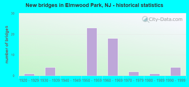
- New bridges - historical statistics
- 11920-1929
- 41930-1939
- 231950-1959
- 181960-1969
- 21970-1979
- 11980-1989
- 41990-1999
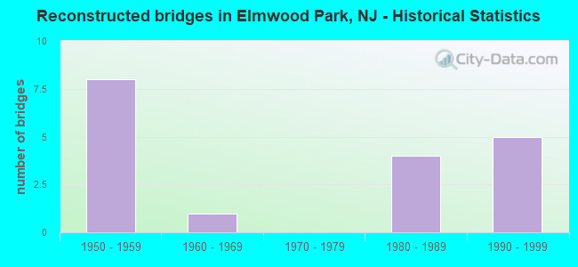
- Reconstructed bridges - Historical Statistics
- 81950-1959
- 11960-1969
- 01970-1979
- 41980-1989
- 51990-1999
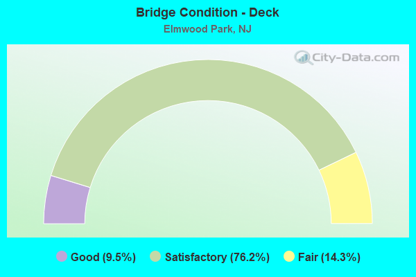
- Bridge Condition - Deck
- 9.5%Good
- 76.2%Satisfactory
- 14.3%Fair

- Bridge Condition - Superstructure
- 14.3%Good
- 57.1%Satisfactory
- 28.6%Fair
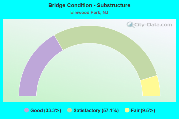
- Bridge Condition - Substructure
- 33.3%Good
- 57.1%Satisfactory
- 9.5%Fair
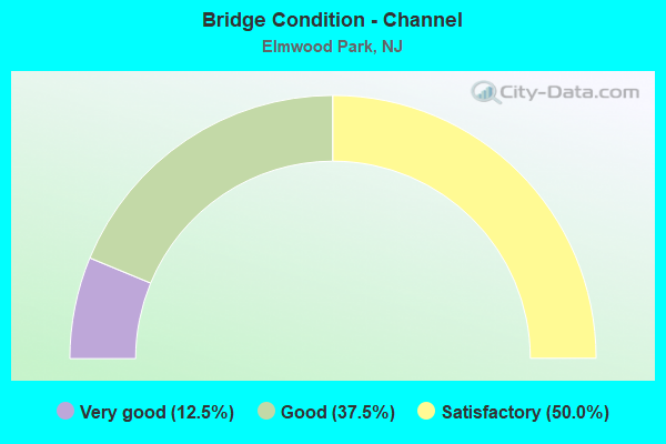
- Bridge Condition - Channel
- 12.5%Very good
- 37.5%Good
- 50.0%Satisfactory
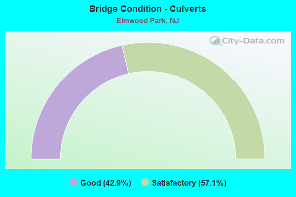
- Bridge Condition - Culverts
- 42.9%Good
- 57.1%Satisfactory
Find on map >> Show street view
Structure Number: 20011A, Location: .45 MI E. of River Rd. (Lat: 40.889850, Lng: -74.120569), Route carried "on" structure: City street , Year Built: 1975, Status: Open, Structure Length: 0.88m (2.89ft), Average Daily Traffic: 1,442 (year 2020), Truck Traffic: 1%, Average Future Daily Traffic: 1,731 (year 2040), Design Load: HS 20+Mod, Features Intersected: FLEISCHER BROOK, Facility Carried by Structure: KIPP AVENUE
Minimum Vertical Clearance: 30+ m (98+ ft), Kilometerpoint: 0.000, Lanes on structure: 2, Owner: County Highway Agency, Approaching Roadway Width: 9.1m (29.9ft), Skew: 1 degrees, Material/Design: Concrete, Design/Construction: Culvert, Number Of Spans In Main Unit: 2, Length of Maximum Span: 4.0m (13.1ft), Curb or Sidewalk Widths: Left: 1.9m (6.2ft), Right: 1.9m (6.2ft), Curb-To-Curb Width: 9.2m (30.2ft), Out-to-Out Width: 13.7m (44.9ft)
Condition: Channel: Satisfactory, Culverts: Good, Operating Rating: 43.5 metric tons, Method Used To Determine Operating Rating: Load Factor (LF), Inventory Rating: 26.3 metric tons, Method Used To Determine Inventory Rating: Load Factor (LF), Structural Evaluation: Equal to present minimum criteria, Deck Geometry: Somewhat better than minimum adequacy, Waterway Adequacy: Equal to present desirable criteria, Approach Roadway Alignment: Better than present minimum criteria, Designated Inspection Frequency: Every 24 months, Inspection Date: April 2020
Find on map >> Show street view
Structure Number: 20011B, Location: 0.45 MI E. of River Rd. (Lat: 40.890619, Lng: -74.120631), Route carried "on" structure: City street , Year Built: 1979, Status: Open, Structure Length: 0.88m (2.89ft), Average Daily Traffic: 1,823 (year 2020), Truck Traffic: 1%, Average Future Daily Traffic: 2,188 (year 2040), Design Load: HS 20+Mod, Features Intersected: FLEISCHER BROOK, Facility Carried by Structure: MARTHA AVENUE
Minimum Vertical Clearance: 30+ m (98+ ft), Kilometerpoint: 0.000, Lanes on structure: 2, Owner: County Highway Agency, Approaching Roadway Width: 9.1m (29.9ft), Skew: 1 degrees, Material/Design: Concrete, Design/Construction: Culvert, Number Of Spans In Main Unit: 2, Length of Maximum Span: 4.0m (13.1ft), Curb or Sidewalk Widths: Left: 2.7m (8.9ft), Right: 2.3m (7.5ft), Curb-To-Curb Width: 9.1m (29.9ft), Out-to-Out Width: 14.8m (48.6ft)
Condition: Channel: Satisfactory, Culverts: Good, Operating Rating: 50.8 metric tons, Method Used To Determine Operating Rating: Load Factor (LF), Inventory Rating: 29.9 metric tons, Method Used To Determine Inventory Rating: Load Factor (LF), Structural Evaluation: Better than present minimum criteria, Deck Geometry: Somewhat better than minimum adequacy, Waterway Adequacy: Equal to present desirable criteria, Approach Roadway Alignment: Equal to present desirable criteria, Designated Inspection Frequency: Every 24 months, Inspection Date: April 2020
Find on map >> Show street view
Structure Number: 20011C, Location: 0.1MI N. of Rt. 80 (Lat: 40.902461, Lng: -74.134081), Route carried "on" structure: County highway 56I, Year Built: 1923, Year Reconstructed: 1966, Status: Open, Structure Length: 11.19m (36.71ft), Average Daily Traffic: 4,520 (year 2020), Truck Traffic: 4%, Average Future Daily Traffic: 5,424 (year 2040), Features Intersected: PASSAIC RIVER, Facility Carried by Structure: MARKET ST. CR56 I
Minimum Vertical Clearance: 30+ m (98+ ft), Kilometerpoint: 0.000, Lanes on structure: 2, Owner: County Highway Agency, Approaching Roadway Width: 9.1m (29.9ft), Material/Design: Steel, Design/Construction: Girder and Floorbeam System, Number Of Spans In Main Unit: 6, Length of Maximum Span: 17.7m (58.1ft), Curb or Sidewalk Widths: Left: 1.8m (5.9ft), Right: 1.8m (5.9ft), Curb-To-Curb Width: 9.1m (29.9ft), Out-to-Out Width: 14.2m (46.6ft)
Condition: Deck: Satisfactory, Superstructure: Fair, Substructure: Fair, Channel: Very good, Operating Rating: 41.7 metric tons, Method Used To Determine Operating Rating: Load Factor (LF), Inventory Rating: 24.5 metric tons, Method Used To Determine Inventory Rating: Load Factor (LF), Structural Evaluation: Somewhat better than minimum adequacy, Deck Geometry: Meets minimum limits, Waterway Adequacy: Equal to present desirable criteria, Approach Roadway Alignment: Somewhat better than minimum adequacy, Designated Inspection Frequency: Every 24 months, Critical Feature Inspection Frequency: Every 24 months, Underwater Inspection Frequency: Every 48 months, Inspection Date: April 2020, Critical Feature Inspection Date: April 2020, Underwater Inspection Date: May 2020, Deck Structure Type: Concrete Cast-file-Place, Wearing Surface/Protective System: Wearing Surface: Bituminous
Find on map >> Show street view
Structure Number: 22015, Location: JCT of RT 46 & CR 507 (Lat: 40.893450, Lng: -74.126900), Route carried "on" structure: US 46, Year Built: 1939, Year Reconstructed: 1996, Status: Open, Structure Length: 2.07m (6.79ft), Average Daily Traffic: 73,021 (year 2020), Truck Traffic: 4%, Average Future Daily Traffic: 89,099 (year 2040), Design Load: HS 20, Features Intersected: RIVER DRIVE (CR 507)
Minimum Vertical Clearance: 30+ m (98+ ft), Kilometerpoint: 103.111, Lanes on structure: 6, Lanes under structure: 4, Base Highway Network: Yes, Owner: State Highway Agency, Approaching Roadway Width: 23.8m (78.1ft), Skew: 30 degrees, Material/Design: Steel, Design/Construction: Stringer/Multi-beam, Number Of Spans In Main Unit: 1, Length of Maximum Span: 19.5m (64.0ft), Curb or Sidewalk Widths: Left: 0.0m, Right: 2.7m (8.9ft), Curb-To-Curb Width: 24.1m (79.1ft), Out-to-Out Width: 28.5m (93.5ft)
Condition: Deck: Good, Superstructure: Satisfactory, Substructure: Satisfactory, Operating Rating: 73.5 metric tons, Method Used To Determine Operating Rating: Load Factor (LF), Inventory Rating: 43.5 metric tons, Method Used To Determine Inventory Rating: Load Factor (LF), Structural Evaluation: Equal to present minimum criteria, Deck Geometry: Somewhat better than minimum adequacy, Underclear: Meets minimum limits, Approach Roadway Alignment: Equal to present desirable criteria, Designated Inspection Frequency: Every 24 months, Inspection Date: March 2020, Deck Structure Type: Concrete Cast-file-Place, Wearing Surface/Protective System: Wearing Surface: Bituminous, Membrane: Preformed Fabric
Find on map >> Show street view
Structure Number: 220152, Location: 0.43 MILE EAST OF 507 JCT (Lat: 40.893050, Lng: -74.118550), Route carried "on" structure: US 46, Year Built: 1955, Status: Open, Structure Length: 0.76m (2.49ft), Average Daily Traffic: 69,500 (year 2021), Truck Traffic: 4%, Average Future Daily Traffic: 83,400 (year 2041), Features Intersected: BRANCH OF PASSAIC RIVER
Minimum Vertical Clearance: 30+ m (98+ ft), Kilometerpoint: 103.803, Lanes on structure: 5, Base Highway Network: Yes, Owner: State Highway Agency, Approaching Roadway Width: 26.5m (86.9ft), Skew: 30 degrees, Material/Design: Concrete, Design/Construction: Culvert, Number Of Spans In Main Unit: 1, Length of Maximum Span: 7.6m (24.9ft), Curb or Sidewalk Widths: Left: 6.3m (20.7ft), Right: 5.5m (18.0ft), Curb-To-Curb Width: 29.2m (95.8ft), Out-to-Out Width: 42.2m (138.5ft)
Condition: Channel: Satisfactory, Culverts: Satisfactory, Operating Rating: 54.4 metric tons, Method Used To Determine Operating Rating: Field evaluation and documented engineering judgment, Inventory Rating: 32.7 metric tons, Method Used To Determine Inventory Rating: Field evaluation and documented engineering judgment, Structural Evaluation: Equal to present minimum criteria, Deck Geometry: Superior to present desirable criteria, Waterway Adequacy: Superior to present desirable criteria, Approach Roadway Alignment: Equal to present desirable criteria, Designated Inspection Frequency: Every 24 months, Inspection Date: August 2021, Deck Structure Type: Concrete Cast-file-Place, Wearing Surface/Protective System: Wearing Surface: Bituminous
Find on map >> Show street view
Structure Number: 22515, Location: 0.23 Mi. East of Exit 60 (Lat: 40.901389, Lng: -74.130381), Route carried "on" structure: Interstate 80, Year Built: 1963, Status: Open, Structure Length: 1.19m (3.90ft), Average Daily Traffic: 125,000 (year 2021), Truck Traffic: 9%, Average Future Daily Traffic: 150,000 (year 2041), Design Load: HS 20, Features Intersected: ACCESS ROAD
Minimum Vertical Clearance: 30+ m (98+ ft), Kilometerpoint: 97.591, Lanes on structure: 10, Lanes under structure: 2, Base Highway Network: Yes, Owner: State Highway Agency, Approaching Roadway Width: 45.7m (149.9ft), Skew: 30 degrees, Material/Design: Steel, Design/Construction: Stringer/Multi-beam, Number Of Spans In Main Unit: 1, Length of Maximum Span: 11.0m (36.1ft), Curb-To-Curb Width: 45.7m (149.9ft), Out-to-Out Width: 48.1m (157.8ft)
Condition: Deck: Fair, Superstructure: Good, Substructure: Good, Operating Rating: 56.2 metric tons, Method Used To Determine Operating Rating: Load Factor (LF), Inventory Rating: 33.6 metric tons, Method Used To Determine Inventory Rating: Load Factor (LF), Structural Evaluation: Better than present minimum criteria, Deck Geometry: Superior to present desirable criteria, Underclear: High priority of replacement, Approach Roadway Alignment: Equal to present desirable criteria, Length Of Structure Improvement: 1.86m (6.10ft), Designated Inspection Frequency: Every 24 months, Inspection Date: September 2021, Bridge Improvement Cost: $3,887,000, Roadway Improvement Cost: $250,000, Total Project Cost: $5,939,000 ( Estimate for 2021), Deck Structure Type: Concrete Cast-file-Place, Wearing Surface/Protective System: Wearing Surface: Latex Concrete
Find on map >> Show street view
Structure Number: 225151, Location: 0.37 MI EAST OF PASSAIC R (Lat: 40.900961, Lng: -74.127311), Route carried "on" structure: Interstate 80, Year Built: 1963, Year Reconstructed: 1995, Status: Open, Structure Length: 6.68m (21.92ft), Average Daily Traffic: 155,658 (year 2021), Truck Traffic: 9%, Average Future Daily Traffic: 186,790 (year 2041), Design Load: HS 20, Features Intersected: RAMP A & RIVER DRIVE
Minimum Vertical Clearance: 30+ m (98+ ft), Kilometerpoint: 97.864, Lanes on structure: 9, Lanes under structure: 5, Base Highway Network: Yes, Owner: State Highway Agency, Approaching Roadway Width: 42.1m (138.1ft), Skew: 39 degrees, Material/Design: Prestressed concrete, Design/Construction: Stringer/Multi-beam, Number Of Spans In Main Unit: 4, Length of Maximum Span: 28.7m (94.2ft), Curb-To-Curb Width: 42.1m (138.1ft), Out-to-Out Width: 44.0m (144.4ft)
Condition: Deck: Fair, Superstructure: Satisfactory, Substructure: Satisfactory, Inventory Rating: 59.9 metric tons, Method Used To Determine Inventory Rating: Load Factor (LF), Structural Evaluation: Equal to present minimum criteria, Deck Geometry: Superior to present desirable criteria, Underclear: High priority of corrective action, Approach Roadway Alignment: Equal to present desirable criteria, Designated Inspection Frequency: Every 24 months, Inspection Date: April 2021, Bridge Improvement Cost: $600,000, Roadway Improvement Cost: $138,000, Total Project Cost: $896,000 ( Estimate for 2015), Deck Structure Type: Concrete Cast-file-Place, Wearing Surface/Protective System: Wearing Surface: Latex Concrete
Find on map >> Show street view
Structure Number: 225152, Location: 0.47 MI EAST OF PASSAIC R (Lat: 40.901100, Lng: -74.125511), Route carried "on" structure: Interstate 80, Year Built: 1962, Year Reconstructed: 1995, Status: Open, Structure Length: 5.58m (18.31ft), Average Daily Traffic: 155,658 (year 2021), Truck Traffic: 9%, Average Future Daily Traffic: 186,790 (year 2041), Design Load: HS 20+Mod, Features Intersected: MARKET STREET (CR 56 I)
Minimum Vertical Clearance: 30+ m (98+ ft), Kilometerpoint: 98.025, Lanes on structure: 9, Lanes under structure: 2, Base Highway Network: Yes, Owner: State Highway Agency, Approaching Roadway Width: 42.1m (138.1ft), Skew: 36 degrees, Material/Design: Steel, Design/Construction: Stringer/Multi-beam, Number Of Spans In Main Unit: 2, Length of Maximum Span: 27.4m (89.9ft), Curb-To-Curb Width: 42.2m (138.5ft), Out-to-Out Width: 43.9m (144.0ft)
Condition: Deck: Satisfactory, Superstructure: Satisfactory, Substructure: Satisfactory, Operating Rating: 49.9 metric tons, Method Used To Determine Operating Rating: Load Factor (LF), Inventory Rating: 29.9 metric tons, Method Used To Determine Inventory Rating: Load Factor (LF), Structural Evaluation: Equal to present minimum criteria, Deck Geometry: Superior to present desirable criteria, Underclear: Meets minimum limits, Approach Roadway Alignment: Equal to present desirable criteria, Designated Inspection Frequency: Every 24 months, Critical Feature Inspection Frequency: Every 24 months, Inspection Date: April 2021, Critical Feature Inspection Date: April 2021, Deck Structure Type: Concrete Cast-file-Place, Wearing Surface/Protective System: Wearing Surface: Monolithic Concrete, Deck Protection: Epoxy Coated Reinforcing
Find on map >> Show street view
Structure Number: 225153, Location: 0.4 MI EAST OF PASC RIV (Lat: 40.901069, Lng: -74.125131), Route carried "on" structure: Ramp Interstate 80, Year Built: 1962, Year Reconstructed: 1994, Status: Open, Structure Length: 3.63m (11.91ft), Average Daily Traffic: 4,987 (year 2020), Truck Traffic: 9%, Average Future Daily Traffic: 7,430 (year 2040), Design Load: HS 20, Features Intersected: MARKET STREET, Facility Carried by Structure: RAMP B
Minimum Vertical Clearance: 30+ m (98+ ft), Kilometerpoint: 98.025, Lanes on structure: 1, Lanes under structure: 2, Owner: State Highway Agency, Approaching Roadway Width: 6.7m (22.0ft), Skew: 5 degrees, Material/Design: Steel, Design/Construction: Stringer/Multi-beam, Number Of Spans In Main Unit: 2, Length of Maximum Span: 17.4m (57.1ft), Curb-To-Curb Width: 6.7m (22.0ft), Out-to-Out Width: 7.8m (25.6ft)
Condition: Deck: Satisfactory, Superstructure: Good, Substructure: Satisfactory, Operating Rating: 84.4 metric tons, Method Used To Determine Operating Rating: Load Factor (LF), Inventory Rating: 50.8 metric tons, Method Used To Determine Inventory Rating: Load Factor (LF), Structural Evaluation: Equal to present minimum criteria, Deck Geometry: Equal to present minimum criteria, Underclear: Meets minimum limits, Approach Roadway Alignment: Better than present minimum criteria, Designated Inspection Frequency: Every 24 months, Inspection Date: October 2020, Deck Structure Type: Concrete Cast-file-Place, Wearing Surface/Protective System: Wearing Surface: Bituminous
Find on map >> Show street view
Structure Number: 225154, Location: 0.6 MI EAST OF PASSAIC R (Lat: 40.902169, Lng: -74.122289), Route carried "on" structure: Interstate 80, Year Built: 1962, Year Reconstructed: 1993, Status: Open, Structure Length: 1.95m (6.40ft), Average Daily Traffic: 138,000 (year 2020), Truck Traffic: 9%, Average Future Daily Traffic: 165,600 (year 2040), Design Load: HS 20+Mod, Features Intersected: SOUTH CENTER ST.
Minimum Vertical Clearance: 30+ m (98+ ft), Kilometerpoint: 98.267, Lanes on structure: 9, Lanes under structure: 2, Base Highway Network: Yes, Owner: State Highway Agency, Approaching Roadway Width: 48.2m (158.1ft), Skew: 33 degrees, Material/Design: Prestressed concrete, Design/Construction: Stringer/Multi-beam, Number Of Spans In Main Unit: 1, Length of Maximum Span: 17.7m (58.1ft), Curb-To-Curb Width: 48.2m (158.1ft), Out-to-Out Width: 50.2m (164.7ft)
Condition: Deck: Satisfactory, Superstructure: Satisfactory, Substructure: Satisfactory, Operating Rating: 49.9 metric tons, Method Used To Determine Operating Rating: Load Factor (LF), Inventory Rating: 29.0 metric tons, Method Used To Determine Inventory Rating: Load Factor (LF), Structural Evaluation: Equal to present minimum criteria, Deck Geometry: Superior to present desirable criteria, Underclear: Equal to present minimum criteria, Approach Roadway Alignment: Equal to present desirable criteria, Designated Inspection Frequency: Every 24 months, Inspection Date: July 2020, Deck Structure Type: Concrete Cast-file-Place, Wearing Surface/Protective System: Wearing Surface: Latex Concrete
Find on map >> Show street view
Structure Number: 225155, Location: 0.7 MI EAST OF PASSAIC R (Lat: 40.902900, Lng: -74.120331), Route carried "on" structure: Interstate 80, Year Built: 1963, Year Reconstructed: 1993, Status: Open, Structure Length: 7.41m (24.31ft), Average Daily Traffic: 138,000 (year 2020), Truck Traffic: 9%, Average Future Daily Traffic: 165,600 (year 2040), Design Load: HS 25 or greater, Features Intersected: NYS&W RR
Minimum Vertical Clearance: 30+ m (98+ ft), Kilometerpoint: 98.476, Lanes on structure: 9, Base Highway Network: Yes, Owner: State Highway Agency, Approaching Roadway Width: 46.0m (150.9ft), Skew: 36 degrees, Material/Design: Prestressed concrete, Design/Construction: Stringer/Multi-beam, Number Of Spans In Main Unit: 3, Length of Maximum Span: 27.4m (89.9ft), Curb-To-Curb Width: 45.3m (148.6ft), Out-to-Out Width: 47.2m (154.9ft)
Condition: Deck: Satisfactory, Superstructure: Satisfactory, Substructure: Satisfactory, Operating Rating: 59.9 metric tons, Method Used To Determine Operating Rating: Load Factor (LF), Inventory Rating: 29.0 metric tons, Method Used To Determine Inventory Rating: Load Factor (LF), Structural Evaluation: Equal to present minimum criteria, Deck Geometry: Superior to present desirable criteria, Underclear: Equal to present minimum criteria, Approach Roadway Alignment: Equal to present desirable criteria, Designated Inspection Frequency: Every 24 months, Inspection Date: July 2020, Deck Structure Type: Concrete Cast-file-Place, Wearing Surface/Protective System: Wearing Surface: Bituminous
Find on map >> Show street view
Structure Number: 225156, Location: 0.5 MI WEST OF GS PARKWY (Lat: 40.903819, Lng: -74.118069), Route carried "on" structure: Interstate 80, Year Built: 1962, Year Reconstructed: 1993, Status: Open, Structure Length: 2.10m (6.89ft), Average Daily Traffic: 132,720 (year 2020), Truck Traffic: 9%, Average Future Daily Traffic: 161,918 (year 2040), Design Load: HS 20+Mod, Features Intersected: BOULEVARD
Minimum Vertical Clearance: 30+ m (98+ ft), Kilometerpoint: 98.669, Lanes on structure: 9, Lanes under structure: 3, Base Highway Network: Yes, Owner: State Highway Agency, Approaching Roadway Width: 44.2m (145.0ft), Skew: 31 degrees, Material/Design: Prestressed concrete, Design/Construction: Stringer/Multi-beam, Number Of Spans In Main Unit: 1, Length of Maximum Span: 19.8m (65.0ft), Curb-To-Curb Width: 45.2m (148.3ft), Out-to-Out Width: 47.0m (154.2ft)
Condition: Deck: Satisfactory, Superstructure: Satisfactory, Substructure: Satisfactory, Operating Rating: 89.8 metric tons, Method Used To Determine Operating Rating: Load Factor (LF), Inventory Rating: 49.9 metric tons, Method Used To Determine Inventory Rating: Load Factor (LF), Structural Evaluation: Equal to present minimum criteria, Deck Geometry: Superior to present desirable criteria, Underclear: Meets minimum limits, Approach Roadway Alignment: Equal to present desirable criteria, Designated Inspection Frequency: Every 24 months, Inspection Date: May 2020, Deck Structure Type: Concrete Cast-file-Place, Wearing Surface/Protective System: Wearing Surface: Latex Concrete
Find on map >> Show street view
Structure Number: 225158, Location: 0.20 MI WEST OF GSP (Lat: 40.904031, Lng: -74.112300), Route carried "on" structure: Interstate 80, Year Built: 1962, Status: Open, Structure Length: 0.64m (2.10ft), Average Daily Traffic: 139,400 (year 2021), Truck Traffic: 9%, Average Future Daily Traffic: 167,200 (year 2041), Features Intersected: FLEISCHER BROOK
Minimum Vertical Clearance: 30+ m (98+ ft), Kilometerpoint: 99.152, Lanes on structure: 11, Base Highway Network: Yes, Owner: State Highway Agency, Approaching Roadway Width: 89.3m (293.0ft), Skew: 31 degrees, Material/Design: Concrete, Design/Construction: Culvert, Number Of Spans In Main Unit: 1, Length of Maximum Span: 6.4m (21.0ft), Curb or Sidewalk Widths: Left: 3.0m (9.8ft), Right: 0.0m
Condition: Channel: Good, Culverts: Good, Operating Rating: 70.8 metric tons, Method Used To Determine Operating Rating: Load Factor (LF), Inventory Rating: 42.6 metric tons, Method Used To Determine Inventory Rating: Load Factor (LF), Structural Evaluation: Better than present minimum criteria, Waterway Adequacy: Equal to present desirable criteria, Approach Roadway Alignment: Equal to present desirable criteria, Designated Inspection Frequency: Every 24 months, Inspection Date: September 2021
Find on map >> Show street view
Structure Number: 225159, Location: 1.41 MI E OF NJ 20 (Lat: 40.903839, Lng: -74.108919), Route carried "on" structure: Interstate 80, Year Built: 1965, Year Reconstructed: 1996, Status: Open, Structure Length: 31.58m (103.61ft), Average Daily Traffic: 139,500 (year 2021), Truck Traffic: 9%, Average Future Daily Traffic: 167,400 (year 2041), Design Load: HS 20+Mod, Features Intersected: GSP,MIDLAND & NJ TRANSIT
Minimum Vertical Clearance: 30+ m (98+ ft), Kilometerpoint: 99.441, Lanes on structure: 9, Lanes under structure: 11, Base Highway Network: Yes, Owner: State Highway Agency, Approaching Roadway Width: 41.5m (136.2ft), Skew: 35 degrees, Material/Design: Steel, Design/Construction: Stringer/Multi-beam, Number Of Spans In Main Unit: 4, Number Of Approach Spans: 11, Length of Maximum Span: 32.0m (105.0ft), Curb-To-Curb Width: 42.1m (138.1ft), Out-to-Out Width: 44.0m (144.4ft)
Condition: Deck: Satisfactory, Superstructure: Fair, Substructure: Fair, Operating Rating: 57.2 metric tons, Method Used To Determine Operating Rating: Load Factor (LF), Inventory Rating: 35.4 metric tons, Method Used To Determine Inventory Rating: Load Factor (LF), Structural Evaluation: Somewhat better than minimum adequacy, Deck Geometry: Superior to present desirable criteria, Underclear: High priority of corrective action, Approach Roadway Alignment: Equal to present desirable criteria, Length Of Structure Improvement: 30.48m (100.00ft), Designated Inspection Frequency: Every 24 months, Inspection Date: July 2021, Bridge Improvement Cost: $1,000, Roadway Improvement Cost: $24,000, Total Project Cost: $30,000 ( Estimate for 2021), Deck Structure Type: Concrete Cast-file-Place, Wearing Surface/Protective System: Wearing Surface: Latex Concrete
Find on map >> Show street view
Structure Number: 2C1111, Location: 250 ft east of Boulevard (Lat: 40.899339, Lng: -74.114819), Route carried "on" structure: County highway 56I, Year Built: 1993, Status: Open, Structure Length: 0.85m (2.79ft), Average Daily Traffic: 4,520 (year 2020), Truck Traffic: 4%, Average Future Daily Traffic: 5,424 (year 2040), Design Load: HS 25 or greater, Features Intersected: Trib. of Fleischer Brook, Facility Carried by Structure: Martket Street
Minimum Vertical Clearance: 30+ m (98+ ft), Kilometerpoint: 1.625, Lanes on structure: 2, Owner: County Highway Agency, Approaching Roadway Width: 14.6m (47.9ft), Material/Design: Concrete, Design/Construction: Culvert, Number Of Spans In Main Unit: 2, Length of Maximum Span: 3.7m (12.1ft), Curb or Sidewalk Widths: Left: 2.4m (7.9ft), Right: 2.2m (7.2ft), Curb-To-Curb Width: 14.6m (47.9ft), Out-to-Out Width: 20.1m (65.9ft)
Condition: Channel: Satisfactory, Culverts: Satisfactory, Operating Rating: 89.8 metric tons, Method Used To Determine Operating Rating: Load Factor (LF), Inventory Rating: 69.9 metric tons, Method Used To Determine Inventory Rating: Load Factor (LF), Structural Evaluation: Equal to present minimum criteria, Deck Geometry: Superior to present desirable criteria, Waterway Adequacy: Equal to present desirable criteria, Approach Roadway Alignment: Better than present minimum criteria, Designated Inspection Frequency: Every 24 months, Inspection Date: April 2020
Find on map >> Show street view
Structure Number: 2M111, Location: 0.06 Mi. S. of Market (Lat: 40.898639, Lng: -74.115261), Route carried "on" structure: City street , Year Built: 1988, Status: Open, Structure Length: 0.88m (2.89ft), Average Daily Traffic: 14,347 (year 2020), Truck Traffic: 3%, Average Future Daily Traffic: 17,506 (year 2040), Design Load: HS 20+Mod, Features Intersected: FLEISCHER BROOK, Facility Carried by Structure: BOULEVARD
Minimum Vertical Clearance: 30+ m (98+ ft), Kilometerpoint: 1.883, Lanes on structure: 2, Owner: City or Municipal Highway Agency, Approaching Roadway Width: 12.8m (42.0ft), Skew: 2 degrees, Material/Design: Concrete, Design/Construction: Culvert, Number Of Spans In Main Unit: 2, Length of Maximum Span: 4.0m (13.1ft), Curb or Sidewalk Widths: Left: 3.0m (9.8ft), Right: 3.0m (9.8ft), Curb-To-Curb Width: 14.0m (45.9ft), Out-to-Out Width: 20.7m (67.9ft)
Condition: Channel: Good, Culverts: Satisfactory, Operating Rating: 54.4 metric tons, Method Used To Determine Operating Rating: Field evaluation and documented engineering judgment, Inventory Rating: 32.7 metric tons, Method Used To Determine Inventory Rating: Field evaluation and documented engineering judgment, Structural Evaluation: Equal to present minimum criteria, Deck Geometry: Superior to present desirable criteria, Waterway Adequacy: Equal to present desirable criteria, Approach Roadway Alignment: Equal to present desirable criteria, Designated Inspection Frequency: Every 24 months, Inspection Date: April 2020
Find on map >> Show street view
Structure Number: 361586T, Location: 0.5 MI SW OF GSP&RT46 JCT (Lat: 40.890564, Lng: -74.124089), Route carried "on" structure: City street , Year Built: 1954, Status: Open, Structure Length: 4.85m (15.91ft), Average Daily Traffic: 7,128 (year 2020), Truck Traffic: 1%, Average Future Daily Traffic: 8,698 (year 2040), Design Load: H 20, Features Intersected: GARDEN ST PARKWAY, Facility Carried by Structure: MILES STREET
Minimum Vertical Clearance: 30+ m (98+ ft), Kilometerpoint: 0.000, Lanes on structure: 2, Lanes under structure: 6, Owner: State Toll Authority, Approaching Roadway Width: 9.1m (29.9ft), Material/Design: Steel, Design/Construction: Stringer/Multi-beam, Number Of Spans In Main Unit: 4, Length of Maximum Span: 14.9m (48.9ft), Curb or Sidewalk Widths: Left: 1.8m (5.9ft), Right: 1.8m (5.9ft), Curb-To-Curb Width: 9.1m (29.9ft), Out-to-Out Width: 13.5m (44.3ft)
Condition: Deck: Satisfactory, Superstructure: Satisfactory, Substructure: Good, Operating Rating: 37.9 metric tons, Method Used To Determine Operating Rating: Load and Resistance Factor Rating (LRFR) rating reported by rating factor(RF) method using HL-93 loadings, Inventory Rating: 29.2 metric tons, Method Used To Determine Inventory Rating: Load and Resistance Factor Rating (LRFR) rating reported by rating factor(RF) method using HL-93 loadings, Structural Evaluation: Equal to present minimum criteria, Deck Geometry: High priority of corrective action, Underclear: High priority of corrective action, Approach Roadway Alignment: Better than present minimum criteria, Designated Inspection Frequency: Every 24 months, Inspection Date: January 2020, Deck Structure Type: Concrete Cast-file-Place, Wearing Surface/Protective System: Wearing Surface: Monolithic Concrete
Find on map >> Show street view
Structure Number: 361588S, Location: AT GSP & RT 46 JUNCTION (Lat: 40.893231, Lng: -74.120289), Route carried "on" structure: Other road GSP, Year Built: 1954, Year Reconstructed: 1962, Status: Open, Structure Length: 6.98m (22.90ft), Average Daily Traffic: 67,700 (year 2020), Truck Traffic: 1%, Average Future Daily Traffic: 81,250 (year 2040), Design Load: H 20, Features Intersected: ROUTE US 46, Facility Carried by Structure: PARKWAY S
Minimum Vertical Clearance: 30+ m (98+ ft), Kilometerpoint: 255.564, Lanes on structure: 4, Lanes under structure: 6, Base Highway Network: Yes, Toll: On toll road, Owner: State Toll Authority, Approaching Roadway Width: 17.8m (58.4ft), Skew: 3 degrees, Material/Design: Steel, Design/Construction: Stringer/Multi-beam, Number Of Spans In Main Unit: 4, Length of Maximum Span: 22.9m (75.1ft), Curb-To-Curb Width: 17.8m (58.4ft), Out-to-Out Width: 18.9m (62.0ft)
Condition: Deck: Satisfactory, Superstructure: Satisfactory, Substructure: Satisfactory, Operating Rating: 30.8 metric tons, Method Used To Determine Operating Rating: Load and Resistance Factor Rating (LRFR) rating reported by rating factor(RF) method using HL-93 loadings, Inventory Rating: 23.7 metric tons, Method Used To Determine Inventory Rating: Load and Resistance Factor Rating (LRFR) rating reported by rating factor(RF) method using HL-93 loadings, Structural Evaluation: Somewhat better than minimum adequacy, Deck Geometry: Meets minimum limits, Underclear: Somewhat better than minimum adequacy, Approach Roadway Alignment: Better than present minimum criteria, Designated Inspection Frequency: Every 24 months, Inspection Date: January 2020, Deck Structure Type: Concrete Cast-file-Place, Wearing Surface/Protective System: Wearing Surface: Bituminous
Find on map >> Show street view
Structure Number: 361589N, Location: AT GSP & US46 JUNCTION (Lat: 40.893231, Lng: -74.119989), Route carried "on" structure: Other road GSP, Year Built: 1954, Year Reconstructed: 1962, Status: Open, Structure Length: 6.98m (22.90ft), Average Daily Traffic: 65,800 (year 2020), Truck Traffic: 1%, Average Future Daily Traffic: 80,276 (year 2040), Design Load: H 20, Features Intersected: ROUTE US 46, Facility Carried by Structure: GARDEN ST PRKWY NB
Minimum Vertical Clearance: 30+ m (98+ ft), Kilometerpoint: 255.676, Lanes on structure: 4, Lanes under structure: 6, Base Highway Network: Yes, Toll: On toll road, Owner: State Toll Authority, Approaching Roadway Width: 17.7m (58.1ft), Skew: 3 degrees, Material/Design: Steel, Design/Construction: Stringer/Multi-beam, Number Of Spans In Main Unit: 4, Length of Maximum Span: 22.9m (75.1ft), Curb-To-Curb Width: 17.8m (58.4ft), Out-to-Out Width: 18.9m (62.0ft)
Condition: Deck: Satisfactory, Superstructure: Satisfactory, Substructure: Good, Operating Rating: 38.2 metric tons, Method Used To Determine Operating Rating: Load and Resistance Factor Rating (LRFR) rating reported by rating factor(RF) method using HL-93 loadings, Inventory Rating: 29.5 metric tons, Method Used To Determine Inventory Rating: Load and Resistance Factor Rating (LRFR) rating reported by rating factor(RF) method using HL-93 loadings, Structural Evaluation: Equal to present minimum criteria, Deck Geometry: Meets minimum limits, Underclear: Equal to present minimum criteria, Approach Roadway Alignment: Better than present minimum criteria, Designated Inspection Frequency: Every 24 months, Inspection Date: January 2020, Deck Structure Type: Concrete Cast-file-Place, Wearing Surface/Protective System: Wearing Surface: Bituminous
Find on map >> Show street view
Structure Number: 361590T, Location: AT GSP & RT46 JUNCTION (Lat: 40.895439, Lng: -74.117972), Route carried "on" structure: Other road GSP, Year Built: 1954, Status: Open, Structure Length: 0.91m (2.99ft), Average Daily Traffic: 74,307 (year 2020), Truck Traffic: 1%, Average Future Daily Traffic: 90,668 (year 2040), Design Load: H 20, Features Intersected: FLEISHER BROOK, Facility Carried by Structure: GARDEN ST PARKWAY
Minimum Vertical Clearance: 30+ m (98+ ft), Kilometerpoint: 255.725, Lanes on structure: 7, Base Highway Network: Yes, Toll: On toll road, Owner: State Toll Authority, Approaching Roadway Width: 32.0m (105.0ft), Skew: 35 degrees, Material/Design: Concrete, Design/Construction: Culvert, Number Of Spans In Main Unit: 1, Length of Maximum Span: 5.8m (19.0ft)
Condition: Channel: Good, Culverts: Satisfactory, Operating Rating: 96.9 metric tons, Method Used To Determine Operating Rating: Load and Resistance Factor Rating (LRFR) rating reported by rating factor(RF) method using HL-93 loadings, Inventory Rating: 96.9 metric tons, Method Used To Determine Inventory Rating: Load and Resistance Factor Rating (LRFR) rating reported by rating factor(RF) method using HL-93 loadings, Structural Evaluation: Equal to present minimum criteria, Waterway Adequacy: Equal to present desirable criteria, Approach Roadway Alignment: Equal to present desirable criteria, Designated Inspection Frequency: Every 24 months, Inspection Date: Febuary 2020
Find on map >> Show street view
Structure Number: 361592S, Location: 0.5 MI NE OF GSP&RT46 JCT (Lat: 40.898056, Lng: -74.115194), Route carried "on" structure: Other road GSP, Year Built: 1954, Year Reconstructed: 1962, Status: Open, Structure Length: 4.27m (14.01ft), Average Daily Traffic: 60,770 (year 2020), Truck Traffic: 1%, Average Future Daily Traffic: 74,155 (year 2040), Design Load: H 20, Features Intersected: MOLA BOULEVARD, Facility Carried by Structure: GARDEN ST PKWY SB
Minimum Vertical Clearance: 30+ m (98+ ft), Kilometerpoint: 256.208, Lanes on structure: 3, Lanes under structure: 2, Base Highway Network: Yes, Toll: On toll road, Owner: State Toll Authority, Approaching Roadway Width: 15.5m (50.9ft), Skew: 3 degrees, Material/Design: Steel, Design/Construction: Stringer/Multi-beam, Number Of Spans In Main Unit: 3, Length of Maximum Span: 22.6m (74.1ft), Curb-To-Curb Width: 15.5m (50.9ft), Out-to-Out Width: 16.6m (54.5ft)
Condition: Deck: Satisfactory, Superstructure: Fair, Substructure: Satisfactory, Operating Rating: 28.2 metric tons, Method Used To Determine Operating Rating: Load and Resistance Factor Rating (LRFR) rating reported by rating factor(RF) method using HL-93 loadings, Inventory Rating: 21.7 metric tons, Method Used To Determine Inventory Rating: Load and Resistance Factor Rating (LRFR) rating reported by rating factor(RF) method using HL-93 loadings, Structural Evaluation: Somewhat better than minimum adequacy, Deck Geometry: Somewhat better than minimum adequacy, Underclear: Better than present minimum criteria, Approach Roadway Alignment: Better than present minimum criteria, Designated Inspection Frequency: Every 24 months, Inspection Date: January 2020, Deck Structure Type: Concrete Cast-file-Place, Wearing Surface/Protective System: Wearing Surface: Bituminous
Find on map >> Show street view
Structure Number: 361593N, Location: 0.5 MI NE OF GSP&RT46 JCT (Lat: 40.897994, Lng: -74.115453), Route carried "on" structure: Other road GSP, Year Built: 1954, Year Reconstructed: 1962, Status: Open, Structure Length: 4.27m (14.01ft), Average Daily Traffic: 59,870 (year 2020), Truck Traffic: 1%, Average Future Daily Traffic: 73,050 (year 2040), Design Load: H 20, Features Intersected: MOLA BOULEVARD, Facility Carried by Structure: GARDEN ST PKWY NB
Minimum Vertical Clearance: 30+ m (98+ ft), Kilometerpoint: 256.369, Lanes on structure: 3, Lanes under structure: 2, Base Highway Network: Yes, Toll: On toll road, Owner: State Toll Authority, Approaching Roadway Width: 15.8m (51.8ft), Skew: 3 degrees, Material/Design: Steel, Design/Construction: Stringer/Multi-beam, Number Of Spans In Main Unit: 3, Length of Maximum Span: 22.6m (74.1ft), Curb-To-Curb Width: 15.9m (52.2ft), Out-to-Out Width: 17.0m (55.8ft)
Condition: Deck: Satisfactory, Superstructure: Fair, Substructure: Satisfactory, Operating Rating: 31.1 metric tons, Method Used To Determine Operating Rating: Load and Resistance Factor Rating (LRFR) rating reported by rating factor(RF) method using HL-93 loadings, Inventory Rating: 24.0 metric tons, Method Used To Determine Inventory Rating: Load and Resistance Factor Rating (LRFR) rating reported by rating factor(RF) method using HL-93 loadings, Structural Evaluation: Somewhat better than minimum adequacy, Deck Geometry: Somewhat better than minimum adequacy, Underclear: Somewhat better than minimum adequacy, Approach Roadway Alignment: Better than present minimum criteria, Designated Inspection Frequency: Every 24 months, Inspection Date: January 2020, Deck Structure Type: Concrete Cast-file-Place, Wearing Surface/Protective System: Wearing Surface: Bituminous
Find on map >> Show street view
Structure Number: 361593S, Location: 0.5 MI NE OF GSP&RT46 JCT (Lat: 40.899572, Lng: -74.114164), Route carried "on" structure: Other road GSP, Year Built: 1954, Year Reconstructed: 1962, Status: Open, Structure Length: 4.18m (13.71ft), Average Daily Traffic: 61,710 (year 2020), Truck Traffic: 1%, Average Future Daily Traffic: 75,300 (year 2040), Design Load: HS 20, Features Intersected: MARKET STREET (CR 56 I), Facility Carried by Structure: GARDEN ST PKWY SB
Minimum Vertical Clearance: 30+ m (98+ ft), Kilometerpoint: 256.369, Lanes on structure: 3, Lanes under structure: 2, Base Highway Network: Yes, Toll: On toll road, Owner: State Toll Authority, Approaching Roadway Width: 15.5m (50.9ft), Skew: 2 degrees, Material/Design: Steel, Design/Construction: Stringer/Multi-beam, Number Of Spans In Main Unit: 3, Length of Maximum Span: 21.3m (69.9ft), Curb-To-Curb Width: 15.7m (51.5ft), Out-to-Out Width: 16.8m (55.1ft)
Condition: Deck: Satisfactory, Superstructure: Satisfactory, Substructure: Good, Operating Rating: 35.3 metric tons, Method Used To Determine Operating Rating: Load and Resistance Factor Rating (LRFR) rating reported by rating factor(RF) method using HL-93 loadings, Inventory Rating: 27.2 metric tons, Method Used To Determine Inventory Rating: Load and Resistance Factor Rating (LRFR) rating reported by rating factor(RF) method using HL-93 loadings, Structural Evaluation: Equal to present minimum criteria, Deck Geometry: Somewhat better than minimum adequacy, Underclear: Equal to present minimum criteria, Approach Roadway Alignment: Equal to present desirable criteria, Designated Inspection Frequency: Every 24 months, Inspection Date: January 2020, Deck Structure Type: Concrete Cast-file-Place, Wearing Surface/Protective System: Wearing Surface: Bituminous
Find on map >> Show street view
Structure Number: 361594N, Location: 0.5 MI NE OF GSP&RT46 JCT (Lat: 40.899128, Lng: -74.114161), Route carried "on" structure: Other road GSP, Year Built: 1954, Year Reconstructed: 1962, Status: Open, Structure Length: 4.18m (13.71ft), Average Daily Traffic: 63,260 (year 2020), Truck Traffic: 1%, Average Future Daily Traffic: 77,190 (year 2040), Design Load: H 20, Features Intersected: MARKET ST (CR 56 I), Facility Carried by Structure: GARDEN ST PKWY NB
Minimum Vertical Clearance: 30+ m (98+ ft), Kilometerpoint: 256.529, Lanes on structure: 3, Lanes under structure: 2, Base Highway Network: Yes, Toll: On toll road, Owner: State Toll Authority, Approaching Roadway Width: 15.5m (50.9ft), Skew: 2 degrees, Material/Design: Steel, Design/Construction: Stringer/Multi-beam, Number Of Spans In Main Unit: 3, Length of Maximum Span: 21.3m (69.9ft), Curb-To-Curb Width: 15.5m (50.9ft), Out-to-Out Width: 16.6m (54.5ft)
Condition: Deck: Satisfactory, Superstructure: Satisfactory, Substructure: Good, Operating Rating: 35.0 metric tons, Method Used To Determine Operating Rating: Load and Resistance Factor Rating (LRFR) rating reported by rating factor(RF) method using HL-93 loadings, Inventory Rating: 27.2 metric tons, Method Used To Determine Inventory Rating: Load and Resistance Factor Rating (LRFR) rating reported by rating factor(RF) method using HL-93 loadings, Structural Evaluation: Equal to present minimum criteria, Deck Geometry: Somewhat better than minimum adequacy, Underclear: Equal to present minimum criteria, Approach Roadway Alignment: Equal to present desirable criteria, Designated Inspection Frequency: Every 24 months, Inspection Date: January 2020, Deck Structure Type: Concrete Cast-file-Place, Wearing Surface/Protective System: Wearing Surface: Bituminous
Find on map >> Show street view
Structure Number: 361595S, Location: .75 MI NE OF GSP&RT46 JCT (Lat: 40.902164, Lng: -74.110906), Route carried "on" structure: Other road GSP, Year Built: 1954, Year Reconstructed: 1962, Status: Open, Structure Length: 6.64m (21.78ft), Average Daily Traffic: 59,829 (year 2020), Truck Traffic: 1%, Average Future Daily Traffic: 73,003 (year 2040), Design Load: H 20, Features Intersected: NYS&W RR & WALLACE ST., Facility Carried by Structure: GARDEN ST PKWY SB
Minimum Vertical Clearance: 30+ m (98+ ft), Kilometerpoint: 256.690, Lanes on structure: 3, Lanes under structure: 1, Base Highway Network: Yes, Toll: On toll road, Owner: State Toll Authority, Approaching Roadway Width: 15.5m (50.9ft), Skew: 4 degrees, Material/Design: Steel, Design/Construction: Stringer/Multi-beam, Number Of Spans In Main Unit: 3, Length of Maximum Span: 21.9m (71.9ft), Curb-To-Curb Width: 15.7m (51.5ft), Out-to-Out Width: 16.8m (55.1ft)
Condition: Deck: Fair, Superstructure: Fair, Substructure: Satisfactory, Operating Rating: 44.7 metric tons, Method Used To Determine Operating Rating: Load and Resistance Factor Rating (LRFR) rating reported by rating factor(RF) method using HL-93 loadings, Inventory Rating: 34.3 metric tons, Method Used To Determine Inventory Rating: Load and Resistance Factor Rating (LRFR) rating reported by rating factor(RF) method using HL-93 loadings, Structural Evaluation: Somewhat better than minimum adequacy, Deck Geometry: Somewhat better than minimum adequacy, Underclear: High priority of corrective action, Approach Roadway Alignment: Equal to present desirable criteria, Designated Inspection Frequency: Every 24 months, Inspection Date: January 2020, Deck Structure Type: Concrete Cast-file-Place, Wearing Surface/Protective System: Wearing Surface: Bituminous
Find on map >> Show street view
Structure Number: 361596N, Location: .75 MI NE OF GSP&RT46 JCT (Lat: 40.902350, Lng: -74.110464), Route carried "on" structure: Other road GSP, Year Built: 1954, Year Reconstructed: 1962, Status: Open, Structure Length: 6.74m (22.11ft), Average Daily Traffic: 61,308 (year 2020), Truck Traffic: 1%, Average Future Daily Traffic: 74,807 (year 2040), Design Load: H 20, Features Intersected: NYS&W RR & WALLACE ST., Facility Carried by Structure: GARDEN ST PKWY NB
Minimum Vertical Clearance: 30+ m (98+ ft), Kilometerpoint: 256.851, Lanes on structure: 3, Lanes under structure: 1, Base Highway Network: Yes, Toll: On toll road, Owner: State Toll Authority, Approaching Roadway Width: 15.8m (51.8ft), Skew: 14 degrees, Material/Design: Steel, Design/Construction: Stringer/Multi-beam, Number Of Spans In Main Unit: 3, Length of Maximum Span: 21.9m (71.9ft), Curb-To-Curb Width: 15.9m (52.2ft), Out-to-Out Width: 16.9m (55.4ft)
Condition: Deck: Satisfactory, Superstructure: Fair, Substructure: Good, Operating Rating: 52.2 metric tons, Method Used To Determine Operating Rating: Load and Resistance Factor Rating (LRFR) rating reported by rating factor(RF) method using HL-93 loadings, Inventory Rating: 40.2 metric tons, Method Used To Determine Inventory Rating: Load and Resistance Factor Rating (LRFR) rating reported by rating factor(RF) method using HL-93 loadings, Structural Evaluation: Somewhat better than minimum adequacy, Deck Geometry: Somewhat better than minimum adequacy, Underclear: High priority of corrective action, Approach Roadway Alignment: Better than present minimum criteria, Designated Inspection Frequency: Every 24 months, Inspection Date: January 2020, Deck Structure Type: Concrete Cast-file-Place, Wearing Surface/Protective System: Wearing Surface: Bituminous
Find on map >> Show street view
Structure Number: 361597A, Location: 0.13 MILES SOUTH of I 80 (Lat: 40.902678, Lng: -74.110719), Route carried "on" structure: Ramp Other road GSP, Year Built: 1998, Status: Open, Structure Length: 25.42m (83.40ft), Average Daily Traffic: 11,731 (year 2020), Truck Traffic: 1%, Average Future Daily Traffic: 14,314 (year 2040), Design Load: H 20, Features Intersected: Wallace St&S Van Riper A, Facility Carried by Structure: INT 159 SB RAMP J
Minimum Vertical Clearance: 30+ m (98+ ft), Kilometerpoint: 257.012, Lanes on structure: 1, Lanes under structure: 4, Toll: On toll road, Owner: State Toll Authority, Approaching Roadway Width: 7.3m (24.0ft), Material/Design: Steel continuous, Design/Construction: Box Beam or Girders - Single/Spread, Number Of Spans In Main Unit: 8, Number Of Approach Spans: 4, Length of Maximum Span: 34.4m (112.9ft), Curb-To-Curb Width: 7.3m (24.0ft), Out-to-Out Width: 8.2m (26.9ft)
Condition: Deck: Good, Superstructure: Good, Substructure: Good, Operating Rating: 50.5 metric tons, Method Used To Determine Operating Rating: Load and Resistance Factor Rating (LRFR) rating reported by rating factor(RF) method using HL-93 loadings, Inventory Rating: 38.9 metric tons, Method Used To Determine Inventory Rating: Load and Resistance Factor Rating (LRFR) rating reported by rating factor(RF) method using HL-93 loadings, Structural Evaluation: Better than present minimum criteria, Deck Geometry: Better than present minimum criteria, Underclear: Equal to present minimum criteria, Approach Roadway Alignment: Equal to present minimum criteria, Designated Inspection Frequency: Every 24 months, Critical Feature Inspection Frequency: Every 24 months, Inspection Date: January 2020, Critical Feature Inspection Date: January 2020, Deck Structure Type: Concrete Cast-file-Place, Wearing Surface/Protective System: Deck Protection: Epoxy Coated Reinforcing
Find on map >> Show street view
Structure Number: 361600T, Location: .25 MI NE OF GSP&RT80 JCT (Lat: 40.905556, Lng: -74.105564), Route carried "on" structure: County highway 67, Year Built: 1954, Year Reconstructed: 1999, Status: Open, Structure Length: 6.95m (22.80ft), Average Daily Traffic: 21,124 (year 2020), Truck Traffic: 4%, Average Future Daily Traffic: 25,776 (year 2040), Design Load: H 20, Features Intersected: GSP & INT 159 RAMP J, Facility Carried by Structure: MIDLAND AVE
Minimum Vertical Clearance: 30+ m (98+ ft), Kilometerpoint: 4.796, Lanes on structure: 4, Lanes under structure: 9, Owner: State Toll Authority, Approaching Roadway Width: 14.6m (47.9ft), Skew: 2 degrees, Material/Design: Steel, Design/Construction: Stringer/Multi-beam, Number Of Spans In Main Unit: 5, Length of Maximum Span: 20.7m (67.9ft), Curb or Sidewalk Widths: Left: 1.8m (5.9ft), Right: 0.0m, Curb-To-Curb Width: 14.6m (47.9ft), Out-to-Out Width: 17.3m (56.8ft)
Condition: Deck: Satisfactory, Superstructure: Satisfactory, Substructure: Satisfactory, Operating Rating: 40.2 metric tons, Method Used To Determine Operating Rating: Load and Resistance Factor Rating (LRFR) rating reported by rating factor(RF) method using HL-93 loadings, Inventory Rating: 31.1 metric tons, Method Used To Determine Inventory Rating: Load and Resistance Factor Rating (LRFR) rating reported by rating factor(RF) method using HL-93 loadings, Structural Evaluation: Equal to present minimum criteria, Deck Geometry: High priority of replacement, Underclear: High priority of corrective action, Approach Roadway Alignment: Equal to present minimum criteria, Designated Inspection Frequency: Every 24 months, Inspection Date: January 2020, Deck Structure Type: Concrete Cast-file-Place, Wearing Surface/Protective System: Wearing Surface: Bituminous
Find on map >> Show street view
Structure Number: 20515, Location: 2.0 MI SW NJ4&NJ208 JCT (Lat: 40.918089, Lng: -74.129600), Route carried "under" structure: State highway 20, Year Built: 1930, Structure Length: 0. m, Average Daily Traffic: 78,528 (year 2021), Truck Traffic: 4%, Features Intersected: PASSAIC RVR, NJ20, CR507, Facility Carried by Structure: NJ 4
Minimum Vertical Clearance: 5.00m (16.40ft), Kilometerpoint: 2.993, Lanes on structure: 4, Lanes under structure: 4, Material/Design: Concrete, Design/Construction: Arch - Deck, Length of Maximum Span: 39.6m (129.9ft)
Find on map >> Show street view
Structure Number: 20515, Location: 2.0 MI SW NJ4&NJ208 JCT (Lat: 40.918089, Lng: -74.129600), Route carried "under" structure: County highway 507, Year Built: 1930, Structure Length: 0. m, Average Daily Traffic: 14,089 (year 2021), Truck Traffic: 4%, Features Intersected: PASSAIC RVR, NJ20, CR507, Facility Carried by Structure: NJ 4
Minimum Vertical Clearance: 4.62m (15.16ft), Kilometerpoint: 22.579, Lanes on structure: 4, Lanes under structure: 2, Material/Design: Concrete, Design/Construction: Arch - Deck, Length of Maximum Span: 39.6m (129.9ft)
Find on map >> Show street view
Structure Number: 22015, Location: JCT of RT 46 & CR 507 (Lat: 40.893450, Lng: -74.126900), Route carried "under" structure: County highway 507, Year Built: 1939, Structure Length: 0. m, Average Daily Traffic: 21,313 (year 2020), Truck Traffic: 4%, Features Intersected: RIVER DRIVE (CR 507), Facility Carried by Structure: US 46
Minimum Vertical Clearance: 4.37m (14.34ft), Kilometerpoint: 19.618, Lanes on structure: 6, Lanes under structure: 2, Material/Design: Steel, Design/Construction: Stringer/Multi-beam, Length of Maximum Span: 19.5m (64.0ft)
Find on map >> Show street view
Structure Number: 22515, Location: 0.23 Mi. East of Exit 60 (Lat: 40.901389, Lng: -74.130381), Route carried "under" structure: ServiceOther road , Year Built: 1963, Structure Length: 0. m, Average Daily Traffic: 870 (year 2021), Features Intersected: ACCESS ROAD, Facility Carried by Structure: I-80 & RAMP A
Minimum Vertical Clearance: 3.33m (10.93ft), Kilometerpoint: 0.000, Lanes on structure: 10, Lanes under structure: 2, Material/Design: Steel, Design/Construction: Stringer/Multi-beam, Length of Maximum Span: 11.0m (36.1ft)
Find on map >> Show street view
Structure Number: 225151, Location: 0.37 MI EAST OF PASSAIC R (Lat: 40.900961, Lng: -74.127311), Route carried "under" structure: County highway 507, Year Built: 1963, Structure Length: 0. m, Average Daily Traffic: 21,480 (year 2021), Truck Traffic: 4%, Features Intersected: RAMP A & RIVER DRIVE, Facility Carried by Structure: ROUTE I-80
Minimum Vertical Clearance: 4.57m (14.99ft), Kilometerpoint: 20.471, Lanes on structure: 9, Lanes under structure: 4, Material/Design: Prestressed concrete, Design/Construction: Stringer/Multi-beam, Length of Maximum Span: 28.7m (94.2ft)
Find on map >> Show street view
Structure Number: 225151, Location: 0.37 MI EAST OF PASSAIC R (Lat: 40.900961, Lng: -74.127311), Route carried "under" structure: Ramp Interstate 80, Year Built: 1963, Structure Length: 0. m, Average Daily Traffic: 5,504 (year 2021), Truck Traffic: 9%, Features Intersected: RAMP A & RIVER DRIVE
Minimum Vertical Clearance: 4.70m (15.42ft), Kilometerpoint: 97.864, Lanes on structure: 9, Lanes under structure: 1, Material/Design: Prestressed concrete, Design/Construction: Stringer/Multi-beam, Length of Maximum Span: 28.7m (94.2ft)
Find on map >> Show street view
Structure Number: 225152, Location: 0.47 MI EAST OF PASSAIC R (Lat: 40.901100, Lng: -74.125511), Route carried "under" structure: County highway 561, Year Built: 1962, Structure Length: 0. m, Average Daily Traffic: 12,721 (year 2021), Truck Traffic: 4%, Features Intersected: MARKET STREET (CR 56 I), Facility Carried by Structure: ROUTE I-80
Minimum Vertical Clearance: 4.55m (14.93ft), Kilometerpoint: 0.692, Lanes on structure: 9, Lanes under structure: 2, Material/Design: Steel, Design/Construction: Stringer/Multi-beam, Length of Maximum Span: 27.4m (89.9ft)
Find on map >> Show street view
Structure Number: 225153, Location: 0.4 MI EAST OF PASC RIV (Lat: 40.901069, Lng: -74.125131), Route carried "under" structure: County highway 56, Year Built: 1962, Structure Length: 0. m, Average Daily Traffic: 4,526 (year 2020), Truck Traffic: 4%, Features Intersected: MARKET STREET, Facility Carried by Structure: RAMP B
Minimum Vertical Clearance: 4.80m (15.75ft), Kilometerpoint: 0.740, Lanes on structure: 1, Lanes under structure: 2, Material/Design: Steel, Design/Construction: Stringer/Multi-beam, Length of Maximum Span: 17.4m (57.1ft)
Find on map >> Show street view
Structure Number: 225154, Location: 0.6 MI EAST OF PASSAIC R (Lat: 40.902169, Lng: -74.122289), Route carried "under" structure: City street , Year Built: 1962, Structure Length: 0. m, Average Daily Traffic: 1,420 (year 2020), Truck Traffic: 1%, Features Intersected: SOUTH CENTER ST., Facility Carried by Structure: RTE I-80
Minimum Vertical Clearance: 6.86m (22.51ft), Kilometerpoint: 0.000, Lanes on structure: 9, Lanes under structure: 2, Material/Design: Prestressed concrete, Design/Construction: Stringer/Multi-beam, Length of Maximum Span: 17.7m (58.1ft)
Find on map >> Show street view
Structure Number: 225156, Location: 0.5 MI WEST OF GS PARKWY (Lat: 40.903819, Lng: -74.118069), Route carried "under" structure: City street , Year Built: 1962, Structure Length: 0. m, Average Daily Traffic: 13,655 (year 2020), Truck Traffic: 3%, Features Intersected: BOULEVARD, Facility Carried by Structure: I-80
Minimum Vertical Clearance: 4.42m (14.50ft), Kilometerpoint: 2.511, Lanes on structure: 9, Lanes under structure: 3, Material/Design: Prestressed concrete, Design/Construction: Stringer/Multi-beam, Length of Maximum Span: 19.8m (65.0ft)
Find on map >> Show street view
Structure Number: 225159, Location: 1.41 MI E OF NJ 20 (Lat: 40.903839, Lng: -74.108919), Route carried "under" structure: Spur County highway 67, Year Built: 1965, Structure Length: 0. m, Average Daily Traffic: 16,000 (year 2021), Truck Traffic: 4%, Features Intersected: GSP,MIDLAND & NJ TRANSIT, Facility Carried by Structure: I-80
Minimum Vertical Clearance: 10.67m (35.01ft), Kilometerpoint: 4.619, Lanes on structure: 9, Lanes under structure: 4, Material/Design: Steel, Design/Construction: Stringer/Multi-beam, Length of Maximum Span: 32.0m (105.0ft)
Find on map >> Show street view
Structure Number: 225159, Location: 1.41 MI E OF NJ 20 (Lat: 40.903839, Lng: -74.108919), Route carried "under" structure: Other road GSP, Year Built: 1965, Structure Length: 0. m, Average Daily Traffic: 150,500 (year 2021), Truck Traffic: 5%, Features Intersected: GSP,MIDLAND & NJ TRANSIT, Facility Carried by Structure: I-80
Minimum Vertical Clearance: 9.11m (29.89ft), Kilometerpoint: 257.221, Lanes on structure: 9, Lanes under structure: 7, Toll: On toll road, Material/Design: Steel, Design/Construction: Stringer/Multi-beam, Length of Maximum Span: 32.0m (105.0ft)
Find on map >> Show street view
Structure Number: 361586T, Location: 0.5 MI SW OF GSP&RT46 JCT (Lat: 40.890564, Lng: -74.124089), Route carried "under" structure: Other road GSP, Year Built: 1954, Structure Length: 0. m, Average Daily Traffic: 105,000 (year 2020), Features Intersected: GARDEN ST PARKWAY, Facility Carried by Structure: MILES STREET
Minimum Vertical Clearance: 4.50m (14.76ft), Kilometerpoint: 255.242, Lanes on structure: 2, Lanes under structure: 6, Toll: On toll road, Material/Design: Steel, Design/Construction: Stringer/Multi-beam, Length of Maximum Span: 14.9m (48.9ft)
Find on map >> Show street view
Structure Number: 361588S, Location: AT GSP & RT 46 JUNCTION (Lat: 40.893231, Lng: -74.120289), Route carried "under" structure: US 46, Year Built: 1954, Structure Length: 0. m, Average Daily Traffic: 66,286 (year 2020), Truck Traffic: 4%, Features Intersected: ROUTE US 46, Facility Carried by Structure: PARKWAY S
Minimum Vertical Clearance: 4.82m (15.81ft), Kilometerpoint: 103.658, Lanes on structure: 4, Lanes under structure: 6, Material/Design: Steel, Design/Construction: Stringer/Multi-beam, Length of Maximum Span: 22.9m (75.1ft)
Find on map >> Show street view
Structure Number: 361589N, Location: AT GSP & US46 JUNCTION (Lat: 40.893231, Lng: -74.119989), Route carried "under" structure: US 46, Year Built: 1954, Structure Length: 0. m, Average Daily Traffic: 66,425 (year 2020), Truck Traffic: 4%, Features Intersected: ROUTE US 46, Facility Carried by Structure: GARDEN ST PRKWY NB
Minimum Vertical Clearance: 5.18m (16.99ft), Kilometerpoint: 103.658, Lanes on structure: 4, Lanes under structure: 6, Toll: On toll road, Material/Design: Steel, Design/Construction: Stringer/Multi-beam, Length of Maximum Span: 22.9m (75.1ft)
Find on map >> Show street view
Structure Number: 361592S, Location: 0.5 MI NE OF GSP&RT46 JCT (Lat: 40.898056, Lng: -74.115194), Route carried "under" structure: City street , Year Built: 1954, Structure Length: 0. m, Average Daily Traffic: 13,950 (year 2020), Truck Traffic: 4%, Features Intersected: MOLA BOULEVARD, Facility Carried by Structure: GARDEN ST PKWY SB
Minimum Vertical Clearance: 4.90m (16.08ft), Kilometerpoint: 1.835, Lanes on structure: 3, Lanes under structure: 2, Material/Design: Steel, Design/Construction: Stringer/Multi-beam, Length of Maximum Span: 22.6m (74.1ft)
Find on map >> Show street view
Structure Number: 361593N, Location: 0.5 MI NE OF GSP&RT46 JCT (Lat: 40.897994, Lng: -74.115453), Route carried "under" structure: City street , Year Built: 1954, Structure Length: 0. m, Average Daily Traffic: 13,905 (year 2020), Truck Traffic: 4%, Features Intersected: MOLA BOULEVARD, Facility Carried by Structure: GARDEN ST PKWY NB
Minimum Vertical Clearance: 4.52m (14.83ft), Kilometerpoint: 1.835, Lanes on structure: 3, Lanes under structure: 2, Material/Design: Steel, Design/Construction: Stringer/Multi-beam, Length of Maximum Span: 22.6m (74.1ft)
Find on map >> Show street view
Structure Number: 361593S, Location: 0.5 MI NE OF GSP&RT46 JCT (Lat: 40.899572, Lng: -74.114164), Route carried "under" structure: County highway 56, Year Built: 1954, Structure Length: 0. m, Average Daily Traffic: 13,945 (year 2020), Truck Traffic: 4%, Features Intersected: MARKET STREET (CR 56 I), Facility Carried by Structure: GARDEN ST PKWY SB
Minimum Vertical Clearance: 4.98m (16.34ft), Kilometerpoint: 1.642, Lanes on structure: 3, Lanes under structure: 2, Toll: On toll road, Material/Design: Steel, Design/Construction: Stringer/Multi-beam, Length of Maximum Span: 21.3m (69.9ft)
Find on map >> Show street view
Structure Number: 361594N, Location: 0.5 MI NE OF GSP&RT46 JCT (Lat: 40.899128, Lng: -74.114161), Route carried "under" structure: County highway 56I, Year Built: 1954, Structure Length: 0. m, Average Daily Traffic: 13,905 (year 2020), Truck Traffic: 4%, Features Intersected: MARKET ST (CR 56 I), Facility Carried by Structure: GARDEN ST PKWY NB
Minimum Vertical Clearance: 4.72m (15.49ft), Kilometerpoint: 1.642, Lanes on structure: 3, Lanes under structure: 2, Toll: On toll road, Material/Design: Steel, Design/Construction: Stringer/Multi-beam, Length of Maximum Span: 21.3m (69.9ft)
Find on map >> Show street view
Structure Number: 361595S, Location: .75 MI NE OF GSP&RT46 JCT (Lat: 40.902164, Lng: -74.110906), Route carried "under" structure: City street , Year Built: 1954, Structure Length: 0. m, Average Daily Traffic: 1,250 (year 2020), Truck Traffic: 1%, Features Intersected: NYS&W RR & WALLACE ST., Facility Carried by Structure: GARDEN ST PKWY SB
Minimum Vertical Clearance: 7.92m (25.98ft), Kilometerpoint: 0.000, Lanes on structure: 3, Lanes under structure: 1, Material/Design: Steel, Design/Construction: Stringer/Multi-beam, Length of Maximum Span: 21.9m (71.9ft)
Find on map >> Show street view
Structure Number: 361596N, Location: .75 MI NE OF GSP&RT46 JCT (Lat: 40.902350, Lng: -74.110464), Route carried "under" structure: City street , Year Built: 1954, Structure Length: 0. m, Average Daily Traffic: 1,250 (year 2020), Truck Traffic: 1%, Features Intersected: NYS&W RR & WALLACE ST., Facility Carried by Structure: GARDEN ST PKWY NB
Minimum Vertical Clearance: 7.67m (25.16ft), Kilometerpoint: 0.000, Lanes on structure: 3, Lanes under structure: 1, Material/Design: Steel, Design/Construction: Stringer/Multi-beam, Length of Maximum Span: 21.9m (71.9ft)
Find on map >> Show street view
Structure Number: 361597A, Location: 0.13 MILES SOUTH of I 80 (Lat: 40.902678, Lng: -74.110719), Route carried "under" structure: City street , Year Built: 1998, Structure Length: 0. m, Average Daily Traffic: 104 (year 2020), Truck Traffic: 1%, Features Intersected: Wallace St&S Van Riper A, Facility Carried by Structure: INT 159 SB RAMP J
Minimum Vertical Clearance: 4.78m (15.68ft), Kilometerpoint: 0.000, Lanes on structure: 1, Lanes under structure: 2, Material/Design: Steel continuous, Design/Construction: Box Beam or Girders - Single/Spread, Length of Maximum Span: 34.4m (112.9ft)
Find on map >> Show street view
Structure Number: 361597A, Location: 0.13 MILES SOUTH of I 80 (Lat: 40.902678, Lng: -74.110719), Route carried "under" structure: City street , Year Built: 1998, Structure Length: 0. m, Average Daily Traffic: 104 (year 2020), Truck Traffic: 1%, Features Intersected: Wallace St&S Van Riper A, Facility Carried by Structure: INT 159 SB RAMP J
Minimum Vertical Clearance: 5.61m (18.41ft), Kilometerpoint: 0.000, Lanes on structure: 1, Lanes under structure: 2, Material/Design: Steel continuous, Design/Construction: Box Beam or Girders - Single/Spread, Length of Maximum Span: 34.4m (112.9ft)
Find on map >> Show street view
Structure Number: 361600T, Location: .25 MI NE OF GSP&RT80 JCT (Lat: 40.905556, Lng: -74.105564), Route carried "under" structure: Other road GSP, Year Built: 1954, Structure Length: 0. m, Average Daily Traffic: 147,506 (year 2020), Truck Traffic: 1%, Features Intersected: GSP & INT 159 RAMP J, Facility Carried by Structure: MIDLAND AVE
Minimum Vertical Clearance: 4.50m (14.76ft), Kilometerpoint: 257.495, Lanes on structure: 4, Lanes under structure: 7, Material/Design: Steel, Design/Construction: Stringer/Multi-beam, Length of Maximum Span: 20.7m (67.9ft)
Find on map >> Show street view
Structure Number: 361600T, Location: .25 MI NE OF GSP&RT80 JCT (Lat: 40.905556, Lng: -74.105564), Route carried "under" structure: Ramp Other road GSP, Year Built: 1954, Structure Length: 0. m, Average Daily Traffic: 10,404 (year 2020), Truck Traffic: 1%, Features Intersected: GSP & INT 159 RAMP J, Facility Carried by Structure: MIDLAND AVE
Minimum Vertical Clearance: 4.62m (15.16ft), Kilometerpoint: 257.495, Lanes on structure: 4, Lanes under structure: 2, Material/Design: Steel, Design/Construction: Stringer/Multi-beam, Length of Maximum Span: 20.7m (67.9ft)