Bridge Statistics for Encino, New Mexico (NM)
Condition, Traffic, Stress, Structural Evaluation, Project Costs
- National Bridge Inventory (NBI) Statistics
- 10Number of bridges
- 102ft / 31.1mTotal length
- $1,048,000Total costs
- 16,997Total average daily traffic
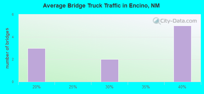
- 4,093Total average daily truck traffic
- 13,559Total future (year 2040) average daily traffic
- National Bridge Inventory (NBI) Registered Bridges for Encino
- No street view available for this location
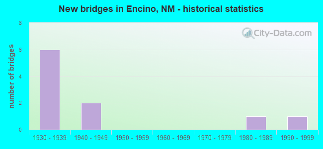
- New bridges - historical statistics
- 61930-1939
- 21940-1949
- 11980-1989
- 11990-1999
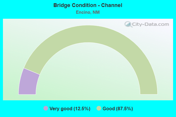
- Bridge Condition - Channel
- 12.5%Very good
- 87.5%Good
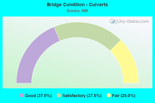
- Bridge Condition - Culverts
- 37.5%Good
- 37.5%Satisfactory
- 25.0%Fair
Find on map >> Show street view
Structure Number: 3031, Location: 3.20 M W OF JCT US 285 (Lat: 34.667256, Lng: -105.531333), Route carried "on" structure: US 60, Year Built: 1938, Status: Open, Structure Length: 6.37m (20.90ft), Average Daily Traffic: 622 (year 2020), Truck Traffic: 39%, Average Future Daily Traffic: 541 (year 2040), Design Load: H 15, Features Intersected: UNNAMED WATERWAY
Minimum Vertical Clearance: 30+ m (98+ ft), Kilometerpoint: 401.692, Lanes on structure: 2, Base Highway Network: Yes, Owner: State Highway Agency, Approaching Roadway Width: 7.3m (24.0ft), Skew: 4 degrees, Material/Design: Concrete continuous, Design/Construction: Culvert, Number Of Spans In Main Unit: 22, Length of Maximum Span: 1.8m (5.9ft)
Condition: Channel: Good, Culverts: Fair, Operating Rating: 34.0 metric tons, Method Used To Determine Operating Rating: Load Factor (LF), Inventory Rating: 24.3 metric tons, Method Used To Determine Inventory Rating: Load Factor (LF), Structural Evaluation: Somewhat better than minimum adequacy, Waterway Adequacy: Better than present minimum criteria, Approach Roadway Alignment: Equal to present desirable criteria, Length Of Structure Improvement: 6.37m (20.90ft), Designated Inspection Frequency: Every 24 months, Inspection Date: November 2020, Bridge Improvement Cost: $461,000, Roadway Improvement Cost: $46,000, Total Project Cost: $692,000 ( Estimate for 2030)
Find on map >> Show street view
Structure Number: 3032, Location: 0.40 MI E OF JCT US 285 (Lat: 34.652267, Lng: -105.470292), Route carried "on" structure: US 60, Year Built: 1938, Status: Open, Structure Length: 0.79m (2.59ft), Average Daily Traffic: 2,923 (year 2020), Truck Traffic: 16%, Average Future Daily Traffic: 2,256 (year 2040), Design Load: H 15, Features Intersected: UNNAMED WATERWAY
Minimum Vertical Clearance: 30+ m (98+ ft), Kilometerpoint: 408.006, Lanes on structure: 4, Base Highway Network: Yes, Owner: State Highway Agency, Approaching Roadway Width: 11.0m (36.1ft), Material/Design: Concrete continuous, Design/Construction: Culvert, Number Of Spans In Main Unit: 4, Length of Maximum Span: 1.8m (5.9ft)
Condition: Channel: Good, Culverts: Good, Operating Rating: 34.0 metric tons, Method Used To Determine Operating Rating: Load Factor (LF), Inventory Rating: 24.3 metric tons, Method Used To Determine Inventory Rating: Load Factor (LF), Structural Evaluation: Equal to present minimum criteria, Waterway Adequacy: Better than present minimum criteria, Approach Roadway Alignment: Equal to present desirable criteria, Length Of Structure Improvement: 0.79m (2.59ft), Designated Inspection Frequency: Every 48 months, Inspection Date: September 2019, Bridge Improvement Cost: $44,000, Roadway Improvement Cost: $4,000, Total Project Cost: $66,000 ( Estimate for 2030)
Find on map >> Show street view
Structure Number: 3033, Location: 8.2 MI W OF JCT US 285 (Lat: 34.673222, Lng: -105.617122), Route carried "on" structure: US 60, Year Built: 1939, Status: Open, Structure Length: 0.82m (2.69ft), Average Daily Traffic: 622 (year 2020), Truck Traffic: 39%, Average Future Daily Traffic: 541 (year 2040), Design Load: H 15, Features Intersected: UNNAMED WATERWAY
Minimum Vertical Clearance: 30+ m (98+ ft), Kilometerpoint: 393.806, Lanes on structure: 2, Base Highway Network: Yes, Owner: State Highway Agency, Approaching Roadway Width: 7.9m (25.9ft), Material/Design: Concrete continuous, Design/Construction: Culvert, Number Of Spans In Main Unit: 3, Length of Maximum Span: 2.4m (7.9ft)
Condition: Channel: Good, Culverts: Satisfactory, Operating Rating: 34.0 metric tons, Method Used To Determine Operating Rating: Load Factor (LF), Inventory Rating: 24.3 metric tons, Method Used To Determine Inventory Rating: Load Factor (LF), Structural Evaluation: Equal to present minimum criteria, Waterway Adequacy: Better than present minimum criteria, Approach Roadway Alignment: Equal to present desirable criteria, Designated Inspection Frequency: Every 48 months, Inspection Date: September 2019
Find on map >> Show street view
Structure Number: 3034, Location: 14.20 MI E OF JCT NM 42 (Lat: 34.659064, Lng: -105.823492), Route carried "on" structure: US 60, Year Built: 1936, Status: Open, Structure Length: 2.41m (7.91ft), Average Daily Traffic: 622 (year 2020), Truck Traffic: 39%, Average Future Daily Traffic: 541 (year 2040), Design Load: H 15, Features Intersected: UNNAMED WATERWAY
Minimum Vertical Clearance: 30+ m (98+ ft), Kilometerpoint: 374.451, Lanes on structure: 2, Base Highway Network: Yes, Owner: State Highway Agency, Approaching Roadway Width: 7.8m (25.6ft), Material/Design: Concrete continuous, Design/Construction: Culvert, Number Of Spans In Main Unit: 12, Length of Maximum Span: 1.8m (5.9ft)
Condition: Channel: Good, Culverts: Fair, Operating Rating: 32.4 metric tons, Method Used To Determine Operating Rating: Load Factor (LF), Inventory Rating: 24.3 metric tons, Method Used To Determine Inventory Rating: Load Factor (LF), Structural Evaluation: Somewhat better than minimum adequacy, Waterway Adequacy: Equal to present desirable criteria, Approach Roadway Alignment: Equal to present desirable criteria, Designated Inspection Frequency: Every 24 months, Inspection Date: November 2020
Find on map >> Show street view
Structure Number: 3035, Location: 16.4 MI E OF JCT NM 42 (Lat: 34.675278, Lng: -105.789267), Route carried "on" structure: US 60, Year Built: 1936, Status: Open, Structure Length: 0.88m (2.89ft), Average Daily Traffic: 622 (year 2020), Truck Traffic: 39%, Average Future Daily Traffic: 541 (year 2040), Design Load: H 15, Features Intersected: UNNAMED WATERWAY
Minimum Vertical Clearance: 30+ m (98+ ft), Kilometerpoint: 377.734, Lanes on structure: 2, Base Highway Network: Yes, Owner: State Highway Agency, Approaching Roadway Width: 7.8m (25.6ft), Material/Design: Concrete continuous, Design/Construction: Culvert, Number Of Spans In Main Unit: 5, Length of Maximum Span: 2.1m (6.9ft)
Condition: Channel: Very good, Culverts: Satisfactory, Operating Rating: 32.4 metric tons, Method Used To Determine Operating Rating: Load Factor (LF), Inventory Rating: 24.3 metric tons, Method Used To Determine Inventory Rating: Load Factor (LF), Structural Evaluation: Equal to present minimum criteria, Waterway Adequacy: Equal to present desirable criteria, Approach Roadway Alignment: Equal to present desirable criteria, Designated Inspection Frequency: Every 48 months, Inspection Date: September 2017
Find on map >> Show street view
Structure Number: 3036, Location: 16.0 MI W OF JCT US 285 (Lat: 34.683447, Lng: -105.755383), Route carried "on" structure: US 60, Year Built: 1936, Status: Open, Structure Length: 2.41m (7.91ft), Average Daily Traffic: 622 (year 2020), Truck Traffic: 39%, Average Future Daily Traffic: 541 (year 2040), Design Load: H 15, Features Intersected: UNNAMED WATERWAY
Minimum Vertical Clearance: 30+ m (98+ ft), Kilometerpoint: 381.093, Lanes on structure: 2, Base Highway Network: Yes, Owner: State Highway Agency, Approaching Roadway Width: 7.8m (25.6ft), Material/Design: Concrete continuous, Design/Construction: Culvert, Number Of Spans In Main Unit: 12, Length of Maximum Span: 1.8m (5.9ft)
Condition: Channel: Good, Culverts: Good, Operating Rating: 34.0 metric tons, Method Used To Determine Operating Rating: Load Factor (LF), Inventory Rating: 24.3 metric tons, Method Used To Determine Inventory Rating: Load Factor (LF), Structural Evaluation: Equal to present minimum criteria, Waterway Adequacy: Equal to present desirable criteria, Approach Roadway Alignment: Equal to present desirable criteria, Designated Inspection Frequency: Every 48 months, Inspection Date: September 2019
Find on map >> Show street view
Structure Number: 3842, Location: 14.10 MI N OF JCT US-60 (Lat: 34.838719, Lng: -105.583286), Route carried "on" structure: US 285, Year Built: 1940, Year Reconstructed: 1979, Status: Open, Structure Length: 1.61m (5.28ft), Average Daily Traffic: 2,770 (year 2020), Truck Traffic: 28%, Average Future Daily Traffic: 2,206 (year 2040), Design Load: H 15, Features Intersected: UNNAMED WATERWAY
Minimum Vertical Clearance: 30+ m (98+ ft), Kilometerpoint: 380.449, Lanes on structure: 4, Base Highway Network: Yes, Owner: State Highway Agency, Approaching Roadway Width: 24.3m (79.7ft), Skew: 10 degrees, Material/Design: Concrete continuous, Design/Construction: Culvert, Number Of Spans In Main Unit: 8, Length of Maximum Span: 1.8m (5.9ft)
Condition: Channel: Good, Culverts: Satisfactory, Operating Rating: 40.5 metric tons, Method Used To Determine Operating Rating: Load Factor (LF), Inventory Rating: 24.3 metric tons, Method Used To Determine Inventory Rating: Load Factor (LF), Structural Evaluation: Equal to present minimum criteria, Waterway Adequacy: Equal to present desirable criteria, Approach Roadway Alignment: Equal to present desirable criteria, Length Of Structure Improvement: 1.55m (5.09ft), Designated Inspection Frequency: Every 48 months, Inspection Date: Febuary 2019, Bridge Improvement Cost: $119,000, Roadway Improvement Cost: $11,000, Total Project Cost: $179,000 ( Estimate for 2030)
Find on map >> Show street view
Structure Number: 3843, Location: 11.2 MI N OF JCT US 60 (Lat: 34.858100, Lng: -105.594664), Route carried "on" structure: US 285, Year Built: 1940, Year Reconstructed: 1979, Status: Open, Structure Length: 1.01m (3.31ft), Average Daily Traffic: 2,770 (year 2020), Truck Traffic: 28%, Average Future Daily Traffic: 2,206 (year 2040), Design Load: H 15, Features Intersected: UNNAMED WATERWAY
Minimum Vertical Clearance: 30+ m (98+ ft), Kilometerpoint: 383.177, Lanes on structure: 2, Base Highway Network: Yes, Owner: State Highway Agency, Approaching Roadway Width: 12.2m (40.0ft), Material/Design: Concrete continuous, Design/Construction: Culvert, Number Of Spans In Main Unit: 3, Length of Maximum Span: 3.0m (9.8ft)
Condition: Channel: Good, Culverts: Good, Operating Rating: 89.1 metric tons, Method Used To Determine Operating Rating: Load Factor (LF), Inventory Rating: 24.3 metric tons, Method Used To Determine Inventory Rating: Load Factor (LF), Structural Evaluation: Equal to present minimum criteria, Waterway Adequacy: Equal to present desirable criteria, Approach Roadway Alignment: Equal to present desirable criteria, Length Of Structure Improvement: 1.01m (3.31ft), Designated Inspection Frequency: Every 48 months, Inspection Date: September 2019, Bridge Improvement Cost: $74,000, Roadway Improvement Cost: $7,000, Total Project Cost: $111,000 ( Estimate for 2030)
Find on map >> Show street view
Structure Number: 8555, Location: 4.30 MI E OF JCT US-285 (Lat: 34.637244, Lng: -105.404978), Route carried "on" structure: US 60, Year Built: 1985, Status: Open, Structure Length: 6.95m (22.80ft), Average Daily Traffic: 2,712 (year 2020), Truck Traffic: 16%, Average Future Daily Traffic: 2,093 (year 2040), Design Load: HS 20, Features Intersected: BNSF RAILROAD
Minimum Vertical Clearance: 30+ m (98+ ft), Kilometerpoint: 414.084, Lanes on structure: 2, Base Highway Network: Yes, Owner: State Highway Agency, Approaching Roadway Width: 12.2m (40.0ft), Skew: 4 degrees, Material/Design: Prestressed concrete continuous, Design/Construction: Stringer/Multi-beam, Number Of Spans In Main Unit: 3, Length of Maximum Span: 28.0m (91.9ft), Curb-To-Curb Width: 12.2m (40.0ft), Out-to-Out Width: 13.2m (43.3ft)
Condition: Deck: Satisfactory, Superstructure: Good, Substructure: Good, Operating Rating: 52.3 metric tons, Method Used To Determine Operating Rating: Load Factor (LF), Inventory Rating: 30.4 metric tons, Method Used To Determine Inventory Rating: Load Factor (LF), Structural Evaluation: Better than present minimum criteria, Deck Geometry: Equal to present minimum criteria, Underclear: Superior to present desirable criteria, Approach Roadway Alignment: Better than present minimum criteria, Designated Inspection Frequency: Every 24 months, Inspection Date: August 2020, Deck Structure Type: Concrete Cast-file-Place
Find on map >> Show street view
Structure Number: 9113, Location: 3.1 miles East of Encino (Lat: 34.637436, Lng: -105.405344), Route carried "on" structure: US 60, Year Built: 1999, Status: Open, Structure Length: 7.87m (25.82ft), Average Daily Traffic: 2,712 (year 2020), Truck Traffic: 16%, Average Future Daily Traffic: 2,093 (year 2040), Design Load: HS 20, Features Intersected: BNSF Railroad
Minimum Vertical Clearance: 30+ m (98+ ft), Kilometerpoint: 414.080, Lanes on structure: 2, Base Highway Network: Yes, Owner: State Highway Agency, Approaching Roadway Width: 10.7m (35.1ft), Skew: 4 degrees, Material/Design: Prestressed concrete continuous, Design/Construction: Stringer/Multi-beam, Number Of Spans In Main Unit: 3, Length of Maximum Span: 32.0m (105.0ft), Curb-To-Curb Width: 18.0m (59.1ft), Out-to-Out Width: 18.7m (61.4ft)
Condition: Deck: Satisfactory, Superstructure: Good, Substructure: Good, Operating Rating: 62.6 metric tons, Method Used To Determine Operating Rating: Load Factor (LF), Inventory Rating: 30.8 metric tons, Method Used To Determine Inventory Rating: Load Factor (LF), Structural Evaluation: Better than present minimum criteria, Deck Geometry: Superior to present desirable criteria, Underclear: Superior to present desirable criteria, Approach Roadway Alignment: Equal to present desirable criteria, Designated Inspection Frequency: Every 24 months, Inspection Date: April 2021, Deck Structure Type: Concrete Cast-file-Place, Wearing Surface/Protective System: Wearing Surface: Monolithic Concrete, Deck Protection: Epoxy Coated Reinforcing