Bridge Statistics for Epworth, Georgia (GA)
Condition, Traffic, Stress, Structural Evaluation, Project Costs
- National Bridge Inventory (NBI) Statistics
- 10Number of bridges
- 79ft / 23.8mTotal length
- $4,424,000Total costs
- 7,840Total average daily traffic
- 200Total average daily truck traffic
- 11,760Total future (year 2032) average daily traffic
- National Bridge Inventory (NBI) Registered Bridges for Epworth
- No street view available for this location
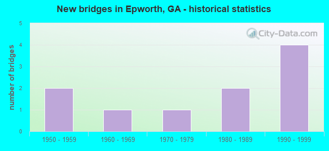
- New bridges - historical statistics
- 21950-1959
- 11960-1969
- 11970-1979
- 21980-1989
- 41990-1999
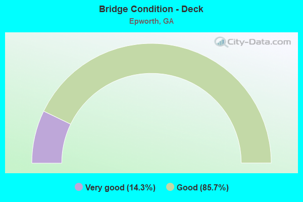
- Bridge Condition - Deck
- 14.3%Very good
- 85.7%Good

- Bridge Condition - Superstructure
- 71.4%Good
- 28.6%Satisfactory
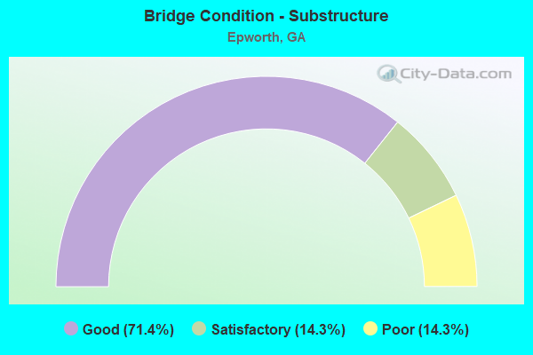
- Bridge Condition - Substructure
- 71.4%Good
- 14.3%Satisfactory
- 14.3%Poor
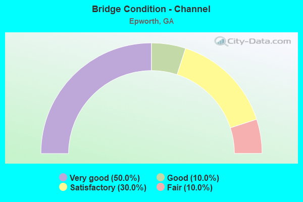
- Bridge Condition - Channel
- 50.0%Very good
- 10.0%Good
- 30.0%Satisfactory
- 10.0%Fair
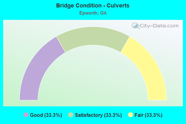
- Bridge Condition - Culverts
- 33.3%Good
- 33.3%Satisfactory
- 33.3%Fair
Find on map >> Show street view
Structure Number: 1110002, Location: 5.5 MI NW OF BLUE RIDGE (Lat: 34.895228, Lng: -84.413258), Route carried "on" structure: County highway 2329, Year Built: 1973, Status: Posted for load, Structure Length: 2.74m (8.99ft), Average Daily Traffic: 1,280 (year 2012), Truck Traffic: 5%, Average Future Daily Traffic: 1,920 (year 2032), Design Load: H 15, Features Intersected: FIGHTINGTOWN CREEK, Facility Carried by Structure: OLD S R 2
Minimum Vertical Clearance: 30+ m (98+ ft), Kilometerpoint: 8.047, Lanes on structure: 2, Base Highway Network: Yes, Owner: County Highway Agency, Approaching Roadway Width: 6.1m (20.0ft), Material/Design: Concrete, Design/Construction: Slab, Number Of Spans In Main Unit: 3, Length of Maximum Span: 9.1m (29.9ft), Curb or Sidewalk Widths: Left: 0.2m (0.7ft), Right: 0.2m (0.7ft), Curb-To-Curb Width: 7.9m (25.9ft), Out-to-Out Width: 8.2m (26.9ft)
Condition: Deck: Good, Superstructure: Good, Substructure: Good, Channel: Satisfactory, Operating Rating: 30.8 metric tons, Method Used To Determine Operating Rating: Load Factor (LF), Inventory Rating: 16.3 metric tons, Method Used To Determine Inventory Rating: Load Factor (LF), Structural Evaluation: Meets minimum limits, Deck Geometry: Meets minimum limits, Waterway Adequacy: Superior to present desirable criteria, Approach Roadway Alignment: Equal to present minimum criteria, Bridge Posting: Required (Relationship of Operating Rating to Maximum Legal Load: 10.0 - 19.9% below), Designated Inspection Frequency: Every 24 months, Inspection Date: November 2021, Bridge Improvement Cost: $352,000, Roadway Improvement Cost: $35,000, Total Project Cost: $527,000, Deck Structure Type: Concrete Precast Panels, Wearing Surface/Protective System: Wearing Surface: Bituminous
Find on map >> Show street view
Structure Number: 1110039, Location: 4.5 MI SW OF MCCAYSVILLE (Lat: 34.943239, Lng: -84.426958), Route carried "on" structure: County highway 1007, Year Built: 1956, Status: Posted for load, Structure Length: 4.57m (14.99ft), Average Daily Traffic: 1,560 (year 2012), Truck Traffic: 4%, Average Future Daily Traffic: 2,340 (year 2032), Design Load: H 15, Features Intersected: FIGHTINGTOWN CREEK, Facility Carried by Structure: MADOLA ROAD
Minimum Vertical Clearance: 30+ m (98+ ft), Kilometerpoint: 6.437, Lanes on structure: 2, Base Highway Network: Yes, Owner: County Highway Agency, Approaching Roadway Width: 5.8m (19.0ft), Material/Design: Concrete, Design/Construction: Tee Beam, Number Of Spans In Main Unit: 5, Length of Maximum Span: 9.1m (29.9ft), Curb or Sidewalk Widths: Left: 0.6m (2.0ft), Right: 0.6m (2.0ft), Curb-To-Curb Width: 7.3m (24.0ft), Out-to-Out Width: 9.0m (29.5ft)
Condition: Deck: Good, Superstructure: Good, Substructure: Poor, Channel: Satisfactory, Operating Rating: 9.0 metric tons, Method Used To Determine Operating Rating: Load Factor (LF), Inventory Rating: 4.5 metric tons, Method Used To Determine Inventory Rating: Load Factor (LF), Structural Evaluation: High priority of corrective action, Deck Geometry: Meets minimum limits, Waterway Adequacy: Superior to present desirable criteria, Approach Roadway Alignment: Equal to present desirable criteria, Bridge Posting: Required (Relationship of Operating Rating to Maximum Legal Load: > 39.9% below), Length Of Structure Improvement: 11.00m (36.09ft), Designated Inspection Frequency: Every 24 months, Other Special Inspection Frequency: Every 12 months, Inspection Date: October 2021, Other Special Inspection Date: October 2021, Bridge Improvement Cost: $586,000, Roadway Improvement Cost: $59,000, Total Project Cost: $879,000, Deck Structure Type: Concrete Cast-file-Place, Wearing Surface/Protective System: Wearing Surface: Bituminous
Find on map >> Show street view
Structure Number: 111004, Location: 4.5 MI SW OF MCCAYSVILLE (Lat: 34.942478, Lng: -84.430497), Route carried "on" structure: County highway 1007, Year Built: 1956, Status: Posted for load, Structure Length: 1.31m (4.30ft), Average Daily Traffic: 1,180 (year 2012), Truck Traffic: 1%, Average Future Daily Traffic: 1,770 (year 2032), Design Load: H 15, Features Intersected: HIGDON CREEK, Facility Carried by Structure: MADOLA ROAD
Minimum Vertical Clearance: 30+ m (98+ ft), Kilometerpoint: 6.437, Lanes on structure: 2, Base Highway Network: Yes, Owner: County Highway Agency, Approaching Roadway Width: 6.1m (20.0ft), Material/Design: Concrete, Design/Construction: Culvert, Number Of Spans In Main Unit: 4, Length of Maximum Span: 3.0m (9.8ft)
Condition: Channel: Fair, Culverts: Fair, Operating Rating: 41.7 metric tons, Method Used To Determine Operating Rating: Field evaluation and documented engineering judgment, Inventory Rating: 24.4 metric tons, Method Used To Determine Inventory Rating: Field evaluation and documented engineering judgment, Structural Evaluation: Somewhat better than minimum adequacy, Waterway Adequacy: Superior to present desirable criteria, Approach Roadway Alignment: Equal to present desirable criteria, Designated Inspection Frequency: Every 24 months, Underwater Inspection Frequency: Every 60 months, Inspection Date: November 2021, Underwater Inspection Date: July 2020, Bridge Improvement Cost: $168,000, Roadway Improvement Cost: $17,000, Total Project Cost: $252,000
Find on map >> Show street view
Structure Number: 111005, Location: 4.6 MI SW OF MCCAYSVILLE (Lat: 34.949550, Lng: -84.437878), Route carried "on" structure: County highway 1007, Year Built: 1962, Status: Open, Structure Length: 0.73m (2.40ft), Average Daily Traffic: 1,180 (year 2012), Truck Traffic: 1%, Average Future Daily Traffic: 1,770 (year 2032), Design Load: H 15, Features Intersected: DUNN MILL CREEK, Facility Carried by Structure: EPWORTH ROAD
Minimum Vertical Clearance: 30+ m (98+ ft), Kilometerpoint: 8.047, Lanes on structure: 2, Base Highway Network: Yes, Owner: County Highway Agency, Approaching Roadway Width: 7.0m (23.0ft), Skew: 3 degrees, Material/Design: Concrete, Design/Construction: Culvert, Number Of Spans In Main Unit: 2, Length of Maximum Span: 3.7m (12.1ft)
Condition: Channel: Satisfactory, Culverts: Satisfactory, Operating Rating: 41.7 metric tons, Method Used To Determine Operating Rating: Field evaluation and documented engineering judgment, Inventory Rating: 24.4 metric tons, Method Used To Determine Inventory Rating: Field evaluation and documented engineering judgment, Structural Evaluation: Equal to present minimum criteria, Waterway Adequacy: Superior to present desirable criteria, Approach Roadway Alignment: Equal to present desirable criteria, Designated Inspection Frequency: Every 24 months, Inspection Date: November 2021, Bridge Improvement Cost: $94,000, Roadway Improvement Cost: $9,000, Total Project Cost: $141,000
Find on map >> Show street view
Structure Number: 1115031, Location: 4.3 MI NW OF BLUE RIDGE (Lat: 34.902158, Lng: -84.385208), Route carried "on" structure: County highway 144, Year Built: 1990, Status: Open, Structure Length: 1.52m (4.99ft), Average Daily Traffic: 280 (year 2012), Truck Traffic: 1%, Average Future Daily Traffic: 420 (year 2032), Features Intersected: FIGHTINGTOWN CREEK, Facility Carried by Structure: POWER DAM ROAD
Minimum Vertical Clearance: 30+ m (98+ ft), Kilometerpoint: 0.000, Lanes on structure: 2, Base Highway Network: Yes, Owner: County Highway Agency, Approaching Roadway Width: 5.2m (17.1ft), Material/Design: Steel, Design/Construction: Stringer/Multi-beam, Number Of Spans In Main Unit: 1, Length of Maximum Span: 15.2m (49.9ft), Curb-To-Curb Width: 7.1m (23.3ft), Out-to-Out Width: 7.3m (24.0ft)
Condition: Deck: Good, Superstructure: Good, Substructure: Good, Channel: Very good, Operating Rating: 63.5 metric tons, Method Used To Determine Operating Rating: Load Factor (LF), Inventory Rating: 38.1 metric tons, Method Used To Determine Inventory Rating: Load Factor (LF), Structural Evaluation: Better than present minimum criteria, Deck Geometry: Meets minimum limits, Waterway Adequacy: Superior to present desirable criteria, Approach Roadway Alignment: Equal to present minimum criteria, Designated Inspection Frequency: Every 24 months, Inspection Date: November 2021, Bridge Improvement Cost: $195,000, Roadway Improvement Cost: $20,000, Total Project Cost: $293,000, Deck Structure Type: Concrete Cast-file-Place
Find on map >> Show street view
Structure Number: 1115032, Location: 5.9 MI NW OF BLUE RIDGE (Lat: 34.904008, Lng: -84.416897), Route carried "on" structure: County highway 145, Year Built: 1987, Status: Open, Structure Length: 1.37m (4.49ft), Average Daily Traffic: 490 (year 2012), Truck Traffic: 1%, Average Future Daily Traffic: 735 (year 2032), Design Load: HS 20+Mod, Features Intersected: FIGHTINGTOWN CREEK, Facility Carried by Structure: LICK SKILLET ROAD
Minimum Vertical Clearance: 30+ m (98+ ft), Kilometerpoint: 1.609, Lanes on structure: 2, Base Highway Network: Yes, Owner: County Highway Agency, Approaching Roadway Width: 6.4m (21.0ft), Skew: 2 degrees, Material/Design: Concrete, Design/Construction: Culvert, Number Of Spans In Main Unit: 4, Length of Maximum Span: 3.0m (9.8ft)
Condition: Channel: Good, Culverts: Good, Operating Rating: 55.3 metric tons, Method Used To Determine Operating Rating: Field evaluation and documented engineering judgment, Inventory Rating: 32.6 metric tons, Method Used To Determine Inventory Rating: Field evaluation and documented engineering judgment, Structural Evaluation: Better than present minimum criteria, Waterway Adequacy: Superior to present desirable criteria, Approach Roadway Alignment: Equal to present desirable criteria, Designated Inspection Frequency: Every 24 months, Inspection Date: November 2021, Bridge Improvement Cost: $176,000, Roadway Improvement Cost: $18,000, Total Project Cost: $264,000
Find on map >> Show street view
Structure Number: 1115033, Location: 5 MI SW OF MCCAYSVILLE (Lat: 34.923808, Lng: -84.410289), Route carried "on" structure: County highway 150, Year Built: 1986, Status: Open, Structure Length: 4.88m (16.01ft), Average Daily Traffic: 490 (year 2012), Truck Traffic: 1%, Average Future Daily Traffic: 735 (year 2032), Design Load: HS 15, Features Intersected: FIGHTINGTOWN CREEK, Facility Carried by Structure: McCLURE ROAD
Minimum Vertical Clearance: 30+ m (98+ ft), Kilometerpoint: 1.609, Lanes on structure: 2, Base Highway Network: Yes, Owner: County Highway Agency, Approaching Roadway Width: 6.4m (21.0ft), Material/Design: Concrete, Design/Construction: Tee Beam, Number Of Spans In Main Unit: 4, Length of Maximum Span: 12.2m (40.0ft), Curb-To-Curb Width: 8.5m (27.9ft), Out-to-Out Width: 9.5m (31.2ft)
Condition: Deck: Good, Superstructure: Good, Substructure: Satisfactory, Channel: Very good, Operating Rating: 35.3 metric tons, Method Used To Determine Operating Rating: Allowable Stress (AS), Inventory Rating: 24.4 metric tons, Method Used To Determine Inventory Rating: Allowable Stress (AS), Structural Evaluation: Equal to present minimum criteria, Deck Geometry: Somewhat better than minimum adequacy, Waterway Adequacy: Superior to present desirable criteria, Approach Roadway Alignment: Equal to present desirable criteria, Designated Inspection Frequency: Every 24 months, Inspection Date: November 2021, Bridge Improvement Cost: $625,000, Roadway Improvement Cost: $63,000, Total Project Cost: $938,000, Deck Structure Type: Concrete Cast-file-Place
Find on map >> Show street view
Structure Number: 1115052, Location: 5 MI NW OF BLUE RIDGE (Lat: 34.907200, Lng: -84.395789), Route carried "on" structure: County highway 281, Year Built: 1990, Status: Open, Structure Length: 3.05m (10.01ft), Average Daily Traffic: 490 (year 2012), Truck Traffic: 1%, Average Future Daily Traffic: 735 (year 2032), Features Intersected: FIGHTINGTOWN CREEK, Facility Carried by Structure: JULY LANE
Minimum Vertical Clearance: 30+ m (98+ ft), Kilometerpoint: 0.000, Lanes on structure: 1, Base Highway Network: Yes, Owner: County Highway Agency, Approaching Roadway Width: 4.3m (14.1ft), Material/Design: Steel, Design/Construction: Stringer/Multi-beam, Number Of Spans In Main Unit: 3, Length of Maximum Span: 12.2m (40.0ft), Curb-To-Curb Width: 4.1m (13.5ft), Out-to-Out Width: 4.3m (14.1ft)
Condition: Deck: Good, Superstructure: Good, Substructure: Good, Channel: Very good, Operating Rating: 31.7 metric tons, Method Used To Determine Operating Rating: Load Factor (LF), Inventory Rating: 15.4 metric tons, Method Used To Determine Inventory Rating: Load Factor (LF), Structural Evaluation: Meets minimum limits, Deck Geometry: High priority of replacement, Waterway Adequacy: Superior to present desirable criteria, Approach Roadway Alignment: Somewhat better than minimum adequacy, Designated Inspection Frequency: Every 24 months, Inspection Date: November 2021, Bridge Improvement Cost: $284,000, Roadway Improvement Cost: $28,000, Total Project Cost: $426,000, Deck Structure Type: Concrete Cast-file-Place
Find on map >> Show street view
Structure Number: 1115058, Location: 4 MI S OF MCCAYSVILLE (Lat: 34.931139, Lng: -84.354839), Route carried "on" structure: County highway 2332, Year Built: 1995, Status: Open, Structure Length: 1.83m (6.00ft), Average Daily Traffic: 400 (year 2012), Truck Traffic: 1%, Average Future Daily Traffic: 600 (year 2032), Features Intersected: SUGAR CREEK, Facility Carried by Structure: GALLOWAY ROAD
Minimum Vertical Clearance: 30+ m (98+ ft), Kilometerpoint: 3.219, Lanes on structure: 2, Base Highway Network: Yes, Owner: County Highway Agency, Approaching Roadway Width: 6.1m (20.0ft), Skew: 3 degrees, Material/Design: Steel, Design/Construction: Stringer/Multi-beam, Number Of Spans In Main Unit: 1, Length of Maximum Span: 18.3m (60.0ft), Curb-To-Curb Width: 6.7m (22.0ft), Out-to-Out Width: 7.2m (23.6ft)
Condition: Deck: Very good, Superstructure: Satisfactory, Substructure: Good, Channel: Very good, Operating Rating: 59.8 metric tons, Method Used To Determine Operating Rating: Load Factor (LF), Inventory Rating: 35.3 metric tons, Method Used To Determine Inventory Rating: Load Factor (LF), Structural Evaluation: Equal to present minimum criteria, Deck Geometry: Meets minimum limits, Waterway Adequacy: Superior to present desirable criteria, Approach Roadway Alignment: Equal to present minimum criteria, Designated Inspection Frequency: Every 24 months, Inspection Date: November 2021, Bridge Improvement Cost: $234,000, Roadway Improvement Cost: $23,000, Total Project Cost: $352,000, Deck Structure Type: Concrete Cast-file-Place, Wearing Surface/Protective System: Wearing Surface: Bituminous
Find on map >> Show street view
Structure Number: 1115059, Location: 4 MI NW OF BLUE RIDGE (Lat: 34.919144, Lng: -84.346922), Route carried "on" structure: County highway 116, Year Built: 1995, Status: Open, Structure Length: 1.83m (6.00ft), Average Daily Traffic: 490 (year 2012), Truck Traffic: 7%, Average Future Daily Traffic: 735 (year 2032), Features Intersected: SUGAR CREEK, Facility Carried by Structure: BARNES CHAPEL RD
Minimum Vertical Clearance: 30+ m (98+ ft), Kilometerpoint: 3.219, Lanes on structure: 2, Base Highway Network: Yes, Owner: County Highway Agency, Approaching Roadway Width: 6.4m (21.0ft), Material/Design: Steel, Design/Construction: Stringer/Multi-beam, Number Of Spans In Main Unit: 1, Length of Maximum Span: 18.3m (60.0ft), Curb-To-Curb Width: 7.4m (24.3ft), Out-to-Out Width: 8.2m (26.9ft)
Condition: Deck: Good, Superstructure: Satisfactory, Substructure: Good, Channel: Very good, Operating Rating: 52.6 metric tons, Method Used To Determine Operating Rating: Load Factor (LF), Inventory Rating: 30.8 metric tons, Method Used To Determine Inventory Rating: Load Factor (LF), Structural Evaluation: Equal to present minimum criteria, Deck Geometry: Meets minimum limits, Waterway Adequacy: Superior to present desirable criteria, Approach Roadway Alignment: Equal to present minimum criteria, Designated Inspection Frequency: Every 24 months, Inspection Date: November 2021, Bridge Improvement Cost: $234,000, Roadway Improvement Cost: $23,000, Total Project Cost: $352,000, Deck Structure Type: Concrete Cast-file-Place, Wearing Surface/Protective System: Wearing Surface: Bituminous