Bridge Statistics for Factoryville, Pennsylvania (PA)
Condition, Traffic, Stress, Structural Evaluation, Project Costs
- National Bridge Inventory (NBI) Statistics
- 16Number of bridges
- 89ft / 27.3mTotal length
- $2,810,000Total costs
- 35,088Total average daily traffic
- 3,857Total average daily truck traffic
- National Bridge Inventory (NBI) Registered Bridges for Factoryville
- No street view available for this location
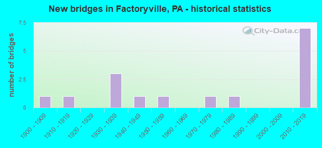
- New bridges - historical statistics
- 11900-1909
- 11910-1919
- 31930-1939
- 11940-1949
- 11950-1959
- 11970-1979
- 11980-1989
- 72010-2019
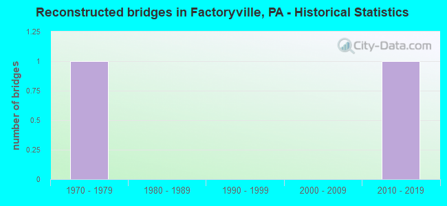
- Reconstructed bridges - Historical Statistics
- 11970-1979
- 01980-1989
- 01990-1999
- 02000-2009
- 12010-2019
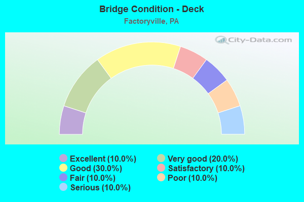
- Bridge Condition - Deck
- 10.0%Excellent
- 20.0%Very good
- 30.0%Good
- 10.0%Satisfactory
- 10.0%Fair
- 10.0%Poor
- 10.0%Serious
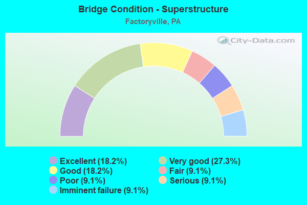
- Bridge Condition - Superstructure
- 18.2%Excellent
- 27.3%Very good
- 18.2%Good
- 9.1%Fair
- 9.1%Poor
- 9.1%Serious
- 9.1%Imminent failure
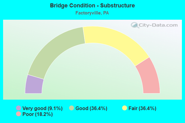
- Bridge Condition - Substructure
- 9.1%Very good
- 36.4%Good
- 36.4%Fair
- 18.2%Poor
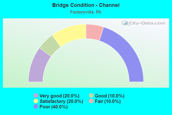
- Bridge Condition - Channel
- 20.0%Very good
- 10.0%Good
- 20.0%Satisfactory
- 10.0%Fair
- 40.0%Poor
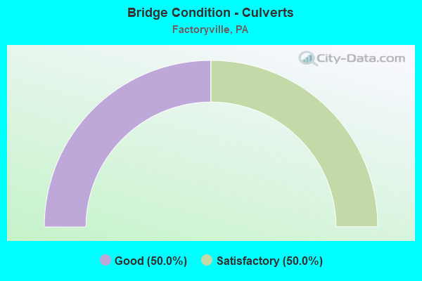
- Bridge Condition - Culverts
- 50.0%Good
- 50.0%Satisfactory
Find on map >> Show street view
Structure Number: 2036, Location: LAPLUME TWP 1 M W TR 438 (Lat: 41.563117, Lng: -75.769925), Route carried "on" structure: US 6, Year Built: 1954, Year Reconstructed: 2015, Status: Open, Structure Length: 5.94m (19.49ft), Average Daily Traffic: 9,263 (year 2021), Truck Traffic: 12%, Average Future Daily Traffic: 16,526 (year 2032), Design Load: H 20, Features Intersected: S BR TUNKHANNOCK CREEK
Minimum Vertical Clearance: 30+ m (98+ ft), Kilometerpoint: 0.000, Lanes on structure: 2, Base Highway Network: Yes, Owner: State Highway Agency, Approaching Roadway Width: 17.4m (57.1ft), Skew: 21 degrees, Material/Design: Steel, Design/Construction: Stringer/Multi-beam, Number Of Spans In Main Unit: 3, Length of Maximum Span: 20.1m (65.9ft), Curb-To-Curb Width: 23.7m (77.8ft), Out-to-Out Width: 25.0m (82.0ft)
Condition: Deck: Good, Superstructure: Very good, Substructure: Fair, Channel: Poor, Inventory Rating: 80.7 metric tons, Method Used To Determine Inventory Rating: Load Factor (LF), Structural Evaluation: Somewhat better than minimum adequacy, Deck Geometry: Superior to present desirable criteria, Waterway Adequacy: Superior to present desirable criteria, Approach Roadway Alignment: Equal to present desirable criteria, Length Of Structure Improvement: 5.91m (19.39ft), Designated Inspection Frequency: Every 24 months, Inspection Date: July 2020, Bridge Improvement Cost: $75,000, Roadway Improvement Cost: $220,000, Total Project Cost: $1,009,000, Deck Structure Type: Concrete Cast-file-Place, Wearing Surface/Protective System: Wearing Surface: Monolithic Concrete, Deck Protection: Epoxy Coated Reinforcing
Find on map >> Show street view
Structure Number: 20793, Location: BENTON TWP 1 M S SR 4004 (Lat: 41.576097, Lng: -75.760597), Route carried "on" structure: State highway , Year Built: 1915, Status: Posted for load, Structure Length: 3.90m (12.80ft), Average Daily Traffic: 284 (year 2020), Truck Traffic: 5%, Average Future Daily Traffic: 276 (year 2032), Features Intersected: NORFOLK SOUTHERN RR, Facility Carried by Structure: SR 4005 SEAMENS RD
Minimum Vertical Clearance: 30+ m (98+ ft), Kilometerpoint: 1.493, Lanes on structure: 2, Owner: Railroad, Approaching Roadway Width: 4.6m (15.1ft), Material/Design: Concrete, Design/Construction: Arch - Deck, Number Of Spans In Main Unit: 1, Number Of Approach Spans: 4, Length of Maximum Span: 24.1m (79.1ft), Curb or Sidewalk Widths: Left: 0.2m (0.7ft), Right: 0.2m (0.7ft), Curb-To-Curb Width: 7.3m (24.0ft), Out-to-Out Width: 8.5m (27.9ft)
Condition: Deck: Serious, Superstructure: Poor, Substructure: Poor, Operating Rating: 20.0 metric tons, Method Used To Determine Operating Rating: Load Factor (LF), Inventory Rating: 11.8 metric tons, Method Used To Determine Inventory Rating: Load Factor (LF), Structural Evaluation: Meets minimum limits, Deck Geometry: Somewhat better than minimum adequacy, Underclear: High priority of corrective action, Approach Roadway Alignment: Somewhat better than minimum adequacy, Bridge Posting: Required (Relationship of Operating Rating to Maximum Legal Load: > 39.9% below), Length Of Structure Improvement: 3.90m (12.80ft), Designated Inspection Frequency: Every 24 months, Other Special Inspection Frequency: Every 12 months, Inspection Date: August 2020, Other Special Inspection Date: August 2021, Bridge Improvement Cost: $24,000, Roadway Improvement Cost: $100,000, Total Project Cost: $326,000, Deck Structure Type: Concrete Cast-file-Place, Wearing Surface/Protective System: Wearing Surface: Bituminous
Find on map >> Show street view
Structure Number: 20823, Location: W ABING TWP 200' W SR4018 (Lat: 41.539722, Lng: -75.783611), Route carried "on" structure: State highway , Year Built: 1943, Status: Open, Structure Length: 0.61m (2.00ft), Average Daily Traffic: 663 (year 2020), Truck Traffic: 5%, Average Future Daily Traffic: 678 (year 2032), Design Load: H 20, Features Intersected: BR TUNKHANNOCK CREEK, Facility Carried by Structure: SR4020 L WINOLA RD
Minimum Vertical Clearance: 30+ m (98+ ft), Kilometerpoint: 0.000, Lanes on structure: 2, Owner: State Highway Agency, Approaching Roadway Width: 7.3m (24.0ft), Skew: 4 degrees, Material/Design: Concrete, Design/Construction: Culvert, Number Of Spans In Main Unit: 1, Length of Maximum Span: 6.1m (20.0ft)
Condition: Channel: Fair, Culverts: Satisfactory, Operating Rating: 49.0 metric tons, Method Used To Determine Operating Rating: Field evaluation and documented engineering judgment, Inventory Rating: 32.7 metric tons, Method Used To Determine Inventory Rating: Field evaluation and documented engineering judgment, Structural Evaluation: Equal to present minimum criteria, Waterway Adequacy: Equal to present desirable criteria, Approach Roadway Alignment: Equal to present desirable criteria, Length Of Structure Improvement: 0.70m (2.30ft), Designated Inspection Frequency: Every 24 months, Inspection Date: August 2020
Find on map >> Show street view
Structure Number: 20872, Location: LA PL TWP 100 FT EA T470 (Lat: 41.561042, Lng: -75.769689), Route carried "on" structure: City street , Year Built: 1904, Status: Closed, Structure Length: 1.28m (4.20ft), Average Future Daily Traffic: 350 (year 2038), Features Intersected: ACKERLY CREEK, Facility Carried by Structure: COLLEGE RD T437
Minimum Vertical Clearance: 30+ m (98+ ft), Kilometerpoint: 0.000, Lanes on structure: 2, Owner: County Highway Agency, Approaching Roadway Width: 4.9m (16.1ft), Material/Design: Concrete, Design/Construction: Arch - Deck, Number Of Spans In Main Unit: 1, Length of Maximum Span: 12.8m (42.0ft), Curb or Sidewalk Widths: Left: 0.5m (1.6ft), Right: 1.2m (3.9ft), Curb-To-Curb Width: 5.5m (18.0ft), Out-to-Out Width: 7.3m (24.0ft)
Condition: Superstructure: Imminent failure, Substructure: Poor, Channel: Poor, Operating Rating: 18.1 metric tons, Method Used To Determine Operating Rating: Field evaluation and documented engineering judgment, Inventory Rating: 18.1 metric tons, Method Used To Determine Inventory Rating: Field evaluation and documented engineering judgment, Deck Geometry: Meets minimum limits, Waterway Adequacy: Somewhat better than minimum adequacy, Approach Roadway Alignment: Meets minimum limits, Bridge Posting: Required (Relationship of Operating Rating to Maximum Legal Load: > 39.9% below), Length Of Structure Improvement: 1.70m (5.58ft), Designated Inspection Frequency: Every 24 months, Inspection Date: March 2020, Bridge Improvement Cost: $25,000, Roadway Improvement Cost: $73,000, Total Project Cost: $334,000, Deck Structure Type: Concrete Cast-file-Place, Wearing Surface/Protective System: Wearing Surface: Bituminous
Find on map >> Show street view
Structure Number: 20873, Location: LAPLUME, 500' WEST T-470 (Lat: 41.561025, Lng: -75.772106), Route carried "on" structure: City street , Year Built: 1986, Status: Open, Structure Length: 2.56m (8.40ft), Average Daily Traffic: 200 (year 2018), Average Future Daily Traffic: 225 (year 2035), Features Intersected: SOUTH BR TUNKHANNOCK CR, Facility Carried by Structure: T-437 (COLLEGE RD)
Minimum Vertical Clearance: 30+ m (98+ ft), Kilometerpoint: 0.000, Lanes on structure: 2, Owner: County Highway Agency, Approaching Roadway Width: 7.6m (24.9ft), Skew: 2 degrees, Material/Design: Prestressed concrete, Design/Construction: Box Beam or Girders - Multiple, Number Of Spans In Main Unit: 1, Length of Maximum Span: 24.7m (81.0ft), Curb or Sidewalk Widths: Left: 2.4m (7.9ft), Right: 0.3m (1.0ft), Curb-To-Curb Width: 7.8m (25.6ft), Out-to-Out Width: 11.0m (36.1ft)
Condition: Deck: Good, Superstructure: Good, Substructure: Good, Channel: Good, Operating Rating: 32.7 metric tons, Method Used To Determine Operating Rating: Field evaluation and documented engineering judgment, Inventory Rating: 19.1 metric tons, Method Used To Determine Inventory Rating: Field evaluation and documented engineering judgment, Structural Evaluation: Somewhat better than minimum adequacy, Deck Geometry: Somewhat better than minimum adequacy, Waterway Adequacy: Equal to present desirable criteria, Approach Roadway Alignment: Equal to present minimum criteria, Length Of Structure Improvement: 2.60m (8.53ft), Designated Inspection Frequency: Every 24 months, Inspection Date: April 2020, Bridge Improvement Cost: $3,000, Roadway Improvement Cost: $9,000, Total Project Cost: $42,000, Deck Structure Type: Concrete Cast-file-Place, Wearing Surface/Protective System: Wearing Surface: Monolithic Concrete, Deck Protection: Epoxy Coated Reinforcing
Find on map >> Show street view
Structure Number: 37159, Location: NICHOLSON TP .5M S SR1014 (Lat: 41.590058, Lng: -75.774989), Route carried "on" structure: State highway 107, Year Built: 1932, Year Reconstructed: 1983, Status: Open, Structure Length: 1.13m (3.71ft), Average Daily Traffic: 1,588 (year 2020), Truck Traffic: 9%, Average Future Daily Traffic: 2,298 (year 2032), Features Intersected: TRIB TUNKHANNOCK CREEK
Minimum Vertical Clearance: 30+ m (98+ ft), Kilometerpoint: 2.569, Lanes on structure: 2, Owner: State Highway Agency, Approaching Roadway Width: 8.5m (27.9ft), Skew: 4 degrees, Material/Design: Concrete, Design/Construction: Tee Beam, Number Of Spans In Main Unit: 1, Length of Maximum Span: 10.4m (34.1ft), Curb or Sidewalk Widths: Left: 0.2m (0.7ft), Right: 0.2m (0.7ft), Curb-To-Curb Width: 8.6m (28.2ft), Out-to-Out Width: 9.7m (31.8ft)
Condition: Deck: Satisfactory, Superstructure: Fair, Substructure: Fair, Channel: Poor, Operating Rating: 49.0 metric tons, Method Used To Determine Operating Rating: Field evaluation and documented engineering judgment, Inventory Rating: 32.7 metric tons, Method Used To Determine Inventory Rating: Field evaluation and documented engineering judgment, Structural Evaluation: Somewhat better than minimum adequacy, Deck Geometry: Somewhat better than minimum adequacy, Waterway Adequacy: Equal to present minimum criteria, Approach Roadway Alignment: Better than present minimum criteria, Length Of Structure Improvement: 1.20m (3.94ft), Designated Inspection Frequency: Every 24 months, Inspection Date: October 2021, Bridge Improvement Cost: $14,000, Roadway Improvement Cost: $100,000, Total Project Cost: $190,000, Deck Structure Type: Concrete Cast-file-Place, Wearing Surface/Protective System: Wearing Surface: Bituminous
Find on map >> Show street view
Structure Number: 37248, Location: CLINTON TWP 1.6 M S TR 6 (Lat: 41.548250, Lng: -75.813297), Route carried "on" structure: State highway , Year Built: 1930, Status: Posted for load, Structure Length: 1.10m (3.61ft), Average Daily Traffic: 256 (year 2020), Truck Traffic: 7%, Average Future Daily Traffic: 330 (year 2032), Design Load: H 20, Features Intersected: BR OF S BR TUNKHANNOCK C, Facility Carried by Structure: SR2012 LTHIA VL RD
Minimum Vertical Clearance: 30+ m (98+ ft), Kilometerpoint: 2.548, Lanes on structure: 2, Owner: State Highway Agency, Approaching Roadway Width: 6.7m (22.0ft), Skew: 4 degrees, Material/Design: Steel, Design/Construction: Stringer/Multi-beam, Number Of Spans In Main Unit: 1, Length of Maximum Span: 10.4m (34.1ft), Curb or Sidewalk Widths: Left: 0.2m (0.7ft), Right: 0.2m (0.7ft), Curb-To-Curb Width: 7.0m (23.0ft), Out-to-Out Width: 8.0m (26.2ft)
Condition: Deck: Poor, Superstructure: Serious, Substructure: Fair, Channel: Poor, Operating Rating: 23.6 metric tons, Method Used To Determine Operating Rating: Load Factor (LF), Inventory Rating: 14.5 metric tons, Method Used To Determine Inventory Rating: Load Factor (LF), Structural Evaluation: High priority of corrective action, Deck Geometry: Meets minimum limits, Waterway Adequacy: Equal to present desirable criteria, Approach Roadway Alignment: Better than present minimum criteria, Bridge Posting: Required (Relationship of Operating Rating to Maximum Legal Load: > 39.9% below), Length Of Structure Improvement: 1.40m (4.59ft), Designated Inspection Frequency: Every 24 months, Other Special Inspection Frequency: Every 6 months, Inspection Date: June 2020, Other Special Inspection Date: June 2021, Bridge Improvement Cost: $37,000, Roadway Improvement Cost: $193,000, Total Project Cost: $498,000, Deck Structure Type: Open Grating
Find on map >> Show street view
Structure Number: 3725, Location: CLINTON TWP .2M W SR 2014 (Lat: 41.545094, Lng: -75.792294), Route carried "on" structure: State highway , Year Built: 1930, Status: Open, Structure Length: 0.76m (2.49ft), Average Daily Traffic: 256 (year 2020), Truck Traffic: 7%, Average Future Daily Traffic: 330 (year 2032), Design Load: HL 93, Features Intersected: TRIB S BR TUNKHANNOCK CK, Facility Carried by Structure: SR 2012
Minimum Vertical Clearance: 30+ m (98+ ft), Kilometerpoint: 4.545, Lanes on structure: 2, Owner: State Highway Agency, Approaching Roadway Width: 6.1m (20.0ft), Skew: 3 degrees, Material/Design: Steel, Design/Construction: Stringer/Multi-beam, Number Of Spans In Main Unit: 1, Length of Maximum Span: 7.3m (24.0ft), Curb or Sidewalk Widths: Left: 0.2m (0.7ft), Right: 0.2m (0.7ft), Curb-To-Curb Width: 7.1m (23.3ft), Out-to-Out Width: 7.6m (24.9ft)
Condition: Deck: Very good, Superstructure: Very good, Substructure: Fair, Channel: Satisfactory, Operating Rating: 82.0 metric tons, Method Used To Determine Operating Rating: Assigned ratings based on Load and Resistance Factor Design (LRFD) reported by rating factor (RF) using HL93 loadings, Inventory Rating: 63.2 metric tons, Method Used To Determine Inventory Rating: Assigned ratings based on Load and Resistance Factor Design (LRFD) reported by rating factor (RF) using HL93 loadings, Structural Evaluation: Somewhat better than minimum adequacy, Deck Geometry: Meets minimum limits, Waterway Adequacy: Better than present minimum criteria, Approach Roadway Alignment: Equal to present desirable criteria, Length Of Structure Improvement: 0.80m (2.62ft), Designated Inspection Frequency: Every 24 months, Inspection Date: November 2019, Bridge Improvement Cost: $15,000, Roadway Improvement Cost: $100,000, Total Project Cost: $200,000, Deck Structure Type: Wood or Timber
Find on map >> Show street view
Structure Number: 37263, Location: FACTRYVL BO 100' S SR1017 (Lat: 41.563619, Lng: -75.782889), Route carried "on" structure: State highway , Year Built: 1973, Status: Open, Structure Length: 2.50m (8.20ft), Average Daily Traffic: 689 (year 2020), Truck Traffic: 5%, Average Future Daily Traffic: 1,096 (year 2032), Design Load: HS 20, Features Intersected: S BR TUNKHANNOCK CREEK, Facility Carried by Structure: SR 2033 CHURCH ST
Minimum Vertical Clearance: 30+ m (98+ ft), Kilometerpoint: 0.187, Lanes on structure: 2, Owner: State Highway Agency, Approaching Roadway Width: 7.9m (25.9ft), Material/Design: Prestressed concrete, Design/Construction: Box Beam or Girders - Multiple, Number Of Spans In Main Unit: 1, Length of Maximum Span: 24.4m (80.1ft), Curb or Sidewalk Widths: Left: 1.5m (4.9ft), Right: 1.5m (4.9ft), Curb-To-Curb Width: 7.9m (25.9ft), Out-to-Out Width: 11.7m (38.4ft)
Condition: Deck: Fair, Superstructure: Good, Substructure: Good, Channel: Very good, Operating Rating: 84.4 metric tons, Method Used To Determine Operating Rating: Load Factor (LF), Inventory Rating: 22.7 metric tons, Method Used To Determine Inventory Rating: Load Factor (LF), Structural Evaluation: Equal to present minimum criteria, Deck Geometry: Somewhat better than minimum adequacy, Waterway Adequacy: Better than present minimum criteria, Approach Roadway Alignment: Equal to present desirable criteria, Length Of Structure Improvement: 2.50m (8.20ft), Designated Inspection Frequency: Every 24 months, Inspection Date: November 2019, Bridge Improvement Cost: $16,000, Roadway Improvement Cost: $100,000, Total Project Cost: $211,000, Deck Structure Type: Concrete Cast-file-Place, Wearing Surface/Protective System: Wearing Surface: Monolithic Concrete
Find on map >> Show street view
Structure Number: 52762, Location: LA PL TWP 100 FT SO 4005 (Lat: 41.568542, Lng: -75.768011), Route carried "on" structure: County highway , Year Built: 2015, Status: Open, Structure Length: 2.47m (8.10ft), Average Daily Traffic: 327 (year 2017), Truck Traffic: 1%, Average Future Daily Traffic: 409 (year 2037), Design Load: HL 93, Features Intersected: SO BR TUNKHANNOCK CREEK, Facility Carried by Structure: T470 NO OVERBRK RD
Minimum Vertical Clearance: 30+ m (98+ ft), Kilometerpoint: 0.000, Lanes on structure: 2, Owner: County Highway Agency, Approaching Roadway Width: 7.3m (24.0ft), Material/Design: Prestressed concrete, Design/Construction: Box Beam or Girders - Single/Spread, Number Of Spans In Main Unit: 1, Length of Maximum Span: 24.1m (79.1ft), Curb or Sidewalk Widths: Left: 0.2m (0.7ft), Right: 0.2m (0.7ft), Curb-To-Curb Width: 7.3m (24.0ft), Out-to-Out Width: 8.4m (27.6ft)
Condition: Deck: Very good, Superstructure: Excellent, Substructure: Good, Channel: Very good, Operating Rating: 63.5 metric tons, Method Used To Determine Operating Rating: Assigned ratings based on Load and Resistance Factor Design (LRFD) reported by rating factor (RF) using HL93 loadings, Inventory Rating: 34.7 metric tons, Method Used To Determine Inventory Rating: Assigned ratings based on Load and Resistance Factor Design (LRFD) reported by rating factor (RF) using HL93 loadings, Structural Evaluation: Better than present minimum criteria, Deck Geometry: Somewhat better than minimum adequacy, Waterway Adequacy: Superior to present desirable criteria, Approach Roadway Alignment: Equal to present desirable criteria, Designated Inspection Frequency: Every 24 months, Inspection Date: December 2019, Deck Structure Type: Concrete Cast-file-Place, Wearing Surface/Protective System: Wearing Surface: Monolithic Concrete, Membrane: Epoxy, Deck Protection: Epoxy Coated Reinforcing
Find on map >> Show street view
Structure Number: 52846, Location: CLINTON TWP OVER TR 6 (Lat: 41.569311, Lng: -75.798292), Route carried "on" structure: US 11, Year Built: 2015, Status: Open, Structure Length: 2.71m (8.89ft), Average Daily Traffic: 3,709 (year 2020), Truck Traffic: 11%, Average Future Daily Traffic: 5,035 (year 2032), Design Load: HL 93, Features Intersected: TR 6 W, SR 8002 TO 11N
Minimum Vertical Clearance: 30+ m (98+ ft), Kilometerpoint: 0.441, Lanes on structure: 2, Lanes under structure: 4, Owner: State Highway Agency, Approaching Roadway Width: 10.4m (34.1ft), Skew: 5 degrees, Material/Design: Prestressed concrete, Design/Construction: Stringer/Multi-beam, Number Of Spans In Main Unit: 1, Length of Maximum Span: 25.9m (85.0ft), Curb or Sidewalk Widths: Left: 0.2m (0.7ft), Right: 0.2m (0.7ft), Curb-To-Curb Width: 12.2m (40.0ft), Out-to-Out Width: 13.2m (43.3ft)
Condition: Deck: Excellent, Superstructure: Excellent, Substructure: Very good, Operating Rating: 67.1 metric tons, Method Used To Determine Operating Rating: Assigned ratings based on Load and Resistance Factor Design (LRFD) reported by rating factor (RF) using HL93 loadings, Inventory Rating: 38.2 metric tons, Method Used To Determine Inventory Rating: Assigned ratings based on Load and Resistance Factor Design (LRFD) reported by rating factor (RF) using HL93 loadings, Structural Evaluation: Equal to present desirable criteria, Deck Geometry: Equal to present minimum criteria, Underclear: Meets minimum limits, Approach Roadway Alignment: Better than present minimum criteria, Designated Inspection Frequency: Every 24 months, Inspection Date: December 2019, Deck Structure Type: Concrete Cast-file-Place, Wearing Surface/Protective System: Wearing Surface: Monolithic Concrete, Deck Protection: Epoxy Coated Reinforcing
Find on map >> Show street view
Structure Number: 53703, Location: CLINTON TWP OVER SR 1017 (Lat: 41.569772, Lng: -75.788422), Route carried "on" structure: US 6, Year Built: 2016, Status: Open, Structure Length: 1.49m (4.89ft), Average Daily Traffic: 9,672 (year 2021), Truck Traffic: 13%, Average Future Daily Traffic: 13,313 (year 2038), Design Load: HL 93, Features Intersected: SR 1017 (COLLEGE AVE)
Minimum Vertical Clearance: 30+ m (98+ ft), Kilometerpoint: 43.259, Lanes on structure: 2, Lanes under structure: 2, Base Highway Network: Yes, Owner: State Highway Agency, Approaching Roadway Width: 19.8m (65.0ft), Skew: 21 degrees, Material/Design: Prestressed concrete, Design/Construction: Box Beam or Girders - Single/Spread, Number Of Spans In Main Unit: 1, Length of Maximum Span: 14.3m (46.9ft), Curb or Sidewalk Widths: Left: 0.2m (0.7ft), Right: 0.2m (0.7ft), Curb-To-Curb Width: 20.7m (67.9ft), Out-to-Out Width: 21.8m (71.5ft)
Condition: Deck: Good, Superstructure: Very good, Substructure: Good, Operating Rating: 55.7 metric tons, Method Used To Determine Operating Rating: Assigned ratings based on Load and Resistance Factor Design (LRFD) reported by rating factor (RF) using HL93 loadings, Inventory Rating: 35.0 metric tons, Method Used To Determine Inventory Rating: Assigned ratings based on Load and Resistance Factor Design (LRFD) reported by rating factor (RF) using HL93 loadings, Structural Evaluation: Better than present minimum criteria, Deck Geometry: Superior to present desirable criteria, Underclear: Meets minimum limits, Approach Roadway Alignment: Equal to present desirable criteria, Designated Inspection Frequency: Every 48 months, Inspection Date: December 2018, Deck Structure Type: Concrete Cast-file-Place, Wearing Surface/Protective System: Wearing Surface: Monolithic Concrete, Deck Protection: Epoxy Coated Reinforcing
Find on map >> Show street view
Structure Number: 54508, Location: FACTORYVL BO .1M S TR 6 (Lat: 41.567694, Lng: -75.787000), Route carried "on" structure: State highway , Year Built: 2017, Status: Open, Structure Length: 0.82m (2.69ft), Average Daily Traffic: 1,537 (year 2020), Truck Traffic: 3%, Average Future Daily Traffic: 1,749 (year 2032), Design Load: HL 93, Features Intersected: TRIB S B TUNKHANNOCK CRK, Facility Carried by Structure: SR 1017 COLLEGE AV
Minimum Vertical Clearance: 30+ m (98+ ft), Kilometerpoint: 0.792, Lanes on structure: 2, Owner: State Highway Agency, Approaching Roadway Width: 8.5m (27.9ft), Material/Design: Concrete, Design/Construction: Culvert, Number Of Spans In Main Unit: 1, Length of Maximum Span: 7.6m (24.9ft), Curb or Sidewalk Widths: Left: 0.5m (1.6ft), Right: 0.5m (1.6ft), Curb-To-Curb Width: 10.4m (34.1ft), Out-to-Out Width: 13.1m (43.0ft)
Condition: Channel: Satisfactory, Culverts: Good, Operating Rating: 45.7 metric tons, Method Used To Determine Operating Rating: Assigned ratings based on Load and Resistance Factor Design (LRFD) reported by rating factor (RF) using HL93 loadings, Inventory Rating: 34.3 metric tons, Method Used To Determine Inventory Rating: Assigned ratings based on Load and Resistance Factor Design (LRFD) reported by rating factor (RF) using HL93 loadings, Structural Evaluation: Better than present minimum criteria, Deck Geometry: Equal to present minimum criteria, Waterway Adequacy: Equal to present minimum criteria, Approach Roadway Alignment: Equal to present desirable criteria, Designated Inspection Frequency: Every 48 months, Inspection Date: October 2021, Wearing Surface/Protective System: Wearing Surface: Bituminous
Find on map >> Show street view
Structure Number: 52846, Location: CLINTON TWP OVER TR 6 (Lat: 41.569311, Lng: -75.798292), Route carried "under" structure: US 6, Year Built: 2015, Structure Length: 0. m, Average Daily Traffic: 4,662 (year 2021), Truck Traffic: 15%, Features Intersected: TR 6 W, SR 8002 TO 11N, Facility Carried by Structure: SR 0011 TR 11
Minimum Vertical Clearance: 4.57m (14.99ft), Kilometerpoint: 42.231, Lanes on structure: 2, Lanes under structure: 2, Material/Design: Prestressed concrete, Design/Construction: Stringer/Multi-beam, Length of Maximum Span: 25.9m (85.0ft)
Find on map >> Show street view
Structure Number: 52846, Location: CLINTON TWP OVER TR 6 (Lat: 41.569311, Lng: -75.798292), Route carried "under" structure: Ramp State highway , Year Built: 2015, Structure Length: 0. m, Average Daily Traffic: 445 (year 2022), Truck Traffic: 7%, Features Intersected: TR 6 W, SR 8002 TO 11N, Facility Carried by Structure: SR 0011 TR 11
Minimum Vertical Clearance: 5.06m (16.60ft), Kilometerpoint: 0.000, Lanes on structure: 2, Lanes under structure: 2, Material/Design: Prestressed concrete, Design/Construction: Stringer/Multi-beam, Length of Maximum Span: 25.9m (85.0ft)
Find on map >> Show street view
Structure Number: 53703, Location: CLINTON TWP OVER SR 1017 (Lat: 41.569772, Lng: -75.788422), Route carried "under" structure: State highway , Year Built: 2016, Structure Length: 0. m, Average Daily Traffic: 1,537 (year 2020), Truck Traffic: 3%, Features Intersected: SR 1017 (COLLEGE AVE), Facility Carried by Structure: SR 0006 TR 6 & 11
Minimum Vertical Clearance: 4.54m (14.90ft), Kilometerpoint: 1.590, Lanes on structure: 2, Lanes under structure: 2, Material/Design: Prestressed concrete, Design/Construction: Box Beam or Girders - Single/Spread, Length of Maximum Span: 14.3m (46.9ft)