Bridge Statistics for Fairfield, Alabama (AL)
Condition, Traffic, Stress, Structural Evaluation, Project Costs
- National Bridge Inventory (NBI) Statistics
- 32Number of bridges
- 417ft / 127mTotal length
- $47,907,000Total costs
- 687,203Total average daily traffic
- 88,575Total average daily truck traffic
- National Bridge Inventory (NBI) Registered Bridges for Fairfield
- No street view available for this location
- New bridges - historical statistics
- 21920-1929
- 11930-1939
- 41940-1949
- 191960-1969
- 61980-1989
- Reconstructed bridges - Historical Statistics
- 31980-1989
- 01990-1999
- 12000-2009
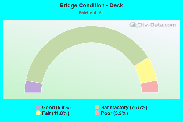
- Bridge Condition - Deck
- 5.9%Good
- 76.5%Satisfactory
- 11.8%Fair
- 5.9%Poor
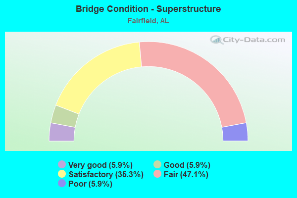
- Bridge Condition - Superstructure
- 5.9%Very good
- 5.9%Good
- 35.3%Satisfactory
- 47.1%Fair
- 5.9%Poor
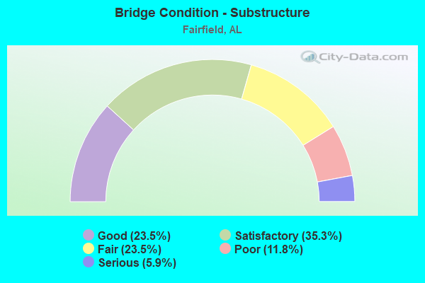
- Bridge Condition - Substructure
- 23.5%Good
- 35.3%Satisfactory
- 23.5%Fair
- 11.8%Poor
- 5.9%Serious
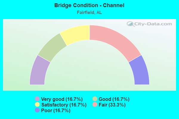
- Bridge Condition - Channel
- 16.7%Very good
- 16.7%Good
- 16.7%Satisfactory
- 33.3%Fair
- 16.7%Poor
Find on map >> Show street view
Structure Number: 312, Location: 841 FT E JCT 79 (Lat: 34.291800, Lng: -86.353400), Route carried "on" structure: County highway 175, Year Built: 1925, Status: Closed, Structure Length: 2.13m (6.99ft), Average Daily Traffic: 30 (year 1994), Average Future Daily Traffic: 35 (year 2020), Design Load: H 10, Features Intersected: BIG SPRING CREEK
Minimum Vertical Clearance: 30+ m (98+ ft), Kilometerpoint: 0.010, Lanes on structure: 1, Owner: County Highway Agency, Approaching Roadway Width: 7.3m (24.0ft), Material/Design: Steel, Design/Construction: Stringer/Multi-beam, Number Of Spans In Main Unit: 4, Length of Maximum Span: 6.4m (21.0ft), Curb-To-Curb Width: 3.5m (11.5ft), Out-to-Out Width: 3.5m (11.5ft)
Condition: Deck: Poor, Superstructure: Fair, Substructure: Poor, Channel: Satisfactory, Deck Geometry: High priority of corrective action, Waterway Adequacy: Equal to present desirable criteria, Approach Roadway Alignment: Better than present minimum criteria, Bridge Posting: Required (Relationship of Operating Rating to Maximum Legal Load: > 39.9% below), Length Of Structure Improvement: 2.91m (9.55ft), Designated Inspection Frequency: Every 24 months, Other Special Inspection Frequency: Every 12 months, Inspection Date: July 1998, Other Special Inspection Date: July 1999, Bridge Improvement Cost: $220,000, Roadway Improvement Cost: $22,000, Total Project Cost: $242,000 ( Estimate for 2022), Deck Structure Type: Wood or Timber, Wearing Surface/Protective System: Wearing Surface: Wood or Timber
Find on map >> Show street view
Structure Number: 319, Location: 0.5 M N OF RD NO 048 (Lat: 32.853842, Lng: -85.628828), Route carried "on" structure: County highway 436, Year Built: 1925, Status: Posted for load, Structure Length: 4.72m (15.49ft), Average Daily Traffic: 75 (year 2008), Average Future Daily Traffic: 95 (year 2030), Design Load: H 10, Features Intersected: ANDREWS BRANCH, Facility Carried by Structure: LANGLEY RD
Minimum Vertical Clearance: 30+ m (98+ ft), Kilometerpoint: 0.010, Lanes on structure: 1, Owner: County Highway Agency, Approaching Roadway Width: 4.9m (16.1ft), Material/Design: Steel, Design/Construction: Stringer/Multi-beam, Number Of Spans In Main Unit: 1, Number Of Approach Spans: 3, Length of Maximum Span: 12.2m (40.0ft), Curb-To-Curb Width: 3.7m (12.1ft), Out-to-Out Width: 4.0m (13.1ft)
Condition: Deck: Satisfactory, Superstructure: Fair, Substructure: Fair, Channel: Fair, Operating Rating: 10.5 metric tons, Method Used To Determine Operating Rating: Allowable Stress (AS), Inventory Rating: 7.8 metric tons, Method Used To Determine Inventory Rating: Allowable Stress (AS), Structural Evaluation: High priority of replacement, Deck Geometry: Meets minimum limits, Waterway Adequacy: Somewhat better than minimum adequacy, Approach Roadway Alignment: Somewhat better than minimum adequacy, Bridge Posting: Required (Relationship of Operating Rating to Maximum Legal Load: > 39.9% below), Length Of Structure Improvement: 5.73m (18.80ft), Designated Inspection Frequency: Every 24 months, Other Special Inspection Frequency: Every 12 months, Inspection Date: December 2020, Other Special Inspection Date: December 2021, Bridge Improvement Cost: $510,000, Roadway Improvement Cost: $51,000, Total Project Cost: $561,000 ( Estimate for 2022), Deck Structure Type: Wood or Timber, Wearing Surface/Protective System: Wearing Surface: Wood or Timber
Find on map >> Show street view
Structure Number: 1322, Location: TERRACE G * 38 TH ST (Lat: 33.516667, Lng: -86.903333), Route carried "on" structure: City street , Year Built: 1935, Status: Posted for load, Structure Length: 0.64m (2.10ft), Average Daily Traffic: 40 (year 2020), Average Future Daily Traffic: 50 (year 2040), Design Load: H 10, Features Intersected: DRAINAGE DITCH, Facility Carried by Structure: TERRACE G
Minimum Vertical Clearance: 30+ m (98+ ft), Kilometerpoint: 0.100, Lanes on structure: 1, Owner: City or Municipal Highway Agency, Approaching Roadway Width: 3.4m (11.2ft), Material/Design: Steel, Design/Construction: Stringer/Multi-beam, Number Of Spans In Main Unit: 1, Length of Maximum Span: 6.4m (21.0ft), Curb-To-Curb Width: 4.1m (13.5ft), Out-to-Out Width: 4.7m (15.4ft)
Condition: Deck: Satisfactory, Superstructure: Fair, Substructure: Good, Channel: Very good, Operating Rating: 18.4 metric tons, Method Used To Determine Operating Rating: Allowable Stress (AS), Inventory Rating: 13.8 metric tons, Method Used To Determine Inventory Rating: Allowable Stress (AS), Structural Evaluation: Meets minimum limits, Deck Geometry: Somewhat better than minimum adequacy, Waterway Adequacy: Equal to present minimum criteria, Approach Roadway Alignment: Meets minimum limits, Bridge Posting: Required (Relationship of Operating Rating to Maximum Legal Load: > 39.9% below), Length Of Structure Improvement: 1.26m (4.13ft), Designated Inspection Frequency: Every 24 months, Other Special Inspection Frequency: Every 12 months, Inspection Date: November 2020, Other Special Inspection Date: November 2021, Bridge Improvement Cost: $130,000, Roadway Improvement Cost: $13,000, Total Project Cost: $143,000 ( Estimate for 2022), Deck Structure Type: Wood or Timber, Wearing Surface/Protective System: Wearing Surface: Wood or Timber
Find on map >> Show street view
Structure Number: 3191, Location: 0.2 M E Mooresville Rd (Lat: 34.696528, Lng: -86.873944), Route carried "on" structure: State lands road 4, Year Built: 1948, Status: Posted for load, Structure Length: 1.92m (6.30ft), Average Daily Traffic: 35 (year 2022), Average Future Daily Traffic: 49 (year 2035), Design Load: H 10, Features Intersected: LIMESTONE CREEK
Minimum Vertical Clearance: 30+ m (98+ ft), Kilometerpoint: 19.999, Lanes on structure: 1, Owner: State Highway Agency, Approaching Roadway Width: 4.3m (14.1ft), Material/Design: Steel, Design/Construction: Truss - Thru, Number Of Spans In Main Unit: 1, Length of Maximum Span: 19.2m (63.0ft), Curb-To-Curb Width: 4.2m (13.8ft), Out-to-Out Width: 5.5m (18.0ft)
Condition: Deck: Satisfactory, Superstructure: Poor, Substructure: Fair, Channel: Poor, Operating Rating: 4.5 metric tons, Method Used To Determine Operating Rating: Load Factor (LF), Inventory Rating: 2.7 metric tons, Method Used To Determine Inventory Rating: Load Factor (LF), Structural Evaluation: High priority of replacement, Deck Geometry: Somewhat better than minimum adequacy, Waterway Adequacy: Somewhat better than minimum adequacy, Approach Roadway Alignment: Equal to present minimum criteria, Bridge Posting: Required (Relationship of Operating Rating to Maximum Legal Load: > 39.9% below), Length Of Structure Improvement: 2.65m (8.69ft), Designated Inspection Frequency: Every 24 months, Critical Feature Inspection Frequency: Every 12 months, Other Special Inspection Frequency: Every 12 months, Inspection Date: January 2021, Critical Feature Inspection Date: January 2022, Other Special Inspection Date: January 2022, Bridge Improvement Cost: $309,000, Roadway Improvement Cost: $31,000, Total Project Cost: $340,000 ( Estimate for 2022), Deck Structure Type: Concrete Cast-file-Place
Find on map >> Show street view
Structure Number: 3192, Location: CO RD 33 TO ALA 95 (Lat: 31.198764, Lng: -85.135033), Route carried "on" structure: County highway 6, Year Built: 1948, Year Reconstructed: 2005, Status: Posted for load, Structure Length: 2.77m (9.09ft), Average Daily Traffic: 10 (year 1993), Average Future Daily Traffic: 30 (year 2033), Features Intersected: JACKSON CREEK, Facility Carried by Structure: LAMP BRO. RD
Minimum Vertical Clearance: 30+ m (98+ ft), Kilometerpoint: 0.010, Lanes on structure: 1, Owner: County Highway Agency, Approaching Roadway Width: 8.5m (27.9ft), Material/Design: Wood or Timber, Design/Construction: Stringer/Multi-beam, Number Of Spans In Main Unit: 6, Length of Maximum Span: 4.6m (15.1ft), Curb-To-Curb Width: 5.3m (17.4ft), Out-to-Out Width: 5.6m (18.4ft)
Condition: Deck: Good, Superstructure: Very good, Substructure: Good, Channel: Good, Operating Rating: 36.2 metric tons, Method Used To Determine Operating Rating: Allowable Stress (AS), Inventory Rating: 26.5 metric tons, Method Used To Determine Inventory Rating: Allowable Stress (AS), Structural Evaluation: Equal to present minimum criteria, Deck Geometry: High priority of corrective action, Waterway Adequacy: Better than present minimum criteria, Approach Roadway Alignment: Better than present minimum criteria, Bridge Posting: Required (Relationship of Operating Rating to Maximum Legal Load: 10.0 - 19.9% below), Length Of Structure Improvement: 3.69m (12.11ft), Designated Inspection Frequency: Every 24 months, Other Special Inspection Frequency: Every 12 months, Inspection Date: June 2021, Other Special Inspection Date: June 2021, Bridge Improvement Cost: $456,000, Roadway Improvement Cost: $46,000, Total Project Cost: $502,000 ( Estimate for 2022), Deck Structure Type: Wood or Timber, Wearing Surface/Protective System: Wearing Surface: Wood or Timber
Find on map >> Show street view
Structure Number: 3194, Location: 4.0 MI. S. VREDENBURGH (Lat: 31.757919, Lng: -87.295031), Route carried "on" structure: County highway 1, Year Built: 1948, Status: Posted for load, Structure Length: 3.41m (11.19ft), Average Daily Traffic: 80 (year 1993), Truck Traffic: 20%, Average Future Daily Traffic: 150 (year 2033), Features Intersected: BIG FLAT CREEK, Facility Carried by Structure: COUNTY ROUTE 6
Minimum Vertical Clearance: 30+ m (98+ ft), Kilometerpoint: 0.010, Lanes on structure: 1, Owner: County Highway Agency, Approaching Roadway Width: 5.2m (17.1ft), Material/Design: Wood or Timber, Design/Construction: Stringer/Multi-beam, Number Of Spans In Main Unit: 8, Length of Maximum Span: 4.9m (16.1ft), Curb-To-Curb Width: 3.2m (10.5ft), Out-to-Out Width: 4.9m (16.1ft)
Condition: Deck: Fair, Superstructure: Satisfactory, Substructure: Serious, Channel: Fair, Operating Rating: 2.7 metric tons, Method Used To Determine Operating Rating: Allowable Stress (AS), Inventory Rating: 1.8 metric tons, Method Used To Determine Inventory Rating: Allowable Stress (AS), Structural Evaluation: High priority of replacement, Deck Geometry: High priority of replacement, Waterway Adequacy: Meets minimum limits, Approach Roadway Alignment: Somewhat better than minimum adequacy, Bridge Posting: Required (Relationship of Operating Rating to Maximum Legal Load: > 39.9% below), Length Of Structure Improvement: 4.30m (14.11ft), Designated Inspection Frequency: Every 24 months, Other Special Inspection Frequency: Every 3 months, Inspection Date: Febuary 2021, Other Special Inspection Date: Febuary 2022, Bridge Improvement Cost: $472,000, Roadway Improvement Cost: $47,000, Total Project Cost: $519,000 ( Estimate for 2022), Deck Structure Type: Wood or Timber, Wearing Surface/Protective System: Wearing Surface: Wood or Timber
Find on map >> Show street view
Structure Number: 3197, Location: CITY OF GOODWATER (Lat: 33.066083, Lng: -86.053472), Route carried "on" structure: State highway 9, Year Built: 1948, Status: Open, Structure Length: 2.54m (8.33ft), Average Daily Traffic: 4,356 (year 2018), Truck Traffic: 4%, Average Future Daily Traffic: 6,098 (year 2038), Design Load: H 20, Features Intersected: NORFOLK SOUTHERN R/R
Minimum Vertical Clearance: 30+ m (98+ ft), Kilometerpoint: 261.283, Lanes on structure: 2, Base Highway Network: Yes, Owner: State Highway Agency, Approaching Roadway Width: 15.8m (51.8ft), Skew: 4 degrees, Material/Design: Concrete, Design/Construction: Tee Beam, Number Of Spans In Main Unit: 3, Length of Maximum Span: 13.1m (43.0ft), Curb or Sidewalk Widths: Left: 1.4m (4.6ft), Right: 1.4m (4.6ft), Curb-To-Curb Width: 12.1m (39.7ft), Out-to-Out Width: 15.4m (50.5ft)
Condition: Deck: Fair, Superstructure: Good, Substructure: Satisfactory, Operating Rating: 44.3 metric tons, Method Used To Determine Operating Rating: Load Factor (LF), Inventory Rating: 26.5 metric tons, Method Used To Determine Inventory Rating: Load Factor (LF), Structural Evaluation: Equal to present minimum criteria, Deck Geometry: Somewhat better than minimum adequacy, Underclear: Meets minimum limits, Approach Roadway Alignment: Meets minimum limits, Length Of Structure Improvement: 3.43m (11.25ft), Designated Inspection Frequency: Every 24 months, Inspection Date: May 2020, Bridge Improvement Cost: $1,176,000, Roadway Improvement Cost: $118,000, Total Project Cost: $1,294,000 ( Estimate for 2022), Deck Structure Type: Concrete Cast-file-Place
Find on map >> Show street view
Structure Number: 9514, Location: @ TCI WIRE MILL (Lat: 33.472600, Lng: -86.931200), Route carried "on" structure: County highway , Year Built: 1968, Status: Open, Structure Length: 9.94m (32.61ft), Average Daily Traffic: 500 (year 2020), Truck Traffic: 2%, Average Future Daily Traffic: 900 (year 2040), Design Load: HS 20, Features Intersected: I 59/20, Facility Carried by Structure: WIRE MILL ROAD
Minimum Vertical Clearance: 30+ m (98+ ft), Kilometerpoint: 0.010, Lanes on structure: 2, Lanes under structure: 4, Owner: State Highway Agency, Approaching Roadway Width: 8.5m (27.9ft), Skew: 3 degrees, Material/Design: Steel continuous, Design/Construction: Stringer/Multi-beam, Number Of Spans In Main Unit: 4, Number Of Approach Spans: 1, Length of Maximum Span: 25.9m (85.0ft), Curb-To-Curb Width: 8.5m (27.9ft), Out-to-Out Width: 9.4m (30.8ft)
Condition: Deck: Satisfactory, Superstructure: Satisfactory, Substructure: Satisfactory, Operating Rating: 45.7 metric tons, Method Used To Determine Operating Rating: Load Factor (LF), Inventory Rating: 26.9 metric tons, Method Used To Determine Inventory Rating: Load Factor (LF), Structural Evaluation: Equal to present minimum criteria, Deck Geometry: Somewhat better than minimum adequacy, Underclear: Somewhat better than minimum adequacy, Approach Roadway Alignment: Meets minimum limits, Length Of Structure Improvement: 10.87m (35.66ft), Designated Inspection Frequency: Every 24 months, Inspection Date: March 2020, Bridge Improvement Cost: $2,236,000, Roadway Improvement Cost: $224,000, Total Project Cost: $2,460,000 ( Estimate for 2022), Deck Structure Type: Concrete Cast-file-Place
Find on map >> Show street view
Structure Number: 9518, Location: I 59 * ARRON ARONOV DR. (Lat: 33.476111, Lng: -86.926108), Route carried "on" structure: Interstate 20, Year Built: 1968, Status: Open, Structure Length: 8.08m (26.51ft), Average Daily Traffic: 41,990 (year 2021), Truck Traffic: 12%, Average Future Daily Traffic: 51,950 (year 2041), Design Load: HS 20, Features Intersected: AARON ARONOV DRIVE
Minimum Vertical Clearance: 7.56m (24.80ft), Kilometerpoint: 190.982, Lanes on structure: 2, Lanes under structure: 4, Base Highway Network: Yes, Owner: State Highway Agency, Approaching Roadway Width: 11.6m (38.1ft), Material/Design: Concrete continuous, Design/Construction: Tee Beam, Number Of Spans In Main Unit: 4, Length of Maximum Span: 22.3m (73.2ft), Curb-To-Curb Width: 8.5m (27.9ft), Out-to-Out Width: 9.4m (30.8ft)
Condition: Deck: Satisfactory, Superstructure: Fair, Substructure: Poor, Operating Rating: 46.7 metric tons, Method Used To Determine Operating Rating: Load Factor (LF), Inventory Rating: 27.9 metric tons, Method Used To Determine Inventory Rating: Load Factor (LF), Structural Evaluation: Meets minimum limits, Deck Geometry: High priority of corrective action, Underclear: Better than present minimum criteria, Approach Roadway Alignment: Equal to present desirable criteria, Length Of Structure Improvement: 9.08m (29.79ft), Designated Inspection Frequency: Every 24 months, Other Special Inspection Frequency: Every 12 months, Inspection Date: June 2020, Other Special Inspection Date: June 2021, Bridge Improvement Cost: $1,869,000, Roadway Improvement Cost: $187,000, Total Project Cost: $2,056,000 ( Estimate for 2022), Deck Structure Type: Concrete Cast-file-Place, Wearing Surface/Protective System: Wearing Surface: Bituminous
Find on map >> Show street view
Structure Number: 9519, Location: I59 * VALLEY ROAD (Lat: 33.483333, Lng: -86.918889), Route carried "on" structure: Interstate 20, Year Built: 1968, Status: Open, Structure Length: 24.60m (80.71ft), Average Daily Traffic: 30,650 (year 2021), Truck Traffic: 14%, Average Future Daily Traffic: 37,920 (year 2041), Design Load: HS 20, Features Intersected: VALLEY ROAD
Minimum Vertical Clearance: 30+ m (98+ ft), Kilometerpoint: 190.224, Lanes on structure: 2, Lanes under structure: 7, Base Highway Network: Yes, Owner: State Highway Agency, Approaching Roadway Width: 12.8m (42.0ft), Skew: 2 degrees, Material/Design: Steel continuous, Design/Construction: Stringer/Multi-beam, Number Of Spans In Main Unit: 6, Number Of Approach Spans: 2, Length of Maximum Span: 40.2m (131.9ft), Curb-To-Curb Width: 8.5m (27.9ft), Out-to-Out Width: 9.4m (30.8ft)
Condition: Deck: Satisfactory, Superstructure: Fair, Substructure: Fair, Operating Rating: 58.3 metric tons, Method Used To Determine Operating Rating: Load Factor (LF), Inventory Rating: 34.9 metric tons, Method Used To Determine Inventory Rating: Load Factor (LF), Structural Evaluation: Somewhat better than minimum adequacy, Deck Geometry: High priority of corrective action, Underclear: Somewhat better than minimum adequacy, Approach Roadway Alignment: Equal to present desirable criteria, Length Of Structure Improvement: 24.60m (80.71ft), Designated Inspection Frequency: Every 24 months, Critical Feature Inspection Frequency: Every 24 months, Inspection Date: September 2021, Critical Feature Inspection Date: September 2021, Bridge Improvement Cost: $5,061,000, Roadway Improvement Cost: $506,000, Total Project Cost: $5,567,000 ( Estimate for 2022), Deck Structure Type: Concrete Cast-file-Place, Wearing Surface/Protective System: Wearing Surface: Bituminous
Find on map >> Show street view
Structure Number: 952, Location: I59 * VALLEY ROAD (Lat: 33.483333, Lng: -86.918889), Route carried "on" structure: Interstate 20, Year Built: 1968, Status: Open, Structure Length: 18.17m (59.61ft), Average Daily Traffic: 30,650 (year 2021), Truck Traffic: 14%, Average Future Daily Traffic: 37,920 (year 2041), Design Load: HS 20, Features Intersected: VALLEY ROAD
Minimum Vertical Clearance: 7.56m (24.80ft), Kilometerpoint: 190.224, Lanes on structure: 2, Lanes under structure: 7, Base Highway Network: Yes, Owner: State Highway Agency, Approaching Roadway Width: 12.8m (42.0ft), Skew: 12 degrees, Material/Design: Steel continuous, Design/Construction: Stringer/Multi-beam, Number Of Spans In Main Unit: 4, Number Of Approach Spans: 2, Length of Maximum Span: 40.2m (131.9ft), Curb-To-Curb Width: 8.5m (27.9ft), Out-to-Out Width: 10.1m (33.1ft)
Condition: Deck: Satisfactory, Superstructure: Satisfactory, Substructure: Satisfactory, Operating Rating: 58.3 metric tons, Method Used To Determine Operating Rating: Load Factor (LF), Inventory Rating: 34.9 metric tons, Method Used To Determine Inventory Rating: Load Factor (LF), Structural Evaluation: Equal to present minimum criteria, Deck Geometry: High priority of corrective action, Underclear: Somewhat better than minimum adequacy, Approach Roadway Alignment: Equal to present desirable criteria, Length Of Structure Improvement: 18.84m (61.81ft), Designated Inspection Frequency: Every 24 months, Critical Feature Inspection Frequency: Every 24 months, Inspection Date: September 2021, Critical Feature Inspection Date: September 2021, Bridge Improvement Cost: $4,263,000, Roadway Improvement Cost: $426,000, Total Project Cost: $4,689,000 ( Estimate for 2022), Deck Structure Type: Concrete Cast-file-Place, Wearing Surface/Protective System: Wearing Surface: Bituminous
Find on map >> Show street view
Structure Number: 12316, Location: I59 * VALLEY ROAD (Lat: 33.460000, Lng: -86.945583), Route carried "on" structure: Interstate 20, Year Built: 1980, Status: Open, Structure Length: 10.15m (33.30ft), Average Daily Traffic: 30,650 (year 2021), Truck Traffic: 14%, Average Future Daily Traffic: 37,920 (year 2041), Design Load: HS 20, Features Intersected: RAMP D TO I-59, Facility Carried by Structure: I-59 SOUTH
Minimum Vertical Clearance: 30+ m (98+ ft), Kilometerpoint: 186.964, Lanes on structure: 2, Lanes under structure: 2, Base Highway Network: Yes, Owner: State Highway Agency, Approaching Roadway Width: 13.4m (44.0ft), Skew: 4 degrees, Material/Design: Steel continuous, Design/Construction: Stringer/Multi-beam, Number Of Spans In Main Unit: 3, Length of Maximum Span: 36.6m (120.1ft), Curb-To-Curb Width: 12.0m (39.4ft), Out-to-Out Width: 12.8m (42.0ft)
Condition: Deck: Satisfactory, Superstructure: Satisfactory, Substructure: Good, Operating Rating: 63.0 metric tons, Method Used To Determine Operating Rating: Load Factor (LF), Inventory Rating: 37.7 metric tons, Method Used To Determine Inventory Rating: Load Factor (LF), Structural Evaluation: Equal to present minimum criteria, Deck Geometry: Equal to present minimum criteria, Underclear: Superior to present desirable criteria, Approach Roadway Alignment: Better than present minimum criteria, Length Of Structure Improvement: 11.07m (36.32ft), Designated Inspection Frequency: Every 24 months, Inspection Date: October 2021, Bridge Improvement Cost: $3,189,000, Roadway Improvement Cost: $319,000, Total Project Cost: $3,508,000 ( Estimate for 2022), Deck Structure Type: Concrete Cast-file-Place
Find on map >> Show street view
Structure Number: 12317, Location: I59 * VALLEY RD (Lat: 33.460000, Lng: -86.945583), Route carried "on" structure: Interstate 20, Year Built: 1980, Status: Open, Structure Length: 10.15m (33.30ft), Average Daily Traffic: 30,650 (year 2021), Truck Traffic: 14%, Average Future Daily Traffic: 37,920 (year 2041), Design Load: HS 20, Features Intersected: RAMP D TO 59/20
Minimum Vertical Clearance: 30+ m (98+ ft), Kilometerpoint: 186.964, Lanes on structure: 2, Lanes under structure: 2, Base Highway Network: Yes, Owner: State Highway Agency, Approaching Roadway Width: 13.4m (44.0ft), Skew: 4 degrees, Material/Design: Steel continuous, Design/Construction: Stringer/Multi-beam, Number Of Spans In Main Unit: 3, Length of Maximum Span: 36.6m (120.1ft), Curb-To-Curb Width: 12.0m (39.4ft), Out-to-Out Width: 12.8m (42.0ft)
Condition: Deck: Satisfactory, Superstructure: Satisfactory, Substructure: Good, Operating Rating: 63.0 metric tons, Method Used To Determine Operating Rating: Load Factor (LF), Inventory Rating: 37.7 metric tons, Method Used To Determine Inventory Rating: Load Factor (LF), Structural Evaluation: Equal to present minimum criteria, Deck Geometry: Equal to present minimum criteria, Underclear: Superior to present desirable criteria, Approach Roadway Alignment: Equal to present desirable criteria, Length Of Structure Improvement: 11.07m (36.32ft), Designated Inspection Frequency: Every 24 months, Inspection Date: October 2021, Bridge Improvement Cost: $3,189,000, Roadway Improvement Cost: $319,000, Total Project Cost: $3,508,000 ( Estimate for 2022), Deck Structure Type: Concrete Cast-file-Place
Find on map >> Show street view
Structure Number: 12318, Location: I59 * FAIRFIELD BLVD (Lat: 33.462222, Lng: -86.942222), Route carried "on" structure: Interstate 20, Year Built: 1980, Status: Open, Structure Length: 8.35m (27.40ft), Average Daily Traffic: 30,650 (year 2021), Truck Traffic: 14%, Average Future Daily Traffic: 37,920 (year 2041), Design Load: HS 20, Features Intersected: FAIRFIELD BLVD
Minimum Vertical Clearance: 30+ m (98+ ft), Kilometerpoint: 187.189, Lanes on structure: 3, Lanes under structure: 2, Base Highway Network: Yes, Owner: State Highway Agency, Approaching Roadway Width: 12.8m (42.0ft), Skew: 4 degrees, Material/Design: Steel continuous, Design/Construction: Stringer/Multi-beam, Number Of Spans In Main Unit: 3, Length of Maximum Span: 31.7m (104.0ft), Curb-To-Curb Width: 15.6m (51.2ft), Out-to-Out Width: 16.4m (53.8ft)
Condition: Deck: Satisfactory, Superstructure: Satisfactory, Substructure: Satisfactory, Operating Rating: 64.4 metric tons, Method Used To Determine Operating Rating: Load Factor (LF), Inventory Rating: 38.8 metric tons, Method Used To Determine Inventory Rating: Load Factor (LF), Structural Evaluation: Equal to present minimum criteria, Deck Geometry: Somewhat better than minimum adequacy, Underclear: Better than present minimum criteria, Approach Roadway Alignment: Equal to present desirable criteria, Length Of Structure Improvement: 9.35m (30.68ft), Designated Inspection Frequency: Every 24 months, Inspection Date: December 2021, Bridge Improvement Cost: $3,397,000, Roadway Improvement Cost: $340,000, Total Project Cost: $3,737,000 ( Estimate for 2022), Deck Structure Type: Concrete Cast-file-Place, Wearing Surface/Protective System: Wearing Surface: Epoxy Overlay
Find on map >> Show street view
Structure Number: 14388, Location: I59 * CRAWFORD STREET (Lat: 33.492222, Lng: -86.916944), Route carried "on" structure: Interstate 20, Year Built: 1968, Year Reconstructed: 1988, Status: Open, Structure Length: 5.18m (16.99ft), Average Daily Traffic: 83,980 (year 2022), Truck Traffic: 12%, Average Future Daily Traffic: 103,901 (year 2042), Design Load: HS 20, Features Intersected: CRAWFORD STREET
Minimum Vertical Clearance: 7.56m (24.80ft), Kilometerpoint: 191.351, Lanes on structure: 6, Lanes under structure: 4, Base Highway Network: Yes, Owner: State Highway Agency, Approaching Roadway Width: 33.5m (109.9ft), Skew: 20 degrees, Material/Design: Steel, Design/Construction: Stringer/Multi-beam, Number Of Spans In Main Unit: 3, Length of Maximum Span: 20.1m (65.9ft), Curb-To-Curb Width: 33.5m (109.9ft), Out-to-Out Width: 34.7m (113.8ft)
Condition: Deck: Satisfactory, Superstructure: Fair, Substructure: Satisfactory, Operating Rating: 66.3 metric tons, Method Used To Determine Operating Rating: Load Factor (LF), Inventory Rating: 39.7 metric tons, Method Used To Determine Inventory Rating: Load Factor (LF), Structural Evaluation: Somewhat better than minimum adequacy, Deck Geometry: Superior to present desirable criteria, Underclear: High priority of corrective action, Approach Roadway Alignment: Equal to present desirable criteria, Length Of Structure Improvement: 6.20m (20.34ft), Designated Inspection Frequency: Every 24 months, Inspection Date: January 2022, Bridge Improvement Cost: $4,805,000, Roadway Improvement Cost: $481,000, Total Project Cost: $5,286,000 ( Estimate for 2022), Deck Structure Type: Concrete Cast-file-Place, Wearing Surface/Protective System: Wearing Surface: Bituminous
Find on map >> Show street view
Structure Number: 14389, Location: I-59 * 41ST ST (Lat: 33.495278, Lng: -86.913333), Route carried "on" structure: Interstate 20, Year Built: 1968, Year Reconstructed: 1988, Status: Open, Structure Length: 5.18m (16.99ft), Average Daily Traffic: 86,690 (year 2021), Truck Traffic: 12%, Average Future Daily Traffic: 103,901 (year 2041), Design Load: HS 20, Features Intersected: 41ST ST
Minimum Vertical Clearance: 30+ m (98+ ft), Kilometerpoint: 191.753, Lanes on structure: 6, Lanes under structure: 2, Base Highway Network: Yes, Owner: State Highway Agency, Approaching Roadway Width: 33.5m (109.9ft), Skew: 32 degrees, Material/Design: Steel, Design/Construction: Stringer/Multi-beam, Number Of Spans In Main Unit: 3, Length of Maximum Span: 21.3m (69.9ft), Curb-To-Curb Width: 31.5m (103.3ft), Out-to-Out Width: 35.2m (115.5ft)
Condition: Deck: Satisfactory, Superstructure: Fair, Substructure: Fair, Operating Rating: 40.0 metric tons, Method Used To Determine Operating Rating: Load Factor (LF), Inventory Rating: 23.9 metric tons, Method Used To Determine Inventory Rating: Load Factor (LF), Structural Evaluation: Somewhat better than minimum adequacy, Deck Geometry: Superior to present desirable criteria, Underclear: High priority of corrective action, Approach Roadway Alignment: Equal to present desirable criteria, Length Of Structure Improvement: 6.21m (20.37ft), Designated Inspection Frequency: Every 24 months, Inspection Date: October 2021, Bridge Improvement Cost: $4,893,000, Roadway Improvement Cost: $489,000, Total Project Cost: $5,382,000 ( Estimate for 2022), Deck Structure Type: Concrete Cast-file-Place, Wearing Surface/Protective System: Wearing Surface: Bituminous
Find on map >> Show street view
Structure Number: 1439, Location: I-59*Lloyd Nolan Parkway (Lat: 33.496111, Lng: -86.910833), Route carried "on" structure: Interstate 20, Year Built: 1968, Year Reconstructed: 1988, Status: Open, Structure Length: 8.99m (29.49ft), Average Daily Traffic: 70,884 (year 2021), Truck Traffic: 11%, Average Future Daily Traffic: 128,025 (year 2041), Design Load: HS 20, Features Intersected: LLOYD NOLAN PKWY, Facility Carried by Structure: I-59
Minimum Vertical Clearance: 7.56m (24.80ft), Kilometerpoint: 191.995, Lanes on structure: 6, Lanes under structure: 6, Base Highway Network: Yes, Owner: State Highway Agency, Approaching Roadway Width: 33.2m (108.9ft), Skew: 22 degrees, Material/Design: Steel continuous, Design/Construction: Stringer/Multi-beam, Number Of Spans In Main Unit: 4, Length of Maximum Span: 25.9m (85.0ft), Curb-To-Curb Width: 33.1m (108.6ft), Out-to-Out Width: 33.2m (108.9ft)
Condition: Deck: Satisfactory, Superstructure: Fair, Substructure: Satisfactory, Operating Rating: 63.0 metric tons, Method Used To Determine Operating Rating: Load Factor (LF), Inventory Rating: 37.7 metric tons, Method Used To Determine Inventory Rating: Load Factor (LF), Structural Evaluation: Somewhat better than minimum adequacy, Deck Geometry: Superior to present desirable criteria, Underclear: High priority of corrective action, Approach Roadway Alignment: Equal to present desirable criteria, Length Of Structure Improvement: 9.96m (32.68ft), Designated Inspection Frequency: Every 24 months, Inspection Date: Febuary 2021, Bridge Improvement Cost: $7,375,000, Roadway Improvement Cost: $738,000, Total Project Cost: $8,113,000 ( Estimate for 2022), Deck Structure Type: Concrete Cast-file-Place, Wearing Surface/Protective System: Wearing Surface: Bituminous
Find on map >> Show street view
Structure Number: 9514, Location: @ TCI WIRE MILL (Lat: 33.472600, Lng: -86.931200), Route carried "under" structure: Interstate 20, Year Built: 1968, Structure Length: 0. m, Average Daily Traffic: 61,300 (year 2020), Truck Traffic: 14%, Features Intersected: I 59/20, Facility Carried by Structure: WIRE MILL ROAD
Minimum Vertical Clearance: 5.00m (16.40ft), Kilometerpoint: 188.659, Lanes on structure: 2, Lanes under structure: 4, Material/Design: Steel continuous, Design/Construction: Stringer/Multi-beam, Length of Maximum Span: 25.9m (85.0ft)
Find on map >> Show street view
Structure Number: 9515, Location: I59 * TCI RR (Lat: 33.374103, Lng: -87.124853), Route carried "under" structure: Interstate 20, Year Built: 1968, Structure Length: 0. m, Average Daily Traffic: 61,300 (year 2013), Truck Traffic: 14%, Features Intersected: I-59, Facility Carried by Structure: TCU RR
Minimum Vertical Clearance: 5.06m (16.60ft), Kilometerpoint: 188.868, Lanes under structure: 4, Material/Design: Steel, Design/Construction: Girder and Floorbeam System, Length of Maximum Span: 26.2m (86.0ft)
Find on map >> Show street view
Structure Number: 9516, Location: TCI RR * I59 (Lat: 33.374083, Lng: -87.125339), Route carried "under" structure: Interstate 20, Year Built: 1968, Structure Length: 0. m, Average Daily Traffic: 61,300 (year 2013), Truck Traffic: 14%, Features Intersected: I-59/20, Facility Carried by Structure: TCI RR
Minimum Vertical Clearance: 4.88m (16.01ft), Kilometerpoint: 188.937, Lanes under structure: 4, Material/Design: Steel, Design/Construction: Girder and Floorbeam System, Length of Maximum Span: 26.2m (86.0ft)
Find on map >> Show street view
Structure Number: 9517, Location: I 59 * ARRON ARONOV DR. (Lat: 33.476111, Lng: -86.926108), Route carried "under" structure: City street , Year Built: 1968, Structure Length: 0. m, Average Daily Traffic: 5,000 (year 2021), Truck Traffic: 12%, Features Intersected: ARRON ARONOV DRIVE, Facility Carried by Structure: I 59/20
Minimum Vertical Clearance: 5.00m (16.40ft), Kilometerpoint: 0.000, Lanes on structure: 2, Lanes under structure: 4, Material/Design: Concrete continuous, Design/Construction: Tee Beam, Length of Maximum Span: 22.3m (73.2ft)
Find on map >> Show street view
Structure Number: 9518, Location: I 59 * ARRON ARONOV DR. (Lat: 33.476111, Lng: -86.926108), Route carried "under" structure: City street , Year Built: 1968, Structure Length: 0. m, Average Daily Traffic: 5,000 (year 2021), Truck Traffic: 12%, Features Intersected: AARON ARONOV DRIVE, Facility Carried by Structure: I 59/20
Minimum Vertical Clearance: 5.87m (19.26ft), Kilometerpoint: 0.000, Lanes on structure: 2, Lanes under structure: 4, Material/Design: Concrete continuous, Design/Construction: Tee Beam, Length of Maximum Span: 22.3m (73.2ft)
Find on map >> Show street view
Structure Number: 9519, Location: I59 * VALLEY ROAD (Lat: 33.483333, Lng: -86.918889), Route carried "under" structure: Ramp Interstate 20, Year Built: 1968, Structure Length: 0. m, Average Daily Traffic: 8,398 (year 2021), Truck Traffic: 12%, Features Intersected: VALLEY ROAD
Minimum Vertical Clearance: 5.18m (16.99ft), Kilometerpoint: 190.482, Lanes on structure: 2, Lanes under structure: 2, Material/Design: Steel continuous, Design/Construction: Stringer/Multi-beam, Length of Maximum Span: 40.2m (131.9ft)
Find on map >> Show street view
Structure Number: 9519, Location: I59 * VALLEY ROAD (Lat: 33.483333, Lng: -86.918889), Route carried "under" structure: Business City street , Year Built: 1968, Structure Length: 0. m, Average Daily Traffic: 6,500 (year 2021), Truck Traffic: 12%, Features Intersected: VALLEY ROAD, Facility Carried by Structure: I 59/20 SOUTH
Minimum Vertical Clearance: 4.97m (16.31ft), Kilometerpoint: 0.000, Lanes on structure: 2, Lanes under structure: 5, Material/Design: Steel continuous, Design/Construction: Stringer/Multi-beam, Length of Maximum Span: 40.2m (131.9ft)
Find on map >> Show street view
Structure Number: 952, Location: I59 * VALLEY ROAD (Lat: 33.483333, Lng: -86.918889), Route carried "under" structure: Ramp Interstate 20, Year Built: 1968, Structure Length: 0. m, Average Daily Traffic: 6,130 (year 2021), Truck Traffic: 14%, Features Intersected: VALLEY ROAD
Minimum Vertical Clearance: 5.00m (16.40ft), Kilometerpoint: 190.224, Lanes on structure: 2, Lanes under structure: 2, Material/Design: Steel continuous, Design/Construction: Stringer/Multi-beam, Length of Maximum Span: 40.2m (131.9ft)
Find on map >> Show street view
Structure Number: 952, Location: I59 * VALLEY ROAD (Lat: 33.483333, Lng: -86.918889), Route carried "under" structure: Business City street , Year Built: 1968, Structure Length: 0. m, Average Daily Traffic: 6,500 (year 2021), Truck Traffic: 12%, Features Intersected: VALLEY ROAD, Facility Carried by Structure: I 59/20
Minimum Vertical Clearance: 5.26m (17.26ft), Kilometerpoint: 190.224, Lanes on structure: 2, Lanes under structure: 5, Material/Design: Steel continuous, Design/Construction: Stringer/Multi-beam, Length of Maximum Span: 40.2m (131.9ft)
Find on map >> Show street view
Structure Number: 12316, Location: I59 * VALLEY ROAD (Lat: 33.460000, Lng: -86.945583), Route carried "under" structure: Ramp City street 20, Year Built: 1980, Structure Length: 0. m, Average Daily Traffic: 2,206 (year 2021), Truck Traffic: 42%, Features Intersected: RAMP D TO I-59, Facility Carried by Structure: I-59 SOUTH
Minimum Vertical Clearance: 6.89m (22.60ft), Kilometerpoint: 0.010, Lanes on structure: 2, Lanes under structure: 2, Material/Design: Steel continuous, Design/Construction: Stringer/Multi-beam, Length of Maximum Span: 36.6m (120.1ft)
Find on map >> Show street view
Structure Number: 12317, Location: I59 * VALLEY RD (Lat: 33.460000, Lng: -86.945583), Route carried "under" structure: Ramp Interstate 20, Year Built: 1980, Structure Length: 0. m, Average Daily Traffic: 6,130 (year 2021), Truck Traffic: 14%, Features Intersected: RAMP D TO 59/20
Minimum Vertical Clearance: 5.28m (17.32ft), Kilometerpoint: 186.964, Lanes on structure: 2, Lanes under structure: 2, Material/Design: Steel continuous, Design/Construction: Stringer/Multi-beam, Length of Maximum Span: 36.6m (120.1ft)
Find on map >> Show street view
Structure Number: 12318, Location: I59 * FAIRFIELD BLVD (Lat: 33.462222, Lng: -86.942222), Route carried "under" structure: City street , Year Built: 1980, Structure Length: 0. m, Average Daily Traffic: 2,000 (year 2021), Truck Traffic: 5%, Features Intersected: FAIRFIELD BLVD, Facility Carried by Structure: I 59/20
Minimum Vertical Clearance: 4.97m (16.31ft), Kilometerpoint: 0.000, Lanes on structure: 3, Lanes under structure: 2, Material/Design: Steel continuous, Design/Construction: Stringer/Multi-beam, Length of Maximum Span: 31.7m (104.0ft)
Find on map >> Show street view
Structure Number: 14388, Location: I59 * CRAWFORD STREET (Lat: 33.492222, Lng: -86.916944), Route carried "under" structure: County highway , Year Built: 1968, Structure Length: 0. m, Average Daily Traffic: 3,500 (year 2022), Truck Traffic: 10%, Features Intersected: CRAWFORD STREET, Facility Carried by Structure: I59/20
Minimum Vertical Clearance: 4.98m (16.34ft), Kilometerpoint: 118.879, Lanes on structure: 6, Lanes under structure: 4, Material/Design: Steel, Design/Construction: Stringer/Multi-beam, Length of Maximum Span: 20.1m (65.9ft)
Find on map >> Show street view
Structure Number: 14389, Location: I-59 * 41ST ST (Lat: 33.495278, Lng: -86.913333), Route carried "under" structure: County highway , Year Built: 1968, Structure Length: 0. m, Average Daily Traffic: 500 (year 2021), Truck Traffic: 10%, Features Intersected: 41ST ST, Facility Carried by Structure: I-59/20
Minimum Vertical Clearance: 4.44m (14.57ft), Kilometerpoint: 119.180, Lanes on structure: 6, Lanes under structure: 2, Material/Design: Steel, Design/Construction: Stringer/Multi-beam, Length of Maximum Span: 21.3m (69.9ft)
Find on map >> Show street view
Structure Number: 1439, Location: I-59*Lloyd Nolan Parkway (Lat: 33.496111, Lng: -86.910833), Route carried "under" structure: County highway , Year Built: 1968, Structure Length: 0. m, Average Daily Traffic: 9,519 (year 2021), Truck Traffic: 10%, Features Intersected: LLOYD NOLAN PKWY, Facility Carried by Structure: I-59
Minimum Vertical Clearance: 4.78m (15.68ft), Kilometerpoint: 119.349, Lanes on structure: 6, Lanes under structure: 6, Material/Design: Steel continuous, Design/Construction: Stringer/Multi-beam, Length of Maximum Span: 25.9m (85.0ft)