Bridge Statistics for Farmington, Michigan (MI)
Condition, Traffic, Stress, Structural Evaluation, Project Costs
- National Bridge Inventory (NBI) Statistics
- 14Number of bridges
- 108ft / 33.2mTotal length
- 257,247Total average daily traffic
- 11,059Total average daily truck traffic
- National Bridge Inventory (NBI) Registered Bridges for Farmington
- No street view available for this location
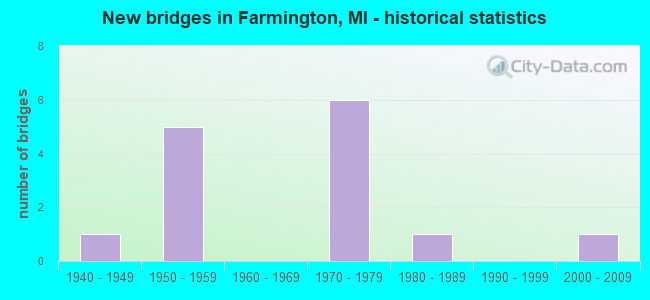
- New bridges - historical statistics
- 11940-1949
- 51950-1959
- 61970-1979
- 11980-1989
- 12000-2009
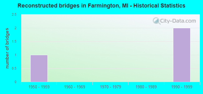
- Reconstructed bridges - Historical Statistics
- 11950-1959
- 01960-1969
- 01970-1979
- 01980-1989
- 21990-1999
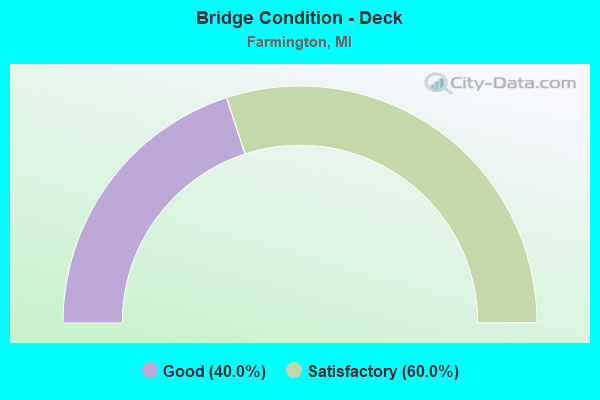
- Bridge Condition - Deck
- 40.0%Good
- 60.0%Satisfactory
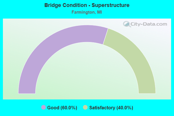
- Bridge Condition - Superstructure
- 60.0%Good
- 40.0%Satisfactory
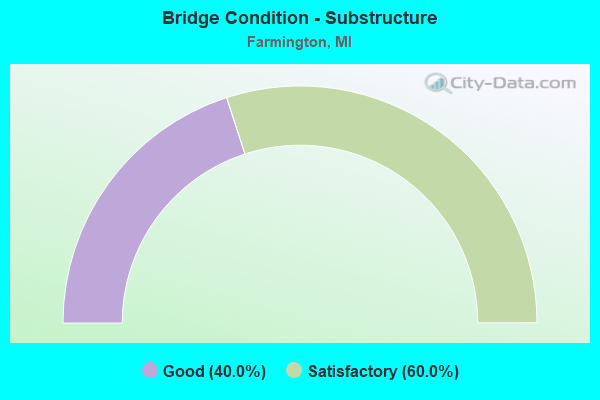
- Bridge Condition - Substructure
- 40.0%Good
- 60.0%Satisfactory

- Bridge Condition - Channel
- 33.3%Good
- 66.7%Satisfactory
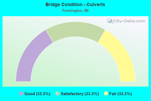
- Bridge Condition - Culverts
- 33.3%Good
- 33.3%Satisfactory
- 33.3%Fair
Find on map >> Show street view
Structure Number: 7786, Location: IN FARMINGTON (E GRAND RI (Lat: 42.459142, Lng: -83.362981), Route carried "on" structure: Business Interstate 96, Year Built: 2006, Status: Open, Structure Length: 1.04m (3.41ft), Average Daily Traffic: 16,002 (year 2007), Truck Traffic: 4%, Average Future Daily Traffic: 22,759 (year 2025), Design Load: HS 25 or greater, Features Intersected: ROUGE RIVER
Minimum Vertical Clearance: 30.48m (100.00ft), Kilometerpoint: 28.045, Lanes on structure: 5, Base Highway Network: Yes (Inventory Route: 410, Subroute: 42), Owner: State Highway Agency, Approaching Roadway Width: 16.8m (55.1ft), Material/Design: Concrete, Design/Construction: Culvert, Number Of Spans In Main Unit: 1, Length of Maximum Span: 9.8m (32.2ft), Curb-To-Curb Width: 16.8m (55.1ft), Out-to-Out Width: 21.9m (71.9ft)
Condition: Channel: Satisfactory, Culverts: Good, Operating Rating: 81.0 metric tons, Method Used To Determine Operating Rating: Assigned rating based on Load Factor Design (LFD) reported by rating factor (RF) using MS18 loading, Inventory Rating: 48.6 metric tons, Method Used To Determine Inventory Rating: Assigned rating based on Load Factor Design (LFD) reported by rating factor (RF) using MS18 loading, Structural Evaluation: Better than present minimum criteria, Deck Geometry: High priority of replacement, Waterway Adequacy: Equal to present desirable criteria, Approach Roadway Alignment: Equal to present desirable criteria, Designated Inspection Frequency: Every 24 months, Inspection Date: November 2020, Deck Structure Type: Concrete Cast-file-Place, Wearing Surface/Protective System: Wearing Surface: Integral Concrete, Deck Protection: Epoxy Coated Reinforcing
Find on map >> Show street view
Structure Number: 7807, Location: IN FARMINGTON (Lat: 42.456000, Lng: -83.375967), Route carried "on" structure: State highway 5, Year Built: 1956, Year Reconstructed: 1997, Status: Open, Structure Length: 3.96m (12.99ft), Average Daily Traffic: 16,814 (year 2007), Truck Traffic: 3%, Average Future Daily Traffic: 10,365 (year 2018), Design Load: HS 25 or greater, Features Intersected: FARMINGTON RD
Minimum Vertical Clearance: 30.48m (100.00ft), Kilometerpoint: 26.093, Lanes on structure: 2, Lanes under structure: 5, Base Highway Network: Yes (Inventory Route: 65, Subroute: 3), Owner: State Highway Agency, Approaching Roadway Width: 12.8m (42.0ft), Skew: 1 degrees, Material/Design: Steel, Design/Construction: Stringer/Multi-beam, Number Of Spans In Main Unit: 3, Length of Maximum Span: 19.8m (65.0ft), Curb-To-Curb Width: 12.8m (42.0ft), Out-to-Out Width: 14.7m (48.2ft)
Condition: Deck: Good, Superstructure: Satisfactory, Substructure: Satisfactory, Operating Rating: 59.3 metric tons, Method Used To Determine Operating Rating: Load Factor (LF) rating reported by rating factor (RF) method using MS18 loading, Inventory Rating: 35.6 metric tons, Method Used To Determine Inventory Rating: Load Factor (LF) rating reported by rating factor (RF) method using MS18 loading, Structural Evaluation: Equal to present minimum criteria, Deck Geometry: Equal to present desirable criteria, Underclear: High priority of corrective action, Approach Roadway Alignment: Equal to present desirable criteria, Designated Inspection Frequency: Every 24 months, Inspection Date: November 2020, Deck Structure Type: Concrete Cast-file-Place, Wearing Surface/Protective System: Wearing Surface: Monolithic Concrete, Deck Protection: Epoxy Coated Reinforcing
Find on map >> Show street view
Structure Number: 7808, Location: IN FARMINGTON (Lat: 42.456225, Lng: -83.375972), Route carried "on" structure: State highway 5, Year Built: 1956, Year Reconstructed: 1997, Status: Open, Structure Length: 3.96m (12.99ft), Average Daily Traffic: 16,814 (year 2007), Truck Traffic: 3%, Average Future Daily Traffic: 10,365 (year 2018), Design Load: HS 25 or greater, Features Intersected: FARMINGTON RD
Minimum Vertical Clearance: 30.48m (100.00ft), Kilometerpoint: 26.129, Lanes on structure: 2, Lanes under structure: 5, Base Highway Network: Yes (Inventory Route: 65, Subroute: 4), Owner: State Highway Agency, Approaching Roadway Width: 12.8m (42.0ft), Skew: 1 degrees, Material/Design: Steel, Design/Construction: Stringer/Multi-beam, Number Of Spans In Main Unit: 3, Length of Maximum Span: 19.8m (65.0ft), Curb-To-Curb Width: 12.8m (42.0ft), Out-to-Out Width: 14.7m (48.2ft)
Condition: Deck: Good, Superstructure: Satisfactory, Substructure: Satisfactory, Operating Rating: 59.3 metric tons, Method Used To Determine Operating Rating: Load Factor (LF) rating reported by rating factor (RF) method using MS18 loading, Inventory Rating: 35.6 metric tons, Method Used To Determine Inventory Rating: Load Factor (LF) rating reported by rating factor (RF) method using MS18 loading, Structural Evaluation: Equal to present minimum criteria, Deck Geometry: Equal to present desirable criteria, Underclear: High priority of corrective action, Approach Roadway Alignment: Equal to present desirable criteria, Designated Inspection Frequency: Every 24 months, Inspection Date: November 2020, Deck Structure Type: Concrete Cast-file-Place, Wearing Surface/Protective System: Wearing Surface: Monolithic Concrete, Deck Protection: Epoxy Coated Reinforcing
Find on map >> Show street view
Structure Number: 8123, Location: @ I-96/I-696 INTERCHANGE (Lat: 42.478114, Lng: -83.427336), Route carried "on" structure: Ramp Interstate 96, Year Built: 1971, Status: Open, Structure Length: 8.34m (27.36ft), Average Daily Traffic: 8,280 (year 1982), Truck Traffic: 13%, Average Future Daily Traffic: 9,522 (year 2002), Design Load: HS 20+Mod, Features Intersected: M-5
Minimum Vertical Clearance: 30.48m (100.00ft), Kilometerpoint: 1.577, Lanes on structure: 3, Lanes under structure: 5, Owner: State Highway Agency, Approaching Roadway Width: 15.2m (49.9ft), Material/Design: Steel, Design/Construction: Stringer/Multi-beam, Number Of Spans In Main Unit: 4, Length of Maximum Span: 35.4m (116.1ft), Curb-To-Curb Width: 15.2m (49.9ft), Out-to-Out Width: 15.9m (52.2ft)
Condition: Deck: Satisfactory, Superstructure: Good, Substructure: Satisfactory, Operating Rating: 67.7 metric tons, Method Used To Determine Operating Rating: Load Factor (LF) rating reported by rating factor (RF) method using MS18 loading, Inventory Rating: 40.8 metric tons, Method Used To Determine Inventory Rating: Load Factor (LF) rating reported by rating factor (RF) method using MS18 loading, Structural Evaluation: Equal to present minimum criteria, Deck Geometry: Superior to present desirable criteria, Underclear: Meets minimum limits, Approach Roadway Alignment: Equal to present desirable criteria, Designated Inspection Frequency: Every 24 months, Inspection Date: December 2020, Deck Structure Type: Concrete Cast-file-Place, Wearing Surface/Protective System: Wearing Surface: Epoxy Overlay
Find on map >> Show street view
Structure Number: 8128, Location: AT I-696 (Lat: 42.479986, Lng: -83.426431), Route carried "on" structure: Ramp Interstate 96, Year Built: 1972, Status: Open, Structure Length: 5.91m (19.39ft), Average Daily Traffic: 13,103 (year 2007), Truck Traffic: 3%, Average Future Daily Traffic: 9,980 (year 2018), Design Load: HS 20+Mod, Features Intersected: RAMP FROM M-102
Minimum Vertical Clearance: 30.48m (100.00ft), Kilometerpoint: 9.539, Lanes on structure: 2, Lanes under structure: 1, Owner: State Highway Agency, Approaching Roadway Width: 14.0m (45.9ft), Skew: 3 degrees, Material/Design: Steel, Design/Construction: Stringer/Multi-beam, Number Of Spans In Main Unit: 3, Length of Maximum Span: 33.5m (109.9ft), Curb-To-Curb Width: 12.3m (40.4ft), Out-to-Out Width: 13.5m (44.3ft)
Condition: Deck: Satisfactory, Superstructure: Good, Substructure: Good, Operating Rating: 92.7 metric tons, Method Used To Determine Operating Rating: Load Factor (LF) rating reported by rating factor (RF) method using MS18 loading, Inventory Rating: 55.7 metric tons, Method Used To Determine Inventory Rating: Load Factor (LF) rating reported by rating factor (RF) method using MS18 loading, Structural Evaluation: Better than present minimum criteria, Deck Geometry: Superior to present desirable criteria, Underclear: Somewhat better than minimum adequacy, Approach Roadway Alignment: Equal to present desirable criteria, Designated Inspection Frequency: Every 24 months, Inspection Date: December 2020, Deck Structure Type: Concrete Cast-file-Place, Wearing Surface/Protective System: Wearing Surface: Epoxy Overlay
Find on map >> Show street view
Structure Number: 8129, Location: I-96/I-696 INTERCHANGE (Lat: 42.478297, Lng: -83.427883), Route carried "on" structure: Interstate 96, Year Built: 1972, Status: Open, Structure Length: 8.23m (27.00ft), Average Daily Traffic: 76,500 (year 1995), Truck Traffic: 7%, Average Future Daily Traffic: 81,786 (year 2015), Design Load: HS 20, Features Intersected: M-5
Minimum Vertical Clearance: 30.48m (100.00ft), Kilometerpoint: 0.204, Lanes on structure: 2, Lanes under structure: 6, Base Highway Network: Yes (Inventory Route: 441, Subroute: 20), Owner: State Highway Agency, Approaching Roadway Width: 13.7m (44.9ft), Skew: 1 degrees, Material/Design: Steel, Design/Construction: Stringer/Multi-beam, Number Of Spans In Main Unit: 4, Length of Maximum Span: 33.0m (108.3ft), Curb-To-Curb Width: 12.3m (40.4ft), Out-to-Out Width: 13.5m (44.3ft)
Condition: Deck: Satisfactory, Superstructure: Good, Substructure: Good, Operating Rating: 65.4 metric tons, Method Used To Determine Operating Rating: Load Factor (LF) rating reported by rating factor (RF) method using MS18 loading, Inventory Rating: 39.2 metric tons, Method Used To Determine Inventory Rating: Load Factor (LF) rating reported by rating factor (RF) method using MS18 loading, Structural Evaluation: Better than present minimum criteria, Deck Geometry: Somewhat better than minimum adequacy, Underclear: Equal to present minimum criteria, Approach Roadway Alignment: Equal to present desirable criteria, Designated Inspection Frequency: Every 24 months, Inspection Date: December 2020, Deck Structure Type: Concrete Cast-file-Place, Wearing Surface/Protective System: Wearing Surface: Epoxy Overlay
Find on map >> Show street view
Structure Number: 8236, Location: 50FT W OF FARMINGTON ROAD (Lat: 42.466142, Lng: -83.371781), Route carried "on" structure: City street , Year Built: 1981, Status: Open, Structure Length: 0.91m (2.99ft), Average Daily Traffic: 4,290 (year 2008), Truck Traffic: 5%, Average Future Daily Traffic: 4,500 (year 2028), Features Intersected: BRANCH UPPER ROUGE RIVER, Facility Carried by Structure: SHIAWASSEE STREET
Minimum Vertical Clearance: 30.48m (100.00ft), Kilometerpoint: 1.033, Lanes on structure: 3, Owner: City or Municipal Highway Agency, Approaching Roadway Width: 15.2m (49.9ft), Material/Design: Steel, Design/Construction: Culvert, Number Of Spans In Main Unit: 1, Length of Maximum Span: 9.1m (29.9ft), Curb or Sidewalk Widths: Left: 2.4m (7.9ft), Right: 0.0m, Curb-To-Curb Width: 17.7m (58.1ft), Out-to-Out Width: 20.3m (66.6ft)
Condition: Channel: Good, Culverts: Fair, Operating Rating: 33.4 metric tons, Method Used To Determine Operating Rating: Load Factor (LF) rating reported by rating factor (RF) method using MS18 loading, Inventory Rating: 20.1 metric tons, Method Used To Determine Inventory Rating: Load Factor (LF) rating reported by rating factor (RF) method using MS18 loading, Structural Evaluation: Somewhat better than minimum adequacy, Deck Geometry: Superior to present desirable criteria, Waterway Adequacy: Somewhat better than minimum adequacy, Approach Roadway Alignment: Equal to present desirable criteria, Designated Inspection Frequency: Every 24 months, Inspection Date: April 2020, Wearing Surface/Protective System: Wearing Surface: Monolithic Concrete
Find on map >> Show street view
Structure Number: 8237, Location: 0.1 MI N OF GRAND RIVER (Lat: 42.461733, Lng: -83.366561), Route carried "on" structure: City street , Year Built: 1940, Year Reconstructed: 1957, Status: Open, Structure Length: 0.88m (2.89ft), Average Daily Traffic: 2,580 (year 2008), Truck Traffic: 2%, Average Future Daily Traffic: 1,700 (year 2028), Features Intersected: UPPER ROUGE RIVER, Facility Carried by Structure: POWER ROAD
Minimum Vertical Clearance: 30.48m (100.00ft), Kilometerpoint: 0.708, Lanes on structure: 2, Owner: City or Municipal Highway Agency, Approaching Roadway Width: 9.1m (29.9ft), Skew: 1 degrees, Material/Design: Concrete, Design/Construction: Culvert, Number Of Spans In Main Unit: 1, Length of Maximum Span: 7.3m (24.0ft), Curb or Sidewalk Widths: Left: 0.0m, Right: 1.9m (6.2ft), Curb-To-Curb Width: 11.6m (38.1ft), Out-to-Out Width: 13.5m (44.3ft)
Condition: Channel: Satisfactory, Culverts: Satisfactory, Operating Rating: 66.4 metric tons, Method Used To Determine Operating Rating: Load Factor (LF) rating reported by rating factor (RF) method using MS18 loading, Inventory Rating: 39.9 metric tons, Method Used To Determine Inventory Rating: Load Factor (LF) rating reported by rating factor (RF) method using MS18 loading, Structural Evaluation: Equal to present minimum criteria, Deck Geometry: Somewhat better than minimum adequacy, Waterway Adequacy: Meets minimum limits, Approach Roadway Alignment: Equal to present desirable criteria, Designated Inspection Frequency: Every 24 months, Inspection Date: April 2020, Wearing Surface/Protective System: Wearing Surface: Bituminous
Find on map >> Show street view
Structure Number: 7791, Location: IN FARMINGTON (Lat: 42.454564, Lng: -83.365894), Route carried "under" structure: State highway 5, Year Built: 1959, Structure Length: 0. m, Average Daily Traffic: 33,628 (year 2007), Truck Traffic: 3%, Features Intersected: M-5, Facility Carried by Structure: POWERS RD WALKOVER
Minimum Vertical Clearance: 4.57m (14.99ft), Kilometerpoint: 26.937, Lanes under structure: 4, Material/Design: Steel, Design/Construction: Girder and Floorbeam System, Length of Maximum Span: 19.8m (65.0ft)
Find on map >> Show street view
Structure Number: 7807, Location: IN FARMINGTON (Lat: 42.456000, Lng: -83.375967), Route carried "under" structure: County highway 2059, Year Built: 1956, Structure Length: 0. m, Average Daily Traffic: 500 (year 1974), Features Intersected: FARMINGTON RD, Facility Carried by Structure: M-5 EB
Minimum Vertical Clearance: 4.80m (15.75ft), Kilometerpoint: 1.716, Lanes on structure: 2, Lanes under structure: 5, Material/Design: Steel, Design/Construction: Stringer/Multi-beam, Length of Maximum Span: 19.8m (65.0ft)
Find on map >> Show street view
Structure Number: 7808, Location: IN FARMINGTON (Lat: 42.456225, Lng: -83.375972), Route carried "under" structure: County highway 2059, Year Built: 1956, Structure Length: 0. m, Average Daily Traffic: 500 (year 1974), Features Intersected: FARMINGTON RD, Facility Carried by Structure: M-5 WB
Minimum Vertical Clearance: 4.78m (15.68ft), Kilometerpoint: 1.741, Lanes on structure: 2, Lanes under structure: 5, Material/Design: Steel, Design/Construction: Stringer/Multi-beam, Length of Maximum Span: 19.8m (65.0ft)
Find on map >> Show street view
Structure Number: 8123, Location: @ I-96/I-696 INTERCHANGE (Lat: 42.478114, Lng: -83.427336), Route carried "under" structure: State highway 5, Year Built: 1971, Structure Length: 0. m, Average Daily Traffic: 32,868 (year 2007), Truck Traffic: 2%, Features Intersected: M-5, Facility Carried by Structure: I-96 RAMP
Minimum Vertical Clearance: 5.03m (16.50ft), Kilometerpoint: 20.834, Lanes on structure: 3, Lanes under structure: 5, Material/Design: Steel, Design/Construction: Stringer/Multi-beam, Length of Maximum Span: 35.4m (116.1ft)
Find on map >> Show street view
Structure Number: 8128, Location: AT I-696 (Lat: 42.479986, Lng: -83.426431), Route carried "under" structure: Ramp State highway 102, Year Built: 1972, Structure Length: 0. m, Average Daily Traffic: 2,500 (year 0000), Features Intersected: RAMP FROM M-102, Facility Carried by Structure: I-96 RAMP
Minimum Vertical Clearance: 5.03m (16.50ft), Kilometerpoint: 1.827, Lanes on structure: 2, Lanes under structure: 1, Material/Design: Steel, Design/Construction: Stringer/Multi-beam, Length of Maximum Span: 33.5m (109.9ft)
Find on map >> Show street view
Structure Number: 8129, Location: I-96/I-696 INTERCHANGE (Lat: 42.478297, Lng: -83.427883), Route carried "under" structure: State highway 5, Year Built: 1972, Structure Length: 0. m, Average Daily Traffic: 32,868 (year 2007), Truck Traffic: 2%, Features Intersected: M-5, Facility Carried by Structure: I-96
Minimum Vertical Clearance: 5.28m (17.32ft), Kilometerpoint: 20.790, Lanes on structure: 2, Lanes under structure: 6, Material/Design: Steel, Design/Construction: Stringer/Multi-beam, Length of Maximum Span: 33.0m (108.3ft)