Bridge Statistics for Fayette, Iowa (IA)
Condition, Traffic, Stress, Structural Evaluation, Project Costs
- National Bridge Inventory (NBI) Statistics
- 18Number of bridges
- 190ft / 58.4mTotal length
- 11,310Total average daily traffic
- 1,549Total average daily truck traffic
- 11,310Total future (year 2040) average daily traffic
- National Bridge Inventory (NBI) Registered Bridges for Fayette
- No street view available for this location
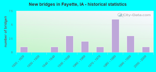
- New bridges - historical statistics
- 11920-1929
- 11940-1949
- 31950-1959
- 21960-1969
- 11970-1979
- 61980-1989
- 31990-1999
- 12000-2009
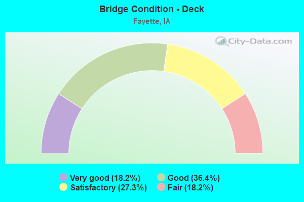
- Bridge Condition - Deck
- 18.2%Very good
- 36.4%Good
- 27.3%Satisfactory
- 18.2%Fair
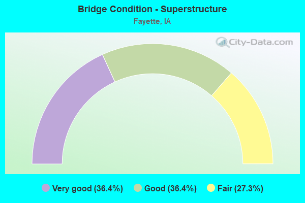
- Bridge Condition - Superstructure
- 36.4%Very good
- 36.4%Good
- 27.3%Fair
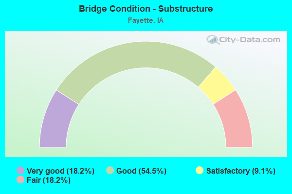
- Bridge Condition - Substructure
- 18.2%Very good
- 54.5%Good
- 9.1%Satisfactory
- 18.2%Fair
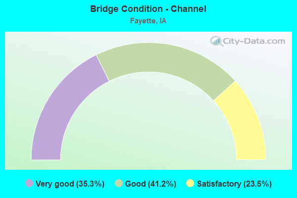
- Bridge Condition - Channel
- 35.3%Very good
- 41.2%Good
- 23.5%Satisfactory
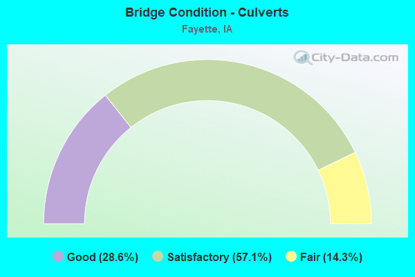
- Bridge Condition - Culverts
- 28.6%Good
- 57.1%Satisfactory
- 14.3%Fair
Find on map >> Show street view
Structure Number: 4801, Location: 000000000 (Lat: 42.851886, Lng: -91.807447), Route carried "on" structure: City street , Year Built: 1998, Status: Open, Structure Length: 0.88m (2.89ft), Average Daily Traffic: 600 (year 2021), Average Future Daily Traffic: 600 (year 2041), Features Intersected: DRAINAGE, Facility Carried by Structure: N MAIN ST
Minimum Vertical Clearance: 30+ m (98+ ft), Kilometerpoint: 0.690, Lanes on structure: 2, Owner: City or Municipal Highway Agency, Maintenance Responsibility: County Highway Agency, Approaching Roadway Width: 10.7m (35.1ft), Skew: 4 degrees, Material/Design: Concrete continuous, Design/Construction: Culvert, Number Of Spans In Main Unit: 2, Length of Maximum Span: 3.0m (9.8ft)
Condition: Channel: Good, Culverts: Satisfactory, Operating Rating: 35.0 metric tons, Method Used To Determine Operating Rating: Load and Resistance Factor Rating (LRFR) rating reported by rating factor(RF) method using HL-93 loadings, Inventory Rating: 26.9 metric tons, Method Used To Determine Inventory Rating: Load and Resistance Factor Rating (LRFR) rating reported by rating factor(RF) method using HL-93 loadings, Structural Evaluation: Equal to present minimum criteria, Waterway Adequacy: Superior to present desirable criteria, Approach Roadway Alignment: Equal to present minimum criteria, Designated Inspection Frequency: Every 24 months, Inspection Date: October 2021
Find on map >> Show street view
Structure Number: 4821, Location: 000000000 (Lat: 42.847128, Lng: -91.802528), Route carried "on" structure: City street , Year Built: 1988, Status: Open, Structure Length: 0.67m (2.20ft), Average Daily Traffic: 200 (year 2021), Average Future Daily Traffic: 200 (year 2041), Design Load: HS 20, Features Intersected: UNNAMED CREEK, Facility Carried by Structure: JADE ROAD
Minimum Vertical Clearance: 30+ m (98+ ft), Kilometerpoint: 0.043, Lanes on structure: 2, Owner: City or Municipal Highway Agency, Maintenance Responsibility: County Highway Agency, Approaching Roadway Width: 12.2m (40.0ft), Material/Design: Concrete continuous, Design/Construction: Culvert, Number Of Spans In Main Unit: 2, Length of Maximum Span: 3.0m (9.8ft)
Condition: Channel: Good, Culverts: Good, Operating Rating: 44.1 metric tons, Method Used To Determine Operating Rating: No rating analysis performed, Inventory Rating: 32.3 metric tons, Method Used To Determine Inventory Rating: No rating analysis performed, Structural Evaluation: Better than present minimum criteria, Waterway Adequacy: Equal to present desirable criteria, Approach Roadway Alignment: Equal to present desirable criteria, Designated Inspection Frequency: Every 24 months, Inspection Date: October 2021
Find on map >> Show street view
Structure Number: 24631, Location: 1.4 Mi. W OF JCT. IA 150 (Lat: 42.845569, Lng: -91.836028), Route carried "on" structure: State highway 93, Year Built: 1989, Status: Open, Structure Length: 4.36m (14.30ft), Average Daily Traffic: 820 (year 2020), Truck Traffic: 12%, Average Future Daily Traffic: 820 (year 2041), Design Load: HS 20, Features Intersected: COULEE CREEK
Minimum Vertical Clearance: 30+ m (98+ ft), Kilometerpoint: 45.297, Lanes on structure: 2, Base Highway Network: Yes, Owner: State Highway Agency, Approaching Roadway Width: 12.2m (40.0ft), Material/Design: Prestressed concrete, Design/Construction: Stringer/Multi-beam, Number Of Spans In Main Unit: 3, Length of Maximum Span: 17.4m (57.1ft), Curb-To-Curb Width: 11.0m (36.1ft), Out-to-Out Width: 11.9m (39.0ft)
Condition: Deck: Satisfactory, Superstructure: Very good, Substructure: Good, Channel: Very good, Operating Rating: 78.0 metric tons, Method Used To Determine Operating Rating: Load Factor (LF), Inventory Rating: 46.6 metric tons, Method Used To Determine Inventory Rating: Load Factor (LF), Structural Evaluation: Better than present minimum criteria, Deck Geometry: Better than present minimum criteria, Waterway Adequacy: Equal to present minimum criteria, Approach Roadway Alignment: Equal to present minimum criteria, Designated Inspection Frequency: Every 24 months, Inspection Date: March 2021, Deck Structure Type: Concrete Cast-file-Place, Wearing Surface/Protective System: Wearing Surface: Monolithic Concrete, Deck Protection: Epoxy Coated Reinforcing
Find on map >> Show street view
Structure Number: 24641, Location: 0.4 mi. W of Jct. IA #150 (Lat: 42.844261, Lng: -91.818631), Route carried "on" structure: State highway 93, Year Built: 1989, Status: Open, Structure Length: 8.84m (29.00ft), Average Daily Traffic: 820 (year 2020), Truck Traffic: 12%, Average Future Daily Traffic: 820 (year 2040), Design Load: HS 20, Features Intersected: VOLGA RIVER
Minimum Vertical Clearance: 30+ m (98+ ft), Kilometerpoint: 46.777, Lanes on structure: 2, Base Highway Network: Yes, Owner: State Highway Agency, Approaching Roadway Width: 11.0m (36.1ft), Skew: 4 degrees, Material/Design: Prestressed concrete, Design/Construction: Stringer/Multi-beam, Number Of Spans In Main Unit: 3, Length of Maximum Span: 29.6m (97.1ft), Curb-To-Curb Width: 11.0m (36.1ft), Out-to-Out Width: 11.9m (39.0ft)
Condition: Deck: Satisfactory, Superstructure: Good, Substructure: Good, Channel: Very good, Operating Rating: 89.4 metric tons, Method Used To Determine Operating Rating: Load Factor (LF), Inventory Rating: 41.9 metric tons, Method Used To Determine Inventory Rating: Load Factor (LF), Structural Evaluation: Better than present minimum criteria, Deck Geometry: Better than present minimum criteria, Waterway Adequacy: Equal to present minimum criteria, Approach Roadway Alignment: Better than present minimum criteria, Designated Inspection Frequency: Every 22 months, Underwater Inspection Frequency: Every 60 months, Inspection Date: June 2020, Underwater Inspection Date: April 2018, Deck Structure Type: Concrete Cast-file-Place, Wearing Surface/Protective System: Wearing Surface: Monolithic Concrete, Deck Protection: Epoxy Coated Reinforcing
Find on map >> Show street view
Structure Number: 24651, Location: 0.2 Mi. W OF JCT. IA #150 (Lat: 42.844344, Lng: -91.815547), Route carried "on" structure: State highway 93, Year Built: 1989, Status: Open, Structure Length: 3.81m (12.50ft), Average Daily Traffic: 820 (year 2020), Truck Traffic: 12%, Average Future Daily Traffic: 820 (year 2040), Design Load: HS 20, Features Intersected: VOLGA RIVER OVERFLOW
Minimum Vertical Clearance: 30+ m (98+ ft), Kilometerpoint: 47.030, Lanes on structure: 2, Base Highway Network: Yes, Owner: State Highway Agency, Approaching Roadway Width: 12.8m (42.0ft), Material/Design: Concrete continuous, Design/Construction: Slab, Number Of Spans In Main Unit: 3, Length of Maximum Span: 14.9m (48.9ft), Curb-To-Curb Width: 11.0m (36.1ft), Out-to-Out Width: 11.9m (39.0ft)
Condition: Deck: Good, Superstructure: Good, Substructure: Good, Channel: Good, Operating Rating: 89.4 metric tons, Method Used To Determine Operating Rating: Load Factor (LF), Inventory Rating: 53.7 metric tons, Method Used To Determine Inventory Rating: Load Factor (LF), Structural Evaluation: Better than present minimum criteria, Deck Geometry: Better than present minimum criteria, Waterway Adequacy: Better than present minimum criteria, Approach Roadway Alignment: Better than present minimum criteria, Designated Inspection Frequency: Every 24 months, Inspection Date: April 2020, Deck Structure Type: Concrete Cast-file-Place, Wearing Surface/Protective System: Wearing Surface: Monolithic Concrete, Deck Protection: Epoxy Coated Reinforcing
Find on map >> Show street view
Structure Number: 2474, Location: 1.1 MI. N OF JCT. IA 187 (Lat: 42.789972, Lng: -91.804886), Route carried "on" structure: State highway 150, Year Built: 1959, Year Reconstructed: 1969, Status: Open, Structure Length: 0.98m (3.22ft), Average Daily Traffic: 2,390 (year 2020), Truck Traffic: 17%, Average Future Daily Traffic: 2,390 (year 2040), Design Load: HS 20, Features Intersected: ALEXANDER CREEK
Minimum Vertical Clearance: 30+ m (98+ ft), Kilometerpoint: 90.918, Lanes on structure: 2, Base Highway Network: Yes, Owner: State Highway Agency, Approaching Roadway Width: 15.2m (49.9ft), Skew: 3 degrees, Material/Design: Concrete continuous, Design/Construction: Culvert, Number Of Spans In Main Unit: 3, Length of Maximum Span: 3.0m (9.8ft)
Condition: Channel: Satisfactory, Culverts: Satisfactory, Operating Rating: 44.0 metric tons, Method Used To Determine Operating Rating: Assigned rating based on Load Factor Design (LFD) reported in metric tons, Inventory Rating: 22.7 metric tons, Method Used To Determine Inventory Rating: Assigned rating based on Load Factor Design (LFD) reported in metric tons, Structural Evaluation: Equal to present minimum criteria, Waterway Adequacy: Equal to present desirable criteria, Approach Roadway Alignment: Equal to present desirable criteria, Designated Inspection Frequency: Every 24 months, Inspection Date: April 2020
Find on map >> Show street view
Structure Number: 2475, Location: 0.5 mi. S of Jct. IA #93 (Lat: 42.836906, Lng: -91.809128), Route carried "on" structure: State highway 150, Year Built: 1961, Status: Open, Structure Length: 2.01m (6.59ft), Average Daily Traffic: 2,550 (year 2020), Truck Traffic: 16%, Average Future Daily Traffic: 2,550 (year 2040), Design Load: HS 20, Features Intersected: ABAND RR
Minimum Vertical Clearance: 30+ m (98+ ft), Kilometerpoint: 96.187, Lanes on structure: 2, Base Highway Network: Yes, Owner: State Highway Agency, Approaching Roadway Width: 13.4m (44.0ft), Material/Design: Prestressed concrete, Design/Construction: Stringer/Multi-beam, Number Of Spans In Main Unit: 1, Length of Maximum Span: 19.2m (63.0ft), Curb-To-Curb Width: 13.5m (44.3ft), Out-to-Out Width: 15.2m (49.9ft)
Condition: Deck: Good, Superstructure: Very good, Substructure: Good, Operating Rating: 65.1 metric tons, Method Used To Determine Operating Rating: Load Factor (LF), Inventory Rating: 39.2 metric tons, Method Used To Determine Inventory Rating: Load Factor (LF), Structural Evaluation: Better than present minimum criteria, Deck Geometry: Superior to present desirable criteria, Approach Roadway Alignment: Better than present minimum criteria, Designated Inspection Frequency: Every 24 months, Inspection Date: April 2020, Deck Structure Type: Concrete Cast-file-Place, Wearing Surface/Protective System: Wearing Surface: Low Slump Concrete
Find on map >> Show street view
Structure Number: 2476, Location: 0.2 MI. N OF JCT. 93 (Lat: 42.846017, Lng: -91.810228), Route carried "on" structure: State highway 150, Year Built: 1961, Status: Open, Structure Length: 10.76m (35.30ft), Average Daily Traffic: 2,760 (year 2020), Truck Traffic: 16%, Average Future Daily Traffic: 2,760 (year 2040), Design Load: HS 20, Features Intersected: VOLGA RIVER
Minimum Vertical Clearance: 30+ m (98+ ft), Kilometerpoint: 97.217, Lanes on structure: 2, Base Highway Network: Yes, Owner: State Highway Agency, Approaching Roadway Width: 13.4m (44.0ft), Material/Design: Steel continuous, Design/Construction: Stringer/Multi-beam, Number Of Spans In Main Unit: 3, Length of Maximum Span: 41.8m (137.1ft), Curb-To-Curb Width: 9.1m (29.9ft), Out-to-Out Width: 11.0m (36.1ft)
Condition: Deck: Fair, Superstructure: Fair, Substructure: Satisfactory, Channel: Good, Operating Rating: 53.2 metric tons, Method Used To Determine Operating Rating: Load Factor (LF), Inventory Rating: 31.9 metric tons, Method Used To Determine Inventory Rating: Load Factor (LF), Structural Evaluation: Somewhat better than minimum adequacy, Deck Geometry: Meets minimum limits, Waterway Adequacy: Equal to present minimum criteria, Approach Roadway Alignment: Equal to present minimum criteria, Designated Inspection Frequency: Every 24 months, Inspection Date: August 2020, Deck Structure Type: Concrete Cast-file-Place, Wearing Surface/Protective System: Wearing Surface: Low Slump Concrete
Find on map >> Show street view
Structure Number: 15021, Location: 092080601 (Lat: 42.818042, Lng: -91.831578), Route carried "on" structure: County highway , Year Built: 1950, Status: Open, Structure Length: 0.79m (2.59ft), Average Daily Traffic: 40 (year 2021), Average Future Daily Traffic: 40 (year 2041), Features Intersected: STREAM, Facility Carried by Structure: 130TH ST.
Minimum Vertical Clearance: 30+ m (98+ ft), Kilometerpoint: 20.387, Lanes on structure: 2, Owner: County Highway Agency, Approaching Roadway Width: 7.9m (25.9ft), Skew: 3 degrees, Material/Design: Concrete, Design/Construction: Culvert, Number Of Spans In Main Unit: 2, Length of Maximum Span: 4.6m (15.1ft)
Condition: Channel: Good, Culverts: Satisfactory, Operating Rating: 44.1 metric tons, Method Used To Determine Operating Rating: Field evaluation and documented engineering judgment, Inventory Rating: 32.7 metric tons, Method Used To Determine Inventory Rating: Field evaluation and documented engineering judgment, Structural Evaluation: Equal to present minimum criteria, Waterway Adequacy: Better than present minimum criteria, Approach Roadway Alignment: Equal to present desirable criteria, Length Of Structure Improvement: 2.30m (7.55ft), Designated Inspection Frequency: Every 24 months, Inspection Date: October 2021, Bridge Improvement Cost: $65,000, Roadway Improvement Cost: $10,000
Find on map >> Show street view
Structure Number: 150221, Location: 092080801 (Lat: 42.803344, Lng: -91.808000), Route carried "on" structure: County highway , Year Built: 1989, Status: Open, Structure Length: 0.73m (2.40ft), Average Daily Traffic: 35 (year 2017), Average Future Daily Traffic: 35 (year 2041), Design Load: HS 20, Features Intersected: ALEXANDER CR, Facility Carried by Structure: 120TH ST.
Minimum Vertical Clearance: 30+ m (98+ ft), Kilometerpoint: 19.652, Lanes on structure: 2, Owner: County Highway Agency, Approaching Roadway Width: 6.1m (20.0ft), Material/Design: Steel, Design/Construction: Culvert, Number Of Spans In Main Unit: 2, Length of Maximum Span: 3.0m (9.8ft)
Condition: Channel: Satisfactory, Culverts: Fair, Operating Rating: 44.1 metric tons, Method Used To Determine Operating Rating: Field evaluation and documented engineering judgment, Inventory Rating: 32.7 metric tons, Method Used To Determine Inventory Rating: Field evaluation and documented engineering judgment, Structural Evaluation: Somewhat better than minimum adequacy, Waterway Adequacy: Equal to present desirable criteria, Approach Roadway Alignment: Equal to present desirable criteria, Designated Inspection Frequency: Every 24 months, Inspection Date: October 2021
Find on map >> Show street view
Structure Number: 151191, Location: 093081306 (Lat: 42.863992, Lng: -91.741228), Route carried "on" structure: County highway , Year Built: 1979, Status: Open, Structure Length: 6.61m (21.69ft), Average Daily Traffic: 35 (year 2021), Average Future Daily Traffic: 35 (year 2041), Design Load: H 20, Features Intersected: VOLGA RIVER, Facility Carried by Structure: HERON RD.
Minimum Vertical Clearance: 30+ m (98+ ft), Kilometerpoint: 3.895, Lanes on structure: 2, Owner: County Highway Agency, Approaching Roadway Width: 11.0m (36.1ft), Material/Design: Prestressed concrete continuous, Design/Construction: Stringer/Multi-beam, Number Of Spans In Main Unit: 3, Length of Maximum Span: 23.5m (77.1ft), Curb-To-Curb Width: 9.1m (29.9ft), Out-to-Out Width: 10.2m (33.5ft)
Condition: Deck: Very good, Superstructure: Very good, Substructure: Very good, Channel: Very good, Operating Rating: 73.9 metric tons, Method Used To Determine Operating Rating: Allowable Stress (AS), Inventory Rating: 32.5 metric tons, Method Used To Determine Inventory Rating: Allowable Stress (AS), Structural Evaluation: Equal to present desirable criteria, Deck Geometry: Better than present minimum criteria, Waterway Adequacy: Superior to present desirable criteria, Approach Roadway Alignment: Equal to present desirable criteria, Designated Inspection Frequency: Every 24 months, Inspection Date: October 2021, Deck Structure Type: Concrete Cast-file-Place, Wearing Surface/Protective System: Wearing Surface: Monolithic Concrete
Find on map >> Show street view
Structure Number: 15125, Location: 093081804 (Lat: 42.861050, Lng: -91.845008), Route carried "on" structure: County highway , Year Built: 1949, Status: Open, Structure Length: 2.65m (8.69ft), Average Daily Traffic: 100 (year 2017), Average Future Daily Traffic: 100 (year 2041), Features Intersected: COULEE CREEK, Facility Carried by Structure: M AVE.
Minimum Vertical Clearance: 30+ m (98+ ft), Kilometerpoint: 16.090, Lanes on structure: 1, Owner: County Highway Agency, Approaching Roadway Width: 7.3m (24.0ft), Skew: 3 degrees, Material/Design: Steel, Design/Construction: Stringer/Multi-beam, Number Of Spans In Main Unit: 2, Length of Maximum Span: 12.5m (41.0ft), Curb or Sidewalk Widths: Left: 0.3m (1.0ft), Right: 0.3m (1.0ft), Curb-To-Curb Width: 5.4m (17.7ft), Out-to-Out Width: 5.9m (19.4ft)
Condition: Deck: Good, Superstructure: Good, Substructure: Good, Channel: Very good, Operating Rating: 41.1 metric tons, Method Used To Determine Operating Rating: Load Factor (LF), Inventory Rating: 24.6 metric tons, Method Used To Determine Inventory Rating: Load Factor (LF), Structural Evaluation: Equal to present minimum criteria, Deck Geometry: High priority of corrective action, Waterway Adequacy: Better than present minimum criteria, Approach Roadway Alignment: Equal to present desirable criteria, Length Of Structure Improvement: 12.50m (41.01ft), Designated Inspection Frequency: Every 24 months, Inspection Date: October 2021, Bridge Improvement Cost: $138,000, Roadway Improvement Cost: $37,000, Deck Structure Type: Concrete Cast-file-Place, Wearing Surface/Protective System: Wearing Surface: Monolithic Concrete
Find on map >> Show street view
Structure Number: 15126, Location: 093081903 (Lat: 42.851200, Lng: -91.840372), Route carried "on" structure: County highway , Year Built: 1924, Status: Open, Structure Length: 1.30m (4.27ft), Average Daily Traffic: 45 (year 2017), Average Future Daily Traffic: 45 (year 2041), Features Intersected: THE COULEE, Facility Carried by Structure: 152TH ST.
Minimum Vertical Clearance: 30+ m (98+ ft), Kilometerpoint: 0.383, Lanes on structure: 2, Owner: County Highway Agency, Approaching Roadway Width: 6.7m (22.0ft), Skew: 3 degrees, Material/Design: Concrete, Design/Construction: Tee Beam, Number Of Spans In Main Unit: 1, Length of Maximum Span: 12.2m (40.0ft), Curb or Sidewalk Widths: Left: 0.3m (1.0ft), Right: 0.3m (1.0ft), Curb-To-Curb Width: 6.1m (20.0ft), Out-to-Out Width: 7.5m (24.6ft)
Condition: Deck: Satisfactory, Superstructure: Fair, Substructure: Fair, Channel: Satisfactory, Operating Rating: 44.1 metric tons, Method Used To Determine Operating Rating: Field evaluation and documented engineering judgment, Inventory Rating: 32.7 metric tons, Method Used To Determine Inventory Rating: Field evaluation and documented engineering judgment, Structural Evaluation: Somewhat better than minimum adequacy, Deck Geometry: Somewhat better than minimum adequacy, Waterway Adequacy: Somewhat better than minimum adequacy, Approach Roadway Alignment: Equal to present desirable criteria, Length Of Structure Improvement: 12.50m (41.01ft), Designated Inspection Frequency: Every 24 months, Inspection Date: October 2021, Bridge Improvement Cost: $135,000, Roadway Improvement Cost: $35,000, Deck Structure Type: Concrete Cast-file-Place, Wearing Surface/Protective System: Wearing Surface: Monolithic Concrete
Find on map >> Show street view
Structure Number: 151271, Location: 093082406 (Lat: 42.853175, Lng: -91.728681), Route carried "on" structure: County highway , Year Built: 1998, Status: Open, Structure Length: 0.94m (3.08ft), Average Daily Traffic: 20 (year 2017), Average Future Daily Traffic: 20 (year 2041), Design Load: HS 20, Features Intersected: UNAMED CR, Facility Carried by Structure: GRAIN RD.
Minimum Vertical Clearance: 30+ m (98+ ft), Kilometerpoint: 3.579, Lanes on structure: 2, Owner: County Highway Agency, Approaching Roadway Width: 7.9m (25.9ft), Material/Design: Steel, Design/Construction: Culvert, Number Of Spans In Main Unit: 3, Length of Maximum Span: 2.4m (7.9ft)
Condition: Channel: Good, Culverts: Satisfactory, Operating Rating: 44.1 metric tons, Method Used To Determine Operating Rating: Field evaluation and documented engineering judgment, Inventory Rating: 32.3 metric tons, Method Used To Determine Inventory Rating: Field evaluation and documented engineering judgment, Structural Evaluation: Equal to present minimum criteria, Waterway Adequacy: Better than present minimum criteria, Approach Roadway Alignment: Equal to present desirable criteria, Designated Inspection Frequency: Every 24 months, Inspection Date: October 2021
Find on map >> Show street view
Structure Number: 151291, Location: 093083002 (Lat: 42.833894, Lng: -91.845242), Route carried "on" structure: County highway , Year Built: 1992, Status: Open, Structure Length: 5.36m (17.59ft), Average Daily Traffic: 45 (year 2017), Average Future Daily Traffic: 45 (year 2041), Design Load: HS 20, Features Intersected: VOLGA RIVER, Facility Carried by Structure: M AVE.
Minimum Vertical Clearance: 30+ m (98+ ft), Kilometerpoint: 13.074, Lanes on structure: 2, Owner: County Highway Agency, Approaching Roadway Width: 7.9m (25.9ft), Material/Design: Prestressed concrete continuous, Design/Construction: Stringer/Multi-beam, Number Of Spans In Main Unit: 3, Length of Maximum Span: 19.8m (65.0ft), Curb-To-Curb Width: 7.5m (24.6ft), Out-to-Out Width: 8.3m (27.2ft)
Condition: Deck: Very good, Superstructure: Very good, Substructure: Very good, Channel: Very good, Operating Rating: 76.3 metric tons, Method Used To Determine Operating Rating: Allowable Stress (AS), Inventory Rating: 38.7 metric tons, Method Used To Determine Inventory Rating: Allowable Stress (AS), Structural Evaluation: Equal to present desirable criteria, Deck Geometry: Equal to present minimum criteria, Waterway Adequacy: Equal to present desirable criteria, Approach Roadway Alignment: Equal to present desirable criteria, Designated Inspection Frequency: Every 24 months, Inspection Date: October 2021, Deck Structure Type: Concrete Cast-file-Place, Wearing Surface/Protective System: Wearing Surface: Monolithic Concrete
Find on map >> Show street view
Structure Number: 151321, Location: 093083605 (Lat: 42.822731, Lng: -91.733069), Route carried "on" structure: County highway , Year Built: 2001, Status: Open, Structure Length: 1.22m (4.00ft), Average Daily Traffic: 30 (year 2017), Average Future Daily Traffic: 30 (year 2041), Design Load: HS 20, Features Intersected: GRANNIS CR, Facility Carried by Structure: GRANNIS RD
Minimum Vertical Clearance: 30+ m (98+ ft), Kilometerpoint: 2.515, Lanes on structure: 2, Owner: County Highway Agency, Approaching Roadway Width: 7.9m (25.9ft), Skew: 3 degrees, Material/Design: Steel, Design/Construction: Culvert, Number Of Spans In Main Unit: 3, Length of Maximum Span: 2.4m (7.9ft)
Condition: Channel: Very good, Culverts: Good, Operating Rating: 44.4 metric tons, Method Used To Determine Operating Rating: Field evaluation and documented engineering judgment, Inventory Rating: 32.7 metric tons, Method Used To Determine Inventory Rating: Field evaluation and documented engineering judgment, Structural Evaluation: Better than present minimum criteria, Waterway Adequacy: Equal to present desirable criteria, Approach Roadway Alignment: Equal to present desirable criteria, Designated Inspection Frequency: Every 24 months, Inspection Date: October 2021
Find on map >> Show street view
Structure Number: 6997, Location: IN VOLGA RIVER ST.PARK (Lat: 42.880278, Lng: -91.765672), Route carried "on" structure: State lands road , Year Built: 1957, Status: Open, Structure Length: 2.35m (7.71ft), Design Load: H 20, Features Intersected: FROG HOLLOW CREEK, Facility Carried by Structure: PK 678(VOLGA R)
Minimum Vertical Clearance: 30+ m (98+ ft), Kilometerpoint: 0.150, Lanes on structure: 2, Owner: State Park, Forest, or Reservation Agency, Approaching Roadway Width: 7.9m (25.9ft), Material/Design: Concrete continuous, Design/Construction: Slab, Number Of Spans In Main Unit: 3, Length of Maximum Span: 8.8m (28.9ft), Curb or Sidewalk Widths: Left: 0.3m (1.0ft), Right: 0.3m (1.0ft), Curb-To-Curb Width: 6.1m (20.0ft), Out-to-Out Width: 7.0m (23.0ft)
Condition: Deck: Fair, Superstructure: Fair, Substructure: Fair, Channel: Satisfactory, Operating Rating: 56.1 metric tons, Method Used To Determine Operating Rating: Load Factor (LF), Inventory Rating: 33.7 metric tons, Method Used To Determine Inventory Rating: Load Factor (LF), Structural Evaluation: Somewhat better than minimum adequacy, Deck Geometry: Somewhat better than minimum adequacy, Waterway Adequacy: Better than present minimum criteria, Approach Roadway Alignment: Better than present minimum criteria, Designated Inspection Frequency: Every 24 months, Other Special Inspection Frequency: Every 24 months, Inspection Date: March 2020, Other Special Inspection Date: March 2021, Deck Structure Type: Concrete Cast-file-Place, Wearing Surface/Protective System: Wearing Surface: Monolithic Concrete
Find on map >> Show street view
Structure Number: 69971, Location: IN VOLGA RIVER ST. PARK (Lat: 42.872467, Lng: -91.755331), Route carried "on" structure: State lands road , Year Built: 1984, Status: Open, Structure Length: 4.11m (13.48ft), Design Load: HS 20, Features Intersected: FROG HOLLOW CREEK, Facility Carried by Structure: PK 678(VOLGA R)
Minimum Vertical Clearance: 30+ m (98+ ft), Kilometerpoint: 3.637, Lanes on structure: 2, Owner: State Park, Forest, or Reservation Agency, Approaching Roadway Width: 9.1m (29.9ft), Skew: 3 degrees, Material/Design: Concrete continuous, Design/Construction: Slab, Number Of Spans In Main Unit: 3, Length of Maximum Span: 15.5m (50.9ft), Curb-To-Curb Width: 9.2m (30.2ft), Out-to-Out Width: 10.2m (33.5ft)
Condition: Deck: Good, Superstructure: Good, Substructure: Good, Channel: Good, Operating Rating: 90.5 metric tons, Method Used To Determine Operating Rating: Load Factor (LF), Inventory Rating: 57.0 metric tons, Method Used To Determine Inventory Rating: Load Factor (LF), Structural Evaluation: Better than present minimum criteria, Deck Geometry: Better than present minimum criteria, Waterway Adequacy: Equal to present desirable criteria, Approach Roadway Alignment: Equal to present minimum criteria, Designated Inspection Frequency: Every 24 months, Inspection Date: May 2020, Deck Structure Type: Concrete Cast-file-Place, Wearing Surface/Protective System: Wearing Surface: Monolithic Concrete, Deck Protection: Epoxy Coated Reinforcing