Bridge Statistics for Florence, Mississippi (MS)
Condition, Traffic, Stress, Structural Evaluation, Project Costs
- National Bridge Inventory (NBI) Statistics
- 38Number of bridges
- 443ft / 135mTotal length
- $6,084,369,000Total costs
- 297,610Total average daily traffic
- 34,888Total average daily truck traffic
- National Bridge Inventory (NBI) Registered Bridges for Florence
- No street view available for this location
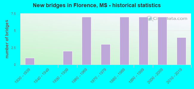
- New bridges - historical statistics
- 11930-1939
- 21950-1959
- 71960-1969
- 31970-1979
- 71980-1989
- 71990-1999
- 72000-2009
- 42010-2019
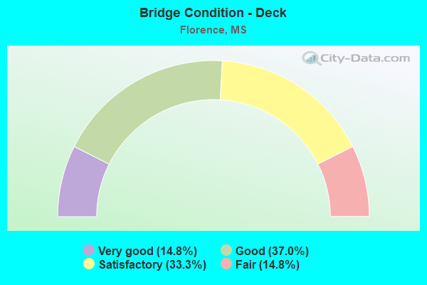
- Bridge Condition - Deck
- 14.8%Very good
- 37.0%Good
- 33.3%Satisfactory
- 14.8%Fair
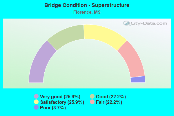
- Bridge Condition - Superstructure
- 25.9%Very good
- 22.2%Good
- 25.9%Satisfactory
- 22.2%Fair
- 3.7%Poor
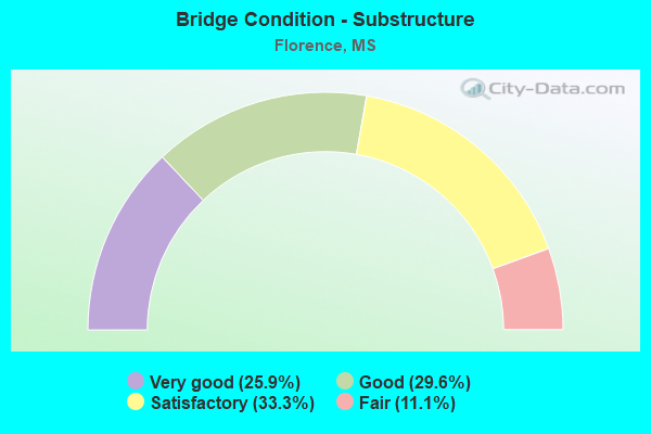
- Bridge Condition - Substructure
- 25.9%Very good
- 29.6%Good
- 33.3%Satisfactory
- 11.1%Fair
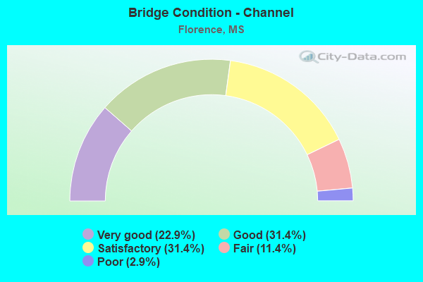
- Bridge Condition - Channel
- 22.9%Very good
- 31.4%Good
- 31.4%Satisfactory
- 11.4%Fair
- 2.9%Poor
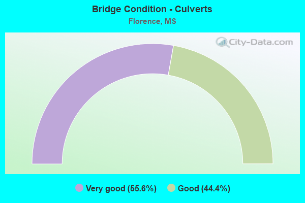
- Bridge Condition - Culverts
- 55.6%Very good
- 44.4%Good
Find on map >> Show street view
Structure Number: 21000490611444, Location: 8.1 MI N SIMPSON CL (Lat: 32.131553, Lng: -90.085367), Route carried "on" structure: US 49, Year Built: 1935, Status: Open, Structure Length: 1.46m (4.79ft), Average Daily Traffic: 20,000 (year 2020), Truck Traffic: 17%, Average Future Daily Traffic: 20,000 (year 2040), Design Load: HS 15, Features Intersected: CREEK
Minimum Vertical Clearance: 30+ m (98+ ft), Kilometerpoint: 13.250, Lanes on structure: 4, Base Highway Network: Yes (Inventory Route: 4, Subroute: 1), Owner: State Highway Agency, Approaching Roadway Width: 12.1m (39.7ft), Skew: 14 degrees, Material/Design: Concrete, Design/Construction: Culvert, Number Of Spans In Main Unit: 2, Length of Maximum Span: 4.9m (16.1ft)
Condition: Channel: Very good, Culverts: Very good, Operating Rating: 71.1 metric tons, Method Used To Determine Operating Rating: Load Factor (LF), Inventory Rating: 42.3 metric tons, Method Used To Determine Inventory Rating: Load Factor (LF), Structural Evaluation: Equal to present desirable criteria, Waterway Adequacy: Equal to present desirable criteria, Approach Roadway Alignment: Equal to present desirable criteria, Length Of Structure Improvement: 1.46m (4.79ft), Designated Inspection Frequency: Every 24 months, Inspection Date: November 2020, Bridge Improvement Cost: $183,000,000, Roadway Improvement Cost: $200,000,000, Total Project Cost: $444,000,000
Find on map >> Show street view
Structure Number: 21000490611452, Location: 9.0 MI N SIMPSON CL (Lat: 32.141008, Lng: -90.098069), Route carried "on" structure: US 49, Year Built: 1963, Status: Open, Structure Length: 0.98m (3.22ft), Average Daily Traffic: 20,000 (year 2020), Truck Traffic: 17%, Average Future Daily Traffic: 20,000 (year 2040), Design Load: HS 20, Features Intersected: DITCH
Minimum Vertical Clearance: 30+ m (98+ ft), Kilometerpoint: 14.841, Lanes on structure: 4, Base Highway Network: Yes (Inventory Route: 4, Subroute: 1), Owner: State Highway Agency, Approaching Roadway Width: 12.1m (39.7ft), Skew: 14 degrees, Material/Design: Concrete, Design/Construction: Culvert, Number Of Spans In Main Unit: 2, Length of Maximum Span: 3.0m (9.8ft)
Condition: Channel: Very good, Culverts: Very good, Operating Rating: 85.5 metric tons, Method Used To Determine Operating Rating: Load Factor (LF), Inventory Rating: 51.3 metric tons, Method Used To Determine Inventory Rating: Load Factor (LF), Structural Evaluation: Equal to present desirable criteria, Waterway Adequacy: Equal to present desirable criteria, Approach Roadway Alignment: Equal to present desirable criteria, Designated Inspection Frequency: Every 24 months, Inspection Date: November 2020
Find on map >> Show street view
Structure Number: 21000490611461A, Location: 0.9 MI S SR 469 (Lat: 32.147761, Lng: -90.111522), Route carried "on" structure: US 49, Year Built: 1967, Status: Open, Structure Length: 4.57m (14.99ft), Average Daily Traffic: 10,000 (year 2020), Truck Traffic: 17%, Average Future Daily Traffic: 10,000 (year 2040), Design Load: HS 20, Features Intersected: STEEN CREEK
Minimum Vertical Clearance: 30+ m (98+ ft), Kilometerpoint: 16.034, Lanes on structure: 2, Base Highway Network: Yes (Inventory Route: 4, Subroute: 1), Owner: State Highway Agency, Approaching Roadway Width: 12.2m (40.0ft), Material/Design: Concrete, Design/Construction: Slab, Number Of Spans In Main Unit: 5, Length of Maximum Span: 9.1m (29.9ft), Curb or Sidewalk Widths: Left: 0.5m (1.6ft), Right: 0.5m (1.6ft), Curb-To-Curb Width: 8.5m (27.9ft), Out-to-Out Width: 10.0m (32.8ft)
Condition: Deck: Fair, Superstructure: Fair, Substructure: Very good, Channel: Good, Operating Rating: 54.9 metric tons, Method Used To Determine Operating Rating: Load Factor (LF), Inventory Rating: 32.8 metric tons, Method Used To Determine Inventory Rating: Load Factor (LF), Structural Evaluation: Somewhat better than minimum adequacy, Deck Geometry: High priority of corrective action, Waterway Adequacy: Equal to present desirable criteria, Approach Roadway Alignment: Equal to present desirable criteria, Length Of Structure Improvement: 5.91m (19.39ft), Designated Inspection Frequency: Every 24 months, Inspection Date: November 2020, Bridge Improvement Cost: $533,000,000, Roadway Improvement Cost: $53,000,000, Total Project Cost: $999,999,000, Deck Structure Type: Concrete Cast-file-Place
Find on map >> Show street view
Structure Number: 21000490611461B, Location: 0.9 MI S SR 469 (Lat: 32.147722, Lng: -90.111003), Route carried "on" structure: US 49, Year Built: 1963, Status: Open, Structure Length: 4.57m (14.99ft), Average Daily Traffic: 10,000 (year 2020), Truck Traffic: 17%, Average Future Daily Traffic: 10,000 (year 2040), Design Load: HS 20, Features Intersected: STEEN CREEK
Minimum Vertical Clearance: 30+ m (98+ ft), Kilometerpoint: 16.275, Lanes on structure: 2, Base Highway Network: Yes (Inventory Route: 4, Subroute: 1), Owner: State Highway Agency, Approaching Roadway Width: 12.2m (40.0ft), Material/Design: Concrete, Design/Construction: Slab, Number Of Spans In Main Unit: 5, Length of Maximum Span: 9.1m (29.9ft), Curb or Sidewalk Widths: Left: 0.5m (1.6ft), Right: 0.5m (1.6ft), Curb-To-Curb Width: 8.5m (27.9ft), Out-to-Out Width: 10.0m (32.8ft)
Condition: Deck: Satisfactory, Superstructure: Satisfactory, Substructure: Very good, Channel: Very good, Operating Rating: 54.9 metric tons, Method Used To Determine Operating Rating: Load Factor (LF), Inventory Rating: 32.8 metric tons, Method Used To Determine Inventory Rating: Load Factor (LF), Structural Evaluation: Equal to present minimum criteria, Deck Geometry: High priority of corrective action, Waterway Adequacy: Equal to present desirable criteria, Approach Roadway Alignment: Equal to present desirable criteria, Length Of Structure Improvement: 5.91m (19.39ft), Designated Inspection Frequency: Every 24 months, Inspection Date: November 2020, Bridge Improvement Cost: $533,000,000, Roadway Improvement Cost: $53,000,000, Total Project Cost: $999,999,000, Deck Structure Type: Concrete Cast-file-Place
Find on map >> Show street view
Structure Number: 21000490611464, Location: 0.6 MI S SR 469 (Lat: 32.149708, Lng: -90.115300), Route carried "on" structure: US 49, Year Built: 1963, Status: Open, Structure Length: 1.01m (3.31ft), Average Daily Traffic: 20,000 (year 2020), Truck Traffic: 17%, Average Future Daily Traffic: 20,000 (year 2040), Design Load: HS 20, Features Intersected: BUTLER CREEK
Minimum Vertical Clearance: 30+ m (98+ ft), Kilometerpoint: 16.737, Lanes on structure: 4, Base Highway Network: Yes (Inventory Route: 4, Subroute: 1), Owner: State Highway Agency, Approaching Roadway Width: 12.1m (39.7ft), Skew: 10 degrees, Material/Design: Concrete, Design/Construction: Culvert, Number Of Spans In Main Unit: 2, Length of Maximum Span: 4.6m (15.1ft)
Condition: Channel: Very good, Culverts: Very good, Operating Rating: 46.8 metric tons, Method Used To Determine Operating Rating: Load Factor (LF), Inventory Rating: 27.9 metric tons, Method Used To Determine Inventory Rating: Load Factor (LF), Structural Evaluation: Better than present minimum criteria, Waterway Adequacy: Equal to present desirable criteria, Approach Roadway Alignment: Equal to present desirable criteria, Designated Inspection Frequency: Every 24 months, Inspection Date: November 2020
Find on map >> Show street view
Structure Number: 21000490611471, Location: 0.2 MI N SR 469 NORTH (Lat: 32.155653, Lng: -90.125119), Route carried "on" structure: US 49, Year Built: 1963, Status: Open, Structure Length: 1.49m (4.89ft), Average Daily Traffic: 34,000 (year 2020), Truck Traffic: 15%, Average Future Daily Traffic: 34,000 (year 2040), Design Load: HS 20, Features Intersected: INDIAN CREEK TRIB #1
Minimum Vertical Clearance: 30+ m (98+ ft), Kilometerpoint: 17.885, Lanes on structure: 4, Base Highway Network: Yes (Inventory Route: 4, Subroute: 1), Owner: State Highway Agency, Approaching Roadway Width: 12.1m (39.7ft), Skew: 14 degrees, Material/Design: Concrete, Design/Construction: Culvert, Number Of Spans In Main Unit: 2, Length of Maximum Span: 4.9m (16.1ft)
Condition: Channel: Satisfactory, Culverts: Very good, Operating Rating: 42.3 metric tons, Method Used To Determine Operating Rating: Load Factor (LF), Inventory Rating: 25.2 metric tons, Method Used To Determine Inventory Rating: Load Factor (LF), Structural Evaluation: Equal to present minimum criteria, Waterway Adequacy: Equal to present desirable criteria, Approach Roadway Alignment: Equal to present desirable criteria, Length Of Structure Improvement: 1.49m (4.89ft), Designated Inspection Frequency: Every 24 months, Inspection Date: November 2020, Bridge Improvement Cost: $187,000,000, Roadway Improvement Cost: $200,000,000, Total Project Cost: $449,000,000
Find on map >> Show street view
Structure Number: 21000490611491, Location: 2.2 MI N SR 469 (Lat: 32.184292, Lng: -90.136939), Route carried "on" structure: US 49, Year Built: 1967, Status: Open, Structure Length: 0.79m (2.59ft), Average Daily Traffic: 38,000 (year 2020), Truck Traffic: 14%, Average Future Daily Traffic: 38,000 (year 2040), Design Load: HS 20, Features Intersected: STREAM
Minimum Vertical Clearance: 30+ m (98+ ft), Kilometerpoint: 21.261, Lanes on structure: 4, Base Highway Network: Yes (Inventory Route: 4, Subroute: 1), Owner: State Highway Agency, Approaching Roadway Width: 10.6m (34.8ft), Skew: 10 degrees, Material/Design: Concrete, Design/Construction: Culvert, Number Of Spans In Main Unit: 2, Length of Maximum Span: 3.7m (12.1ft)
Condition: Channel: Very good, Culverts: Very good, Operating Rating: 46.8 metric tons, Method Used To Determine Operating Rating: Load Factor (LF), Inventory Rating: 27.9 metric tons, Method Used To Determine Inventory Rating: Load Factor (LF), Structural Evaluation: Better than present minimum criteria, Waterway Adequacy: Equal to present desirable criteria, Approach Roadway Alignment: Equal to present desirable criteria, Length Of Structure Improvement: 0.79m (2.59ft), Designated Inspection Frequency: Every 24 months, Inspection Date: November 2020, Bridge Improvement Cost: $81,000,000, Roadway Improvement Cost: $200,000,000, Total Project Cost: $347,000,000
Find on map >> Show street view
Structure Number: 31004630450002, Location: 0.2 MI N US 51 (Lat: 32.464356, Lng: -90.112589), Route carried "on" structure: State highway 463, Year Built: 2012, Status: Open, Structure Length: 39.16m (128.48ft), Average Daily Traffic: 23,000 (year 2020), Truck Traffic: 4%, Average Future Daily Traffic: 23,000 (year 2040), Design Load: HL 93, Features Intersected: HOY ROAD & CNIC RR
Minimum Vertical Clearance: 30+ m (98+ ft), Kilometerpoint: 0.312, Lanes on structure: 4, Lanes under structure: 2, Base Highway Network: Yes (Inventory Route: 46, Subroute: 1), Owner: State Highway Agency, Approaching Roadway Width: 14.6m (47.9ft), Skew: 23 degrees, Material/Design: Steel continuous, Design/Construction: Stringer/Multi-beam, Number Of Spans In Main Unit: 7, Length of Maximum Span: 61.0m (200.1ft), Curb or Sidewalk Widths: Left: 2.7m (8.9ft), Right: 2.7m (8.9ft), Curb-To-Curb Width: 25.6m (84.0ft), Out-to-Out Width: 26.2m (86.0ft)
Condition: Deck: Very good, Superstructure: Very good, Substructure: Very good, Operating Rating: 49.6 metric tons, Method Used To Determine Operating Rating: Load and Resistance Factor (LRFR), Inventory Rating: 38.3 metric tons, Method Used To Determine Inventory Rating: Load and Resistance Factor (LRFR), Structural Evaluation: Equal to present desirable criteria, Deck Geometry: Superior to present desirable criteria, Underclear: Somewhat better than minimum adequacy, Approach Roadway Alignment: Equal to present desirable criteria, Designated Inspection Frequency: Every 24 months, Inspection Date: October 2020, Deck Structure Type: Concrete Cast-file-Place
Find on map >> Show street view
Structure Number: 31004690610172, Location: 2.4 MI N SIMPSON CL (Lat: 32.082547, Lng: -90.132689), Route carried "on" structure: State highway 469, Year Built: 1980, Status: Open, Structure Length: 2.93m (9.61ft), Average Daily Traffic: 3,700 (year 2020), Truck Traffic: 10%, Average Future Daily Traffic: 4,600 (year 2040), Design Load: H 15, Features Intersected: HOMINY CREEK
Minimum Vertical Clearance: 30+ m (98+ ft), Kilometerpoint: 3.896, Lanes on structure: 2, Base Highway Network: Yes (Inventory Route: 46, Subroute: 1), Owner: State Highway Agency, Approaching Roadway Width: 8.5m (27.9ft), Material/Design: Concrete, Design/Construction: Channel Beam, Number Of Spans In Main Unit: 5, Length of Maximum Span: 5.8m (19.0ft), Curb-To-Curb Width: 8.1m (26.6ft), Out-to-Out Width: 8.5m (27.9ft)
Condition: Deck: Fair, Superstructure: Fair, Substructure: Satisfactory, Channel: Very good, Operating Rating: 50.5 metric tons, Method Used To Determine Operating Rating: Load Factor (LF), Inventory Rating: 30.3 metric tons, Method Used To Determine Inventory Rating: Load Factor (LF), Structural Evaluation: Somewhat better than minimum adequacy, Deck Geometry: High priority of corrective action, Waterway Adequacy: Equal to present desirable criteria, Approach Roadway Alignment: Better than present minimum criteria, Length Of Structure Improvement: 4.01m (13.16ft), Designated Inspection Frequency: Every 12 months, Inspection Date: October 2021, Bridge Improvement Cost: $311,000,000, Roadway Improvement Cost: $31,000,000, Total Project Cost: $927,000,000, Deck Structure Type: Concrete Precast Panels
Find on map >> Show street view
Structure Number: 31004690610191, Location: 4.3 MI N SIMPSON CL (Lat: 32.108639, Lng: -90.129111), Route carried "on" structure: State highway 469, Year Built: 1955, Status: Open, Structure Length: 3.05m (10.01ft), Average Daily Traffic: 3,700 (year 2020), Truck Traffic: 10%, Average Future Daily Traffic: 4,600 (year 2040), Design Load: H 15, Features Intersected: MOUNTAIN CREEK
Minimum Vertical Clearance: 30+ m (98+ ft), Kilometerpoint: 6.928, Lanes on structure: 2, Base Highway Network: Yes (Inventory Route: 46, Subroute: 1), Owner: State Highway Agency, Approaching Roadway Width: 8.5m (27.9ft), Material/Design: Concrete, Design/Construction: Slab, Number Of Spans In Main Unit: 5, Length of Maximum Span: 6.1m (20.0ft), Curb or Sidewalk Widths: Left: 0.5m (1.6ft), Right: 0.5m (1.6ft), Curb-To-Curb Width: 7.3m (24.0ft), Out-to-Out Width: 8.4m (27.6ft)
Condition: Deck: Good, Superstructure: Good, Substructure: Good, Channel: Fair, Operating Rating: 49.6 metric tons, Method Used To Determine Operating Rating: Load Factor (LF), Inventory Rating: 29.7 metric tons, Method Used To Determine Inventory Rating: Load Factor (LF), Structural Evaluation: Better than present minimum criteria, Deck Geometry: High priority of replacement, Waterway Adequacy: Meets minimum limits, Approach Roadway Alignment: Equal to present minimum criteria, Length Of Structure Improvement: 3.96m (12.99ft), Designated Inspection Frequency: Every 24 months, Inspection Date: October 2020, Bridge Improvement Cost: $307,000,000, Roadway Improvement Cost: $31,000,000, Total Project Cost: $915,000,000, Deck Structure Type: Concrete Cast-file-Place
Find on map >> Show street view
Structure Number: 31004690610213, Location: 6.4 MI N SIMPSON CL (Lat: 32.138450, Lng: -90.128531), Route carried "on" structure: State highway 469, Year Built: 1955, Status: Posted for load, Structure Length: 5.79m (19.00ft), Average Daily Traffic: 6,300 (year 2020), Truck Traffic: 6%, Average Future Daily Traffic: 6,300 (year 2040), Design Load: H 15, Features Intersected: STEEN CREEK
Minimum Vertical Clearance: 30+ m (98+ ft), Kilometerpoint: 10.422, Lanes on structure: 2, Owner: State Highway Agency, Approaching Roadway Width: 8.5m (27.9ft), Material/Design: Steel, Design/Construction: Stringer/Multi-beam, Number Of Spans In Main Unit: 1, Number Of Approach Spans: 5, Length of Maximum Span: 12.2m (40.0ft), Curb or Sidewalk Widths: Left: 0.5m (1.6ft), Right: 0.5m (1.6ft), Curb-To-Curb Width: 7.3m (24.0ft), Out-to-Out Width: 8.4m (27.6ft)
Condition: Deck: Fair, Superstructure: Fair, Substructure: Satisfactory, Channel: Good, Operating Rating: 37.2 metric tons, Method Used To Determine Operating Rating: Load Factor (LF), Inventory Rating: 22.2 metric tons, Method Used To Determine Inventory Rating: Load Factor (LF), Structural Evaluation: Somewhat better than minimum adequacy, Deck Geometry: High priority of replacement, Waterway Adequacy: Equal to present desirable criteria, Approach Roadway Alignment: Equal to present desirable criteria, Bridge Posting: Required (Relationship of Operating Rating to Maximum Legal Load: 0.1 - 9.9% below), Length Of Structure Improvement: 7.46m (24.48ft), Designated Inspection Frequency: Every 12 months, Inspection Date: October 2021, Bridge Improvement Cost: $685,000,000, Roadway Improvement Cost: $69,000,000, Total Project Cost: $999,999,000, Deck Structure Type: Concrete Cast-file-Place
Find on map >> Show street view
Structure Number: 31004690610229, Location: 0.1 MI N US 49 (Lat: 32.154811, Lng: -90.122761), Route carried "on" structure: State highway 469, Year Built: 1986, Status: Open, Structure Length: 2.83m (9.28ft), Average Daily Traffic: 8,500 (year 2020), Truck Traffic: 6%, Average Future Daily Traffic: 8,500 (year 2040), Design Load: HS 20, Features Intersected: INDIAN CREEK RELIEF
Minimum Vertical Clearance: 30+ m (98+ ft), Kilometerpoint: 12.984, Lanes on structure: 2, Owner: State Highway Agency, Approaching Roadway Width: 15.8m (51.8ft), Material/Design: Prestressed concrete, Design/Construction: Slab, Number Of Spans In Main Unit: 3, Length of Maximum Span: 9.4m (30.8ft), Curb-To-Curb Width: 15.8m (51.8ft), Out-to-Out Width: 16.7m (54.8ft)
Condition: Deck: Very good, Superstructure: Very good, Substructure: Fair, Channel: Very good, Operating Rating: 43.7 metric tons, Method Used To Determine Operating Rating: Load Factor (LF), Inventory Rating: 26.2 metric tons, Method Used To Determine Inventory Rating: Load Factor (LF), Structural Evaluation: Somewhat better than minimum adequacy, Deck Geometry: Superior to present desirable criteria, Waterway Adequacy: Equal to present desirable criteria, Approach Roadway Alignment: Equal to present desirable criteria, Designated Inspection Frequency: Every 24 months, Inspection Date: October 2020, Deck Structure Type: Concrete Cast-file-Place
Find on map >> Show street view
Structure Number: 3100469061023, Location: 0.2 MI N US 49 (Lat: 32.155122, Lng: -90.121867), Route carried "on" structure: State highway 469, Year Built: 1986, Status: Open, Structure Length: 4.88m (16.01ft), Average Daily Traffic: 8,500 (year 2020), Truck Traffic: 6%, Average Future Daily Traffic: 8,500 (year 2040), Design Load: HS 20, Features Intersected: INDIAN CREEK
Minimum Vertical Clearance: 30+ m (98+ ft), Kilometerpoint: 13.074, Lanes on structure: 2, Owner: State Highway Agency, Approaching Roadway Width: 15.8m (51.8ft), Material/Design: Prestressed concrete, Design/Construction: Slab, Number Of Spans In Main Unit: 4, Length of Maximum Span: 12.2m (40.0ft), Curb-To-Curb Width: 15.8m (51.8ft), Out-to-Out Width: 16.7m (54.8ft)
Condition: Deck: Very good, Superstructure: Very good, Substructure: Fair, Channel: Good, Operating Rating: 63.3 metric tons, Method Used To Determine Operating Rating: Load Factor (LF), Inventory Rating: 37.9 metric tons, Method Used To Determine Inventory Rating: Load Factor (LF), Structural Evaluation: Somewhat better than minimum adequacy, Deck Geometry: Superior to present desirable criteria, Waterway Adequacy: Equal to present desirable criteria, Approach Roadway Alignment: Equal to present desirable criteria, Designated Inspection Frequency: Every 24 months, Inspection Date: October 2020, Deck Structure Type: Concrete Cast-file-Place
Find on map >> Show street view
Structure Number: 31004690610291, Location: 1.6 MI S SR 468 (Lat: 32.206117, Lng: -90.054950), Route carried "on" structure: State highway 469, Year Built: 1986, Status: Open, Structure Length: 4.63m (15.19ft), Average Daily Traffic: 4,500 (year 2020), Truck Traffic: 6%, Average Future Daily Traffic: 4,500 (year 2040), Design Load: HS 20, Features Intersected: RICHLAND CREEK
Minimum Vertical Clearance: 30+ m (98+ ft), Kilometerpoint: 22.927, Lanes on structure: 2, Owner: State Highway Agency, Approaching Roadway Width: 11.0m (36.1ft), Material/Design: Prestressed concrete, Design/Construction: Stringer/Multi-beam, Number Of Spans In Main Unit: 1, Number Of Approach Spans: 2, Length of Maximum Span: 21.3m (69.9ft), Curb-To-Curb Width: 11.0m (36.1ft), Out-to-Out Width: 11.8m (38.7ft)
Condition: Deck: Good, Superstructure: Very good, Substructure: Very good, Channel: Good, Operating Rating: 41.7 metric tons, Method Used To Determine Operating Rating: Load Factor (LF), Inventory Rating: 36.7 metric tons, Method Used To Determine Inventory Rating: Load Factor (LF), Structural Evaluation: Equal to present desirable criteria, Deck Geometry: Somewhat better than minimum adequacy, Waterway Adequacy: Equal to present desirable criteria, Approach Roadway Alignment: Equal to present desirable criteria, Designated Inspection Frequency: Every 24 months, Inspection Date: October 2020, Deck Structure Type: Concrete Cast-file-Place
Find on map >> Show street view
Structure Number: SA6100000000006, Location: SEC 13 T 3N R 1E (Lat: 32.094167, Lng: -90.156861), Route carried "on" structure: County highway 467, Year Built: 1999, Status: Open, Structure Length: 2.11m (6.92ft), Average Daily Traffic: 500 (year 2020), Truck Traffic: 8%, Average Future Daily Traffic: 750 (year 2040), Design Load: H 15, Features Intersected: BCH OF MOUNTAIN CREEK, Facility Carried by Structure: OLD ENOCHS RD.
Minimum Vertical Clearance: 30+ m (98+ ft), Kilometerpoint: 2.735, Lanes on structure: 2, Owner: County Highway Agency, Approaching Roadway Width: 6.4m (21.0ft), Material/Design: Concrete, Design/Construction: Channel Beam, Number Of Spans In Main Unit: 3, Length of Maximum Span: 9.4m (30.8ft), Curb or Sidewalk Widths: Left: 0.2m (0.7ft), Right: 0.2m (0.7ft), Curb-To-Curb Width: 7.1m (23.3ft), Out-to-Out Width: 7.5m (24.6ft)
Condition: Deck: Satisfactory, Superstructure: Satisfactory, Substructure: Good, Channel: Good, Operating Rating: 55.2 metric tons, Method Used To Determine Operating Rating: Load Factor (LF), Inventory Rating: 33.0 metric tons, Method Used To Determine Inventory Rating: Load Factor (LF), Structural Evaluation: Equal to present minimum criteria, Deck Geometry: Meets minimum limits, Waterway Adequacy: Equal to present minimum criteria, Approach Roadway Alignment: Equal to present minimum criteria, Length Of Structure Improvement: 2.83m (9.28ft), Designated Inspection Frequency: Every 24 months, Inspection Date: November 2020, Bridge Improvement Cost: $169,000, Roadway Improvement Cost: $17,000, Total Project Cost: $208,000 ( Estimate for 2020), Deck Structure Type: Concrete Precast Panels, Wearing Surface/Protective System: Wearing Surface: Monolithic Concrete
Find on map >> Show street view
Structure Number: SA6100000000007, Location: SEC 14 T 3N R 1E (Lat: 32.101389, Lng: -90.166167), Route carried "on" structure: County highway 466, Year Built: 1989, Status: Open, Structure Length: 2.10m (6.89ft), Average Daily Traffic: 500 (year 2020), Truck Traffic: 8%, Average Future Daily Traffic: 750 (year 2040), Design Load: H 15, Features Intersected: MOUNTAIN CREEK, Facility Carried by Structure: FOSTER RD
Minimum Vertical Clearance: 30+ m (98+ ft), Kilometerpoint: 4.667, Lanes on structure: 2, Owner: County Highway Agency, Approaching Roadway Width: 6.1m (20.0ft), Material/Design: Concrete, Design/Construction: Channel Beam, Number Of Spans In Main Unit: 3, Length of Maximum Span: 9.4m (30.8ft), Curb or Sidewalk Widths: Left: 0.2m (0.7ft), Right: 0.2m (0.7ft), Curb-To-Curb Width: 7.1m (23.3ft), Out-to-Out Width: 7.5m (24.6ft)
Condition: Deck: Good, Superstructure: Good, Substructure: Good, Channel: Satisfactory, Operating Rating: 55.2 metric tons, Method Used To Determine Operating Rating: Load Factor (LF), Inventory Rating: 33.0 metric tons, Method Used To Determine Inventory Rating: Load Factor (LF), Structural Evaluation: Better than present minimum criteria, Deck Geometry: Meets minimum limits, Waterway Adequacy: Equal to present minimum criteria, Approach Roadway Alignment: Equal to present minimum criteria, Length Of Structure Improvement: 2.83m (9.28ft), Designated Inspection Frequency: Every 24 months, Inspection Date: November 2020, Bridge Improvement Cost: $169,000, Roadway Improvement Cost: $17,000, Total Project Cost: $208,000 ( Estimate for 2020), Deck Structure Type: Concrete Precast Panels, Wearing Surface/Protective System: Wearing Surface: Bituminous
Find on map >> Show street view
Structure Number: SA6100000000011, Location: SEC 1 T 3N R 2E (Lat: 32.129469, Lng: -90.044389), Route carried "on" structure: County highway 434, Year Built: 1984, Status: Open, Structure Length: 2.10m (6.89ft), Average Daily Traffic: 150 (year 2018), Truck Traffic: 8%, Average Future Daily Traffic: 225 (year 2038), Design Load: H 15, Features Intersected: STEEN CREEK, Facility Carried by Structure: MCCOLOUGH MCLIN RD
Minimum Vertical Clearance: 30+ m (98+ ft), Kilometerpoint: 1.126, Lanes on structure: 2, Owner: County Highway Agency, Approaching Roadway Width: 5.5m (18.0ft), Skew: 3 degrees, Material/Design: Concrete, Design/Construction: Channel Beam, Number Of Spans In Main Unit: 3, Length of Maximum Span: 9.4m (30.8ft), Curb or Sidewalk Widths: Left: 0.2m (0.7ft), Right: 0.2m (0.7ft), Curb-To-Curb Width: 7.1m (23.3ft), Out-to-Out Width: 7.5m (24.6ft)
Condition: Deck: Satisfactory, Superstructure: Satisfactory, Substructure: Satisfactory, Channel: Fair, Operating Rating: 55.2 metric tons, Method Used To Determine Operating Rating: Load Factor (LF), Inventory Rating: 33.0 metric tons, Method Used To Determine Inventory Rating: Load Factor (LF), Structural Evaluation: Equal to present minimum criteria, Deck Geometry: Meets minimum limits, Waterway Adequacy: Equal to present desirable criteria, Approach Roadway Alignment: Equal to present minimum criteria, Length Of Structure Improvement: 2.38m (7.81ft), Designated Inspection Frequency: Every 12 months, Inspection Date: December 2021, Bridge Improvement Cost: $142,000, Roadway Improvement Cost: $15,000, Total Project Cost: $175,000 ( Estimate for 2018), Deck Structure Type: Concrete Precast Panels
Find on map >> Show street view
Structure Number: SA6100000000012, Location: SEC 2 T 3N R 2E (Lat: 32.130428, Lng: -90.059350), Route carried "on" structure: County highway 438, Year Built: 2004, Status: Open, Structure Length: 1.22m (4.00ft), Average Daily Traffic: 180 (year 2018), Truck Traffic: 8%, Average Future Daily Traffic: 270 (year 2038), Design Load: HS 20, Features Intersected: STEEN CREEK, Facility Carried by Structure: J T BRADDY RD
Minimum Vertical Clearance: 30+ m (98+ ft), Kilometerpoint: 4.667, Lanes on structure: 2, Owner: County Highway Agency, Approaching Roadway Width: 6.1m (20.0ft), Skew: 1 degrees, Material/Design: Concrete, Design/Construction: Culvert, Number Of Spans In Main Unit: 2, Length of Maximum Span: 5.5m (18.0ft)
Condition: Channel: Satisfactory, Culverts: Good, Operating Rating: 91.2 metric tons, Method Used To Determine Operating Rating: Load Factor (LF), Inventory Rating: 54.6 metric tons, Method Used To Determine Inventory Rating: Load Factor (LF), Structural Evaluation: Better than present minimum criteria, Waterway Adequacy: Equal to present desirable criteria, Approach Roadway Alignment: Equal to present minimum criteria, Designated Inspection Frequency: Every 24 months, Inspection Date: December 2020
Find on map >> Show street view
Structure Number: SA6100000000013, Location: SEC 5 T 3N R 2E (Lat: 32.137083, Lng: -90.125389), Route carried "on" structure: City street 1534, Year Built: 1991, Status: Posted for load, Structure Length: 0.94m (3.08ft), Average Daily Traffic: 250 (year 2021), Truck Traffic: 8%, Average Future Daily Traffic: 375 (year 2041), Design Load: H 15, Features Intersected: BRANCH OF STEEN CREEK, Facility Carried by Structure: ERLICH RD
Minimum Vertical Clearance: 30+ m (98+ ft), Kilometerpoint: 10.460, Lanes on structure: 2, Owner: Town or Township Highway Agency, Approaching Roadway Width: 6.1m (20.0ft), Material/Design: Concrete, Design/Construction: Channel Beam, Number Of Spans In Main Unit: 1, Length of Maximum Span: 9.4m (30.8ft), Curb or Sidewalk Widths: Left: 0.2m (0.7ft), Right: 0.2m (0.7ft), Curb-To-Curb Width: 7.1m (23.3ft), Out-to-Out Width: 7.5m (24.6ft)
Condition: Deck: Fair, Superstructure: Fair, Substructure: Fair, Channel: Poor, Operating Rating: 21.6 metric tons, Method Used To Determine Operating Rating: Load Factor (LF), Inventory Rating: 13.0 metric tons, Method Used To Determine Inventory Rating: Load Factor (LF), Structural Evaluation: Meets minimum limits, Deck Geometry: Meets minimum limits, Waterway Adequacy: Somewhat better than minimum adequacy, Approach Roadway Alignment: Equal to present desirable criteria, Bridge Posting: Required (Relationship of Operating Rating to Maximum Legal Load: > 39.9% below), Length Of Structure Improvement: 1.74m (5.71ft), Designated Inspection Frequency: Every 12 months, Inspection Date: November 2021, Bridge Improvement Cost: $103,000, Roadway Improvement Cost: $10,000, Total Project Cost: $127,000 ( Estimate for 2021), Deck Structure Type: Concrete Precast Panels, Wearing Surface/Protective System: Wearing Surface: Monolithic Concrete
Find on map >> Show street view
Structure Number: SA6100000000015, Location: SEC 18 T 3N R 2E (Lat: 32.097556, Lng: -90.140472), Route carried "on" structure: County highway 467, Year Built: 2006, Status: Open, Structure Length: 3.26m (10.70ft), Average Daily Traffic: 500 (year 2020), Truck Traffic: 8%, Average Future Daily Traffic: 750 (year 2040), Design Load: HS 20, Features Intersected: HOMINY CREEK, Facility Carried by Structure: OLD ENOCHS RD.
Minimum Vertical Clearance: 30+ m (98+ ft), Kilometerpoint: 4.345, Lanes on structure: 2, Owner: County Highway Agency, Approaching Roadway Width: 6.4m (21.0ft), Material/Design: Concrete, Design/Construction: Channel Beam, Number Of Spans In Main Unit: 5, Length of Maximum Span: 9.4m (30.8ft), Curb or Sidewalk Widths: Left: 0.2m (0.7ft), Right: 0.2m (0.7ft), Curb-To-Curb Width: 8.1m (26.6ft), Out-to-Out Width: 8.5m (27.9ft)
Condition: Deck: Good, Superstructure: Good, Substructure: Good, Channel: Good, Operating Rating: 75.5 metric tons, Method Used To Determine Operating Rating: Load Factor (LF), Inventory Rating: 45.4 metric tons, Method Used To Determine Inventory Rating: Load Factor (LF), Structural Evaluation: Better than present minimum criteria, Deck Geometry: Somewhat better than minimum adequacy, Waterway Adequacy: Better than present minimum criteria, Approach Roadway Alignment: Equal to present desirable criteria, Designated Inspection Frequency: Every 24 months, Inspection Date: November 2020, Deck Structure Type: Concrete Precast Panels, Wearing Surface/Protective System: Wearing Surface: Monolithic Concrete
Find on map >> Show street view
Structure Number: SA6100000000016, Location: SEC 21 T 3N R 2E (Lat: 32.090889, Lng: -90.094583), Route carried "on" structure: County highway 462, Year Built: 1994, Status: Open, Structure Length: 0.94m (3.08ft), Average Daily Traffic: 50 (year 2021), Truck Traffic: 10%, Average Future Daily Traffic: 75 (year 2041), Design Load: H 15, Features Intersected: MOUNTAIN CREEK RELIEF, Facility Carried by Structure: TRAYLOR ROAD
Minimum Vertical Clearance: 30+ m (98+ ft), Kilometerpoint: 3.379, Lanes on structure: 2, Owner: County Highway Agency, Approaching Roadway Width: 6.1m (20.0ft), Material/Design: Concrete, Design/Construction: Channel Beam, Number Of Spans In Main Unit: 1, Length of Maximum Span: 9.4m (30.8ft), Curb or Sidewalk Widths: Left: 0.2m (0.7ft), Right: 0.2m (0.7ft), Curb-To-Curb Width: 7.1m (23.3ft), Out-to-Out Width: 7.5m (24.6ft)
Condition: Deck: Good, Superstructure: Good, Substructure: Good, Channel: Good, Operating Rating: 55.2 metric tons, Method Used To Determine Operating Rating: Load Factor (LF), Inventory Rating: 33.0 metric tons, Method Used To Determine Inventory Rating: Load Factor (LF), Structural Evaluation: Better than present minimum criteria, Deck Geometry: Somewhat better than minimum adequacy, Waterway Adequacy: Equal to present minimum criteria, Approach Roadway Alignment: Equal to present desirable criteria, Length Of Structure Improvement: 1.74m (5.71ft), Designated Inspection Frequency: Every 24 months, Inspection Date: November 2021, Bridge Improvement Cost: $103,000, Roadway Improvement Cost: $10,000, Total Project Cost: $127,000 ( Estimate for 2021), Deck Structure Type: Concrete Precast Panels, Wearing Surface/Protective System: Wearing Surface: Monolithic Concrete
Find on map >> Show street view
Structure Number: SA6100000000017, Location: SEC 21 T 3N R 2E (Lat: 32.090333, Lng: -90.094694), Route carried "on" structure: County highway 462, Year Built: 1990, Status: Open, Structure Length: 2.10m (6.89ft), Average Daily Traffic: 150 (year 2020), Truck Traffic: 10%, Average Future Daily Traffic: 275 (year 2040), Design Load: H 15, Features Intersected: MOUNTAIN CREEK, Facility Carried by Structure: TRAYLOR ROAD
Minimum Vertical Clearance: 30+ m (98+ ft), Kilometerpoint: 3.379, Lanes on structure: 2, Owner: County Highway Agency, Approaching Roadway Width: 6.1m (20.0ft), Material/Design: Concrete, Design/Construction: Channel Beam, Number Of Spans In Main Unit: 3, Length of Maximum Span: 9.4m (30.8ft), Curb or Sidewalk Widths: Left: 0.2m (0.7ft), Right: 0.2m (0.7ft), Curb-To-Curb Width: 7.1m (23.3ft), Out-to-Out Width: 7.5m (24.6ft)
Condition: Deck: Satisfactory, Superstructure: Satisfactory, Substructure: Satisfactory, Channel: Fair, Operating Rating: 55.2 metric tons, Method Used To Determine Operating Rating: Load Factor (LF), Inventory Rating: 33.0 metric tons, Method Used To Determine Inventory Rating: Load Factor (LF), Structural Evaluation: Equal to present minimum criteria, Deck Geometry: Meets minimum limits, Waterway Adequacy: Equal to present minimum criteria, Approach Roadway Alignment: Equal to present desirable criteria, Length Of Structure Improvement: 2.83m (9.28ft), Designated Inspection Frequency: Every 24 months, Inspection Date: November 2020, Bridge Improvement Cost: $169,000, Roadway Improvement Cost: $17,000, Total Project Cost: $208,000 ( Estimate for 2020), Deck Structure Type: Concrete Precast Panels, Wearing Surface/Protective System: Wearing Surface: Monolithic Concrete
Find on map >> Show street view
Structure Number: SA6100000000018, Location: SEC 22 T 3N R 2E B (Lat: 32.090186, Lng: -90.089622), Route carried "on" structure: County highway 445, Year Built: 1974, Status: Open, Structure Length: 2.83m (9.28ft), Average Daily Traffic: 430 (year 2020), Truck Traffic: 8%, Average Future Daily Traffic: 645 (year 2040), Design Load: H 15, Features Intersected: MOUNTAIN CREEK, Facility Carried by Structure: LOFLIN ROAD
Minimum Vertical Clearance: 30+ m (98+ ft), Kilometerpoint: 5.149, Lanes on structure: 2, Owner: County Highway Agency, Approaching Roadway Width: 6.7m (22.0ft), Material/Design: Prestressed concrete, Design/Construction: Stringer/Multi-beam, Number Of Spans In Main Unit: 3, Length of Maximum Span: 9.4m (30.8ft), Curb or Sidewalk Widths: Left: 0.5m (1.6ft), Right: 0.5m (1.6ft), Curb-To-Curb Width: 7.9m (25.9ft), Out-to-Out Width: 8.9m (29.2ft)
Condition: Deck: Satisfactory, Superstructure: Good, Substructure: Satisfactory, Channel: Fair, Operating Rating: 58.1 metric tons, Method Used To Determine Operating Rating: Load Factor (LF), Inventory Rating: 40.8 metric tons, Method Used To Determine Inventory Rating: Load Factor (LF), Structural Evaluation: Equal to present minimum criteria, Deck Geometry: Somewhat better than minimum adequacy, Waterway Adequacy: Equal to present desirable criteria, Approach Roadway Alignment: Equal to present desirable criteria, Length Of Structure Improvement: 4.27m (14.01ft), Designated Inspection Frequency: Every 24 months, Inspection Date: November 2020, Bridge Improvement Cost: $255,000, Roadway Improvement Cost: $25,000, Total Project Cost: $314,000 ( Estimate for 2020), Deck Structure Type: Concrete Cast-file-Place, Wearing Surface/Protective System: Wearing Surface: Monolithic Concrete
Find on map >> Show street view
Structure Number: SA610000000002, Location: SEC 23 T 3N R 2E (Lat: 32.086500, Lng: -90.066500), Route carried "on" structure: County highway 451, Year Built: 2003, Status: Open, Structure Length: 0.78m (2.56ft), Average Daily Traffic: 200 (year 2020), Truck Traffic: 10%, Average Future Daily Traffic: 350 (year 2040), Design Load: HS 20, Features Intersected: SANDERS CREEK, Facility Carried by Structure: AINSWORTH ROAD
Minimum Vertical Clearance: 30+ m (98+ ft), Kilometerpoint: 3.701, Lanes on structure: 2, Owner: County Highway Agency, Approaching Roadway Width: 6.1m (20.0ft), Skew: 3 degrees, Material/Design: Concrete, Design/Construction: Culvert, Number Of Spans In Main Unit: 2, Length of Maximum Span: 3.0m (9.8ft)
Condition: Channel: Satisfactory, Culverts: Good, Operating Rating: 51.0 metric tons, Method Used To Determine Operating Rating: Load Factor (LF), Inventory Rating: 30.4 metric tons, Method Used To Determine Inventory Rating: Load Factor (LF), Structural Evaluation: Better than present minimum criteria, Waterway Adequacy: Equal to present minimum criteria, Approach Roadway Alignment: Equal to present minimum criteria, Designated Inspection Frequency: Every 24 months, Inspection Date: November 2020
Find on map >> Show street view
Structure Number: SA6100000000023, Location: SEC 6 T 3N R 3E B (Lat: 32.130272, Lng: -90.028436), Route carried "on" structure: County highway 426, Year Built: 1965, Status: Open, Structure Length: 0.79m (2.59ft), Average Daily Traffic: 3,200 (year 2018), Truck Traffic: 8%, Average Future Daily Traffic: 4,800 (year 2038), Design Load: H 15, Features Intersected: STEEN CREEK, Facility Carried by Structure: STAR RD
Minimum Vertical Clearance: 30+ m (98+ ft), Kilometerpoint: 9.495, Lanes on structure: 2, Owner: County Highway Agency, Approaching Roadway Width: 7.3m (24.0ft), Material/Design: Concrete, Design/Construction: Culvert, Number Of Spans In Main Unit: 2, Length of Maximum Span: 3.7m (12.1ft)
Condition: Channel: Satisfactory, Culverts: Good, Operating Rating: 45.1 metric tons, Method Used To Determine Operating Rating: Load Factor (LF), Inventory Rating: 26.8 metric tons, Method Used To Determine Inventory Rating: Load Factor (LF), Structural Evaluation: Equal to present minimum criteria, Waterway Adequacy: Equal to present desirable criteria, Approach Roadway Alignment: Equal to present desirable criteria, Designated Inspection Frequency: Every 24 months, Inspection Date: January 2021
Find on map >> Show street view
Structure Number: SA6100000000055, Location: SEC 20 T 4N R 2E (Lat: 32.181111, Lng: -90.114500), Route carried "on" structure: County highway 322, Year Built: 2005, Status: Posted for load, Structure Length: 2.32m (7.61ft), Average Daily Traffic: 1,900 (year 2021), Truck Traffic: 8%, Average Future Daily Traffic: 2,850 (year 2041), Design Load: H 15, Features Intersected: INDIAN CREEK, Facility Carried by Structure: GUNTER RD.
Minimum Vertical Clearance: 30+ m (98+ ft), Kilometerpoint: 1.931, Lanes on structure: 2, Owner: County Highway Agency, Approaching Roadway Width: 6.4m (21.0ft), Material/Design: Concrete, Design/Construction: Channel Beam, Number Of Spans In Main Unit: 4, Length of Maximum Span: 5.8m (19.0ft), Curb or Sidewalk Widths: Left: 0.2m (0.7ft), Right: 0.2m (0.7ft), Curb-To-Curb Width: 7.1m (23.3ft), Out-to-Out Width: 7.5m (24.6ft)
Condition: Deck: Good, Superstructure: Fair, Substructure: Satisfactory, Channel: Satisfactory, Operating Rating: 27.8 metric tons, Method Used To Determine Operating Rating: Load Factor (LF), Inventory Rating: 16.7 metric tons, Method Used To Determine Inventory Rating: Load Factor (LF), Structural Evaluation: Meets minimum limits, Deck Geometry: High priority of corrective action, Waterway Adequacy: Equal to present minimum criteria, Approach Roadway Alignment: Equal to present desirable criteria, Bridge Posting: Required (Relationship of Operating Rating to Maximum Legal Load: 30.0 - 39.9% below), Length Of Structure Improvement: 2.83m (9.28ft), Designated Inspection Frequency: Every 12 months, Inspection Date: November 2021, Bridge Improvement Cost: $169,000, Roadway Improvement Cost: $17,000, Total Project Cost: $208,000 ( Estimate for 2021), Deck Structure Type: Concrete Precast Panels, Wearing Surface/Protective System: Wearing Surface: Bituminous
Find on map >> Show street view
Structure Number: SA6100000000056, Location: SEC 27 T 4N R 2E (Lat: 32.163528, Lng: -90.085556), Route carried "on" structure: County highway 434, Year Built: 2007, Status: Open, Structure Length: 2.32m (7.61ft), Average Daily Traffic: 2,500 (year 2020), Truck Traffic: 20%, Average Future Daily Traffic: 3,750 (year 2040), Design Load: H 15, Features Intersected: BUTLER CREEK, Facility Carried by Structure: WILLIAMS RD
Minimum Vertical Clearance: 30+ m (98+ ft), Kilometerpoint: 7.563, Lanes on structure: 2, Owner: County Highway Agency, Approaching Roadway Width: 6.7m (22.0ft), Skew: 3 degrees, Material/Design: Concrete, Design/Construction: Channel Beam, Number Of Spans In Main Unit: 4, Length of Maximum Span: 5.8m (19.0ft), Curb or Sidewalk Widths: Left: 0.2m (0.7ft), Right: 0.2m (0.7ft), Curb-To-Curb Width: 7.1m (23.3ft), Out-to-Out Width: 7.5m (24.6ft)
Condition: Deck: Good, Superstructure: Satisfactory, Substructure: Good, Channel: Satisfactory, Operating Rating: 59.5 metric tons, Method Used To Determine Operating Rating: Load Factor (LF), Inventory Rating: 35.6 metric tons, Method Used To Determine Inventory Rating: Load Factor (LF), Structural Evaluation: Equal to present minimum criteria, Deck Geometry: High priority of replacement, Waterway Adequacy: Equal to present minimum criteria, Approach Roadway Alignment: Equal to present desirable criteria, Length Of Structure Improvement: 2.83m (9.28ft), Designated Inspection Frequency: Every 24 months, Inspection Date: November 2020, Bridge Improvement Cost: $169,000, Roadway Improvement Cost: $17,000, Total Project Cost: $208,000 ( Estimate for 2020), Deck Structure Type: Concrete Precast Panels, Wearing Surface/Protective System: Wearing Surface: Bituminous
Find on map >> Show street view
Structure Number: SA6100000000057, Location: SEC 28 T 4N R 2E (Lat: 32.155361, Lng: -90.106778), Route carried "on" structure: County highway 435, Year Built: 1997, Status: Posted for load, Structure Length: 2.10m (6.89ft), Average Daily Traffic: 3,600 (year 2021), Truck Traffic: 8%, Average Future Daily Traffic: 5,400 (year 2041), Design Load: H 15, Features Intersected: BUTLER CREEK, Facility Carried by Structure: WILLIAMS RD
Minimum Vertical Clearance: 30+ m (98+ ft), Kilometerpoint: 0.643, Lanes on structure: 2, Owner: Town or Township Highway Agency, Approaching Roadway Width: 6.1m (20.0ft), Material/Design: Concrete, Design/Construction: Channel Beam, Number Of Spans In Main Unit: 3, Length of Maximum Span: 9.4m (30.8ft), Curb or Sidewalk Widths: Left: 0.2m (0.7ft), Right: 0.2m (0.7ft), Curb-To-Curb Width: 7.1m (23.3ft), Out-to-Out Width: 7.5m (24.6ft)
Condition: Deck: Satisfactory, Superstructure: Poor, Substructure: Satisfactory, Channel: Satisfactory, Operating Rating: 27.8 metric tons, Method Used To Determine Operating Rating: Load Factor (LF), Inventory Rating: 16.7 metric tons, Method Used To Determine Inventory Rating: Load Factor (LF), Structural Evaluation: Meets minimum limits, Deck Geometry: High priority of replacement, Waterway Adequacy: Better than present minimum criteria, Approach Roadway Alignment: Equal to present desirable criteria, Bridge Posting: Required (Relationship of Operating Rating to Maximum Legal Load: 20.0 - 29.9% below), Length Of Structure Improvement: 2.83m (9.28ft), Designated Inspection Frequency: Every 12 months, Inspection Date: November 2021, Bridge Improvement Cost: $169,000, Roadway Improvement Cost: $17,000, Total Project Cost: $208,000 ( Estimate for 2021), Deck Structure Type: Concrete Precast Panels, Wearing Surface/Protective System: Wearing Surface: Monolithic Concrete
Find on map >> Show street view
Structure Number: SA6100000000058, Location: SEC 35 T 4N R 2E (Lat: 32.146639, Lng: -90.066778), Route carried "on" structure: County highway 434, Year Built: 2007, Status: Open, Structure Length: 1.52m (4.99ft), Average Daily Traffic: 2,000 (year 2020), Truck Traffic: 20%, Average Future Daily Traffic: 3,500 (year 2040), Design Load: H 15, Features Intersected: STEEPBANK CREEK, Facility Carried by Structure: MCCULOUGH-MCLIN RD
Minimum Vertical Clearance: 30+ m (98+ ft), Kilometerpoint: 4.345, Lanes on structure: 2, Owner: County Highway Agency, Approaching Roadway Width: 6.7m (22.0ft), Skew: 1 degrees, Material/Design: Concrete, Design/Construction: Channel Beam, Number Of Spans In Main Unit: 2, Length of Maximum Span: 9.4m (30.8ft), Curb or Sidewalk Widths: Left: 0.2m (0.7ft), Right: 0.2m (0.7ft), Curb-To-Curb Width: 8.1m (26.6ft), Out-to-Out Width: 8.5m (27.9ft)
Condition: Deck: Satisfactory, Superstructure: Satisfactory, Substructure: Good, Channel: Satisfactory, Operating Rating: 53.9 metric tons, Method Used To Determine Operating Rating: Load Factor (LF), Inventory Rating: 32.4 metric tons, Method Used To Determine Inventory Rating: Load Factor (LF), Structural Evaluation: Equal to present minimum criteria, Deck Geometry: Meets minimum limits, Waterway Adequacy: Equal to present minimum criteria, Approach Roadway Alignment: Equal to present minimum criteria, Length Of Structure Improvement: 1.74m (5.71ft), Designated Inspection Frequency: Every 24 months, Inspection Date: November 2020, Bridge Improvement Cost: $103,000, Roadway Improvement Cost: $10,000, Total Project Cost: $127,000 ( Estimate for 2020), Deck Structure Type: Concrete Precast Panels, Wearing Surface/Protective System: Wearing Surface: Monolithic Concrete
Find on map >> Show street view
Structure Number: SA6100000000184, Location: SEC 36 T 4N R 1E B (Lat: 32.143667, Lng: -90.142639), Route carried "on" structure: County highway 319, Year Built: 1985, Status: Posted for load, Structure Length: 1.16m (3.81ft), Average Daily Traffic: 2,000 (year 2021), Truck Traffic: 8%, Average Future Daily Traffic: 3,000 (year 2041), Design Load: H 15, Features Intersected: BRANCH OF STEEN CREEK, Facility Carried by Structure: WHITE ROAD
Minimum Vertical Clearance: 30+ m (98+ ft), Kilometerpoint: 14.966, Lanes on structure: 2, Owner: County Highway Agency, Approaching Roadway Width: 7.0m (23.0ft), Material/Design: Concrete, Design/Construction: Channel Beam, Number Of Spans In Main Unit: 2, Length of Maximum Span: 5.8m (19.0ft), Curb or Sidewalk Widths: Left: 0.2m (0.7ft), Right: 0.2m (0.7ft), Curb-To-Curb Width: 7.1m (23.3ft), Out-to-Out Width: 7.5m (24.6ft)
Condition: Deck: Satisfactory, Superstructure: Fair, Substructure: Satisfactory, Channel: Satisfactory, Operating Rating: 36.9 metric tons, Method Used To Determine Operating Rating: Load Factor (LF), Inventory Rating: 22.2 metric tons, Method Used To Determine Inventory Rating: Load Factor (LF), Structural Evaluation: Somewhat better than minimum adequacy, Deck Geometry: High priority of corrective action, Waterway Adequacy: Equal to present desirable criteria, Approach Roadway Alignment: Equal to present desirable criteria, Bridge Posting: Required (Relationship of Operating Rating to Maximum Legal Load: 0.1 - 9.9% below), Length Of Structure Improvement: 1.74m (5.71ft), Designated Inspection Frequency: Every 12 months, Inspection Date: November 2021, Bridge Improvement Cost: $103,000, Roadway Improvement Cost: $10,000, Total Project Cost: $127,000 ( Estimate for 2021), Deck Structure Type: Concrete Precast Panels, Wearing Surface/Protective System: Wearing Surface: Monolithic Concrete
Find on map >> Show street view
Structure Number: SA610000000019, Location: SEC 10 T 4N R 2E B (Lat: 32.153611, Lng: -90.132083), Route carried "on" structure: City street 425, Year Built: 1998, Status: Open, Structure Length: 1.16m (3.81ft), Average Daily Traffic: 4,700 (year 2021), Truck Traffic: 8%, Average Future Daily Traffic: 7,050 (year 2041), Design Load: HS 20, Features Intersected: BCH OF STEEN CREEK, Facility Carried by Structure: FLORENCE BYRUM RD
Minimum Vertical Clearance: 30+ m (98+ ft), Kilometerpoint: 11.747, Lanes on structure: 2, Owner: City or Municipal Highway Agency, Approaching Roadway Width: 6.7m (22.0ft), Material/Design: Concrete, Design/Construction: Channel Beam, Number Of Spans In Main Unit: 2, Length of Maximum Span: 5.8m (19.0ft), Curb or Sidewalk Widths: Left: 0.5m (1.6ft), Right: 0.5m (1.6ft), Curb-To-Curb Width: 8.5m (27.9ft), Out-to-Out Width: 9.5m (31.2ft)
Condition: Deck: Good, Superstructure: Good, Substructure: Good, Channel: Good, Operating Rating: 89.2 metric tons, Method Used To Determine Operating Rating: Load Factor (LF), Inventory Rating: 53.6 metric tons, Method Used To Determine Inventory Rating: Load Factor (LF), Structural Evaluation: Better than present minimum criteria, Deck Geometry: Meets minimum limits, Waterway Adequacy: Better than present minimum criteria, Approach Roadway Alignment: Equal to present desirable criteria, Length Of Structure Improvement: 1.74m (5.71ft), Designated Inspection Frequency: Every 24 months, Inspection Date: November 2021, Bridge Improvement Cost: $103,000, Roadway Improvement Cost: $10,000, Total Project Cost: $127,000 ( Estimate for 2021), Deck Structure Type: Concrete Precast Panels, Wearing Surface/Protective System: Wearing Surface: Monolithic Concrete
Find on map >> Show street view
Structure Number: SA6100000000201, Location: SEC 13 T 4N R 2E (Lat: 32.189722, Lng: -90.050556), Route carried "on" structure: County highway 1865, Year Built: 2001, Status: Open, Structure Length: 1.37m (4.49ft), Average Daily Traffic: 3,100 (year 2021), Truck Traffic: 8%, Average Future Daily Traffic: 4,650 (year 2041), Design Load: HS 20, Features Intersected: BRANCH OF DRY CREEK, Facility Carried by Structure: MONTEREY ROAD
Minimum Vertical Clearance: 30+ m (98+ ft), Kilometerpoint: 2.413, Lanes on structure: 2, Owner: County Highway Agency, Approaching Roadway Width: 6.5m (21.3ft), Skew: 1 degrees, Material/Design: Aluminum, Iron, Design/Construction: Culvert, Number Of Spans In Main Unit: 1, Length of Maximum Span: 7.7m (25.3ft)
Condition: Channel: Satisfactory, Culverts: Good, Operating Rating: 43.2 metric tons, Method Used To Determine Operating Rating: Allowable Stress (AS), Inventory Rating: 32.4 metric tons, Method Used To Determine Inventory Rating: Allowable Stress (AS), Structural Evaluation: Better than present minimum criteria, Waterway Adequacy: Better than present minimum criteria, Approach Roadway Alignment: Equal to present desirable criteria, Designated Inspection Frequency: Every 24 months, Inspection Date: November 2021
Find on map >> Show street view
Structure Number: SA6100000000213, Location: SEC 32 T 4N R 1E (Lat: 32.157667, Lng: -90.120611), Route carried "on" structure: City street 6260, Year Built: 1999, Status: Open, Structure Length: 4.42m (14.50ft), Average Daily Traffic: 1,200 (year 2021), Truck Traffic: 8%, Average Future Daily Traffic: 1,800 (year 2041), Design Load: HS 20, Features Intersected: CREEK, Facility Carried by Structure: CROSS PARK RD
Minimum Vertical Clearance: 30+ m (98+ ft), Kilometerpoint: 0.300, Lanes on structure: 2, Owner: City or Municipal Highway Agency, Approaching Roadway Width: 8.5m (27.9ft), Material/Design: Concrete, Design/Construction: Channel Beam, Number Of Spans In Main Unit: 7, Length of Maximum Span: 9.4m (30.8ft), Curb or Sidewalk Widths: Left: 0.2m (0.7ft), Right: 0.2m (0.7ft), Curb-To-Curb Width: 12.3m (40.4ft), Out-to-Out Width: 12.7m (41.7ft)
Condition: Deck: Satisfactory, Superstructure: Satisfactory, Substructure: Satisfactory, Channel: Good, Operating Rating: 59.8 metric tons, Method Used To Determine Operating Rating: Load Factor (LF), Inventory Rating: 36.0 metric tons, Method Used To Determine Inventory Rating: Load Factor (LF), Structural Evaluation: Equal to present minimum criteria, Deck Geometry: Better than present minimum criteria, Waterway Adequacy: Equal to present desirable criteria, Approach Roadway Alignment: Equal to present desirable criteria, Designated Inspection Frequency: Every 24 months, Inspection Date: November 2021, Deck Structure Type: Concrete Precast Panels, Wearing Surface/Protective System: Wearing Surface: Monolithic Concrete
Find on map >> Show street view
Structure Number: SA6100000000215, Location: SEC 32 T 4N R 2E (Lat: 32.145056, Lng: -90.110056), Route carried "on" structure: City street 1534, Year Built: 2014, Status: Open, Structure Length: 12.25m (40.19ft), Average Daily Traffic: 2,000 (year 2020), Truck Traffic: 8%, Average Future Daily Traffic: 3,000 (year 2040), Design Load: HL 93, Features Intersected: BRANCH, Facility Carried by Structure: W EAGLE P
Minimum Vertical Clearance: 30+ m (98+ ft), Kilometerpoint: 1.931, Lanes on structure: 2, Owner: City or Municipal Highway Agency, Approaching Roadway Width: 9.1m (29.9ft), Material/Design: Prestressed concrete, Design/Construction: Stringer/Multi-beam, Number Of Spans In Main Unit: 5, Length of Maximum Span: 24.4m (80.1ft), Curb or Sidewalk Widths: Left: 0.5m (1.6ft), Right: 0.5m (1.6ft), Curb-To-Curb Width: 9.1m (29.9ft), Out-to-Out Width: 10.1m (33.1ft)
Condition: Deck: Good, Superstructure: Very good, Substructure: Very good, Channel: Good, Operating Rating: 46.7 metric tons, Method Used To Determine Operating Rating: Load and Resistance Factor Rating (LRFR) rating reported by rating factor(RF) method using HL-93 loadings, Inventory Rating: 35.0 metric tons, Method Used To Determine Inventory Rating: Load and Resistance Factor Rating (LRFR) rating reported by rating factor(RF) method using HL-93 loadings, Structural Evaluation: Equal to present desirable criteria, Deck Geometry: Somewhat better than minimum adequacy, Underclear: Superior to present desirable criteria, Waterway Adequacy: Equal to present desirable criteria, Approach Roadway Alignment: Equal to present minimum criteria, Designated Inspection Frequency: Every 24 months, Inspection Date: November 2020, Deck Structure Type: Concrete Cast-file-Place, Wearing Surface/Protective System: Wearing Surface: Monolithic Concrete
Find on map >> Show street view
Structure Number: SA6100000000217, Location: SEC_32_T4N_R2E (Lat: 32.148056, Lng: -90.108250), Route carried "on" structure: City street 1, Year Built: 2015, Status: Open, Structure Length: 6.10m (20.01ft), Average Daily Traffic: 2,100 (year 2021), Truck Traffic: 8%, Average Future Daily Traffic: 3,150 (year 2041), Design Load: HL 93, Features Intersected: STEEN CREEK, Facility Carried by Structure: EAGLE POST ROAD
Minimum Vertical Clearance: 30+ m (98+ ft), Kilometerpoint: 1.947, Lanes on structure: 2, Owner: City or Municipal Highway Agency, Maintenance Responsibility: County Highway Agency, Approaching Roadway Width: 8.5m (27.9ft), Material/Design: Concrete, Design/Construction: Channel Beam, Number Of Spans In Main Unit: 5, Length of Maximum Span: 12.2m (40.0ft), Curb or Sidewalk Widths: Left: 0.5m (1.6ft), Right: 0.5m (1.6ft), Curb-To-Curb Width: 8.5m (27.9ft), Out-to-Out Width: 9.5m (31.2ft)
Condition: Deck: Good, Superstructure: Very good, Substructure: Very good, Channel: Good, Operating Rating: 50.5 metric tons, Method Used To Determine Operating Rating: Load and Resistance Factor Rating (LRFR) rating reported by rating factor(RF) method using HL-93 loadings, Inventory Rating: 38.9 metric tons, Method Used To Determine Inventory Rating: Load and Resistance Factor Rating (LRFR) rating reported by rating factor(RF) method using HL-93 loadings, Structural Evaluation: Equal to present desirable criteria, Deck Geometry: Meets minimum limits, Waterway Adequacy: Equal to present desirable criteria, Approach Roadway Alignment: Equal to present minimum criteria, Designated Inspection Frequency: Every 24 months, Inspection Date: November 2021, Deck Structure Type: Concrete Precast Panels, Wearing Surface/Protective System: Wearing Surface: Monolithic Concrete
Find on map >> Show street view
Structure Number: SA610000000A014, Location: SEC 12 T 3N R 2E B (Lat: 32.114403, Lng: -90.040894), Route carried "on" structure: County highway 426, Year Built: 2016, Status: Open, Structure Length: 3.11m (10.20ft), Average Daily Traffic: 3,200 (year 2018), Truck Traffic: 8%, Average Future Daily Traffic: 4,800 (year 2038), Design Load: HL 93, Features Intersected: BCH OF STEEN CREEK, Facility Carried by Structure: STAR ROAD
Minimum Vertical Clearance: 30+ m (98+ ft), Kilometerpoint: 7.242, Lanes on structure: 2, Owner: County Highway Agency, Approaching Roadway Width: 8.5m (27.9ft), Material/Design: Prestressed concrete, Design/Construction: Stringer/Multi-beam, Number Of Spans In Main Unit: 3, Length of Maximum Span: 12.0m (39.4ft), Curb or Sidewalk Widths: Left: 0.5m (1.6ft), Right: 0.5m (1.6ft), Curb-To-Curb Width: 12.0m (39.4ft), Out-to-Out Width: 13.0m (42.7ft)
Condition: Deck: Very good, Superstructure: Very good, Substructure: Very good, Channel: Very good, Operating Rating: 53.1 metric tons, Method Used To Determine Operating Rating: Load and Resistance Factor Rating (LRFR) rating reported by rating factor(RF) method using HL-93 loadings, Inventory Rating: 39.2 metric tons, Method Used To Determine Inventory Rating: Load and Resistance Factor Rating (LRFR) rating reported by rating factor(RF) method using HL-93 loadings, Structural Evaluation: Equal to present desirable criteria, Deck Geometry: Somewhat better than minimum adequacy, Waterway Adequacy: Equal to present desirable criteria, Approach Roadway Alignment: Equal to present minimum criteria, Designated Inspection Frequency: Every 24 months, Inspection Date: December 2020, Deck Structure Type: Concrete Cast-file-Place, Wearing Surface/Protective System: Wearing Surface: Monolithic Concrete
Find on map >> Show street view
Structure Number: 21000490611417, Location: 5.5 MI N SIMPSON CL (Lat: 32.106700, Lng: -90.052319), Route carried "under" structure: US 49, Year Built: 1971, Structure Length: 0. m, Average Daily Traffic: 26,500 (year 2017), Truck Traffic: 8%, Features Intersected: US 49, Facility Carried by Structure: CNIC RR
Minimum Vertical Clearance: 5.38m (17.65ft), Kilometerpoint: 23.263, Lanes under structure: 4, Material/Design: Steel, Design/Construction: Stringer/Multi-beam, Length of Maximum Span: 26.8m (87.9ft)
Find on map >> Show street view
Structure Number: 21000490611417, Location: 5.5 MI N SIMPSON CL (Lat: 32.106889, Lng: -90.052261), Route carried "under" structure: US 49, Year Built: 1971, Structure Length: 0. m, Average Daily Traffic: 26,500 (year 2017), Truck Traffic: 8%, Features Intersected: US 49, Facility Carried by Structure: CNIC RR
Minimum Vertical Clearance: 5.11m (16.77ft), Kilometerpoint: 9.098, Lanes under structure: 4, Material/Design: Steel, Design/Construction: Stringer/Multi-beam, Length of Maximum Span: 26.8m (87.9ft)