Bridge Statistics for Forest Lake, Minnesota (MN)
Condition, Traffic, Stress, Structural Evaluation, Project Costs
- National Bridge Inventory (NBI) Statistics
- 12Number of bridges
- 141ft / 43.0mTotal length
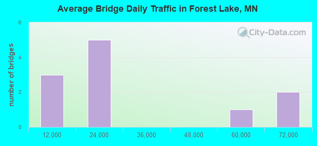
- 285,030Total average daily traffic
- 11,920Total average daily truck traffic
- National Bridge Inventory (NBI) Registered Bridges for Forest Lake
- No street view available for this location
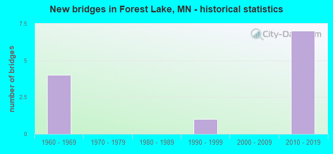
- New bridges - historical statistics
- 41960-1969
- 11990-1999
- 72010-2019
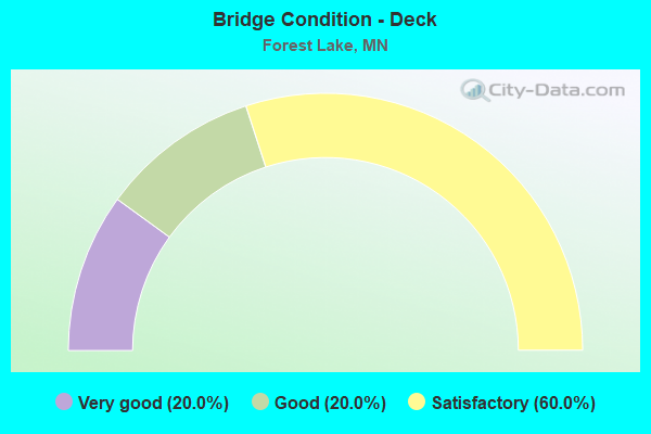
- Bridge Condition - Deck
- 20.0%Very good
- 20.0%Good
- 60.0%Satisfactory
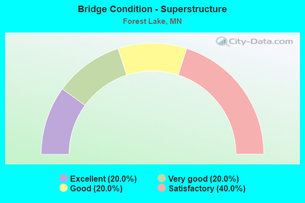
- Bridge Condition - Superstructure
- 20.0%Excellent
- 20.0%Very good
- 20.0%Good
- 40.0%Satisfactory
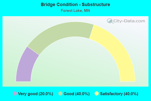
- Bridge Condition - Substructure
- 20.0%Very good
- 40.0%Good
- 40.0%Satisfactory
Find on map >> Show street view
Structure Number: 82001, Location: 0.1 MI W OF JCT TH 61 (Lat: 45.288803, Lng: -92.985817), Route carried "on" structure: US 8, Year Built: 1969, Status: Open, Structure Length: 7.34m (24.08ft), Average Daily Traffic: 22,600 (year 2019), Truck Traffic: 5%, Average Future Daily Traffic: 21,900 (year 2039), Design Load: HS 20, Features Intersected: 2nd St NW
Minimum Vertical Clearance: 30+ m (98+ ft), Kilometerpoint: 0.000, Lanes on structure: 4, Lanes under structure: 2, Base Highway Network: Yes, Owner: State Highway Agency, Approaching Roadway Width: 23.8m (78.1ft), Skew: 20 degrees, Material/Design: Prestressed concrete, Design/Construction: Stringer/Multi-beam, Number Of Spans In Main Unit: 4, Length of Maximum Span: 19.4m (63.6ft), Curb-To-Curb Width: 21.9m (71.9ft), Out-to-Out Width: 25.1m (82.3ft)
Condition: Deck: Satisfactory, Superstructure: Satisfactory, Substructure: Satisfactory, Operating Rating: 73.9 metric tons, Method Used To Determine Operating Rating: Load Factor (LF), Inventory Rating: 42.9 metric tons, Method Used To Determine Inventory Rating: Load Factor (LF), Structural Evaluation: Equal to present minimum criteria, Deck Geometry: Better than present minimum criteria, Underclear: Superior to present desirable criteria, Approach Roadway Alignment: Better than present minimum criteria, Designated Inspection Frequency: Every 24 months, Inspection Date: August 2021, Deck Structure Type: Concrete Cast-file-Place, Wearing Surface/Protective System: Wearing Surface: Low Slump Concrete
Find on map >> Show street view
Structure Number: 82002, Location: 1.0 MI E OF JCT TH 35 (Lat: 45.288978, Lng: -92.983978), Route carried "on" structure: US 8, Year Built: 1969, Status: Open, Structure Length: 8.88m (29.13ft), Average Daily Traffic: 22,600 (year 2019), Truck Traffic: 5%, Average Future Daily Traffic: 21,900 (year 2039), Design Load: HS 20, Features Intersected: TH 61
Minimum Vertical Clearance: 30+ m (98+ ft), Kilometerpoint: 0.000, Lanes on structure: 4, Lanes under structure: 4, Base Highway Network: Yes, Owner: State Highway Agency, Approaching Roadway Width: 23.8m (78.1ft), Skew: 20 degrees, Material/Design: Prestressed concrete, Design/Construction: Stringer/Multi-beam, Number Of Spans In Main Unit: 4, Length of Maximum Span: 25.0m (82.0ft), Curb-To-Curb Width: 21.9m (71.9ft), Out-to-Out Width: 25.1m (82.3ft)
Condition: Deck: Satisfactory, Superstructure: Satisfactory, Substructure: Satisfactory, Operating Rating: 73.7 metric tons, Method Used To Determine Operating Rating: Load Factor (LF), Inventory Rating: 22.4 metric tons, Method Used To Determine Inventory Rating: Load Factor (LF), Structural Evaluation: Somewhat better than minimum adequacy, Deck Geometry: Better than present minimum criteria, Underclear: Better than present minimum criteria, Approach Roadway Alignment: Equal to present desirable criteria, Designated Inspection Frequency: Every 24 months, Inspection Date: August 2021, Deck Structure Type: Concrete Cast-file-Place, Wearing Surface/Protective System: Wearing Surface: Low Slump Concrete
Find on map >> Show street view
Structure Number: 82527, Location: 0.5 MI S OF JCT TH 8 (Lat: 45.279444, Lng: -93.003381), Route carried "on" structure: County highway 2, Year Built: 2011, Status: Open, Structure Length: 7.67m (25.16ft), Average Daily Traffic: 23,300 (year 2019), Truck Traffic: 4%, Average Future Daily Traffic: 22,800 (year 2039), Design Load: HL 93, Features Intersected: I 35
Minimum Vertical Clearance: 30+ m (98+ ft), Kilometerpoint: 0.000, Lanes on structure: 7, Lanes under structure: 6, Owner: State Highway Agency, Approaching Roadway Width: 28.0m (91.9ft), Skew: 21 degrees, Material/Design: Prestressed concrete, Design/Construction: Stringer/Multi-beam, Number Of Spans In Main Unit: 2, Length of Maximum Span: 38.7m (127.0ft), Curb or Sidewalk Widths: Left: 1.8m (5.9ft), Right: 3.7m (12.1ft), Curb-To-Curb Width: 29.9m (98.1ft), Out-to-Out Width: 36.1m (118.4ft)
Condition: Deck: Satisfactory, Superstructure: Very good, Substructure: Good, Operating Rating: 99.2 metric tons, Method Used To Determine Operating Rating: Load Factor (LF), Inventory Rating: 54.9 metric tons, Method Used To Determine Inventory Rating: Load Factor (LF), Structural Evaluation: Better than present minimum criteria, Deck Geometry: Equal to present minimum criteria, Underclear: Meets minimum limits, Approach Roadway Alignment: Equal to present desirable criteria, Designated Inspection Frequency: Every 24 months, Inspection Date: May 2020, Deck Structure Type: Concrete Cast-file-Place, Wearing Surface/Protective System: Wearing Surface: Low Slump Concrete, Deck Protection: Epoxy Coated Reinforcing
Find on map >> Show street view
Structure Number: 82528, Location: 1.49 MI S OF JCT TH 8 (Lat: 45.268617, Lng: -93.008806), Route carried "on" structure: County highway 32, Year Built: 2010, Status: Open, Structure Length: 12.84m (42.13ft), Average Daily Traffic: 5,500 (year 2017), Average Future Daily Traffic: 5,500 (year 2039), Design Load: HL 93, Features Intersected: I 35
Minimum Vertical Clearance: 30+ m (98+ ft), Kilometerpoint: 0.000, Lanes on structure: 2, Lanes under structure: 7, Owner: County Highway Agency, Approaching Roadway Width: 13.4m (44.0ft), Skew: 2 degrees, Material/Design: Prestressed concrete, Design/Construction: Stringer/Multi-beam, Number Of Spans In Main Unit: 4, Length of Maximum Span: 33.2m (108.9ft), Curb or Sidewalk Widths: Left: 3.7m (12.1ft), Right: 0.0m, Curb-To-Curb Width: 13.4m (44.0ft), Out-to-Out Width: 16.2m (53.1ft)
Condition: Deck: Good, Superstructure: Good, Substructure: Good, Operating Rating: 60.0 metric tons, Method Used To Determine Operating Rating: Load Factor (LF), Inventory Rating: 35.9 metric tons, Method Used To Determine Inventory Rating: Load Factor (LF), Structural Evaluation: Better than present minimum criteria, Deck Geometry: Equal to present minimum criteria, Underclear: Somewhat better than minimum adequacy, Approach Roadway Alignment: Better than present minimum criteria, Designated Inspection Frequency: Every 24 months, Inspection Date: May 2020, Deck Structure Type: Concrete Cast-file-Place, Wearing Surface/Protective System: Wearing Surface: Low Slump Concrete, Deck Protection: Epoxy Coated Reinforcing
Find on map >> Show street view
Structure Number: 82871, Location: AT JCT TH 8 (Lat: 45.289950, Lng: -93.002947), Route carried "on" structure: US 8, Year Built: 2018, Status: Open, Structure Length: 5.52m (18.11ft), Average Daily Traffic: 20,400 (year 2012), Truck Traffic: 4%, Average Future Daily Traffic: 28,100 (year 2038), Design Load: HL 93, Features Intersected: I 35
Minimum Vertical Clearance: 30+ m (98+ ft), Kilometerpoint: 0.000, Lanes on structure: 2, Lanes under structure: 4, Base Highway Network: Yes, Owner: State Highway Agency, Approaching Roadway Width: 11.6m (38.1ft), Material/Design: Prestressed concrete, Design/Construction: Stringer/Multi-beam, Number Of Spans In Main Unit: 2, Length of Maximum Span: 30.9m (101.4ft), Curb-To-Curb Width: 11.6m (38.1ft), Out-to-Out Width: 12.5m (41.0ft)
Condition: Deck: Very good, Superstructure: Excellent, Substructure: Very good, Operating Rating: 65.4 metric tons, Method Used To Determine Operating Rating: Load and Resistance Factor Rating (LRFR) rating reported by rating factor(RF) method using HL-93 loadings, Inventory Rating: 36.9 metric tons, Method Used To Determine Inventory Rating: Load and Resistance Factor Rating (LRFR) rating reported by rating factor(RF) method using HL-93 loadings, Structural Evaluation: Equal to present desirable criteria, Deck Geometry: Equal to present minimum criteria, Underclear: Equal to present minimum criteria, Approach Roadway Alignment: Better than present minimum criteria, Designated Inspection Frequency: Every 24 months, Inspection Date: May 2020, Deck Structure Type: Concrete Cast-file-Place, Wearing Surface/Protective System: Wearing Surface: Monolithic Concrete, Deck Protection: Epoxy Coated Reinforcing
Find on map >> Show street view
Structure Number: 97418, Location: 1.4 MI S OF JCT CR 50 (Lat: 45.219028, Lng: -92.958839), Route carried "on" structure: City street 760, Year Built: 1992, Status: Open, Structure Length: 0.77m (2.53ft), Average Daily Traffic: 130 (year 2001), Average Future Daily Traffic: 114 (year 2029), Design Load: HS 20, Features Intersected: HARDWOOD CREEK
Minimum Vertical Clearance: 30+ m (98+ ft), Kilometerpoint: 0.000, Lanes on structure: 2, Owner: City or Municipal Highway Agency, Approaching Roadway Width: 9.1m (29.9ft), Material/Design: Concrete, Design/Construction: Culvert, Number Of Spans In Main Unit: 2, Length of Maximum Span: 2.9m (9.5ft)
Condition: Channel: Satisfactory, Culverts: Good, Operating Rating: 53.9 metric tons, Method Used To Determine Operating Rating: Assigned ratings based on Allowable Stress Design (ASD) reported in metric tons, Inventory Rating: 35.9 metric tons, Method Used To Determine Inventory Rating: Assigned ratings based on Allowable Stress Design (ASD) reported in metric tons, Structural Evaluation: Better than present minimum criteria, Waterway Adequacy: Better than present minimum criteria, Approach Roadway Alignment: Better than present minimum criteria, Designated Inspection Frequency: Every 24 months, Inspection Date: October 2021
Find on map >> Show street view
Structure Number: 82001, Location: 0.1 MI W OF JCT TH 61 (Lat: 45.288803, Lng: -92.985817), Route carried "under" structure: City street 18, Year Built: 1969, Structure Length: 0. m, Average Daily Traffic: 100 (year 1978), Features Intersected: 2nd St NW, Facility Carried by Structure: US 8
Minimum Vertical Clearance: 7.56m (24.80ft), Kilometerpoint: 0.000, Lanes on structure: 4, Lanes under structure: 2, Material/Design: Prestressed concrete, Design/Construction: Stringer/Multi-beam, Length of Maximum Span: 19.4m (63.6ft)
Find on map >> Show street view
Structure Number: 82002, Location: 1.0 MI E OF JCT TH 35 (Lat: 45.288978, Lng: -92.983978), Route carried "under" structure: US 61, Year Built: 1969, Structure Length: 0. m, Average Daily Traffic: 13,400 (year 2019), Truck Traffic: 3%, Features Intersected: TH 61, Facility Carried by Structure: US 8
Minimum Vertical Clearance: 7.47m (24.51ft), Kilometerpoint: 0.000, Lanes on structure: 4, Lanes under structure: 4, Material/Design: Prestressed concrete, Design/Construction: Stringer/Multi-beam, Length of Maximum Span: 25.0m (82.0ft)
Find on map >> Show street view
Structure Number: 82527, Location: 0.5 MI S OF JCT TH 8 (Lat: 45.279444, Lng: -93.003381), Route carried "under" structure: Interstate 35, Year Built: 2011, Structure Length: 0. m, Average Daily Traffic: 62,000 (year 2019), Truck Traffic: 5%, Features Intersected: I 35, Facility Carried by Structure: CSAH 2
Minimum Vertical Clearance: 5.00m (16.40ft), Kilometerpoint: 0.000, Lanes under structure: 6, Material/Design: Prestressed concrete, Design/Construction: Stringer/Multi-beam, Length of Maximum Span: 38.7m (127.0ft)
Find on map >> Show street view
Structure Number: 82528, Location: 1.49 MI S OF JCT TH 8 (Lat: 45.268617, Lng: -93.008806), Route carried "under" structure: Interstate 35, Year Built: 2010, Structure Length: 0. m, Average Daily Traffic: 67,000 (year 2019), Truck Traffic: 3%, Features Intersected: I 35, Facility Carried by Structure: CSAH 32
Minimum Vertical Clearance: 4.97m (16.31ft), Kilometerpoint: 0.000, Lanes under structure: 6, Material/Design: Prestressed concrete, Design/Construction: Stringer/Multi-beam, Length of Maximum Span: 33.2m (108.9ft)
Find on map >> Show street view
Structure Number: 82528, Location: 1.49 MI S OF JCT TH 8 (Lat: 45.268617, Lng: -93.008806), Route carried "under" structure: Ramp Interstate 68, Year Built: 2010, Structure Length: 0. m, Features Intersected: I 35, Facility Carried by Structure: CSAH 32
Minimum Vertical Clearance: 4.97m (16.31ft), Kilometerpoint: 0.000, Lanes under structure: 1, Material/Design: Prestressed concrete, Design/Construction: Stringer/Multi-beam, Length of Maximum Span: 33.2m (108.9ft)
Find on map >> Show street view
Structure Number: 82871, Location: AT JCT TH 8 (Lat: 45.289950, Lng: -93.002947), Route carried "under" structure: Interstate 35, Year Built: 2018, Structure Length: 0. m, Average Daily Traffic: 48,000 (year 2019), Truck Traffic: 5%, Features Intersected: I 35, Facility Carried by Structure: US 8
Minimum Vertical Clearance: 5.03m (16.50ft), Kilometerpoint: 0.000, Lanes under structure: 4, Material/Design: Prestressed concrete, Design/Construction: Stringer/Multi-beam, Length of Maximum Span: 30.9m (101.4ft)