Bridge Statistics for Fort Walton Beach, Florida (FL)
Condition, Traffic, Stress, Structural Evaluation, Project Costs
- National Bridge Inventory (NBI) Statistics
- 10Number of bridges
- 292ft / 89.4mTotal length
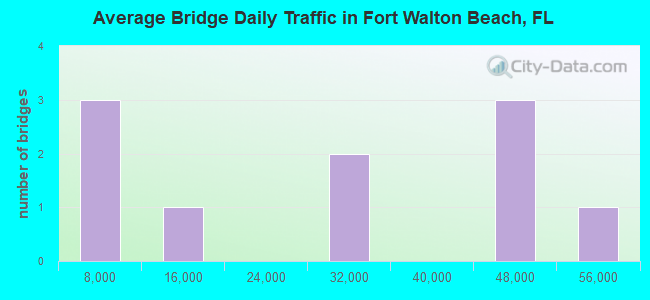
- 258,620Total average daily traffic
- 14,390Total average daily truck traffic
- National Bridge Inventory (NBI) Registered Bridges for Fort Walton Beach
- No street view available for this location
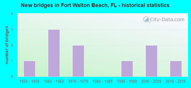
- New bridges - historical statistics
- 11950-1959
- 31960-1969
- 21970-1979
- 11990-1999
- 22000-2009
- 12010-2019
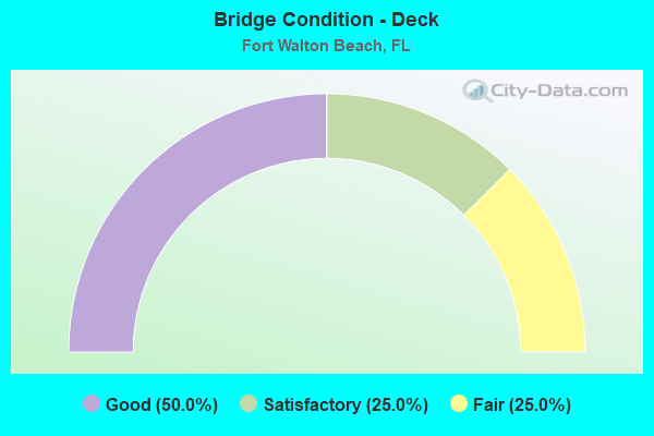
- Bridge Condition - Deck
- 50.0%Good
- 25.0%Satisfactory
- 25.0%Fair
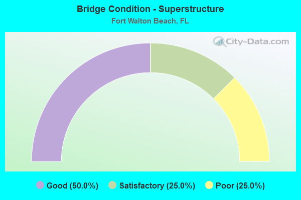
- Bridge Condition - Superstructure
- 50.0%Good
- 25.0%Satisfactory
- 25.0%Poor

- Bridge Condition - Substructure
- 50.0%Good
- 25.0%Satisfactory
- 25.0%Fair
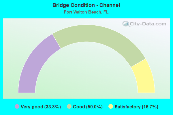
- Bridge Condition - Channel
- 33.3%Very good
- 50.0%Good
- 16.7%Satisfactory
Find on map >> Show street view
Structure Number: 570003, Location: 2.2Mi West of SR 85 (Lat: 30.477750, Lng: -86.596028), Route carried "on" structure: State highway 189, Year Built: 1971, Status: Open, Structure Length: 1.11m (3.64ft), Average Daily Traffic: 30,000 (year 2020), Truck Traffic: 7%, Average Future Daily Traffic: 52,050 (year 2042), Design Load: HS 20, Features Intersected: Lightwood Knot Creek
Minimum Vertical Clearance: 30+ m (98+ ft), Kilometerpoint: 5.473, Lanes on structure: 4, Owner: State Highway Agency, Approaching Roadway Width: 17.1m (56.1ft), Skew: 13 degrees, Material/Design: Concrete, Design/Construction: Culvert, Number Of Spans In Main Unit: 3, Length of Maximum Span: 3.5m (11.5ft)
Condition: Channel: Good, Culverts: Satisfactory, Structural Evaluation: Equal to present minimum criteria, Waterway Adequacy: Equal to present minimum criteria, Approach Roadway Alignment: Equal to present desirable criteria, Designated Inspection Frequency: Every 24 months, Underwater Inspection Frequency: Every 24 months, Inspection Date: May 2020, Underwater Inspection Date: May 2020
Find on map >> Show street view
Structure Number: 570018, Location: 3.5 miles North of US98 (Lat: 30.440428, Lng: -86.589775), Route carried "on" structure: State highway 85, Year Built: 1958, Year Reconstructed: 1988, Status: Open, Structure Length: 44.26m (145.21ft), Average Daily Traffic: 48,000 (year 2020), Truck Traffic: 5%, Average Future Daily Traffic: 83,280 (year 2042), Design Load: HS 20, Features Intersected: Garniers Bayou
Minimum Vertical Clearance: 30+ m (98+ ft), Kilometerpoint: 5.446, Lanes on structure: 6, Base Highway Network: Yes, Owner: State Highway Agency, Approaching Roadway Width: 27.4m (89.9ft), Skew: 30 degrees, Navigation Control: Yes ( Vertical Clearance: 5.9m (19.4ft), Horizontal Clearance: 19.1m (62.7ft)), Material/Design: Prestressed concrete, Design/Construction: Stringer/Multi-beam, Number Of Spans In Main Unit: 22, Length of Maximum Span: 20.1m (65.9ft), Curb or Sidewalk Widths: Left: 1.5m (4.9ft), Right: 1.5m (4.9ft), Curb-To-Curb Width: 25.6m (84.0ft), Out-to-Out Width: 30.8m (101.0ft)
Condition: Deck: Satisfactory, Superstructure: Satisfactory, Substructure: Satisfactory, Channel: Very good, Operating Rating: 84.4 metric tons, Method Used To Determine Operating Rating: Load Factor (LF), Inventory Rating: 49.9 metric tons, Method Used To Determine Inventory Rating: Load Factor (LF), Structural Evaluation: Equal to present minimum criteria, Deck Geometry: Somewhat better than minimum adequacy, Waterway Adequacy: Superior to present desirable criteria, Approach Roadway Alignment: Equal to present desirable criteria, Designated Inspection Frequency: Every 24 months, Underwater Inspection Frequency: Every 24 months, Inspection Date: March 2020, Underwater Inspection Date: March 2020, Deck Structure Type: Concrete Cast-file-Place, Wearing Surface/Protective System: Wearing Surface: Bituminous
Find on map >> Show street view
Structure Number: 570034, Location: 0.5mi. East of SR85 (Lat: 30.401092, Lng: -86.600561), Route carried "on" structure: US 98, Year Built: 1964, Status: Open, Structure Length: 40.17m (131.79ft), Average Daily Traffic: 46,000 (year 2020), Truck Traffic: 6%, Average Future Daily Traffic: 79,810 (year 2042), Design Load: HS 20+Mod, Features Intersected: ICWW & Brooks ST.
Minimum Vertical Clearance: 30+ m (98+ ft), Kilometerpoint: 19.066, Lanes on structure: 4, Lanes under structure: 4, Base Highway Network: Yes, Owner: State Highway Agency, Approaching Roadway Width: 19.5m (64.0ft), Skew: 20 degrees, Navigation Control: Yes ( Vertical Clearance: 15.2m (49.9ft), Horizontal Clearance: 42.7m (140.1ft)), Material/Design: Steel continuous, Design/Construction: Stringer/Multi-beam, Number Of Spans In Main Unit: 3, Number Of Approach Spans: 10, Length of Maximum Span: 61.0m (200.1ft), Curb or Sidewalk Widths: Left: 1.2m (3.9ft), Right: 1.2m (3.9ft), Curb-To-Curb Width: 17.1m (56.1ft), Out-to-Out Width: 21.4m (70.2ft)
Condition: Deck: Fair, Superstructure: Poor, Substructure: Fair, Channel: Good, Operating Rating: 69.6 metric tons, Method Used To Determine Operating Rating: Load Factor (LF), Inventory Rating: 41.7 metric tons, Method Used To Determine Inventory Rating: Load Factor (LF), Structural Evaluation: Meets minimum limits, Deck Geometry: Somewhat better than minimum adequacy, Underclear: Meets minimum limits, Waterway Adequacy: Superior to present desirable criteria, Approach Roadway Alignment: Equal to present desirable criteria, Designated Inspection Frequency: Every 24 months, Underwater Inspection Frequency: Every 24 months, Other Special Inspection Frequency: Every 12 months, Inspection Date: October 2021, Underwater Inspection Date: October 2021, Other Special Inspection Date: October 2021, Deck Structure Type: Concrete Cast-file-Place
Find on map >> Show street view
Structure Number: 570042, Location: 1.6 mi West of SR85 (Lat: 30.480556, Lng: -86.585472), Route carried "on" structure: State highway 189, Year Built: 1972, Status: Open, Structure Length: 0.96m (3.15ft), Average Daily Traffic: 30,000 (year 2020), Truck Traffic: 7%, Average Future Daily Traffic: 52,050 (year 2042), Design Load: HS 20, Features Intersected: Gariner Creek
Minimum Vertical Clearance: 30+ m (98+ ft), Kilometerpoint: 6.581, Lanes on structure: 4, Owner: State Highway Agency, Approaching Roadway Width: 17.1m (56.1ft), Skew: 10 degrees, Material/Design: Concrete, Design/Construction: Culvert, Number Of Spans In Main Unit: 3, Length of Maximum Span: 3.0m (9.8ft)
Condition: Channel: Satisfactory, Culverts: Satisfactory, Structural Evaluation: Equal to present minimum criteria, Waterway Adequacy: Somewhat better than minimum adequacy, Approach Roadway Alignment: Equal to present desirable criteria, Designated Inspection Frequency: Every 24 months, Underwater Inspection Frequency: Every 24 months, Inspection Date: April 2020, Underwater Inspection Date: April 2020
Find on map >> Show street view
Structure Number: 570171, Location: 3.1 Miles N. of US98 SR30 (Lat: 30.431944, Lng: -86.639500), Route carried "on" structure: State highway 189, Year Built: 2014, Status: Open, Structure Length: 1.07m (3.51ft), Average Daily Traffic: 47,500 (year 2020), Truck Traffic: 4%, Average Future Daily Traffic: 82,412 (year 2042), Design Load: HL 93, Features Intersected: Five Mile Bayou
Minimum Vertical Clearance: 30+ m (98+ ft), Kilometerpoint: 4.995, Lanes on structure: 4, Owner: State Highway Agency, Approaching Roadway Width: 9.1m (29.9ft), Skew: 20 degrees, Material/Design: Concrete, Design/Construction: Slab, Number Of Spans In Main Unit: 1, Length of Maximum Span: 10.7m (35.1ft), Curb or Sidewalk Widths: Left: 1.5m (4.9ft), Right: 1.5m (4.9ft), Curb-To-Curb Width: 18.3m (60.0ft), Out-to-Out Width: 28.5m (93.5ft)
Condition: Deck: Good, Superstructure: Good, Substructure: Good, Channel: Very good, Operating Rating: 62.7 metric tons, Method Used To Determine Operating Rating: Load and Resistance Factor (LRFR), Inventory Rating: 48.4 metric tons, Method Used To Determine Inventory Rating: Load and Resistance Factor (LRFR), Structural Evaluation: Better than present minimum criteria, Deck Geometry: Somewhat better than minimum adequacy, Waterway Adequacy: Equal to present desirable criteria, Approach Roadway Alignment: Equal to present desirable criteria, Designated Inspection Frequency: Every 24 months, Underwater Inspection Frequency: Every 24 months, Inspection Date: July 2020, Underwater Inspection Date: July 2020, Deck Structure Type: Concrete Cast-file-Place
Find on map >> Show street view
Structure Number: 574144, Location: 1.19 Mi North of US 98 (Lat: 30.418603, Lng: -86.596081), Route carried "on" structure: City street , Year Built: 2004, Status: Open, Structure Length: 1.83m (6.00ft), Average Daily Traffic: 1,400 (year 2019), Truck Traffic: 4%, Average Future Daily Traffic: 2,429 (year 2041), Design Load: HS 20, Features Intersected: Branch of Lake Earl, Facility Carried by Structure: Ferry Road N. E.
Minimum Vertical Clearance: 30+ m (98+ ft), Kilometerpoint: 1.717, Lanes on structure: 2, Owner: City or Municipal Highway Agency, Approaching Roadway Width: 10.4m (34.1ft), Material/Design: Concrete continuous, Design/Construction: Slab, Number Of Spans In Main Unit: 2, Length of Maximum Span: 9.1m (29.9ft), Curb or Sidewalk Widths: Left: 1.7m (5.6ft), Right: 1.7m (5.6ft), Curb-To-Curb Width: 10.4m (34.1ft), Out-to-Out Width: 14.9m (48.9ft)
Condition: Deck: Good, Superstructure: Good, Substructure: Good, Channel: Good, Operating Rating: 59.1 metric tons, Method Used To Determine Operating Rating: Load Factor (LF), Inventory Rating: 35.7 metric tons, Method Used To Determine Inventory Rating: Load Factor (LF), Structural Evaluation: Better than present minimum criteria, Deck Geometry: Equal to present minimum criteria, Waterway Adequacy: Equal to present desirable criteria, Approach Roadway Alignment: Equal to present desirable criteria, Designated Inspection Frequency: Every 24 months, Inspection Date: July 2020, Deck Structure Type: Concrete Cast-file-Place
Find on map >> Show street view
Structure Number: 570034, Location: 0.5mi. East of SR85 (Lat: 30.401092, Lng: -86.600561), Route carried "under" structure: Ramp City street , Year Built: 1964, Structure Length: 0. m, Average Daily Traffic: 560 (year 1999), Truck Traffic: 5%, Features Intersected: ICWW & Brooks ST., Facility Carried by Structure: US98 SR30
Minimum Vertical Clearance: 7.10m (23.29ft), Kilometerpoint: 0.000, Lanes on structure: 4, Lanes under structure: 2, Material/Design: Steel continuous, Design/Construction: Stringer/Multi-beam, Length of Maximum Span: 61.0m (200.1ft)
Find on map >> Show street view
Structure Number: 570034, Location: 0.5mi. East of SR85 (Lat: 30.401092, Lng: -86.600561), Route carried "under" structure: City street , Year Built: 1964, Structure Length: 0. m, Average Daily Traffic: 560 (year 1999), Truck Traffic: 5%, Features Intersected: ICWW & Brooks ST., Facility Carried by Structure: US98 SR30
Minimum Vertical Clearance: 4.80m (15.75ft), Kilometerpoint: 0.000, Lanes on structure: 4, Lanes under structure: 2, Material/Design: Steel continuous, Design/Construction: Stringer/Multi-beam, Length of Maximum Span: 61.0m (200.1ft)
Find on map >> Show street view
Structure Number: 579005, Location: 1.1 Miles East of SR85 (Lat: 30.395750, Lng: -86.587425), Route carried "under" structure: State highway 98, Year Built: 2007, Structure Length: 0. m, Average Daily Traffic: 46,000 (year 2020), Truck Traffic: 6%, Features Intersected: US98, Facility Carried by Structure: PedestrianOverpass
Minimum Vertical Clearance: 7.71m (25.30ft), Kilometerpoint: 21.074, Lanes under structure: 5, Material/Design: Steel, Design/Construction: Truss - Thru, Length of Maximum Span: 68.3m (224.1ft)
Find on map >> Show street view
Structure Number: 609005, Location: 0.9Mi West of US 90 (Lat: 30.375289, Lng: -86.366217), Route carried "under" structure: County highway 2378, Year Built: 1994, Structure Length: 0. m, Average Daily Traffic: 8,600 (year 2020), Truck Traffic: 3%, Features Intersected: Scenic Gulf Dr CR 2378, Facility Carried by Structure: Pedestrian Bridge
Minimum Vertical Clearance: 4.21m (13.81ft), Kilometerpoint: 3.040, Lanes under structure: 2, Material/Design: Prestressed concrete, Design/Construction: Stringer/Multi-beam, Length of Maximum Span: 40.8m (133.9ft)