Bridge Statistics for Foster City, California (CA)
Condition, Traffic, Stress, Structural Evaluation, Project Costs
- National Bridge Inventory (NBI) Statistics
- 12Number of bridges
- 3,907ft / 1,191mTotal length
- $344,910,000Total costs
- 462,548Total average daily traffic
- 30,613Total average daily truck traffic
- National Bridge Inventory (NBI) Registered Bridges for Foster City
- No street view available for this location
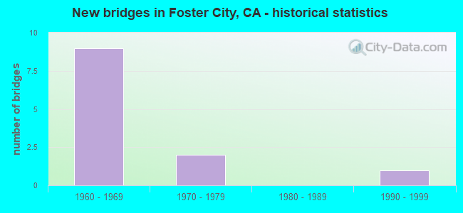
- New bridges - historical statistics
- 91960-1969
- 21970-1979
- 11990-1999
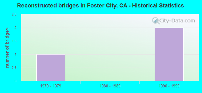
- Reconstructed bridges - Historical Statistics
- 11970-1979
- 01980-1989
- 21990-1999
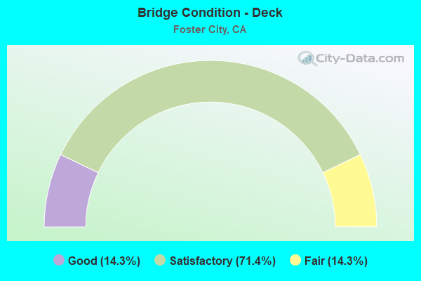
- Bridge Condition - Deck
- 14.3%Good
- 71.4%Satisfactory
- 14.3%Fair

- Bridge Condition - Superstructure
- 42.9%Good
- 57.1%Satisfactory
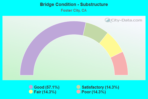
- Bridge Condition - Substructure
- 57.1%Good
- 14.3%Satisfactory
- 14.3%Fair
- 14.3%Poor
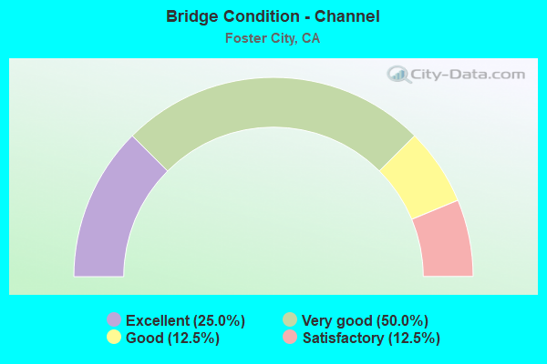
- Bridge Condition - Channel
- 25.0%Excellent
- 50.0%Very good
- 12.5%Good
- 12.5%Satisfactory
Find on map >> Show street view
Structure Number: 35 0054, Location: 04-SM-092-R14.44-FSTC (Lat: 37.573553, Lng: -122.262347), Route carried "on" structure: State highway 92, Year Built: 1967, Year Reconstructed: 2002, Status: Open, Structure Length: 1099.38m (3606.89ft), Average Daily Traffic: 120,000 (year 2019), Truck Traffic: 7%, Average Future Daily Traffic: 138,335 (year 2040), Design Load: HS 20, Features Intersected: SAN FRANCISCO BAY
Minimum Vertical Clearance: 30+ m (98+ ft), Kilometerpoint: 14.440, Lanes on structure: 6, Base Highway Network: Yes (, Subroute: 1), Toll: Toll bridge, Owner: State Highway Agency, Approaching Roadway Width: 42.1m (138.1ft), Skew: 30 degrees, Navigation Control: Yes ( Vertical Clearance: 41.1m (134.8ft), Horizontal Clearance: 152.4m (500.0ft)), Material/Design: Steel, Design/Construction: Orthotropic, Number Of Spans In Main Unit: 37, Number Of Approach Spans: 871, Length of Maximum Span: 228.6m (750.0ft), Curb or Sidewalk Widths: Left: 0.8m (2.6ft), Right: 0.8m (2.6ft), Curb-To-Curb Width: 22.5m (73.8ft), Out-to-Out Width: 25.9m (85.0ft)
Condition: Deck: Good, Superstructure: Good, Substructure: Poor, Channel: Very good, Operating Rating: 28.2 metric tons, Method Used To Determine Operating Rating: Load and Resistance Factor Rating (LRFR) rating reported by rating factor(RF) method using HL-93 loadings, Inventory Rating: 19.4 metric tons, Method Used To Determine Inventory Rating: Load and Resistance Factor Rating (LRFR) rating reported by rating factor(RF) method using HL-93 loadings, Structural Evaluation: Meets minimum limits, Deck Geometry: Meets minimum limits, Waterway Adequacy: Equal to present desirable criteria, Approach Roadway Alignment: Equal to present desirable criteria, Length Of Structure Improvement: 1099.38m (3606.89ft), Designated Inspection Frequency: Every 24 months, Critical Feature Inspection Frequency: Every 24 months, Underwater Inspection Frequency: Every 60 months, Inspection Date: December 2020, Critical Feature Inspection Date: October 2020, Underwater Inspection Date: September 2019, Bridge Improvement Cost: $205,304,000, Roadway Improvement Cost: $41,060,000, Total Project Cost: $344,910,000 ( Estimate for 2017), Deck Structure Type: Steel plate, Wearing Surface/Protective System: Wearing Surface: Bituminous, Deck Protection: Bituminous
Find on map >> Show street view
Structure Number: 35 0189, Location: 04-SM-092-R13.83-FSTC (Lat: 37.566119, Lng: -122.270336), Route carried "on" structure: State highway 92, Year Built: 1967, Year Reconstructed: 1996, Status: Open, Structure Length: 15.88m (52.10ft), Average Daily Traffic: 86,000 (year 2009), Truck Traffic: 7%, Average Future Daily Traffic: 141,595 (year 2040), Design Load: HS 20, Features Intersected: FOSTER CITY LAGOON
Minimum Vertical Clearance: 30+ m (98+ ft), Kilometerpoint: 13.830, Lanes on structure: 8, Base Highway Network: Yes (, Subroute: 1), Owner: State Highway Agency, Approaching Roadway Width: 41.5m (136.2ft), Skew: 30 degrees, Material/Design: Concrete continuous, Design/Construction: Slab, Number Of Spans In Main Unit: 18, Length of Maximum Span: 15.8m (51.8ft), Curb-To-Curb Width: 41.5m (136.2ft), Out-to-Out Width: 43.1m (141.4ft)
Condition: Deck: Satisfactory, Superstructure: Good, Substructure: Good, Channel: Very good, Operating Rating: 54.1 metric tons, Method Used To Determine Operating Rating: Assigned rating based on Load Factor Design (LFD) reported in metric tons, Inventory Rating: 32.4 metric tons, Method Used To Determine Inventory Rating: Assigned rating based on Load Factor Design (LFD) reported in metric tons, Structural Evaluation: Better than present minimum criteria, Deck Geometry: Superior to present desirable criteria, Waterway Adequacy: Superior to present desirable criteria, Approach Roadway Alignment: Equal to present desirable criteria, Designated Inspection Frequency: Every 48 months, Underwater Inspection Frequency: Every 60 months, Inspection Date: August 2018, Underwater Inspection Date: July 2020, Deck Structure Type: Concrete Cast-file-Place
Find on map >> Show street view
Structure Number: 35C0061, Location: POLHEMUS ROAD (Lat: 37.534069, Lng: -122.350231), Route carried "on" structure: County highway , Year Built: 1974, Status: Open, Structure Length: 0.76m (2.49ft), Average Daily Traffic: 1,637 (year 2019), Truck Traffic: 2%, Average Future Daily Traffic: 3,081 (year 2039), Features Intersected: SAN MATEO CREEK, Facility Carried by Structure: CRYSTAL SPRINGS RD
Minimum Vertical Clearance: 30+ m (98+ ft), Kilometerpoint: 0.000, Lanes on structure: 2, Owner: County Highway Agency, Approaching Roadway Width: 15.2m (49.9ft), Material/Design: Concrete continuous, Design/Construction: Culvert, Number Of Spans In Main Unit: 2, Length of Maximum Span: 3.7m (12.1ft), Curb-To-Curb Width: 15.8m (51.8ft), Out-to-Out Width: 24.1m (79.1ft)
Condition: Channel: Good, Culverts: Satisfactory, Operating Rating: 54.1 metric tons, Method Used To Determine Operating Rating: Field evaluation and documented engineering judgment, Inventory Rating: 32.4 metric tons, Method Used To Determine Inventory Rating: Field evaluation and documented engineering judgment, Structural Evaluation: Equal to present minimum criteria, Deck Geometry: Superior to present desirable criteria, Waterway Adequacy: Better than present minimum criteria, Approach Roadway Alignment: Equal to present minimum criteria, Designated Inspection Frequency: Every 48 months, Inspection Date: May 2021
Find on map >> Show street view
Structure Number: 35C0062, Location: 0.1 MI E EDGEWATER BLVD (Lat: 37.546036, Lng: -122.271289), Route carried "on" structure: City street , Year Built: 1975, Status: Open, Structure Length: 22.86m (75.00ft), Average Daily Traffic: 12,800 (year 2013), Truck Traffic: 3%, Average Future Daily Traffic: 8,550 (year 2041), Design Load: HS 20, Features Intersected: FOSTER CITY LAGOON, Facility Carried by Structure: BEACH PARK BLVD
Minimum Vertical Clearance: 30+ m (98+ ft), Kilometerpoint: 0.000, Lanes on structure: 4, Owner: City or Municipal Highway Agency, Approaching Roadway Width: 10.1m (33.1ft), Skew: 10 degrees, Material/Design: Concrete continuous, Design/Construction: Box Beam or Girders - Multiple, Number Of Spans In Main Unit: 7, Number Of Approach Spans: 2, Length of Maximum Span: 30.5m (100.1ft), Curb or Sidewalk Widths: Left: 1.8m (5.9ft), Right: 1.8m (5.9ft), Curb-To-Curb Width: 20.3m (66.6ft), Out-to-Out Width: 21.8m (71.5ft)
Condition: Deck: Fair, Superstructure: Satisfactory, Substructure: Fair, Channel: Very good, Operating Rating: 95.6 metric tons, Method Used To Determine Operating Rating: Load Factor (LF), Inventory Rating: 57.3 metric tons, Method Used To Determine Inventory Rating: Load Factor (LF), Structural Evaluation: Somewhat better than minimum adequacy, Deck Geometry: Equal to present desirable criteria, Waterway Adequacy: Superior to present desirable criteria, Approach Roadway Alignment: Equal to present desirable criteria, Designated Inspection Frequency: Every 24 months, Underwater Inspection Frequency: Every 60 months, Inspection Date: April 2021, Underwater Inspection Date: July 2020, Deck Structure Type: Concrete Cast-file-Place
Find on map >> Show street view
Structure Number: 35C0069, Location: .6 MI N/O FOSTER CITY BLV (Lat: 37.565419, Lng: -122.267861), Route carried "on" structure: City street , Year Built: 1964, Year Reconstructed: 1983, Status: Open, Structure Length: 6.49m (21.29ft), Average Daily Traffic: 13,918 (year 2010), Truck Traffic: 15%, Average Future Daily Traffic: 16,356 (year 2041), Design Load: HS 20, Features Intersected: FOSTER CITY LAGOON, Facility Carried by Structure: HILLSDALE BLVD
Minimum Vertical Clearance: 30+ m (98+ ft), Kilometerpoint: 0.000, Lanes on structure: 4, Base Highway Network: Yes, Owner: City or Municipal Highway Agency, Approaching Roadway Width: 17.0m (55.8ft), Skew: 20 degrees, Material/Design: Prestressed concrete, Design/Construction: Stringer/Multi-beam, Number Of Spans In Main Unit: 5, Length of Maximum Span: 17.4m (57.1ft), Curb or Sidewalk Widths: Left: 2.0m (6.6ft), Right: 2.0m (6.6ft), Curb-To-Curb Width: 17.0m (55.8ft), Out-to-Out Width: 21.6m (70.9ft)
Condition: Deck: Satisfactory, Superstructure: Good, Substructure: Satisfactory, Channel: Satisfactory, Operating Rating: 83.9 metric tons, Method Used To Determine Operating Rating: Load Factor (LF), Inventory Rating: 32.4 metric tons, Method Used To Determine Inventory Rating: Load Factor (LF), Structural Evaluation: Equal to present minimum criteria, Deck Geometry: Somewhat better than minimum adequacy, Waterway Adequacy: Equal to present desirable criteria, Approach Roadway Alignment: Equal to present minimum criteria, Designated Inspection Frequency: Every 24 months, Underwater Inspection Frequency: Every 60 months, Inspection Date: April 2021, Underwater Inspection Date: July 2020, Deck Structure Type: Concrete Cast-file-Place
Find on map >> Show street view
Structure Number: 35C0070R, Location: EAST OF BOUNTY DRIVE (Lat: 37.555300, Lng: -122.258144), Route carried "on" structure: City street , Year Built: 1966, Status: Open, Structure Length: 15.36m (50.39ft), Average Daily Traffic: 6,943 (year 2010), Truck Traffic: 10%, Average Future Daily Traffic: 8,550 (year 2041), Design Load: HS 20, Features Intersected: FOSTER CITY LAGOON, Facility Carried by Structure: FOSTER CITY BLVD
Minimum Vertical Clearance: 30+ m (98+ ft), Kilometerpoint: 0.000, Lanes on structure: 2, Base Highway Network: Yes, Owner: City or Municipal Highway Agency, Approaching Roadway Width: 8.6m (28.2ft), Material/Design: Concrete continuous, Design/Construction: Box Beam or Girders - Multiple, Number Of Spans In Main Unit: 7, Length of Maximum Span: 30.5m (100.1ft), Curb or Sidewalk Widths: Left: 0.2m (0.7ft), Right: 0.2m (0.7ft), Curb-To-Curb Width: 8.6m (28.2ft), Out-to-Out Width: 9.8m (32.2ft)
Condition: Deck: Satisfactory, Superstructure: Satisfactory, Substructure: Good, Channel: Very good, Operating Rating: 55.4 metric tons, Method Used To Determine Operating Rating: Load and Resistance Factor Rating (LRFR) rating reported by rating factor(RF) method using HL-93 loadings, Inventory Rating: 40.8 metric tons, Method Used To Determine Inventory Rating: Load and Resistance Factor Rating (LRFR) rating reported by rating factor(RF) method using HL-93 loadings, Structural Evaluation: Equal to present minimum criteria, Deck Geometry: High priority of corrective action, Waterway Adequacy: Equal to present desirable criteria, Approach Roadway Alignment: Equal to present desirable criteria, Designated Inspection Frequency: Every 24 months, Underwater Inspection Frequency: Every 60 months, Inspection Date: April 2021, Underwater Inspection Date: July 2020, Deck Structure Type: Concrete Cast-file-Place
Find on map >> Show street view
Structure Number: 35C0071L, Location: .3 MI N/O BEACH PARK ROAD (Lat: 37.553061, Lng: -122.263950), Route carried "on" structure: City street , Year Built: 1966, Status: Open, Structure Length: 15.36m (50.39ft), Average Daily Traffic: 3,500 (year 2010), Truck Traffic: 10%, Average Future Daily Traffic: 7,749 (year 2039), Design Load: HS 20, Features Intersected: FOSTER CITY LAGOON, Facility Carried by Structure: SHELL BLVD
Minimum Vertical Clearance: 30+ m (98+ ft), Kilometerpoint: 0.000, Lanes on structure: 2, Owner: City or Municipal Highway Agency, Approaching Roadway Width: 8.5m (27.9ft), Material/Design: Concrete continuous, Design/Construction: Box Beam or Girders - Multiple, Number Of Spans In Main Unit: 5, Length of Maximum Span: 30.5m (100.1ft), Curb or Sidewalk Widths: Left: 0.3m (1.0ft), Right: 0.3m (1.0ft), Curb-To-Curb Width: 8.5m (27.9ft), Out-to-Out Width: 9.8m (32.2ft)
Condition: Deck: Satisfactory, Superstructure: Satisfactory, Substructure: Good, Channel: Excellent, Operating Rating: 55.4 metric tons, Method Used To Determine Operating Rating: Load and Resistance Factor Rating (LRFR) rating reported by rating factor(RF) method using HL-93 loadings, Inventory Rating: 40.8 metric tons, Method Used To Determine Inventory Rating: Load and Resistance Factor Rating (LRFR) rating reported by rating factor(RF) method using HL-93 loadings, Structural Evaluation: Equal to present minimum criteria, Deck Geometry: High priority of corrective action, Waterway Adequacy: Equal to present desirable criteria, Approach Roadway Alignment: Equal to present desirable criteria, Designated Inspection Frequency: Every 24 months, Underwater Inspection Frequency: Every 60 months, Inspection Date: April 2021, Underwater Inspection Date: July 2020, Deck Structure Type: Concrete Cast-file-Place, Wearing Surface/Protective System: Wearing Surface: Integral Concrete
Find on map >> Show street view
Structure Number: 35C0071R, Location: .3 MI N/O BEACH PARK ROAD (Lat: 37.553114, Lng: -122.263789), Route carried "on" structure: City street , Year Built: 1966, Status: Open, Structure Length: 15.36m (50.39ft), Average Daily Traffic: 3,500 (year 2010), Truck Traffic: 10%, Average Future Daily Traffic: 4,362 (year 2041), Design Load: HS 20, Features Intersected: FOSTER CITY LAGOON, Facility Carried by Structure: SHELL BLVD
Minimum Vertical Clearance: 30+ m (98+ ft), Kilometerpoint: 0.000, Lanes on structure: 2, Owner: City or Municipal Highway Agency, Approaching Roadway Width: 8.5m (27.9ft), Material/Design: Concrete continuous, Design/Construction: Box Beam or Girders - Multiple, Number Of Spans In Main Unit: 7, Length of Maximum Span: 30.5m (100.1ft), Curb or Sidewalk Widths: Left: 0.2m (0.7ft), Right: 0.2m (0.7ft), Curb-To-Curb Width: 8.5m (27.9ft), Out-to-Out Width: 9.8m (32.2ft)
Condition: Deck: Satisfactory, Superstructure: Satisfactory, Substructure: Good, Channel: Excellent, Operating Rating: 55.4 metric tons, Method Used To Determine Operating Rating: Load and Resistance Factor Rating (LRFR) rating reported by rating factor(RF) method using HL-93 loadings, Inventory Rating: 40.8 metric tons, Method Used To Determine Inventory Rating: Load and Resistance Factor Rating (LRFR) rating reported by rating factor(RF) method using HL-93 loadings, Structural Evaluation: Equal to present minimum criteria, Deck Geometry: High priority of corrective action, Waterway Adequacy: Equal to present desirable criteria, Approach Roadway Alignment: Equal to present desirable criteria, Designated Inspection Frequency: Every 24 months, Underwater Inspection Frequency: Every 60 months, Inspection Date: April 2021, Underwater Inspection Date: July 2020, Deck Structure Type: Concrete Cast-file-Place
Find on map >> Show street view
Structure Number: 35 0191, Location: 04-SM-092-R13.61-FSTC (Lat: 37.564381, Lng: -122.274528), Route carried "under" structure: Ramp State highway 92, Year Built: 1967, Structure Length: 0. m, Average Daily Traffic: 4,550 (year 2003), Truck Traffic: 2%, Features Intersected: STATE ROUTE 92, Facility Carried by Structure: FOSTER CITY BLVD
Minimum Vertical Clearance: 4.97m (16.31ft), Kilometerpoint: 13.610, Lanes on structure: 6, Lanes under structure: 1, Material/Design: Prestressed concrete, Design/Construction: Stringer/Multi-beam, Length of Maximum Span: 18.9m (62.0ft)
Find on map >> Show street view
Structure Number: 35 0191, Location: 04-SM-092-R13.61-FSTC (Lat: 37.564381, Lng: -122.274528), Route carried "under" structure: State highway 92, Year Built: 1967, Structure Length: 0. m, Average Daily Traffic: 86,000 (year 2009), Truck Traffic: 7%, Features Intersected: STATE ROUTE 92, Facility Carried by Structure: FOSTER CITY BLVD
Minimum Vertical Clearance: 4.98m (16.34ft), Kilometerpoint: 13.610, Lanes on structure: 6, Lanes under structure: 6, Material/Design: Prestressed concrete, Design/Construction: Stringer/Multi-beam, Length of Maximum Span: 18.9m (62.0ft)
Find on map >> Show street view
Structure Number: 35 0191, Location: 04-SM-092-R13.61-FSTC (Lat: 37.564381, Lng: -122.274528), Route carried "under" structure: Ramp State highway 92, Year Built: 1967, Structure Length: 0. m, Average Daily Traffic: 18,700 (year 2003), Truck Traffic: 5%, Features Intersected: STATE ROUTE 92, Facility Carried by Structure: FOSTER CITY BLVD
Minimum Vertical Clearance: 4.90m (16.08ft), Kilometerpoint: 13.610, Lanes on structure: 6, Lanes under structure: 1, Material/Design: Prestressed concrete, Design/Construction: Stringer/Multi-beam, Length of Maximum Span: 18.9m (62.0ft)
Find on map >> Show street view
Structure Number: 35 0313, Location: 04-SM-092-R13.25-FSTC (Lat: 37.561872, Lng: -122.278558), Route carried "under" structure: State highway 92, Year Built: 1991, Structure Length: 0. m, Average Daily Traffic: 105,000 (year 2009), Truck Traffic: 5%, Features Intersected: STATE ROUTE 92, Facility Carried by Structure: VINTAGE PARK DRIVE
Minimum Vertical Clearance: 4.90m (16.08ft), Kilometerpoint: 13.250, Lanes on structure: 4, Lanes under structure: 8, Material/Design: Prestressed concrete continuous, Design/Construction: Box Beam or Girders - Multiple, Length of Maximum Span: 33.5m (109.9ft)