Bridge Statistics for Geneva, Pennsylvania (PA)
Condition, Traffic, Stress, Structural Evaluation, Project Costs
- National Bridge Inventory (NBI) Statistics
- 16Number of bridges
- 830ft / 253mTotal length
- $3,663,000Total costs
- 49,934Total average daily traffic
- 14,264Total average daily truck traffic
- National Bridge Inventory (NBI) Registered Bridges for Geneva
- No street view available for this location
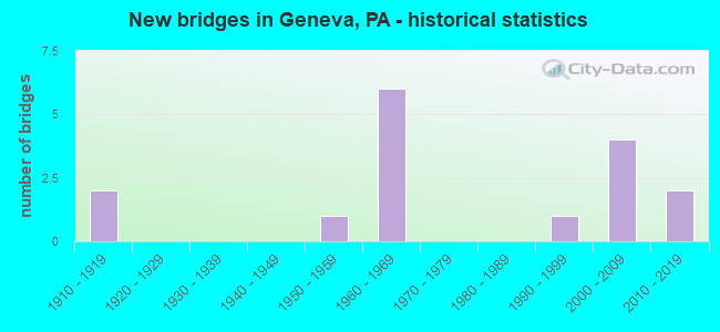
- New bridges - historical statistics
- 21910-1919
- 11950-1959
- 61960-1969
- 11990-1999
- 42000-2009
- 22010-2019
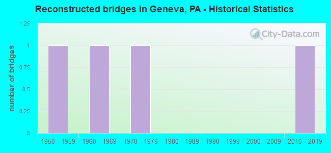
- Reconstructed bridges - Historical Statistics
- 11950-1959
- 11960-1969
- 11970-1979
- 01980-1989
- 01990-1999
- 02000-2009
- 12010-2019

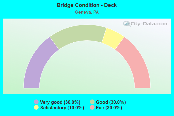
- Bridge Condition - Deck
- 30.0%Very good
- 30.0%Good
- 10.0%Satisfactory
- 30.0%Fair
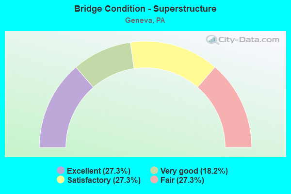
- Bridge Condition - Superstructure
- 27.3%Excellent
- 18.2%Very good
- 27.3%Satisfactory
- 27.3%Fair
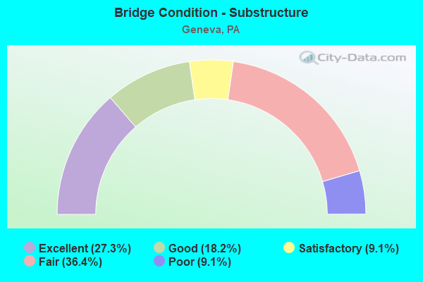
- Bridge Condition - Substructure
- 27.3%Excellent
- 18.2%Good
- 9.1%Satisfactory
- 36.4%Fair
- 9.1%Poor
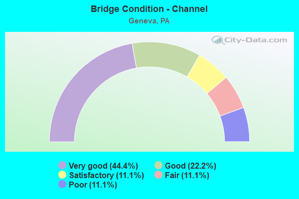
- Bridge Condition - Channel
- 44.4%Very good
- 22.2%Good
- 11.1%Satisfactory
- 11.1%Fair
- 11.1%Poor
Find on map >> Show street view
Structure Number: 12985, Location: GREENWOOD TOWNSHIP (Lat: 41.541861, Lng: -80.183608), Route carried "on" structure: Interstate 79, Year Built: 1969, Year Reconstructed: 1971, Status: Open, Structure Length: 109.73m (360.01ft), Average Daily Traffic: 6,732 (year 2021), Truck Traffic: 29%, Average Future Daily Traffic: 9,924 (year 2032), Design Load: HS 20+Mod, Features Intersected: OVER CONNEAUT SWAMP
Minimum Vertical Clearance: 30+ m (98+ ft), Kilometerpoint: 7.199, Lanes on structure: 2, Base Highway Network: Yes, Owner: State Highway Agency, Approaching Roadway Width: 7.3m (24.0ft), Skew: 10 degrees, Material/Design: Prestressed concrete, Design/Construction: Box Beam or Girders - Single/Spread, Number Of Spans In Main Unit: 60, Length of Maximum Span: 18.3m (60.0ft), Curb or Sidewalk Widths: Left: 0.2m (0.7ft), Right: 0.2m (0.7ft), Curb-To-Curb Width: 11.9m (39.0ft), Out-to-Out Width: 13.4m (44.0ft)
Condition: Deck: Good, Superstructure: Satisfactory, Substructure: Fair, Channel: Very good, Operating Rating: 85.3 metric tons, Method Used To Determine Operating Rating: Load Factor (LF), Inventory Rating: 16.3 metric tons, Method Used To Determine Inventory Rating: Load Factor (LF), Structural Evaluation: Meets minimum limits, Deck Geometry: Equal to present minimum criteria, Waterway Adequacy: Superior to present desirable criteria, Approach Roadway Alignment: Equal to present desirable criteria, Length Of Structure Improvement: 111.40m (365.49ft), Designated Inspection Frequency: Every 24 months, Underwater Inspection Frequency: Every 60 months, Inspection Date: June 2021, Underwater Inspection Date: May 2021, Deck Structure Type: Concrete Cast-file-Place, Wearing Surface/Protective System: Wearing Surface: Bituminous, Membrane: Preformed Fabric
Find on map >> Show street view
Structure Number: 12986, Location: GREENWOOD TOWNSHIP (Lat: 41.541750, Lng: -80.183836), Route carried "on" structure: Interstate 79, Year Built: 1969, Year Reconstructed: 1977, Status: Open, Structure Length: 109.73m (360.01ft), Average Daily Traffic: 6,999 (year 2021), Truck Traffic: 36%, Average Future Daily Traffic: 11,306 (year 2032), Design Load: HS 20+Mod, Features Intersected: OVER CONNEAUT SWAMP
Minimum Vertical Clearance: 30+ m (98+ ft), Kilometerpoint: 7.207, Lanes on structure: 2, Base Highway Network: Yes, Owner: State Highway Agency, Approaching Roadway Width: 11.9m (39.0ft), Skew: 10 degrees, Material/Design: Prestressed concrete, Design/Construction: Box Beam or Girders - Single/Spread, Number Of Spans In Main Unit: 60, Length of Maximum Span: 18.3m (60.0ft), Curb or Sidewalk Widths: Left: 0.2m (0.7ft), Right: 0.2m (0.7ft), Curb-To-Curb Width: 11.9m (39.0ft), Out-to-Out Width: 13.4m (44.0ft)
Condition: Deck: Fair, Superstructure: Satisfactory, Substructure: Fair, Channel: Very good, Operating Rating: 56.2 metric tons, Method Used To Determine Operating Rating: Load Factor (LF), Inventory Rating: 26.3 metric tons, Method Used To Determine Inventory Rating: Load Factor (LF), Structural Evaluation: Somewhat better than minimum adequacy, Deck Geometry: Equal to present minimum criteria, Waterway Adequacy: Superior to present desirable criteria, Approach Roadway Alignment: Equal to present desirable criteria, Length Of Structure Improvement: 111.40m (365.49ft), Designated Inspection Frequency: Every 24 months, Underwater Inspection Frequency: Every 60 months, Inspection Date: June 2021, Underwater Inspection Date: May 2021, Deck Structure Type: Concrete Cast-file-Place, Wearing Surface/Protective System: Wearing Surface: Bituminous, Membrane: Preformed Fabric
Find on map >> Show street view
Structure Number: 13091, Location: GREENWOOD TOWNSHIP (Lat: 41.539417, Lng: -80.184056), Route carried "on" structure: State highway 285, Year Built: 1969, Status: Open, Structure Length: 10.61m (34.81ft), Average Daily Traffic: 2,150 (year 2022), Truck Traffic: 13%, Average Future Daily Traffic: 2,288 (year 2032), Design Load: HS 20, Features Intersected: OVER SR 79,NB/SB
Minimum Vertical Clearance: 30+ m (98+ ft), Kilometerpoint: 30.761, Lanes on structure: 4, Lanes under structure: 12, Base Highway Network: Yes, Owner: State Highway Agency, Approaching Roadway Width: 18.6m (61.0ft), Skew: 33 degrees, Material/Design: Prestressed concrete, Design/Construction: Stringer/Multi-beam, Number Of Spans In Main Unit: 5, Length of Maximum Span: 29.3m (96.1ft), Curb or Sidewalk Widths: Left: 0.2m (0.7ft), Right: 0.2m (0.7ft), Curb-To-Curb Width: 18.4m (60.4ft), Out-to-Out Width: 19.7m (64.6ft)
Condition: Deck: Satisfactory, Superstructure: Satisfactory, Substructure: Satisfactory, Operating Rating: 56.2 metric tons, Method Used To Determine Operating Rating: Load Factor (LF), Inventory Rating: 22.7 metric tons, Method Used To Determine Inventory Rating: Load Factor (LF), Structural Evaluation: Equal to present minimum criteria, Deck Geometry: Somewhat better than minimum adequacy, Underclear: Better than present minimum criteria, Approach Roadway Alignment: Better than present minimum criteria, Length Of Structure Improvement: 10.60m (34.78ft), Designated Inspection Frequency: Every 24 months, Inspection Date: May 2021, Bridge Improvement Cost: $161,000, Roadway Improvement Cost: $474,000, Total Project Cost: $2,174,000, Deck Structure Type: Concrete Cast-file-Place, Wearing Surface/Protective System: Wearing Surface: Bituminous, Membrane: Other
Find on map >> Show street view
Structure Number: 13321, Location: UNION TOWNSHIP (Lat: 41.574719, Lng: -80.218731), Route carried "on" structure: State highway , Year Built: 1910, Year Reconstructed: 1962, Status: Open, Structure Length: 1.95m (6.40ft), Average Daily Traffic: 436 (year 2017), Truck Traffic: 13%, Average Future Daily Traffic: 426 (year 2032), Design Load: H 20, Features Intersected: OVER OUTLET CREEK, Facility Carried by Structure: SR 3021,KRIDER RD
Minimum Vertical Clearance: 30+ m (98+ ft), Kilometerpoint: 1.164, Lanes on structure: 2, Owner: State Highway Agency, Approaching Roadway Width: 6.4m (21.0ft), Material/Design: Steel, Design/Construction: Stringer/Multi-beam, Number Of Spans In Main Unit: 1, Length of Maximum Span: 18.9m (62.0ft), Curb or Sidewalk Widths: Left: 0.2m (0.7ft), Right: 0.2m (0.7ft), Curb-To-Curb Width: 7.3m (24.0ft), Out-to-Out Width: 8.1m (26.6ft)
Condition: Deck: Fair, Superstructure: Fair, Substructure: Fair, Channel: Good, Operating Rating: 89.8 metric tons, Method Used To Determine Operating Rating: Load Factor (LF), Inventory Rating: 58.1 metric tons, Method Used To Determine Inventory Rating: Load Factor (LF), Structural Evaluation: Somewhat better than minimum adequacy, Deck Geometry: Meets minimum limits, Waterway Adequacy: Equal to present desirable criteria, Approach Roadway Alignment: Better than present minimum criteria, Length Of Structure Improvement: 2.70m (8.86ft), Designated Inspection Frequency: Every 24 months, Inspection Date: May 2020, Deck Structure Type: Closed Grating, Wearing Surface/Protective System: Wearing Surface: Bituminous, Membrane: Preformed Fabric
Find on map >> Show street view
Structure Number: 13323, Location: VERNON TOWNSHIP (Lat: 41.589806, Lng: -80.219975), Route carried "on" structure: State highway , Year Built: 1953, Status: Open, Structure Length: 1.62m (5.31ft), Average Daily Traffic: 187 (year 2020), Truck Traffic: 7%, Average Future Daily Traffic: 257 (year 2032), Design Load: H 20, Features Intersected: OVER WATSON RUN, Facility Carried by Structure: SR 3023,WATSON RUN
Minimum Vertical Clearance: 30+ m (98+ ft), Kilometerpoint: 0.021, Lanes on structure: 2, Owner: State Highway Agency, Approaching Roadway Width: 4.9m (16.1ft), Skew: 1 degrees, Material/Design: Steel, Design/Construction: Stringer/Multi-beam, Number Of Spans In Main Unit: 1, Length of Maximum Span: 15.2m (49.9ft), Curb or Sidewalk Widths: Left: 0.2m (0.7ft), Right: 0.2m (0.7ft), Curb-To-Curb Width: 6.9m (22.6ft), Out-to-Out Width: 7.7m (25.3ft)
Condition: Deck: Fair, Superstructure: Fair, Substructure: Fair, Channel: Fair, Operating Rating: 59.0 metric tons, Method Used To Determine Operating Rating: Load Factor (LF), Inventory Rating: 35.4 metric tons, Method Used To Determine Inventory Rating: Load Factor (LF), Structural Evaluation: Somewhat better than minimum adequacy, Deck Geometry: Meets minimum limits, Waterway Adequacy: Better than present minimum criteria, Approach Roadway Alignment: Equal to present desirable criteria, Length Of Structure Improvement: 2.30m (7.55ft), Designated Inspection Frequency: Every 24 months, Inspection Date: April 2021, Deck Structure Type: Closed Grating, Wearing Surface/Protective System: Wearing Surface: Bituminous
Find on map >> Show street view
Structure Number: 13504, Location: 1 MI.S.SR-0006 ON T-488 (Lat: 41.602322, Lng: -80.224439), Route carried "on" structure: City street 7230, Year Built: 1960, Year Reconstructed: 2015, Status: Open, Structure Length: 1.86m (6.10ft), Average Daily Traffic: 400 (year 2021), Average Future Daily Traffic: 500 (year 2041), Design Load: HL 93, Features Intersected: OVER WATSON RUN, Facility Carried by Structure: T-488,HOLLIS ROAD
Minimum Vertical Clearance: 30+ m (98+ ft), Kilometerpoint: 0.000, Lanes on structure: 2, Owner: County Highway Agency, Approaching Roadway Width: 6.4m (21.0ft), Material/Design: Steel, Design/Construction: Stringer/Multi-beam, Number Of Spans In Main Unit: 1, Length of Maximum Span: 18.0m (59.1ft), Curb-To-Curb Width: 6.4m (21.0ft), Out-to-Out Width: 7.5m (24.6ft)
Condition: Deck: Very good, Superstructure: Excellent, Substructure: Good, Channel: Satisfactory, Operating Rating: 58.6 metric tons, Method Used To Determine Operating Rating: Assigned ratings based on Load and Resistance Factor Design (LRFD) reported by rating factor (RF) using HL93 loadings, Inventory Rating: 45.0 metric tons, Method Used To Determine Inventory Rating: Assigned ratings based on Load and Resistance Factor Design (LRFD) reported by rating factor (RF) using HL93 loadings, Structural Evaluation: Better than present minimum criteria, Deck Geometry: Meets minimum limits, Waterway Adequacy: Better than present minimum criteria, Approach Roadway Alignment: Equal to present desirable criteria, Length Of Structure Improvement: 2.40m (7.87ft), Designated Inspection Frequency: Every 24 months, Inspection Date: August 2021, Bridge Improvement Cost: $52,000, Roadway Improvement Cost: $264,000, Total Project Cost: $705,000, Deck Structure Type: Concrete Cast-file-Place, Wearing Surface/Protective System: Wearing Surface: Monolithic Concrete, Membrane: Other, Deck Protection: Epoxy Coated Reinforcing
Find on map >> Show street view
Structure Number: 15744, Location: 700 FT EAST SR 219 (Lat: 41.276858, Lng: -78.700853), Route carried "on" structure: City street , Year Built: 1916, Status: Open, Structure Length: 1.49m (4.89ft), Average Daily Traffic: 100 (year 2021), Truck Traffic: 1%, Average Future Daily Traffic: 125 (year 2041), Design Load: HS 20, Features Intersected: LITTLE TOBY CREEK, Facility Carried by Structure: T-521 PAROLARI RD
Minimum Vertical Clearance: 30+ m (98+ ft), Kilometerpoint: 0.000, Lanes on structure: 1, Owner: Town or Township Highway Agency, Approaching Roadway Width: 4.3m (14.1ft), Material/Design: Concrete, Design/Construction: Arch - Deck, Number Of Spans In Main Unit: 1, Length of Maximum Span: 14.9m (48.9ft), Curb-To-Curb Width: 4.8m (15.7ft), Out-to-Out Width: 5.6m (18.4ft)
Condition: Superstructure: Fair, Substructure: Poor, Channel: Poor, Operating Rating: 49.0 metric tons, Method Used To Determine Operating Rating: Field evaluation and documented engineering judgment, Inventory Rating: 32.7 metric tons, Method Used To Determine Inventory Rating: Field evaluation and documented engineering judgment, Structural Evaluation: Meets minimum limits, Deck Geometry: Equal to present desirable criteria, Waterway Adequacy: Equal to present desirable criteria, Approach Roadway Alignment: Equal to present desirable criteria, Length Of Structure Improvement: 1.90m (6.23ft), Designated Inspection Frequency: Every 24 months, Inspection Date: August 2021, Bridge Improvement Cost: $58,000, Roadway Improvement Cost: $264,000, Total Project Cost: $784,000
Find on map >> Show street view
Structure Number: 40177, Location: UNION TOWNSHIP (Lat: 41.548989, Lng: -80.185878), Route carried "on" structure: US 19, Year Built: 1998, Status: Open, Structure Length: 8.08m (26.51ft), Average Daily Traffic: 3,173 (year 2020), Truck Traffic: 7%, Average Future Daily Traffic: 4,159 (year 2032), Design Load: HS 25 or greater, Features Intersected: OVER CONNEAUT LAKE OUTLT
Minimum Vertical Clearance: 30+ m (98+ ft), Kilometerpoint: 7.517, Lanes on structure: 2, Base Highway Network: Yes, Owner: State Highway Agency, Approaching Roadway Width: 11.6m (38.1ft), Material/Design: Prestressed concrete continuous, Design/Construction: Box Beam or Girders - Single/Spread, Number Of Spans In Main Unit: 6, Length of Maximum Span: 13.4m (44.0ft), Curb or Sidewalk Widths: Left: 0.2m (0.7ft), Right: 0.2m (0.7ft), Curb-To-Curb Width: 12.2m (40.0ft), Out-to-Out Width: 13.4m (44.0ft)
Condition: Deck: Good, Superstructure: Very good, Substructure: Good, Channel: Good, Operating Rating: 59.0 metric tons, Method Used To Determine Operating Rating: Load and Resistance Factor (LRFR), Inventory Rating: 39.0 metric tons, Method Used To Determine Inventory Rating: Load and Resistance Factor (LRFR), Structural Evaluation: Better than present minimum criteria, Deck Geometry: Equal to present minimum criteria, Waterway Adequacy: Meets minimum limits, Approach Roadway Alignment: Equal to present desirable criteria, Length Of Structure Improvement: 9.10m (29.86ft), Designated Inspection Frequency: Every 48 months, Underwater Inspection Frequency: Every 60 months, Inspection Date: August 2020, Underwater Inspection Date: September 2021, Deck Structure Type: Concrete Cast-file-Place, Wearing Surface/Protective System: Wearing Surface: Bituminous, Membrane: Preformed Fabric, Deck Protection: Epoxy Coated Reinforcing
Find on map >> Show street view
Structure Number: 42013, Location: UNION TOWNSHIP (Lat: 41.567667, Lng: -80.182019), Route carried "on" structure: Interstate 79, Year Built: 2003, Status: Open, Structure Length: 2.41m (7.91ft), Average Daily Traffic: 6,732 (year 2021), Truck Traffic: 29%, Average Future Daily Traffic: 9,924 (year 2032), Design Load: HS 25 or greater, Features Intersected: OVER T-391,RUNG ROAD
Minimum Vertical Clearance: 30+ m (98+ ft), Kilometerpoint: 9.738, Lanes on structure: 2, Lanes under structure: 2, Base Highway Network: Yes, Owner: State Highway Agency, Approaching Roadway Width: 12.8m (42.0ft), Skew: 10 degrees, Material/Design: Prestressed concrete, Design/Construction: Box Beam or Girders - Single/Spread, Number Of Spans In Main Unit: 1, Length of Maximum Span: 22.6m (74.1ft), Curb or Sidewalk Widths: Left: 0.2m (0.7ft), Right: 0.2m (0.7ft), Curb-To-Curb Width: 12.8m (42.0ft), Out-to-Out Width: 13.7m (44.9ft)
Condition: Deck: Very good, Superstructure: Very good, Substructure: Excellent, Operating Rating: 64.4 metric tons, Method Used To Determine Operating Rating: Load Factor (LF), Inventory Rating: 38.1 metric tons, Method Used To Determine Inventory Rating: Load Factor (LF), Structural Evaluation: Equal to present desirable criteria, Deck Geometry: Equal to present desirable criteria, Underclear: Meets minimum limits, Approach Roadway Alignment: Equal to present desirable criteria, Length Of Structure Improvement: 3.10m (10.17ft), Designated Inspection Frequency: Every 24 months, Inspection Date: March 2021, Deck Structure Type: Concrete Cast-file-Place, Wearing Surface/Protective System: Wearing Surface: Monolithic Concrete, Deck Protection: Epoxy Coated Reinforcing
Find on map >> Show street view
Structure Number: 42411, Location: UNION TOWNSHIP (Lat: 41.567692, Lng: -80.182467), Route carried "on" structure: Interstate 79, Year Built: 2004, Status: Open, Structure Length: 2.41m (7.91ft), Average Daily Traffic: 6,999 (year 2021), Truck Traffic: 36%, Average Future Daily Traffic: 11,306 (year 2032), Design Load: HL 93, Features Intersected: OVER T-391,RUNG ROAD
Minimum Vertical Clearance: 30+ m (98+ ft), Kilometerpoint: 9.749, Lanes on structure: 2, Lanes under structure: 2, Base Highway Network: Yes, Owner: State Highway Agency, Approaching Roadway Width: 13.1m (43.0ft), Skew: 10 degrees, Material/Design: Prestressed concrete, Design/Construction: Box Beam or Girders - Single/Spread, Number Of Spans In Main Unit: 1, Length of Maximum Span: 23.2m (76.1ft), Curb or Sidewalk Widths: Left: 0.2m (0.7ft), Right: 0.2m (0.7ft), Curb-To-Curb Width: 12.8m (42.0ft), Out-to-Out Width: 13.7m (44.9ft)
Condition: Deck: Very good, Superstructure: Excellent, Substructure: Excellent, Operating Rating: 64.4 metric tons, Method Used To Determine Operating Rating: Load Factor (LF), Inventory Rating: 38.1 metric tons, Method Used To Determine Inventory Rating: Load Factor (LF), Structural Evaluation: Superior to present desirable criteria, Deck Geometry: Equal to present desirable criteria, Underclear: Somewhat better than minimum adequacy, Approach Roadway Alignment: Equal to present desirable criteria, Length Of Structure Improvement: 3.10m (10.17ft), Designated Inspection Frequency: Every 24 months, Inspection Date: March 2021, Deck Structure Type: Concrete Cast-file-Place, Wearing Surface/Protective System: Wearing Surface: Monolithic Concrete, Deck Protection: Epoxy Coated Reinforcing
Find on map >> Show street view
Structure Number: 46536, Location: VERNON TWP (Lat: 41.589881, Lng: -80.219531), Route carried "on" structure: State highway , Year Built: 2011, Status: Open, Structure Length: 2.10m (6.89ft), Average Daily Traffic: 154 (year 2017), Truck Traffic: 12%, Average Future Daily Traffic: 133 (year 2032), Design Load: HL 93, Features Intersected: WATSON RUN, Facility Carried by Structure: South Watson
Minimum Vertical Clearance: 30+ m (98+ ft), Kilometerpoint: 0.000, Lanes on structure: 2, Owner: State Highway Agency, Approaching Roadway Width: 7.0m (23.0ft), Material/Design: Prestressed concrete, Design/Construction: Box Beam or Girders - Single/Spread, Number Of Spans In Main Unit: 1, Length of Maximum Span: 19.8m (65.0ft), Curb or Sidewalk Widths: Left: 0.2m (0.7ft), Right: 0.2m (0.7ft), Curb-To-Curb Width: 6.7m (22.0ft), Out-to-Out Width: 7.7m (25.3ft)
Condition: Deck: Good, Superstructure: Excellent, Substructure: Excellent, Channel: Very good, Operating Rating: 73.5 metric tons, Method Used To Determine Operating Rating: Assigned ratings based on Load and Resistance Factor Design (LRFD) reported by rating factor (RF) using HL93 loadings, Inventory Rating: 35.6 metric tons, Method Used To Determine Inventory Rating: Assigned ratings based on Load and Resistance Factor Design (LRFD) reported by rating factor (RF) using HL93 loadings, Structural Evaluation: Superior to present desirable criteria, Deck Geometry: Meets minimum limits, Waterway Adequacy: Superior to present desirable criteria, Approach Roadway Alignment: Equal to present desirable criteria, Designated Inspection Frequency: Every 48 months, Inspection Date: November 2020, Deck Structure Type: Concrete Cast-file-Place, Wearing Surface/Protective System: Wearing Surface: Monolithic Concrete, Deck Protection: Epoxy Coated Reinforcing
Find on map >> Show street view
Structure Number: 47507, Location: GREENWOOD TWP (Lat: 41.542242, Lng: -80.191439), Route carried "on" structure: State highway 285, Year Built: 2012, Status: Open, Structure Length: 0.79m (2.59ft), Average Daily Traffic: 2,016 (year 2021), Truck Traffic: 13%, Average Future Daily Traffic: 1,960 (year 2032), Design Load: HL 93, Features Intersected: SMOCK RUN
Minimum Vertical Clearance: 30+ m (98+ ft), Kilometerpoint: 29.615, Lanes on structure: 2, Base Highway Network: Yes, Owner: State Highway Agency, Approaching Roadway Width: 8.5m (27.9ft), Material/Design: Concrete, Design/Construction: Culvert, Number Of Spans In Main Unit: 1, Length of Maximum Span: 7.3m (24.0ft), Out-to-Out Width: 12.2m (40.0ft)
Condition: Channel: Very good, Culverts: Very good, Operating Rating: 87.1 metric tons, Method Used To Determine Operating Rating: Load and Resistance Factor (LRFR), Inventory Rating: 51.7 metric tons, Method Used To Determine Inventory Rating: Load and Resistance Factor (LRFR), Structural Evaluation: Equal to present desirable criteria, Waterway Adequacy: Superior to present desirable criteria, Approach Roadway Alignment: Equal to present desirable criteria, Designated Inspection Frequency: Every 48 months, Inspection Date: March 2021
Find on map >> Show street view
Structure Number: 13091, Location: GREENWOOD TOWNSHIP (Lat: 41.539417, Lng: -80.184056), Route carried "under" structure: Interstate 79, Year Built: 1969, Structure Length: 0. m, Average Daily Traffic: 6,999 (year 2021), Truck Traffic: 36%, Features Intersected: OVER SR 79,NB/SB, Facility Carried by Structure: SR 285,GENEVA ROAD
Minimum Vertical Clearance: 5.31m (17.42ft), Kilometerpoint: 6.513, Lanes on structure: 4, Lanes under structure: 6, Material/Design: Prestressed concrete, Design/Construction: Stringer/Multi-beam, Length of Maximum Span: 29.3m (96.1ft)
Find on map >> Show street view
Structure Number: 13091, Location: GREENWOOD TOWNSHIP (Lat: 41.539417, Lng: -80.184056), Route carried "under" structure: Interstate 79, Year Built: 1969, Structure Length: 0. m, Average Daily Traffic: 6,732 (year 2021), Truck Traffic: 29%, Features Intersected: OVER SR 79,NB/SB, Facility Carried by Structure: SR 285,GENEVA ROAD
Minimum Vertical Clearance: 5.41m (17.75ft), Kilometerpoint: 6.542, Lanes on structure: 4, Lanes under structure: 6, Material/Design: Prestressed concrete, Design/Construction: Stringer/Multi-beam, Length of Maximum Span: 29.3m (96.1ft)
Find on map >> Show street view
Structure Number: 42013, Location: UNION TOWNSHIP (Lat: 41.567667, Lng: -80.182019), Route carried "under" structure: City street T391, Year Built: 2003, Structure Length: 0. m, Average Daily Traffic: 50 (year 2003), Features Intersected: OVER T-391,RUNG ROAD, Facility Carried by Structure: SR 79,NB
Minimum Vertical Clearance: 4.39m (14.40ft), Kilometerpoint: 0.000, Lanes on structure: 2, Lanes under structure: 2, Material/Design: Prestressed concrete, Design/Construction: Box Beam or Girders - Single/Spread, Length of Maximum Span: 22.6m (74.1ft)
Find on map >> Show street view
Structure Number: 42411, Location: UNION TOWNSHIP (Lat: 41.567692, Lng: -80.182467), Route carried "under" structure: City street T391, Year Built: 2004, Structure Length: 0. m, Average Daily Traffic: 75 (year 2001), Features Intersected: OVER T-391,RUNG ROAD, Facility Carried by Structure: SR 79,SB
Minimum Vertical Clearance: 4.42m (14.50ft), Kilometerpoint: 0.000, Lanes on structure: 2, Lanes under structure: 2, Material/Design: Prestressed concrete, Design/Construction: Box Beam or Girders - Single/Spread, Length of Maximum Span: 23.2m (76.1ft)