Bridge Statistics for Gillette, Wyoming (WY)
Condition, Traffic, Stress, Structural Evaluation, Project Costs
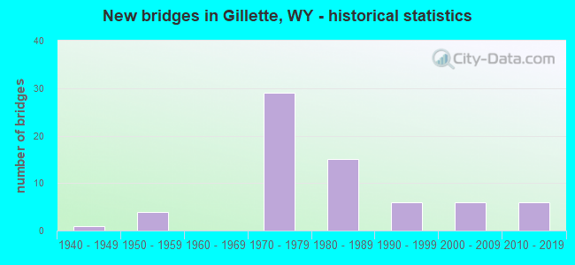
- New bridges - historical statistics
- 11940-1949
- 41950-1959
- 291970-1979
- 151980-1989
- 61990-1999
- 62000-2009
- 62010-2019
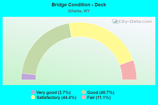
- Bridge Condition - Deck
- 3.7%Very good
- 40.7%Good
- 44.4%Satisfactory
- 11.1%Fair
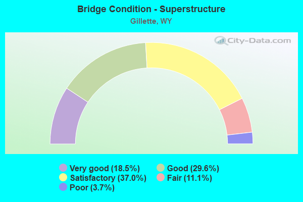
- Bridge Condition - Superstructure
- 18.5%Very good
- 29.6%Good
- 37.0%Satisfactory
- 11.1%Fair
- 3.7%Poor
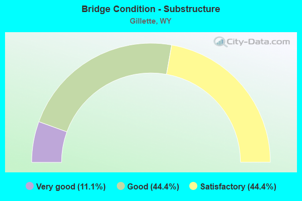
- Bridge Condition - Substructure
- 11.1%Very good
- 44.4%Good
- 44.4%Satisfactory
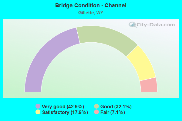
- Bridge Condition - Channel
- 42.9%Very good
- 32.1%Good
- 17.9%Satisfactory
- 7.1%Fair
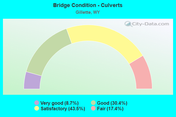
- Bridge Condition - Culverts
- 8.7%Very good
- 30.4%Good
- 43.5%Satisfactory
- 17.4%Fair
Find on map >> Show street view
Structure Number: BFT, Location: Buffalo - Gillette (Lat: 44.278525, Lng: -105.603117), Route carried "on" structure: Interstate 90, Year Built: 1959, Status: Posted for load, Structure Length: 2.06m (6.76ft), Average Daily Traffic: 5,466 (year 2021), Truck Traffic: 4%, Average Future Daily Traffic: 7,652 (year 2041), Design Load: HS 20+Mod, Features Intersected: Machinery Pass
Minimum Vertical Clearance: 30+ m (98+ ft), Kilometerpoint: 195.683, Lanes on structure: 2, Base Highway Network: Yes, Owner: State Highway Agency, Approaching Roadway Width: 11.0m (36.1ft), Skew: 10 degrees, Material/Design: Concrete continuous, Design/Construction: Slab, Number Of Spans In Main Unit: 3, Length of Maximum Span: 7.6m (24.9ft), Curb-To-Curb Width: 11.6m (38.1ft), Out-to-Out Width: 12.5m (41.0ft)
Condition: Deck: Satisfactory, Superstructure: Satisfactory, Substructure: Satisfactory, Operating Rating: 39.8 metric tons, Method Used To Determine Operating Rating: Load Factor (LF), Inventory Rating: 23.9 metric tons, Method Used To Determine Inventory Rating: Load Factor (LF), Structural Evaluation: Somewhat better than minimum adequacy, Deck Geometry: Equal to present minimum criteria, Approach Roadway Alignment: Equal to present desirable criteria, Designated Inspection Frequency: Every 24 months, Inspection Date: May 2021, Deck Structure Type: Concrete Cast-file-Place, Wearing Surface/Protective System: Wearing Surface: Bituminous
Find on map >> Show street view
Structure Number: BFU, Location: Buffalo - Gillette (Lat: 44.278644, Lng: -105.603311), Route carried "on" structure: Interstate 90, Year Built: 1959, Status: Posted for load, Structure Length: 2.06m (6.76ft), Average Daily Traffic: 2,523 (year 2021), Truck Traffic: 17%, Average Future Daily Traffic: 3,532 (year 2041), Design Load: HS 20+Mod, Features Intersected: Machinery Pass
Minimum Vertical Clearance: 30+ m (98+ ft), Kilometerpoint: 195.460, Lanes on structure: 2, Base Highway Network: Yes, Owner: State Highway Agency, Approaching Roadway Width: 11.9m (39.0ft), Skew: 10 degrees, Material/Design: Concrete continuous, Design/Construction: Slab, Number Of Spans In Main Unit: 3, Length of Maximum Span: 7.6m (24.9ft), Curb-To-Curb Width: 11.6m (38.1ft), Out-to-Out Width: 12.5m (41.0ft)
Condition: Deck: Satisfactory, Superstructure: Satisfactory, Substructure: Satisfactory, Operating Rating: 39.8 metric tons, Method Used To Determine Operating Rating: Load Factor (LF), Inventory Rating: 23.9 metric tons, Method Used To Determine Inventory Rating: Load Factor (LF), Structural Evaluation: Somewhat better than minimum adequacy, Deck Geometry: Equal to present minimum criteria, Approach Roadway Alignment: Equal to present desirable criteria, Designated Inspection Frequency: Every 24 months, Inspection Date: May 2021, Deck Structure Type: Concrete Cast-file-Place, Wearing Surface/Protective System: Wearing Surface: Bituminous
Find on map >> Show street view
Structure Number: BFV, Location: Buffalo - Gillette (Lat: 44.295278, Lng: -105.574800), Route carried "on" structure: Interstate 90, Year Built: 1959, Status: Posted for load, Structure Length: 2.06m (6.76ft), Average Daily Traffic: 5,466 (year 2021), Truck Traffic: 4%, Average Future Daily Traffic: 7,652 (year 2041), Design Load: HS 20+Mod, Features Intersected: Machinery Pass
Minimum Vertical Clearance: 30+ m (98+ ft), Kilometerpoint: 198.934, Lanes on structure: 2, Base Highway Network: Yes (Inventory Route: ML9, Subroute: 1), Owner: State Highway Agency, Approaching Roadway Width: 11.0m (36.1ft), Skew: 10 degrees, Material/Design: Concrete continuous, Design/Construction: Slab, Number Of Spans In Main Unit: 3, Length of Maximum Span: 7.6m (24.9ft), Curb-To-Curb Width: 11.6m (38.1ft), Out-to-Out Width: 12.5m (41.0ft)
Condition: Deck: Satisfactory, Superstructure: Satisfactory, Substructure: Satisfactory, Operating Rating: 38.8 metric tons, Method Used To Determine Operating Rating: Load Factor (LF), Inventory Rating: 23.2 metric tons, Method Used To Determine Inventory Rating: Load Factor (LF), Structural Evaluation: Somewhat better than minimum adequacy, Deck Geometry: Equal to present minimum criteria, Approach Roadway Alignment: Equal to present desirable criteria, Designated Inspection Frequency: Every 24 months, Inspection Date: May 2021, Deck Structure Type: Concrete Cast-file-Place, Wearing Surface/Protective System: Wearing Surface: Bituminous, Membrane: Preformed Fabric
Find on map >> Show street view
Structure Number: BFW, Location: Buffalo - Gillette (Lat: 44.295458, Lng: -105.574792), Route carried "on" structure: Interstate 90, Year Built: 1959, Status: Posted for load, Structure Length: 2.06m (6.76ft), Average Daily Traffic: 2,523 (year 2021), Truck Traffic: 17%, Average Future Daily Traffic: 3,532 (year 2041), Design Load: HS 20+Mod, Features Intersected: Machinery Pass
Minimum Vertical Clearance: 30+ m (98+ ft), Kilometerpoint: 198.749, Lanes on structure: 2, Base Highway Network: Yes (Inventory Route: ML9, Subroute: 1), Owner: State Highway Agency, Approaching Roadway Width: 11.0m (36.1ft), Skew: 10 degrees, Material/Design: Concrete continuous, Design/Construction: Slab, Number Of Spans In Main Unit: 3, Length of Maximum Span: 7.6m (24.9ft), Curb-To-Curb Width: 11.6m (38.1ft), Out-to-Out Width: 12.5m (41.0ft)
Condition: Deck: Satisfactory, Superstructure: Satisfactory, Substructure: Satisfactory, Operating Rating: 38.8 metric tons, Method Used To Determine Operating Rating: Load Factor (LF), Inventory Rating: 23.2 metric tons, Method Used To Determine Inventory Rating: Load Factor (LF), Structural Evaluation: Somewhat better than minimum adequacy, Deck Geometry: Equal to present minimum criteria, Approach Roadway Alignment: Equal to present desirable criteria, Designated Inspection Frequency: Every 24 months, Inspection Date: May 2021, Deck Structure Type: Concrete Cast-file-Place, Wearing Surface/Protective System: Wearing Surface: Bituminous
Find on map >> Show street view
Structure Number: BFX, Location: Gillette (Lat: 44.292853, Lng: -105.531114), Route carried "on" structure: Interstate 90, Year Built: 1970, Status: Open, Structure Length: 4.46m (14.63ft), Average Daily Traffic: 5,466 (year 2021), Truck Traffic: 14%, Average Future Daily Traffic: 7,652 (year 2041), Design Load: HS 20+Mod, Features Intersected: WYO 50 / Skyline Drive
Minimum Vertical Clearance: 30+ m (98+ ft), Kilometerpoint: 202.439, Lanes on structure: 2, Lanes under structure: 5, Base Highway Network: Yes, Owner: State Highway Agency, Approaching Roadway Width: 11.6m (38.1ft), Skew: 10 degrees, Material/Design: Concrete continuous, Design/Construction: Frame, Number Of Spans In Main Unit: 3, Length of Maximum Span: 17.1m (56.1ft), Curb-To-Curb Width: 12.2m (40.0ft), Out-to-Out Width: 13.0m (42.7ft)
Condition: Deck: Satisfactory, Superstructure: Fair, Substructure: Satisfactory, Operating Rating: 57.2 metric tons, Method Used To Determine Operating Rating: Load Factor (LF), Inventory Rating: 32.7 metric tons, Method Used To Determine Inventory Rating: Load Factor (LF), Structural Evaluation: Somewhat better than minimum adequacy, Deck Geometry: Better than present minimum criteria, Underclear: High priority of corrective action, Approach Roadway Alignment: Equal to present desirable criteria, Designated Inspection Frequency: Every 24 months, Inspection Date: May 2021, Deck Structure Type: Concrete Cast-file-Place, Wearing Surface/Protective System: Wearing Surface: Latex Concrete
Find on map >> Show street view
Structure Number: BFY, Location: Gillette (Lat: 44.293017, Lng: -105.531022), Route carried "on" structure: Interstate 90, Year Built: 1970, Status: Open, Structure Length: 4.46m (14.63ft), Average Daily Traffic: 3,000 (year 2021), Truck Traffic: 17%, Average Future Daily Traffic: 4,200 (year 2041), Design Load: HS 20+Mod, Features Intersected: WYO 50 / Skyline Drive
Minimum Vertical Clearance: 30+ m (98+ ft), Kilometerpoint: 202.262, Lanes on structure: 2, Lanes under structure: 5, Base Highway Network: Yes (Inventory Route: ML9, Subroute: 1), Owner: State Highway Agency, Approaching Roadway Width: 11.6m (38.1ft), Skew: 10 degrees, Material/Design: Concrete continuous, Design/Construction: Frame, Number Of Spans In Main Unit: 3, Length of Maximum Span: 17.1m (56.1ft), Curb-To-Curb Width: 12.2m (40.0ft), Out-to-Out Width: 13.0m (42.7ft)
Condition: Deck: Good, Superstructure: Satisfactory, Substructure: Satisfactory, Operating Rating: 57.2 metric tons, Method Used To Determine Operating Rating: Load Factor (LF), Inventory Rating: 32.7 metric tons, Method Used To Determine Inventory Rating: Load Factor (LF), Structural Evaluation: Equal to present minimum criteria, Deck Geometry: Better than present minimum criteria, Underclear: High priority of replacement, Approach Roadway Alignment: Equal to present desirable criteria, Length Of Structure Improvement: 5.40m (17.72ft), Designated Inspection Frequency: Every 24 months, Inspection Date: May 2021, Bridge Improvement Cost: $754,000, Roadway Improvement Cost: $75,000, Total Project Cost: $1,131,000, Deck Structure Type: Concrete Cast-file-Place, Wearing Surface/Protective System: Wearing Surface: Epoxy Overlay
Find on map >> Show street view
Structure Number: CBJ, Location: Reno Jct - Gillette (Lat: 44.266517, Lng: -105.493733), Route carried "on" structure: State highway 59, Year Built: 1975, Status: Open, Structure Length: 3.96m (12.99ft), Average Daily Traffic: 30,185 (year 2021), Truck Traffic: 6%, Average Future Daily Traffic: 42,259 (year 2041), Design Load: HS 20, Features Intersected: Donkey Creek
Minimum Vertical Clearance: 30+ m (98+ ft), Kilometerpoint: 180.449, Lanes on structure: 5, Base Highway Network: Yes (Inventory Route: ML4, Subroute: 3), Owner: State Highway Agency, Approaching Roadway Width: 15.5m (50.9ft), Material/Design: Steel continuous, Design/Construction: Stringer/Multi-beam, Number Of Spans In Main Unit: 3, Length of Maximum Span: 15.2m (49.9ft), Curb or Sidewalk Widths: Left: 1.6m (5.2ft), Right: 2.1m (6.9ft), Curb-To-Curb Width: 24.4m (80.1ft), Out-to-Out Width: 29.3m (96.1ft)
Condition: Deck: Satisfactory, Superstructure: Very good, Substructure: Good, Channel: Fair, Operating Rating: 54.4 metric tons, Method Used To Determine Operating Rating: Load Factor (LF), Inventory Rating: 32.7 metric tons, Method Used To Determine Inventory Rating: Load Factor (LF), Structural Evaluation: Better than present minimum criteria, Deck Geometry: Superior to present desirable criteria, Waterway Adequacy: Equal to present desirable criteria, Approach Roadway Alignment: Equal to present desirable criteria, Length Of Structure Improvement: 0.30m (0.98ft), Designated Inspection Frequency: Every 24 months, Inspection Date: July 2020, Bridge Improvement Cost: $5,000, Roadway Improvement Cost: $1,000, Total Project Cost: $7,000, Deck Structure Type: Concrete Cast-file-Place, Wearing Surface/Protective System: Wearing Surface: Latex Concrete
Find on map >> Show street view
Structure Number: CDK, Location: Gillette - Moorcroft (Lat: 44.294822, Lng: -105.383992), Route carried "on" structure: Interstate 90, Year Built: 1976, Status: Open, Structure Length: 4.42m (14.50ft), Average Daily Traffic: 4,001 (year 2021), Truck Traffic: 13%, Average Future Daily Traffic: 5,601 (year 2041), Design Load: HS 20+Mod, Features Intersected: Machinery Pass
Minimum Vertical Clearance: 30+ m (98+ ft), Kilometerpoint: 215.514, Lanes on structure: 2, Base Highway Network: Yes (Inventory Route: ML9, Subroute: 1), Owner: State Highway Agency, Approaching Roadway Width: 11.6m (38.1ft), Skew: 10 degrees, Material/Design: Concrete continuous, Design/Construction: Tee Beam, Number Of Spans In Main Unit: 3, Length of Maximum Span: 17.4m (57.1ft), Curb-To-Curb Width: 12.8m (42.0ft), Out-to-Out Width: 13.6m (44.6ft)
Condition: Deck: Satisfactory, Superstructure: Satisfactory, Substructure: Good, Operating Rating: 51.7 metric tons, Method Used To Determine Operating Rating: Load Factor (LF), Inventory Rating: 30.8 metric tons, Method Used To Determine Inventory Rating: Load Factor (LF), Structural Evaluation: Equal to present minimum criteria, Deck Geometry: Equal to present desirable criteria, Approach Roadway Alignment: Equal to present desirable criteria, Designated Inspection Frequency: Every 24 months, Inspection Date: May 2021, Deck Structure Type: Concrete Cast-file-Place, Wearing Surface/Protective System: Wearing Surface: Latex Concrete
Find on map >> Show street view
Structure Number: CDL, Location: Gillette - Moorcroft (Lat: 44.295050, Lng: -105.383936), Route carried "on" structure: Interstate 90, Year Built: 1976, Status: Open, Structure Length: 4.42m (14.50ft), Average Daily Traffic: 4,040 (year 2021), Truck Traffic: 13%, Average Future Daily Traffic: 5,656 (year 2041), Design Load: HS 20+Mod, Features Intersected: Machinery Pass
Minimum Vertical Clearance: 30+ m (98+ ft), Kilometerpoint: 215.333, Lanes on structure: 2, Base Highway Network: Yes (Inventory Route: ML9, Subroute: 1), Owner: State Highway Agency, Approaching Roadway Width: 11.6m (38.1ft), Skew: 10 degrees, Material/Design: Concrete continuous, Design/Construction: Tee Beam, Number Of Spans In Main Unit: 3, Length of Maximum Span: 17.4m (57.1ft), Curb-To-Curb Width: 12.8m (42.0ft), Out-to-Out Width: 13.6m (44.6ft)
Condition: Deck: Satisfactory, Superstructure: Poor, Substructure: Satisfactory, Operating Rating: 53.9 metric tons, Method Used To Determine Operating Rating: Load Factor (LF), Inventory Rating: 32.3 metric tons, Method Used To Determine Inventory Rating: Load Factor (LF), Structural Evaluation: Meets minimum limits, Deck Geometry: Equal to present desirable criteria, Approach Roadway Alignment: Equal to present desirable criteria, Designated Inspection Frequency: Every 24 months, Inspection Date: May 2021, Deck Structure Type: Concrete Cast-file-Place, Wearing Surface/Protective System: Wearing Surface: Latex Concrete
Find on map >> Show street view
Structure Number: CDM, Location: Gillette - Moorcroft (Lat: 44.293058, Lng: -105.371933), Route carried "on" structure: County highway 3, Year Built: 1976, Status: Open, Structure Length: 8.17m (26.80ft), Average Daily Traffic: 1,287 (year 2021), Truck Traffic: 8%, Average Future Daily Traffic: 1,802 (year 2041), Design Load: HS 20+Mod, Features Intersected: I-90
Minimum Vertical Clearance: 30+ m (98+ ft), Kilometerpoint: 1.159, Lanes on structure: 2, Lanes under structure: 4, Owner: State Highway Agency, Approaching Roadway Width: 9.8m (32.2ft), Skew: 1 degrees, Material/Design: Steel continuous, Design/Construction: Stringer/Multi-beam, Number Of Spans In Main Unit: 2, Length of Maximum Span: 40.2m (131.9ft), Curb-To-Curb Width: 9.8m (32.2ft), Out-to-Out Width: 10.6m (34.8ft)
Condition: Deck: Fair, Superstructure: Satisfactory, Substructure: Satisfactory, Operating Rating: 62.6 metric tons, Method Used To Determine Operating Rating: Load Factor (LF), Inventory Rating: 37.2 metric tons, Method Used To Determine Inventory Rating: Load Factor (LF), Structural Evaluation: Equal to present minimum criteria, Deck Geometry: Somewhat better than minimum adequacy, Underclear: Somewhat better than minimum adequacy, Approach Roadway Alignment: Better than present minimum criteria, Length Of Structure Improvement: 27.68m (90.81ft), Designated Inspection Frequency: Every 24 months, Inspection Date: May 2021, Bridge Improvement Cost: $61,000, Roadway Improvement Cost: $30,000, Total Project Cost: $93,000 ( Estimate for 2015), Deck Structure Type: Concrete Cast-file-Place
Find on map >> Show street view
Structure Number: CRA, Location: Gillette (Lat: 44.281608, Lng: -105.510147), Route carried "on" structure: Interstate 90, Year Built: 1970, Status: Open, Structure Length: 6.04m (19.82ft), Average Daily Traffic: 5,232 (year 2021), Truck Traffic: 16%, Average Future Daily Traffic: 7,325 (year 2041), Design Load: HS 20+Mod, Features Intersected: 4-J Road
Minimum Vertical Clearance: 30+ m (98+ ft), Kilometerpoint: 204.535, Lanes on structure: 2, Lanes under structure: 4, Base Highway Network: Yes (Inventory Route: ML9, Subroute: 1), Owner: State Highway Agency, Approaching Roadway Width: 11.6m (38.1ft), Skew: 14 degrees, Material/Design: Concrete continuous, Design/Construction: Box Beam or Girders - Multiple, Number Of Spans In Main Unit: 3, Length of Maximum Span: 23.1m (75.8ft), Curb-To-Curb Width: 12.2m (40.0ft), Out-to-Out Width: 13.0m (42.7ft)
Condition: Deck: Satisfactory, Superstructure: Satisfactory, Substructure: Good, Operating Rating: 72.6 metric tons, Method Used To Determine Operating Rating: Load Factor (LF), Inventory Rating: 43.5 metric tons, Method Used To Determine Inventory Rating: Load Factor (LF), Structural Evaluation: Equal to present minimum criteria, Deck Geometry: Better than present minimum criteria, Underclear: High priority of corrective action, Approach Roadway Alignment: Equal to present desirable criteria, Designated Inspection Frequency: Every 24 months, Inspection Date: May 2021, Deck Structure Type: Concrete Cast-file-Place, Wearing Surface/Protective System: Wearing Surface: Latex Concrete
Find on map >> Show street view
Structure Number: CSC, Location: Gillette (Lat: 44.281875, Lng: -105.510172), Route carried "on" structure: Interstate 90, Year Built: 1970, Status: Open, Structure Length: 6.04m (19.82ft), Average Daily Traffic: 3,000 (year 2021), Truck Traffic: 17%, Average Future Daily Traffic: 4,200 (year 2041), Design Load: HS 20+Mod, Features Intersected: 4-J Road
Minimum Vertical Clearance: 30+ m (98+ ft), Kilometerpoint: 204.345, Lanes on structure: 2, Lanes under structure: 4, Base Highway Network: Yes (Inventory Route: ML9, Subroute: 1), Owner: State Highway Agency, Approaching Roadway Width: 11.6m (38.1ft), Skew: 14 degrees, Material/Design: Concrete continuous, Design/Construction: Box Beam or Girders - Multiple, Number Of Spans In Main Unit: 3, Length of Maximum Span: 23.2m (76.1ft), Curb-To-Curb Width: 12.2m (40.0ft), Out-to-Out Width: 13.0m (42.7ft)
Condition: Deck: Good, Superstructure: Satisfactory, Substructure: Satisfactory, Operating Rating: 72.6 metric tons, Method Used To Determine Operating Rating: Load Factor (LF), Inventory Rating: 43.5 metric tons, Method Used To Determine Inventory Rating: Load Factor (LF), Structural Evaluation: Equal to present minimum criteria, Deck Geometry: Better than present minimum criteria, Underclear: High priority of corrective action, Approach Roadway Alignment: Equal to present desirable criteria, Length Of Structure Improvement: 0.30m (0.98ft), Designated Inspection Frequency: Every 24 months, Inspection Date: May 2021, Bridge Improvement Cost: $1,000, Roadway Improvement Cost: $1,000, Total Project Cost: $3,000 ( Estimate for 2015), Deck Structure Type: Concrete Cast-file-Place, Wearing Surface/Protective System: Wearing Surface: Latex Concrete
Find on map >> Show street view
Structure Number: CSH, Location: Gillette (Lat: 44.293125, Lng: -105.514394), Route carried "on" structure: US 14, Year Built: 1941, Year Reconstructed: 1979, Status: Open, Structure Length: 0.65m (2.13ft), Average Daily Traffic: 5,942 (year 2021), Truck Traffic: 6%, Average Future Daily Traffic: 8,319 (year 2041), Design Load: HS 20, Features Intersected: Burlington Supply Ditch, Facility Carried by Structure: WYO 59
Minimum Vertical Clearance: 30+ m (98+ ft), Kilometerpoint: 185.028, Lanes on structure: 5, Base Highway Network: Yes, Owner: State Highway Agency, Approaching Roadway Width: 18.3m (60.0ft), Skew: 2 degrees, Material/Design: Steel, Design/Construction: Culvert, Number Of Spans In Main Unit: 2, Length of Maximum Span: 2.6m (8.5ft)
Condition: Channel: Good, Culverts: Fair, Operating Rating: 32.7 metric tons, Method Used To Determine Operating Rating: Field evaluation and documented engineering judgment, Inventory Rating: 32.7 metric tons, Method Used To Determine Inventory Rating: Field evaluation and documented engineering judgment, Structural Evaluation: Somewhat better than minimum adequacy, Waterway Adequacy: Equal to present desirable criteria, Approach Roadway Alignment: Equal to present desirable criteria, Designated Inspection Frequency: Every 24 months, Inspection Date: July 2020, Bridge Improvement Cost: $1,000, Roadway Improvement Cost: $1,000, Total Project Cost: $3,000
Find on map >> Show street view
Structure Number: CYK, Location: Gillette (Lat: 44.279447, Lng: -105.494458), Route carried "on" structure: Interstate 90, Year Built: 1971, Status: Open, Structure Length: 6.71m (22.01ft), Average Daily Traffic: 4,987 (year 2021), Truck Traffic: 16%, Average Future Daily Traffic: 6,982 (year 2041), Design Load: HS 20+Mod, Features Intersected: WYO 59
Minimum Vertical Clearance: 30+ m (98+ ft), Kilometerpoint: 205.850, Lanes on structure: 2, Lanes under structure: 6, Base Highway Network: Yes (Inventory Route: ML9, Subroute: 1), Owner: State Highway Agency, Approaching Roadway Width: 11.6m (38.1ft), Skew: 10 degrees, Material/Design: Steel continuous, Design/Construction: Stringer/Multi-beam, Number Of Spans In Main Unit: 2, Length of Maximum Span: 32.9m (107.9ft), Curb-To-Curb Width: 12.8m (42.0ft), Out-to-Out Width: 13.6m (44.6ft)
Condition: Deck: Good, Superstructure: Good, Substructure: Good, Operating Rating: 56.2 metric tons, Method Used To Determine Operating Rating: Load Factor (LF), Inventory Rating: 33.6 metric tons, Method Used To Determine Inventory Rating: Load Factor (LF), Structural Evaluation: Better than present minimum criteria, Deck Geometry: Equal to present desirable criteria, Underclear: High priority of corrective action, Approach Roadway Alignment: Equal to present desirable criteria, Designated Inspection Frequency: Every 24 months, Inspection Date: May 2021, Deck Structure Type: Concrete Cast-file-Place, Wearing Surface/Protective System: Wearing Surface: Latex Concrete
Find on map >> Show street view
Structure Number: CYL, Location: Gillette (Lat: 44.279639, Lng: -105.494444), Route carried "on" structure: Interstate 90, Year Built: 1971, Status: Open, Structure Length: 6.71m (22.01ft), Average Daily Traffic: 3,750 (year 2021), Truck Traffic: 17%, Average Future Daily Traffic: 5,250 (year 2041), Design Load: HS 20+Mod, Features Intersected: WYO 59
Minimum Vertical Clearance: 30+ m (98+ ft), Kilometerpoint: 205.665, Lanes on structure: 2, Lanes under structure: 6, Base Highway Network: Yes (Inventory Route: ML9, Subroute: 1), Owner: State Highway Agency, Approaching Roadway Width: 11.6m (38.1ft), Skew: 10 degrees, Material/Design: Steel continuous, Design/Construction: Stringer/Multi-beam, Number Of Spans In Main Unit: 2, Length of Maximum Span: 32.9m (107.9ft), Curb-To-Curb Width: 12.8m (42.0ft), Out-to-Out Width: 13.6m (44.6ft)
Condition: Deck: Good, Superstructure: Good, Substructure: Good, Operating Rating: 56.2 metric tons, Method Used To Determine Operating Rating: Load Factor (LF), Inventory Rating: 33.6 metric tons, Method Used To Determine Inventory Rating: Load Factor (LF), Structural Evaluation: Better than present minimum criteria, Deck Geometry: Equal to present desirable criteria, Underclear: High priority of corrective action, Approach Roadway Alignment: Equal to present desirable criteria, Designated Inspection Frequency: Every 24 months, Inspection Date: May 2021, Deck Structure Type: Concrete Cast-file-Place, Wearing Surface/Protective System: Wearing Surface: Latex Concrete
Find on map >> Show street view
Structure Number: CYM, Location: Gillette (Lat: 44.279744, Lng: -105.479122), Route carried "on" structure: Interstate 90, Year Built: 1971, Status: Open, Structure Length: 4.60m (15.09ft), Average Daily Traffic: 4,532 (year 2021), Truck Traffic: 16%, Average Future Daily Traffic: 6,345 (year 2041), Design Load: HS 20+Mod, Features Intersected: Butler Speath Road
Minimum Vertical Clearance: 30+ m (98+ ft), Kilometerpoint: 207.076, Lanes on structure: 2, Lanes under structure: 2, Base Highway Network: Yes (Inventory Route: ML9, Subroute: 1), Owner: State Highway Agency, Approaching Roadway Width: 11.6m (38.1ft), Skew: 11 degrees, Material/Design: Concrete continuous, Design/Construction: Tee Beam, Number Of Spans In Main Unit: 3, Length of Maximum Span: 18.0m (59.1ft), Curb-To-Curb Width: 12.8m (42.0ft), Out-to-Out Width: 13.6m (44.6ft)
Condition: Deck: Good, Superstructure: Satisfactory, Substructure: Good, Operating Rating: 60.8 metric tons, Method Used To Determine Operating Rating: Load Factor (LF), Inventory Rating: 36.3 metric tons, Method Used To Determine Inventory Rating: Load Factor (LF), Structural Evaluation: Equal to present minimum criteria, Deck Geometry: Equal to present desirable criteria, Underclear: High priority of corrective action, Approach Roadway Alignment: Equal to present desirable criteria, Designated Inspection Frequency: Every 24 months, Inspection Date: May 2021, Deck Structure Type: Concrete Cast-file-Place, Wearing Surface/Protective System: Wearing Surface: Latex Concrete
Find on map >> Show street view
Structure Number: CYN, Location: Gillette (Lat: 44.279942, Lng: -105.479100), Route carried "on" structure: Interstate 90, Year Built: 1971, Status: Open, Structure Length: 4.15m (13.62ft), Average Daily Traffic: 3,750 (year 2021), Truck Traffic: 17%, Average Future Daily Traffic: 5,250 (year 2041), Design Load: HS 20+Mod, Features Intersected: Butler Speath Road
Minimum Vertical Clearance: 30+ m (98+ ft), Kilometerpoint: 206.892, Lanes on structure: 2, Lanes under structure: 2, Base Highway Network: Yes (Inventory Route: ML9, Subroute: 1), Owner: State Highway Agency, Approaching Roadway Width: 11.6m (38.1ft), Skew: 11 degrees, Material/Design: Concrete continuous, Design/Construction: Stringer/Multi-beam, Number Of Spans In Main Unit: 3, Length of Maximum Span: 18.0m (59.1ft), Curb-To-Curb Width: 12.8m (42.0ft), Out-to-Out Width: 13.6m (44.6ft)
Condition: Deck: Good, Superstructure: Fair, Substructure: Good, Operating Rating: 50.8 metric tons, Method Used To Determine Operating Rating: Load Factor (LF), Inventory Rating: 29.9 metric tons, Method Used To Determine Inventory Rating: Load Factor (LF), Structural Evaluation: Somewhat better than minimum adequacy, Deck Geometry: Equal to present desirable criteria, Underclear: Meets minimum limits, Approach Roadway Alignment: Equal to present desirable criteria, Designated Inspection Frequency: Every 24 months, Inspection Date: May 2021, Deck Structure Type: Concrete Cast-file-Place, Wearing Surface/Protective System: Wearing Surface: Epoxy Overlay
Find on map >> Show street view
Structure Number: CYO, Location: Gillette (Lat: 44.284758, Lng: -105.471261), Route carried "on" structure: Interstate 90, Year Built: 1974, Status: Open, Structure Length: 1.48m (4.86ft), Average Daily Traffic: 4,300 (year 2021), Truck Traffic: 17%, Average Future Daily Traffic: 6,020 (year 2041), Design Load: HS 20+Mod, Features Intersected: Stonepile Creek
Minimum Vertical Clearance: 30+ m (98+ ft), Kilometerpoint: 207.945, Lanes on structure: 6, Base Highway Network: Yes (Inventory Route: ML9, Subroute: 1), Owner: State Highway Agency, Approaching Roadway Width: 54.6m (179.1ft), Skew: 3 degrees, Material/Design: Concrete continuous, Design/Construction: Culvert, Number Of Spans In Main Unit: 4, Length of Maximum Span: 3.0m (9.8ft)
Condition: Channel: Good, Culverts: Fair, Operating Rating: 32.7 metric tons, Method Used To Determine Operating Rating: Field evaluation and documented engineering judgment, Inventory Rating: 32.7 metric tons, Method Used To Determine Inventory Rating: Field evaluation and documented engineering judgment, Structural Evaluation: Somewhat better than minimum adequacy, Waterway Adequacy: Equal to present desirable criteria, Approach Roadway Alignment: Equal to present desirable criteria, Designated Inspection Frequency: Every 24 months, Inspection Date: May 2021
Find on map >> Show street view
Structure Number: DAI, Location: Gillette (Lat: 44.289819, Lng: -105.467297), Route carried "on" structure: Interstate 90, Year Built: 1972, Status: Open, Structure Length: 10.27m (33.69ft), Average Daily Traffic: 4,250 (year 2021), Truck Traffic: 17%, Average Future Daily Traffic: 5,950 (year 2041), Design Load: HS 20+Mod, Features Intersected: BNSF / US 14/16
Minimum Vertical Clearance: 30+ m (98+ ft), Kilometerpoint: 208.590, Lanes on structure: 4, Lanes under structure: 5, Base Highway Network: Yes (Inventory Route: ML9, Subroute: 1), Owner: State Highway Agency, Approaching Roadway Width: 12.8m (42.0ft), Skew: 2 degrees, Material/Design: Steel continuous, Design/Construction: Stringer/Multi-beam, Number Of Spans In Main Unit: 4, Length of Maximum Span: 33.8m (110.9ft), Curb-To-Curb Width: 28.0m (91.9ft), Out-to-Out Width: 28.9m (94.8ft)
Condition: Deck: Fair, Superstructure: Good, Substructure: Satisfactory, Operating Rating: 51.3 metric tons, Method Used To Determine Operating Rating: Load Factor (LF), Inventory Rating: 30.7 metric tons, Method Used To Determine Inventory Rating: Load Factor (LF), Structural Evaluation: Equal to present minimum criteria, Deck Geometry: Superior to present desirable criteria, Underclear: Better than present minimum criteria, Approach Roadway Alignment: Equal to present desirable criteria, Designated Inspection Frequency: Every 24 months, Inspection Date: May 2021, Deck Structure Type: Concrete Cast-file-Place, Wearing Surface/Protective System: Wearing Surface: Bituminous
Find on map >> Show street view
Structure Number: DAK, Location: Gillette - Moorcroft (Lat: 44.295069, Lng: -105.426861), Route carried "on" structure: Interstate 90, Year Built: 1976, Status: Open, Structure Length: 4.42m (14.50ft), Average Daily Traffic: 4,001 (year 2021), Truck Traffic: 13%, Average Future Daily Traffic: 5,601 (year 2041), Design Load: HS 20+Mod, Features Intersected: Hi-Line Rd
Minimum Vertical Clearance: 30+ m (98+ ft), Kilometerpoint: 212.087, Lanes on structure: 2, Lanes under structure: 2, Base Highway Network: Yes (Inventory Route: ML9, Subroute: 1), Owner: State Highway Agency, Approaching Roadway Width: 11.6m (38.1ft), Skew: 10 degrees, Material/Design: Concrete continuous, Design/Construction: Tee Beam, Number Of Spans In Main Unit: 3, Length of Maximum Span: 17.4m (57.1ft), Curb-To-Curb Width: 12.8m (42.0ft), Out-to-Out Width: 13.6m (44.6ft)
Condition: Deck: Satisfactory, Superstructure: Good, Substructure: Satisfactory, Operating Rating: 54.4 metric tons, Method Used To Determine Operating Rating: Load Factor (LF), Inventory Rating: 32.7 metric tons, Method Used To Determine Inventory Rating: Load Factor (LF), Structural Evaluation: Equal to present minimum criteria, Deck Geometry: Equal to present desirable criteria, Underclear: Superior to present desirable criteria, Approach Roadway Alignment: Equal to present desirable criteria, Designated Inspection Frequency: Every 24 months, Inspection Date: May 2021, Deck Structure Type: Concrete Cast-file-Place, Wearing Surface/Protective System: Wearing Surface: Latex Concrete
Find on map >> Show street view
Structure Number: DAL, Location: Gillette - Moorcroft (Lat: 44.295303, Lng: -105.426869), Route carried "on" structure: Interstate 90, Year Built: 1976, Status: Open, Structure Length: 4.42m (14.50ft), Average Daily Traffic: 5,085 (year 2021), Truck Traffic: 17%, Average Future Daily Traffic: 7,119 (year 2041), Design Load: HS 20+Mod, Features Intersected: Hi-Line Rd
Minimum Vertical Clearance: 30+ m (98+ ft), Kilometerpoint: 211.902, Lanes on structure: 2, Lanes under structure: 2, Base Highway Network: Yes (Inventory Route: ML9, Subroute: 1), Owner: State Highway Agency, Approaching Roadway Width: 11.6m (38.1ft), Skew: 10 degrees, Material/Design: Concrete continuous, Design/Construction: Tee Beam, Number Of Spans In Main Unit: 3, Length of Maximum Span: 17.4m (57.1ft), Curb-To-Curb Width: 12.8m (42.0ft), Out-to-Out Width: 13.6m (44.6ft)
Condition: Deck: Satisfactory, Superstructure: Good, Substructure: Satisfactory, Operating Rating: 54.4 metric tons, Method Used To Determine Operating Rating: Load Factor (LF), Inventory Rating: 32.7 metric tons, Method Used To Determine Inventory Rating: Load Factor (LF), Structural Evaluation: Equal to present minimum criteria, Deck Geometry: Equal to present desirable criteria, Underclear: Better than present minimum criteria, Approach Roadway Alignment: Equal to present desirable criteria, Designated Inspection Frequency: Every 24 months, Inspection Date: May 2021, Deck Structure Type: Concrete Cast-file-Place, Wearing Surface/Protective System: Wearing Surface: Latex Concrete
Find on map >> Show street view
Structure Number: DEH, Location: Gillette (Lat: 44.296447, Lng: -105.529200), Route carried "on" structure: US 14, Year Built: 1981, Status: Open, Structure Length: 1.16m (3.81ft), Average Daily Traffic: 13,597 (year 2021), Truck Traffic: 6%, Average Future Daily Traffic: 19,036 (year 2041), Design Load: HS 20, Features Intersected: Stonepile Creek, Facility Carried by Structure: WYO 59
Minimum Vertical Clearance: 30+ m (98+ ft), Kilometerpoint: 186.402, Lanes on structure: 4, Base Highway Network: Yes (Inventory Route: ML4, Subroute: 3), Owner: State Highway Agency, Approaching Roadway Width: 18.0m (59.1ft), Material/Design: Concrete continuous, Design/Construction: Culvert, Number Of Spans In Main Unit: 4, Length of Maximum Span: 2.7m (8.9ft)
Condition: Channel: Good, Culverts: Satisfactory, Operating Rating: 32.7 metric tons, Method Used To Determine Operating Rating: Field evaluation and documented engineering judgment, Inventory Rating: 32.7 metric tons, Method Used To Determine Inventory Rating: Field evaluation and documented engineering judgment, Structural Evaluation: Equal to present minimum criteria, Waterway Adequacy: Equal to present desirable criteria, Approach Roadway Alignment: Equal to present desirable criteria, Length Of Structure Improvement: 0.15m (0.49ft), Designated Inspection Frequency: Every 24 months, Inspection Date: July 2020, Bridge Improvement Cost: $1,000, Roadway Improvement Cost: $1,000, Total Project Cost: $3,000
Find on map >> Show street view
Structure Number: DKY, Location: Butler-Spaeth Rd Gillette (Lat: 44.289006, Lng: -105.479081), Route carried "on" structure: City street 4600, Year Built: 1978, Status: Open, Structure Length: 1.95m (6.40ft), Average Daily Traffic: 5,978 (year 2021), Truck Traffic: 10%, Average Future Daily Traffic: 8,369 (year 2041), Features Intersected: Stonepile Creek, Facility Carried by Structure: Butler Spaeth Road
Minimum Vertical Clearance: 30+ m (98+ ft), Kilometerpoint: 160.302, Lanes on structure: 2, Owner: Town or Township Highway Agency, Approaching Roadway Width: 14.9m (48.9ft), Material/Design: Concrete continuous, Design/Construction: Culvert, Number Of Spans In Main Unit: 6, Length of Maximum Span: 3.0m (9.8ft), Curb or Sidewalk Widths: Left: 1.5m (4.9ft), Right: 1.5m (4.9ft)
Condition: Channel: Satisfactory, Culverts: Satisfactory, Operating Rating: 80.4 metric tons, Method Used To Determine Operating Rating: Load Factor (LF), Inventory Rating: 48.3 metric tons, Method Used To Determine Inventory Rating: Load Factor (LF), Structural Evaluation: Equal to present minimum criteria, Waterway Adequacy: Better than present minimum criteria, Approach Roadway Alignment: Equal to present desirable criteria, Designated Inspection Frequency: Every 24 months, Inspection Date: Febuary 2022
Find on map >> Show street view
Structure Number: DVW, Location: North Burma Road Gillette (Lat: 44.299436, Lng: -105.519497), Route carried "on" structure: City street 4612, Year Built: 1979, Status: Posted for load, Structure Length: 1.60m (5.25ft), Average Daily Traffic: 5,404 (year 2021), Truck Traffic: 4%, Average Future Daily Traffic: 7,566 (year 2041), Design Load: HS 20, Features Intersected: Little N F Dead Horse Ck, Facility Carried by Structure: N. Burma Avenue
Minimum Vertical Clearance: 30+ m (98+ ft), Kilometerpoint: 161.787, Lanes on structure: 2, Owner: Town or Township Highway Agency, Approaching Roadway Width: 15.2m (49.9ft), Skew: 2 degrees, Material/Design: Concrete continuous, Design/Construction: Culvert, Number Of Spans In Main Unit: 5, Length of Maximum Span: 3.0m (9.8ft)
Condition: Channel: Very good, Culverts: Fair, Operating Rating: 32.7 metric tons, Method Used To Determine Operating Rating: Field evaluation and documented engineering judgment, Inventory Rating: 32.7 metric tons, Method Used To Determine Inventory Rating: Field evaluation and documented engineering judgment, Structural Evaluation: Somewhat better than minimum adequacy, Waterway Adequacy: Equal to present desirable criteria, Approach Roadway Alignment: Equal to present desirable criteria, Length Of Structure Improvement: 1.89m (6.20ft), Designated Inspection Frequency: Every 24 months, Inspection Date: Febuary 2022, Bridge Improvement Cost: $12,000, Roadway Improvement Cost: $30,000, Total Project Cost: $48,000
Find on map >> Show street view
Structure Number: EGL, Location: Gillette (Lat: 44.292697, Lng: -105.490311), Route carried "on" structure: State highway 14, Year Built: 1984, Status: Open, Structure Length: 0.77m (2.53ft), Average Daily Traffic: 5,677 (year 2021), Truck Traffic: 6%, Average Future Daily Traffic: 7,948 (year 2041), Design Load: HS 20, Features Intersected: Stonepile Creek, Facility Carried by Structure: WYO 51
Minimum Vertical Clearance: 30+ m (98+ ft), Kilometerpoint: 203.445, Lanes on structure: 4, Base Highway Network: Yes, Owner: State Highway Agency, Approaching Roadway Width: 18.3m (60.0ft), Material/Design: Concrete continuous, Design/Construction: Culvert, Number Of Spans In Main Unit: 3, Length of Maximum Span: 2.4m (7.9ft)
Condition: Channel: Good, Culverts: Fair, Operating Rating: 50.4 metric tons, Method Used To Determine Operating Rating: Allowable Stress (AS), Inventory Rating: 32.4 metric tons, Method Used To Determine Inventory Rating: Allowable Stress (AS), Structural Evaluation: Somewhat better than minimum adequacy, Waterway Adequacy: Equal to present desirable criteria, Approach Roadway Alignment: Equal to present desirable criteria, Designated Inspection Frequency: Every 24 months, Inspection Date: July 2020
Find on map >> Show street view
Structure Number: EOF, Location: Four J Road Gillette (Lat: 44.257875, Lng: -105.537708), Route carried "on" structure: State highway 50, Year Built: 1983, Status: Open, Structure Length: 1.68m (5.51ft), Average Daily Traffic: 3,260 (year 2021), Truck Traffic: 5%, Average Future Daily Traffic: 4,564 (year 2041), Design Load: HS 20, Features Intersected: Donkey Creek, Facility Carried by Structure: W 4-J Road
Minimum Vertical Clearance: 30+ m (98+ ft), Kilometerpoint: 5.715, Lanes on structure: 2, Owner: County Highway Agency, Approaching Roadway Width: 12.2m (40.0ft), Material/Design: Steel, Design/Construction: Stringer/Multi-beam, Number Of Spans In Main Unit: 1, Length of Maximum Span: 16.2m (53.1ft), Curb-To-Curb Width: 12.2m (40.0ft), Out-to-Out Width: 13.1m (43.0ft)
Condition: Deck: Good, Superstructure: Good, Substructure: Good, Channel: Very good, Operating Rating: 39.9 metric tons, Method Used To Determine Operating Rating: Allowable Stress (AS), Inventory Rating: 22.7 metric tons, Method Used To Determine Inventory Rating: Allowable Stress (AS), Structural Evaluation: Equal to present minimum criteria, Deck Geometry: Equal to present minimum criteria, Waterway Adequacy: Better than present minimum criteria, Approach Roadway Alignment: Equal to present desirable criteria, Designated Inspection Frequency: Every 24 months, Inspection Date: Febuary 2022, Deck Structure Type: Concrete Cast-file-Place, Wearing Surface/Protective System: Wearing Surface: Bituminous
Find on map >> Show street view
Structure Number: FBR, Location: Gillette/Gurley Ave.Viad. (Lat: 44.291525, Lng: -105.488931), Route carried "on" structure: City street 4609, Year Built: 1982, Status: Posted for load, Structure Length: 29.93m (98.20ft), Average Daily Traffic: 8,795 (year 2021), Truck Traffic: 4%, Average Future Daily Traffic: 12,313 (year 2041), Design Load: HS 20, Features Intersected: BNSF / US 14/16, Facility Carried by Structure: S Gurley Avenue
Minimum Vertical Clearance: 30+ m (98+ ft), Kilometerpoint: 160.730, Lanes on structure: 2, Lanes under structure: 4, Owner: Town or Township Highway Agency, Approaching Roadway Width: 9.8m (32.2ft), Material/Design: Steel continuous, Design/Construction: Stringer/Multi-beam, Number Of Spans In Main Unit: 10, Length of Maximum Span: 54.9m (180.1ft), Curb-To-Curb Width: 9.8m (32.2ft), Out-to-Out Width: 10.7m (35.1ft)
Condition: Deck: Fair, Superstructure: Fair, Substructure: Good, Operating Rating: 62.6 metric tons, Method Used To Determine Operating Rating: Allowable Stress (AS), Inventory Rating: 35.4 metric tons, Method Used To Determine Inventory Rating: Allowable Stress (AS), Structural Evaluation: Somewhat better than minimum adequacy, Deck Geometry: Meets minimum limits, Underclear: Equal to present minimum criteria, Approach Roadway Alignment: Equal to present minimum criteria, Length Of Structure Improvement: 6.10m (20.01ft), Designated Inspection Frequency: Every 24 months, Inspection Date: Febuary 2022, Bridge Improvement Cost: $7,000, Roadway Improvement Cost: $1,000, Total Project Cost: $11,000, Deck Structure Type: Concrete Cast-file-Place, Wearing Surface/Protective System: Wearing Surface: Latex Concrete, Deck Protection: Epoxy Coated Reinforcing
Find on map >> Show street view
Structure Number: FDR, Location: Gillette (Lat: 44.298533, Lng: -105.512703), Route carried "on" structure: City street 4611, Year Built: 1982, Status: Posted for load, Structure Length: 1.82m (5.97ft), Average Daily Traffic: 5,239 (year 2021), Truck Traffic: 4%, Average Future Daily Traffic: 7,335 (year 2041), Design Load: HS 20, Features Intersected: Stonepile Creek, Facility Carried by Structure: Cl Cnty Rd 117
Minimum Vertical Clearance: 30+ m (98+ ft), Kilometerpoint: 1.521, Lanes on structure: 2, Owner: Town or Township Highway Agency, Approaching Roadway Width: 15.2m (49.9ft), Skew: 3 degrees, Material/Design: Concrete continuous, Design/Construction: Culvert, Number Of Spans In Main Unit: 6, Length of Maximum Span: 2.4m (7.9ft), Curb or Sidewalk Widths: Left: 1.5m (4.9ft), Right: 1.7m (5.6ft), Out-to-Out Width: 21.3m (69.9ft)
Condition: Channel: Very good, Culverts: Satisfactory, Operating Rating: 80.7 metric tons, Method Used To Determine Operating Rating: Allowable Stress (AS), Inventory Rating: 48.1 metric tons, Method Used To Determine Inventory Rating: Allowable Stress (AS), Structural Evaluation: Equal to present minimum criteria, Waterway Adequacy: Equal to present desirable criteria, Approach Roadway Alignment: Equal to present desirable criteria, Length Of Structure Improvement: 0.37m (1.21ft), Designated Inspection Frequency: Every 24 months, Inspection Date: Febuary 2022, Bridge Improvement Cost: $4,000, Roadway Improvement Cost: $1,000, Total Project Cost: $6,000
Find on map >> Show street view
Structure Number: FDS, Location: Gillette (Lat: 44.298761, Lng: -105.522675), Route carried "on" structure: City street 4611, Year Built: 1982, Status: Posted for load, Structure Length: 1.04m (3.41ft), Average Daily Traffic: 3,065 (year 2021), Truck Traffic: 4%, Average Future Daily Traffic: 4,291 (year 2041), Features Intersected: Stonepile Creek, Facility Carried by Structure: Cl Cnty Rd 117
Minimum Vertical Clearance: 30+ m (98+ ft), Kilometerpoint: 0.710, Lanes on structure: 2, Owner: Town or Township Highway Agency, Approaching Roadway Width: 14.6m (47.9ft), Material/Design: Concrete continuous, Design/Construction: Culvert, Number Of Spans In Main Unit: 4, Length of Maximum Span: 2.4m (7.9ft)
Condition: Channel: Very good, Culverts: Satisfactory, Operating Rating: 32.7 metric tons, Method Used To Determine Operating Rating: Field evaluation and documented engineering judgment, Inventory Rating: 32.7 metric tons, Method Used To Determine Inventory Rating: Field evaluation and documented engineering judgment, Structural Evaluation: Equal to present minimum criteria, Waterway Adequacy: Equal to present desirable criteria, Approach Roadway Alignment: Equal to present desirable criteria, Designated Inspection Frequency: Every 24 months, Inspection Date: Febuary 2022
Find on map >> Show street view
Structure Number: FDT, Location: Gillette Streets (Lat: 44.293742, Lng: -105.496703), Route carried "on" structure: City street 160-2, Year Built: 1982, Status: Posted for load, Structure Length: 1.45m (4.76ft), Average Daily Traffic: 4,000 (year 2021), Truck Traffic: 10%, Average Future Daily Traffic: 5,600 (year 2041), Design Load: HS 20, Features Intersected: Stonepile Creek, Facility Carried by Structure: S. Brooks Avenue
Minimum Vertical Clearance: 30+ m (98+ ft), Kilometerpoint: 160.959, Lanes on structure: 2, Owner: Town or Township Highway Agency, Approaching Roadway Width: 11.0m (36.1ft), Material/Design: Concrete continuous, Design/Construction: Culvert, Number Of Spans In Main Unit: 5, Length of Maximum Span: 2.7m (8.9ft)
Condition: Channel: Very good, Culverts: Good, Operating Rating: 46.3 metric tons, Method Used To Determine Operating Rating: Allowable Stress (AS), Inventory Rating: 27.2 metric tons, Method Used To Determine Inventory Rating: Allowable Stress (AS), Structural Evaluation: Equal to present minimum criteria, Waterway Adequacy: Equal to present desirable criteria, Approach Roadway Alignment: Equal to present desirable criteria, Length Of Structure Improvement: 0.61m (2.00ft), Designated Inspection Frequency: Every 24 months, Inspection Date: Febuary 2021, Bridge Improvement Cost: $2,000, Roadway Improvement Cost: $1,000, Total Project Cost: $4,000
Find on map >> Show street view
Structure Number: FGD, Location: Gillette-Echeta Road (Lat: 44.297031, Lng: -105.528100), Route carried "on" structure: City street 4616, Year Built: 1984, Status: Posted for load, Structure Length: 1.16m (3.81ft), Average Daily Traffic: 1,262 (year 2021), Truck Traffic: 10%, Average Future Daily Traffic: 1,767 (year 2041), Features Intersected: Stonepile Creek, Facility Carried by Structure: Echeta Road
Minimum Vertical Clearance: 30+ m (98+ ft), Kilometerpoint: 158.203, Lanes on structure: 2, Owner: Town or Township Highway Agency, Approaching Roadway Width: 11.9m (39.0ft), Skew: 1 degrees, Material/Design: Concrete, Design/Construction: Culvert, Number Of Spans In Main Unit: 3, Length of Maximum Span: 2.7m (8.9ft)
Condition: Channel: Good, Culverts: Satisfactory, Operating Rating: 32.7 metric tons, Method Used To Determine Operating Rating: Field evaluation and documented engineering judgment, Inventory Rating: 32.7 metric tons, Method Used To Determine Inventory Rating: Field evaluation and documented engineering judgment, Structural Evaluation: Equal to present minimum criteria, Waterway Adequacy: Equal to present desirable criteria, Approach Roadway Alignment: Equal to present desirable criteria, Designated Inspection Frequency: Every 24 months, Inspection Date: Febuary 2022
Find on map >> Show street view
Structure Number: FGE, Location: Gillette Streets (Lat: 44.288497, Lng: -105.477047), Route carried "on" structure: City street 160-3, Year Built: 1984, Status: Open, Structure Length: 1.89m (6.20ft), Average Daily Traffic: 472 (year 2021), Truck Traffic: 5%, Average Future Daily Traffic: 661 (year 2041), Design Load: HS 20, Features Intersected: Stonepile Creek, Facility Carried by Structure: El Camino Court
Minimum Vertical Clearance: 30+ m (98+ ft), Kilometerpoint: 160.246, Lanes on structure: 2, Owner: Town or Township Highway Agency, Approaching Roadway Width: 12.2m (40.0ft), Material/Design: Concrete, Design/Construction: Culvert, Number Of Spans In Main Unit: 4, Length of Maximum Span: 4.3m (14.1ft), Curb or Sidewalk Widths: Left: 0.3m (1.0ft), Right: 1.9m (6.2ft), Curb-To-Curb Width: 11.6m (38.1ft), Out-to-Out Width: 13.7m (44.9ft)
Condition: Channel: Very good, Culverts: Satisfactory, Operating Rating: 51.9 metric tons, Method Used To Determine Operating Rating: Field evaluation and documented engineering judgment, Inventory Rating: 31.0 metric tons, Method Used To Determine Inventory Rating: Field evaluation and documented engineering judgment, Structural Evaluation: Equal to present minimum criteria, Deck Geometry: Better than present minimum criteria, Waterway Adequacy: Equal to present desirable criteria, Approach Roadway Alignment: Better than present minimum criteria, Length Of Structure Improvement: 6.46m (21.19ft), Designated Inspection Frequency: Every 24 months, Inspection Date: Febuary 2021, Bridge Improvement Cost: $20,000, Roadway Improvement Cost: $30,000, Total Project Cost: $52,000 ( Estimate for 2015)
Find on map >> Show street view
Structure Number: FHK, Location: Gillette Streets (Lat: 44.311828, Lng: -105.484406), Route carried "on" structure: City street 160-4, Year Built: 1985, Status: Posted for load, Structure Length: 1.01m (3.31ft), Average Daily Traffic: 500 (year 2021), Truck Traffic: 5%, Average Future Daily Traffic: 700 (year 2041), Design Load: HS 20, Features Intersected: Little Rawhide Creek, Facility Carried by Structure: Buckskin Drive
Minimum Vertical Clearance: 30+ m (98+ ft), Kilometerpoint: 162.841, Lanes on structure: 2, Owner: Town or Township Highway Agency, Approaching Roadway Width: 8.8m (28.9ft), Skew: 4 degrees, Material/Design: Concrete, Design/Construction: Culvert, Number Of Spans In Main Unit: 3, Length of Maximum Span: 2.4m (7.9ft), Curb-To-Curb Width: 8.8m (28.9ft), Out-to-Out Width: 15.5m (50.9ft)
Condition: Channel: Very good, Culverts: Good, Operating Rating: 89.8 metric tons, Method Used To Determine Operating Rating: Load Factor (LF), Inventory Rating: 53.9 metric tons, Method Used To Determine Inventory Rating: Load Factor (LF), Structural Evaluation: Better than present minimum criteria, Deck Geometry: Somewhat better than minimum adequacy, Waterway Adequacy: Equal to present desirable criteria, Approach Roadway Alignment: Equal to present desirable criteria, Length Of Structure Improvement: 1.83m (6.00ft), Designated Inspection Frequency: Every 24 months, Inspection Date: Febuary 2021, Bridge Improvement Cost: $167,000, Roadway Improvement Cost: $17,000, Total Project Cost: $251,000 ( Estimate for 2014)
Find on map >> Show street view
Structure Number: FHL, Location: Gillette Streets (Lat: 44.311003, Lng: -105.482381), Route carried "on" structure: City street 160-5, Year Built: 1985, Status: Posted for load, Structure Length: 0.72m (2.36ft), Average Daily Traffic: 500 (year 2021), Truck Traffic: 5%, Average Future Daily Traffic: 700 (year 2041), Design Load: HS 20, Features Intersected: Little Rawhide Creek, Facility Carried by Structure: Constitution Drive
Minimum Vertical Clearance: 30+ m (98+ ft), Kilometerpoint: 162.594, Lanes on structure: 2, Owner: Town or Township Highway Agency, Approaching Roadway Width: 11.9m (39.0ft), Skew: 1 degrees, Material/Design: Concrete, Design/Construction: Culvert, Number Of Spans In Main Unit: 3, Length of Maximum Span: 2.4m (7.9ft), Curb-To-Curb Width: 11.7m (38.4ft), Out-to-Out Width: 18.3m (60.0ft)
Condition: Channel: Very good, Culverts: Satisfactory, Operating Rating: 41.7 metric tons, Method Used To Determine Operating Rating: Load Factor (LF), Inventory Rating: 24.5 metric tons, Method Used To Determine Inventory Rating: Load Factor (LF), Structural Evaluation: Equal to present minimum criteria, Deck Geometry: Better than present minimum criteria, Waterway Adequacy: Better than present minimum criteria, Approach Roadway Alignment: Better than present minimum criteria, Length Of Structure Improvement: 1.83m (6.00ft), Designated Inspection Frequency: Every 24 months, Inspection Date: Febuary 2022, Bridge Improvement Cost: $1,000, Roadway Improvement Cost: $1,000, Total Project Cost: $3,000 ( Estimate for 2014)
Find on map >> Show street view
Structure Number: FHM, Location: Gillette Streets (Lat: 44.310731, Lng: -105.481725), Route carried "on" structure: City street 160-6, Year Built: 1985, Status: Posted for load, Structure Length: 0.71m (2.33ft), Average Daily Traffic: 500 (year 2021), Truck Traffic: 5%, Average Future Daily Traffic: 700 (year 2041), Design Load: HS 20, Features Intersected: Little Rawhide Creek, Facility Carried by Structure: American Lane
Minimum Vertical Clearance: 30+ m (98+ ft), Kilometerpoint: 163.088, Lanes on structure: 2, Owner: Town or Township Highway Agency, Approaching Roadway Width: 11.6m (38.1ft), Material/Design: Concrete, Design/Construction: Culvert, Number Of Spans In Main Unit: 3, Length of Maximum Span: 2.4m (7.9ft), Curb-To-Curb Width: 11.7m (38.4ft), Out-to-Out Width: 16.5m (54.1ft)
Condition: Channel: Good, Culverts: Satisfactory, Operating Rating: 41.7 metric tons, Method Used To Determine Operating Rating: Load Factor (LF), Inventory Rating: 24.5 metric tons, Method Used To Determine Inventory Rating: Load Factor (LF), Structural Evaluation: Equal to present minimum criteria, Deck Geometry: Better than present minimum criteria, Waterway Adequacy: Better than present minimum criteria, Approach Roadway Alignment: Better than present minimum criteria, Designated Inspection Frequency: Every 24 months, Inspection Date: Febuary 2022
Find on map >> Show street view
Structure Number: FIT, Location: Gillette-Moorcroft (Lat: 44.294761, Lng: -105.449739), Route carried "on" structure: County highway , Year Built: 1990, Status: Open, Structure Length: 7.92m (25.98ft), Average Daily Traffic: 2,234 (year 2021), Truck Traffic: 10%, Average Future Daily Traffic: 3,128 (year 2041), Design Load: HS 20, Features Intersected: I-90, Facility Carried by Structure: Cl Cnty Rd 38N
Minimum Vertical Clearance: 30+ m (98+ ft), Kilometerpoint: 6.592, Lanes on structure: 4, Lanes under structure: 4, Owner: State Highway Agency, Approaching Roadway Width: 19.5m (64.0ft), Material/Design: Steel continuous, Design/Construction: Stringer/Multi-beam, Number Of Spans In Main Unit: 2, Length of Maximum Span: 39.0m (128.0ft), Curb or Sidewalk Widths: Left: 1.8m (5.9ft), Right: 0.0m, Curb-To-Curb Width: 19.5m (64.0ft), Out-to-Out Width: 22.5m (73.8ft)
Condition: Deck: Good, Superstructure: Good, Substructure: Good, Operating Rating: 63.5 metric tons, Method Used To Determine Operating Rating: Load Factor (LF), Inventory Rating: 38.1 metric tons, Method Used To Determine Inventory Rating: Load Factor (LF), Structural Evaluation: Better than present minimum criteria, Deck Geometry: Better than present minimum criteria, Underclear: Equal to present minimum criteria, Approach Roadway Alignment: Better than present minimum criteria, Designated Inspection Frequency: Every 24 months, Inspection Date: May 2021, Deck Structure Type: Concrete Cast-file-Place, Wearing Surface/Protective System: Wearing Surface: Epoxy Overlay, Deck Protection: Epoxy Coated Reinforcing
Find on map >> Show street view
Structure Number: GDP, Location: Gillette-Montana (Lat: 44.343150, Lng: -105.527764), Route carried "on" structure: US 59, Year Built: 1989, Status: Open, Structure Length: 1.31m (4.30ft), Average Daily Traffic: 4,404 (year 2021), Truck Traffic: 6%, Average Future Daily Traffic: 6,166 (year 2041), Design Load: HS 20, Features Intersected: N F Little Rawhide Creek
Minimum Vertical Clearance: 30+ m (98+ ft), Kilometerpoint: 191.608, Lanes on structure: 2, Base Highway Network: Yes (Inventory Route: ML4, Subroute: 3), Owner: County Highway Agency, Maintenance Responsibility: State Highway Agency, Approaching Roadway Width: 23.2m (76.1ft), Material/Design: Steel, Design/Construction: Culvert, Number Of Spans In Main Unit: 4, Length of Maximum Span: 2.0m (6.6ft)
Condition: Channel: Satisfactory, Culverts: Satisfactory, Operating Rating: 32.7 metric tons, Method Used To Determine Operating Rating: Field evaluation and documented engineering judgment, Inventory Rating: 32.7 metric tons, Method Used To Determine Inventory Rating: Field evaluation and documented engineering judgment, Structural Evaluation: Equal to present minimum criteria, Waterway Adequacy: Equal to present desirable criteria, Approach Roadway Alignment: Equal to present desirable criteria, Designated Inspection Frequency: Every 24 months, Inspection Date: July 2020
Find on map >> Show street view
Structure Number: JAO, Location: Gillette-Moorcroft (Lat: 44.285228, Lng: -105.358858), Route carried "on" structure: State highway 51, Year Built: 2014, Status: Open, Structure Length: 0.99m (3.25ft), Average Daily Traffic: 1,421 (year 2021), Truck Traffic: 10%, Average Future Daily Traffic: 1,989 (year 2041), Features Intersected: Unnamed Draw
Minimum Vertical Clearance: 30+ m (98+ ft), Kilometerpoint: 214.080, Lanes on structure: 2, Owner: State Highway Agency, Approaching Roadway Width: 8.2m (26.9ft), Material/Design: Concrete, Design/Construction: Culvert, Number Of Spans In Main Unit: 4, Length of Maximum Span: 2.1m (6.9ft)
Condition: Channel: Satisfactory, Culverts: Good, Operating Rating: 54.5 metric tons, Method Used To Determine Operating Rating: Field evaluation and documented engineering judgment, Inventory Rating: 32.7 metric tons, Method Used To Determine Inventory Rating: Field evaluation and documented engineering judgment, Structural Evaluation: Better than present minimum criteria, Waterway Adequacy: Equal to present desirable criteria, Approach Roadway Alignment: Equal to present desirable criteria, Designated Inspection Frequency: Every 24 months, Inspection Date: May 2020
Find on map >> Show street view
Structure Number: LEJ, Location: 1 Mi South Of Gillette (Lat: 44.262094, Lng: -105.509603), Route carried "on" structure: Bypass City street 4620, Year Built: 1997, Status: Open, Structure Length: 0.95m (3.12ft), Average Daily Traffic: 10,291 (year 2021), Truck Traffic: 4%, Average Future Daily Traffic: 14,407 (year 2041), Design Load: HS 25 or greater, Features Intersected: Donkey Creek, Facility Carried by Structure: Enzi Drive
Minimum Vertical Clearance: 30+ m (98+ ft), Kilometerpoint: 157.320, Lanes on structure: 2, Owner: Town or Township Highway Agency, Approaching Roadway Width: 11.6m (38.1ft), Material/Design: Concrete, Design/Construction: Culvert, Number Of Spans In Main Unit: 3, Length of Maximum Span: 3.0m (9.8ft)
Condition: Channel: Good, Culverts: Good, Operating Rating: 32.7 metric tons, Method Used To Determine Operating Rating: Field evaluation and documented engineering judgment, Inventory Rating: 32.7 metric tons, Method Used To Determine Inventory Rating: Field evaluation and documented engineering judgment, Structural Evaluation: Better than present minimum criteria, Waterway Adequacy: Equal to present desirable criteria, Approach Roadway Alignment: Equal to present desirable criteria, Designated Inspection Frequency: Every 24 months, Inspection Date: Febuary 2021
Find on map >> Show street view
Structure Number: LEL, Location: S E Gillette (Lat: 44.262086, Lng: -105.468358), Route carried "on" structure: Alternate County highway 4622, Year Built: 1999, Status: Open, Structure Length: 4.88m (16.01ft), Average Daily Traffic: 5,733 (year 2021), Truck Traffic: 14%, Average Future Daily Traffic: 8,026 (year 2041), Design Load: HS 25 or greater, Features Intersected: Donkey Creek, Facility Carried by Structure: Cl Cnty Rd 38N
Minimum Vertical Clearance: 30+ m (98+ ft), Kilometerpoint: 1.880, Lanes on structure: 4, Owner: County Highway Agency, Approaching Roadway Width: 18.3m (60.0ft), Skew: 3 degrees, Material/Design: Prestressed concrete, Design/Construction: Stringer/Multi-beam, Number Of Spans In Main Unit: 2, Length of Maximum Span: 23.8m (78.1ft), Curb-To-Curb Width: 18.3m (60.0ft), Out-to-Out Width: 19.1m (62.7ft)
Condition: Deck: Satisfactory, Superstructure: Very good, Substructure: Very good, Channel: Good, Operating Rating: 54.5 metric tons, Method Used To Determine Operating Rating: Field evaluation and documented engineering judgment, Inventory Rating: 32.7 metric tons, Method Used To Determine Inventory Rating: Field evaluation and documented engineering judgment, Structural Evaluation: Equal to present desirable criteria, Deck Geometry: Somewhat better than minimum adequacy, Waterway Adequacy: Equal to present desirable criteria, Approach Roadway Alignment: Equal to present desirable criteria, Length Of Structure Improvement: 0.61m (2.00ft), Designated Inspection Frequency: Every 24 months, Inspection Date: Febuary 2021, Bridge Improvement Cost: $1,000, Roadway Improvement Cost: $2,000, Total Project Cost: $4,000, Deck Structure Type: Concrete Cast-file-Place, Wearing Surface/Protective System: Deck Protection: Epoxy Coated Reinforcing
Find on map >> Show street view
Structure Number: LEX, Location: Se Gillette (Lat: 44.265711, Lng: -105.464356), Route carried "on" structure: Alternate County highway 4622, Year Built: 1999, Status: Open, Structure Length: 0.75m (2.46ft), Average Daily Traffic: 5,733 (year 2021), Truck Traffic: 14%, Average Future Daily Traffic: 8,026 (year 2041), Design Load: HS 25 or greater, Features Intersected: Stonepile Creek, Facility Carried by Structure: Cl Cnty Rd 38N
Minimum Vertical Clearance: 30+ m (98+ ft), Kilometerpoint: 2.408, Lanes on structure: 2, Owner: County Highway Agency, Approaching Roadway Width: 18.3m (60.0ft), Material/Design: Concrete, Design/Construction: Culvert, Number Of Spans In Main Unit: 2, Length of Maximum Span: 3.7m (12.1ft)
Condition: Channel: Fair, Culverts: Very good, Operating Rating: 32.7 metric tons, Method Used To Determine Operating Rating: Field evaluation and documented engineering judgment, Inventory Rating: 32.7 metric tons, Method Used To Determine Inventory Rating: Field evaluation and documented engineering judgment, Structural Evaluation: Equal to present desirable criteria, Waterway Adequacy: Equal to present desirable criteria, Approach Roadway Alignment: Better than present minimum criteria, Length Of Structure Improvement: 0.82m (2.69ft), Designated Inspection Frequency: Every 24 months, Inspection Date: Febuary 2022, Bridge Improvement Cost: $2,000, Roadway Improvement Cost: $1,000, Total Project Cost: $4,000 ( Estimate for 2014)
Find on map >> Show street view
Structure Number: LIZ, Location: 5 Mi East Of Gillette (Lat: 44.283808, Lng: -105.388242), Route carried "on" structure: State highway 51, Year Built: 2002, Status: Open, Structure Length: 4.42m (14.50ft), Average Daily Traffic: 2,807 (year 2021), Truck Traffic: 7%, Average Future Daily Traffic: 3,930 (year 2041), Design Load: HS 25 or greater, Features Intersected: Donkey Creek
Minimum Vertical Clearance: 30+ m (98+ ft), Kilometerpoint: 211.729, Lanes on structure: 2, Owner: State Highway Agency, Approaching Roadway Width: 12.2m (40.0ft), Material/Design: Steel continuous, Design/Construction: Stringer/Multi-beam, Number Of Spans In Main Unit: 3, Length of Maximum Span: 16.6m (54.5ft), Curb-To-Curb Width: 12.2m (40.0ft), Out-to-Out Width: 13.2m (43.3ft)
Condition: Deck: Good, Superstructure: Very good, Substructure: Very good, Channel: Very good, Operating Rating: 76.2 metric tons, Method Used To Determine Operating Rating: Load Factor (LF), Inventory Rating: 45.4 metric tons, Method Used To Determine Inventory Rating: Load Factor (LF), Structural Evaluation: Equal to present desirable criteria, Deck Geometry: Equal to present minimum criteria, Waterway Adequacy: Equal to present desirable criteria, Approach Roadway Alignment: Equal to present desirable criteria, Designated Inspection Frequency: Every 24 months, Inspection Date: July 2020, Deck Structure Type: Concrete Cast-file-Place, Wearing Surface/Protective System: Wearing Surface: Epoxy Overlay, Deck Protection: Epoxy Coated Reinforcing
Find on map >> Show street view
Structure Number: MBE, Location: Gillette (Lat: 44.260506, Lng: -105.502953), Route carried "on" structure: Bypass City street 4687, Year Built: 2009, Status: Open, Structure Length: 0.80m (2.62ft), Average Daily Traffic: 1,839 (year 2021), Truck Traffic: 10%, Average Future Daily Traffic: 2,575 (year 2041), Design Load: HL 93, Features Intersected: Unnamed Draw, Facility Carried by Structure: Sinclair Street
Minimum Vertical Clearance: 30+ m (98+ ft), Kilometerpoint: 161.020, Lanes on structure: 5, Owner: Town or Township Highway Agency, Approaching Roadway Width: 19.5m (64.0ft), Skew: 3 degrees, Material/Design: Concrete, Design/Construction: Culvert, Number Of Spans In Main Unit: 2, Length of Maximum Span: 3.0m (9.8ft)
Condition: Channel: Very good, Culverts: Good, Operating Rating: 32.7 metric tons, Method Used To Determine Operating Rating: Field evaluation and documented engineering judgment, Inventory Rating: 32.7 metric tons, Method Used To Determine Inventory Rating: Field evaluation and documented engineering judgment, Structural Evaluation: Better than present minimum criteria, Waterway Adequacy: Equal to present desirable criteria, Approach Roadway Alignment: Equal to present desirable criteria, Designated Inspection Frequency: Every 24 months, Inspection Date: Febuary 2022