Bridge Statistics for Glenfield, Pennsylvania (PA)
Condition, Traffic, Stress, Structural Evaluation, Project Costs
- National Bridge Inventory (NBI) Statistics
- 33Number of bridges
- 302ft / 92.4mTotal length
- $6,670,000Total costs
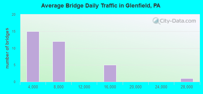
- 175,808Total average daily traffic
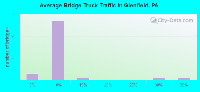
- 17,996Total average daily truck traffic
- National Bridge Inventory (NBI) Registered Bridges for Glenfield
- No street view available for this location
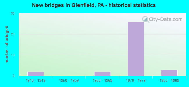
- New bridges - historical statistics
- 21940-1949
- 21960-1969
- 261970-1979
- 31980-1989
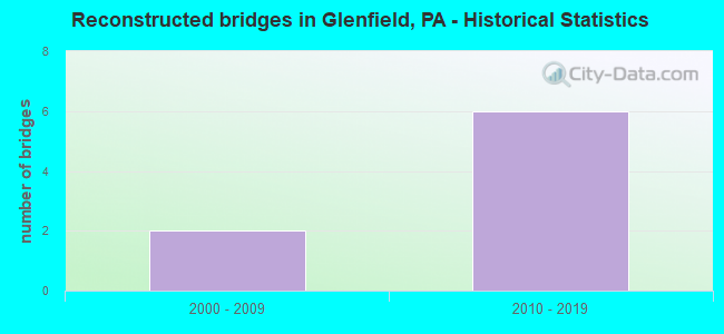
- Reconstructed bridges - Historical Statistics
- 22000-2009
- 62010-2019
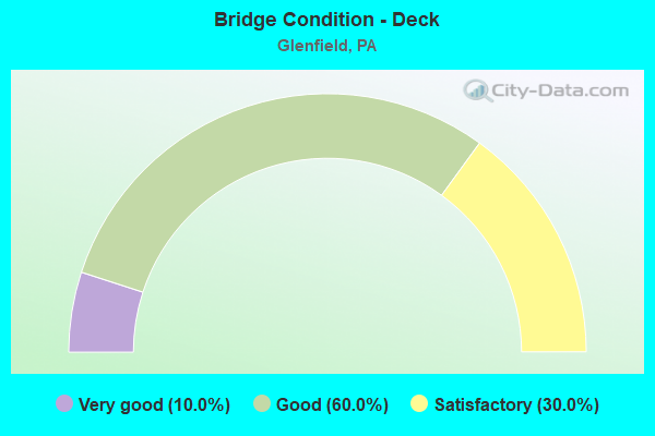
- Bridge Condition - Deck
- 10.0%Very good
- 60.0%Good
- 30.0%Satisfactory
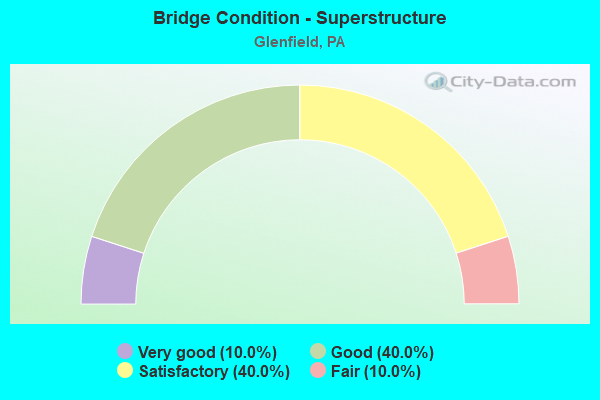
- Bridge Condition - Superstructure
- 10.0%Very good
- 40.0%Good
- 40.0%Satisfactory
- 10.0%Fair
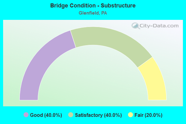
- Bridge Condition - Substructure
- 40.0%Good
- 40.0%Satisfactory
- 20.0%Fair
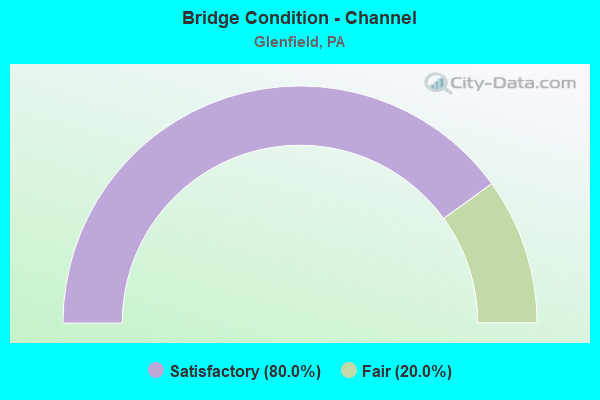
- Bridge Condition - Channel
- 80.0%Satisfactory
- 20.0%Fair
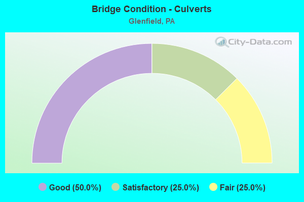
- Bridge Condition - Culverts
- 50.0%Good
- 25.0%Satisfactory
- 25.0%Fair
Find on map >> Show street view
Structure Number: 279, Location: 1/2 MI.N. OF MD. LINE (Lat: 39.728569, Lng: -77.256608), Route carried "on" structure: State highway , Year Built: 1949, Year Reconstructed: 2015, Status: Open, Structure Length: 2.96m (9.71ft), Average Daily Traffic: 342 (year 2022), Truck Traffic: 10%, Average Future Daily Traffic: 577 (year 2032), Design Load: HS 20, Features Intersected: MARSH CREEK, Facility Carried by Structure: SR 3002
Minimum Vertical Clearance: 30+ m (98+ ft), Kilometerpoint: 1.482, Lanes on structure: 2, Owner: State Highway Agency, Approaching Roadway Width: 6.7m (22.0ft), Material/Design: Steel continuous, Design/Construction: Stringer/Multi-beam, Number Of Spans In Main Unit: 2, Length of Maximum Span: 14.6m (47.9ft), Curb-To-Curb Width: 6.7m (22.0ft), Out-to-Out Width: 7.6m (24.9ft)
Condition: Deck: Very good, Superstructure: Very good, Substructure: Satisfactory, Channel: Satisfactory, Operating Rating: 94.3 metric tons, Method Used To Determine Operating Rating: Load Factor (LF), Inventory Rating: 56.2 metric tons, Method Used To Determine Inventory Rating: Load Factor (LF), Structural Evaluation: Equal to present minimum criteria, Deck Geometry: Meets minimum limits, Waterway Adequacy: Better than present minimum criteria, Approach Roadway Alignment: Equal to present desirable criteria, Length Of Structure Improvement: 3.00m (9.84ft), Designated Inspection Frequency: Every 24 months, Inspection Date: December 2020, Bridge Improvement Cost: $50,000, Roadway Improvement Cost: $148,000, Total Project Cost: $678,000, Deck Structure Type: Concrete Cast-file-Place, Wearing Surface/Protective System: Wearing Surface: Monolithic Concrete, Membrane: Other, Deck Protection: Epoxy Coated Reinforcing
Find on map >> Show street view
Structure Number: 843, Location: 1/4 MI. S.E. OF SR 0079 (Lat: 40.517997, Lng: -80.130906), Route carried "on" structure: State highway 65, Year Built: 1975, Year Reconstructed: 2010, Status: Open, Structure Length: 4.33m (14.21ft), Average Daily Traffic: 13,127 (year 2020), Truck Traffic: 7%, Average Future Daily Traffic: 15,183 (year 2032), Design Load: HS 20, Features Intersected: GLENFIELD ROAD, Facility Carried by Structure: OHIO RIVER BL
Minimum Vertical Clearance: 30+ m (98+ ft), Kilometerpoint: 12.392, Lanes on structure: 3, Lanes under structure: 2, Base Highway Network: Yes, Owner: State Highway Agency, Approaching Roadway Width: 16.2m (53.1ft), Skew: 1 degrees, Material/Design: Steel, Design/Construction: Stringer/Multi-beam, Number Of Spans In Main Unit: 1, Length of Maximum Span: 42.4m (139.1ft), Curb or Sidewalk Widths: Left: 0.2m (0.7ft), Right: 0.2m (0.7ft), Curb-To-Curb Width: 21.9m (71.9ft), Out-to-Out Width: 23.2m (76.1ft)
Condition: Deck: Good, Superstructure: Good, Substructure: Good, Operating Rating: 55.3 metric tons, Method Used To Determine Operating Rating: Load Factor (LF), Inventory Rating: 32.7 metric tons, Method Used To Determine Inventory Rating: Load Factor (LF), Structural Evaluation: Better than present minimum criteria, Deck Geometry: Superior to present desirable criteria, Underclear: High priority of corrective action, Approach Roadway Alignment: Equal to present desirable criteria, Length Of Structure Improvement: 4.20m (13.78ft), Designated Inspection Frequency: Every 24 months, Inspection Date: May 2021, Bridge Improvement Cost: $42,000, Roadway Improvement Cost: $123,000, Total Project Cost: $565,000, Deck Structure Type: Concrete Cast-file-Place, Wearing Surface/Protective System: Wearing Surface: Latex Concrete
Find on map >> Show street view
Structure Number: 844, Location: @ GLENFIELD I79 INTER-X (Lat: 40.518083, Lng: -80.131336), Route carried "on" structure: State highway 65, Year Built: 1941, Status: Open, Structure Length: 0.67m (2.20ft), Average Daily Traffic: 13,127 (year 2020), Truck Traffic: 7%, Average Future Daily Traffic: 15,183 (year 2032), Design Load: HS 20, Features Intersected: KILBUCK RUN, Facility Carried by Structure: OHIO RIVER BL
Minimum Vertical Clearance: 30+ m (98+ ft), Kilometerpoint: 12.392, Lanes on structure: 8, Base Highway Network: Yes, Owner: State Highway Agency, Approaching Roadway Width: 35.4m (116.1ft), Material/Design: Concrete, Design/Construction: Culvert, Number Of Spans In Main Unit: 1, Length of Maximum Span: 6.7m (22.0ft)
Condition: Channel: Satisfactory, Culverts: Fair, Operating Rating: 49.0 metric tons, Method Used To Determine Operating Rating: Field evaluation and documented engineering judgment, Inventory Rating: 32.7 metric tons, Method Used To Determine Inventory Rating: Field evaluation and documented engineering judgment, Structural Evaluation: Somewhat better than minimum adequacy, Waterway Adequacy: Superior to present desirable criteria, Approach Roadway Alignment: Equal to present desirable criteria, Length Of Structure Improvement: 0.70m (2.30ft), Designated Inspection Frequency: Every 24 months, Inspection Date: May 2021
Find on map >> Show street view
Structure Number: 901, Location: 0.4 MILES N OF SR 0065 (Lat: 40.521922, Lng: -80.131397), Route carried "on" structure: Interstate 79, Year Built: 1975, Year Reconstructed: 2008, Status: Open, Structure Length: 11.25m (36.91ft), Average Daily Traffic: 27,155 (year 2020), Truck Traffic: 31%, Average Future Daily Traffic: 39,913 (year 2032), Design Load: HS 20, Features Intersected: 8017 RAMP A & SR 4033, Facility Carried by Structure: RAYMOND SHAFER HW
Minimum Vertical Clearance: 30+ m (98+ ft), Kilometerpoint: 26.017, Lanes on structure: 4, Lanes under structure: 3, Base Highway Network: Yes, Owner: State Highway Agency, Approaching Roadway Width: 23.5m (77.1ft), Skew: 30 degrees, Material/Design: Steel continuous, Design/Construction: Girder and Floorbeam System, Number Of Spans In Main Unit: 4, Length of Maximum Span: 33.5m (109.9ft), Curb or Sidewalk Widths: Left: 0.2m (0.7ft), Right: 0.2m (0.7ft), Curb-To-Curb Width: 22.3m (73.2ft), Out-to-Out Width: 24.7m (81.0ft)
Condition: Deck: Good, Superstructure: Fair, Substructure: Fair, Operating Rating: 49.0 metric tons, Method Used To Determine Operating Rating: Load Factor (LF), Inventory Rating: 29.0 metric tons, Method Used To Determine Inventory Rating: Load Factor (LF), Structural Evaluation: Somewhat better than minimum adequacy, Deck Geometry: Superior to present desirable criteria, Underclear: High priority of corrective action, Approach Roadway Alignment: Equal to present desirable criteria, Length Of Structure Improvement: 11.20m (36.75ft), Designated Inspection Frequency: Every 24 months, Critical Feature Inspection Frequency: Every 24 months, Inspection Date: November 2020, Critical Feature Inspection Date: November 2020, Bridge Improvement Cost: $162,000, Roadway Improvement Cost: $476,000, Total Project Cost: $2,181,000, Deck Structure Type: Concrete Cast-file-Place, Wearing Surface/Protective System: Wearing Surface: Latex Concrete
Find on map >> Show street view
Structure Number: 1975, Location: 1055'N.OFINTER.W/SR65 (Lat: 40.520897, Lng: -80.130481), Route carried "on" structure: State highway , Year Built: 1976, Status: Open, Structure Length: 2.50m (8.20ft), Average Daily Traffic: 4,319 (year 2021), Truck Traffic: 6%, Average Future Daily Traffic: 4,181 (year 2038), Design Load: HS 20, Features Intersected: KILBUCK RUN, Facility Carried by Structure: GLENFIELD RD
Minimum Vertical Clearance: 30+ m (98+ ft), Kilometerpoint: 0.335, Lanes on structure: 2, Owner: State Highway Agency, Approaching Roadway Width: 11.0m (36.1ft), Skew: 7 degrees, Material/Design: Concrete, Design/Construction: Culvert, Number Of Spans In Main Unit: 1, Length of Maximum Span: 25.0m (82.0ft)
Condition: Channel: Fair, Culverts: Satisfactory, Operating Rating: 49.0 metric tons, Method Used To Determine Operating Rating: Field evaluation and documented engineering judgment, Inventory Rating: 32.7 metric tons, Method Used To Determine Inventory Rating: Field evaluation and documented engineering judgment, Structural Evaluation: Equal to present minimum criteria, Waterway Adequacy: Superior to present desirable criteria, Approach Roadway Alignment: Equal to present desirable criteria, Length Of Structure Improvement: 0.60m (1.97ft), Designated Inspection Frequency: Every 48 months, Inspection Date: June 2018
Find on map >> Show street view
Structure Number: 2027, Location: 1/2 MI.EAST OF SR 0079 (Lat: 40.518333, Lng: -80.131667), Route carried "on" structure: State highway , Year Built: 1988, Status: Open, Structure Length: 23.77m (77.99ft), Average Daily Traffic: 523 (year 2021), Truck Traffic: 26%, Average Future Daily Traffic: 863 (year 2032), Design Load: HS 20, Features Intersected: NSRR, SR 65, E. BEAV. ST, Facility Carried by Structure: GLENFIELD VIAD BR
Minimum Vertical Clearance: 30+ m (98+ ft), Kilometerpoint: 0.000, Lanes on structure: 2, Lanes under structure: 4, Owner: State Highway Agency, Approaching Roadway Width: 7.3m (24.0ft), Skew: 9 degrees, Material/Design: Steel continuous, Design/Construction: Stringer/Multi-beam, Number Of Spans In Main Unit: 3, Number Of Approach Spans: 7, Length of Maximum Span: 34.1m (111.9ft), Curb or Sidewalk Widths: Left: 0.2m (0.7ft), Right: 1.5m (4.9ft), Curb-To-Curb Width: 7.3m (24.0ft), Out-to-Out Width: 10.2m (33.5ft)
Condition: Deck: Satisfactory, Superstructure: Good, Substructure: Fair, Operating Rating: 68.0 metric tons, Method Used To Determine Operating Rating: Load Factor (LF), Inventory Rating: 40.8 metric tons, Method Used To Determine Inventory Rating: Load Factor (LF), Structural Evaluation: Somewhat better than minimum adequacy, Deck Geometry: Meets minimum limits, Underclear: High priority of corrective action, Approach Roadway Alignment: Equal to present minimum criteria, Length Of Structure Improvement: 24.30m (79.72ft), Designated Inspection Frequency: Every 24 months, Inspection Date: August 2021, Bridge Improvement Cost: $56,000, Roadway Improvement Cost: $165,000, Total Project Cost: $757,000, Deck Structure Type: Concrete Cast-file-Place, Wearing Surface/Protective System: Wearing Surface: Monolithic Concrete, Deck Protection: Epoxy Coated Reinforcing
Find on map >> Show street view
Structure Number: 2783, Location: RAMP TO SR 65 NB (Lat: 40.518333, Lng: -80.133333), Route carried "on" structure: Ramp State highway , Year Built: 1976, Year Reconstructed: 2010, Status: Open, Structure Length: 4.51m (14.80ft), Average Daily Traffic: 2,409 (year 2021), Truck Traffic: 7%, Average Future Daily Traffic: 1,799 (year 2032), Design Load: HS 20, Features Intersected: RAMP T TO SR 65 NB, Facility Carried by Structure: RAMP 8017 SB
Minimum Vertical Clearance: 4.47m (14.67ft), Kilometerpoint: 0.000, Lanes on structure: 1, Lanes under structure: 1, Base Highway Network: Yes, Owner: State Highway Agency, Approaching Roadway Width: 6.1m (20.0ft), Skew: 4 degrees, Material/Design: Steel, Design/Construction: Stringer/Multi-beam, Number Of Spans In Main Unit: 1, Length of Maximum Span: 43.9m (144.0ft), Curb or Sidewalk Widths: Left: 0.2m (0.7ft), Right: 1.8m (5.9ft), Curb-To-Curb Width: 6.1m (20.0ft), Out-to-Out Width: 8.8m (28.9ft)
Condition: Deck: Good, Superstructure: Good, Substructure: Good, Operating Rating: 93.4 metric tons, Method Used To Determine Operating Rating: Load Factor (LF), Inventory Rating: 55.3 metric tons, Method Used To Determine Inventory Rating: Load Factor (LF), Structural Evaluation: Better than present minimum criteria, Deck Geometry: High priority of corrective action, Underclear: High priority of corrective action, Approach Roadway Alignment: Equal to present desirable criteria, Length Of Structure Improvement: 5.50m (18.04ft), Designated Inspection Frequency: Every 24 months, Inspection Date: May 2020, Bridge Improvement Cost: $19,000, Roadway Improvement Cost: $57,000, Total Project Cost: $260,000, Deck Structure Type: Concrete Cast-file-Place, Wearing Surface/Protective System: Wearing Surface: Latex Concrete
Find on map >> Show street view
Structure Number: 2785, Location: I79 NB RAMP B TO SR 65 (Lat: 40.520000, Lng: -80.133333), Route carried "on" structure: Ramp State highway , Year Built: 1977, Year Reconstructed: 2008, Status: Open, Structure Length: 7.53m (24.70ft), Average Daily Traffic: 1,943 (year 2021), Truck Traffic: 7%, Average Future Daily Traffic: 3,877 (year 2032), Design Load: HS 20, Features Intersected: RAMP A, Facility Carried by Structure: RAMP B
Minimum Vertical Clearance: 30+ m (98+ ft), Kilometerpoint: 0.000, Lanes on structure: 1, Lanes under structure: 3, Base Highway Network: Yes, Owner: State Highway Agency, Approaching Roadway Width: 10.4m (34.1ft), Skew: 9 degrees, Material/Design: Steel continuous, Design/Construction: Girder and Floorbeam System, Number Of Spans In Main Unit: 4, Length of Maximum Span: 21.3m (69.9ft), Curb or Sidewalk Widths: Left: 0.2m (0.7ft), Right: 0.2m (0.7ft), Curb-To-Curb Width: 9.5m (31.2ft), Out-to-Out Width: 10.7m (35.1ft)
Condition: Deck: Satisfactory, Superstructure: Satisfactory, Substructure: Satisfactory, Operating Rating: 60.8 metric tons, Method Used To Determine Operating Rating: Load and Resistance Factor (LRFR), Inventory Rating: 46.3 metric tons, Method Used To Determine Inventory Rating: Load and Resistance Factor (LRFR), Structural Evaluation: Equal to present minimum criteria, Deck Geometry: Superior to present desirable criteria, Underclear: High priority of corrective action, Approach Roadway Alignment: Meets minimum limits, Length Of Structure Improvement: 7.50m (24.61ft), Designated Inspection Frequency: Every 24 months, Critical Feature Inspection Frequency: Every 24 months, Inspection Date: October 2020, Critical Feature Inspection Date: October 2020, Bridge Improvement Cost: $34,000, Roadway Improvement Cost: $101,000, Total Project Cost: $462,000, Deck Structure Type: Concrete Cast-file-Place, Wearing Surface/Protective System: Wearing Surface: Monolithic Concrete
Find on map >> Show street view
Structure Number: 2786, Location: RAMP B2 OVER RAMP A2 (Lat: 40.518769, Lng: -80.134553), Route carried "on" structure: Ramp State highway , Year Built: 1976, Year Reconstructed: 2010, Status: Open, Structure Length: 1.04m (3.41ft), Average Daily Traffic: 1,943 (year 2021), Truck Traffic: 7%, Average Future Daily Traffic: 3,877 (year 2032), Design Load: HS 20, Features Intersected: RAMP A2, Facility Carried by Structure: RAMP B2 (SR 8017)
Minimum Vertical Clearance: 30+ m (98+ ft), Kilometerpoint: 0.000, Lanes on structure: 1, Lanes under structure: 1, Base Highway Network: Yes, Owner: State Highway Agency, Approaching Roadway Width: 10.1m (33.1ft), Skew: 4 degrees, Material/Design: Concrete, Design/Construction: Frame, Number Of Spans In Main Unit: 1, Length of Maximum Span: 9.8m (32.2ft), Curb or Sidewalk Widths: Left: 0.2m (0.7ft), Right: 0.2m (0.7ft), Curb-To-Curb Width: 10.1m (33.1ft), Out-to-Out Width: 12.2m (40.0ft)
Condition: Deck: Good, Superstructure: Good, Substructure: Good, Operating Rating: 49.0 metric tons, Method Used To Determine Operating Rating: Field evaluation and documented engineering judgment, Inventory Rating: 32.7 metric tons, Method Used To Determine Inventory Rating: Field evaluation and documented engineering judgment, Structural Evaluation: Better than present minimum criteria, Deck Geometry: Superior to present desirable criteria, Underclear: High priority of corrective action, Approach Roadway Alignment: Equal to present desirable criteria, Length Of Structure Improvement: 1.00m (3.28ft), Designated Inspection Frequency: Every 24 months, Inspection Date: May 2020, Wearing Surface/Protective System: Wearing Surface: Bituminous
Find on map >> Show street view
Structure Number: 2788, Location: 1016 RAMP B2 OVER 02123 (Lat: 40.518400, Lng: -80.132356), Route carried "on" structure: Ramp State highway , Year Built: 1975, Year Reconstructed: 2010, Status: Open, Structure Length: 12.80m (41.99ft), Average Daily Traffic: 1,943 (year 2021), Truck Traffic: 7%, Average Future Daily Traffic: 3,877 (year 2032), Design Load: HS 20, Features Intersected: RAMP A1, Facility Carried by Structure: 79NB RAMP TO 65 NB
Minimum Vertical Clearance: 30+ m (98+ ft), Kilometerpoint: 0.000, Lanes on structure: 1, Lanes under structure: 6, Base Highway Network: Yes, Owner: State Highway Agency, Approaching Roadway Width: 8.2m (26.9ft), Material/Design: Steel continuous, Design/Construction: Girder and Floorbeam System, Number Of Spans In Main Unit: 3, Length of Maximum Span: 49.4m (162.1ft), Curb or Sidewalk Widths: Left: 0.2m (0.7ft), Right: 0.2m (0.7ft), Curb-To-Curb Width: 9.2m (30.2ft), Out-to-Out Width: 10.4m (34.1ft)
Condition: Deck: Good, Superstructure: Satisfactory, Substructure: Good, Operating Rating: 39.0 metric tons, Method Used To Determine Operating Rating: Load and Resistance Factor (LRFR), Inventory Rating: 29.9 metric tons, Method Used To Determine Inventory Rating: Load and Resistance Factor (LRFR), Structural Evaluation: Equal to present minimum criteria, Deck Geometry: Superior to present desirable criteria, Underclear: High priority of corrective action, Approach Roadway Alignment: Equal to present minimum criteria, Length Of Structure Improvement: 12.80m (41.99ft), Designated Inspection Frequency: Every 24 months, Critical Feature Inspection Frequency: Every 24 months, Inspection Date: October 2020, Critical Feature Inspection Date: October 2020, Bridge Improvement Cost: $67,000, Roadway Improvement Cost: $198,000, Total Project Cost: $907,000, Deck Structure Type: Concrete Cast-file-Place, Wearing Surface/Protective System: Wearing Surface: Latex Concrete
Find on map >> Show street view
Structure Number: 2789, Location: RAMP B1 GLENFIELD (Lat: 40.516667, Lng: -80.133333), Route carried "on" structure: Ramp State highway , Year Built: 1977, Year Reconstructed: 2010, Status: Open, Structure Length: 14.78m (48.49ft), Average Daily Traffic: 2,056 (year 2021), Truck Traffic: 7%, Average Future Daily Traffic: 4,004 (year 2032), Design Load: HS 20, Features Intersected: 65 NB-SB,RAMP A1,RAMP R, Facility Carried by Structure: RAMP B1
Minimum Vertical Clearance: 30+ m (98+ ft), Kilometerpoint: 0.000, Lanes on structure: 1, Lanes under structure: 8, Base Highway Network: Yes, Owner: State Highway Agency, Approaching Roadway Width: 10.1m (33.1ft), Skew: 9 degrees, Material/Design: Steel continuous, Design/Construction: Girder and Floorbeam System, Number Of Spans In Main Unit: 4, Length of Maximum Span: 45.7m (149.9ft), Curb or Sidewalk Widths: Left: 0.2m (0.7ft), Right: 0.2m (0.7ft), Curb-To-Curb Width: 9.2m (30.2ft), Out-to-Out Width: 10.4m (34.1ft)
Condition: Deck: Good, Superstructure: Satisfactory, Substructure: Satisfactory, Operating Rating: 55.3 metric tons, Method Used To Determine Operating Rating: Load and Resistance Factor (LRFR), Inventory Rating: 42.6 metric tons, Method Used To Determine Inventory Rating: Load and Resistance Factor (LRFR), Structural Evaluation: Equal to present minimum criteria, Deck Geometry: Superior to present desirable criteria, Underclear: Somewhat better than minimum adequacy, Approach Roadway Alignment: Better than present minimum criteria, Length Of Structure Improvement: 14.80m (48.56ft), Designated Inspection Frequency: Every 24 months, Critical Feature Inspection Frequency: Every 24 months, Inspection Date: October 2020, Critical Feature Inspection Date: October 2020, Bridge Improvement Cost: $41,000, Roadway Improvement Cost: $121,000, Total Project Cost: $555,000, Deck Structure Type: Concrete Cast-file-Place, Wearing Surface/Protective System: Wearing Surface: Latex Concrete
Find on map >> Show street view
Structure Number: 279, Location: RP.A OVER RP.B3-GLENFIELD (Lat: 40.516667, Lng: -80.133333), Route carried "on" structure: Ramp State highway , Year Built: 1975, Status: Open, Structure Length: 4.91m (16.11ft), Average Daily Traffic: 4,639 (year 2021), Truck Traffic: 7%, Average Future Daily Traffic: 3,823 (year 2032), Design Load: HS 20, Features Intersected: RAMP B-3, Facility Carried by Structure: RAMP A
Minimum Vertical Clearance: 30+ m (98+ ft), Kilometerpoint: 0.000, Lanes on structure: 1, Lanes under structure: 1, Base Highway Network: Yes, Owner: State Highway Agency, Approaching Roadway Width: 10.1m (33.1ft), Skew: 9 degrees, Material/Design: Steel continuous, Design/Construction: Girder and Floorbeam System, Number Of Spans In Main Unit: 3, Length of Maximum Span: 23.5m (77.1ft), Curb or Sidewalk Widths: Left: 0.2m (0.7ft), Right: 0.2m (0.7ft), Curb-To-Curb Width: 9.5m (31.2ft), Out-to-Out Width: 10.8m (35.4ft)
Condition: Deck: Satisfactory, Superstructure: Satisfactory, Substructure: Satisfactory, Operating Rating: 58.1 metric tons, Method Used To Determine Operating Rating: Load and Resistance Factor (LRFR), Inventory Rating: 44.5 metric tons, Method Used To Determine Inventory Rating: Load and Resistance Factor (LRFR), Structural Evaluation: Equal to present minimum criteria, Deck Geometry: Superior to present desirable criteria, Underclear: High priority of corrective action, Approach Roadway Alignment: Equal to present minimum criteria, Length Of Structure Improvement: 4.90m (16.08ft), Designated Inspection Frequency: Every 24 months, Critical Feature Inspection Frequency: Every 24 months, Inspection Date: August 2021, Critical Feature Inspection Date: August 2021, Bridge Improvement Cost: $23,000, Roadway Improvement Cost: $66,000, Total Project Cost: $305,000, Deck Structure Type: Concrete Cast-file-Place, Wearing Surface/Protective System: Wearing Surface: Monolithic Concrete
Find on map >> Show street view
Structure Number: 2792, Location: 50'EAST OF SR 4005 (Lat: 40.529164, Lng: -80.129444), Route carried "on" structure: Ramp State highway , Year Built: 1969, Status: Open, Structure Length: 0.67m (2.20ft), Average Daily Traffic: 3,057 (year 2021), Truck Traffic: 7%, Average Future Daily Traffic: 3,639 (year 2032), Design Load: HS 20, Features Intersected: KILBUCK RUN, Facility Carried by Structure: RAMP C
Minimum Vertical Clearance: 30+ m (98+ ft), Kilometerpoint: 0.000, Lanes on structure: 1, Base Highway Network: Yes, Owner: State Highway Agency, Approaching Roadway Width: 10.1m (33.1ft), Skew: 4 degrees, Material/Design: Concrete, Design/Construction: Culvert, Number Of Spans In Main Unit: 1, Length of Maximum Span: 6.7m (22.0ft)
Condition: Channel: Satisfactory, Culverts: Good, Inventory Rating: 99.8 metric tons, Method Used To Determine Inventory Rating: Load Factor (LF), Structural Evaluation: Better than present minimum criteria, Waterway Adequacy: Superior to present desirable criteria, Approach Roadway Alignment: Equal to present desirable criteria, Length Of Structure Improvement: 0.70m (2.30ft), Designated Inspection Frequency: Every 48 months, Inspection Date: May 2018
Find on map >> Show street view
Structure Number: 2793, Location: @ INTERSECTION W/SR 4005 (Lat: 40.526606, Lng: -80.129769), Route carried "on" structure: Ramp State highway , Year Built: 1969, Status: Open, Structure Length: 0.67m (2.20ft), Average Daily Traffic: 3,413 (year 2021), Truck Traffic: 7%, Average Future Daily Traffic: 3,817 (year 2032), Design Load: HS 20, Features Intersected: KILBUCK RUN, Facility Carried by Structure: RAMP D
Minimum Vertical Clearance: 30+ m (98+ ft), Kilometerpoint: 0.000, Lanes on structure: 1, Base Highway Network: Yes, Owner: State Highway Agency, Approaching Roadway Width: 13.4m (44.0ft), Skew: 5 degrees, Material/Design: Concrete, Design/Construction: Culvert, Number Of Spans In Main Unit: 1, Length of Maximum Span: 6.7m (22.0ft)
Condition: Channel: Satisfactory, Culverts: Good, Operating Rating: 78.9 metric tons, Method Used To Determine Operating Rating: Field evaluation and documented engineering judgment, Inventory Rating: 47.2 metric tons, Method Used To Determine Inventory Rating: Field evaluation and documented engineering judgment, Structural Evaluation: Better than present minimum criteria, Waterway Adequacy: Superior to present desirable criteria, Approach Roadway Alignment: Equal to present desirable criteria, Length Of Structure Improvement: 0.70m (2.30ft), Designated Inspection Frequency: Every 24 months, Inspection Date: May 2020
Find on map >> Show street view
Structure Number: 843, Location: 1/4 MI. S.E. OF SR 0079 (Lat: 40.517997, Lng: -80.130906), Route carried "under" structure: State highway , Year Built: 1975, Structure Length: 0. m, Average Daily Traffic: 4,319 (year 2021), Truck Traffic: 6%, Features Intersected: GLENFIELD ROAD, Facility Carried by Structure: OHIO RIVER BL
Minimum Vertical Clearance: 4.19m (13.75ft), Kilometerpoint: 0.335, Lanes on structure: 3, Lanes under structure: 2, Material/Design: Steel, Design/Construction: Stringer/Multi-beam, Length of Maximum Span: 42.4m (139.1ft)
Find on map >> Show street view
Structure Number: 901, Location: 0.4 MILES N OF SR 0065 (Lat: 40.521922, Lng: -80.131397), Route carried "under" structure: State highway , Year Built: 1975, Structure Length: 0. m, Average Daily Traffic: 4,319 (year 2021), Truck Traffic: 6%, Features Intersected: 8017 RAMP A & SR 4033, Facility Carried by Structure: RAYMOND SHAFER HW
Minimum Vertical Clearance: 9.98m (32.74ft), Kilometerpoint: 0.335, Lanes on structure: 4, Lanes under structure: 2, Material/Design: Steel continuous, Design/Construction: Girder and Floorbeam System, Length of Maximum Span: 33.5m (109.9ft)
Find on map >> Show street view
Structure Number: 901, Location: 0.4 MILES N OF SR 0065 (Lat: 40.521922, Lng: -80.131397), Route carried "under" structure: Ramp State highway , Year Built: 1975, Structure Length: 0. m, Average Daily Traffic: 4,639 (year 2021), Truck Traffic: 7%, Features Intersected: 8017 RAMP A & SR 4033, Facility Carried by Structure: RAYMOND SHAFER HW
Minimum Vertical Clearance: 4.39m (14.40ft), Kilometerpoint: 0.000, Lanes on structure: 4, Lanes under structure: 1, Material/Design: Steel continuous, Design/Construction: Girder and Floorbeam System, Length of Maximum Span: 33.5m (109.9ft)
Find on map >> Show street view
Structure Number: 902, Location: SR79 NB OVER GLENFIELD RD (Lat: 40.528544, Lng: -80.129114), Route carried "under" structure: County highway , Year Built: 1971, Structure Length: 0. m, Average Daily Traffic: 5,724 (year 2005), Truck Traffic: 4%, Features Intersected: GLENFIELD RD,KILBUCK RUN, Facility Carried by Structure: RAYMOND SHAFER HW
Minimum Vertical Clearance: 8.36m (27.43ft), Kilometerpoint: 0.000, Lanes on structure: 2, Lanes under structure: 2, Material/Design: Steel, Design/Construction: Stringer/Multi-beam, Length of Maximum Span: 32.9m (107.9ft)
Find on map >> Show street view
Structure Number: 903, Location: 79 SB OVER GLENFIELD RD (Lat: 40.525286, Lng: -80.130953), Route carried "under" structure: County highway , Year Built: 1971, Structure Length: 0. m, Average Daily Traffic: 5,000 (year 2005), Truck Traffic: 3%, Features Intersected: GLENFIELD RD,KILBUCK RUN, Facility Carried by Structure: RAYMOND SHAFER HW
Minimum Vertical Clearance: 7.82m (25.66ft), Kilometerpoint: 0.000, Lanes on structure: 2, Lanes under structure: 2, Material/Design: Steel, Design/Construction: Stringer/Multi-beam, Length of Maximum Span: 34.7m (113.8ft)
Find on map >> Show street view
Structure Number: 2027, Location: 1/2 MI.EAST OF SR 0079 (Lat: 40.518333, Lng: -80.131667), Route carried "under" structure: City street , Year Built: 1988, Structure Length: 0. m, Average Daily Traffic: 150 (year 2019), Truck Traffic: 1%, Features Intersected: NSRR, SR 65, E. BEAV. ST, Facility Carried by Structure: GLENFIELD VIAD BR
Minimum Vertical Clearance: 10.97m (35.99ft), Kilometerpoint: 0.000, Lanes on structure: 2, Lanes under structure: 2, Material/Design: Steel continuous, Design/Construction: Stringer/Multi-beam, Length of Maximum Span: 34.1m (111.9ft)
Find on map >> Show street view
Structure Number: 2027, Location: 1/2 MI.EAST OF SR 0079 (Lat: 40.518333, Lng: -80.131667), Route carried "under" structure: State highway 65, Year Built: 1988, Structure Length: 0. m, Average Daily Traffic: 13,930 (year 2020), Truck Traffic: 6%, Features Intersected: NSRR, SR 65, E. BEAV. ST, Facility Carried by Structure: GLENFIELD VIAD BR
Minimum Vertical Clearance: 6.46m (21.19ft), Kilometerpoint: 12.529, Lanes on structure: 2, Lanes under structure: 2, Material/Design: Steel continuous, Design/Construction: Stringer/Multi-beam, Length of Maximum Span: 34.1m (111.9ft)
Find on map >> Show street view
Structure Number: 278, Location: Neville Island Bridge (Lat: 40.512644, Lng: -80.135494), Route carried "under" structure: County highway , Year Built: 1973, Structure Length: 0. m, Average Daily Traffic: 4,000 (year 2004), Truck Traffic: 5%, Features Intersected: MAINT. YARD, GRAND AVE, Facility Carried by Structure: RAMP J
Minimum Vertical Clearance: 12.58m (41.27ft), Kilometerpoint: 0.000, Lanes on structure: 1, Lanes under structure: 4, Material/Design: Steel continuous, Design/Construction: Girder and Floorbeam System, Length of Maximum Span: 37.5m (123.0ft)
Find on map >> Show street view
Structure Number: 2783, Location: RAMP TO SR 65 NB (Lat: 40.518333, Lng: -80.133333), Route carried "under" structure: Ramp State highway , Year Built: 1976, Structure Length: 0. m, Average Daily Traffic: 2,276 (year 2021), Truck Traffic: 7%, Features Intersected: RAMP T TO SR 65 NB, Facility Carried by Structure: RAMP 8017 SB
Minimum Vertical Clearance: 4.57m (14.99ft), Kilometerpoint: 0.000, Lanes on structure: 1, Lanes under structure: 1, Material/Design: Steel, Design/Construction: Stringer/Multi-beam, Length of Maximum Span: 43.9m (144.0ft)
Find on map >> Show street view
Structure Number: 2785, Location: I79 NB RAMP B TO SR 65 (Lat: 40.520000, Lng: -80.133333), Route carried "under" structure: State highway , Year Built: 1977, Structure Length: 0. m, Average Daily Traffic: 4,319 (year 2021), Truck Traffic: 6%, Features Intersected: RAMP A, Facility Carried by Structure: RAMP B
Minimum Vertical Clearance: 7.77m (25.49ft), Kilometerpoint: 0.335, Lanes on structure: 1, Lanes under structure: 2, Material/Design: Steel continuous, Design/Construction: Girder and Floorbeam System, Length of Maximum Span: 21.3m (69.9ft)
Find on map >> Show street view
Structure Number: 2785, Location: I79 NB RAMP B TO SR 65 (Lat: 40.520000, Lng: -80.133333), Route carried "under" structure: Ramp State highway , Year Built: 1977, Structure Length: 0. m, Average Daily Traffic: 4,639 (year 2021), Truck Traffic: 7%, Features Intersected: RAMP A, Facility Carried by Structure: RAMP B
Minimum Vertical Clearance: 4.47m (14.67ft), Kilometerpoint: 0.000, Lanes on structure: 1, Lanes under structure: 1, Material/Design: Steel continuous, Design/Construction: Girder and Floorbeam System, Length of Maximum Span: 21.3m (69.9ft)
Find on map >> Show street view
Structure Number: 2786, Location: RAMP B2 OVER RAMP A2 (Lat: 40.518769, Lng: -80.134553), Route carried "under" structure: Ramp State highway , Year Built: 1976, Structure Length: 0. m, Average Daily Traffic: 2,276 (year 2021), Truck Traffic: 7%, Features Intersected: RAMP A2, Facility Carried by Structure: RAMP B2 (SR 8017)
Minimum Vertical Clearance: 4.50m (14.76ft), Kilometerpoint: 0.000, Lanes on structure: 1, Lanes under structure: 1, Material/Design: Concrete, Design/Construction: Frame, Length of Maximum Span: 9.8m (32.2ft)
Find on map >> Show street view
Structure Number: 2788, Location: 1016 RAMP B2 OVER 02123 (Lat: 40.518400, Lng: -80.132356), Route carried "under" structure: State highway , Year Built: 1975, Structure Length: 0. m, Average Daily Traffic: 4,319 (year 2021), Truck Traffic: 6%, Features Intersected: RAMP A1, Facility Carried by Structure: 79NB RAMP TO 65 NB
Minimum Vertical Clearance: 9.14m (29.99ft), Kilometerpoint: 0.335, Lanes on structure: 1, Lanes under structure: 3, Material/Design: Steel continuous, Design/Construction: Girder and Floorbeam System, Length of Maximum Span: 49.4m (162.1ft)
Find on map >> Show street view
Structure Number: 2788, Location: 1016 RAMP B2 OVER 02123 (Lat: 40.518400, Lng: -80.132356), Route carried "under" structure: Ramp State highway , Year Built: 1975, Structure Length: 0. m, Average Daily Traffic: 4,639 (year 2021), Truck Traffic: 7%, Features Intersected: RAMP A1, Facility Carried by Structure: 79NB RAMP TO 65 NB
Minimum Vertical Clearance: 4.70m (15.42ft), Kilometerpoint: 0.000, Lanes on structure: 1, Lanes under structure: 3, Material/Design: Steel continuous, Design/Construction: Girder and Floorbeam System, Length of Maximum Span: 49.4m (162.1ft)
Find on map >> Show street view
Structure Number: 2789, Location: RAMP B1 GLENFIELD (Lat: 40.516667, Lng: -80.133333), Route carried "under" structure: Ramp State highway , Year Built: 1977, Structure Length: 0. m, Average Daily Traffic: 1,692 (year 2022), Truck Traffic: 9%, Features Intersected: 65 NB-SB,RAMP A1,RAMP R, Facility Carried by Structure: RAMP B1
Minimum Vertical Clearance: 8.99m (29.49ft), Kilometerpoint: 0.000, Lanes on structure: 1, Lanes under structure: 3, Material/Design: Steel continuous, Design/Construction: Girder and Floorbeam System, Length of Maximum Span: 45.7m (149.9ft)
Find on map >> Show street view
Structure Number: 2789, Location: RAMP B1 GLENFIELD (Lat: 40.516667, Lng: -80.133333), Route carried "under" structure: State highway 65, Year Built: 1977, Structure Length: 0. m, Average Daily Traffic: 13,127 (year 2020), Truck Traffic: 7%, Features Intersected: 65 NB-SB,RAMP A1,RAMP R, Facility Carried by Structure: RAMP B1
Minimum Vertical Clearance: 5.13m (16.83ft), Kilometerpoint: 12.392, Lanes on structure: 1, Lanes under structure: 2, Material/Design: Steel continuous, Design/Construction: Girder and Floorbeam System, Length of Maximum Span: 45.7m (149.9ft)
Find on map >> Show street view
Structure Number: 2789, Location: RAMP B1 GLENFIELD (Lat: 40.516667, Lng: -80.133333), Route carried "under" structure: Ramp State highway , Year Built: 1977, Structure Length: 0. m, Average Daily Traffic: 842 (year 2021), Truck Traffic: 7%, Features Intersected: 65 NB-SB,RAMP A1,RAMP R, Facility Carried by Structure: RAMP B1
Minimum Vertical Clearance: 5.52m (18.11ft), Kilometerpoint: 0.000, Lanes on structure: 1, Lanes under structure: 1, Material/Design: Steel continuous, Design/Construction: Girder and Floorbeam System, Length of Maximum Span: 45.7m (149.9ft)
Find on map >> Show street view
Structure Number: 2789, Location: RAMP B1 GLENFIELD (Lat: 40.516667, Lng: -80.133333), Route carried "under" structure: State highway 65, Year Built: 1977, Structure Length: 0. m, Average Daily Traffic: 13,930 (year 2020), Truck Traffic: 6%, Features Intersected: 65 NB-SB,RAMP A1,RAMP R, Facility Carried by Structure: RAMP B1
Minimum Vertical Clearance: 6.99m (22.93ft), Kilometerpoint: 12.529, Lanes on structure: 1, Lanes under structure: 2, Material/Design: Steel continuous, Design/Construction: Girder and Floorbeam System, Length of Maximum Span: 45.7m (149.9ft)
Find on map >> Show street view
Structure Number: 279, Location: RP.A OVER RP.B3-GLENFIELD (Lat: 40.516667, Lng: -80.133333), Route carried "under" structure: Ramp State highway , Year Built: 1975, Structure Length: 0. m, Average Daily Traffic: 1,672 (year 2021), Truck Traffic: 7%, Features Intersected: RAMP B-3, Facility Carried by Structure: RAMP A
Minimum Vertical Clearance: 4.40m (14.44ft), Kilometerpoint: 0.000, Lanes on structure: 1, Lanes under structure: 1, Material/Design: Steel continuous, Design/Construction: Girder and Floorbeam System, Length of Maximum Span: 23.5m (77.1ft)