Bridge Statistics for Grand Prairie, Texas (TX)
Condition, Traffic, Stress, Structural Evaluation, Project Costs
- National Bridge Inventory (NBI) Statistics
- 346Number of bridges
- 11,932ft / 3,637mTotal length
- $667,000Total costs
- 7,358,092Total average daily traffic
- 407,803Total average daily truck traffic
- National Bridge Inventory (NBI) Registered Bridges for Grand Prairie
- No street view available for this location
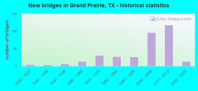
- New bridges - historical statistics
- 51930-1939
- 41940-1949
- 71950-1959
- 141960-1969
- 311970-1979
- 281980-1989
- 271990-1999
- 972000-2009
- 1192010-2019
- 142020-2022
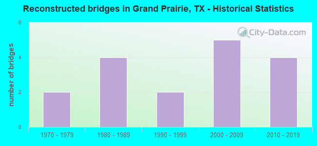
- Reconstructed bridges - Historical Statistics
- 21970-1979
- 41980-1989
- 21990-1999
- 52000-2009
- 42010-2019
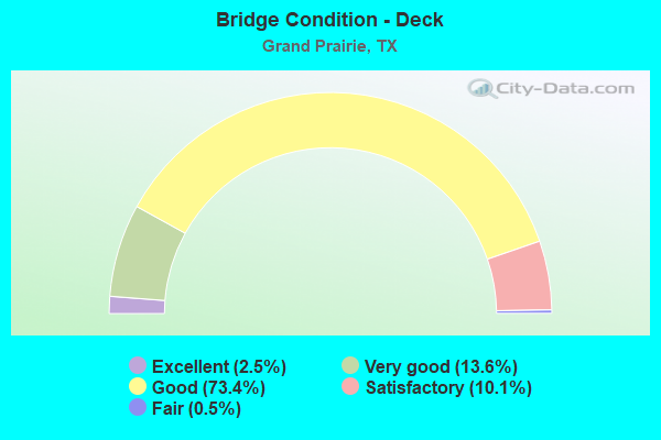
- Bridge Condition - Deck
- 2.5%Excellent
- 13.6%Very good
- 73.4%Good
- 10.1%Satisfactory
- 0.5%Fair
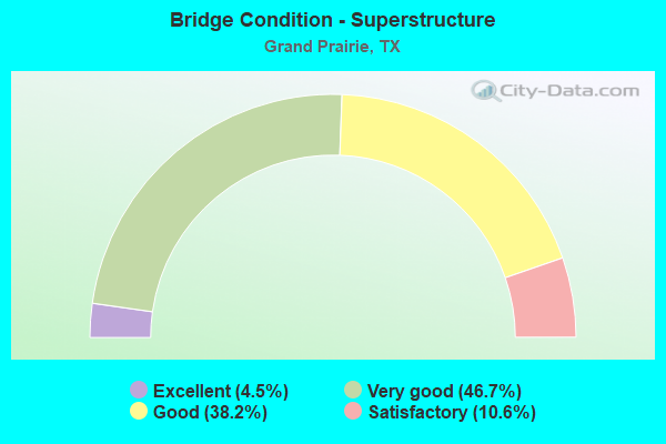
- Bridge Condition - Superstructure
- 4.5%Excellent
- 46.7%Very good
- 38.2%Good
- 10.6%Satisfactory
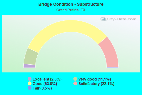
- Bridge Condition - Substructure
- 2.5%Excellent
- 11.1%Very good
- 63.8%Good
- 22.1%Satisfactory
- 0.5%Fair
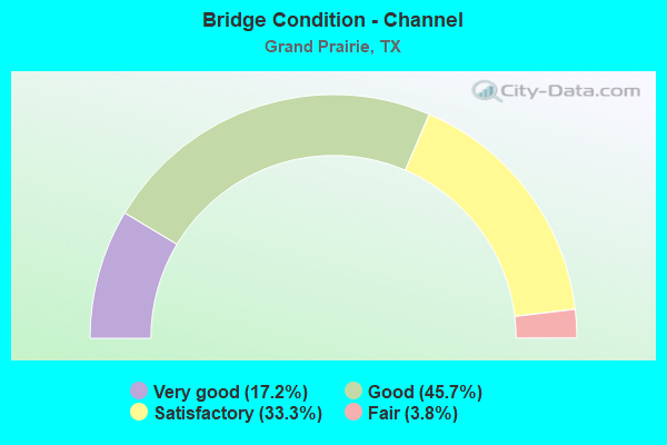
- Bridge Condition - Channel
- 17.2%Very good
- 45.7%Good
- 33.3%Satisfactory
- 3.8%Fair
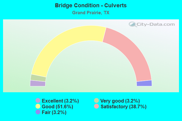
- Bridge Condition - Culverts
- 3.2%Excellent
- 3.2%Very good
- 51.6%Good
- 38.7%Satisfactory
- 3.2%Fair
Find on map >> Show street view
Structure Number: 22200106802307, Location: 1.5 MI E OF SH-360 (Lat: 32.759522, Lng: -97.037025), Route carried "on" structure: City street , Year Built: 2009, Status: Open, Structure Length: 10.09m (33.10ft), Average Daily Traffic: 5,410 (year 2009), Average Future Daily Traffic: 5,460 (year 2029), Design Load: HS 20, Features Intersected: IH 30, Facility Carried by Structure: DUNCAN-PERRY ROAD
Minimum Vertical Clearance: 30+ m (98+ ft), Kilometerpoint: 1.690, Lanes on structure: 4, Lanes under structure: 10, Owner: State Highway Agency, Approaching Roadway Width: 15.2m (49.9ft), Material/Design: Prestressed concrete, Design/Construction: Stringer/Multi-beam, Number Of Spans In Main Unit: 2, Number Of Approach Spans: 2, Length of Maximum Span: 35.1m (115.2ft), Curb or Sidewalk Widths: Left: 1.8m (5.9ft), Right: 2.4m (7.9ft), Curb-To-Curb Width: 15.2m (49.9ft), Out-to-Out Width: 20.7m (67.9ft)
Condition: Deck: Very good, Superstructure: Very good, Substructure: Satisfactory, Operating Rating: 54.4 metric tons, Method Used To Determine Operating Rating: Assigned rating based on Load Factor Design (LFD) reported in metric tons, Inventory Rating: 32.7 metric tons, Method Used To Determine Inventory Rating: Assigned rating based on Load Factor Design (LFD) reported in metric tons, Structural Evaluation: Equal to present minimum criteria, Deck Geometry: High priority of corrective action, Underclear: High priority of corrective action, Approach Roadway Alignment: Equal to present desirable criteria, Length Of Structure Improvement: 10.09m (33.10ft), Designated Inspection Frequency: Every 24 months, Inspection Date: June 2021, Bridge Improvement Cost: $33,000, Roadway Improvement Cost: $8,000, Total Project Cost: $41,000, Deck Structure Type: Concrete Cast-file-Place, Wearing Surface/Protective System: Deck Protection: Epoxy Coated Reinforcing
Find on map >> Show street view
Structure Number: 2220022080101, Location: 1.2 MI E OF SH-360 (Lat: 32.711206, Lng: -97.039631), Route carried "on" structure: Spur State highway 303, Year Built: 1967, Year Reconstructed: 2017, Status: Open, Structure Length: 1.74m (5.71ft), Average Daily Traffic: 19,700 (year 2020), Truck Traffic: 5%, Average Future Daily Traffic: 27,120 (year 2033), Features Intersected: TRIB OF COTTONWOOD CREEK
Minimum Vertical Clearance: 30+ m (98+ ft), Kilometerpoint: 35.163, Lanes on structure: 7, Owner: State Highway Agency, Approaching Roadway Width: 25.6m (84.0ft), Skew: 34 degrees, Material/Design: Concrete, Design/Construction: Culvert, Number Of Spans In Main Unit: 4, Length of Maximum Span: 3.7m (12.1ft)
Condition: Channel: Satisfactory, Culverts: Satisfactory, Operating Rating: 39.9 metric tons, Method Used To Determine Operating Rating: Load Factor (LF), Inventory Rating: 23.6 metric tons, Method Used To Determine Inventory Rating: Load Factor (LF), Structural Evaluation: Somewhat better than minimum adequacy, Waterway Adequacy: Equal to present minimum criteria, Approach Roadway Alignment: Equal to present desirable criteria, Designated Inspection Frequency: Every 24 months, Inspection Date: May 2021
Find on map >> Show street view
Structure Number: 22200226602002, Location: 2.2 MI S OF SH-183 (Lat: 32.805308, Lng: -97.053517), Route carried "on" structure: State highway 360, Year Built: 1958, Year Reconstructed: 1987, Status: Open, Structure Length: 11.83m (38.81ft), Average Daily Traffic: 60,859 (year 2019), Truck Traffic: 5%, Average Future Daily Traffic: 93,220 (year 2033), Design Load: H 20, Features Intersected: RIVERSIDE PARKWAY
Minimum Vertical Clearance: 30+ m (98+ ft), Kilometerpoint: 13.145, Lanes on structure: 3, Lanes under structure: 7, Base Highway Network: Yes, Owner: State Highway Agency, Approaching Roadway Width: 17.1m (56.1ft), Material/Design: Prestressed concrete, Design/Construction: Stringer/Multi-beam, Number Of Spans In Main Unit: 6, Length of Maximum Span: 19.8m (65.0ft), Curb-To-Curb Width: 17.1m (56.1ft), Out-to-Out Width: 18.0m (59.1ft)
Condition: Deck: Good, Superstructure: Good, Substructure: Good, Operating Rating: 67.1 metric tons, Method Used To Determine Operating Rating: Load Factor (LF), Inventory Rating: 32.7 metric tons, Method Used To Determine Inventory Rating: Load Factor (LF), Structural Evaluation: Better than present minimum criteria, Deck Geometry: Equal to present minimum criteria, Underclear: Equal to present minimum criteria, Approach Roadway Alignment: Equal to present desirable criteria, Designated Inspection Frequency: Every 24 months, Inspection Date: June 2021, Deck Structure Type: Concrete Cast-file-Place
Find on map >> Show street view
Structure Number: 22200226602012, Location: 1.1 MI S OF IH-20 (Lat: 32.660883, Lng: -97.062314), Route carried "on" structure: State highway 360, Year Built: 2006, Status: Open, Structure Length: 19.05m (62.50ft), Average Daily Traffic: 42,990 (year 2019), Truck Traffic: 1%, Average Future Daily Traffic: 62,500 (year 2029), Design Load: HS 20, Features Intersected: SE GREEN OAKS/FISH CREEK
Minimum Vertical Clearance: 30+ m (98+ ft), Kilometerpoint: 29.237, Lanes on structure: 2, Lanes under structure: 9, Base Highway Network: Yes, Owner: State Highway Agency, Approaching Roadway Width: 13.4m (44.0ft), Skew: 4 degrees, Material/Design: Steel continuous, Design/Construction: Stringer/Multi-beam, Number Of Spans In Main Unit: 1, Number Of Approach Spans: 2, Length of Maximum Span: 80.8m (265.1ft), Curb-To-Curb Width: 13.2m (43.3ft), Out-to-Out Width: 14.0m (45.9ft)
Condition: Deck: Good, Superstructure: Good, Substructure: Good, Channel: Very good, Operating Rating: 68.0 metric tons, Method Used To Determine Operating Rating: Load Factor (LF), Inventory Rating: 40.8 metric tons, Method Used To Determine Inventory Rating: Load Factor (LF), Structural Evaluation: Better than present minimum criteria, Deck Geometry: Superior to present desirable criteria, Underclear: Meets minimum limits, Waterway Adequacy: Superior to present desirable criteria, Approach Roadway Alignment: Equal to present desirable criteria, Designated Inspection Frequency: Every 24 months, Inspection Date: June 2021, Deck Structure Type: Concrete Precast Panels, Wearing Surface/Protective System: Membrane: Other, Deck Protection: Epoxy Coated Reinforcing
Find on map >> Show street view
Structure Number: 22200226602019, Location: 2.2 MI S OF SH-183 (Lat: 32.805308, Lng: -97.053631), Route carried "on" structure: State highway 360, Year Built: 1973, Year Reconstructed: 1986, Status: Open, Structure Length: 11.83m (38.81ft), Average Daily Traffic: 68,668 (year 2019), Truck Traffic: 5%, Average Future Daily Traffic: 93,220 (year 2033), Design Load: HS 20, Features Intersected: RIVERSIDE PARKWAY
Minimum Vertical Clearance: 30+ m (98+ ft), Kilometerpoint: 13.145, Lanes on structure: 3, Lanes under structure: 7, Base Highway Network: Yes, Owner: State Highway Agency, Approaching Roadway Width: 17.7m (58.1ft), Material/Design: Prestressed concrete, Design/Construction: Stringer/Multi-beam, Number Of Spans In Main Unit: 6, Length of Maximum Span: 19.8m (65.0ft), Curb-To-Curb Width: 17.7m (58.1ft), Out-to-Out Width: 18.6m (61.0ft)
Condition: Deck: Very good, Superstructure: Satisfactory, Substructure: Good, Operating Rating: 54.4 metric tons, Method Used To Determine Operating Rating: Assigned rating based on Load Factor Design (LFD) reported in metric tons, Inventory Rating: 32.7 metric tons, Method Used To Determine Inventory Rating: Assigned rating based on Load Factor Design (LFD) reported in metric tons, Structural Evaluation: Equal to present minimum criteria, Deck Geometry: Better than present minimum criteria, Underclear: Somewhat better than minimum adequacy, Approach Roadway Alignment: Equal to present desirable criteria, Designated Inspection Frequency: Every 24 months, Inspection Date: June 2021, Deck Structure Type: Concrete Cast-file-Place, Wearing Surface/Protective System: Wearing Surface: Bituminous
Find on map >> Show street view
Structure Number: 22200226602046, Location: 3.16 MI S OF SH 183 (Lat: 32.793364, Lng: -97.056697), Route carried "on" structure: City street , Year Built: 1986, Status: Open, Structure Length: 5.03m (16.50ft), Average Daily Traffic: 9,790 (year 2009), Average Future Daily Traffic: 9,840 (year 2029), Design Load: HS 20, Features Intersected: SH-360, Facility Carried by Structure: POST & PADDOCK RD
Minimum Vertical Clearance: 30+ m (98+ ft), Kilometerpoint: 0.805, Lanes on structure: 6, Lanes under structure: 6, Owner: State Highway Agency, Approaching Roadway Width: 23.2m (76.1ft), Skew: 1 degrees, Material/Design: Prestressed concrete, Design/Construction: Stringer/Multi-beam, Number Of Spans In Main Unit: 2, Length of Maximum Span: 25.0m (82.0ft), Curb or Sidewalk Widths: Left: 1.8m (5.9ft), Right: 1.8m (5.9ft), Curb-To-Curb Width: 23.2m (76.1ft), Out-to-Out Width: 27.4m (89.9ft)
Condition: Deck: Good, Superstructure: Very good, Substructure: Good, Operating Rating: 54.4 metric tons, Method Used To Determine Operating Rating: Assigned rating based on Load Factor Design (LFD) reported in metric tons, Inventory Rating: 32.7 metric tons, Method Used To Determine Inventory Rating: Assigned rating based on Load Factor Design (LFD) reported in metric tons, Structural Evaluation: Better than present minimum criteria, Deck Geometry: Meets minimum limits, Underclear: Equal to present minimum criteria, Approach Roadway Alignment: Equal to present desirable criteria, Designated Inspection Frequency: Every 24 months, Inspection Date: June 2021, Deck Structure Type: Concrete Cast-file-Place
Find on map >> Show street view
Structure Number: 22200226602047, Location: 3.73 MI S OF SH 183 (Lat: 32.785361, Lng: -97.059042), Route carried "on" structure: City street 300, Year Built: 1986, Status: Open, Structure Length: 7.62m (25.00ft), Average Daily Traffic: 16,691 (year 2019), Average Future Daily Traffic: 4,715 (year 2029), Design Load: HS 20, Features Intersected: SH-360, Facility Carried by Structure: W N. CARRIER PKWY
Minimum Vertical Clearance: 30+ m (98+ ft), Kilometerpoint: 1.609, Lanes on structure: 6, Lanes under structure: 7, Owner: State Highway Agency, Approaching Roadway Width: 23.2m (76.1ft), Skew: 1 degrees, Material/Design: Prestressed concrete, Design/Construction: Stringer/Multi-beam, Number Of Spans In Main Unit: 2, Length of Maximum Span: 38.1m (125.0ft), Curb or Sidewalk Widths: Left: 1.8m (5.9ft), Right: 1.8m (5.9ft), Curb-To-Curb Width: 23.2m (76.1ft), Out-to-Out Width: 27.4m (89.9ft)
Condition: Deck: Good, Superstructure: Satisfactory, Substructure: Satisfactory, Operating Rating: 54.4 metric tons, Method Used To Determine Operating Rating: Assigned rating based on Load Factor Design (LFD) reported in metric tons, Inventory Rating: 32.7 metric tons, Method Used To Determine Inventory Rating: Assigned rating based on Load Factor Design (LFD) reported in metric tons, Structural Evaluation: Equal to present minimum criteria, Deck Geometry: Meets minimum limits, Underclear: Equal to present minimum criteria, Approach Roadway Alignment: Equal to present desirable criteria, Designated Inspection Frequency: Every 24 months, Inspection Date: June 2021, Deck Structure Type: Concrete Cast-file-Place, Wearing Surface/Protective System: Deck Protection: Epoxy Coated Reinforcing
Find on map >> Show street view
Structure Number: 22200226602048, Location: 4.2 MI S OF SH-183 (Lat: 32.778961, Lng: -97.060844), Route carried "on" structure: State highway 360, Year Built: 1986, Status: Open, Structure Length: 11.64m (38.19ft), Average Daily Traffic: 73,497 (year 2019), Truck Traffic: 5%, Average Future Daily Traffic: 114,300 (year 2033), Design Load: HS 20, Features Intersected: FOUNTAIN PARKWAY
Minimum Vertical Clearance: 30+ m (98+ ft), Kilometerpoint: 16.208, Lanes on structure: 4, Lanes under structure: 6, Base Highway Network: Yes, Owner: State Highway Agency, Approaching Roadway Width: 21.3m (69.9ft), Skew: 1 degrees, Material/Design: Prestressed concrete, Design/Construction: Stringer/Multi-beam, Number Of Spans In Main Unit: 5, Length of Maximum Span: 28.7m (94.2ft), Curb-To-Curb Width: 21.3m (69.9ft), Out-to-Out Width: 21.6m (70.9ft)
Condition: Deck: Good, Superstructure: Good, Substructure: Satisfactory, Operating Rating: 54.4 metric tons, Method Used To Determine Operating Rating: Assigned rating based on Load Factor Design (LFD) reported in metric tons, Inventory Rating: 32.7 metric tons, Method Used To Determine Inventory Rating: Assigned rating based on Load Factor Design (LFD) reported in metric tons, Structural Evaluation: Equal to present minimum criteria, Deck Geometry: Better than present minimum criteria, Underclear: Equal to present minimum criteria, Approach Roadway Alignment: Equal to present desirable criteria, Designated Inspection Frequency: Every 24 months, Inspection Date: June 2021, Deck Structure Type: Concrete Cast-file-Place, Wearing Surface/Protective System: Deck Protection: Epoxy Coated Reinforcing
Find on map >> Show street view
Structure Number: 22200226602051, Location: 0.2 MI N OF IH-30 (Lat: 32.763675, Lng: -97.062811), Route carried "on" structure: ServiceState highway 360, Year Built: 1986, Year Reconstructed: 1988, Status: Open, Structure Length: 4.60m (15.09ft), Average Daily Traffic: 3,580 (year 2013), Truck Traffic: 5%, Average Future Daily Traffic: 5,010 (year 2033), Design Load: HS 20, Features Intersected: JOHNSON CREEK
Minimum Vertical Clearance: 30+ m (98+ ft), Kilometerpoint: 17.941, Lanes on structure: 2, Owner: State Highway Agency, Approaching Roadway Width: 10.1m (33.1ft), Skew: 3 degrees, Material/Design: Prestressed concrete, Design/Construction: Box Beam or Girders - Multiple, Number Of Spans In Main Unit: 1, Number Of Approach Spans: 2, Length of Maximum Span: 24.7m (81.0ft), Curb or Sidewalk Widths: Left: 0.0m, Right: 1.8m (5.9ft), Curb-To-Curb Width: 8.8m (28.9ft), Out-to-Out Width: 9.4m (30.8ft)
Condition: Deck: Satisfactory, Superstructure: Very good, Substructure: Good, Channel: Satisfactory, Operating Rating: 54.4 metric tons, Method Used To Determine Operating Rating: Assigned rating based on Load Factor Design (LFD) reported in metric tons, Inventory Rating: 32.7 metric tons, Method Used To Determine Inventory Rating: Assigned rating based on Load Factor Design (LFD) reported in metric tons, Structural Evaluation: Better than present minimum criteria, Deck Geometry: High priority of corrective action, Waterway Adequacy: Superior to present desirable criteria, Approach Roadway Alignment: Equal to present desirable criteria, Designated Inspection Frequency: Every 24 months, Inspection Date: June 2021, Deck Structure Type: Concrete Cast-file-Place
Find on map >> Show street view
Structure Number: 22200226602053, Location: 1.1 MI S OF IH-20 (Lat: 32.660592, Lng: -97.062628), Route carried "on" structure: State highway 360, Year Built: 2006, Status: Open, Structure Length: 19.05m (62.50ft), Average Daily Traffic: 45,839 (year 2019), Truck Traffic: 1%, Average Future Daily Traffic: 62,500 (year 2029), Design Load: HS 20, Features Intersected: SE GREEN OAKS/FISH CREEK
Minimum Vertical Clearance: 30+ m (98+ ft), Kilometerpoint: 29.237, Lanes on structure: 2, Lanes under structure: 9, Base Highway Network: Yes, Owner: State Highway Agency, Approaching Roadway Width: 13.4m (44.0ft), Skew: 4 degrees, Material/Design: Steel continuous, Design/Construction: Stringer/Multi-beam, Number Of Spans In Main Unit: 1, Number Of Approach Spans: 2, Length of Maximum Span: 80.8m (265.1ft), Curb-To-Curb Width: 13.2m (43.3ft), Out-to-Out Width: 14.0m (45.9ft)
Condition: Deck: Good, Superstructure: Good, Substructure: Satisfactory, Channel: Very good, Operating Rating: 68.0 metric tons, Method Used To Determine Operating Rating: Load Factor (LF), Inventory Rating: 40.8 metric tons, Method Used To Determine Inventory Rating: Load Factor (LF), Structural Evaluation: Equal to present minimum criteria, Deck Geometry: Superior to present desirable criteria, Underclear: Meets minimum limits, Waterway Adequacy: Superior to present desirable criteria, Approach Roadway Alignment: Equal to present desirable criteria, Designated Inspection Frequency: Every 24 months, Inspection Date: June 2021, Deck Structure Type: Concrete Precast Panels, Wearing Surface/Protective System: Membrane: Other, Deck Protection: Epoxy Coated Reinforcing
Find on map >> Show street view
Structure Number: 22200226602055, Location: 4.19 MI S OF SH 183 (Lat: 32.778961, Lng: -97.060978), Route carried "on" structure: State highway 360, Year Built: 1986, Status: Open, Structure Length: 11.64m (38.19ft), Average Daily Traffic: 80,217 (year 2019), Truck Traffic: 5%, Average Future Daily Traffic: 114,300 (year 2033), Design Load: HS 20, Features Intersected: FOUNTAIN PARKWAY
Minimum Vertical Clearance: 30+ m (98+ ft), Kilometerpoint: 16.208, Lanes on structure: 4, Lanes under structure: 6, Base Highway Network: Yes, Owner: State Highway Agency, Approaching Roadway Width: 21.3m (69.9ft), Skew: 1 degrees, Material/Design: Prestressed concrete, Design/Construction: Stringer/Multi-beam, Number Of Spans In Main Unit: 5, Length of Maximum Span: 28.7m (94.2ft), Curb-To-Curb Width: 21.3m (69.9ft), Out-to-Out Width: 21.6m (70.9ft)
Condition: Deck: Good, Superstructure: Satisfactory, Substructure: Satisfactory, Operating Rating: 54.4 metric tons, Method Used To Determine Operating Rating: Assigned rating based on Load Factor Design (LFD) reported in metric tons, Inventory Rating: 32.7 metric tons, Method Used To Determine Inventory Rating: Assigned rating based on Load Factor Design (LFD) reported in metric tons, Structural Evaluation: Equal to present minimum criteria, Deck Geometry: Better than present minimum criteria, Underclear: Somewhat better than minimum adequacy, Approach Roadway Alignment: Equal to present desirable criteria, Designated Inspection Frequency: Every 24 months, Inspection Date: June 2021, Deck Structure Type: Concrete Cast-file-Place, Wearing Surface/Protective System: Deck Protection: Epoxy Coated Reinforcing
Find on map >> Show street view
Structure Number: 22200226602068, Location: 0.4 MI N OF GREEN OAKS BL (Lat: 32.667139, Lng: -97.062561), Route carried "on" structure: State highway 360, Year Built: 1994, Status: Open, Structure Length: 0.98m (3.22ft), Average Daily Traffic: 5,760 (year 2009), Truck Traffic: 5%, Average Future Daily Traffic: 52,580 (year 2029), Design Load: HS 20, Features Intersected: TRIB. TO FISH CREEK
Minimum Vertical Clearance: 30+ m (98+ ft), Kilometerpoint: 97.821, Lanes on structure: 10, Owner: State Highway Agency, Approaching Roadway Width: 50.0m (164.0ft), Skew: 23 degrees, Material/Design: Concrete, Design/Construction: Culvert, Number Of Spans In Main Unit: 3, Length of Maximum Span: 2.7m (8.9ft)
Condition: Channel: Good, Culverts: Good, Operating Rating: 39.9 metric tons, Method Used To Determine Operating Rating: Load Factor (LF), Inventory Rating: 23.6 metric tons, Method Used To Determine Inventory Rating: Load Factor (LF), Structural Evaluation: Somewhat better than minimum adequacy, Waterway Adequacy: Equal to present desirable criteria, Approach Roadway Alignment: Equal to present desirable criteria, Designated Inspection Frequency: Every 48 months, Inspection Date: June 2021
Find on map >> Show street view
Structure Number: 22200226602069, Location: 0.1 MI N OF GREEN OAKS BL (Lat: 32.664214, Lng: -97.062036), Route carried "on" structure: ServiceState highway 360, Year Built: 1994, Year Reconstructed: 2006, Status: Open, Structure Length: 0.98m (3.22ft), Average Daily Traffic: 22,180 (year 2009), Average Future Daily Traffic: 52,580 (year 2029), Design Load: HS 20, Features Intersected: TRIB. TO FISH CREEK
Minimum Vertical Clearance: 30+ m (98+ ft), Kilometerpoint: 100.175, Lanes on structure: 8, Owner: State Highway Agency, Approaching Roadway Width: 11.0m (36.1ft), Skew: 22 degrees, Material/Design: Concrete, Design/Construction: Culvert, Number Of Spans In Main Unit: 3, Length of Maximum Span: 2.7m (8.9ft)
Condition: Channel: Good, Culverts: Good, Operating Rating: 39.9 metric tons, Method Used To Determine Operating Rating: Load Factor (LF), Inventory Rating: 23.6 metric tons, Method Used To Determine Inventory Rating: Load Factor (LF), Structural Evaluation: Somewhat better than minimum adequacy, Waterway Adequacy: Equal to present desirable criteria, Approach Roadway Alignment: Equal to present desirable criteria, Designated Inspection Frequency: Every 48 months, Inspection Date: June 2021
Find on map >> Show street view
Structure Number: 22200226602071, Location: 0.75 MI S OF HARWOOD RD. (Lat: 32.637117, Lng: -97.063981), Route carried "on" structure: State highway 360, Year Built: 1994, Status: Open, Structure Length: 2.16m (7.09ft), Average Daily Traffic: 88,829 (year 2019), Average Future Daily Traffic: 17,780 (year 2029), Design Load: HS 20, Features Intersected: LYNN CREEK
Minimum Vertical Clearance: 30+ m (98+ ft), Kilometerpoint: 100.175, Lanes on structure: 9, Owner: State Highway Agency, Approaching Roadway Width: 57.3m (188.0ft), Skew: 30 degrees, Material/Design: Concrete, Design/Construction: Culvert, Number Of Spans In Main Unit: 6, Length of Maximum Span: 3.0m (9.8ft), Curb or Sidewalk Widths: Left: 1.5m (4.9ft), Right: 1.5m (4.9ft)
Condition: Channel: Satisfactory, Culverts: Satisfactory, Operating Rating: 39.9 metric tons, Method Used To Determine Operating Rating: Load Factor (LF), Inventory Rating: 23.6 metric tons, Method Used To Determine Inventory Rating: Load Factor (LF), Structural Evaluation: Somewhat better than minimum adequacy, Waterway Adequacy: Equal to present desirable criteria, Approach Roadway Alignment: Equal to present desirable criteria, Designated Inspection Frequency: Every 48 months, Inspection Date: June 2021
Find on map >> Show street view
Structure Number: 22200226602072, Location: 1.0 MI S OF IH 20 (Lat: 32.662047, Lng: -97.061700), Route carried "on" structure: ServiceState highway 360, Year Built: 1994, Status: Open, Structure Length: 6.86m (22.51ft), Average Daily Traffic: 23,615 (year 2009), Truck Traffic: 7%, Average Future Daily Traffic: 52,580 (year 2029), Design Load: HS 20, Features Intersected: FISH CREEK
Minimum Vertical Clearance: 30+ m (98+ ft), Kilometerpoint: 5.679, Lanes on structure: 2, Owner: State Highway Agency, Approaching Roadway Width: 11.0m (36.1ft), Skew: 4 degrees, Material/Design: Prestressed concrete, Design/Construction: Stringer/Multi-beam, Number Of Spans In Main Unit: 3, Length of Maximum Span: 22.9m (75.1ft), Curb or Sidewalk Widths: Left: 0.0m, Right: 1.8m (5.9ft), Curb-To-Curb Width: 10.9m (35.8ft), Out-to-Out Width: 13.4m (44.0ft)
Condition: Deck: Good, Superstructure: Good, Substructure: Good, Channel: Satisfactory, Operating Rating: 54.4 metric tons, Method Used To Determine Operating Rating: Assigned rating based on Load Factor Design (LFD) reported in metric tons, Inventory Rating: 32.7 metric tons, Method Used To Determine Inventory Rating: Assigned rating based on Load Factor Design (LFD) reported in metric tons, Structural Evaluation: Better than present minimum criteria, Deck Geometry: Meets minimum limits, Waterway Adequacy: Superior to present desirable criteria, Approach Roadway Alignment: Equal to present desirable criteria, Designated Inspection Frequency: Every 24 months, Inspection Date: June 2021, Deck Structure Type: Concrete Precast Panels, Wearing Surface/Protective System: Membrane: Other, Deck Protection: Epoxy Coated Reinforcing
Find on map >> Show street view
Structure Number: 22200226602073, Location: 1.0 MI S OF IH 20 (Lat: 32.661125, Lng: -97.063317), Route carried "on" structure: ServiceState highway 360, Year Built: 1994, Status: Open, Structure Length: 6.86m (22.51ft), Average Daily Traffic: 14,923 (year 2019), Truck Traffic: 7%, Average Future Daily Traffic: 52,580 (year 2029), Design Load: HS 20, Features Intersected: FISH CREEK
Minimum Vertical Clearance: 30+ m (98+ ft), Kilometerpoint: 5.679, Lanes on structure: 2, Owner: State Highway Agency, Approaching Roadway Width: 11.0m (36.1ft), Skew: 4 degrees, Material/Design: Prestressed concrete, Design/Construction: Stringer/Multi-beam, Number Of Spans In Main Unit: 3, Length of Maximum Span: 22.9m (75.1ft), Curb or Sidewalk Widths: Left: 0.0m, Right: 1.8m (5.9ft), Curb-To-Curb Width: 10.9m (35.8ft), Out-to-Out Width: 13.4m (44.0ft)
Condition: Deck: Good, Superstructure: Good, Substructure: Satisfactory, Channel: Satisfactory, Operating Rating: 54.4 metric tons, Method Used To Determine Operating Rating: Assigned rating based on Load Factor Design (LFD) reported in metric tons, Inventory Rating: 32.7 metric tons, Method Used To Determine Inventory Rating: Assigned rating based on Load Factor Design (LFD) reported in metric tons, Structural Evaluation: Equal to present minimum criteria, Deck Geometry: Meets minimum limits, Waterway Adequacy: Superior to present desirable criteria, Approach Roadway Alignment: Equal to present desirable criteria, Designated Inspection Frequency: Every 24 months, Inspection Date: June 2021, Deck Structure Type: Concrete Precast Panels, Wearing Surface/Protective System: Membrane: Other, Deck Protection: Epoxy Coated Reinforcing
Find on map >> Show street view
Structure Number: 22200226602095, Location: 4 MI S OF IH 20 (Lat: 32.623189, Lng: -97.071539), Route carried "on" structure: ServiceState highway 360, Year Built: 1996, Status: Open, Structure Length: 5.03m (16.50ft), Average Daily Traffic: 34,690 (year 2009), Truck Traffic: 6%, Average Future Daily Traffic: 17,880 (year 2029), Design Load: HS 20, Features Intersected: BOWMAN BRANCH
Minimum Vertical Clearance: 30+ m (98+ ft), Kilometerpoint: 9.381, Lanes on structure: 2, Owner: State Highway Agency, Approaching Roadway Width: 11.0m (36.1ft), Skew: 3 degrees, Material/Design: Prestressed concrete, Design/Construction: Stringer/Multi-beam, Number Of Spans In Main Unit: 3, Length of Maximum Span: 16.8m (55.1ft), Curb or Sidewalk Widths: Left: 0.0m, Right: 1.8m (5.9ft), Curb-To-Curb Width: 10.9m (35.8ft), Out-to-Out Width: 13.4m (44.0ft)
Condition: Deck: Good, Superstructure: Very good, Substructure: Good, Channel: Satisfactory, Operating Rating: 54.4 metric tons, Method Used To Determine Operating Rating: Assigned rating based on Load Factor Design (LFD) reported in metric tons, Inventory Rating: 32.7 metric tons, Method Used To Determine Inventory Rating: Assigned rating based on Load Factor Design (LFD) reported in metric tons, Structural Evaluation: Better than present minimum criteria, Deck Geometry: Meets minimum limits, Waterway Adequacy: Equal to present minimum criteria, Approach Roadway Alignment: Equal to present desirable criteria, Designated Inspection Frequency: Every 24 months, Inspection Date: June 2021, Deck Structure Type: Concrete Precast Panels, Wearing Surface/Protective System: Membrane: Other, Deck Protection: Epoxy Coated Reinforcing
Find on map >> Show street view
Structure Number: 22200226602097, Location: 5.5 MI S OF IH 20 (Lat: 32.602136, Lng: -97.076508), Route carried "on" structure: Other road 360, Year Built: 1997, Year Reconstructed: 2017, Status: Open, Structure Length: 0.79m (2.59ft), Average Daily Traffic: 20,044 (year 2019), Truck Traffic: 5%, Average Future Daily Traffic: 24,053 (year 2039), Design Load: HS 20, Features Intersected: TRIB TO JOE POOL LAKE
Minimum Vertical Clearance: 30+ m (98+ ft), Kilometerpoint: 36.096, Lanes on structure: 10, Toll: On toll road, Owner: State Highway Agency, Approaching Roadway Width: 14.6m (47.9ft), Skew: 39 degrees, Material/Design: Concrete, Design/Construction: Culvert, Number Of Spans In Main Unit: 3, Length of Maximum Span: 2.1m (6.9ft), Curb or Sidewalk Widths: Left: 1.5m (4.9ft), Right: 1.5m (4.9ft)
Condition: Channel: Satisfactory, Culverts: Good, Operating Rating: 39.9 metric tons, Method Used To Determine Operating Rating: Load Factor (LF), Inventory Rating: 23.6 metric tons, Method Used To Determine Inventory Rating: Load Factor (LF), Structural Evaluation: Somewhat better than minimum adequacy, Waterway Adequacy: Equal to present desirable criteria, Approach Roadway Alignment: Equal to present desirable criteria, Designated Inspection Frequency: Every 24 months, Inspection Date: June 2021
Find on map >> Show street view
Structure Number: 22200226602099, Location: 4.8 MI S OF IH 20 (Lat: 32.611697, Lng: -97.075431), Route carried "on" structure: ServiceState highway 360, Year Built: 1997, Status: Open, Structure Length: 1.01m (3.31ft), Average Daily Traffic: 20,030 (year 2009), Truck Traffic: 6%, Average Future Daily Traffic: 11,960 (year 2029), Design Load: HS 20, Features Intersected: BRANCH OF WALNUT CRK
Minimum Vertical Clearance: 30+ m (98+ ft), Kilometerpoint: 34.969, Lanes on structure: 4, Owner: State Highway Agency, Approaching Roadway Width: 14.6m (47.9ft), Material/Design: Concrete, Design/Construction: Culvert, Number Of Spans In Main Unit: 3, Length of Maximum Span: 2.7m (8.9ft), Curb or Sidewalk Widths: Left: 1.5m (4.9ft), Right: 0.0m
Condition: Channel: Satisfactory, Culverts: Good, Operating Rating: 39.9 metric tons, Method Used To Determine Operating Rating: Load Factor (LF), Inventory Rating: 23.6 metric tons, Method Used To Determine Inventory Rating: Load Factor (LF), Structural Evaluation: Somewhat better than minimum adequacy, Waterway Adequacy: Equal to present desirable criteria, Approach Roadway Alignment: Equal to present desirable criteria, Designated Inspection Frequency: Every 24 months, Inspection Date: June 2021
Find on map >> Show street view
Structure Number: 222002266021, Location: 4.8 MI S OF IH 20 (Lat: 32.611494, Lng: -97.077503), Route carried "on" structure: Other road 360, Year Built: 1997, Year Reconstructed: 2017, Status: Open, Structure Length: 1.01m (3.31ft), Average Daily Traffic: 31,760 (year 2019), Truck Traffic: 6%, Average Future Daily Traffic: 38,112 (year 2039), Design Load: HS 20, Features Intersected: BRANCH OF WALNUT CRK
Minimum Vertical Clearance: 30+ m (98+ ft), Kilometerpoint: 34.969, Lanes on structure: 9, Toll: On toll road, Owner: State Highway Agency, Approaching Roadway Width: 14.6m (47.9ft), Skew: 33 degrees, Material/Design: Concrete, Design/Construction: Culvert, Number Of Spans In Main Unit: 3, Length of Maximum Span: 2.7m (8.9ft), Curb or Sidewalk Widths: Left: 0.0m, Right: 1.5m (4.9ft)
Condition: Channel: Good, Culverts: Good, Operating Rating: 39.9 metric tons, Method Used To Determine Operating Rating: Load Factor (LF), Inventory Rating: 23.6 metric tons, Method Used To Determine Inventory Rating: Load Factor (LF), Structural Evaluation: Somewhat better than minimum adequacy, Waterway Adequacy: Equal to present desirable criteria, Approach Roadway Alignment: Equal to present desirable criteria, Designated Inspection Frequency: Every 48 months, Inspection Date: June 2021
Find on map >> Show street view
Structure Number: 22200226602122, Location: 2.0 Mi. S. of IH20 (Lat: 32.648581, Lng: -97.062831), Route carried "on" structure: ServiceState highway 360, Year Built: 2017, Status: Open, Structure Length: 7.44m (24.41ft), Average Daily Traffic: 14,804 (year 2019), Truck Traffic: 5%, Average Future Daily Traffic: 31,500 (year 2037), Design Load: HL 93, Features Intersected: SH 360 NTTA
Minimum Vertical Clearance: 5.24m (17.19ft), Kilometerpoint: 30.663, Lanes on structure: 1, Lanes under structure: 6, Base Highway Network: Yes, Toll: On toll road, Owner: Local Toll Authority, Approaching Roadway Width: 8.5m (27.9ft), Material/Design: Prestressed concrete, Design/Construction: Stringer/Multi-beam, Number Of Spans In Main Unit: 2, Length of Maximum Span: 40.2m (131.9ft), Curb or Sidewalk Widths: Left: 0.0m, Right: 2.9m (9.5ft), Curb-To-Curb Width: 8.5m (27.9ft), Out-to-Out Width: 12.2m (40.0ft)
Condition: Deck: Very good, Superstructure: Very good, Substructure: Very good, Operating Rating: 54.4 metric tons, Method Used To Determine Operating Rating: Assigned ratings based on Load and Resistance Factor Design (LRFD) reported in metric tons, Inventory Rating: 32.7 metric tons, Method Used To Determine Inventory Rating: Assigned ratings based on Load and Resistance Factor Design (LRFD) reported in metric tons, Structural Evaluation: Equal to present desirable criteria, Deck Geometry: Meets minimum limits, Underclear: Equal to present minimum criteria, Approach Roadway Alignment: Equal to present desirable criteria, Designated Inspection Frequency: Every 24 months, Inspection Date: June 2021, Deck Structure Type: Concrete Precast Panels, Wearing Surface/Protective System: Deck Protection: Epoxy Coated Reinforcing
Find on map >> Show street view
Structure Number: 22200226602123, Location: 2.0 Mi. S. of IH20 (Lat: 32.648411, Lng: -97.062700), Route carried "on" structure: City street , Year Built: 2017, Status: Open, Structure Length: 7.44m (24.41ft), Average Daily Traffic: 14,804 (year 2019), Truck Traffic: 5%, Average Future Daily Traffic: 31,500 (year 2037), Design Load: HL 93, Features Intersected: SH 360 NTTA, Facility Carried by Structure: Camp Wisdom Rd.
Minimum Vertical Clearance: 5.24m (17.19ft), Kilometerpoint: 30.672, Lanes on structure: 8, Lanes under structure: 6, Owner: Local Toll Authority, Approaching Roadway Width: 33.2m (108.9ft), Material/Design: Prestressed concrete, Design/Construction: Stringer/Multi-beam, Number Of Spans In Main Unit: 2, Length of Maximum Span: 40.2m (131.9ft), Curb-To-Curb Width: 33.2m (108.9ft), Out-to-Out Width: 33.8m (110.9ft)
Condition: Deck: Very good, Superstructure: Very good, Substructure: Very good, Operating Rating: 54.4 metric tons, Method Used To Determine Operating Rating: Assigned ratings based on Load and Resistance Factor Design (LRFD) reported in metric tons, Inventory Rating: 32.7 metric tons, Method Used To Determine Inventory Rating: Assigned ratings based on Load and Resistance Factor Design (LRFD) reported in metric tons, Structural Evaluation: Equal to present desirable criteria, Deck Geometry: Meets minimum limits, Underclear: Equal to present minimum criteria, Approach Roadway Alignment: Equal to present desirable criteria, Designated Inspection Frequency: Every 24 months, Inspection Date: June 2021, Deck Structure Type: Concrete Precast Panels, Wearing Surface/Protective System: Deck Protection: Epoxy Coated Reinforcing
Find on map >> Show street view
Structure Number: 22200226602124, Location: 2.0 Mi. S. of IH20 (Lat: 32.648261, Lng: -97.061789), Route carried "on" structure: ServiceState highway 360, Year Built: 2017, Status: Open, Structure Length: 7.44m (24.41ft), Average Daily Traffic: 14,804 (year 2019), Truck Traffic: 5%, Average Future Daily Traffic: 31,500 (year 2037), Design Load: HL 93, Features Intersected: SH 360 NTTA
Minimum Vertical Clearance: 5.24m (17.19ft), Kilometerpoint: 30.672, Lanes on structure: 1, Lanes under structure: 6, Base Highway Network: Yes, Owner: Local Toll Authority, Approaching Roadway Width: 8.5m (27.9ft), Material/Design: Prestressed concrete, Design/Construction: Stringer/Multi-beam, Number Of Spans In Main Unit: 2, Length of Maximum Span: 40.2m (131.9ft), Curb or Sidewalk Widths: Left: 0.0m, Right: 2.9m (9.5ft), Curb-To-Curb Width: 8.5m (27.9ft), Out-to-Out Width: 11.9m (39.0ft)
Condition: Deck: Very good, Superstructure: Very good, Substructure: Very good, Operating Rating: 54.4 metric tons, Method Used To Determine Operating Rating: Assigned ratings based on Load and Resistance Factor Design (LRFD) reported in metric tons, Inventory Rating: 32.7 metric tons, Method Used To Determine Inventory Rating: Assigned ratings based on Load and Resistance Factor Design (LRFD) reported in metric tons, Structural Evaluation: Equal to present desirable criteria, Deck Geometry: Meets minimum limits, Underclear: Equal to present minimum criteria, Approach Roadway Alignment: Equal to present desirable criteria, Designated Inspection Frequency: Every 24 months, Inspection Date: June 2021, Deck Structure Type: Concrete Precast Panels, Wearing Surface/Protective System: Deck Protection: Epoxy Coated Reinforcing
Find on map >> Show street view
Structure Number: 22200226602125, Location: 0.9 Mi. S. of Camp Wisdom (Lat: 32.635681, Lng: -97.064731), Route carried "on" structure: City street , Year Built: 2017, Status: Open, Structure Length: 6.77m (22.21ft), Average Daily Traffic: 30,000 (year 2017), Truck Traffic: 5%, Average Future Daily Traffic: 31,500 (year 2037), Design Load: HL 93, Features Intersected: SH 360 NTTA, Facility Carried by Structure: Lynn EB WB and TA
Minimum Vertical Clearance: 5.59m (18.34ft), Kilometerpoint: 32.118, Lanes on structure: 7, Lanes under structure: 5, Base Highway Network: Yes, Owner: Local Toll Authority, Approaching Roadway Width: 21.6m (70.9ft), Skew: 11 degrees, Material/Design: Prestressed concrete, Design/Construction: Stringer/Multi-beam, Number Of Spans In Main Unit: 2, Length of Maximum Span: 33.8m (110.9ft), Curb or Sidewalk Widths: Left: 2.4m (7.9ft), Right: 2.4m (7.9ft), Curb-To-Curb Width: 21.6m (70.9ft), Out-to-Out Width: 36.0m (118.1ft)
Condition: Deck: Very good, Superstructure: Very good, Substructure: Very good, Operating Rating: 54.4 metric tons, Method Used To Determine Operating Rating: Assigned ratings based on Load and Resistance Factor Design (LRFD) reported in metric tons, Inventory Rating: 32.7 metric tons, Method Used To Determine Inventory Rating: Assigned ratings based on Load and Resistance Factor Design (LRFD) reported in metric tons, Structural Evaluation: Equal to present desirable criteria, Deck Geometry: High priority of replacement, Underclear: Equal to present minimum criteria, Approach Roadway Alignment: Equal to present desirable criteria, Designated Inspection Frequency: Every 24 months, Inspection Date: June 2021, Deck Structure Type: Concrete Precast Panels, Wearing Surface/Protective System: Deck Protection: Epoxy Coated Reinforcing
Find on map >> Show street view
Structure Number: 22200226602126, Location: 0.9 Mi. S. of Camp Wisdom (Lat: 32.635511, Lng: -97.063900), Route carried "on" structure: ServiceState highway 360, Year Built: 2017, Status: Open, Structure Length: 6.77m (22.21ft), Average Daily Traffic: 5,000 (year 2017), Truck Traffic: 5%, Average Future Daily Traffic: 31,500 (year 2037), Design Load: HL 93, Features Intersected: SH 360 NTTA
Minimum Vertical Clearance: 5.58m (18.31ft), Kilometerpoint: 32.121, Lanes on structure: 1, Lanes under structure: 5, Base Highway Network: Yes, Owner: Local Toll Authority, Approaching Roadway Width: 8.5m (27.9ft), Skew: 1 degrees, Material/Design: Prestressed concrete, Design/Construction: Stringer/Multi-beam, Number Of Spans In Main Unit: 2, Length of Maximum Span: 33.8m (110.9ft), Curb-To-Curb Width: 8.5m (27.9ft), Out-to-Out Width: 9.1m (29.9ft)
Condition: Deck: Very good, Superstructure: Very good, Substructure: Very good, Operating Rating: 54.4 metric tons, Method Used To Determine Operating Rating: Assigned ratings based on Load and Resistance Factor Design (LRFD) reported in metric tons, Inventory Rating: 32.7 metric tons, Method Used To Determine Inventory Rating: Assigned ratings based on Load and Resistance Factor Design (LRFD) reported in metric tons, Structural Evaluation: Equal to present desirable criteria, Deck Geometry: Meets minimum limits, Underclear: Equal to present minimum criteria, Approach Roadway Alignment: Equal to present desirable criteria, Designated Inspection Frequency: Every 24 months, Inspection Date: June 2021, Deck Structure Type: Concrete Precast Panels, Wearing Surface/Protective System: Deck Protection: Epoxy Coated Reinforcing
Find on map >> Show street view
Structure Number: 22200226602127, Location: 0.8 Mi. S. of Lynn Creek (Lat: 32.625919, Lng: -97.069939), Route carried "on" structure: Other road 360, Year Built: 2017, Status: Open, Structure Length: 8.05m (26.41ft), Average Daily Traffic: 28,200 (year 2017), Truck Traffic: 5%, Average Future Daily Traffic: 44,500 (year 2037), Design Load: HL 93, Features Intersected: New York Ave.
Minimum Vertical Clearance: 30+ m (98+ ft), Kilometerpoint: 33.354, Lanes on structure: 3, Lanes under structure: 10, Base Highway Network: Yes, Toll: On toll road, Owner: Local Toll Authority, Approaching Roadway Width: 17.7m (58.1ft), Skew: 1 degrees, Material/Design: Prestressed concrete, Design/Construction: Stringer/Multi-beam, Number Of Spans In Main Unit: 2, Length of Maximum Span: 41.8m (137.1ft), Curb-To-Curb Width: 17.7m (58.1ft), Out-to-Out Width: 18.3m (60.0ft)
Condition: Deck: Very good, Superstructure: Very good, Substructure: Good, Operating Rating: 54.4 metric tons, Method Used To Determine Operating Rating: Assigned ratings based on Load and Resistance Factor Design (LRFD) reported in metric tons, Inventory Rating: 32.7 metric tons, Method Used To Determine Inventory Rating: Assigned ratings based on Load and Resistance Factor Design (LRFD) reported in metric tons, Structural Evaluation: Better than present minimum criteria, Deck Geometry: Better than present minimum criteria, Underclear: High priority of corrective action, Approach Roadway Alignment: Equal to present desirable criteria, Designated Inspection Frequency: Every 24 months, Inspection Date: June 2021, Deck Structure Type: Concrete Precast Panels, Wearing Surface/Protective System: Deck Protection: Epoxy Coated Reinforcing
Find on map >> Show street view
Structure Number: 22200226602128, Location: 0.8 Mi. S. of Lynn Creek (Lat: 32.626669, Lng: -97.069789), Route carried "on" structure: Other road 360, Year Built: 2017, Status: Open, Structure Length: 8.05m (26.41ft), Average Daily Traffic: 28,200 (year 2017), Truck Traffic: 5%, Average Future Daily Traffic: 44,500 (year 2037), Design Load: HL 93, Features Intersected: New York Ave.
Minimum Vertical Clearance: 30+ m (98+ ft), Kilometerpoint: 33.278, Lanes on structure: 3, Lanes under structure: 10, Base Highway Network: Yes, Toll: On toll road, Owner: Local Toll Authority, Approaching Roadway Width: 17.1m (56.1ft), Skew: 1 degrees, Material/Design: Prestressed concrete, Design/Construction: Stringer/Multi-beam, Number Of Spans In Main Unit: 2, Length of Maximum Span: 43.0m (141.1ft), Curb-To-Curb Width: 17.1m (56.1ft), Out-to-Out Width: 17.7m (58.1ft)
Condition: Deck: Good, Superstructure: Very good, Substructure: Good, Operating Rating: 54.4 metric tons, Method Used To Determine Operating Rating: Assigned ratings based on Load and Resistance Factor Design (LRFD) reported in metric tons, Inventory Rating: 32.7 metric tons, Method Used To Determine Inventory Rating: Assigned ratings based on Load and Resistance Factor Design (LRFD) reported in metric tons, Structural Evaluation: Better than present minimum criteria, Deck Geometry: Equal to present minimum criteria, Underclear: High priority of corrective action, Approach Roadway Alignment: Equal to present desirable criteria, Designated Inspection Frequency: Every 24 months, Inspection Date: June 2021, Deck Structure Type: Concrete Precast Panels, Wearing Surface/Protective System: Deck Protection: Epoxy Coated Reinforcing
Find on map >> Show street view
Structure Number: 22200226602129, Location: 0.2 Mi. S. of New York (Lat: 32.623139, Lng: -97.072031), Route carried "on" structure: Other road 360, Year Built: 2017, Status: Open, Structure Length: 7.59m (24.90ft), Average Daily Traffic: 19,100 (year 2017), Truck Traffic: 5%, Average Future Daily Traffic: 32,400 (year 2037), Design Load: HL 93, Features Intersected: Bowman Branch
Minimum Vertical Clearance: 30+ m (98+ ft), Kilometerpoint: 33.732, Lanes on structure: 3, Base Highway Network: Yes, Toll: On toll road, Owner: Local Toll Authority, Approaching Roadway Width: 17.7m (58.1ft), Skew: 3 degrees, Material/Design: Prestressed concrete, Design/Construction: Stringer/Multi-beam, Number Of Spans In Main Unit: 2, Length of Maximum Span: 38.4m (126.0ft), Curb-To-Curb Width: 17.7m (58.1ft), Out-to-Out Width: 18.3m (60.0ft)
Condition: Deck: Good, Superstructure: Very good, Substructure: Very good, Channel: Very good, Operating Rating: 54.4 metric tons, Method Used To Determine Operating Rating: Assigned ratings based on Load and Resistance Factor Design (LRFD) reported in metric tons, Inventory Rating: 32.7 metric tons, Method Used To Determine Inventory Rating: Assigned ratings based on Load and Resistance Factor Design (LRFD) reported in metric tons, Structural Evaluation: Equal to present desirable criteria, Deck Geometry: Better than present minimum criteria, Waterway Adequacy: Superior to present desirable criteria, Approach Roadway Alignment: Equal to present desirable criteria, Designated Inspection Frequency: Every 24 months, Inspection Date: June 2021, Deck Structure Type: Concrete Precast Panels, Wearing Surface/Protective System: Deck Protection: Epoxy Coated Reinforcing
Find on map >> Show street view
Structure Number: 2220022660213, Location: 0.2 Mi. S. of New York (Lat: 32.623469, Lng: -97.072331), Route carried "on" structure: Other road 360, Year Built: 2017, Status: Open, Structure Length: 7.25m (23.79ft), Average Daily Traffic: 19,100 (year 2017), Truck Traffic: 5%, Average Future Daily Traffic: 32,400 (year 2037), Design Load: HL 93, Features Intersected: Bowman Branch
Minimum Vertical Clearance: 30+ m (98+ ft), Kilometerpoint: 33.724, Lanes on structure: 2, Base Highway Network: Yes, Toll: On toll road, Owner: Local Toll Authority, Approaching Roadway Width: 13.4m (44.0ft), Skew: 3 degrees, Material/Design: Prestressed concrete, Design/Construction: Stringer/Multi-beam, Number Of Spans In Main Unit: 2, Length of Maximum Span: 37.5m (123.0ft), Curb-To-Curb Width: 13.4m (44.0ft), Out-to-Out Width: 14.0m (45.9ft)
Condition: Deck: Good, Superstructure: Very good, Substructure: Very good, Channel: Very good, Operating Rating: 54.4 metric tons, Method Used To Determine Operating Rating: Assigned ratings based on Load and Resistance Factor Design (LRFD) reported in metric tons, Inventory Rating: 32.7 metric tons, Method Used To Determine Inventory Rating: Assigned ratings based on Load and Resistance Factor Design (LRFD) reported in metric tons, Structural Evaluation: Equal to present desirable criteria, Deck Geometry: Superior to present desirable criteria, Waterway Adequacy: Superior to present desirable criteria, Approach Roadway Alignment: Equal to present desirable criteria, Designated Inspection Frequency: Every 24 months, Inspection Date: June 2021, Deck Structure Type: Concrete Precast Panels, Wearing Surface/Protective System: Deck Protection: Epoxy Coated Reinforcing
Find on map >> Show street view
Structure Number: 22200226602131, Location: 0.2 Mi. S. of New York (Lat: 32.623489, Lng: -97.072619), Route carried "on" structure: Ramp Other road 360, Year Built: 2017, Status: Open, Structure Length: 6.40m (21.00ft), Average Daily Traffic: 9,100 (year 2017), Truck Traffic: 5%, Average Future Daily Traffic: 12,100 (year 2037), Design Load: HL 93, Features Intersected: Bowman Branch
Minimum Vertical Clearance: 30+ m (98+ ft), Kilometerpoint: 33.742, Lanes on structure: 1, Base Highway Network: Yes, Toll: On toll road, Owner: Local Toll Authority, Approaching Roadway Width: 7.9m (25.9ft), Skew: 3 degrees, Material/Design: Prestressed concrete, Design/Construction: Stringer/Multi-beam, Number Of Spans In Main Unit: 2, Length of Maximum Span: 35.4m (116.1ft), Curb-To-Curb Width: 7.9m (25.9ft), Out-to-Out Width: 8.5m (27.9ft)
Condition: Deck: Good, Superstructure: Very good, Substructure: Very good, Channel: Very good, Operating Rating: 54.4 metric tons, Method Used To Determine Operating Rating: Assigned ratings based on Load and Resistance Factor Design (LRFD) reported in metric tons, Inventory Rating: 32.7 metric tons, Method Used To Determine Inventory Rating: Assigned ratings based on Load and Resistance Factor Design (LRFD) reported in metric tons, Structural Evaluation: Equal to present desirable criteria, Deck Geometry: Equal to present desirable criteria, Waterway Adequacy: Superior to present desirable criteria, Approach Roadway Alignment: Equal to present desirable criteria, Designated Inspection Frequency: Every 24 months, Inspection Date: June 2021, Deck Structure Type: Concrete Precast Panels, Wearing Surface/Protective System: Deck Protection: Epoxy Coated Reinforcing
Find on map >> Show street view
Structure Number: 22200226602132, Location: 2.3 Mi. N. of Broad St. (Lat: 32.609989, Lng: -97.077200), Route carried "on" structure: City street , Year Built: 2017, Status: Open, Structure Length: 7.68m (25.20ft), Average Daily Traffic: 31,000 (year 2017), Truck Traffic: 5%, Average Future Daily Traffic: 31,500 (year 2037), Design Load: HL 93, Features Intersected: SH 360 NTTA, Facility Carried by Structure: Ragland WB NBTA
Minimum Vertical Clearance: 5.15m (16.90ft), Kilometerpoint: 35.278, Lanes on structure: 4, Lanes under structure: 6, Base Highway Network: Yes, Owner: Local Toll Authority, Approaching Roadway Width: 12.8m (42.0ft), Skew: 33 degrees, Material/Design: Prestressed concrete, Design/Construction: Stringer/Multi-beam, Number Of Spans In Main Unit: 2, Length of Maximum Span: 39.9m (130.9ft), Curb or Sidewalk Widths: Left: 2.6m (8.5ft), Right: 0.0m, Curb-To-Curb Width: 12.8m (42.0ft), Out-to-Out Width: 25.1m (82.3ft)
Condition: Deck: Very good, Superstructure: Very good, Substructure: Very good, Operating Rating: 54.4 metric tons, Method Used To Determine Operating Rating: Assigned ratings based on Load and Resistance Factor Design (LRFD) reported in metric tons, Inventory Rating: 32.7 metric tons, Method Used To Determine Inventory Rating: Assigned ratings based on Load and Resistance Factor Design (LRFD) reported in metric tons, Structural Evaluation: Equal to present desirable criteria, Deck Geometry: High priority of replacement, Underclear: Equal to present minimum criteria, Approach Roadway Alignment: Equal to present desirable criteria, Designated Inspection Frequency: Every 24 months, Inspection Date: June 2021, Deck Structure Type: Concrete Precast Panels, Wearing Surface/Protective System: Deck Protection: Epoxy Coated Reinforcing
Find on map >> Show street view
Structure Number: 22200226602133, Location: 2.2 Mi. N. of Broad St. (Lat: 32.609639, Lng: -97.076461), Route carried "on" structure: City street , Year Built: 2017, Status: Open, Structure Length: 7.68m (25.20ft), Average Daily Traffic: 31,000 (year 2017), Truck Traffic: 5%, Average Future Daily Traffic: 31,500 (year 2037), Design Load: HL 93, Features Intersected: SH 360 NTTA, Facility Carried by Structure: Ragland EB SBTA
Minimum Vertical Clearance: 5.15m (16.90ft), Kilometerpoint: 35.288, Lanes on structure: 4, Lanes under structure: 6, Base Highway Network: Yes, Owner: Local Toll Authority, Approaching Roadway Width: 12.8m (42.0ft), Skew: 33 degrees, Material/Design: Prestressed concrete, Design/Construction: Stringer/Multi-beam, Number Of Spans In Main Unit: 2, Length of Maximum Span: 39.9m (130.9ft), Curb or Sidewalk Widths: Left: 0.0m, Right: 2.6m (8.5ft), Curb-To-Curb Width: 12.8m (42.0ft), Out-to-Out Width: 25.1m (82.3ft)
Condition: Deck: Very good, Superstructure: Very good, Substructure: Very good, Operating Rating: 54.4 metric tons, Method Used To Determine Operating Rating: Assigned ratings based on Load and Resistance Factor Design (LRFD) reported in metric tons, Inventory Rating: 32.7 metric tons, Method Used To Determine Inventory Rating: Assigned ratings based on Load and Resistance Factor Design (LRFD) reported in metric tons, Structural Evaluation: Equal to present desirable criteria, Deck Geometry: High priority of replacement, Underclear: Equal to present minimum criteria, Approach Roadway Alignment: Equal to present desirable criteria, Designated Inspection Frequency: Every 24 months, Inspection Date: June 2021, Deck Structure Type: Concrete Precast Panels, Wearing Surface/Protective System: Deck Protection: Epoxy Coated Reinforcing
Find on map >> Show street view
Structure Number: 22200226602135, Location: 0.2 Mi. N. of Holland (Lat: 32.590800, Lng: -97.078100), Route carried "on" structure: Other road 360, Year Built: 2017, Status: Open, Structure Length: 59.44m (195.01ft), Average Daily Traffic: 15,061 (year 2018), Truck Traffic: 5%, Average Future Daily Traffic: 31,500 (year 2037), Design Load: HL 93, Features Intersected: Walnut Creek
Minimum Vertical Clearance: 30+ m (98+ ft), Kilometerpoint: 37.406, Lanes on structure: 3, Base Highway Network: Yes, Toll: On toll road, Owner: Local Toll Authority, Approaching Roadway Width: 17.1m (56.1ft), Skew: 9 degrees, Material/Design: Prestressed concrete, Design/Construction: Stringer/Multi-beam, Number Of Spans In Main Unit: 18, Length of Maximum Span: 38.1m (125.0ft), Curb-To-Curb Width: 17.1m (56.1ft), Out-to-Out Width: 17.7m (58.1ft)
Condition: Deck: Good, Superstructure: Very good, Substructure: Very good, Channel: Very good, Operating Rating: 54.4 metric tons, Method Used To Determine Operating Rating: Assigned ratings based on Load and Resistance Factor Design (LRFD) reported in metric tons, Inventory Rating: 32.7 metric tons, Method Used To Determine Inventory Rating: Assigned ratings based on Load and Resistance Factor Design (LRFD) reported in metric tons, Structural Evaluation: Equal to present desirable criteria, Deck Geometry: Equal to present minimum criteria, Waterway Adequacy: Superior to present desirable criteria, Approach Roadway Alignment: Equal to present desirable criteria, Designated Inspection Frequency: Every 24 months, Inspection Date: June 2021, Deck Structure Type: Concrete Cast-file-Place
Find on map >> Show street view
Structure Number: 22200237405296, Location: 1.1 MI E OF SH-360 (Lat: 32.676578, Lng: -97.043922), Route carried "on" structure: Interstate 20, Year Built: 1975, Status: Open, Structure Length: 8.08m (26.51ft), Average Daily Traffic: 95,422 (year 2019), Truck Traffic: 10%, Average Future Daily Traffic: 58,970 (year 2033), Design Load: HS 20, Features Intersected: GREAT SW PARKWAY
Minimum Vertical Clearance: 30+ m (98+ ft), Kilometerpoint: 20.175, Lanes on structure: 4, Lanes under structure: 8, Base Highway Network: Yes, Owner: State Highway Agency, Approaching Roadway Width: 20.7m (67.9ft), Material/Design: Prestressed concrete, Design/Construction: Stringer/Multi-beam, Number Of Spans In Main Unit: 4, Length of Maximum Span: 20.1m (65.9ft), Curb-To-Curb Width: 21.9m (71.9ft), Out-to-Out Width: 22.5m (73.8ft)
Condition: Deck: Very good, Superstructure: Good, Substructure: Good, Operating Rating: 54.4 metric tons, Method Used To Determine Operating Rating: Assigned rating based on Load Factor Design (LFD) reported in metric tons, Inventory Rating: 32.7 metric tons, Method Used To Determine Inventory Rating: Assigned rating based on Load Factor Design (LFD) reported in metric tons, Structural Evaluation: Better than present minimum criteria, Deck Geometry: Better than present minimum criteria, Underclear: Equal to present minimum criteria, Approach Roadway Alignment: Equal to present desirable criteria, Designated Inspection Frequency: Every 24 months, Inspection Date: May 2021, Deck Structure Type: Concrete Cast-file-Place, Wearing Surface/Protective System: Wearing Surface: Bituminous, Membrane: Other, Deck Protection: Other
Find on map >> Show street view
Structure Number: 22200237405297, Location: 1.1 MI E OF SH-360 (Lat: 32.676197, Lng: -97.044781), Route carried "on" structure: Interstate 20, Year Built: 1975, Status: Open, Structure Length: 8.08m (26.51ft), Average Daily Traffic: 94,442 (year 2019), Truck Traffic: 10%, Average Future Daily Traffic: 58,970 (year 2033), Design Load: HS 20, Features Intersected: GREAT SW PARKWAY
Minimum Vertical Clearance: 30+ m (98+ ft), Kilometerpoint: 20.175, Lanes on structure: 4, Lanes under structure: 8, Base Highway Network: Yes, Owner: State Highway Agency, Approaching Roadway Width: 20.7m (67.9ft), Material/Design: Prestressed concrete, Design/Construction: Stringer/Multi-beam, Number Of Spans In Main Unit: 4, Length of Maximum Span: 20.1m (65.9ft), Curb-To-Curb Width: 21.9m (71.9ft), Out-to-Out Width: 22.5m (73.8ft)
Condition: Deck: Very good, Superstructure: Good, Substructure: Good, Operating Rating: 54.4 metric tons, Method Used To Determine Operating Rating: Assigned rating based on Load Factor Design (LFD) reported in metric tons, Inventory Rating: 32.7 metric tons, Method Used To Determine Inventory Rating: Assigned rating based on Load Factor Design (LFD) reported in metric tons, Structural Evaluation: Better than present minimum criteria, Deck Geometry: Better than present minimum criteria, Underclear: Equal to present minimum criteria, Approach Roadway Alignment: Equal to present desirable criteria, Designated Inspection Frequency: Every 24 months, Inspection Date: May 2021, Deck Structure Type: Concrete Cast-file-Place, Wearing Surface/Protective System: Wearing Surface: Bituminous
Find on map >> Show street view
Structure Number: 22200S08200001, Location: 0.15 MI E SH 360 (Lat: 32.766994, Lng: -97.059967), Route carried "on" structure: City street , Year Built: 1962, Status: Open, Structure Length: 3.72m (12.20ft), Average Daily Traffic: 3,042 (year 2019), Truck Traffic: 1%, Average Future Daily Traffic: 3,750 (year 2033), Design Load: HS 20, Features Intersected: JOHNSON CREEK, Facility Carried by Structure: E AVENUE J
Minimum Vertical Clearance: 30+ m (98+ ft), Kilometerpoint: 1.296, Lanes on structure: 2, Owner: City or Municipal Highway Agency, Approaching Roadway Width: 8.5m (27.9ft), Material/Design: Concrete, Design/Construction: Stringer/Multi-beam, Number Of Spans In Main Unit: 3, Length of Maximum Span: 12.2m (40.0ft), Curb or Sidewalk Widths: Left: 0.5m (1.6ft), Right: 0.5m (1.6ft), Curb-To-Curb Width: 8.4m (27.6ft), Out-to-Out Width: 9.5m (31.2ft)
Condition: Deck: Satisfactory, Superstructure: Satisfactory, Substructure: Good, Channel: Satisfactory, Operating Rating: 54.4 metric tons, Method Used To Determine Operating Rating: Load Factor (LF), Inventory Rating: 32.7 metric tons, Method Used To Determine Inventory Rating: Load Factor (LF), Structural Evaluation: Equal to present minimum criteria, Deck Geometry: High priority of corrective action, Waterway Adequacy: Superior to present desirable criteria, Approach Roadway Alignment: Equal to present minimum criteria, Length Of Structure Improvement: 3.72m (12.20ft), Designated Inspection Frequency: Every 24 months, Inspection Date: July 2020, Bridge Improvement Cost: $7,000, Roadway Improvement Cost: $2,000, Total Project Cost: $9,000, Deck Structure Type: Concrete Cast-file-Place
Find on map >> Show street view
Structure Number: 22200S20010001, Location: 0.20 MI N of England Pkwy (Lat: 32.593736, Lng: -97.051511), Route carried "on" structure: City street , Year Built: 2004, Status: Open, Structure Length: 0.94m (3.08ft), Average Daily Traffic: 288 (year 2020), Truck Traffic: 3%, Average Future Daily Traffic: 288 (year 2040), Features Intersected: Draw, Facility Carried by Structure: N Camino Lagos
Minimum Vertical Clearance: 30+ m (98+ ft), Kilometerpoint: 0.322, Lanes on structure: 2, Owner: City or Municipal Highway Agency, Approaching Roadway Width: 11.0m (36.1ft), Material/Design: Concrete, Design/Construction: Culvert, Number Of Spans In Main Unit: 4, Length of Maximum Span: 2.1m (6.9ft), Curb or Sidewalk Widths: Left: 1.2m (3.9ft), Right: 1.2m (3.9ft), Curb-To-Curb Width: 11.0m (36.1ft), Out-to-Out Width: 30.3m (99.4ft)
Condition: Channel: Good, Culverts: Good, Operating Rating: 32.7 metric tons, Method Used To Determine Operating Rating: Field evaluation and documented engineering judgment, Inventory Rating: 24.5 metric tons, Method Used To Determine Inventory Rating: Field evaluation and documented engineering judgment, Structural Evaluation: Equal to present minimum criteria, Deck Geometry: Equal to present desirable criteria, Waterway Adequacy: Better than present minimum criteria, Approach Roadway Alignment: Equal to present desirable criteria, Designated Inspection Frequency: Every 24 months, Inspection Date: October 2021, Deck Structure Type: Concrete Cast-file-Place, Wearing Surface/Protective System: Wearing Surface: Monolithic Concrete
Find on map >> Show street view
Structure Number: 22200S20300001, Location: 0.60 MI E OF SH 360 NB (Lat: 32.647367, Lng: -97.050725), Route carried "on" structure: City street , Year Built: 2006, Status: Open, Structure Length: 0.88m (2.89ft), Average Daily Traffic: 17,982 (year 2019), Average Future Daily Traffic: 21,830 (year 2033), Design Load: HS 20, Features Intersected: TRIBUTARY OF FISH CREEK, Facility Carried by Structure: CAMP WISDOM RD
Minimum Vertical Clearance: 30+ m (98+ ft), Kilometerpoint: 1.167, Lanes on structure: 6, Owner: City or Municipal Highway Agency, Approaching Roadway Width: 23.8m (78.1ft), Skew: 25 degrees, Material/Design: Concrete, Design/Construction: Culvert, Number Of Spans In Main Unit: 2, Length of Maximum Span: 2.1m (6.9ft), Curb or Sidewalk Widths: Left: 1.5m (4.9ft), Right: 1.2m (3.9ft)
Condition: Channel: Good, Culverts: Good, Operating Rating: 54.4 metric tons, Method Used To Determine Operating Rating: Assigned rating based on Load Factor Design (LFD) reported in metric tons, Inventory Rating: 32.7 metric tons, Method Used To Determine Inventory Rating: Assigned rating based on Load Factor Design (LFD) reported in metric tons, Structural Evaluation: Better than present minimum criteria, Waterway Adequacy: Superior to present desirable criteria, Approach Roadway Alignment: Equal to present desirable criteria, Designated Inspection Frequency: Every 24 months, Inspection Date: July 2020, Deck Structure Type: Concrete Cast-file-Place
Find on map >> Show street view
Structure Number: 22200S38300001, Location: 1.50 MI E OF SH 360 (Lat: 32.767378, Lng: -97.038589), Route carried "on" structure: City street , Year Built: 1940, Status: Posted for load, Structure Length: 2.74m (8.99ft), Average Daily Traffic: 5,809 (year 2019), Truck Traffic: 20%, Average Future Daily Traffic: 5,460 (year 2033), Design Load: H 10, Features Intersected: JOHNSON CREEK, Facility Carried by Structure: DUNCAN PERRY RD
Minimum Vertical Clearance: 30+ m (98+ ft), Kilometerpoint: 1.690, Lanes on structure: 2, Owner: City or Municipal Highway Agency, Approaching Roadway Width: 7.3m (24.0ft), Material/Design: Concrete, Design/Construction: Tee Beam, Number Of Spans In Main Unit: 3, Length of Maximum Span: 9.1m (29.9ft), Curb-To-Curb Width: 6.6m (21.7ft), Out-to-Out Width: 7.2m (23.6ft)
Condition: Deck: Satisfactory, Superstructure: Satisfactory, Substructure: Satisfactory, Channel: Satisfactory, Operating Rating: 37.2 metric tons, Method Used To Determine Operating Rating: Load Factor (LF), Inventory Rating: 21.8 metric tons, Method Used To Determine Inventory Rating: Load Factor (LF), Structural Evaluation: Somewhat better than minimum adequacy, Deck Geometry: High priority of replacement, Waterway Adequacy: Meets minimum limits, Approach Roadway Alignment: Equal to present minimum criteria, Bridge Posting: Required (Relationship of Operating Rating to Maximum Legal Load: 20.0 - 29.9% below), Length Of Structure Improvement: 2.74m (8.99ft), Designated Inspection Frequency: Every 24 months, Inspection Date: July 2020, Bridge Improvement Cost: $4,000, Roadway Improvement Cost: $1,000, Total Project Cost: $5,000, Deck Structure Type: Concrete Cast-file-Place, Wearing Surface/Protective System: Wearing Surface: Bituminous
Find on map >> Show street view
Structure Number: 22200S38300002, Location: 0.18 MI N OF AVE K EAST (Lat: 32.773119, Lng: -97.042953), Route carried "on" structure: City street , Year Built: 1941, Year Reconstructed: 1975, Status: Open, Structure Length: 0.98m (3.22ft), Average Daily Traffic: 2,502 (year 2019), Average Future Daily Traffic: 5,320 (year 2033), Features Intersected: TRIB OF JOHNSON CR, Facility Carried by Structure: DUNCAN PERRY RD
Minimum Vertical Clearance: 30+ m (98+ ft), Kilometerpoint: 0.805, Lanes on structure: 2, Owner: City or Municipal Highway Agency, Approaching Roadway Width: 6.1m (20.0ft), Skew: 9 degrees, Material/Design: Concrete, Design/Construction: Culvert, Number Of Spans In Main Unit: 4, Length of Maximum Span: 1.5m (4.9ft), Curb or Sidewalk Widths: Left: 0.0m, Right: 1.5m (4.9ft), Curb-To-Curb Width: 6.0m (19.7ft), Out-to-Out Width: 8.8m (28.9ft)
Condition: Channel: Very good, Culverts: Good, Operating Rating: 32.7 metric tons, Method Used To Determine Operating Rating: Field evaluation and documented engineering judgment, Inventory Rating: 24.5 metric tons, Method Used To Determine Inventory Rating: Field evaluation and documented engineering judgment, Structural Evaluation: Equal to present minimum criteria, Deck Geometry: High priority of replacement, Waterway Adequacy: Better than present minimum criteria, Approach Roadway Alignment: Equal to present desirable criteria, Length Of Structure Improvement: 0.98m (3.22ft), Designated Inspection Frequency: Every 24 months, Inspection Date: July 2020, Bridge Improvement Cost: $1,000, Total Project Cost: $1,000, Deck Structure Type: Concrete Cast-file-Place, Wearing Surface/Protective System: Wearing Surface: Bituminous