Bridge Statistics for Grants, New Mexico (NM)
Condition, Traffic, Stress, Structural Evaluation, Project Costs
- National Bridge Inventory (NBI) Statistics
- 35Number of bridges
- 377ft / 115mTotal length
- $2,289,000Total costs
- 275,551Total average daily traffic
- 87,201Total average daily truck traffic
- National Bridge Inventory (NBI) Registered Bridges for Grants
- No street view available for this location
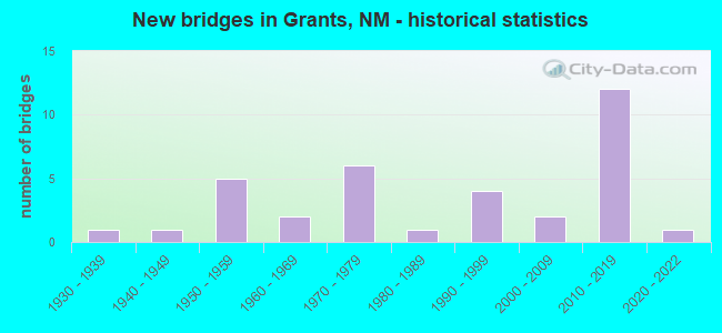
- New bridges - historical statistics
- 11930-1939
- 11940-1949
- 51950-1959
- 21960-1969
- 61970-1979
- 11980-1989
- 41990-1999
- 22000-2009
- 122010-2019
- 12020-2022
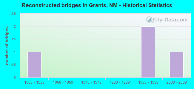
- Reconstructed bridges - Historical Statistics
- 11950-1959
- 01960-1969
- 01970-1979
- 01980-1989
- 21990-1999
- 12000-2009
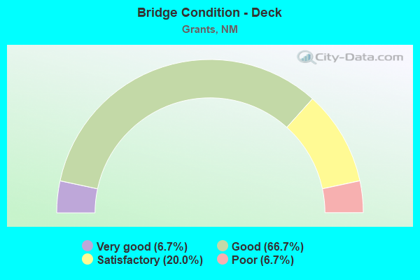
- Bridge Condition - Deck
- 6.7%Very good
- 66.7%Good
- 20.0%Satisfactory
- 6.7%Poor
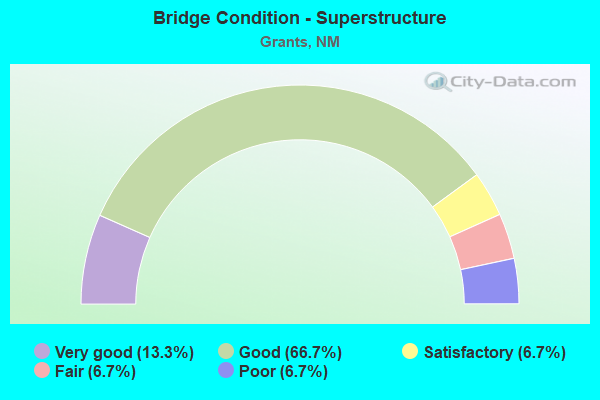
- Bridge Condition - Superstructure
- 13.3%Very good
- 66.7%Good
- 6.7%Satisfactory
- 6.7%Fair
- 6.7%Poor
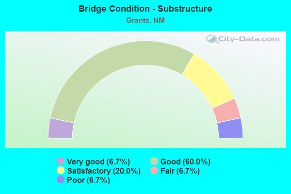
- Bridge Condition - Substructure
- 6.7%Very good
- 60.0%Good
- 20.0%Satisfactory
- 6.7%Fair
- 6.7%Poor
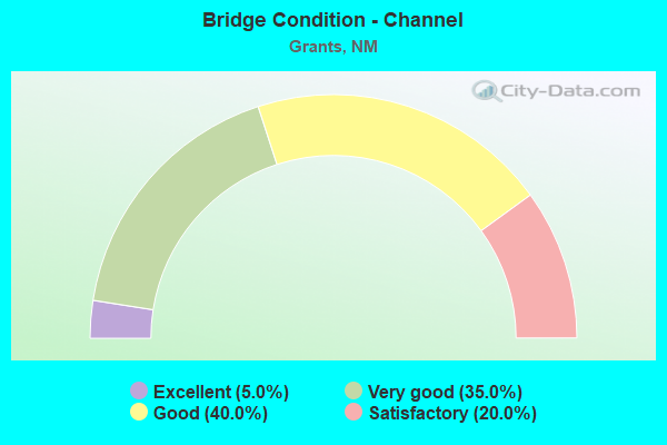
- Bridge Condition - Channel
- 5.0%Excellent
- 35.0%Very good
- 40.0%Good
- 20.0%Satisfactory
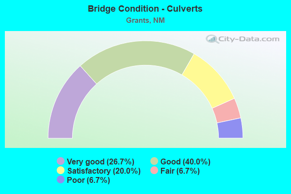
- Bridge Condition - Culverts
- 26.7%Very good
- 40.0%Good
- 20.0%Satisfactory
- 6.7%Fair
- 6.7%Poor
Find on map >> Show street view
Structure Number: 3104, Location: 1.24 MI E OF NM-122 (Lat: 35.130103, Lng: -107.809758), Route carried "on" structure: State highway 117, Year Built: 1940, Status: Open, Structure Length: 0.79m (2.59ft), Average Daily Traffic: 1,629 (year 2020), Truck Traffic: 21%, Average Future Daily Traffic: 1,400 (year 2040), Design Load: H 15, Features Intersected: UNNAMED WATERWAY
Minimum Vertical Clearance: 30+ m (98+ ft), Kilometerpoint: 97.848, Lanes on structure: 2, Owner: State Highway Agency, Approaching Roadway Width: 8.5m (27.9ft), Material/Design: Concrete continuous, Design/Construction: Culvert, Number Of Spans In Main Unit: 3, Length of Maximum Span: 2.4m (7.9ft)
Condition: Channel: Good, Culverts: Good, Operating Rating: 55.1 metric tons, Method Used To Determine Operating Rating: Load Factor (LF), Inventory Rating: 24.3 metric tons, Method Used To Determine Inventory Rating: Load Factor (LF), Structural Evaluation: Equal to present minimum criteria, Waterway Adequacy: Equal to present minimum criteria, Approach Roadway Alignment: Equal to present desirable criteria, Designated Inspection Frequency: Every 48 months, Inspection Date: July 2019
Find on map >> Show street view
Structure Number: 3106, Location: 1.3 MI E OF NM-605 (Lat: 35.168469, Lng: -107.889608), Route carried "on" structure: State highway 122, Year Built: 1939, Year Reconstructed: 1955, Status: Open, Structure Length: 0.70m (2.30ft), Average Daily Traffic: 9,412 (year 2020), Truck Traffic: 15%, Average Future Daily Traffic: 8,767 (year 2040), Design Load: HS 15, Features Intersected: UNNAMED WATERWAY
Minimum Vertical Clearance: 30+ m (98+ ft), Kilometerpoint: 53.610, Lanes on structure: 4, Base Highway Network: Yes, Owner: State Highway Agency, Approaching Roadway Width: 30.5m (100.1ft), Skew: 20 degrees, Material/Design: Concrete continuous, Design/Construction: Culvert, Number Of Spans In Main Unit: 3, Length of Maximum Span: 2.1m (6.9ft)
Condition: Channel: Satisfactory, Culverts: Fair, Operating Rating: 35.6 metric tons, Method Used To Determine Operating Rating: Load Factor (LF), Inventory Rating: 24.3 metric tons, Method Used To Determine Inventory Rating: Load Factor (LF), Structural Evaluation: Somewhat better than minimum adequacy, Waterway Adequacy: Equal to present minimum criteria, Approach Roadway Alignment: Equal to present desirable criteria, Length Of Structure Improvement: 0.70m (2.30ft), Designated Inspection Frequency: Every 48 months, Inspection Date: July 2020, Bridge Improvement Cost: $153,000, Roadway Improvement Cost: $15,000, Total Project Cost: $229,000 ( Estimate for 2020)
Find on map >> Show street view
Structure Number: 5494, Location: 1.0 MI E OF NM-53/GRANTS (Lat: 35.152722, Lng: -107.854444), Route carried "on" structure: State highway 122, Year Built: 1955, Status: Open, Structure Length: 2.74m (8.99ft), Average Daily Traffic: 12,007 (year 2020), Truck Traffic: 13%, Average Future Daily Traffic: 13,506 (year 2040), Design Load: HS 20, Features Intersected: RIO SAN JOSE
Minimum Vertical Clearance: 30+ m (98+ ft), Kilometerpoint: 57.285, Lanes on structure: 4, Base Highway Network: Yes, Owner: State Highway Agency, Approaching Roadway Width: 20.7m (67.9ft), Skew: 32 degrees, Material/Design: Concrete continuous, Design/Construction: Slab, Number Of Spans In Main Unit: 3, Length of Maximum Span: 8.8m (28.9ft), Curb or Sidewalk Widths: Left: 2.6m (8.5ft), Right: 2.6m (8.5ft), Curb-To-Curb Width: 25.0m (82.0ft), Out-to-Out Width: 30.5m (100.1ft)
Condition: Deck: Satisfactory, Superstructure: Satisfactory, Substructure: Satisfactory, Channel: Satisfactory, Operating Rating: 47.5 metric tons, Method Used To Determine Operating Rating: Load Factor (LF), Inventory Rating: 28.4 metric tons, Method Used To Determine Inventory Rating: Load Factor (LF), Structural Evaluation: Equal to present minimum criteria, Deck Geometry: Superior to present desirable criteria, Waterway Adequacy: Equal to present desirable criteria, Approach Roadway Alignment: Equal to present desirable criteria, Designated Inspection Frequency: Every 24 months, Inspection Date: March 2022, Deck Structure Type: Concrete Cast-file-Place, Wearing Surface/Protective System: Wearing Surface: Bituminous
Find on map >> Show street view
Structure Number: 5981, Location: 2.9 MI E OF NM-53/GRANTS (Lat: 35.137281, Lng: -107.827900), Route carried "on" structure: State highway 122, Year Built: 1959, Year Reconstructed: 2004, Status: Open, Structure Length: 5.79m (19.00ft), Average Daily Traffic: 7,199 (year 2020), Truck Traffic: 11%, Average Future Daily Traffic: 1,619 (year 2040), Design Load: HS 20, Features Intersected: BNSF RAILROAD
Minimum Vertical Clearance: 30+ m (98+ ft), Kilometerpoint: 60.443, Lanes on structure: 2, Base Highway Network: Yes, Owner: State Highway Agency, Approaching Roadway Width: 10.7m (35.1ft), Skew: 14 degrees, Material/Design: Steel continuous, Design/Construction: Stringer/Multi-beam, Number Of Spans In Main Unit: 3, Length of Maximum Span: 22.3m (73.2ft), Curb-To-Curb Width: 8.9m (29.2ft), Out-to-Out Width: 9.7m (31.8ft)
Condition: Deck: Good, Superstructure: Good, Substructure: Good, Operating Rating: 63.2 metric tons, Method Used To Determine Operating Rating: Load Factor (LF), Inventory Rating: 32.4 metric tons, Method Used To Determine Inventory Rating: Load Factor (LF), Structural Evaluation: Better than present minimum criteria, Deck Geometry: High priority of corrective action, Underclear: Equal to present minimum criteria, Approach Roadway Alignment: Equal to present desirable criteria, Length Of Structure Improvement: 5.82m (19.09ft), Designated Inspection Frequency: Every 24 months, Inspection Date: January 2021, Bridge Improvement Cost: $510,000, Roadway Improvement Cost: $66,000, Total Project Cost: $780,000 ( Estimate for 2020), Deck Structure Type: Concrete Cast-file-Place, Wearing Surface/Protective System: Deck Protection: Epoxy Coated Reinforcing
Find on map >> Show street view
Structure Number: 5982, Location: 2.9 MI E OF NM-53/GRANTS (Lat: 35.137372, Lng: -107.828111), Route carried "on" structure: State highway 122, Year Built: 1959, Year Reconstructed: 2004, Status: Open, Structure Length: 5.79m (19.00ft), Average Daily Traffic: 7,199 (year 2020), Truck Traffic: 11%, Average Future Daily Traffic: 1,619 (year 2040), Design Load: HS 20, Features Intersected: BNSF RAILROAD
Minimum Vertical Clearance: 30+ m (98+ ft), Kilometerpoint: 60.427, Lanes on structure: 2, Base Highway Network: Yes, Owner: State Highway Agency, Approaching Roadway Width: 10.7m (35.1ft), Skew: 14 degrees, Material/Design: Steel continuous, Design/Construction: Stringer/Multi-beam, Number Of Spans In Main Unit: 3, Length of Maximum Span: 22.3m (73.2ft), Curb-To-Curb Width: 9.0m (29.5ft), Out-to-Out Width: 9.7m (31.8ft)
Condition: Deck: Good, Superstructure: Good, Substructure: Good, Operating Rating: 63.2 metric tons, Method Used To Determine Operating Rating: Load Factor (LF), Inventory Rating: 32.4 metric tons, Method Used To Determine Inventory Rating: Load Factor (LF), Structural Evaluation: Better than present minimum criteria, Deck Geometry: High priority of corrective action, Underclear: Equal to present minimum criteria, Approach Roadway Alignment: Equal to present desirable criteria, Length Of Structure Improvement: 5.82m (19.09ft), Designated Inspection Frequency: Every 24 months, Inspection Date: January 2021, Bridge Improvement Cost: $510,000, Roadway Improvement Cost: $66,000, Total Project Cost: $780,000 ( Estimate for 2020), Deck Structure Type: Concrete Cast-file-Place, Wearing Surface/Protective System: Deck Protection: Epoxy Coated Reinforcing
Find on map >> Show street view
Structure Number: 6086, Location: 0.1 MI E OF NM-400 (Lat: 35.510469, Lng: -108.539308), Route carried "on" structure: Interstate 40, Year Built: 1958, Status: Open, Structure Length: 1.80m (5.91ft), Average Daily Traffic: 19,188 (year 2020), Truck Traffic: 37%, Average Future Daily Traffic: 32,848 (year 2040), Design Load: HS 20, Features Intersected: UNNAMED WATERWAY
Minimum Vertical Clearance: 30+ m (98+ ft), Kilometerpoint: 54.267, Lanes on structure: 4, Base Highway Network: Yes, Owner: State Highway Agency, Approaching Roadway Width: 21.9m (71.9ft), Skew: 24 degrees, Material/Design: Concrete continuous, Design/Construction: Culvert, Number Of Spans In Main Unit: 4, Length of Maximum Span: 3.0m (9.8ft)
Condition: Channel: Good, Culverts: Satisfactory, Operating Rating: 37.3 metric tons, Method Used To Determine Operating Rating: Load Factor (LF), Inventory Rating: 32.4 metric tons, Method Used To Determine Inventory Rating: Load Factor (LF), Structural Evaluation: Equal to present minimum criteria, Waterway Adequacy: Equal to present desirable criteria, Approach Roadway Alignment: Equal to present desirable criteria, Designated Inspection Frequency: Every 48 months, Inspection Date: March 2018
Find on map >> Show street view
Structure Number: 6098, Location: 4.0 MI E OF JCT NM-53 (Lat: 35.116839, Lng: -107.818892), Route carried "on" structure: Interstate 40, Year Built: 1959, Status: Open, Structure Length: 1.62m (5.31ft), Average Daily Traffic: 20,347 (year 2020), Truck Traffic: 37%, Average Future Daily Traffic: 34,832 (year 2040), Design Load: HS 20, Features Intersected: UNNAMED WATERWAY
Minimum Vertical Clearance: 30+ m (98+ ft), Kilometerpoint: 138.259, Lanes on structure: 4, Base Highway Network: Yes, Owner: State Highway Agency, Approaching Roadway Width: 21.9m (71.9ft), Skew: 20 degrees, Material/Design: Concrete continuous, Design/Construction: Culvert, Number Of Spans In Main Unit: 4, Length of Maximum Span: 3.0m (9.8ft)
Condition: Channel: Good, Culverts: Satisfactory, Operating Rating: 40.5 metric tons, Method Used To Determine Operating Rating: Load Factor (LF), Inventory Rating: 32.4 metric tons, Method Used To Determine Inventory Rating: Load Factor (LF), Structural Evaluation: Equal to present minimum criteria, Waterway Adequacy: Equal to present desirable criteria, Approach Roadway Alignment: Equal to present desirable criteria, Designated Inspection Frequency: Every 48 months, Inspection Date: Febuary 2022
Find on map >> Show street view
Structure Number: 678, Location: 2.2 MI S JCT I-25/NM-107 (Lat: 33.619047, Lng: -107.141686), Route carried "on" structure: Interstate 25, Year Built: 1968, Status: Open, Structure Length: 5.30m (17.39ft), Average Daily Traffic: 5,355 (year 2020), Truck Traffic: 37%, Average Future Daily Traffic: 9,167 (year 2040), Design Load: HS 20, Features Intersected: SHEEP CREEK
Minimum Vertical Clearance: 30+ m (98+ ft), Kilometerpoint: 182.725, Lanes on structure: 2, Base Highway Network: Yes, Owner: State Highway Agency, Approaching Roadway Width: 11.9m (39.0ft), Material/Design: Prestressed concrete, Design/Construction: Stringer/Multi-beam, Number Of Spans In Main Unit: 3, Length of Maximum Span: 17.4m (57.1ft), Curb-To-Curb Width: 11.9m (39.0ft), Out-to-Out Width: 12.5m (41.0ft)
Condition: Deck: Satisfactory, Superstructure: Good, Substructure: Good, Channel: Good, Operating Rating: 63.2 metric tons, Method Used To Determine Operating Rating: Load Factor (LF), Inventory Rating: 35.6 metric tons, Method Used To Determine Inventory Rating: Load Factor (LF), Structural Evaluation: Better than present minimum criteria, Deck Geometry: Equal to present minimum criteria, Waterway Adequacy: Equal to present desirable criteria, Approach Roadway Alignment: Equal to present desirable criteria, Designated Inspection Frequency: Every 24 months, Inspection Date: August 2021, Deck Structure Type: Concrete Cast-file-Place
Find on map >> Show street view
Structure Number: 7143, Location: JCT NM-53/I-40 @ GRANTS (Lat: 35.153439, Lng: -107.873178), Route carried "on" structure: State highway 53, Year Built: 1974, Status: Open, Structure Length: 8.41m (27.59ft), Average Daily Traffic: 4,368 (year 2020), Truck Traffic: 17%, Average Future Daily Traffic: 4,665 (year 2040), Design Load: HS 20, Features Intersected: I-40 EBL/WBL mp 81.92
Minimum Vertical Clearance: 30+ m (98+ ft), Kilometerpoint: 137.763, Lanes on structure: 4, Lanes under structure: 5, Base Highway Network: Yes, Owner: State Highway Agency, Approaching Roadway Width: 22.9m (75.1ft), Skew: 21 degrees, Material/Design: Steel continuous, Design/Construction: Stringer/Multi-beam, Number Of Spans In Main Unit: 2, Length of Maximum Span: 41.1m (134.8ft), Curb-To-Curb Width: 21.9m (71.9ft), Out-to-Out Width: 21.9m (71.9ft)
Condition: Deck: Satisfactory, Superstructure: Fair, Substructure: Fair, Operating Rating: 64.8 metric tons, Method Used To Determine Operating Rating: Load Factor (LF), Inventory Rating: 32.4 metric tons, Method Used To Determine Inventory Rating: Load Factor (LF), Structural Evaluation: Somewhat better than minimum adequacy, Deck Geometry: Superior to present desirable criteria, Underclear: Somewhat better than minimum adequacy, Approach Roadway Alignment: Equal to present desirable criteria, Designated Inspection Frequency: Every 24 months, Inspection Date: March 2021, Deck Structure Type: Concrete Cast-file-Place, Wearing Surface/Protective System: Wearing Surface: Bituminous
Find on map >> Show street view
Structure Number: 7144, Location: 0.1 MI S OF NM-122 (Lat: 35.156314, Lng: -107.871986), Route carried "on" structure: State highway 53, Year Built: 1974, Status: Open, Structure Length: 18.87m (61.91ft), Average Daily Traffic: 4,727 (year 2020), Truck Traffic: 17%, Average Future Daily Traffic: 8,357 (year 2040), Design Load: HS 20, Features Intersected: RIO SAN JOSE/BNSF R/R
Minimum Vertical Clearance: 30+ m (98+ ft), Kilometerpoint: 138.059, Lanes on structure: 4, Owner: State Highway Agency, Approaching Roadway Width: 21.9m (71.9ft), Skew: 20 degrees, Material/Design: Prestressed concrete continuous, Design/Construction: Stringer/Multi-beam, Number Of Spans In Main Unit: 8, Length of Maximum Span: 25.9m (85.0ft), Curb-To-Curb Width: 21.9m (71.9ft), Out-to-Out Width: 22.9m (75.1ft)
Condition: Deck: Poor, Superstructure: Poor, Substructure: Poor, Channel: Good, Operating Rating: 64.8 metric tons, Method Used To Determine Operating Rating: Load Factor (LF), Inventory Rating: 32.4 metric tons, Method Used To Determine Inventory Rating: Load Factor (LF), Structural Evaluation: Meets minimum limits, Deck Geometry: Superior to present desirable criteria, Underclear: Better than present minimum criteria, Waterway Adequacy: Superior to present desirable criteria, Approach Roadway Alignment: Equal to present desirable criteria, Designated Inspection Frequency: Every 24 months, Inspection Date: March 2021, Deck Structure Type: Concrete Cast-file-Place, Wearing Surface/Protective System: Wearing Surface: Bituminous
Find on map >> Show street view
Structure Number: 7393, Location: Junction of I-40/NM 122 (Lat: 35.124103, Lng: -107.829669), Route carried "on" structure: State highway 122, Year Built: 1974, Status: Open, Structure Length: 5.94m (19.49ft), Average Daily Traffic: 2,553 (year 2020), Truck Traffic: 16%, Average Future Daily Traffic: 1,970 (year 2040), Design Load: HS 20, Features Intersected: I-40 EBL/WBL mp 85.13
Minimum Vertical Clearance: 30+ m (98+ ft), Kilometerpoint: 61.941, Lanes on structure: 4, Lanes under structure: 4, Base Highway Network: Yes, Owner: State Highway Agency, Approaching Roadway Width: 30.5m (100.1ft), Skew: 20 degrees, Material/Design: Prestressed concrete continuous, Design/Construction: Stringer/Multi-beam, Number Of Spans In Main Unit: 2, Length of Maximum Span: 29.0m (95.1ft), Curb-To-Curb Width: 24.1m (79.1ft), Out-to-Out Width: 25.3m (83.0ft)
Condition: Deck: Good, Superstructure: Good, Substructure: Satisfactory, Operating Rating: 64.8 metric tons, Method Used To Determine Operating Rating: Load Factor (LF), Inventory Rating: 32.3 metric tons, Method Used To Determine Inventory Rating: Load Factor (LF), Structural Evaluation: Equal to present minimum criteria, Deck Geometry: Superior to present desirable criteria, Underclear: Equal to present minimum criteria, Approach Roadway Alignment: Equal to present desirable criteria, Designated Inspection Frequency: Every 24 months, Inspection Date: November 2020, Deck Structure Type: Concrete Cast-file-Place, Wearing Surface/Protective System: Wearing Surface: Bituminous
Find on map >> Show street view
Structure Number: 8563, Location: 1.9 MI E OF NM-605 (Lat: 35.162475, Lng: -107.883256), Route carried "on" structure: State highway 122, Year Built: 1985, Year Reconstructed: 2012, Status: Open, Structure Length: 8.29m (27.20ft), Average Daily Traffic: 9,412 (year 2020), Truck Traffic: 15%, Average Future Daily Traffic: 8,767 (year 2040), Design Load: HS 20, Features Intersected: BNSF RAILROAD
Minimum Vertical Clearance: 30+ m (98+ ft), Kilometerpoint: 54.490, Lanes on structure: 4, Base Highway Network: Yes, Owner: State Highway Agency, Approaching Roadway Width: 20.4m (66.9ft), Skew: 25 degrees, Material/Design: Steel continuous, Design/Construction: Stringer/Multi-beam, Number Of Spans In Main Unit: 3, Length of Maximum Span: 32.8m (107.6ft), Curb-To-Curb Width: 26.2m (86.0ft), Out-to-Out Width: 27.1m (88.9ft)
Condition: Deck: Good, Superstructure: Good, Substructure: Satisfactory, Operating Rating: 66.8 metric tons, Method Used To Determine Operating Rating: Load Factor (LF), Inventory Rating: 40.0 metric tons, Method Used To Determine Inventory Rating: Load Factor (LF), Structural Evaluation: Equal to present minimum criteria, Deck Geometry: Superior to present desirable criteria, Underclear: Equal to present minimum criteria, Approach Roadway Alignment: Equal to present desirable criteria, Designated Inspection Frequency: Every 24 months, Inspection Date: May 2020, Deck Structure Type: Concrete Cast-file-Place, Wearing Surface/Protective System: Deck Protection: Epoxy Coated Reinforcing
Find on map >> Show street view
Structure Number: 9073, Location: 3.7 MI E. JCT NM122/NM117 (Lat: 35.106544, Lng: -107.780078), Route carried "on" structure: State highway 117, Year Built: 1999, Status: Open, Structure Length: 3.22m (10.56ft), Average Daily Traffic: 1,629 (year 2020), Truck Traffic: 21%, Average Future Daily Traffic: 1,400 (year 2040), Design Load: HS 20, Features Intersected: BNSF RAILROAD
Minimum Vertical Clearance: 7.21m (23.65ft), Kilometerpoint: 93.740, Lanes on structure: 2, Owner: State Highway Agency, Approaching Roadway Width: 11.6m (38.1ft), Skew: 4 degrees, Material/Design: Prestressed concrete, Design/Construction: Stringer/Multi-beam, Number Of Spans In Main Unit: 1, Length of Maximum Span: 30.5m (100.1ft), Curb-To-Curb Width: 12.3m (40.4ft), Out-to-Out Width: 13.1m (43.0ft)
Condition: Deck: Good, Superstructure: Very good, Substructure: Good, Operating Rating: 84.7 metric tons, Method Used To Determine Operating Rating: Load Factor (LF), Inventory Rating: 36.4 metric tons, Method Used To Determine Inventory Rating: Load Factor (LF), Structural Evaluation: Better than present minimum criteria, Deck Geometry: Better than present minimum criteria, Underclear: Better than present minimum criteria, Approach Roadway Alignment: Equal to present desirable criteria, Designated Inspection Frequency: Every 24 months, Inspection Date: May 2021, Deck Structure Type: Concrete Cast-file-Place, Wearing Surface/Protective System: Deck Protection: Epoxy Coated Reinforcing
Find on map >> Show street view
Structure Number: 9074, Location: 0.13 MI E OF JCT NM122 (Lat: 35.138886, Lng: -107.826803), Route carried "on" structure: State highway 117, Year Built: 1998, Status: Open, Structure Length: 1.49m (4.89ft), Average Daily Traffic: 1,629 (year 2020), Truck Traffic: 21%, Average Future Daily Traffic: 1,400 (year 2040), Features Intersected: RIO SAN JOSE
Minimum Vertical Clearance: 30+ m (98+ ft), Kilometerpoint: 99.433, Lanes on structure: 2, Owner: State Highway Agency, Approaching Roadway Width: 12.2m (40.0ft), Material/Design: Concrete continuous, Design/Construction: Culvert, Number Of Spans In Main Unit: 4, Length of Maximum Span: 3.0m (9.8ft)
Condition: Channel: Good, Culverts: Very good, Operating Rating: 38.9 metric tons, Method Used To Determine Operating Rating: Load Factor (LF), Inventory Rating: 32.4 metric tons, Method Used To Determine Inventory Rating: Load Factor (LF), Structural Evaluation: Equal to present desirable criteria, Waterway Adequacy: Equal to present desirable criteria, Approach Roadway Alignment: Equal to present desirable criteria, Designated Inspection Frequency: Every 48 months, Inspection Date: November 2018
Find on map >> Show street view
Structure Number: 9261, Location: I-40 EXIT 104 SEAMA INTCH (Lat: 35.056033, Lng: -107.521764), Route carried "on" structure: State highway 4032, Year Built: 2008, Status: Open, Structure Length: 7.19m (23.59ft), Average Daily Traffic: 528 (year 2020), Truck Traffic: 12%, Average Future Daily Traffic: 454 (year 2040), Design Load: HS 20, Features Intersected: I-40 EBL & WBL
Minimum Vertical Clearance: 30+ m (98+ ft), Kilometerpoint: 0.016, Lanes on structure: 2, Lanes under structure: 4, Owner: State Highway Agency, Approaching Roadway Width: 11.0m (36.1ft), Material/Design: Prestressed concrete continuous, Design/Construction: Stringer/Multi-beam, Number Of Spans In Main Unit: 2, Length of Maximum Span: 36.0m (118.1ft), Curb-To-Curb Width: 11.0m (36.1ft), Out-to-Out Width: 11.9m (39.0ft)
Condition: Deck: Good, Superstructure: Good, Substructure: Good, Operating Rating: 81.6 metric tons, Method Used To Determine Operating Rating: Load Factor (LF), Inventory Rating: 49.0 metric tons, Method Used To Determine Inventory Rating: Load Factor (LF), Structural Evaluation: Better than present minimum criteria, Deck Geometry: Better than present minimum criteria, Underclear: Better than present minimum criteria, Approach Roadway Alignment: Equal to present minimum criteria, Designated Inspection Frequency: Every 24 months, Inspection Date: September 2021, Deck Structure Type: Concrete Cast-file-Place, Wearing Surface/Protective System: Deck Protection: Epoxy Coated Reinforcing
Find on map >> Show street view
Structure Number: 9489, Location: 0.24 Mi N Of Jct Nm-122 (Lat: 35.147156, Lng: -107.835822), Route carried "on" structure: City street 5953, Year Built: 2011, Status: Open, Structure Length: 1.62m (5.31ft), Average Daily Traffic: 4,038 (year 2020), Truck Traffic: 6%, Average Future Daily Traffic: 6,579 (year 2040), Design Load: HS 20, Features Intersected: Rio San Jose, Facility Carried by Structure: Nimitz Street
Minimum Vertical Clearance: 30+ m (98+ ft), Kilometerpoint: 0.322, Lanes on structure: 2, Owner: City or Municipal Highway Agency, Approaching Roadway Width: 9.1m (29.9ft), Skew: 1 degrees, Material/Design: Prestressed concrete, Design/Construction: Box Beam or Girders - Multiple, Number Of Spans In Main Unit: 1, Length of Maximum Span: 15.8m (51.8ft), Curb or Sidewalk Widths: Left: 1.2m (3.9ft), Right: 1.2m (3.9ft), Curb-To-Curb Width: 9.1m (29.9ft), Out-to-Out Width: 11.9m (39.0ft)
Condition: Deck: Good, Superstructure: Good, Substructure: Good, Channel: Satisfactory, Operating Rating: 55.4 metric tons, Method Used To Determine Operating Rating: Load Factor (LF), Inventory Rating: 33.1 metric tons, Method Used To Determine Inventory Rating: Load Factor (LF), Structural Evaluation: Better than present minimum criteria, Deck Geometry: Meets minimum limits, Waterway Adequacy: Equal to present minimum criteria, Approach Roadway Alignment: Equal to present desirable criteria, Length Of Structure Improvement: 6.10m (20.01ft), Designated Inspection Frequency: Every 24 months, Inspection Date: September 2020, Bridge Improvement Cost: $250,000, Roadway Improvement Cost: $50,000, Total Project Cost: $500,000 ( Estimate for 2050), Deck Structure Type: Concrete Cast-file-Place, Wearing Surface/Protective System: Deck Protection: Epoxy Coated Reinforcing
Find on map >> Show street view
Structure Number: 9616, Location: I-40, Exit 36 (Lat: 35.492369, Lng: -108.489953), Route carried "on" structure: Ramp State highway 118, Year Built: 2014, Status: Open, Structure Length: 9.33m (30.61ft), Average Daily Traffic: 236 (year 2018), Truck Traffic: 10%, Average Future Daily Traffic: 351 (year 2038), Design Load: HL 93, Features Intersected: I-40 EBLS/WBLS mp 36.8
Minimum Vertical Clearance: 30+ m (98+ ft), Kilometerpoint: 59.125, Lanes on structure: 2, Lanes under structure: 4, Owner: State Highway Agency, Approaching Roadway Width: 11.3m (37.1ft), Material/Design: Prestressed concrete continuous, Design/Construction: Stringer/Multi-beam, Number Of Spans In Main Unit: 4, Length of Maximum Span: 29.3m (96.1ft), Curb-To-Curb Width: 11.3m (37.1ft), Out-to-Out Width: 11.3m (37.1ft)
Condition: Deck: Good, Superstructure: Good, Substructure: Good, Structural Evaluation: Better than present minimum criteria, Deck Geometry: Superior to present desirable criteria, Underclear: High priority of corrective action, Approach Roadway Alignment: Equal to present minimum criteria, Designated Inspection Frequency: Every 24 months, Inspection Date: December 2021, Deck Structure Type: Concrete Cast-file-Place, Wearing Surface/Protective System: Wearing Surface: Monolithic Concrete, Membrane: Epoxy, Deck Protection: Epoxy Coated Reinforcing
Find on map >> Show street view
Structure Number: 9654, Location: 0.3 M North of NM 122 (Lat: 35.153989, Lng: -107.846586), Route carried "on" structure: State highway 547, Year Built: 2013, Status: Open, Structure Length: 1.17m (3.84ft), Average Daily Traffic: 6,388 (year 2020), Truck Traffic: 7%, Average Future Daily Traffic: 6,052 (year 2040), Design Load: HL 93, Features Intersected: Rio San Jose
Minimum Vertical Clearance: 30+ m (98+ ft), Kilometerpoint: 0.483, Lanes on structure: 3, Base Highway Network: Yes, Owner: City or Municipal Highway Agency, Approaching Roadway Width: 13.9m (45.6ft), Material/Design: Concrete continuous, Design/Construction: Culvert, Number Of Spans In Main Unit: 3, Length of Maximum Span: 3.7m (12.1ft), Curb-To-Curb Width: 13.9m (45.6ft), Out-to-Out Width: 21.1m (69.2ft)
Condition: Channel: Very good, Culverts: Good, Operating Rating: 64.4 metric tons, Method Used To Determine Operating Rating: Load Factor (LF), Inventory Rating: 39.0 metric tons, Method Used To Determine Inventory Rating: Load Factor (LF), Structural Evaluation: Better than present minimum criteria, Deck Geometry: Somewhat better than minimum adequacy, Waterway Adequacy: Equal to present desirable criteria, Approach Roadway Alignment: Equal to present desirable criteria, Designated Inspection Frequency: Every 48 months, Inspection Date: May 2021
Find on map >> Show street view
Structure Number: 9659, Location: TOP OF WORLD, EXIT 47 (Lat: 35.423747, Lng: -108.312394), Route carried "on" structure: State highway 122, Year Built: 2017, Status: Open, Structure Length: 5.49m (18.01ft), Average Daily Traffic: 270 (year 2020), Average Future Daily Traffic: 445 (year 2040), Design Load: HS 20, Features Intersected: I-40 EBLS/WBLS @ MP 47.9
Minimum Vertical Clearance: 30+ m (98+ ft), Kilometerpoint: 0.161, Lanes on structure: 2, Lanes under structure: 4, Owner: State Highway Agency, Approaching Roadway Width: 10.7m (35.1ft), Material/Design: Prestressed concrete continuous, Design/Construction: Stringer/Multi-beam, Number Of Spans In Main Unit: 2, Length of Maximum Span: 27.4m (89.9ft), Curb-To-Curb Width: 7.0m (23.0ft), Out-to-Out Width: 11.9m (39.0ft)
Condition: Deck: Good, Superstructure: Good, Substructure: Good, Operating Rating: 89.6 metric tons, Method Used To Determine Operating Rating: Load Factor (LF), Inventory Rating: 42.3 metric tons, Method Used To Determine Inventory Rating: Load Factor (LF), Structural Evaluation: Better than present minimum criteria, Deck Geometry: Meets minimum limits, Underclear: Meets minimum limits, Approach Roadway Alignment: Equal to present desirable criteria, Designated Inspection Frequency: Every 24 months, Inspection Date: July 2021, Deck Structure Type: Concrete Cast-file-Place, Wearing Surface/Protective System: Wearing Surface: Low Slump Concrete, Membrane: Epoxy, Deck Protection: Epoxy Coated Reinforcing
Find on map >> Show street view
Structure Number: 9686, Location: 3.7 M E IF NM 117 (Lat: 35.064667, Lng: -107.712000), Route carried "on" structure: Interstate 40, Year Built: 2016, Status: Open, Structure Length: 1.22m (4.00ft), Average Daily Traffic: 23,631 (year 2020), Truck Traffic: 47%, Average Future Daily Traffic: 38,511 (year 2040), Design Load: HS 20, Features Intersected: Rio San Jose
Minimum Vertical Clearance: 30+ m (98+ ft), Kilometerpoint: 149.830, Lanes on structure: 2, Base Highway Network: Yes, Owner: State Highway Agency, Approaching Roadway Width: 7.6m (24.9ft), Material/Design: Concrete continuous, Design/Construction: Culvert, Number Of Spans In Main Unit: 3, Length of Maximum Span: 3.7m (12.1ft), Curb-To-Curb Width: 7.6m (24.9ft), Out-to-Out Width: 18.0m (59.1ft)
Condition: Channel: Very good, Culverts: Good, Operating Rating: 63.7 metric tons, Method Used To Determine Operating Rating: Load Factor (LF), Inventory Rating: 38.3 metric tons, Method Used To Determine Inventory Rating: Load Factor (LF), Structural Evaluation: Better than present minimum criteria, Deck Geometry: High priority of replacement, Waterway Adequacy: Superior to present desirable criteria, Approach Roadway Alignment: Equal to present desirable criteria, Designated Inspection Frequency: Every 48 months, Inspection Date: June 2021, Deck Structure Type: Concrete Cast-file-Place, Wearing Surface/Protective System: Wearing Surface: Other, Deck Protection: Epoxy Coated Reinforcing
Find on map >> Show street view
Structure Number: 9687, Location: 3.7 M E IF NM 117 (Lat: 35.064289, Lng: -107.712022), Route carried "on" structure: Interstate 40, Year Built: 2016, Status: Open, Structure Length: 1.22m (4.00ft), Average Daily Traffic: 23,631 (year 2020), Truck Traffic: 47%, Average Future Daily Traffic: 38,511 (year 2040), Design Load: HS 20, Features Intersected: Rio San Jose
Minimum Vertical Clearance: 30+ m (98+ ft), Kilometerpoint: 149.830, Lanes on structure: 2, Base Highway Network: Yes, Owner: State Highway Agency, Approaching Roadway Width: 7.6m (24.9ft), Material/Design: Concrete continuous, Design/Construction: Culvert, Number Of Spans In Main Unit: 3, Length of Maximum Span: 3.7m (12.1ft), Curb-To-Curb Width: 7.6m (24.9ft), Out-to-Out Width: 18.0m (59.1ft)
Condition: Channel: Very good, Culverts: Good, Operating Rating: 63.7 metric tons, Method Used To Determine Operating Rating: Load Factor (LF), Inventory Rating: 38.3 metric tons, Method Used To Determine Inventory Rating: Load Factor (LF), Structural Evaluation: Better than present minimum criteria, Deck Geometry: High priority of replacement, Waterway Adequacy: Superior to present desirable criteria, Approach Roadway Alignment: Equal to present desirable criteria, Designated Inspection Frequency: Every 48 months, Inspection Date: August 2021, Deck Structure Type: Concrete Cast-file-Place, Wearing Surface/Protective System: Wearing Surface: Low Slump Concrete, Membrane: Built-up, Deck Protection: Epoxy Coated Reinforcing
Find on map >> Show street view
Structure Number: 97, Location: McCartys I/C I-40 MP 96.5 (Lat: 35.074594, Lng: -107.655758), Route carried "on" structure: State highway 124, Year Built: 2018, Status: Open, Structure Length: 5.12m (16.80ft), Average Daily Traffic: 314 (year 2020), Truck Traffic: 20%, Average Future Daily Traffic: 269 (year 2040), Design Load: HS 20, Features Intersected: I-40 EBL/WBL
Minimum Vertical Clearance: 30+ m (98+ ft), Kilometerpoint: 11.845, Lanes on structure: 2, Lanes under structure: 4, Owner: State Highway Agency, Approaching Roadway Width: 11.3m (37.1ft), Skew: 9 degrees, Material/Design: Prestressed concrete continuous, Design/Construction: Stringer/Multi-beam, Number Of Spans In Main Unit: 2, Length of Maximum Span: 25.8m (84.6ft), Curb-To-Curb Width: 6.7m (22.0ft), Out-to-Out Width: 11.6m (38.1ft)
Condition: Deck: Very good, Superstructure: Very good, Substructure: Very good, Operating Rating: 93.7 metric tons, Method Used To Determine Operating Rating: Load Factor (LF), Inventory Rating: 47.8 metric tons, Method Used To Determine Inventory Rating: Load Factor (LF), Structural Evaluation: Equal to present desirable criteria, Deck Geometry: Meets minimum limits, Underclear: Equal to present minimum criteria, Approach Roadway Alignment: Equal to present minimum criteria, Designated Inspection Frequency: Every 24 months, Inspection Date: July 2020, Deck Structure Type: Concrete Cast-file-Place, Wearing Surface/Protective System: Deck Protection: Epoxy Coated Reinforcing
Find on map >> Show street view
Structure Number: 9729, Location: .01 M west fo Nm 547 (Lat: 35.167817, Lng: -107.832253), Route carried "on" structure: City street 6001, Year Built: 2016, Status: Open, Structure Length: 1.89m (6.20ft), Average Daily Traffic: 123 (year 2020), Average Future Daily Traffic: 179 (year 2040), Design Load: HL 93, Features Intersected: Rio Puerco, Facility Carried by Structure: College Drive
Minimum Vertical Clearance: 30+ m (98+ ft), Kilometerpoint: 0.161, Lanes on structure: 2, Base Highway Network: Yes, Owner: City or Municipal Highway Agency, Approaching Roadway Width: 7.3m (24.0ft), Material/Design: Steel, Design/Construction: Stringer/Multi-beam, Number Of Spans In Main Unit: 1, Length of Maximum Span: 18.9m (62.0ft), Curb or Sidewalk Widths: Left: 1.4m (4.6ft), Right: 1.4m (4.6ft), Curb-To-Curb Width: 7.3m (24.0ft), Out-to-Out Width: 11.0m (36.1ft)
Condition: Deck: Good, Superstructure: Good, Substructure: Good, Channel: Very good, Operating Rating: 53.9 metric tons, Method Used To Determine Operating Rating: Load Factor (LF), Inventory Rating: 32.7 metric tons, Method Used To Determine Inventory Rating: Load Factor (LF), Structural Evaluation: Better than present minimum criteria, Deck Geometry: Somewhat better than minimum adequacy, Waterway Adequacy: Somewhat better than minimum adequacy, Approach Roadway Alignment: Equal to present desirable criteria, Designated Inspection Frequency: Every 24 months, Inspection Date: July 2020, Deck Structure Type: Concrete Cast-file-Place, Wearing Surface/Protective System: Wearing Surface: Epoxy Overlay, Membrane: Epoxy, Deck Protection: Epoxy Coated Reinforcing
Find on map >> Show street view
Structure Number: 9791, Location: 500' S of Wash. ST. (Lat: 35.155358, Lng: -107.847092), Route carried "on" structure: City street 6001, Year Built: 2017, Status: Open, Structure Length: 1.28m (4.20ft), Average Daily Traffic: 123 (year 2020), Average Future Daily Traffic: 179 (year 2040), Design Load: HS 20, Features Intersected: Rio San Jose, Facility Carried by Structure: LOC-174097
Minimum Vertical Clearance: 30+ m (98+ ft), Kilometerpoint: 0.016, Lanes on structure: 2, Base Highway Network: Yes, Owner: City or Municipal Highway Agency, Approaching Roadway Width: 10.1m (33.1ft), Skew: 3 degrees, Material/Design: Concrete continuous, Design/Construction: Culvert, Number Of Spans In Main Unit: 3, Length of Maximum Span: 3.7m (12.1ft), Curb-To-Curb Width: 10.1m (33.1ft), Out-to-Out Width: 21.3m (69.9ft)
Condition: Channel: Very good, Culverts: Good, Operating Rating: 65.0 metric tons, Method Used To Determine Operating Rating: Load Factor (LF), Inventory Rating: 39.1 metric tons, Method Used To Determine Inventory Rating: Load Factor (LF), Structural Evaluation: Better than present minimum criteria, Deck Geometry: Better than present minimum criteria, Waterway Adequacy: Equal to present desirable criteria, Approach Roadway Alignment: Equal to present desirable criteria, Designated Inspection Frequency: Every 48 months, Inspection Date: July 2021, Deck Structure Type: Concrete Cast-file-Place, Wearing Surface/Protective System: Wearing Surface: Low Slump Concrete, Membrane: Built-up, Deck Protection: Epoxy Coated Reinforcing
Find on map >> Show street view
Structure Number: 9802, Location: 0.01 M N of Santa Fe Ave (Lat: 35.142000, Lng: -107.830500), Route carried "on" structure: City street 6001, Year Built: 2018, Status: Open, Structure Length: 1.62m (5.31ft), Average Daily Traffic: 992 (year 2020), Truck Traffic: 7%, Average Future Daily Traffic: 1,654 (year 2040), Design Load: HS 20, Features Intersected: Rio San Jose, Facility Carried by Structure: George Hanosh Blvd
Minimum Vertical Clearance: 30+ m (98+ ft), Kilometerpoint: 0.016, Lanes on structure: 2, Owner: County Highway Agency, Maintenance Responsibility: City or Municipal Highway Agency, Approaching Roadway Width: 7.5m (24.6ft), Skew: 1 degrees, Material/Design: Prestressed concrete, Design/Construction: Culvert, Number Of Spans In Main Unit: 1, Length of Maximum Span: 3.7m (12.1ft), Curb or Sidewalk Widths: Left: 1.6m (5.2ft), Right: 1.6m (5.2ft), Curb-To-Curb Width: 6.6m (21.7ft), Out-to-Out Width: 11.0m (36.1ft)
Condition: Channel: Very good, Culverts: Very good, Operating Rating: 63.7 metric tons, Method Used To Determine Operating Rating: Load Factor (LF), Inventory Rating: 38.2 metric tons, Method Used To Determine Inventory Rating: Load Factor (LF), Structural Evaluation: Equal to present desirable criteria, Deck Geometry: High priority of corrective action, Waterway Adequacy: Equal to present desirable criteria, Approach Roadway Alignment: Equal to present desirable criteria, Designated Inspection Frequency: Every 48 months, Inspection Date: Febuary 2022, Deck Structure Type: Concrete Cast-file-Place, Wearing Surface/Protective System: Deck Protection: Epoxy Coated Reinforcing
Find on map >> Show street view
Structure Number: 9989, Location: 0.032 Mi East of Bradley (Lat: 35.153903, Lng: -107.836264), Route carried "on" structure: City street 5946, Year Built: 2020, Status: Open, Structure Length: 1.83m (6.00ft), Average Daily Traffic: 123 (year 2020), Average Future Daily Traffic: 179 (year 2040), Design Load: HS 20, Features Intersected: GRANTS CANYON
Minimum Vertical Clearance: 30.48m (100.00ft), Kilometerpoint: 0.016, Lanes on structure: 2, Owner: City or Municipal Highway Agency, Approaching Roadway Width: 8.5m (27.9ft), Material/Design: Concrete continuous, Design/Construction: Culvert, Number Of Spans In Main Unit: 5, Length of Maximum Span: 3.0m (9.8ft), Curb or Sidewalk Widths: Left: 1.8m (5.9ft), Right: 1.8m (5.9ft), Curb-To-Curb Width: 9.4m (30.8ft), Out-to-Out Width: 30.5m (100.1ft)
Condition: Channel: Excellent, Culverts: Very good, Operating Rating: 82.6 metric tons, Method Used To Determine Operating Rating: Load Factor (LF), Inventory Rating: 50.1 metric tons, Method Used To Determine Inventory Rating: Load Factor (LF), Structural Evaluation: Equal to present desirable criteria, Deck Geometry: Equal to present minimum criteria, Waterway Adequacy: Equal to present desirable criteria, Approach Roadway Alignment: Equal to present desirable criteria, Designated Inspection Frequency: Every 48 months, Inspection Date: June 2021
Find on map >> Show street view
Structure Number: 10015, Location: 1.0 MI N OF NM-122/GRANTS (Lat: 35.161144, Lng: -107.837864), Route carried "on" structure: State highway 547, Year Built: 1960, Status: Open, Structure Length: 1.89m (6.20ft), Average Daily Traffic: 3,651 (year 2020), Truck Traffic: 7%, Average Future Daily Traffic: 4,090 (year 2040), Design Load: HS 20, Features Intersected: RIO SAN JOSE
Minimum Vertical Clearance: 30+ m (98+ ft), Kilometerpoint: 1.625, Lanes on structure: 2, Owner: City or Municipal Highway Agency, Approaching Roadway Width: 12.2m (40.0ft), Material/Design: Steel, Design/Construction: Culvert, Number Of Spans In Main Unit: 4, Length of Maximum Span: 3.0m (9.8ft)
Condition: Channel: Good, Culverts: Satisfactory, Operating Rating: 89.1 metric tons, Method Used To Determine Operating Rating: Load Factor (LF), Inventory Rating: 32.4 metric tons, Method Used To Determine Inventory Rating: Load Factor (LF), Structural Evaluation: Equal to present minimum criteria, Waterway Adequacy: Better than present minimum criteria, Approach Roadway Alignment: Equal to present desirable criteria, Designated Inspection Frequency: Every 48 months, Inspection Date: November 2019
Find on map >> Show street view
Structure Number: 10057, Location: 0.1 N OF NM-122 (Lat: 35.153614, Lng: -107.853403), Route carried "on" structure: City street 5952, Year Built: 1993, Status: Open, Structure Length: 1.22m (4.00ft), Average Daily Traffic: 583 (year 2020), Truck Traffic: 7%, Average Future Daily Traffic: 951 (year 2040), Design Load: HS 20, Features Intersected: RIO SAN JOSE
Minimum Vertical Clearance: 30+ m (98+ ft), Kilometerpoint: 0.161, Lanes on structure: 2, Owner: City or Municipal Highway Agency, Approaching Roadway Width: 12.2m (40.0ft), Skew: 4 degrees, Material/Design: Concrete continuous, Design/Construction: Culvert, Number Of Spans In Main Unit: 3, Length of Maximum Span: 3.0m (9.8ft), Curb or Sidewalk Widths: Left: 2.0m (6.6ft), Right: 2.0m (6.6ft)
Condition: Channel: Good, Culverts: Good, Operating Rating: 35.6 metric tons, Method Used To Determine Operating Rating: Load Factor (LF), Inventory Rating: 32.4 metric tons, Method Used To Determine Inventory Rating: Load Factor (LF), Structural Evaluation: Better than present minimum criteria, Waterway Adequacy: Better than present minimum criteria, Approach Roadway Alignment: Equal to present desirable criteria, Designated Inspection Frequency: Every 48 months, Inspection Date: October 2019
Find on map >> Show street view
Structure Number: 10067, Location: 0.17 MI S OF NM-122 (Lat: 35.154656, Lng: -107.870322), Route carried "on" structure: City street 5950, Year Built: 1993, Status: Open, Structure Length: 0.96m (3.15ft), Average Daily Traffic: 123 (year 2020), Average Future Daily Traffic: 179 (year 2040), Design Load: HS 20, Features Intersected: RIO SAN JOSE
Minimum Vertical Clearance: 30+ m (98+ ft), Kilometerpoint: 0.402, Lanes on structure: 2, Owner: City or Municipal Highway Agency, Approaching Roadway Width: 7.8m (25.6ft), Material/Design: Concrete continuous, Design/Construction: Culvert, Number Of Spans In Main Unit: 3, Length of Maximum Span: 3.0m (9.8ft)
Condition: Channel: Very good, Culverts: Very good, Operating Rating: 38.9 metric tons, Method Used To Determine Operating Rating: Load Factor (LF), Inventory Rating: 32.4 metric tons, Method Used To Determine Inventory Rating: Load Factor (LF), Structural Evaluation: Equal to present desirable criteria, Waterway Adequacy: Equal to present desirable criteria, Approach Roadway Alignment: Equal to present desirable criteria, Designated Inspection Frequency: Every 48 months, Inspection Date: October 2021
Find on map >> Show street view
Structure Number: 10093, Location: 500' N OF STEPHENS (Lat: 35.151497, Lng: -107.844236), Route carried "on" structure: City street 4956, Year Built: 1970, Status: Open, Structure Length: 0.94m (3.08ft), Average Daily Traffic: 976 (year 2020), Truck Traffic: 7%, Average Future Daily Traffic: 1,591 (year 2040), Design Load: HS 20, Features Intersected: RIO SAN JOSE
Minimum Vertical Clearance: 30+ m (98+ ft), Kilometerpoint: 0.016, Lanes on structure: 2, Owner: City or Municipal Highway Agency, Approaching Roadway Width: 12.2m (40.0ft), Material/Design: Steel, Design/Construction: Culvert, Number Of Spans In Main Unit: 3, Length of Maximum Span: 2.7m (8.9ft), Curb or Sidewalk Widths: Left: 2.3m (7.5ft), Right: 2.3m (7.5ft)
Condition: Channel: Satisfactory, Culverts: Poor, Operating Rating: 64.8 metric tons, Method Used To Determine Operating Rating: Load Factor (LF), Inventory Rating: 32.4 metric tons, Method Used To Determine Inventory Rating: Load Factor (LF), Structural Evaluation: Meets minimum limits, Waterway Adequacy: Equal to present desirable criteria, Approach Roadway Alignment: Equal to present desirable criteria, Designated Inspection Frequency: Every 24 months, Inspection Date: July 2021
Find on map >> Show street view
Structure Number: 7143, Location: JCT NM-53/I-40 @ GRANTS (Lat: 35.153439, Lng: -107.873178), Route carried "under" structure: Interstate 40, Year Built: 1974, Structure Length: 0. m, Average Daily Traffic: 22,736 (year 2020), Truck Traffic: 37%, Features Intersected: I-40 EBL/WBL mp 81.92, Facility Carried by Structure: NM-53
Minimum Vertical Clearance: 4.82m (15.81ft), Kilometerpoint: 131.815, Lanes on structure: 4, Lanes under structure: 5, Material/Design: Steel continuous, Design/Construction: Stringer/Multi-beam, Length of Maximum Span: 41.1m (134.8ft)
Find on map >> Show street view
Structure Number: 7393, Location: Junction of I-40/NM 122 (Lat: 35.124103, Lng: -107.829669), Route carried "under" structure: Interstate 40, Year Built: 1974, Structure Length: 0. m, Average Daily Traffic: 17,291 (year 2020), Truck Traffic: 37%, Features Intersected: I-40 EBL/WBL mp 85.13, Facility Carried by Structure: NM-122
Minimum Vertical Clearance: 5.11m (16.77ft), Kilometerpoint: 136.996, Lanes on structure: 4, Lanes under structure: 4, Material/Design: Prestressed concrete continuous, Design/Construction: Stringer/Multi-beam, Length of Maximum Span: 29.0m (95.1ft)
Find on map >> Show street view
Structure Number: 9261, Location: I-40 EXIT 104 SEAMA INTCH (Lat: 35.056033, Lng: -107.521764), Route carried "under" structure: Interstate 40, Year Built: 2008, Structure Length: 0. m, Average Daily Traffic: 20,497 (year 2020), Truck Traffic: 37%, Features Intersected: I-40 EBL & WBL
Minimum Vertical Clearance: 5.18m (16.99ft), Kilometerpoint: 168.659, Lanes on structure: 2, Lanes under structure: 4, Material/Design: Prestressed concrete continuous, Design/Construction: Stringer/Multi-beam, Length of Maximum Span: 36.0m (118.1ft)
Find on map >> Show street view
Structure Number: 9616, Location: I-40, Exit 36 (Lat: 35.492369, Lng: -108.489953), Route carried "under" structure: Interstate 40, Year Built: 2014, Structure Length: 0. m, Average Daily Traffic: 22,444 (year 2020), Truck Traffic: 37%, Features Intersected: I-40 EBLS/WBLS mp 36.8, Facility Carried by Structure: NM-118
Minimum Vertical Clearance: 5.18m (16.99ft), Kilometerpoint: 59.176, Lanes on structure: 2, Lanes under structure: 4, Material/Design: Prestressed concrete continuous, Design/Construction: Stringer/Multi-beam, Length of Maximum Span: 29.3m (96.1ft)
Find on map >> Show street view
Structure Number: 9659, Location: TOP OF WORLD, EXIT 47 (Lat: 35.423747, Lng: -108.312394), Route carried "under" structure: Interstate 40, Year Built: 2017, Structure Length: 0. m, Average Daily Traffic: 20,199 (year 2020), Truck Traffic: 37%, Features Intersected: I-40 EBLS/WBLS @ MP 47.9, Facility Carried by Structure: NM-122
Minimum Vertical Clearance: 5.18m (16.99ft), Kilometerpoint: 75.639, Lanes on structure: 2, Lanes under structure: 4, Material/Design: Prestressed concrete continuous, Design/Construction: Stringer/Multi-beam, Length of Maximum Span: 27.4m (89.9ft)