Bridge Statistics for Grantsville, Maryland (MD)
Condition, Traffic, Stress, Structural Evaluation, Project Costs
- National Bridge Inventory (NBI) Statistics
- 20Number of bridges
- 223ft / 67.9mTotal length
- $1,111,000Total costs
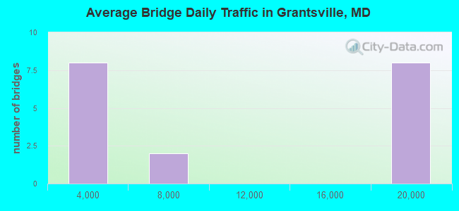
- 162,736Total average daily traffic
- 9,273Total average daily truck traffic
- National Bridge Inventory (NBI) Registered Bridges for Grantsville
- No street view available for this location
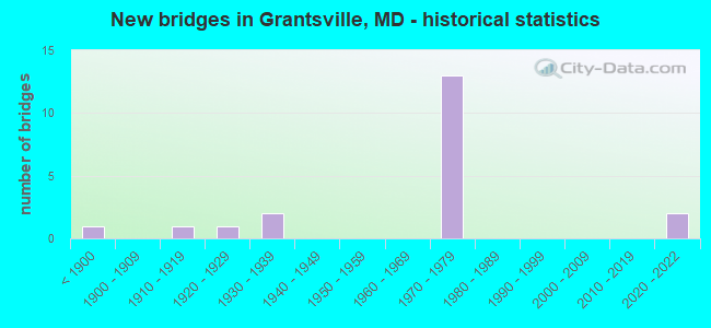
- New bridges - historical statistics
- 1Before 1900
- 11910-1919
- 11920-1929
- 21930-1939
- 131970-1979
- 22020-2022

- Bridge Condition - Deck
- 25.0%Very good
- 25.0%Good
- 25.0%Satisfactory
- 25.0%Fair
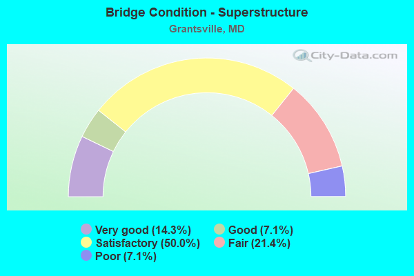
- Bridge Condition - Superstructure
- 14.3%Very good
- 7.1%Good
- 50.0%Satisfactory
- 21.4%Fair
- 7.1%Poor
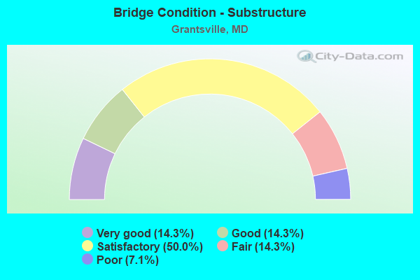
- Bridge Condition - Substructure
- 14.3%Very good
- 14.3%Good
- 50.0%Satisfactory
- 14.3%Fair
- 7.1%Poor
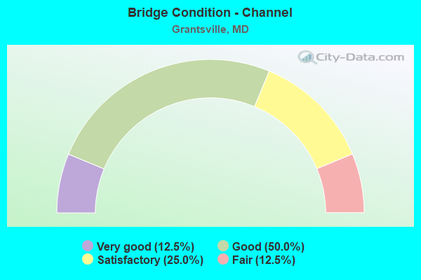
- Bridge Condition - Channel
- 12.5%Very good
- 50.0%Good
- 25.0%Satisfactory
- 12.5%Fair
Find on map >> Show street view
Structure Number: 10000011000601, Location: 0.62 MILE WEST OF MD 669 (Lat: 39.695733, Lng: -79.172156), Route carried "on" structure: Alternate US 40, Year Built: 1932, Status: Open, Structure Length: 0.94m (3.08ft), Average Daily Traffic: 1,783 (year 2009), Truck Traffic: 8%, Average Future Daily Traffic: 2,133 (year 2026), Features Intersected: BIG SHADE RUN
Minimum Vertical Clearance: 30+ m (98+ ft), Kilometerpoint: 7.530, Lanes on structure: 2, Owner: State Highway Agency, Approaching Roadway Width: 12.2m (40.0ft), Material/Design: Concrete, Design/Construction: Tee Beam, Number Of Spans In Main Unit: 1, Length of Maximum Span: 8.5m (27.9ft), Curb-To-Curb Width: 12.2m (40.0ft), Out-to-Out Width: 13.3m (43.6ft)
Condition: Deck: Fair, Superstructure: Fair, Substructure: Satisfactory, Channel: Good, Operating Rating: 51.7 metric tons, Method Used To Determine Operating Rating: Load Factor (LF), Inventory Rating: 31.3 metric tons, Method Used To Determine Inventory Rating: Load Factor (LF), Structural Evaluation: Somewhat better than minimum adequacy, Deck Geometry: Better than present minimum criteria, Waterway Adequacy: Equal to present desirable criteria, Approach Roadway Alignment: Equal to present minimum criteria, Length Of Structure Improvement: 0.94m (3.08ft), Designated Inspection Frequency: Every 24 months, Inspection Date: August 2020, Bridge Improvement Cost: $81,000, Roadway Improvement Cost: $8,000, Total Project Cost: $89,000, Deck Structure Type: Concrete Cast-file-Place, Wearing Surface/Protective System: Wearing Surface: Bituminous
Find on map >> Show street view
Structure Number: 10000011000701, Location: 0.82 MILE EAST OF MD 495 (Lat: 39.696028, Lng: -79.142078), Route carried "on" structure: Alternate US 40, Year Built: 1932, Status: Open, Structure Length: 4.18m (13.71ft), Average Daily Traffic: 3,841 (year 2014), Truck Traffic: 8%, Average Future Daily Traffic: 4,687 (year 2034), Design Load: H 20, Features Intersected: CASSELMAN RIVER
Minimum Vertical Clearance: 4.27m (14.01ft), Kilometerpoint: 10.314, Lanes on structure: 2, Owner: State Highway Agency, Approaching Roadway Width: 9.8m (32.2ft), Skew: 4 degrees, Material/Design: Steel, Design/Construction: Truss - Thru, Number Of Spans In Main Unit: 1, Length of Maximum Span: 40.5m (132.9ft), Curb-To-Curb Width: 12.2m (40.0ft), Out-to-Out Width: 12.7m (41.7ft)
Condition: Deck: Good, Superstructure: Fair, Substructure: Satisfactory, Channel: Good, Operating Rating: 72.1 metric tons, Method Used To Determine Operating Rating: Load Factor (LF), Inventory Rating: 43.1 metric tons, Method Used To Determine Inventory Rating: Load Factor (LF), Structural Evaluation: Somewhat better than minimum adequacy, Deck Geometry: Meets minimum limits, Waterway Adequacy: Superior to present desirable criteria, Approach Roadway Alignment: Equal to present desirable criteria, Length Of Structure Improvement: 4.18m (13.71ft), Designated Inspection Frequency: Every 24 months, Critical Feature Inspection Frequency: Every 24 months, Inspection Date: August 2021, Critical Feature Inspection Date: August 2021, Bridge Improvement Cost: $343,000, Roadway Improvement Cost: $34,000, Total Project Cost: $377,000, Deck Structure Type: Concrete Cast-file-Place, Wearing Surface/Protective System: Wearing Surface: Bituminous
Find on map >> Show street view
Structure Number: 10000011001901, Location: 0.19 M N OF NORTH PARK RD (Lat: 39.692778, Lng: -79.159447), Route carried "on" structure: State highway 495, Year Built: 1974, Status: Open, Structure Length: 6.86m (22.51ft), Average Daily Traffic: 2,581 (year 2009), Truck Traffic: 8%, Average Future Daily Traffic: 3,057 (year 2026), Design Load: HS 20, Features Intersected: IS 68/US 219
Minimum Vertical Clearance: 30+ m (98+ ft), Kilometerpoint: 36.556, Lanes on structure: 2, Lanes under structure: 6, Owner: State Highway Agency, Approaching Roadway Width: 17.1m (56.1ft), Skew: 2 degrees, Material/Design: Steel continuous, Design/Construction: Stringer/Multi-beam, Number Of Spans In Main Unit: 2, Length of Maximum Span: 33.5m (109.9ft), Curb-To-Curb Width: 17.1m (56.1ft), Out-to-Out Width: 18.0m (59.1ft)
Condition: Deck: Fair, Superstructure: Satisfactory, Substructure: Satisfactory, Operating Rating: 63.9 metric tons, Method Used To Determine Operating Rating: Load Factor (LF), Inventory Rating: 38.1 metric tons, Method Used To Determine Inventory Rating: Load Factor (LF), Structural Evaluation: Equal to present minimum criteria, Deck Geometry: Superior to present desirable criteria, Underclear: Somewhat better than minimum adequacy, Approach Roadway Alignment: Equal to present desirable criteria, Designated Inspection Frequency: Every 24 months, Inspection Date: June 2020, Deck Structure Type: Concrete Cast-file-Place, Wearing Surface/Protective System: Wearing Surface: Monolithic Concrete
Find on map >> Show street view
Structure Number: 10000011003201, Location: 0.11 MI S OF US 40AL (Lat: 39.694303, Lng: -79.119444), Route carried "on" structure: County highway 219, Year Built: 1974, Status: Open, Structure Length: 6.43m (21.10ft), Average Daily Traffic: 430 (year 1994), Truck Traffic: 5%, Average Future Daily Traffic: 531 (year 2012), Design Load: HS 20, Features Intersected: IS 68, US 219, Facility Carried by Structure: NEW GERMANY ROAD
Minimum Vertical Clearance: 30+ m (98+ ft), Kilometerpoint: 3.379, Lanes on structure: 2, Lanes under structure: 5, Owner: State Highway Agency, Approaching Roadway Width: 9.8m (32.2ft), Material/Design: Steel continuous, Design/Construction: Stringer/Multi-beam, Number Of Spans In Main Unit: 2, Length of Maximum Span: 34.1m (111.9ft), Curb-To-Curb Width: 9.8m (32.2ft), Out-to-Out Width: 10.7m (35.1ft)
Condition: Deck: Satisfactory, Superstructure: Satisfactory, Substructure: Satisfactory, Operating Rating: 49.9 metric tons, Method Used To Determine Operating Rating: Load Factor (LF), Inventory Rating: 29.9 metric tons, Method Used To Determine Inventory Rating: Load Factor (LF), Structural Evaluation: Equal to present minimum criteria, Deck Geometry: Equal to present minimum criteria, Underclear: Somewhat better than minimum adequacy, Approach Roadway Alignment: Equal to present desirable criteria, Designated Inspection Frequency: Every 24 months, Inspection Date: June 2020, Deck Structure Type: Concrete Cast-file-Place, Wearing Surface/Protective System: Wearing Surface: Monolithic Concrete
Find on map >> Show street view
Structure Number: 100000110050013, Location: 0.61 MILE WEST OF MD 495 (Lat: 39.693756, Lng: -79.170894), Route carried "on" structure: Interstate 68, Year Built: 1975, Status: Open, Structure Length: 3.87m (12.70ft), Average Daily Traffic: 17,530 (year 2009), Truck Traffic: 8%, Average Future Daily Traffic: 7,781 (year 2026), Design Load: HS 20, Features Intersected: SHADE HOLLOW ROAD
Minimum Vertical Clearance: 30+ m (98+ ft), Kilometerpoint: 29.894, Lanes on structure: 2, Lanes under structure: 2, Base Highway Network: Yes, Owner: State Highway Agency, Approaching Roadway Width: 11.6m (38.1ft), Material/Design: Steel continuous, Design/Construction: Stringer/Multi-beam, Number Of Spans In Main Unit: 3, Length of Maximum Span: 15.5m (50.9ft), Curb-To-Curb Width: 12.0m (39.4ft), Out-to-Out Width: 13.0m (42.7ft)
Condition: Deck: Good, Superstructure: Satisfactory, Substructure: Good, Operating Rating: 77.5 metric tons, Method Used To Determine Operating Rating: Load Factor (LF), Inventory Rating: 46.3 metric tons, Method Used To Determine Inventory Rating: Load Factor (LF), Structural Evaluation: Equal to present minimum criteria, Deck Geometry: Equal to present minimum criteria, Underclear: Superior to present desirable criteria, Approach Roadway Alignment: Equal to present desirable criteria, Designated Inspection Frequency: Every 24 months, Inspection Date: July 2020, Deck Structure Type: Concrete Cast-file-Place, Wearing Surface/Protective System: Wearing Surface: Monolithic Concrete, Deck Protection: Epoxy Coated Reinforcing
Find on map >> Show street view
Structure Number: 100000110050014, Location: 0.61 MILE WEST OF MD 495 (Lat: 39.693881, Lng: -79.170436), Route carried "on" structure: Interstate 68, Year Built: 1975, Status: Open, Structure Length: 3.87m (12.70ft), Average Daily Traffic: 17,530 (year 2009), Truck Traffic: 8%, Average Future Daily Traffic: 7,781 (year 2026), Design Load: HS 20, Features Intersected: SHADE HOLLOW ROAD
Minimum Vertical Clearance: 30+ m (98+ ft), Kilometerpoint: 29.894, Lanes on structure: 2, Lanes under structure: 2, Base Highway Network: Yes, Owner: State Highway Agency, Approaching Roadway Width: 11.6m (38.1ft), Material/Design: Steel continuous, Design/Construction: Stringer/Multi-beam, Number Of Spans In Main Unit: 3, Length of Maximum Span: 15.5m (50.9ft), Curb-To-Curb Width: 12.0m (39.4ft), Out-to-Out Width: 13.0m (42.7ft)
Condition: Deck: Satisfactory, Superstructure: Satisfactory, Substructure: Satisfactory, Operating Rating: 77.5 metric tons, Method Used To Determine Operating Rating: Load Factor (LF), Inventory Rating: 46.3 metric tons, Method Used To Determine Inventory Rating: Load Factor (LF), Structural Evaluation: Equal to present minimum criteria, Deck Geometry: Equal to present minimum criteria, Underclear: Equal to present minimum criteria, Approach Roadway Alignment: Equal to present desirable criteria, Designated Inspection Frequency: Every 24 months, Inspection Date: July 2020, Deck Structure Type: Concrete Cast-file-Place, Wearing Surface/Protective System: Wearing Surface: Monolithic Concrete, Deck Protection: Epoxy Coated Reinforcing
Find on map >> Show street view
Structure Number: 10000011005102, Location: 0.73 MILE WEST OF MD 495 (Lat: 39.693597, Lng: -79.169867), Route carried "on" structure: Interstate 68, Year Built: 1975, Status: Open, Structure Length: 0.62m (2.03ft), Average Daily Traffic: 16,541 (year 2013), Truck Traffic: 8%, Average Future Daily Traffic: 15,563 (year 2026), Design Load: HS 20, Features Intersected: BIG SHADE RUN
Minimum Vertical Clearance: 30+ m (98+ ft), Kilometerpoint: 29.503, Lanes on structure: 4, Base Highway Network: Yes, Owner: State Highway Agency, Approaching Roadway Width: 26.8m (87.9ft), Skew: 1 degrees, Material/Design: Concrete, Design/Construction: Culvert, Length of Maximum Span: 1.8m (5.9ft)
Condition: Channel: Satisfactory, Culverts: Satisfactory, Structural Evaluation: Equal to present minimum criteria, Waterway Adequacy: Equal to present desirable criteria, Approach Roadway Alignment: Equal to present desirable criteria, Designated Inspection Frequency: Every 24 months, Inspection Date: September 2020
Find on map >> Show street view
Structure Number: 100000110053013, Location: 1.08 MILE EAST OF MD 495 (Lat: 39.694728, Lng: -79.140650), Route carried "on" structure: Interstate 68, Year Built: 1975, Status: Open, Structure Length: 9.94m (32.61ft), Average Daily Traffic: 17,770 (year 2009), Truck Traffic: 8%, Average Future Daily Traffic: 9,833 (year 2026), Design Load: HS 20, Features Intersected: CASSELMAN RIVER
Minimum Vertical Clearance: 30+ m (98+ ft), Kilometerpoint: 32.576, Lanes on structure: 2, Base Highway Network: Yes, Owner: State Highway Agency, Approaching Roadway Width: 11.6m (38.1ft), Skew: 4 degrees, Material/Design: Steel continuous, Design/Construction: Stringer/Multi-beam, Number Of Spans In Main Unit: 3, Length of Maximum Span: 39.6m (129.9ft), Curb-To-Curb Width: 12.0m (39.4ft), Out-to-Out Width: 13.0m (42.7ft)
Condition: Deck: Satisfactory, Superstructure: Satisfactory, Substructure: Good, Channel: Good, Operating Rating: 83.0 metric tons, Method Used To Determine Operating Rating: Load Factor (LF), Inventory Rating: 49.9 metric tons, Method Used To Determine Inventory Rating: Load Factor (LF), Structural Evaluation: Equal to present minimum criteria, Deck Geometry: Equal to present minimum criteria, Waterway Adequacy: Meets minimum limits, Approach Roadway Alignment: Equal to present desirable criteria, Designated Inspection Frequency: Every 24 months, Inspection Date: October 2020, Deck Structure Type: Concrete Cast-file-Place, Wearing Surface/Protective System: Wearing Surface: Monolithic Concrete
Find on map >> Show street view
Structure Number: 100000110053014, Location: 1.08 MILE EAST OF MD 495 (Lat: 39.695169, Lng: -79.139903), Route carried "on" structure: Interstate 68, Year Built: 1975, Status: Open, Structure Length: 9.94m (32.61ft), Average Daily Traffic: 17,770 (year 2009), Truck Traffic: 8%, Average Future Daily Traffic: 9,833 (year 2026), Design Load: HS 20, Features Intersected: CASSELMAN RIVER
Minimum Vertical Clearance: 30+ m (98+ ft), Kilometerpoint: 32.576, Lanes on structure: 2, Base Highway Network: Yes, Owner: State Highway Agency, Approaching Roadway Width: 11.6m (38.1ft), Skew: 4 degrees, Material/Design: Steel continuous, Design/Construction: Stringer/Multi-beam, Number Of Spans In Main Unit: 3, Length of Maximum Span: 39.6m (129.9ft), Curb-To-Curb Width: 12.0m (39.4ft), Out-to-Out Width: 13.0m (42.7ft)
Condition: Deck: Good, Superstructure: Satisfactory, Substructure: Satisfactory, Channel: Very good, Operating Rating: 83.0 metric tons, Method Used To Determine Operating Rating: Load Factor (LF), Inventory Rating: 49.9 metric tons, Method Used To Determine Inventory Rating: Load Factor (LF), Structural Evaluation: Equal to present minimum criteria, Deck Geometry: Equal to present minimum criteria, Waterway Adequacy: Equal to present desirable criteria, Approach Roadway Alignment: Equal to present desirable criteria, Designated Inspection Frequency: Every 24 months, Inspection Date: October 2020, Deck Structure Type: Concrete Cast-file-Place, Wearing Surface/Protective System: Wearing Surface: Monolithic Concrete
Find on map >> Show street view
Structure Number: 10000011005501, Location: 0.48 MI S OF US 40AL (Lat: 39.688831, Lng: -79.105081), Route carried "on" structure: US 219J, Year Built: 1975, Status: Open, Structure Length: 8.90m (29.20ft), Average Daily Traffic: 2,612 (year 2018), Truck Traffic: 5%, Average Future Daily Traffic: 2,612 (year 2038), Design Load: HS 20, Features Intersected: IS 68/US 40
Minimum Vertical Clearance: 30+ m (98+ ft), Kilometerpoint: 0.225, Lanes on structure: 2, Lanes under structure: 6, Owner: State Highway Agency, Approaching Roadway Width: 17.1m (56.1ft), Material/Design: Steel continuous, Design/Construction: Stringer/Multi-beam, Number Of Spans In Main Unit: 4, Length of Maximum Span: 25.6m (84.0ft), Curb-To-Curb Width: 17.1m (56.1ft), Out-to-Out Width: 18.0m (59.1ft)
Condition: Deck: Fair, Superstructure: Satisfactory, Substructure: Satisfactory, Operating Rating: 44.4 metric tons, Method Used To Determine Operating Rating: Load Factor (LF), Inventory Rating: 26.8 metric tons, Method Used To Determine Inventory Rating: Load Factor (LF), Structural Evaluation: Equal to present minimum criteria, Deck Geometry: Superior to present desirable criteria, Underclear: Equal to present minimum criteria, Approach Roadway Alignment: Equal to present desirable criteria, Designated Inspection Frequency: Every 24 months, Inspection Date: June 2021, Deck Structure Type: Concrete Cast-file-Place, Wearing Surface/Protective System: Wearing Surface: Monolithic Concrete
Find on map >> Show street view
Structure Number: 100000110065011, Location: 0.3 mi N of I-68 (Lat: 39.694347, Lng: -79.098558), Route carried "on" structure: US 219, Year Built: 2020, Status: Open, Structure Length: 3.32m (10.89ft), Average Daily Traffic: 4,300 (year 2015), Truck Traffic: 17%, Average Future Daily Traffic: 5,800 (year 2045), Features Intersected: US 40 NATIONAL PIKE
Minimum Vertical Clearance: 6.10m (20.01ft), Kilometerpoint: 74.545, Lanes on structure: 2, Lanes under structure: 2, Base Highway Network: Yes, Owner: State Highway Agency, Approaching Roadway Width: 11.6m (38.1ft), Skew: 19 degrees, Material/Design: Steel, Design/Construction: Box Beam or Girders - Multiple, Number Of Spans In Main Unit: 1, Length of Maximum Span: 31.7m (104.0ft), Curb-To-Curb Width: 11.6m (38.1ft), Out-to-Out Width: 12.8m (42.0ft)
Condition: Deck: Very good, Superstructure: Very good, Substructure: Very good, Operating Rating: 50.5 metric tons, Method Used To Determine Operating Rating: Load and Resistance Factor Rating (LRFR) rating reported by rating factor(RF) method using HL-93 loadings, Inventory Rating: 38.9 metric tons, Method Used To Determine Inventory Rating: Load and Resistance Factor Rating (LRFR) rating reported by rating factor(RF) method using HL-93 loadings, Structural Evaluation: Equal to present desirable criteria, Deck Geometry: Better than present minimum criteria, Underclear: Somewhat better than minimum adequacy, Approach Roadway Alignment: Equal to present desirable criteria, Designated Inspection Frequency: Every 24 months, Inspection Date: March 2021, Deck Structure Type: Concrete Cast-file-Place, Wearing Surface/Protective System: Wearing Surface: Monolithic Concrete, Deck Protection: Epoxy Coated Reinforcing
Find on map >> Show street view
Structure Number: 100000110065012, Location: 0.3 mi N of I-68 (Lat: 39.694369, Lng: -79.098792), Route carried "on" structure: US 219, Year Built: 2020, Status: Open, Structure Length: 3.32m (10.89ft), Average Daily Traffic: 4,300 (year 2015), Truck Traffic: 17%, Average Future Daily Traffic: 5,800 (year 2045), Features Intersected: US 40 NATIONAL PIKE
Minimum Vertical Clearance: 4.88m (16.01ft), Kilometerpoint: 74.545, Lanes on structure: 2, Lanes under structure: 2, Owner: State Highway Agency, Approaching Roadway Width: 11.6m (38.1ft), Skew: 19 degrees, Material/Design: Steel, Design/Construction: Box Beam or Girders - Multiple, Number Of Spans In Main Unit: 1, Length of Maximum Span: 31.7m (104.0ft), Curb-To-Curb Width: 11.6m (38.1ft), Out-to-Out Width: 12.8m (42.0ft)
Condition: Deck: Very good, Superstructure: Very good, Substructure: Very good, Operating Rating: 50.9 metric tons, Method Used To Determine Operating Rating: Load and Resistance Factor Rating (LRFR) rating reported by rating factor(RF) method using HL-93 loadings, Inventory Rating: 38.9 metric tons, Method Used To Determine Inventory Rating: Load and Resistance Factor Rating (LRFR) rating reported by rating factor(RF) method using HL-93 loadings, Structural Evaluation: Equal to present desirable criteria, Deck Geometry: Better than present minimum criteria, Underclear: Somewhat better than minimum adequacy, Approach Roadway Alignment: Equal to present desirable criteria, Designated Inspection Frequency: Every 24 months, Inspection Date: March 2021, Deck Structure Type: Concrete Cast-file-Place, Wearing Surface/Protective System: Wearing Surface: Monolithic Concrete, Deck Protection: Epoxy Coated Reinforcing
Find on map >> Show street view
Structure Number: 200000G-010101, Location: 0.06 MI E BEAR HILL RD (Lat: 39.649528, Lng: -79.181300), Route carried "on" structure: County highway 226, Year Built: 1917, Status: Posted for load, Structure Length: 1.40m (4.59ft), Average Daily Traffic: 203 (year 2020), Truck Traffic: 5%, Average Future Daily Traffic: 242 (year 2040), Features Intersected: SOUTH BRANCH CASSELMAN R, Facility Carried by Structure: JENNINGS ROAD
Minimum Vertical Clearance: 30+ m (98+ ft), Kilometerpoint: 3.025, Lanes on structure: 1, Owner: County Highway Agency, Approaching Roadway Width: 4.9m (16.1ft), Material/Design: Concrete, Design/Construction: Arch - Deck, Number Of Spans In Main Unit: 1, Length of Maximum Span: 14.0m (45.9ft), Curb-To-Curb Width: 3.7m (12.1ft), Out-to-Out Width: 4.1m (13.5ft)
Condition: Superstructure: Fair, Substructure: Fair, Channel: Satisfactory, Operating Rating: 27.2 metric tons, Method Used To Determine Operating Rating: Field evaluation and documented engineering judgment, Inventory Rating: 18.1 metric tons, Method Used To Determine Inventory Rating: Field evaluation and documented engineering judgment, Structural Evaluation: Somewhat better than minimum adequacy, Deck Geometry: High priority of replacement, Waterway Adequacy: Equal to present minimum criteria, Approach Roadway Alignment: High priority of corrective action, Bridge Posting: Required (Relationship of Operating Rating to Maximum Legal Load: 20.0 - 29.9% below), Length Of Structure Improvement: 1.52m (4.99ft), Designated Inspection Frequency: Every 12 months, Inspection Date: October 2021, Bridge Improvement Cost: $275,000, Roadway Improvement Cost: $18,000, Total Project Cost: $293,000, Wearing Surface/Protective System: Wearing Surface: Bituminous
Find on map >> Show street view
Structure Number: 200000G-010301, Location: 0.08 MI E OF MD RTE 495 (Lat: 39.675567, Lng: -79.171053), Route carried "on" structure: County highway 220, Year Built: 1926, Status: Posted for load, Structure Length: 1.72m (5.64ft), Average Daily Traffic: 405 (year 2020), Truck Traffic: 5%, Average Future Daily Traffic: 484 (year 2040), Features Intersected: CASSELMAN RIVER, Facility Carried by Structure: MAPLE GROVE ROAD
Minimum Vertical Clearance: 30+ m (98+ ft), Kilometerpoint: 0.129, Lanes on structure: 1, Owner: County Highway Agency, Approaching Roadway Width: 3.7m (12.1ft), Material/Design: Concrete, Design/Construction: Arch - Deck, Number Of Spans In Main Unit: 1, Length of Maximum Span: 17.1m (56.1ft), Curb-To-Curb Width: 3.5m (11.5ft), Out-to-Out Width: 4.1m (13.5ft)
Condition: Superstructure: Poor, Substructure: Fair, Channel: Fair, Operating Rating: 32.7 metric tons, Method Used To Determine Operating Rating: Field evaluation and documented engineering judgment, Inventory Rating: 25.4 metric tons, Method Used To Determine Inventory Rating: Field evaluation and documented engineering judgment, Structural Evaluation: Meets minimum limits, Deck Geometry: High priority of replacement, Waterway Adequacy: Equal to present minimum criteria, Approach Roadway Alignment: Equal to present minimum criteria, Bridge Posting: Required (Relationship of Operating Rating to Maximum Legal Load: 0.1 - 9.9% below), Length Of Structure Improvement: 1.83m (6.00ft), Designated Inspection Frequency: Every 12 months, Inspection Date: October 2021, Bridge Improvement Cost: $330,000, Roadway Improvement Cost: $22,000, Total Project Cost: $352,000, Wearing Surface/Protective System: Wearing Surface: Bituminous
Find on map >> Show street view
Structure Number: 200000G-010901, Location: 0.41 MI N OF ALT US 40 (Lat: 39.701908, Lng: -79.136417), Route carried "on" structure: County highway 194, Year Built: 1885, Year Reconstructed: 2015, Status: Open, Structure Length: 2.62m (8.60ft), Average Daily Traffic: 130 (year 2021), Truck Traffic: 5%, Average Future Daily Traffic: 160 (year 2041), Design Load: HS 20, Features Intersected: CASSELMAN RIVER, Facility Carried by Structure: RIVER ROAD
Minimum Vertical Clearance: 30+ m (98+ ft), Kilometerpoint: 0.660, Lanes on structure: 1, Owner: County Highway Agency, Approaching Roadway Width: 4.6m (15.1ft), Material/Design: Steel, Design/Construction: Truss - Thru, Number Of Spans In Main Unit: 1, Length of Maximum Span: 25.3m (83.0ft), Curb-To-Curb Width: 4.3m (14.1ft), Out-to-Out Width: 4.3m (14.1ft)
Condition: Deck: Very good, Superstructure: Good, Substructure: Poor, Channel: Good, Operating Rating: 33.4 metric tons, Method Used To Determine Operating Rating: Load and Resistance Factor Rating (LRFR) rating reported by rating factor(RF) method using HL-93 loadings, Inventory Rating: 28.8 metric tons, Method Used To Determine Inventory Rating: Load and Resistance Factor Rating (LRFR) rating reported by rating factor(RF) method using HL-93 loadings, Structural Evaluation: Meets minimum limits, Deck Geometry: High priority of replacement, Waterway Adequacy: Equal to present minimum criteria, Approach Roadway Alignment: High priority of corrective action, Length Of Structure Improvement: 2.62m (8.60ft), Designated Inspection Frequency: Every 24 months, Critical Feature Inspection Frequency: Every 24 months, Inspection Date: September 2021, Critical Feature Inspection Date: September 2021, Deck Structure Type: Corrugated Steel, Wearing Surface/Protective System: Wearing Surface: Bituminous
Find on map >> Show street view
Structure Number: 10000011001901, Location: 0.61 M E OF BR NO 1105000 (Lat: 39.692778, Lng: -79.159447), Route carried "under" structure: Interstate 68, Year Built: 1974, Structure Length: 0. m, Average Daily Traffic: 17,770 (year 2009), Features Intersected: IS 68/US 219, Facility Carried by Structure: MD 495
Minimum Vertical Clearance: 5.49m (18.01ft), Kilometerpoint: 30.893, Lanes on structure: 2, Lanes under structure: 6, Material/Design: Steel continuous, Design/Construction: Stringer/Multi-beam, Length of Maximum Span: 33.5m (109.9ft)
Find on map >> Show street view
Structure Number: 10000011003201, Location: 0.85 MILE WEST OF US 219 (Lat: 39.694303, Lng: -79.119444), Route carried "under" structure: Interstate 68, Year Built: 1974, Structure Length: 0. m, Average Daily Traffic: 17,770 (year 2009), Features Intersected: IS 68,US 219,US 40, Facility Carried by Structure: NEW GERMANY ROAD
Minimum Vertical Clearance: 5.49m (18.01ft), Kilometerpoint: 34.449, Lanes on structure: 2, Lanes under structure: 5, Material/Design: Steel continuous, Design/Construction: Stringer/Multi-beam, Length of Maximum Span: 34.1m (111.9ft)
Find on map >> Show street view
Structure Number: 100000110050013, Location: 0.63 MI W OF MD 495 (Lat: 39.693756, Lng: -79.170894), Route carried "under" structure: County highway 187, Year Built: 1975, Structure Length: 0. m, Features Intersected: SHADE HALLOW ROAD, Facility Carried by Structure: IS 68/US 219 EB
Minimum Vertical Clearance: 5.18m (16.99ft), Kilometerpoint: 0.322, Lanes on structure: 2, Lanes under structure: 2, Material/Design: Steel continuous, Design/Construction: Stringer/Multi-beam, Length of Maximum Span: 15.5m (50.9ft)
Find on map >> Show street view
Structure Number: 100000110050014, Location: 0.63 MI W OF MD 495 (Lat: 39.693881, Lng: -79.170436), Route carried "under" structure: County highway 187, Year Built: 1975, Structure Length: 0. m, Features Intersected: SHADE HALLOW ROAD, Facility Carried by Structure: IS 68/US 219 WB
Minimum Vertical Clearance: 4.57m (14.99ft), Kilometerpoint: 0.290, Lanes on structure: 2, Lanes under structure: 2, Material/Design: Steel continuous, Design/Construction: Stringer/Multi-beam, Length of Maximum Span: 15.5m (50.9ft)
Find on map >> Show street view
Structure Number: 10000011005501, Location: 0.48 MI S OF US 40AL (Lat: 39.688831, Lng: -79.105081), Route carried "under" structure: Interstate 68, Year Built: 1975, Structure Length: 0. m, Average Daily Traffic: 19,470 (year 2009), Features Intersected: IS 68/US 40, Facility Carried by Structure: US 219J
Minimum Vertical Clearance: 5.49m (18.01ft), Kilometerpoint: 35.816, Lanes on structure: 2, Lanes under structure: 6, Material/Design: Steel continuous, Design/Construction: Stringer/Multi-beam, Length of Maximum Span: 25.6m (84.0ft)