Bridge Statistics for Gurley, Nebraska (NE)
Condition, Traffic, Stress, Structural Evaluation, Project Costs
- National Bridge Inventory (NBI) Statistics
- 11Number of bridges
- 36ft / 10.9mTotal length
- 8,050Total average daily traffic
- 1,165Total average daily truck traffic
- 11,152Total future (year 2033) average daily traffic
- National Bridge Inventory (NBI) Registered Bridges for Gurley
- No street view available for this location
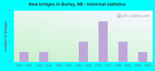
- New bridges - historical statistics
- 11930-1939
- 11940-1949
- 21960-1969
- 41970-1979
- 21980-1989
- 11990-1999
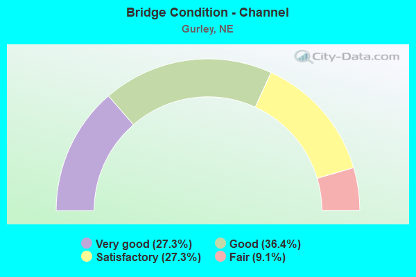
- Bridge Condition - Channel
- 27.3%Very good
- 36.4%Good
- 27.3%Satisfactory
- 9.1%Fair
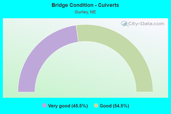
- Bridge Condition - Culverts
- 45.5%Very good
- 54.5%Good
Find on map >> Show street view
Structure Number: C00170141, Location: 2N 1.5W GURLEY (Lat: 41.351700, Lng: -103.003300), Route carried "on" structure: County highway 14, Year Built: 1964, Status: Open, Structure Length: 0.67m (2.20ft), Average Daily Traffic: 30 (year 1999), Average Future Daily Traffic: 51 (year 2033), Features Intersected: STREAM, Facility Carried by Structure: CO RD 50 MI 50109
Minimum Vertical Clearance: 30+ m (98+ ft), Kilometerpoint: 0.000, Lanes on structure: 2, Owner: County Highway Agency, Approaching Roadway Width: 6.7m (22.0ft), Material/Design: Concrete, Design/Construction: Culvert, Number Of Spans In Main Unit: 2, Length of Maximum Span: 3.0m (9.8ft)
Condition: Channel: Fair, Culverts: Good, Operating Rating: 33.0 metric tons, Method Used To Determine Operating Rating: Field evaluation and documented engineering judgment, Inventory Rating: 22.0 metric tons, Method Used To Determine Inventory Rating: Field evaluation and documented engineering judgment, Structural Evaluation: Equal to present minimum criteria, Waterway Adequacy: Somewhat better than minimum adequacy, Approach Roadway Alignment: Better than present minimum criteria, Designated Inspection Frequency: Every 24 months, Inspection Date: November 2021
Find on map >> Show street view
Structure Number: C001701805, Location: WJCT US385/US30 12N 2.5W (Lat: 41.323300, Lng: -102.993300), Route carried "on" structure: County highway 1140, Year Built: 1946, Status: Open, Structure Length: 1.31m (4.30ft), Average Daily Traffic: 190 (year 2011), Average Future Daily Traffic: 190 (year 2033), Features Intersected: RUSH CREEK, Facility Carried by Structure: CO RD 46 MI 46109
Minimum Vertical Clearance: 30+ m (98+ ft), Kilometerpoint: 3.960, Lanes on structure: 2, Owner: County Highway Agency, Approaching Roadway Width: 6.4m (21.0ft), Skew: 3 degrees, Material/Design: Concrete, Design/Construction: Culvert, Number Of Spans In Main Unit: 3, Length of Maximum Span: 3.7m (12.1ft), Curb-To-Curb Width: 6.1m (20.0ft), Out-to-Out Width: 10.4m (34.1ft)
Condition: Channel: Good, Culverts: Very good, Operating Rating: 33.0 metric tons, Method Used To Determine Operating Rating: Field evaluation and documented engineering judgment, Inventory Rating: 22.0 metric tons, Method Used To Determine Inventory Rating: Field evaluation and documented engineering judgment, Structural Evaluation: Equal to present minimum criteria, Deck Geometry: Meets minimum limits, Waterway Adequacy: Equal to present minimum criteria, Approach Roadway Alignment: Equal to present minimum criteria, Designated Inspection Frequency: Every 24 months, Inspection Date: October 2020
Find on map >> Show street view
Structure Number: C00170181, Location: WJCT US385/US30 12N .4E (Lat: 41.323000, Lng: -102.938900), Route carried "on" structure: County highway 1140, Year Built: 1964, Status: Open, Structure Length: 1.01m (3.31ft), Average Daily Traffic: 230 (year 2011), Average Future Daily Traffic: 230 (year 2033), Features Intersected: DRY WASH, Facility Carried by Structure: CO RD 46 MI 46115
Minimum Vertical Clearance: 30+ m (98+ ft), Kilometerpoint: 4.299, Lanes on structure: 2, Owner: County Highway Agency, Approaching Roadway Width: 7.0m (23.0ft), Material/Design: Concrete, Design/Construction: Culvert, Number Of Spans In Main Unit: 3, Length of Maximum Span: 3.0m (9.8ft)
Condition: Channel: Satisfactory, Culverts: Good, Operating Rating: 33.0 metric tons, Method Used To Determine Operating Rating: Field evaluation and documented engineering judgment, Inventory Rating: 22.0 metric tons, Method Used To Determine Inventory Rating: Field evaluation and documented engineering judgment, Structural Evaluation: Equal to present minimum criteria, Waterway Adequacy: Somewhat better than minimum adequacy, Approach Roadway Alignment: Equal to present desirable criteria, Designated Inspection Frequency: Every 24 months, Inspection Date: November 2021
Find on map >> Show street view
Structure Number: C001702005, Location: .6S .5W GURLEY (Lat: 41.308600, Lng: -102.984200), Route carried "on" structure: County highway 20, Year Built: 1983, Status: Open, Structure Length: 1.16m (3.81ft), Average Daily Traffic: 15 (year 2003), Average Future Daily Traffic: 25 (year 2033), Features Intersected: RUSH CREEK, Facility Carried by Structure: CO RD 44 MI 44111
Minimum Vertical Clearance: 30+ m (98+ ft), Kilometerpoint: 0.000, Lanes on structure: 2, Owner: County Highway Agency, Approaching Roadway Width: 5.8m (19.0ft), Material/Design: Concrete, Design/Construction: Culvert, Number Of Spans In Main Unit: 3, Length of Maximum Span: 3.7m (12.1ft)
Condition: Channel: Good, Culverts: Very good, Operating Rating: 33.0 metric tons, Method Used To Determine Operating Rating: Field evaluation and documented engineering judgment, Inventory Rating: 22.0 metric tons, Method Used To Determine Inventory Rating: Field evaluation and documented engineering judgment, Structural Evaluation: Equal to present minimum criteria, Waterway Adequacy: Better than present minimum criteria, Approach Roadway Alignment: Better than present minimum criteria, Designated Inspection Frequency: Every 24 months, Inspection Date: November 2021
Find on map >> Show street view
Structure Number: C001724104, Location: 1W 3S GURLEY (Lat: 41.271700, Lng: -102.991700), Route carried "on" structure: County highway 241, Year Built: 1974, Status: Open, Structure Length: 0.67m (2.20ft), Average Daily Traffic: 30 (year 2003), Average Future Daily Traffic: 51 (year 2033), Features Intersected: STREAM, Facility Carried by Structure: CO RD 111 MI 11138
Minimum Vertical Clearance: 30+ m (98+ ft), Kilometerpoint: 0.000, Lanes on structure: 2, Owner: County Highway Agency, Approaching Roadway Width: 6.1m (20.0ft), Material/Design: Concrete, Design/Construction: Culvert, Number Of Spans In Main Unit: 2, Length of Maximum Span: 3.0m (9.8ft), Curb-To-Curb Width: 10.6m (34.8ft), Out-to-Out Width: 11.0m (36.1ft)
Condition: Channel: Good, Culverts: Very good, Operating Rating: 33.0 metric tons, Method Used To Determine Operating Rating: Field evaluation and documented engineering judgment, Inventory Rating: 22.0 metric tons, Method Used To Determine Inventory Rating: Field evaluation and documented engineering judgment, Structural Evaluation: Equal to present minimum criteria, Deck Geometry: Superior to present desirable criteria, Waterway Adequacy: Equal to present minimum criteria, Approach Roadway Alignment: Better than present minimum criteria, Designated Inspection Frequency: Every 24 months, Inspection Date: November 2021
Find on map >> Show street view
Structure Number: C001724105, Location: 1W .1S GURLEY (Lat: 41.321700, Lng: -102.991700), Route carried "on" structure: County highway 241, Year Built: 1978, Status: Open, Structure Length: 1.10m (3.61ft), Average Daily Traffic: 30 (year 2003), Average Future Daily Traffic: 51 (year 2033), Design Load: HS 20, Features Intersected: RUSH CREEK, Facility Carried by Structure: CO RD 111 MI 11144
Minimum Vertical Clearance: 30+ m (98+ ft), Kilometerpoint: 0.000, Lanes on structure: 2, Owner: County Highway Agency, Approaching Roadway Width: 5.8m (19.0ft), Skew: 3 degrees, Material/Design: Concrete, Design/Construction: Culvert, Number Of Spans In Main Unit: 3, Length of Maximum Span: 3.0m (9.8ft), Curb-To-Curb Width: 5.5m (18.0ft), Out-to-Out Width: 9.6m (31.5ft)
Condition: Channel: Satisfactory, Culverts: Very good, Operating Rating: 33.0 metric tons, Method Used To Determine Operating Rating: Field evaluation and documented engineering judgment, Inventory Rating: 22.0 metric tons, Method Used To Determine Inventory Rating: Field evaluation and documented engineering judgment, Structural Evaluation: Equal to present minimum criteria, Deck Geometry: Meets minimum limits, Waterway Adequacy: Equal to present minimum criteria, Approach Roadway Alignment: Equal to present desirable criteria, Designated Inspection Frequency: Every 24 months, Inspection Date: October 2020
Find on map >> Show street view
Structure Number: C00173471, Location: 2E 9.5N SIDNEY (Lat: 41.286700, Lng: -102.935000), Route carried "on" structure: County highway 347, Year Built: 1992, Status: Open, Structure Length: 1.34m (4.40ft), Average Daily Traffic: 20 (year 2003), Average Future Daily Traffic: 34 (year 2033), Design Load: HS 20, Features Intersected: RUSH CREEK, Facility Carried by Structure: CO RD 117 MI 11740
Minimum Vertical Clearance: 30+ m (98+ ft), Kilometerpoint: 0.000, Lanes on structure: 2, Owner: County Highway Agency, Approaching Roadway Width: 6.7m (22.0ft), Skew: 2 degrees, Material/Design: Concrete, Design/Construction: Culvert, Number Of Spans In Main Unit: 4, Length of Maximum Span: 3.0m (9.8ft), Curb-To-Curb Width: 14.3m (46.9ft), Out-to-Out Width: 14.3m (46.9ft)
Condition: Channel: Good, Culverts: Very good, Operating Rating: 33.0 metric tons, Method Used To Determine Operating Rating: Field evaluation and documented engineering judgment, Inventory Rating: 22.0 metric tons, Method Used To Determine Inventory Rating: Field evaluation and documented engineering judgment, Structural Evaluation: Equal to present minimum criteria, Deck Geometry: Superior to present desirable criteria, Waterway Adequacy: Equal to present desirable criteria, Approach Roadway Alignment: Equal to present desirable criteria, Designated Inspection Frequency: Every 24 months, Inspection Date: October 2020
Find on map >> Show street view
Structure Number: C001753725, Location: 3W GURLEY (Lat: 41.323300, Lng: -103.030000), Route carried "on" structure: County highway 537, Year Built: 1974, Status: Open, Structure Length: 1.01m (3.31ft), Average Daily Traffic: 45 (year 2003), Average Future Daily Traffic: 76 (year 2033), Design Load: HS 20, Features Intersected: RUSH CREEK, Facility Carried by Structure: CO RD 107 MI 10746
Minimum Vertical Clearance: 30+ m (98+ ft), Kilometerpoint: 0.000, Lanes on structure: 2, Owner: County Highway Agency, Approaching Roadway Width: 6.1m (20.0ft), Material/Design: Concrete, Design/Construction: Culvert, Number Of Spans In Main Unit: 3, Length of Maximum Span: 3.0m (9.8ft), Out-to-Out Width: 11.0m (36.1ft)
Condition: Channel: Satisfactory, Culverts: Good, Operating Rating: 33.0 metric tons, Method Used To Determine Operating Rating: Field evaluation and documented engineering judgment, Inventory Rating: 22.0 metric tons, Method Used To Determine Inventory Rating: Field evaluation and documented engineering judgment, Structural Evaluation: Equal to present minimum criteria, Waterway Adequacy: Equal to present minimum criteria, Approach Roadway Alignment: Equal to present minimum criteria, Designated Inspection Frequency: Every 24 months, Inspection Date: October 2020
Find on map >> Show street view
Structure Number: S385 04504, Location: 1S GURLEY (Lat: 41.304600, Lng: -102.973500), Route carried "on" structure: US 385, Year Built: 1979, Status: Open, Structure Length: 1.16m (3.81ft), Average Daily Traffic: 2,730 (year 2018), Truck Traffic: 15%, Average Future Daily Traffic: 3,822 (year 2038), Design Load: HS 20, Features Intersected: RUSH CREEK
Minimum Vertical Clearance: 30+ m (98+ ft), Kilometerpoint: 7.248, Lanes on structure: 2, Base Highway Network: Yes, Owner: State Highway Agency, Approaching Roadway Width: 12.2m (40.0ft), Skew: 1 degrees, Material/Design: Concrete, Design/Construction: Culvert, Number Of Spans In Main Unit: 3, Length of Maximum Span: 3.7m (12.1ft)
Condition: Channel: Very good, Culverts: Good, Operating Rating: 33.0 metric tons, Method Used To Determine Operating Rating: Field evaluation and documented engineering judgment, Inventory Rating: 22.0 metric tons, Method Used To Determine Inventory Rating: Field evaluation and documented engineering judgment, Structural Evaluation: Somewhat better than minimum adequacy, Waterway Adequacy: Equal to present desirable criteria, Approach Roadway Alignment: Equal to present desirable criteria, Designated Inspection Frequency: Every 24 months, Inspection Date: September 2021
Find on map >> Show street view
Structure Number: S385 04802, Location: 2N GURLEY (Lat: 41.347800, Lng: -102.973200), Route carried "on" structure: US 385, Year Built: 1989, Year Reconstructed: 1993, Status: Open, Structure Length: 0.82m (2.69ft), Average Daily Traffic: 2,365 (year 2018), Truck Traffic: 16%, Average Future Daily Traffic: 3,311 (year 2038), Design Load: HS 20, Features Intersected: RUSH CREEK TRIBUTARY
Minimum Vertical Clearance: 30+ m (98+ ft), Kilometerpoint: 7.728, Lanes on structure: 2, Base Highway Network: Yes, Owner: State Highway Agency, Approaching Roadway Width: 12.2m (40.0ft), Skew: 2 degrees, Material/Design: Concrete, Design/Construction: Culvert, Number Of Spans In Main Unit: 3, Length of Maximum Span: 2.4m (7.9ft)
Condition: Channel: Very good, Culverts: Good, Operating Rating: 33.0 metric tons, Method Used To Determine Operating Rating: Field evaluation and documented engineering judgment, Inventory Rating: 22.0 metric tons, Method Used To Determine Inventory Rating: Field evaluation and documented engineering judgment, Structural Evaluation: Somewhat better than minimum adequacy, Waterway Adequacy: Equal to present desirable criteria, Approach Roadway Alignment: Equal to present desirable criteria, Designated Inspection Frequency: Every 24 months, Inspection Date: September 2021
Find on map >> Show street view
Structure Number: S385 04886, Location: 3N GURLEY (Lat: 41.359900, Lng: -102.973100), Route carried "on" structure: US 385, Year Built: 1938, Year Reconstructed: 1993, Status: Open, Structure Length: 0.64m (2.10ft), Average Daily Traffic: 2,365 (year 2018), Truck Traffic: 16%, Average Future Daily Traffic: 3,311 (year 2038), Design Load: HS 20, Features Intersected: RUSH CREEK TRIBUTARY
Minimum Vertical Clearance: 30+ m (98+ ft), Kilometerpoint: 7.863, Lanes on structure: 2, Base Highway Network: Yes, Owner: State Highway Agency, Approaching Roadway Width: 12.2m (40.0ft), Material/Design: Concrete, Design/Construction: Culvert, Number Of Spans In Main Unit: 2, Length of Maximum Span: 3.0m (9.8ft)
Condition: Channel: Very good, Culverts: Good, Operating Rating: 33.0 metric tons, Method Used To Determine Operating Rating: Field evaluation and documented engineering judgment, Inventory Rating: 22.0 metric tons, Method Used To Determine Inventory Rating: Field evaluation and documented engineering judgment, Structural Evaluation: Somewhat better than minimum adequacy, Waterway Adequacy: Equal to present desirable criteria, Approach Roadway Alignment: Equal to present desirable criteria, Designated Inspection Frequency: Every 24 months, Inspection Date: September 2021