Bridge Statistics for Hackleburg, Alabama (AL)
Condition, Traffic, Stress, Structural Evaluation, Project Costs
- National Bridge Inventory (NBI) Statistics
- 19Number of bridges
- 518ft / 158mTotal length
- $52,772,000Total costs
- 21,784Total average daily traffic
- 1,790Total average daily truck traffic
- 28,970Total future (year 2030) average daily traffic
- National Bridge Inventory (NBI) Registered Bridges for Hackleburg
- No street view available for this location
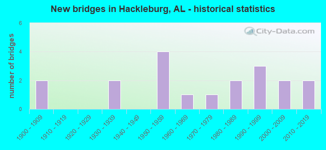
- New bridges - historical statistics
- 21900-1909
- 21930-1939
- 41950-1959
- 11960-1969
- 11970-1979
- 21980-1989
- 31990-1999
- 22000-2009
- 22010-2019
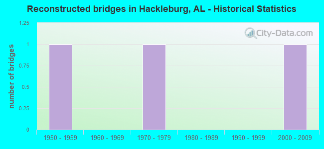
- Reconstructed bridges - Historical Statistics
- 11950-1959
- 01960-1969
- 11970-1979
- 01980-1989
- 01990-1999
- 12000-2009
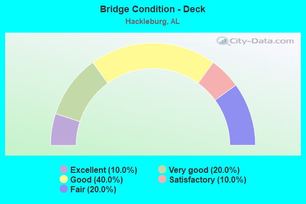
- Bridge Condition - Deck
- 10.0%Excellent
- 20.0%Very good
- 40.0%Good
- 10.0%Satisfactory
- 20.0%Fair
- Bridge Condition - Superstructure
- 30.0%Very good
- 20.0%Good
- 30.0%Satisfactory
- 20.0%Fair

- Bridge Condition - Substructure
- 30.0%Very good
- 20.0%Good
- 30.0%Satisfactory
- 20.0%Fair
- Bridge Condition - Channel
- 35.3%Very good
- 35.3%Good
- 23.5%Satisfactory
- 5.9%Poor
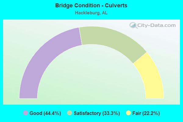
- Bridge Condition - Culverts
- 44.4%Good
- 33.3%Satisfactory
- 22.2%Fair
Find on map >> Show street view
Structure Number: 1306, Location: 500 FT WEST OF I65 (Lat: 32.377592, Lng: -86.323797), Route carried "on" structure: City street , Year Built: 1935, Status: Open, Structure Length: 8.23m (27.00ft), Average Daily Traffic: 6,980 (year 1990), Truck Traffic: 3%, Average Future Daily Traffic: 10,100 (year 2038), Design Load: H 20, Features Intersected: SCLLN RR, Facility Carried by Structure: Maxwell Blvd.
Minimum Vertical Clearance: 5.26m (17.26ft), Kilometerpoint: 3.499, Lanes on structure: 4, Owner: City or Municipal Highway Agency, Approaching Roadway Width: 15.2m (49.9ft), Skew: 23 degrees, Material/Design: Concrete, Design/Construction: Tee Beam, Number Of Spans In Main Unit: 4, Length of Maximum Span: 28.7m (94.2ft), Curb or Sidewalk Widths: Left: 1.5m (4.9ft), Right: 1.5m (4.9ft), Curb-To-Curb Width: 15.2m (49.9ft), Out-to-Out Width: 18.7m (61.4ft)
Condition: Deck: Fair, Superstructure: Fair, Substructure: Fair, Operating Rating: 68.6 metric tons, Method Used To Determine Operating Rating: Load Factor (LF), Inventory Rating: 41.1 metric tons, Method Used To Determine Inventory Rating: Load Factor (LF), Structural Evaluation: Somewhat better than minimum adequacy, Deck Geometry: High priority of corrective action, Underclear: Meets minimum limits, Approach Roadway Alignment: Equal to present minimum criteria, Length Of Structure Improvement: 9.23m (30.28ft), Designated Inspection Frequency: Every 24 months, Inspection Date: December 2020, Bridge Improvement Cost: $3,860,000, Roadway Improvement Cost: $386,000, Total Project Cost: $4,246,000 ( Estimate for 2022), Deck Structure Type: Concrete Cast-file-Place
Find on map >> Show street view
Structure Number: 4477, Location: 4 MI N JCT US 278 (Lat: 34.170361, Lng: -87.827917), Route carried "on" structure: State highway 253, Year Built: 1952, Year Reconstructed: 2011, Status: Open, Structure Length: 0.67m (2.20ft), Average Daily Traffic: 210 (year 2017), Truck Traffic: 10%, Average Future Daily Traffic: 293 (year 2041), Design Load: H 15, Features Intersected: Little Camp Creek
Minimum Vertical Clearance: 30+ m (98+ ft), Kilometerpoint: 34.675, Lanes on structure: 2, Owner: State Highway Agency, Approaching Roadway Width: 5.2m (17.1ft), Material/Design: Concrete, Design/Construction: Culvert, Number Of Spans In Main Unit: 2, Length of Maximum Span: 3.0m (9.8ft)
Condition: Channel: Very good, Culverts: Good, Operating Rating: 67.1 metric tons, Method Used To Determine Operating Rating: Load Factor (LF), Inventory Rating: 39.9 metric tons, Method Used To Determine Inventory Rating: Load Factor (LF), Structural Evaluation: Better than present minimum criteria, Waterway Adequacy: Better than present minimum criteria, Approach Roadway Alignment: Equal to present minimum criteria, Length Of Structure Improvement: 1.30m (4.27ft), Designated Inspection Frequency: Every 24 months, Inspection Date: April 2021, Bridge Improvement Cost: $360,000, Roadway Improvement Cost: $36,000, Total Project Cost: $396,000 ( Estimate for 2022)
Find on map >> Show street view
Structure Number: 5145, Location: .8 MI SW US 43 CO 8 JCT (Lat: 34.327722, Lng: -87.781556), Route carried "on" structure: County highway 8, Year Built: 1955, Status: Posted for load, Structure Length: 1.43m (4.69ft), Average Daily Traffic: 140 (year 1986), Truck Traffic: 5%, Average Future Daily Traffic: 281 (year 2031), Features Intersected: DISMAL BRANCH
Minimum Vertical Clearance: 30+ m (98+ ft), Kilometerpoint: 0.010, Lanes on structure: 2, Owner: County Highway Agency, Approaching Roadway Width: 8.5m (27.9ft), Material/Design: Wood or Timber, Design/Construction: Stringer/Multi-beam, Number Of Spans In Main Unit: 3, Length of Maximum Span: 4.6m (15.1ft), Curb-To-Curb Width: 6.0m (19.7ft), Out-to-Out Width: 6.6m (21.7ft)
Condition: Deck: Satisfactory, Superstructure: Satisfactory, Substructure: Satisfactory, Channel: Poor, Operating Rating: 15.6 metric tons, Method Used To Determine Operating Rating: Allowable Stress (AS), Inventory Rating: 10.8 metric tons, Method Used To Determine Inventory Rating: Allowable Stress (AS), Structural Evaluation: Meets minimum limits, Deck Geometry: High priority of corrective action, Waterway Adequacy: Equal to present desirable criteria, Approach Roadway Alignment: Equal to present minimum criteria, Bridge Posting: Required (Relationship of Operating Rating to Maximum Legal Load: > 39.9% below), Length Of Structure Improvement: 2.11m (6.92ft), Designated Inspection Frequency: Every 24 months, Other Special Inspection Frequency: Every 12 months, Inspection Date: Febuary 2021, Other Special Inspection Date: Febuary 2022, Bridge Improvement Cost: $303,000, Roadway Improvement Cost: $30,000, Total Project Cost: $333,000 ( Estimate for 2022), Deck Structure Type: Concrete Cast-file-Place
Find on map >> Show street view
Structure Number: 5498, Location: 3 MI SOUTH OF US 80 (Lat: 32.234725, Lng: -86.746922), Route carried "on" structure: County highway 17, Year Built: 1956, Status: Open, Structure Length: 0.67m (2.20ft), Average Daily Traffic: 415 (year 2003), Truck Traffic: 5%, Average Future Daily Traffic: 480 (year 2030), Design Load: H 15, Features Intersected: BUCK CREEK
Minimum Vertical Clearance: 30+ m (98+ ft), Kilometerpoint: 0.010, Lanes on structure: 2, Base Highway Network: Yes, Owner: County Highway Agency, Approaching Roadway Width: 8.5m (27.9ft), Material/Design: Concrete, Design/Construction: Culvert, Number Of Spans In Main Unit: 2, Length of Maximum Span: 3.0m (9.8ft)
Condition: Channel: Good, Culverts: Good, Operating Rating: 88.9 metric tons, Method Used To Determine Operating Rating: Load Factor (LF), Inventory Rating: 64.0 metric tons, Method Used To Determine Inventory Rating: Load Factor (LF), Structural Evaluation: Better than present minimum criteria, Waterway Adequacy: Equal to present minimum criteria, Approach Roadway Alignment: Better than present minimum criteria, Length Of Structure Improvement: 1.30m (4.27ft), Designated Inspection Frequency: Every 24 months, Inspection Date: Febuary 2021, Bridge Improvement Cost: $225,000, Roadway Improvement Cost: $23,000, Total Project Cost: $248,000 ( Estimate for 2022)
Find on map >> Show street view
Structure Number: 5499, Location: 2 MI SOUTH OF US 80 (Lat: 32.248864, Lng: -86.752417), Route carried "on" structure: County highway 17, Year Built: 1956, Status: Open, Structure Length: 0.67m (2.20ft), Average Daily Traffic: 415 (year 2003), Truck Traffic: 5%, Average Future Daily Traffic: 480 (year 2030), Design Load: H 15, Features Intersected: BUCK CREEK
Minimum Vertical Clearance: 30+ m (98+ ft), Kilometerpoint: 0.010, Lanes on structure: 2, Base Highway Network: Yes, Owner: County Highway Agency, Approaching Roadway Width: 8.5m (27.9ft), Material/Design: Concrete, Design/Construction: Culvert, Number Of Spans In Main Unit: 2, Length of Maximum Span: 3.0m (9.8ft)
Condition: Channel: Good, Culverts: Good, Operating Rating: 57.3 metric tons, Method Used To Determine Operating Rating: Load Factor (LF), Inventory Rating: 34.4 metric tons, Method Used To Determine Inventory Rating: Load Factor (LF), Structural Evaluation: Better than present minimum criteria, Waterway Adequacy: Equal to present minimum criteria, Approach Roadway Alignment: Better than present minimum criteria, Length Of Structure Improvement: 1.30m (4.27ft), Designated Inspection Frequency: Every 24 months, Inspection Date: Febuary 2021, Bridge Improvement Cost: $233,000, Roadway Improvement Cost: $23,000, Total Project Cost: $256,000 ( Estimate for 2022)
Find on map >> Show street view
Structure Number: 7346, Location: 6.4 MILE NW OF ELBA (Lat: 31.477836, Lng: -86.142147), Route carried "on" structure: County highway 353, Year Built: 1961, Status: Open, Structure Length: 1.83m (6.00ft), Average Daily Traffic: 250 (year 2020), Truck Traffic: 5%, Average Future Daily Traffic: 350 (year 2040), Design Load: H 10, Features Intersected: BEAVERDAM CREEK
Minimum Vertical Clearance: 30+ m (98+ ft), Kilometerpoint: 0.010, Lanes on structure: 2, Owner: County Highway Agency, Approaching Roadway Width: 9.1m (29.9ft), Material/Design: Concrete, Design/Construction: Culvert, Number Of Spans In Main Unit: 5, Length of Maximum Span: 3.7m (12.1ft)
Condition: Channel: Satisfactory, Culverts: Satisfactory, Operating Rating: 46.3 metric tons, Method Used To Determine Operating Rating: Load Factor (LF), Inventory Rating: 27.7 metric tons, Method Used To Determine Inventory Rating: Load Factor (LF), Structural Evaluation: Equal to present minimum criteria, Waterway Adequacy: Better than present minimum criteria, Approach Roadway Alignment: Better than present minimum criteria, Length Of Structure Improvement: 2.54m (8.33ft), Designated Inspection Frequency: Every 24 months, Inspection Date: August 2020, Bridge Improvement Cost: $470,000, Roadway Improvement Cost: $47,000, Total Project Cost: $517,000 ( Estimate for 2022)
Find on map >> Show street view
Structure Number: 7832, Location: 6 MILES SW OF HACKLEBURG (Lat: 34.265778, Lng: -87.924222), Route carried "on" structure: County highway 32, Year Built: 1900, Year Reconstructed: 1963, Status: Open, Structure Length: 0.79m (2.59ft), Average Daily Traffic: 105 (year 2001), Truck Traffic: 10%, Average Future Daily Traffic: 162 (year 2036), Design Load: H 15, Features Intersected: NORTH FORK
Minimum Vertical Clearance: 30+ m (98+ ft), Kilometerpoint: 0.010, Lanes on structure: 2, Owner: County Highway Agency, Approaching Roadway Width: 7.3m (24.0ft), Skew: 3 degrees, Material/Design: Concrete, Design/Construction: Culvert, Number Of Spans In Main Unit: 2, Length of Maximum Span: 3.0m (9.8ft)
Condition: Channel: Good, Culverts: Fair, Operating Rating: 88.9 metric tons, Method Used To Determine Operating Rating: Load Factor (LF), Inventory Rating: 88.9 metric tons, Method Used To Determine Inventory Rating: Load Factor (LF), Structural Evaluation: Somewhat better than minimum adequacy, Waterway Adequacy: Superior to present desirable criteria, Approach Roadway Alignment: Better than present minimum criteria, Length Of Structure Improvement: 1.44m (4.72ft), Designated Inspection Frequency: Every 24 months, Inspection Date: March 2020, Bridge Improvement Cost: $717,000, Roadway Improvement Cost: $72,000, Total Project Cost: $789,000 ( Estimate for 2022)
Find on map >> Show street view
Structure Number: 10363, Location: 0.4 MI N MARION CO LINE (Lat: 34.316797, Lng: -87.858333), Route carried "on" structure: County highway 57, Year Built: 1970, Status: Open, Structure Length: 11.58m (37.99ft), Average Daily Traffic: 110 (year 1986), Truck Traffic: 4%, Average Future Daily Traffic: 282 (year 2031), Design Load: HS 20, Features Intersected: BEAR CREEK
Minimum Vertical Clearance: 30+ m (98+ ft), Kilometerpoint: 0.010, Lanes on structure: 2, Owner: County Highway Agency, Approaching Roadway Width: 7.3m (24.0ft), Skew: 4 degrees, Material/Design: Steel continuous, Design/Construction: Stringer/Multi-beam, Number Of Spans In Main Unit: 3, Number Of Approach Spans: 2, Length of Maximum Span: 24.4m (80.1ft), Curb-To-Curb Width: 8.5m (27.9ft), Out-to-Out Width: 9.7m (31.8ft)
Condition: Deck: Good, Superstructure: Fair, Substructure: Satisfactory, Channel: Good, Operating Rating: 80.0 metric tons, Method Used To Determine Operating Rating: Load Factor (LF), Inventory Rating: 47.9 metric tons, Method Used To Determine Inventory Rating: Load Factor (LF), Structural Evaluation: Somewhat better than minimum adequacy, Deck Geometry: Equal to present minimum criteria, Waterway Adequacy: Superior to present desirable criteria, Approach Roadway Alignment: Equal to present desirable criteria, Length Of Structure Improvement: 12.45m (40.85ft), Designated Inspection Frequency: Every 24 months, Inspection Date: March 2021, Bridge Improvement Cost: $2,646,000, Roadway Improvement Cost: $265,000, Total Project Cost: $2,911,000 ( Estimate for 2022), Deck Structure Type: Concrete Cast-file-Place
Find on map >> Show street view
Structure Number: 12449, Location: 1 MILE NORTH JCT CO 41 (Lat: 34.247028, Lng: -87.913833), Route carried "on" structure: County highway , Year Built: 1900, Year Reconstructed: 1981, Status: Open, Structure Length: 0.98m (3.22ft), Average Daily Traffic: 60 (year 2001), Average Future Daily Traffic: 101 (year 2036), Design Load: H 20, Features Intersected: NORTH FORK CREEK, Facility Carried by Structure: CR 167
Minimum Vertical Clearance: 30+ m (98+ ft), Kilometerpoint: 0.010, Lanes on structure: 2, Owner: County Highway Agency, Approaching Roadway Width: 8.5m (27.9ft), Material/Design: Concrete, Design/Construction: Culvert, Number Of Spans In Main Unit: 3, Length of Maximum Span: 3.0m (9.8ft)
Condition: Channel: Satisfactory, Culverts: Satisfactory, Operating Rating: 74.1 metric tons, Method Used To Determine Operating Rating: Load Factor (LF), Inventory Rating: 44.5 metric tons, Method Used To Determine Inventory Rating: Load Factor (LF), Structural Evaluation: Equal to present minimum criteria, Waterway Adequacy: Superior to present desirable criteria, Approach Roadway Alignment: Better than present minimum criteria, Length Of Structure Improvement: 1.65m (5.41ft), Designated Inspection Frequency: Every 24 months, Inspection Date: March 2020, Bridge Improvement Cost: $306,000, Roadway Improvement Cost: $31,000, Total Project Cost: $337,000 ( Estimate for 2022)
Find on map >> Show street view
Structure Number: 1315, Location: 2.8 MILES SOUTH JCTCO 12 (Lat: 34.210222, Lng: -87.788306), Route carried "on" structure: County highway , Year Built: 1984, Status: Open, Structure Length: 1.13m (3.71ft), Average Daily Traffic: 25 (year 2001), Average Future Daily Traffic: 59 (year 2035), Design Load: H 20, Features Intersected: Barn Creek, Facility Carried by Structure: Grady Cole Road
Minimum Vertical Clearance: 30+ m (98+ ft), Kilometerpoint: 0.010, Lanes on structure: 2, Owner: County Highway Agency, Approaching Roadway Width: 8.5m (27.9ft), Skew: 3 degrees, Material/Design: Concrete, Design/Construction: Culvert, Number Of Spans In Main Unit: 3, Length of Maximum Span: 3.0m (9.8ft)
Condition: Channel: Satisfactory, Culverts: Satisfactory, Operating Rating: 69.9 metric tons, Method Used To Determine Operating Rating: Load Factor (LF), Inventory Rating: 41.9 metric tons, Method Used To Determine Inventory Rating: Load Factor (LF), Structural Evaluation: Equal to present minimum criteria, Waterway Adequacy: Better than present minimum criteria, Approach Roadway Alignment: Better than present minimum criteria, Length Of Structure Improvement: 1.81m (5.94ft), Designated Inspection Frequency: Every 24 months, Inspection Date: September 2021, Bridge Improvement Cost: $313,000, Roadway Improvement Cost: $31,000, Total Project Cost: $344,000 ( Estimate for 2022)
Find on map >> Show street view
Structure Number: 13438, Location: 1.5MILES SOUTH JCT.172 (Lat: 34.252683, Lng: -87.789944), Route carried "on" structure: County highway 12, Year Built: 1985, Status: Open, Structure Length: 4.72m (15.49ft), Average Daily Traffic: 115 (year 2001), Truck Traffic: 5%, Average Future Daily Traffic: 318 (year 2035), Design Load: HS 20, Features Intersected: Old RR Bed
Minimum Vertical Clearance: 30+ m (98+ ft), Kilometerpoint: 0.010, Lanes on structure: 2, Owner: County Highway Agency, Approaching Roadway Width: 10.4m (34.1ft), Material/Design: Prestressed concrete continuous, Design/Construction: Stringer/Multi-beam, Number Of Spans In Main Unit: 3, Length of Maximum Span: 16.8m (55.1ft), Curb-To-Curb Width: 8.5m (27.9ft), Out-to-Out Width: 9.4m (30.8ft)
Condition: Deck: Good, Superstructure: Satisfactory, Substructure: Fair, Operating Rating: 55.1 metric tons, Method Used To Determine Operating Rating: Load Factor (LF), Inventory Rating: 36.3 metric tons, Method Used To Determine Inventory Rating: Load Factor (LF), Structural Evaluation: Somewhat better than minimum adequacy, Deck Geometry: Equal to present minimum criteria, Underclear: Superior to present desirable criteria, Approach Roadway Alignment: Better than present minimum criteria, Length Of Structure Improvement: 5.73m (18.80ft), Designated Inspection Frequency: Every 24 months, Inspection Date: September 2021, Bridge Improvement Cost: $1,179,000, Roadway Improvement Cost: $118,000, Total Project Cost: $1,297,000 ( Estimate for 2022), Deck Structure Type: Concrete Cast-file-Place
Find on map >> Show street view
Structure Number: 15363, Location: 2 MILES WEST JCT 241 (Lat: 34.263583, Lng: -87.764194), Route carried "on" structure: County highway , Year Built: 1991, Status: Open, Structure Length: 0.98m (3.22ft), Average Daily Traffic: 125 (year 2005), Truck Traffic: 10%, Average Future Daily Traffic: 226 (year 2035), Design Load: HS 20, Features Intersected: BUSH CREEK, Facility Carried by Structure: GRAVEL ROAD
Minimum Vertical Clearance: 30+ m (98+ ft), Kilometerpoint: 0.010, Lanes on structure: 2, Owner: County Highway Agency, Approaching Roadway Width: 7.3m (24.0ft), Material/Design: Concrete, Design/Construction: Culvert, Number Of Spans In Main Unit: 3, Length of Maximum Span: 3.0m (9.8ft)
Condition: Channel: Satisfactory, Culverts: Fair, Operating Rating: 88.9 metric tons, Method Used To Determine Operating Rating: Load Factor (LF), Inventory Rating: 88.9 metric tons, Method Used To Determine Inventory Rating: Load Factor (LF), Structural Evaluation: Somewhat better than minimum adequacy, Waterway Adequacy: Better than present minimum criteria, Approach Roadway Alignment: Equal to present minimum criteria, Length Of Structure Improvement: 1.65m (5.41ft), Designated Inspection Frequency: Every 24 months, Inspection Date: September 2021, Bridge Improvement Cost: $477,000, Roadway Improvement Cost: $48,000, Total Project Cost: $525,000 ( Estimate for 2022)
Find on map >> Show street view
Structure Number: 15482, Location: 5 MI N JCT AL-118 (Lat: 34.174750, Lng: -87.838611), Route carried "on" structure: State highway 253, Year Built: 1991, Status: Open, Structure Length: 1.83m (6.00ft), Average Daily Traffic: 222 (year 2020), Truck Traffic: 14%, Average Future Daily Traffic: 293 (year 2041), Design Load: HS 20, Features Intersected: Camp Creek
Minimum Vertical Clearance: 30+ m (98+ ft), Kilometerpoint: 35.821, Lanes on structure: 2, Owner: State Highway Agency, Approaching Roadway Width: 5.2m (17.1ft), Material/Design: Concrete, Design/Construction: Culvert, Number Of Spans In Main Unit: 4, Length of Maximum Span: 4.3m (14.1ft)
Condition: Channel: Very good, Culverts: Good, Operating Rating: 51.1 metric tons, Method Used To Determine Operating Rating: Load Factor (LF), Inventory Rating: 30.7 metric tons, Method Used To Determine Inventory Rating: Load Factor (LF), Structural Evaluation: Better than present minimum criteria, Waterway Adequacy: Equal to present desirable criteria, Approach Roadway Alignment: Better than present minimum criteria, Length Of Structure Improvement: 2.54m (8.33ft), Designated Inspection Frequency: Every 24 months, Inspection Date: April 2021, Bridge Improvement Cost: $646,000, Roadway Improvement Cost: $65,000, Total Project Cost: $711,000 ( Estimate for 2022)
Find on map >> Show street view
Structure Number: 15976, Location: 4 MI E JCT US-43 (Lat: 34.283444, Lng: -87.774250), Route carried "on" structure: State highway 172, Year Built: 1994, Status: Open, Structure Length: 9.14m (29.99ft), Average Daily Traffic: 1,000 (year 2020), Truck Traffic: 7%, Average Future Daily Traffic: 1,200 (year 2040), Design Load: HS 20, Features Intersected: Bear Creek
Minimum Vertical Clearance: 30+ m (98+ ft), Kilometerpoint: 30.681, Lanes on structure: 2, Owner: State Highway Agency, Approaching Roadway Width: 12.5m (41.0ft), Material/Design: Prestressed concrete, Design/Construction: Stringer/Multi-beam, Number Of Spans In Main Unit: 3, Length of Maximum Span: 30.5m (100.1ft), Curb-To-Curb Width: 12.1m (39.7ft), Out-to-Out Width: 13.0m (42.7ft)
Condition: Deck: Very good, Superstructure: Good, Substructure: Good, Channel: Very good, Operating Rating: 66.7 metric tons, Method Used To Determine Operating Rating: Load Factor (LF), Inventory Rating: 43.8 metric tons, Method Used To Determine Inventory Rating: Load Factor (LF), Structural Evaluation: Better than present minimum criteria, Deck Geometry: Better than present minimum criteria, Waterway Adequacy: Equal to present desirable criteria, Approach Roadway Alignment: Equal to present desirable criteria, Length Of Structure Improvement: 10.11m (33.17ft), Designated Inspection Frequency: Every 24 months, Inspection Date: January 2021, Bridge Improvement Cost: $2,910,000, Roadway Improvement Cost: $291,000, Total Project Cost: $3,201,000 ( Estimate for 2022), Deck Structure Type: Concrete Cast-file-Place
Find on map >> Show street view
Structure Number: 17206, Location: 0.5 MI. E. OF AL HWY 172 (Lat: 34.300889, Lng: -87.887917), Route carried "on" structure: County highway 116, Year Built: 1935, Status: Posted for load, Structure Length: 1.00m (3.28ft), Average Daily Traffic: 50 (year 2001), Average Future Daily Traffic: 66 (year 2035), Features Intersected: ROBINSON BRANCH
Minimum Vertical Clearance: 30+ m (98+ ft), Kilometerpoint: 0.000, Lanes on structure: 2, Owner: County Highway Agency, Approaching Roadway Width: 6.6m (21.7ft), Material/Design: Steel, Design/Construction: Stringer/Multi-beam, Number Of Spans In Main Unit: 1, Length of Maximum Span: 10.0m (32.8ft), Curb-To-Curb Width: 6.1m (20.0ft), Out-to-Out Width: 7.1m (23.3ft)
Condition: Deck: Fair, Superstructure: Satisfactory, Substructure: Satisfactory, Channel: Good, Operating Rating: 15.1 metric tons, Method Used To Determine Operating Rating: Load Factor (LF), Inventory Rating: 9.1 metric tons, Method Used To Determine Inventory Rating: Load Factor (LF), Structural Evaluation: High priority of corrective action, Deck Geometry: Somewhat better than minimum adequacy, Waterway Adequacy: Better than present minimum criteria, Approach Roadway Alignment: Better than present minimum criteria, Bridge Posting: Required (Relationship of Operating Rating to Maximum Legal Load: > 39.9% below), Length Of Structure Improvement: 1.67m (5.48ft), Designated Inspection Frequency: Every 24 months, Other Special Inspection Frequency: Every 12 months, Inspection Date: September 2021, Other Special Inspection Date: September 2021, Bridge Improvement Cost: $264,000, Roadway Improvement Cost: $26,000, Total Project Cost: $290,000 ( Estimate for 2022), Deck Structure Type: Concrete Cast-file-Place
Find on map >> Show street view
Structure Number: 18528, Location: N of Hackleburg (Lat: 34.295411, Lng: -87.803764), Route carried "on" structure: US ?????, Year Built: 2007, Status: Open, Structure Length: 41.15m (135.01ft), Average Daily Traffic: 4,021 (year 2020), Truck Traffic: 12%, Average Future Daily Traffic: 5,000 (year 2041), Design Load: HS 20, Features Intersected: Bear Creek, Facility Carried by Structure: AL-17
Minimum Vertical Clearance: 30+ m (98+ ft), Kilometerpoint: 472.315, Lanes on structure: 2, Owner: State Highway Agency, Approaching Roadway Width: 18.0m (59.1ft), Material/Design: Prestressed concrete, Design/Construction: Stringer/Multi-beam, Number Of Spans In Main Unit: 10, Length of Maximum Span: 41.1m (134.8ft), Curb-To-Curb Width: 12.2m (40.0ft), Out-to-Out Width: 13.1m (43.0ft)
Condition: Deck: Good, Superstructure: Good, Substructure: Very good, Channel: Very good, Operating Rating: 87.4 metric tons, Method Used To Determine Operating Rating: Load Factor (LF), Inventory Rating: 34.7 metric tons, Method Used To Determine Inventory Rating: Load Factor (LF), Structural Evaluation: Better than present minimum criteria, Deck Geometry: Better than present minimum criteria, Waterway Adequacy: Superior to present desirable criteria, Approach Roadway Alignment: Equal to present desirable criteria, Length Of Structure Improvement: 41.15m (135.01ft), Designated Inspection Frequency: Every 24 months, Inspection Date: March 2021, Bridge Improvement Cost: $12,132,000, Roadway Improvement Cost: $1,213,000, Total Project Cost: $13,345,000 ( Estimate for 2022), Deck Structure Type: Concrete Cast-file-Place
Find on map >> Show street view
Structure Number: 1854, Location: N of Hackleburg (Lat: 34.294928, Lng: -87.804461), Route carried "on" structure: US 43, Year Built: 2007, Status: Open, Structure Length: 41.15m (135.01ft), Average Daily Traffic: 4,021 (year 2019), Truck Traffic: 12%, Average Future Daily Traffic: 5,000 (year 2041), Design Load: HS 20, Features Intersected: Bear Creek, Facility Carried by Structure: AL-17
Minimum Vertical Clearance: 30+ m (98+ ft), Kilometerpoint: 472.315, Lanes on structure: 2, Owner: State Highway Agency, Approaching Roadway Width: 12.1m (39.7ft), Material/Design: Prestressed concrete, Design/Construction: Stringer/Multi-beam, Number Of Spans In Main Unit: 10, Length of Maximum Span: 41.1m (134.8ft), Curb-To-Curb Width: 12.1m (39.7ft), Out-to-Out Width: 12.9m (42.3ft)
Condition: Deck: Good, Superstructure: Very good, Substructure: Very good, Channel: Very good, Operating Rating: 87.4 metric tons, Method Used To Determine Operating Rating: Load Factor (LF), Inventory Rating: 34.7 metric tons, Method Used To Determine Inventory Rating: Load Factor (LF), Structural Evaluation: Equal to present desirable criteria, Deck Geometry: Better than present minimum criteria, Waterway Adequacy: Superior to present desirable criteria, Approach Roadway Alignment: Equal to present desirable criteria, Length Of Structure Improvement: 41.15m (135.01ft), Designated Inspection Frequency: Every 24 months, Inspection Date: March 2021, Bridge Improvement Cost: $11,850,000, Roadway Improvement Cost: $1,185,000, Total Project Cost: $13,035,000 ( Estimate for 2022), Deck Structure Type: Concrete Cast-file-Place
Find on map >> Show street view
Structure Number: 20594, Location: 4 MI N JCT AL-187 (Lat: 34.236917, Lng: -87.896969), Route carried "on" structure: US 43, Year Built: 2019, Status: Open, Structure Length: 28.80m (94.49ft), Average Daily Traffic: 3,350 (year 2020), Truck Traffic: 12%, Average Future Daily Traffic: 4,000 (year 2040), Design Load: HS 20, Features Intersected: North Fork Creek, Facility Carried by Structure: AL-17
Minimum Vertical Clearance: 0.00m, Kilometerpoint: 461.333, Lanes on structure: 2, Owner: State Highway Agency, Approaching Roadway Width: 13.4m (44.0ft), Material/Design: Steel continuous, Design/Construction: Stringer/Multi-beam, Number Of Spans In Main Unit: 1, Number Of Approach Spans: 3, Length of Maximum Span: 205.7m (674.9ft), Curb-To-Curb Width: 13.4m (44.0ft), Out-to-Out Width: 13.4m (44.0ft)
Condition: Deck: Very good, Superstructure: Very good, Substructure: Very good, Channel: Very good, Operating Rating: 36.5 metric tons, Method Used To Determine Operating Rating: Load Factor (LF), Inventory Rating: 21.9 metric tons, Method Used To Determine Inventory Rating: Load Factor (LF), Structural Evaluation: Somewhat better than minimum adequacy, Deck Geometry: High priority of corrective action, Waterway Adequacy: Equal to present desirable criteria, Approach Roadway Alignment: Equal to present desirable criteria, Length Of Structure Improvement: 28.80m (94.49ft), Designated Inspection Frequency: Every 24 months, Inspection Date: June 2021, Bridge Improvement Cost: $8,690,000, Roadway Improvement Cost: $869,000, Total Project Cost: $9,559,000 ( Estimate for 2022), Deck Structure Type: Concrete Cast-file-Place
Find on map >> Show street view
Structure Number: 20868, Location: 0.7 MI W. CO.8 JCT. (Lat: 34.346975, Lng: -87.806403), Route carried "on" structure: County highway 14, Year Built: 2013, Status: Open, Structure Length: 1.52m (4.99ft), Average Daily Traffic: 170 (year 2011), Truck Traffic: 2%, Average Future Daily Traffic: 279 (year 2036), Features Intersected: EDGAR BRANCH MILL POND, Facility Carried by Structure: NIX MILL POND RD
Minimum Vertical Clearance: 30+ m (98+ ft), Kilometerpoint: 0.010, Lanes on structure: 2, Owner: County Highway Agency, Approaching Roadway Width: 7.4m (24.3ft), Material/Design: Steel, Design/Construction: Stringer/Multi-beam, Number Of Spans In Main Unit: 1, Length of Maximum Span: 14.6m (47.9ft), Curb-To-Curb Width: 7.3m (24.0ft), Out-to-Out Width: 8.2m (26.9ft)
Condition: Deck: Excellent, Superstructure: Very good, Substructure: Good, Channel: Good, Operating Rating: 41.1 metric tons, Method Used To Determine Operating Rating: Load Factor (LF), Inventory Rating: 24.6 metric tons, Method Used To Determine Inventory Rating: Load Factor (LF), Structural Evaluation: Equal to present minimum criteria, Deck Geometry: Somewhat better than minimum adequacy, Waterway Adequacy: Better than present minimum criteria, Approach Roadway Alignment: High priority of corrective action, Length Of Structure Improvement: 2.20m (7.22ft), Designated Inspection Frequency: Every 24 months, Inspection Date: April 2020, Bridge Improvement Cost: $393,000, Roadway Improvement Cost: $39,000, Total Project Cost: $432,000 ( Estimate for 2022), Deck Structure Type: Concrete Cast-file-Place, Wearing Surface/Protective System: Wearing Surface: Low Slump Concrete