Bridge Statistics for Hagerman, Idaho (ID)
Condition, Traffic, Stress, Structural Evaluation, Project Costs
- National Bridge Inventory (NBI) Statistics
- 16Number of bridges
- 354ft / 108mTotal length
- $22,597,000Total costs
- 63,550Total average daily traffic
- 20,625Total average daily truck traffic
- National Bridge Inventory (NBI) Registered Bridges for Hagerman
- No street view available for this location
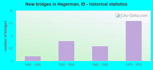
- New bridges - historical statistics
- 11940-1949
- 41950-1959
- 31960-1969
- 81970-1979
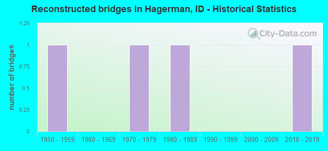
- Reconstructed bridges - Historical Statistics
- 11950-1959
- 01960-1969
- 11970-1979
- 11980-1989
- 01990-1999
- 02000-2009
- 12010-2019
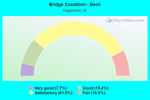
- Bridge Condition - Deck
- 7.7%Very good
- 15.4%Good
- 61.5%Satisfactory
- 15.4%Fair

- Bridge Condition - Superstructure
- 7.7%Very good
- 69.2%Satisfactory
- 23.1%Fair
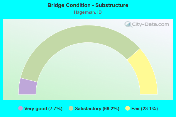
- Bridge Condition - Substructure
- 7.7%Very good
- 69.2%Satisfactory
- 23.1%Fair
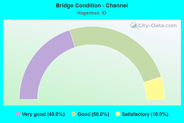
- Bridge Condition - Channel
- 40.0%Very good
- 50.0%Good
- 10.0%Satisfactory
Find on map >> Show street view
Structure Number: 1007, Location: AT KENDRICK NCL (Lat: 46.617833, Lng: -116.645861), Route carried "on" structure: State highway 3, Year Built: 1954, Year Reconstructed: 1961, Status: Open, Structure Length: 4.30m (14.11ft), Average Daily Traffic: 1,800 (year 2019), Truck Traffic: 25%, Average Future Daily Traffic: 2,700 (year 2039), Design Load: HS 15, Features Intersected: BIG BEAR CREEK
Minimum Vertical Clearance: 30+ m (98+ ft), Kilometerpoint: 21.483, Lanes on structure: 2, Base Highway Network: Yes (Inventory Route: SH0, Subroute: 1), Owner: State Highway Agency, Approaching Roadway Width: 8.5m (27.9ft), Material/Design: Concrete, Design/Construction: Stringer/Multi-beam, Number Of Spans In Main Unit: 3, Length of Maximum Span: 14.3m (46.9ft), Curb or Sidewalk Widths: Left: 1.7m (5.6ft), Right: 0.0m, Curb-To-Curb Width: 8.6m (28.2ft), Out-to-Out Width: 11.9m (39.0ft)
Condition: Deck: Good, Superstructure: Satisfactory, Substructure: Satisfactory, Channel: Good, Operating Rating: 38.1 metric tons, Method Used To Determine Operating Rating: Load Factor (LF), Inventory Rating: 22.7 metric tons, Method Used To Determine Inventory Rating: Load Factor (LF), Structural Evaluation: Equal to present minimum criteria, Deck Geometry: Somewhat better than minimum adequacy, Waterway Adequacy: Superior to present desirable criteria, Approach Roadway Alignment: Equal to present desirable criteria, Length Of Structure Improvement: 5.15m (16.90ft), Designated Inspection Frequency: Every 24 months, Inspection Date: July 2021, Bridge Improvement Cost: $1,115,000, Roadway Improvement Cost: $112,000, Total Project Cost: $1,673,000 ( Estimate for 2021), Deck Structure Type: Concrete Cast-file-Place, Wearing Surface/Protective System: Wearing Surface: Latex Concrete
Find on map >> Show street view
Structure Number: 1071, Location: 12.1 W. AMERICAN FALLS (Lat: 42.652500, Lng: -113.014083), Route carried "on" structure: Interstate 86, Year Built: 1963, Year Reconstructed: 1985, Status: Open, Structure Length: 5.15m (16.90ft), Average Daily Traffic: 3,850 (year 2019), Truck Traffic: 31%, Average Future Daily Traffic: 5,775 (year 2039), Design Load: HS 20, Features Intersected: ROCK CR;MASSACRE ROCK BR
Minimum Vertical Clearance: 30+ m (98+ ft), Kilometerpoint: 42.633, Lanes on structure: 2, Base Highway Network: Yes, Owner: State Highway Agency, Approaching Roadway Width: 11.6m (38.1ft), Material/Design: Prestressed concrete, Design/Construction: Stringer/Multi-beam, Number Of Spans In Main Unit: 3, Length of Maximum Span: 17.1m (56.1ft), Curb-To-Curb Width: 11.7m (38.4ft), Out-to-Out Width: 12.4m (40.7ft)
Condition: Deck: Good, Superstructure: Satisfactory, Substructure: Satisfactory, Channel: Very good, Operating Rating: 65.3 metric tons, Method Used To Determine Operating Rating: Load Factor (LF), Inventory Rating: 37.2 metric tons, Method Used To Determine Inventory Rating: Load Factor (LF), Structural Evaluation: Equal to present minimum criteria, Deck Geometry: Equal to present minimum criteria, Waterway Adequacy: Equal to present desirable criteria, Approach Roadway Alignment: Equal to present desirable criteria, Designated Inspection Frequency: Every 48 months, Inspection Date: September 2020, Deck Structure Type: Concrete Cast-file-Place, Wearing Surface/Protective System: Wearing Surface: Monolithic Concrete
Find on map >> Show street view
Structure Number: 1355, Location: 3.5 N. HAGERMAN (Lat: 42.865111, Lng: -114.896250), Route carried "on" structure: US 30, Year Built: 1956, Status: Open, Structure Length: 11.37m (37.30ft), Average Daily Traffic: 1,400 (year 2019), Truck Traffic: 19%, Average Future Daily Traffic: 2,100 (year 2039), Design Load: HS 20, Features Intersected: MALAD R.;N.HAGERMAN BR.
Minimum Vertical Clearance: 30+ m (98+ ft), Kilometerpoint: 285.611, Lanes on structure: 2, Base Highway Network: Yes (Inventory Route: US0, Subroute: 1), Owner: State Highway Agency, Approaching Roadway Width: 8.5m (27.9ft), Material/Design: Steel, Design/Construction: Stringer/Multi-beam, Number Of Spans In Main Unit: 3, Number Of Approach Spans: 1, Length of Maximum Span: 34.7m (113.8ft), Curb-To-Curb Width: 8.5m (27.9ft), Out-to-Out Width: 10.0m (32.8ft)
Condition: Deck: Satisfactory, Superstructure: Satisfactory, Substructure: Fair, Channel: Very good, Operating Rating: 42.6 metric tons, Method Used To Determine Operating Rating: Load Factor (LF), Inventory Rating: 25.4 metric tons, Method Used To Determine Inventory Rating: Load Factor (LF), Structural Evaluation: Somewhat better than minimum adequacy, Deck Geometry: Somewhat better than minimum adequacy, Waterway Adequacy: Equal to present desirable criteria, Approach Roadway Alignment: Equal to present desirable criteria, Length Of Structure Improvement: 12.50m (41.01ft), Designated Inspection Frequency: Every 24 months, Inspection Date: June 2021, Bridge Improvement Cost: $2,706,000, Roadway Improvement Cost: $271,000, Total Project Cost: $4,059,000 ( Estimate for 2021), Deck Structure Type: Concrete Cast-file-Place, Wearing Surface/Protective System: Wearing Surface: Latex Concrete
Find on map >> Show street view
Structure Number: 13555, Location: 1.5 N. HAGERMAN (Lat: 42.835278, Lng: -114.893611), Route carried "on" structure: US 30, Year Built: 1965, Status: Open, Structure Length: 2.65m (8.69ft), Average Daily Traffic: 1,900 (year 2019), Truck Traffic: 14%, Average Future Daily Traffic: 2,850 (year 2039), Design Load: HS 20, Features Intersected: BILLINGSLEY CREEK
Minimum Vertical Clearance: 30+ m (98+ ft), Kilometerpoint: 288.905, Lanes on structure: 2, Base Highway Network: Yes (Inventory Route: US0, Subroute: 1), Owner: State Highway Agency, Approaching Roadway Width: 10.4m (34.1ft), Skew: 3 degrees, Material/Design: Concrete, Design/Construction: Stringer/Multi-beam, Number Of Spans In Main Unit: 3, Length of Maximum Span: 8.5m (27.9ft), Curb-To-Curb Width: 10.4m (34.1ft), Out-to-Out Width: 11.0m (36.1ft)
Condition: Deck: Satisfactory, Superstructure: Fair, Substructure: Satisfactory, Channel: Good, Operating Rating: 58.1 metric tons, Method Used To Determine Operating Rating: Load Factor (LF), Inventory Rating: 34.5 metric tons, Method Used To Determine Inventory Rating: Load Factor (LF), Structural Evaluation: Somewhat better than minimum adequacy, Deck Geometry: Equal to present minimum criteria, Waterway Adequacy: Superior to present desirable criteria, Approach Roadway Alignment: Equal to present desirable criteria, Designated Inspection Frequency: Every 24 months, Inspection Date: November 2021, Deck Structure Type: Concrete Cast-file-Place, Wearing Surface/Protective System: Wearing Surface: Bituminous
Find on map >> Show street view
Structure Number: 1358, Location: 4.3 S. HAGERMAN (Lat: 42.758972, Lng: -114.877611), Route carried "on" structure: US 30, Year Built: 1961, Status: Open, Structure Length: 47.55m (156.00ft), Average Daily Traffic: 1,800 (year 2019), Truck Traffic: 16%, Average Future Daily Traffic: 2,700 (year 2039), Design Load: HS 20, Features Intersected: SNAKE RIVER;GRIDLEY BR.
Minimum Vertical Clearance: 30+ m (98+ ft), Kilometerpoint: 298.182, Lanes on structure: 2, Base Highway Network: Yes (Inventory Route: US0, Subroute: 1), Owner: State Highway Agency, Approaching Roadway Width: 8.5m (27.9ft), Skew: 3 degrees, Material/Design: Concrete, Design/Construction: Stringer/Multi-beam, Number Of Spans In Main Unit: 39, Length of Maximum Span: 11.9m (39.0ft), Curb or Sidewalk Widths: Left: 0.4m (1.3ft), Right: 0.4m (1.3ft), Curb-To-Curb Width: 8.5m (27.9ft), Out-to-Out Width: 10.0m (32.8ft)
Condition: Deck: Satisfactory, Superstructure: Satisfactory, Substructure: Fair, Channel: Good, Operating Rating: 60.8 metric tons, Method Used To Determine Operating Rating: Load Factor (LF), Inventory Rating: 36.3 metric tons, Method Used To Determine Inventory Rating: Load Factor (LF), Structural Evaluation: Somewhat better than minimum adequacy, Deck Geometry: Somewhat better than minimum adequacy, Waterway Adequacy: Equal to present desirable criteria, Approach Roadway Alignment: Equal to present desirable criteria, Length Of Structure Improvement: 47.55m (156.00ft), Designated Inspection Frequency: Every 24 months, Underwater Inspection Frequency: Every 60 months, Inspection Date: June 2021, Underwater Inspection Date: October 2017, Bridge Improvement Cost: $10,296,000, Roadway Improvement Cost: $1,030,000, Total Project Cost: $15,444,000 ( Estimate for 2017), Deck Structure Type: Concrete Cast-file-Place, Wearing Surface/Protective System: Wearing Surface: Latex Concrete
Find on map >> Show street view
Structure Number: 16035, Location: 5.6 E. BLISS (Lat: 42.868686, Lng: -114.854922), Route carried "on" structure: Interstate 84, Year Built: 1977, Status: Open, Structure Length: 4.15m (13.62ft), Average Daily Traffic: 8,500 (year 2019), Truck Traffic: 35%, Average Future Daily Traffic: 12,750 (year 2039), Design Load: HS 20, Features Intersected: FRONTAGE RD;GS NO.3
Minimum Vertical Clearance: 30+ m (98+ ft), Kilometerpoint: 234.956, Lanes on structure: 2, Lanes under structure: 2, Base Highway Network: Yes (Inventory Route: I, Subroute: 2), Owner: State Highway Agency, Approaching Roadway Width: 11.6m (38.1ft), Skew: 5 degrees, Material/Design: Concrete continuous, Design/Construction: Slab, Number Of Spans In Main Unit: 3, Length of Maximum Span: 17.1m (56.1ft), Curb-To-Curb Width: 12.4m (40.7ft), Out-to-Out Width: 13.3m (43.6ft)
Condition: Deck: Satisfactory, Superstructure: Satisfactory, Substructure: Satisfactory, Operating Rating: 59.0 metric tons, Method Used To Determine Operating Rating: Load Factor (LF), Inventory Rating: 35.4 metric tons, Method Used To Determine Inventory Rating: Load Factor (LF), Structural Evaluation: Equal to present minimum criteria, Deck Geometry: Better than present minimum criteria, Underclear: High priority of corrective action, Approach Roadway Alignment: Equal to present desirable criteria, Designated Inspection Frequency: Every 48 months, Inspection Date: May 2020, Deck Structure Type: Concrete Cast-file-Place, Wearing Surface/Protective System: Wearing Surface: Latex Concrete
Find on map >> Show street view
Structure Number: 1604, Location: 5.6 E. BLISS (Lat: 42.868367, Lng: -114.853983), Route carried "on" structure: Interstate 84, Year Built: 1977, Status: Open, Structure Length: 4.02m (13.19ft), Average Daily Traffic: 8,500 (year 2019), Truck Traffic: 35%, Average Future Daily Traffic: 12,750 (year 2039), Design Load: HS 20, Features Intersected: FRONTAGE RD;GS NO.3
Minimum Vertical Clearance: 30+ m (98+ ft), Kilometerpoint: 234.978, Lanes on structure: 2, Lanes under structure: 2, Base Highway Network: Yes (Inventory Route: I, Subroute: 2), Owner: State Highway Agency, Approaching Roadway Width: 11.6m (38.1ft), Skew: 5 degrees, Material/Design: Concrete continuous, Design/Construction: Slab, Number Of Spans In Main Unit: 3, Length of Maximum Span: 16.8m (55.1ft), Curb-To-Curb Width: 12.4m (40.7ft), Out-to-Out Width: 13.3m (43.6ft)
Condition: Deck: Satisfactory, Superstructure: Satisfactory, Substructure: Satisfactory, Operating Rating: 56.2 metric tons, Method Used To Determine Operating Rating: Load Factor (LF), Inventory Rating: 33.6 metric tons, Method Used To Determine Inventory Rating: Load Factor (LF), Structural Evaluation: Equal to present minimum criteria, Deck Geometry: Better than present minimum criteria, Underclear: High priority of corrective action, Approach Roadway Alignment: Equal to present desirable criteria, Designated Inspection Frequency: Every 48 months, Inspection Date: May 2020, Deck Structure Type: Concrete Cast-file-Place, Wearing Surface/Protective System: Wearing Surface: Latex Concrete
Find on map >> Show street view
Structure Number: 16045, Location: 5.6 E. BLISS (Lat: 42.868056, Lng: -114.854111), Route carried "on" structure: Interstate 84, Year Built: 1975, Status: Open, Structure Length: 6.04m (19.82ft), Average Daily Traffic: 8,500 (year 2019), Truck Traffic: 35%, Average Future Daily Traffic: 12,750 (year 2039), Design Load: HS 20, Features Intersected: MALAD R.GORGE;N.TUTTLE
Minimum Vertical Clearance: 30+ m (98+ ft), Kilometerpoint: 235.057, Lanes on structure: 2, Base Highway Network: Yes (Inventory Route: I, Subroute: 2), Owner: State Highway Agency, Approaching Roadway Width: 11.6m (38.1ft), Skew: 4 degrees, Material/Design: Steel, Design/Construction: Girder and Floorbeam System, Number Of Spans In Main Unit: 1, Length of Maximum Span: 57.9m (190.0ft), Curb-To-Curb Width: 12.4m (40.7ft), Out-to-Out Width: 13.3m (43.6ft)
Condition: Deck: Satisfactory, Superstructure: Satisfactory, Substructure: Satisfactory, Channel: Very good, Operating Rating: 65.3 metric tons, Method Used To Determine Operating Rating: Load Factor (LF), Inventory Rating: 39.0 metric tons, Method Used To Determine Inventory Rating: Load Factor (LF), Structural Evaluation: Equal to present minimum criteria, Deck Geometry: Better than present minimum criteria, Waterway Adequacy: Equal to present desirable criteria, Approach Roadway Alignment: Equal to present desirable criteria, Designated Inspection Frequency: Every 24 months, Critical Feature Inspection Frequency: Every 24 months, Inspection Date: May 2020, Critical Feature Inspection Date: May 2020, Deck Structure Type: Concrete Cast-file-Place, Wearing Surface/Protective System: Wearing Surface: Epoxy Overlay, Deck Protection: Epoxy Coated Reinforcing
Find on map >> Show street view
Structure Number: 1605, Location: 5.6 E. BLISS (Lat: 42.867572, Lng: -114.852939), Route carried "on" structure: Interstate 84, Year Built: 1975, Status: Open, Structure Length: 6.95m (22.80ft), Average Daily Traffic: 8,500 (year 2019), Truck Traffic: 35%, Average Future Daily Traffic: 12,750 (year 2039), Design Load: HS 20, Features Intersected: MALAD R.GORGE;N.TUTTLE
Minimum Vertical Clearance: 30+ m (98+ ft), Kilometerpoint: 235.081, Lanes on structure: 2, Base Highway Network: Yes (Inventory Route: I, Subroute: 2), Owner: State Highway Agency, Approaching Roadway Width: 11.6m (38.1ft), Skew: 4 degrees, Material/Design: Steel, Design/Construction: Girder and Floorbeam System, Number Of Spans In Main Unit: 1, Length of Maximum Span: 67.1m (220.1ft), Curb-To-Curb Width: 12.4m (40.7ft), Out-to-Out Width: 13.3m (43.6ft)
Condition: Deck: Satisfactory, Superstructure: Satisfactory, Substructure: Satisfactory, Channel: Very good, Operating Rating: 57.2 metric tons, Method Used To Determine Operating Rating: Load Factor (LF), Inventory Rating: 34.5 metric tons, Method Used To Determine Inventory Rating: Load Factor (LF), Structural Evaluation: Equal to present minimum criteria, Deck Geometry: Better than present minimum criteria, Waterway Adequacy: Equal to present desirable criteria, Approach Roadway Alignment: Equal to present desirable criteria, Designated Inspection Frequency: Every 24 months, Critical Feature Inspection Frequency: Every 24 months, Inspection Date: May 2020, Critical Feature Inspection Date: May 2020, Deck Structure Type: Concrete Cast-file-Place, Wearing Surface/Protective System: Wearing Surface: Epoxy Overlay, Deck Protection: Epoxy Coated Reinforcing
Find on map >> Show street view
Structure Number: 2435, Location: 0.6 N. 1.1 E. HAGERMAN (Lat: 42.823972, Lng: -114.876306), Route carried "on" structure: County highway , Year Built: 1950, Year Reconstructed: 1978, Status: Posted for load, Structure Length: 1.10m (3.61ft), Average Daily Traffic: 50 (year 2019), Truck Traffic: 5%, Average Future Daily Traffic: 75 (year 2039), Design Load: H 20, Features Intersected: BILLINGSLEY CREEK, Facility Carried by Structure: 1050 EAST ROAD
Minimum Vertical Clearance: 30+ m (98+ ft), Kilometerpoint: 174.067, Lanes on structure: 2, Owner: Local Agency, Approaching Roadway Width: 7.9m (25.9ft), Material/Design: Steel, Design/Construction: Stringer/Multi-beam, Number Of Spans In Main Unit: 1, Length of Maximum Span: 10.7m (35.1ft), Curb-To-Curb Width: 7.7m (25.3ft), Out-to-Out Width: 8.2m (26.9ft)
Condition: Deck: Fair, Superstructure: Fair, Substructure: Fair, Channel: Satisfactory, Operating Rating: 12.7 metric tons, Method Used To Determine Operating Rating: Load Factor (LF), Inventory Rating: 7.3 metric tons, Method Used To Determine Inventory Rating: Load Factor (LF), Structural Evaluation: High priority of replacement, Deck Geometry: Equal to present minimum criteria, Waterway Adequacy: Equal to present desirable criteria, Approach Roadway Alignment: Equal to present minimum criteria, Bridge Posting: Required (Relationship of Operating Rating to Maximum Legal Load: > 39.9% below), Length Of Structure Improvement: 1.74m (5.71ft), Designated Inspection Frequency: Every 24 months, Inspection Date: March 2021, Bridge Improvement Cost: $263,000, Roadway Improvement Cost: $26,000, Total Project Cost: $395,000 ( Estimate for 2019), Deck Structure Type: Closed Grating, Wearing Surface/Protective System: Wearing Surface: Bituminous
Find on map >> Show street view
Structure Number: 24515, Location: 5.6 E. BLISS (Lat: 42.867917, Lng: -114.852472), Route carried "on" structure: County highway , Year Built: 1947, Status: Open, Structure Length: 3.66m (12.01ft), Average Daily Traffic: 80 (year 2019), Truck Traffic: 13%, Average Future Daily Traffic: 120 (year 2039), Design Load: H 15, Features Intersected: MALAD RIVER GORGE, Facility Carried by Structure: OLD MALAD RIVER RD
Minimum Vertical Clearance: 30+ m (98+ ft), Kilometerpoint: 162.833, Lanes on structure: 2, Owner: Local Agency, Approaching Roadway Width: 9.8m (32.2ft), Material/Design: Concrete, Design/Construction: Arch - Deck, Number Of Spans In Main Unit: 1, Number Of Approach Spans: 2, Length of Maximum Span: 3.0m (9.8ft), Curb or Sidewalk Widths: Left: 0.2m (0.7ft), Right: 0.2m (0.7ft), Curb-To-Curb Width: 8.5m (27.9ft), Out-to-Out Width: 9.8m (32.2ft)
Condition: Deck: Fair, Superstructure: Fair, Substructure: Satisfactory, Channel: Good, Operating Rating: 34.5 metric tons, Method Used To Determine Operating Rating: Load Factor (LF), Inventory Rating: 20.9 metric tons, Method Used To Determine Inventory Rating: Load Factor (LF), Structural Evaluation: Somewhat better than minimum adequacy, Deck Geometry: Better than present minimum criteria, Waterway Adequacy: Superior to present desirable criteria, Approach Roadway Alignment: Equal to present desirable criteria, Length Of Structure Improvement: 4.51m (14.80ft), Designated Inspection Frequency: Every 24 months, Inspection Date: March 2021, Bridge Improvement Cost: $684,000, Roadway Improvement Cost: $68,000, Total Project Cost: $1,026,000 ( Estimate for 2017), Deck Structure Type: Concrete Cast-file-Place, Wearing Surface/Protective System: Wearing Surface: Bituminous
Find on map >> Show street view
Structure Number: 2452, Location: 6.5 E. BLISS (Lat: 42.858194, Lng: -114.845667), Route carried "on" structure: County highway , Year Built: 1977, Status: Open, Structure Length: 9.20m (30.18ft), Average Daily Traffic: 810 (year 2019), Truck Traffic: 12%, Average Future Daily Traffic: 1,215 (year 2039), Design Load: HS 20, Features Intersected: I 84 EB-WB;TUTTLE IC, Facility Carried by Structure: E 2350 S
Minimum Vertical Clearance: 30+ m (98+ ft), Kilometerpoint: 6.188, Lanes on structure: 2, Lanes under structure: 4, Owner: State Highway Agency, Approaching Roadway Width: 10.4m (34.1ft), Skew: 3 degrees, Material/Design: Prestressed concrete continuous, Design/Construction: Box Beam or Girders - Multiple, Number Of Spans In Main Unit: 2, Length of Maximum Span: 45.1m (148.0ft), Curb-To-Curb Width: 11.6m (38.1ft), Out-to-Out Width: 12.3m (40.4ft)
Condition: Deck: Satisfactory, Superstructure: Satisfactory, Substructure: Satisfactory, Operating Rating: 50.8 metric tons, Method Used To Determine Operating Rating: Load and Resistance Factor (LRFR), Inventory Rating: 32.7 metric tons, Method Used To Determine Inventory Rating: Load and Resistance Factor (LRFR), Structural Evaluation: Equal to present minimum criteria, Deck Geometry: Better than present minimum criteria, Underclear: Equal to present minimum criteria, Approach Roadway Alignment: Equal to present desirable criteria, Designated Inspection Frequency: Every 48 months, Inspection Date: May 2020, Deck Structure Type: Concrete Cast-file-Place, Wearing Surface/Protective System: Wearing Surface: Epoxy Overlay
Find on map >> Show street view
Structure Number: 14230-00031, Location: ENTRANCE ROAD (Lat: 42.763667, Lng: -114.863833), Route carried "on" structure: Federal lands road , Year Built: 1950, Year Reconstructed: 2015, Status: Open, Structure Length: 1.52m (4.99ft), Average Daily Traffic: 200 (year 2018), Truck Traffic: 4%, Average Future Daily Traffic: 250 (year 2038), Design Load: HS 20, Features Intersected: RILEY CREEK, Facility Carried by Structure: FISH HATCHERY ROAD
Minimum Vertical Clearance: 30.48m (100.00ft), Kilometerpoint: 0.483, Lanes on structure: 2, Owner: Bureau of Fish and Wildlife, Approaching Roadway Width: 7.3m (24.0ft), Material/Design: Prestressed concrete, Design/Construction: Box Beam or Girders - Multiple, Number Of Spans In Main Unit: 1, Length of Maximum Span: 14.6m (47.9ft), Curb or Sidewalk Widths: Left: 1.5m (4.9ft), Right: 0.5m (1.6ft), Curb-To-Curb Width: 7.6m (24.9ft), Out-to-Out Width: 8.5m (27.9ft)
Condition: Deck: Very good, Superstructure: Very good, Substructure: Very good, Channel: Good, Operating Rating: 82.6 metric tons, Method Used To Determine Operating Rating: Load and Resistance Factor (LRFR), Inventory Rating: 63.5 metric tons, Method Used To Determine Inventory Rating: Load and Resistance Factor (LRFR), Structural Evaluation: Equal to present desirable criteria, Deck Geometry: Somewhat better than minimum adequacy, Waterway Adequacy: Equal to present desirable criteria, Approach Roadway Alignment: Equal to present desirable criteria, Designated Inspection Frequency: Every 48 months, Inspection Date: October 2018, Deck Structure Type: Concrete Precast Panels, Wearing Surface/Protective System: Wearing Surface: Bituminous
Find on map >> Show street view
Structure Number: 16035, Location: 5.6 E. BLISS (Lat: 42.868686, Lng: -114.854922), Route carried "under" structure: County highway , Year Built: 1977, Structure Length: 0. m, Average Daily Traffic: 80 (year 2018), Truck Traffic: 13%, Features Intersected: FRONTAGE RD;GS NO.3, Facility Carried by Structure: I 84 EBL
Minimum Vertical Clearance: 4.57m (14.99ft), Kilometerpoint: 163.057, Lanes on structure: 2, Lanes under structure: 2, Material/Design: Concrete continuous, Design/Construction: Slab, Length of Maximum Span: 17.1m (56.1ft)
Find on map >> Show street view
Structure Number: 1604, Location: 5.6 E. BLISS (Lat: 42.868367, Lng: -114.853983), Route carried "under" structure: County highway , Year Built: 1977, Structure Length: 0. m, Average Daily Traffic: 80 (year 2018), Truck Traffic: 13%, Features Intersected: FRONTAGE RD;GS NO.3, Facility Carried by Structure: I 84 WBL
Minimum Vertical Clearance: 4.62m (15.16ft), Kilometerpoint: 163.059, Lanes on structure: 2, Lanes under structure: 2, Material/Design: Concrete continuous, Design/Construction: Slab, Length of Maximum Span: 16.8m (55.1ft)
Find on map >> Show street view
Structure Number: 2452, Location: 6.5 E. BLISS (Lat: 42.858194, Lng: -114.845667), Route carried "under" structure: Interstate 84, Year Built: 1977, Structure Length: 0. m, Average Daily Traffic: 17,500 (year 2018), Truck Traffic: 35%, Features Intersected: I 84 EB-WB;TUTTLE IC, Facility Carried by Structure: E 2350 S
Minimum Vertical Clearance: 5.36m (17.59ft), Kilometerpoint: 236.384, Lanes on structure: 2, Lanes under structure: 4, Material/Design: Prestressed concrete continuous, Design/Construction: Box Beam or Girders - Multiple, Length of Maximum Span: 45.1m (148.0ft)