Bridge Statistics for Hampton Bays, New York (NY)
Condition, Traffic, Stress, Structural Evaluation, Project Costs
- National Bridge Inventory (NBI) Statistics
- 24Number of bridges
- 505ft / 154mTotal length
- $133,437,000Total costs
- 331,125Total average daily traffic
- 15,369Total average daily truck traffic
- National Bridge Inventory (NBI) Registered Bridges for Hampton Bays
- No street view available for this location
- New bridges - historical statistics
- 11900-1909
- 11910-1919
- 21930-1939
- 21950-1959
- 81960-1969
- 91970-1979
- 11980-1989
- Bridge Condition - Deck
- 8.3%Very good
- 50.0%Good
- 41.7%Satisfactory
- Bridge Condition - Superstructure
- 50.0%Good
- 41.7%Satisfactory
- 8.3%Fair
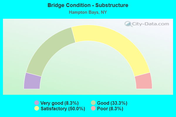
- Bridge Condition - Substructure
- 8.3%Very good
- 33.3%Good
- 50.0%Satisfactory
- 8.3%Poor
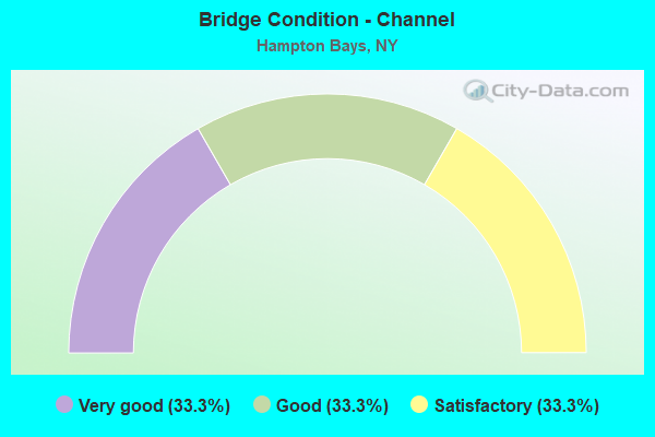
- Bridge Condition - Channel
- 33.3%Very good
- 33.3%Good
- 33.3%Satisfactory
Find on map >> Show street view
Structure Number: 1019411, Location: 1 MI E EXIT 65 OF S.H.27 (Lat: 40.885378, Lng: -72.524914), Route carried "on" structure: State highway 27, Year Built: 1963, Status: Open, Structure Length: 6.61m (21.69ft), Average Daily Traffic: 18,389 (year 2019), Truck Traffic: 6%, Average Future Daily Traffic: 21,873 (year 2040), Design Load: HS 20, Features Intersected: SQUIRETOWN RD NB, SQUIRE
Minimum Vertical Clearance: 30+ m (98+ ft), Kilometerpoint: 80.498, Lanes on structure: 2, Lanes under structure: 4, Base Highway Network: Yes, Owner: State Highway Agency, Approaching Roadway Width: 12.5m (41.0ft), Skew: 4 degrees, Material/Design: Steel, Design/Construction: Stringer/Multi-beam, Number Of Spans In Main Unit: 4, Length of Maximum Span: 17.4m (57.1ft), Curb-To-Curb Width: 12.6m (41.3ft), Out-to-Out Width: 14.2m (46.6ft)
Condition: Deck: Good, Superstructure: Good, Substructure: Satisfactory, Operating Rating: 64.4 metric tons, Method Used To Determine Operating Rating: Load Factor (LF), Inventory Rating: 38.1 metric tons, Method Used To Determine Inventory Rating: Load Factor (LF), Structural Evaluation: Equal to present minimum criteria, Deck Geometry: Better than present minimum criteria, Underclear: Meets minimum limits, Approach Roadway Alignment: Equal to present desirable criteria, Length Of Structure Improvement: 6.61m (21.69ft), Designated Inspection Frequency: Every 24 months, Inspection Date: April 2020, Bridge Improvement Cost: $3,638,000, Roadway Improvement Cost: $2,130,000, Total Project Cost: $5,768,000 ( Estimate for 2021), Deck Structure Type: Concrete Cast-file-Place, Wearing Surface/Protective System: Wearing Surface: Integral Concrete
Find on map >> Show street view
Structure Number: 1019412, Location: 1 MI E EXIT 60 OF SH 27 (Lat: 40.885017, Lng: -72.525064), Route carried "on" structure: State highway 27, Year Built: 1963, Status: Open, Structure Length: 6.40m (21.00ft), Average Daily Traffic: 18,389 (year 2019), Truck Traffic: 6%, Average Future Daily Traffic: 21,873 (year 2040), Design Load: HS 20, Features Intersected: SQUIRETOWN RD NB, SQUIRE
Minimum Vertical Clearance: 30+ m (98+ ft), Kilometerpoint: 80.498, Lanes on structure: 2, Lanes under structure: 4, Base Highway Network: Yes, Owner: State Highway Agency, Approaching Roadway Width: 12.5m (41.0ft), Skew: 4 degrees, Material/Design: Steel, Design/Construction: Stringer/Multi-beam, Number Of Spans In Main Unit: 4, Length of Maximum Span: 17.4m (57.1ft), Curb-To-Curb Width: 12.6m (41.3ft), Out-to-Out Width: 14.2m (46.6ft)
Condition: Deck: Satisfactory, Superstructure: Good, Substructure: Satisfactory, Operating Rating: 65.3 metric tons, Method Used To Determine Operating Rating: Load Factor (LF), Inventory Rating: 39.0 metric tons, Method Used To Determine Inventory Rating: Load Factor (LF), Structural Evaluation: Equal to present minimum criteria, Deck Geometry: Better than present minimum criteria, Underclear: Meets minimum limits, Approach Roadway Alignment: Equal to present desirable criteria, Length Of Structure Improvement: 6.40m (21.00ft), Designated Inspection Frequency: Every 24 months, Inspection Date: April 2020, Bridge Improvement Cost: $3,526,000, Roadway Improvement Cost: $2,065,000, Total Project Cost: $5,591,000 ( Estimate for 2021), Deck Structure Type: Concrete Cast-file-Place, Wearing Surface/Protective System: Wearing Surface: Integral Concrete
Find on map >> Show street view
Structure Number: 1019429, Location: 1.8 MI E SH 24 & SH 27 (Lat: 40.889656, Lng: -72.504178), Route carried "on" structure: State highway 27, Year Built: 1963, Status: Open, Structure Length: 3.75m (12.30ft), Average Daily Traffic: 36,778 (year 2019), Truck Traffic: 6%, Average Future Daily Traffic: 43,747 (year 2040), Design Load: HS 20, Features Intersected: NEWTOWN ROAD
Minimum Vertical Clearance: 30+ m (98+ ft), Kilometerpoint: 82.349, Lanes on structure: 4, Lanes under structure: 2, Base Highway Network: Yes, Owner: State Highway Agency, Approaching Roadway Width: 25.0m (82.0ft), Skew: 20 degrees, Material/Design: Steel, Design/Construction: Stringer/Multi-beam, Number Of Spans In Main Unit: 3, Length of Maximum Span: 16.1m (52.8ft), Curb-To-Curb Width: 24.9m (81.7ft), Out-to-Out Width: 27.7m (90.9ft)
Condition: Deck: Satisfactory, Superstructure: Good, Substructure: Satisfactory, Operating Rating: 55.3 metric tons, Method Used To Determine Operating Rating: Load Factor (LF), Inventory Rating: 32.7 metric tons, Method Used To Determine Inventory Rating: Load Factor (LF), Structural Evaluation: Equal to present minimum criteria, Deck Geometry: Superior to present desirable criteria, Underclear: Equal to present minimum criteria, Approach Roadway Alignment: Equal to present desirable criteria, Length Of Structure Improvement: 3.74m (12.27ft), Designated Inspection Frequency: Every 24 months, Inspection Date: July 2020, Bridge Improvement Cost: $4,141,000, Roadway Improvement Cost: $2,425,000, Total Project Cost: $6,567,000 ( Estimate for 2021), Deck Structure Type: Concrete Cast-file-Place, Wearing Surface/Protective System: Wearing Surface: Monolithic Concrete
Find on map >> Show street view
Structure Number: 1019439, Location: 2 MI E JCT SH 24 & SH 27 (Lat: 40.890033, Lng: -72.500978), Route carried "on" structure: State highway 27, Year Built: 1960, Year Reconstructed: 1999, Status: Open, Structure Length: 11.25m (36.91ft), Average Daily Traffic: 36,778 (year 2019), Truck Traffic: 6%, Average Future Daily Traffic: 43,747 (year 2040), Design Load: HS 20+Mod, Features Intersected: CANAL ROAD EAST, SHINNEC
Minimum Vertical Clearance: 30+ m (98+ ft), Kilometerpoint: 82.542, Lanes on structure: 4, Lanes under structure: 2, Base Highway Network: Yes, Owner: State Highway Agency, Approaching Roadway Width: 25.0m (82.0ft), Skew: 20 degrees, Navigation Control: Yes ( Vertical Clearance: 7.0m (23.0ft), Horizontal Clearance: 45.1m (148.0ft)), Material/Design: Steel, Design/Construction: Stringer/Multi-beam, Number Of Spans In Main Unit: 3, Length of Maximum Span: 49.9m (163.7ft), Curb-To-Curb Width: 25.0m (82.0ft), Out-to-Out Width: 27.7m (90.9ft)
Condition: Deck: Satisfactory, Superstructure: Good, Substructure: Good, Channel: Very good, Operating Rating: 71.7 metric tons, Method Used To Determine Operating Rating: Load Factor (LF), Inventory Rating: 45.4 metric tons, Method Used To Determine Inventory Rating: Load Factor (LF), Structural Evaluation: Better than present minimum criteria, Deck Geometry: Superior to present desirable criteria, Underclear: Meets minimum limits, Waterway Adequacy: Equal to present minimum criteria, Approach Roadway Alignment: Equal to present desirable criteria, Length Of Structure Improvement: 11.24m (36.88ft), Designated Inspection Frequency: Every 24 months, Underwater Inspection Frequency: Every 60 months, Inspection Date: October 2021, Underwater Inspection Date: July 2018, Bridge Improvement Cost: $11,404,000, Roadway Improvement Cost: $6,678,000, Total Project Cost: $18,083,000 ( Estimate for 2021), Deck Structure Type: Concrete Cast-file-Place, Wearing Surface/Protective System: Wearing Surface: Integral Concrete, Deck Protection: Epoxy Coated Reinforcing
Find on map >> Show street view
Structure Number: 1019449, Location: SH 27 - 3.3MI W OF TUCKAH (Lat: 40.890392, Lng: -72.498128), Route carried "on" structure: State highway 27, Year Built: 1959, Status: Open, Structure Length: 6.37m (20.90ft), Average Daily Traffic: 36,778 (year 2019), Truck Traffic: 6%, Average Future Daily Traffic: 43,747 (year 2040), Design Load: HS 20, Features Intersected: CR 39 - NORTH RD
Minimum Vertical Clearance: 30+ m (98+ ft), Kilometerpoint: 82.847, Lanes on structure: 4, Lanes under structure: 2, Base Highway Network: Yes, Owner: State Highway Agency, Approaching Roadway Width: 25.0m (82.0ft), Skew: 25 degrees, Material/Design: Steel, Design/Construction: Stringer/Multi-beam, Number Of Spans In Main Unit: 3, Length of Maximum Span: 29.5m (96.8ft), Curb-To-Curb Width: 24.9m (81.7ft), Out-to-Out Width: 27.7m (90.9ft)
Condition: Deck: Good, Superstructure: Satisfactory, Substructure: Poor, Operating Rating: 89.8 metric tons, Method Used To Determine Operating Rating: Load Factor (LF), Inventory Rating: 33.6 metric tons, Method Used To Determine Inventory Rating: Load Factor (LF), Structural Evaluation: Meets minimum limits, Deck Geometry: Superior to present desirable criteria, Underclear: High priority of corrective action, Approach Roadway Alignment: Equal to present desirable criteria, Length Of Structure Improvement: 6.37m (20.90ft), Designated Inspection Frequency: Every 24 months, Inspection Date: July 2021, Bridge Improvement Cost: $7,432,000, Roadway Improvement Cost: $4,352,000, Total Project Cost: $11,784,000 ( Estimate for 2021), Deck Structure Type: Concrete Cast-file-Place, Wearing Surface/Protective System: Wearing Surface: Monolithic Concrete
Find on map >> Show street view
Structure Number: 1056381, Location: .7 MI W JCT SH 24 & SH 27 (Lat: 40.876486, Lng: -72.550636), Route carried "on" structure: State highway 27, Year Built: 1973, Status: Open, Structure Length: 2.90m (9.51ft), Average Daily Traffic: 16,312 (year 2019), Truck Traffic: 6%, Average Future Daily Traffic: 19,403 (year 2040), Design Load: HS 20, Features Intersected: BELLOWS POND ROAD
Minimum Vertical Clearance: 30+ m (98+ ft), Kilometerpoint: 78.133, Lanes on structure: 2, Lanes under structure: 2, Base Highway Network: Yes, Owner: State Highway Agency, Approaching Roadway Width: 12.5m (41.0ft), Skew: 2 degrees, Material/Design: Steel, Design/Construction: Stringer/Multi-beam, Number Of Spans In Main Unit: 1, Length of Maximum Span: 27.4m (89.9ft), Curb-To-Curb Width: 12.5m (41.0ft), Out-to-Out Width: 13.4m (44.0ft)
Condition: Deck: Very good, Superstructure: Good, Substructure: Good, Operating Rating: 62.6 metric tons, Method Used To Determine Operating Rating: Load Factor (LF), Inventory Rating: 35.4 metric tons, Method Used To Determine Inventory Rating: Load Factor (LF), Structural Evaluation: Better than present minimum criteria, Deck Geometry: Better than present minimum criteria, Underclear: Equal to present minimum criteria, Approach Roadway Alignment: Equal to present desirable criteria, Length Of Structure Improvement: 2.89m (9.48ft), Designated Inspection Frequency: Every 24 months, Inspection Date: July 2021, Bridge Improvement Cost: $2,776,000, Roadway Improvement Cost: $1,626,000, Total Project Cost: $4,401,000 ( Estimate for 2021), Deck Structure Type: Concrete Cast-file-Place, Wearing Surface/Protective System: Wearing Surface: Integral Concrete
Find on map >> Show street view
Structure Number: 1056382, Location: .7 MI W JCT SH 24 & SH 27 (Lat: 40.876200, Lng: -72.550500), Route carried "on" structure: State highway 27, Year Built: 1973, Status: Open, Structure Length: 2.90m (9.51ft), Average Daily Traffic: 16,312 (year 2019), Truck Traffic: 6%, Average Future Daily Traffic: 19,403 (year 2040), Design Load: HS 20, Features Intersected: BELLOWS POND ROAD
Minimum Vertical Clearance: 30+ m (98+ ft), Kilometerpoint: 78.133, Lanes on structure: 2, Lanes under structure: 2, Base Highway Network: Yes, Owner: State Highway Agency, Approaching Roadway Width: 12.5m (41.0ft), Skew: 2 degrees, Material/Design: Steel, Design/Construction: Stringer/Multi-beam, Number Of Spans In Main Unit: 1, Length of Maximum Span: 27.4m (89.9ft), Curb-To-Curb Width: 12.5m (41.0ft), Out-to-Out Width: 13.4m (44.0ft)
Condition: Deck: Good, Superstructure: Good, Substructure: Very good, Operating Rating: 62.6 metric tons, Method Used To Determine Operating Rating: Load Factor (LF), Inventory Rating: 35.4 metric tons, Method Used To Determine Inventory Rating: Load Factor (LF), Structural Evaluation: Better than present minimum criteria, Deck Geometry: Better than present minimum criteria, Underclear: Equal to present minimum criteria, Approach Roadway Alignment: Equal to present desirable criteria, Length Of Structure Improvement: 2.89m (9.48ft), Designated Inspection Frequency: Every 24 months, Inspection Date: July 2021, Bridge Improvement Cost: $2,776,000, Roadway Improvement Cost: $1,626,000, Total Project Cost: $4,401,000 ( Estimate for 2021), Deck Structure Type: Concrete Cast-file-Place, Wearing Surface/Protective System: Wearing Surface: Integral Concrete
Find on map >> Show street view
Structure Number: 1056391, Location: RTE 24+RTE 27 (Lat: 40.879856, Lng: -72.536819), Route carried "on" structure: State highway 27, Year Built: 1973, Status: Open, Structure Length: 4.39m (14.40ft), Average Daily Traffic: 18,389 (year 2019), Truck Traffic: 6%, Average Future Daily Traffic: 21,873 (year 2040), Design Load: HS 20, Features Intersected: 24 24 07042076, RTE 24
Minimum Vertical Clearance: 30+ m (98+ ft), Kilometerpoint: 79.356, Lanes on structure: 3, Lanes under structure: 6, Base Highway Network: Yes, Owner: State Highway Agency, Approaching Roadway Width: 15.5m (50.9ft), Skew: 1 degrees, Material/Design: Steel, Design/Construction: Stringer/Multi-beam, Number Of Spans In Main Unit: 1, Length of Maximum Span: 42.3m (138.8ft), Curb-To-Curb Width: 15.5m (50.9ft), Out-to-Out Width: 16.5m (54.1ft)
Condition: Deck: Good, Superstructure: Satisfactory, Substructure: Satisfactory, Operating Rating: 72.6 metric tons, Method Used To Determine Operating Rating: Load Factor (LF), Inventory Rating: 38.1 metric tons, Method Used To Determine Inventory Rating: Load Factor (LF), Structural Evaluation: Equal to present minimum criteria, Deck Geometry: Somewhat better than minimum adequacy, Underclear: Equal to present minimum criteria, Approach Roadway Alignment: Equal to present desirable criteria, Length Of Structure Improvement: 4.38m (14.37ft), Designated Inspection Frequency: Every 24 months, Inspection Date: September 2021, Bridge Improvement Cost: $4,064,000, Roadway Improvement Cost: $2,380,000, Total Project Cost: $6,444,000 ( Estimate for 2021), Deck Structure Type: Concrete Cast-file-Place, Wearing Surface/Protective System: Wearing Surface: Integral Concrete
Find on map >> Show street view
Structure Number: 1056392, Location: RTE 24+RTE 27 (Lat: 40.879564, Lng: -72.536708), Route carried "on" structure: State highway 27, Year Built: 1973, Status: Open, Structure Length: 4.39m (14.40ft), Average Daily Traffic: 18,389 (year 2019), Truck Traffic: 6%, Average Future Daily Traffic: 21,873 (year 2040), Design Load: HS 20, Features Intersected: 24 24 07042076, RTE 24
Minimum Vertical Clearance: 30+ m (98+ ft), Kilometerpoint: 79.324, Lanes on structure: 3, Lanes under structure: 6, Base Highway Network: Yes, Owner: State Highway Agency, Approaching Roadway Width: 15.5m (50.9ft), Skew: 1 degrees, Material/Design: Steel, Design/Construction: Stringer/Multi-beam, Number Of Spans In Main Unit: 1, Length of Maximum Span: 42.3m (138.8ft), Curb-To-Curb Width: 15.5m (50.9ft), Out-to-Out Width: 16.5m (54.1ft)
Condition: Deck: Good, Superstructure: Satisfactory, Substructure: Good, Operating Rating: 72.6 metric tons, Method Used To Determine Operating Rating: Load Factor (LF), Inventory Rating: 38.1 metric tons, Method Used To Determine Inventory Rating: Load Factor (LF), Structural Evaluation: Equal to present minimum criteria, Deck Geometry: Somewhat better than minimum adequacy, Underclear: Equal to present minimum criteria, Approach Roadway Alignment: Equal to present desirable criteria, Length Of Structure Improvement: 4.38m (14.37ft), Designated Inspection Frequency: Every 24 months, Inspection Date: September 2021, Bridge Improvement Cost: $4,028,000, Roadway Improvement Cost: $2,359,000, Total Project Cost: $6,387,000 ( Estimate for 2021), Deck Structure Type: Concrete Cast-file-Place, Wearing Surface/Protective System: Wearing Surface: Integral Concrete
Find on map >> Show street view
Structure Number: 301956, Location: .1 MI E JCT RT 24&MTK HWY (Lat: 40.881406, Lng: -72.512258), Route carried "on" structure: Other road , Year Built: 1934, Status: Posted for load-capacity, Structure Length: 10.12m (33.20ft), Average Daily Traffic: 13,629 (year 2018), Truck Traffic: 6%, Average Future Daily Traffic: 16,556 (year 2040), Design Load: H 20, Features Intersected: LIRR-MONTAUK BRCH, Facility Carried by Structure: MONTAUK HIGHWAY
Minimum Vertical Clearance: 30+ m (98+ ft), Kilometerpoint: 48.833, Lanes on structure: 2, Owner: County Highway Agency, Approaching Roadway Width: 12.2m (40.0ft), Skew: 20 degrees, Material/Design: Steel, Design/Construction: Girder and Floorbeam System, Number Of Spans In Main Unit: 5, Length of Maximum Span: 28.0m (91.9ft), Curb or Sidewalk Widths: Left: 0.0m, Right: 1.2m (3.9ft), Curb-To-Curb Width: 12.2m (40.0ft), Out-to-Out Width: 15.2m (49.9ft)
Condition: Deck: Satisfactory, Superstructure: Fair, Substructure: Satisfactory, Operating Rating: 27.6 metric tons, Method Used To Determine Operating Rating: Load Factor (LF), Inventory Rating: 16.5 metric tons, Method Used To Determine Inventory Rating: Load Factor (LF), Structural Evaluation: Meets minimum limits, Deck Geometry: Somewhat better than minimum adequacy, Underclear: High priority of corrective action, Approach Roadway Alignment: Better than present minimum criteria, Length Of Structure Improvement: 10.11m (33.17ft), Designated Inspection Frequency: Every 24 months, Critical Feature Inspection Frequency: Every 24 months, Inspection Date: August 2020, Critical Feature Inspection Date: August 2020, Bridge Improvement Cost: $6,123,000, Roadway Improvement Cost: $3,585,000, Total Project Cost: $9,708,000 ( Estimate for 2021), Deck Structure Type: Concrete Cast-file-Place, Wearing Surface/Protective System: Wearing Surface: Bituminous
Find on map >> Show street view
Structure Number: 301957, Location: .7 MI E JCT RT 24&MTK HWY (Lat: 40.884978, Lng: -72.500783), Route carried "on" structure: Other road , Year Built: 1970, Status: Open, Structure Length: 10.18m (33.40ft), Average Daily Traffic: 20,175 (year 2020), Truck Traffic: 7%, Average Future Daily Traffic: 24,508 (year 2040), Features Intersected: SHINNECOCK CANAL, Facility Carried by Structure: MONTAUK HWY
Minimum Vertical Clearance: 30+ m (98+ ft), Kilometerpoint: 49.863, Lanes on structure: 2, Owner: County Highway Agency, Approaching Roadway Width: 16.5m (54.1ft), Skew: 20 degrees, Navigation Control: Yes ( Vertical Clearance: 7.6m (24.9ft), Horizontal Clearance: 34.4m (112.9ft)), Material/Design: Steel continuous, Design/Construction: Stringer/Multi-beam, Number Of Spans In Main Unit: 3, Length of Maximum Span: 42.6m (139.8ft), Curb or Sidewalk Widths: Left: 1.6m (5.2ft), Right: 1.6m (5.2ft), Curb-To-Curb Width: 16.5m (54.1ft), Out-to-Out Width: 20.3m (66.6ft)
Condition: Deck: Satisfactory, Superstructure: Satisfactory, Substructure: Satisfactory, Channel: Satisfactory, Operating Rating: 40.2 metric tons, Method Used To Determine Operating Rating: Load and Resistance Factor Rating (LRFR) rating reported by rating factor(RF) method using HL-93 loadings, Inventory Rating: 30.8 metric tons, Method Used To Determine Inventory Rating: Load and Resistance Factor Rating (LRFR) rating reported by rating factor(RF) method using HL-93 loadings, Structural Evaluation: Equal to present minimum criteria, Deck Geometry: Superior to present desirable criteria, Waterway Adequacy: Equal to present desirable criteria, Approach Roadway Alignment: Superior to present desirable criteria, Length Of Structure Improvement: 10.18m (33.40ft), Designated Inspection Frequency: Every 24 months, Underwater Inspection Frequency: Every 60 months, Inspection Date: March 2020, Underwater Inspection Date: July 2018, Bridge Improvement Cost: $8,186,000, Roadway Improvement Cost: $4,794,000, Total Project Cost: $12,979,000 ( Estimate for 2021), Deck Structure Type: Concrete Cast-file-Place, Wearing Surface/Protective System: Wearing Surface: Bituminous
Find on map >> Show street view
Structure Number: 330052, Location: SOUTH OF PONQUOGUE-BEACH (Lat: 40.841353, Lng: -72.499300), Route carried "on" structure: County highway , Year Built: 1988, Status: Posted for load-capacity, Structure Length: 85.07m (279.10ft), Average Daily Traffic: 5,151 (year 2020), Truck Traffic: 3%, Average Future Daily Traffic: 6,257 (year 2040), Design Load: HS 20, Features Intersected: SHINNECOCK BAY, Facility Carried by Structure: PONQUOGUE AV-CR32
Minimum Vertical Clearance: 30+ m (98+ ft), Kilometerpoint: 0.322, Lanes on structure: 2, Owner: County Highway Agency, Approaching Roadway Width: 9.1m (29.9ft), Navigation Control: Yes ( Vertical Clearance: 16.7m (54.8ft), Horizontal Clearance: 30.4m (99.7ft)), Material/Design: Prestressed concrete continuous, Design/Construction: Stringer/Multi-beam, Number Of Spans In Main Unit: 27, Length of Maximum Span: 45.7m (149.9ft), Curb or Sidewalk Widths: Left: 0.0m, Right: 1.8m (5.9ft), Curb-To-Curb Width: 9.1m (29.9ft), Out-to-Out Width: 11.8m (38.7ft)
Condition: Deck: Good, Superstructure: Satisfactory, Substructure: Good, Channel: Good, Operating Rating: 49.0 metric tons, Method Used To Determine Operating Rating: Load Factor (LF), Inventory Rating: 32.7 metric tons, Method Used To Determine Inventory Rating: Load Factor (LF), Structural Evaluation: Equal to present minimum criteria, Deck Geometry: Meets minimum limits, Waterway Adequacy: Equal to present minimum criteria, Approach Roadway Alignment: Equal to present desirable criteria, Length Of Structure Improvement: 85.06m (279.07ft), Designated Inspection Frequency: Every 24 months, Underwater Inspection Frequency: Every 60 months, Inspection Date: October 2020, Underwater Inspection Date: August 2019, Bridge Improvement Cost: $26,062,000, Roadway Improvement Cost: $15,262,000, Total Project Cost: $41,324,000 ( Estimate for 2021), Deck Structure Type: Concrete Cast-file-Place, Wearing Surface/Protective System: Wearing Surface: Integral Concrete, Deck Protection: Epoxy Coated Reinforcing
Find on map >> Show street view
Structure Number: 1019411, Location: 1 MI E EXIT 65 OF S.H.27 (Lat: 40.885378, Lng: -72.524914), Route carried "under" structure: Other road , Year Built: 1963, Structure Length: 0. m, Average Daily Traffic: 11,949 (year 2003), Features Intersected: SQUIRETOWN RD NB, SQUIRE, Facility Carried by Structure: RTE 27
Minimum Vertical Clearance: 5.16m (16.93ft), Kilometerpoint: 0.000, Lanes on structure: 2, Lanes under structure: 2, Material/Design: Steel, Design/Construction: Stringer/Multi-beam, Length of Maximum Span: 17.4m (57.1ft)
Find on map >> Show street view
Structure Number: 1019412, Location: 1 MI E EXIT 60 OF SH 27 (Lat: 40.885017, Lng: -72.525064), Route carried "under" structure: Other road , Year Built: 1963, Structure Length: 0. m, Average Daily Traffic: 11,989 (year 2003), Features Intersected: SQUIRETOWN RD NB, SQUIRE, Facility Carried by Structure: RTE 27
Minimum Vertical Clearance: 4.32m (14.17ft), Kilometerpoint: 0.000, Lanes on structure: 2, Lanes under structure: 2, Material/Design: Steel, Design/Construction: Stringer/Multi-beam, Length of Maximum Span: 17.4m (57.1ft)
Find on map >> Show street view
Structure Number: 1019429, Location: 1.8 MI E SH 24 & SH 27 (Lat: 40.889656, Lng: -72.504178), Route carried "under" structure: Other road , Year Built: 1963, Structure Length: 0. m, Average Daily Traffic: 7,100 (year 1972), Features Intersected: NEWTOWN ROAD, Facility Carried by Structure: RTE 27
Minimum Vertical Clearance: 4.74m (15.55ft), Kilometerpoint: 0.000, Lanes on structure: 4, Lanes under structure: 2, Material/Design: Steel, Design/Construction: Stringer/Multi-beam, Length of Maximum Span: 16.1m (52.8ft)
Find on map >> Show street view
Structure Number: 1019439, Location: 2 MI E JCT SH 24 & SH 27 (Lat: 40.890033, Lng: -72.500978), Route carried "under" structure: Other road , Year Built: 1960, Structure Length: 0. m, Average Daily Traffic: 300 (year 2021), Features Intersected: CANAL ROAD EAST, SHINNEC, Facility Carried by Structure: RTE 27
Minimum Vertical Clearance: 6.88m (22.57ft), Kilometerpoint: 0.000, Lanes on structure: 4, Lanes under structure: 2, Material/Design: Steel, Design/Construction: Stringer/Multi-beam, Length of Maximum Span: 49.9m (163.7ft)
Find on map >> Show street view
Structure Number: 1019449, Location: SH 27 - 3.3MI W OF TUCKAH (Lat: 40.890392, Lng: -72.498128), Route carried "under" structure: County highway , Year Built: 1959, Structure Length: 0. m, Average Daily Traffic: 10,618 (year 2005), Features Intersected: CR 39 - NORTH RD, Facility Carried by Structure: RTE 27
Minimum Vertical Clearance: 4.45m (14.60ft), Kilometerpoint: 0.000, Lanes on structure: 4, Lanes under structure: 2, Material/Design: Steel, Design/Construction: Stringer/Multi-beam, Length of Maximum Span: 29.5m (96.8ft)
Find on map >> Show street view
Structure Number: 1056381, Location: .7 MI W JCT SH 24 & SH 27 (Lat: 40.876486, Lng: -72.550636), Route carried "under" structure: Other road , Year Built: 1973, Structure Length: 0. m, Average Daily Traffic: 1,000 (year 2021), Features Intersected: BELLOWS POND ROAD, Facility Carried by Structure: RTE 27
Minimum Vertical Clearance: 4.52m (14.83ft), Kilometerpoint: 0.000, Lanes on structure: 2, Lanes under structure: 2, Material/Design: Steel, Design/Construction: Stringer/Multi-beam, Length of Maximum Span: 27.4m (89.9ft)
Find on map >> Show street view
Structure Number: 1056382, Location: .7 MI W JCT SH 24 & SH 27 (Lat: 40.876200, Lng: -72.550500), Route carried "under" structure: Other road , Year Built: 1973, Structure Length: 0. m, Average Daily Traffic: 1,000 (year 2021), Features Intersected: BELLOWS POND ROAD, Facility Carried by Structure: RTE 27
Minimum Vertical Clearance: 4.92m (16.14ft), Kilometerpoint: 0.000, Lanes on structure: 2, Lanes under structure: 2, Material/Design: Steel, Design/Construction: Stringer/Multi-beam, Length of Maximum Span: 27.4m (89.9ft)
Find on map >> Show street view
Structure Number: 1056391, Location: RTE 24+RTE 27 (Lat: 40.879856, Lng: -72.536819), Route carried "under" structure: State highway 24, Year Built: 1973, Structure Length: 0. m, Average Daily Traffic: 7,650 (year 1973), Features Intersected: 24 24 07042076, RTE 24, Facility Carried by Structure: RTE 27
Minimum Vertical Clearance: 5.23m (17.16ft), Kilometerpoint: 12.051, Lanes on structure: 3, Lanes under structure: 3, Material/Design: Steel, Design/Construction: Stringer/Multi-beam, Length of Maximum Span: 42.3m (138.8ft)
Find on map >> Show street view
Structure Number: 1056392, Location: RTE 24+RTE 27 (Lat: 40.879564, Lng: -72.536708), Route carried "under" structure: State highway 24, Year Built: 1973, Structure Length: 0. m, Average Daily Traffic: 7,650 (year 1973), Features Intersected: 24 24 07042076, RTE 24, Facility Carried by Structure: RTE 27
Minimum Vertical Clearance: 4.78m (15.68ft), Kilometerpoint: 12.051, Lanes on structure: 3, Lanes under structure: 3, Material/Design: Steel, Design/Construction: Stringer/Multi-beam, Length of Maximum Span: 42.3m (138.8ft)
Find on map >> Show street view
Structure Number: 705646, Location: 24.4 MI NE RTS 112+27A (Lat: 40.869572, Lng: -72.545200), Route carried "under" structure: Other road , Year Built: 1930, Structure Length: 0. m, Average Daily Traffic: 11,800 (year 1980), Features Intersected: MONTAUK HWY=CR 80, Facility Carried by Structure: LIRR WEST TIANA
Minimum Vertical Clearance: 4.19m (13.75ft), Kilometerpoint: 0.000, Lanes under structure: 2, Material/Design: Steel, Design/Construction: Girder and Floorbeam System, Length of Maximum Span: 27.1m (88.9ft)
Find on map >> Show street view
Structure Number: 771016, Location: 1.2 MI E OF HAMPTON BAYS (Lat: 40.887250, Lng: -72.501533), Route carried "under" structure: County highway , Year Built: 1917, Structure Length: 0. m, Average Daily Traffic: 2,500 (year 2021), Features Intersected: PECONIC AVE, Facility Carried by Structure: LIRR MONTAUK BR
Minimum Vertical Clearance: 3.86m (12.66ft), Kilometerpoint: 0.000, Lanes under structure: 2, Material/Design: Steel, Design/Construction: Stringer/Multi-beam, Length of Maximum Span: 8.8m (28.9ft)
Find on map >> Show street view
Structure Number: 771018, Location: 1.4 MI E OF HAMPTON BAYS (Lat: 40.888131, Lng: -72.500014), Route carried "under" structure: County highway , Year Built: 1907, Structure Length: 0. m, Average Daily Traffic: 2,100 (year 1978), Features Intersected: NORTH HIGHWAY, Facility Carried by Structure: LIRR MONTAUK BR
Minimum Vertical Clearance: 3.88m (12.73ft), Kilometerpoint: 0.000, Lanes under structure: 2, Material/Design: Steel, Design/Construction: Girder and Floorbeam System, Length of Maximum Span: 15.2m (49.9ft)