Bridge Statistics for Hastings, Minnesota (MN)
Condition, Traffic, Stress, Structural Evaluation, Project Costs
- National Bridge Inventory (NBI) Statistics
- 24Number of bridges
- 394ft / 120mTotal length
- $742,004,000Total costs
- 178,989Total average daily traffic
- 8,978Total average daily truck traffic
- National Bridge Inventory (NBI) Registered Bridges for Hastings
- No street view available for this location
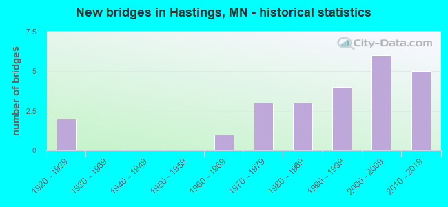
- New bridges - historical statistics
- 21920-1929
- 11960-1969
- 31970-1979
- 31980-1989
- 41990-1999
- 62000-2009
- 52010-2019
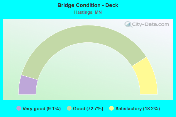
- Bridge Condition - Deck
- 9.1%Very good
- 72.7%Good
- 18.2%Satisfactory
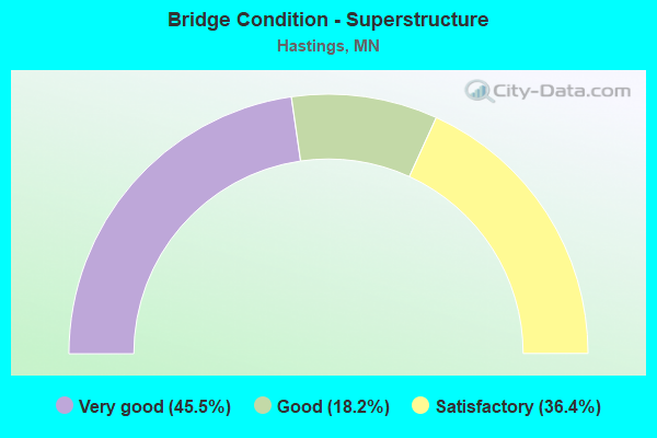
- Bridge Condition - Superstructure
- 45.5%Very good
- 18.2%Good
- 36.4%Satisfactory
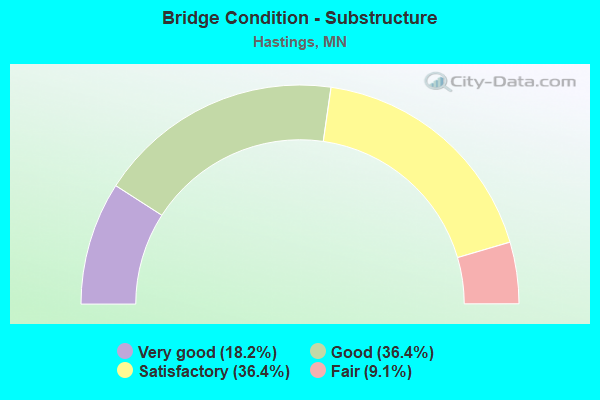
- Bridge Condition - Substructure
- 18.2%Very good
- 36.4%Good
- 36.4%Satisfactory
- 9.1%Fair
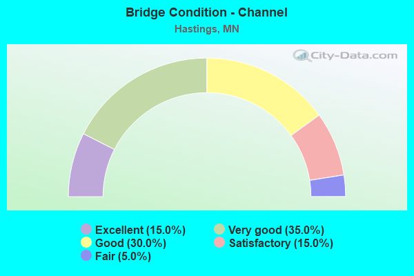
- Bridge Condition - Channel
- 15.0%Excellent
- 35.0%Very good
- 30.0%Good
- 15.0%Satisfactory
- 5.0%Fair
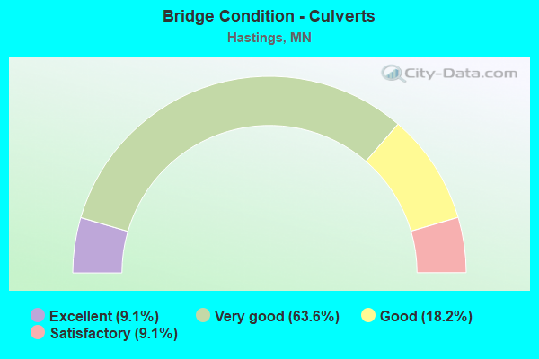
- Bridge Condition - Culverts
- 9.1%Excellent
- 63.6%Very good
- 18.2%Good
- 9.1%Satisfactory
Find on map >> Show street view
Structure Number: 19004, Location: 0.8 MI N OF JCT TH 55 (Lat: 44.746833, Lng: -92.853111), Route carried "on" structure: US 61, Year Built: 2013, Status: Open, Structure Length: 59.24m (194.36ft), Average Daily Traffic: 32,000 (year 2019), Truck Traffic: 5%, Average Future Daily Traffic: 31,000 (year 2039), Design Load: HL 93, Features Intersected: MISS R;2ND ST;N LOOP RD
Minimum Vertical Clearance: 30+ m (98+ ft), Kilometerpoint: 0.000, Lanes on structure: 4, Lanes under structure: 4, Base Highway Network: Yes, Owner: State Highway Agency, Approaching Roadway Width: 21.9m (71.9ft), Skew: 30 degrees, Navigation Control: Yes ( Vertical Clearance: 19.8m (65.0ft), Horizontal Clearance: 140.1m (459.6ft)), Material/Design: Steel, Design/Construction: Arch - Thru, Number Of Spans In Main Unit: 1, Number Of Approach Spans: 10, Length of Maximum Span: 166.1m (544.9ft), Curb or Sidewalk Widths: Left: 0.0m, Right: 3.7m (12.1ft), Curb-To-Curb Width: 21.9m (71.9ft), Out-to-Out Width: 23.8m (78.1ft)
Condition: Deck: Good, Superstructure: Good, Substructure: Satisfactory, Channel: Satisfactory, Operating Rating: 48.6 metric tons, Method Used To Determine Operating Rating: Load and Resistance Factor Rating (LRFR) rating reported by rating factor(RF) method using HL-93 loadings, Inventory Rating: 37.9 metric tons, Method Used To Determine Inventory Rating: Load and Resistance Factor Rating (LRFR) rating reported by rating factor(RF) method using HL-93 loadings, Structural Evaluation: Equal to present minimum criteria, Deck Geometry: Superior to present desirable criteria, Underclear: Equal to present minimum criteria, Waterway Adequacy: Equal to present desirable criteria, Approach Roadway Alignment: Equal to present desirable criteria, Designated Inspection Frequency: Every 24 months, Underwater Inspection Frequency: Every 60 months, Inspection Date: October 2021, Underwater Inspection Date: July 2021, Deck Structure Type: Concrete Cast-file-Place, Wearing Surface/Protective System: Wearing Surface: Low Slump Concrete, Deck Protection: Epoxy Coated Reinforcing
Find on map >> Show street view
Structure Number: 1901, Location: 0.6 MI E OF JCT TH 61 (Lat: 44.727414, Lng: -92.840950), Route carried "on" structure: City street 145, Year Built: 1970, Status: Open, Structure Length: 8.29m (27.20ft), Average Daily Traffic: 1,050 (year 2017), Truck Traffic: 6%, Average Future Daily Traffic: 1,050 (year 2039), Design Load: HS 20, Features Intersected: VERMILLION RIVER
Minimum Vertical Clearance: 30+ m (98+ ft), Kilometerpoint: 0.000, Lanes on structure: 2, Owner: City or Municipal Highway Agency, Approaching Roadway Width: 13.4m (44.0ft), Material/Design: Steel continuous, Design/Construction: Stringer/Multi-beam, Number Of Spans In Main Unit: 3, Length of Maximum Span: 32.6m (107.0ft), Curb or Sidewalk Widths: Left: 1.8m (5.9ft), Right: 0.0m, Curb-To-Curb Width: 9.6m (31.5ft), Out-to-Out Width: 12.8m (42.0ft)
Condition: Deck: Satisfactory, Superstructure: Satisfactory, Substructure: Fair, Channel: Very good, Operating Rating: 61.7 metric tons, Method Used To Determine Operating Rating: Load Factor (LF), Inventory Rating: 36.9 metric tons, Method Used To Determine Inventory Rating: Load Factor (LF), Structural Evaluation: Somewhat better than minimum adequacy, Deck Geometry: Somewhat better than minimum adequacy, Waterway Adequacy: Equal to present desirable criteria, Approach Roadway Alignment: Equal to present desirable criteria, Designated Inspection Frequency: Every 24 months, Inspection Date: July 2021, Deck Structure Type: Concrete Cast-file-Place, Wearing Surface/Protective System: Wearing Surface: Low Slump Concrete
Find on map >> Show street view
Structure Number: 19075, Location: 0.8 MI S OF JCT TH 55 (Lat: 44.724414, Lng: -92.852347), Route carried "on" structure: US 61, Year Built: 1978, Status: Open, Structure Length: 3.27m (10.73ft), Average Daily Traffic: 27,500 (year 2019), Truck Traffic: 6%, Average Future Daily Traffic: 29,000 (year 2039), Design Load: HS 20, Features Intersected: VERMILLION RIVER
Minimum Vertical Clearance: 30+ m (98+ ft), Kilometerpoint: 0.000, Lanes on structure: 4, Base Highway Network: Yes, Owner: State Highway Agency, Approaching Roadway Width: 18.9m (62.0ft), Skew: 21 degrees, Material/Design: Steel continuous, Design/Construction: Stringer/Multi-beam, Number Of Spans In Main Unit: 3, Length of Maximum Span: 14.0m (45.9ft), Curb or Sidewalk Widths: Left: 1.8m (5.9ft), Right: 2.4m (7.9ft), Curb-To-Curb Width: 20.7m (67.9ft), Out-to-Out Width: 26.9m (88.3ft)
Condition: Deck: Satisfactory, Superstructure: Satisfactory, Substructure: Satisfactory, Channel: Satisfactory, Operating Rating: 74.1 metric tons, Method Used To Determine Operating Rating: Load Factor (LF), Inventory Rating: 44.4 metric tons, Method Used To Determine Inventory Rating: Load Factor (LF), Structural Evaluation: Equal to present minimum criteria, Deck Geometry: Superior to present desirable criteria, Waterway Adequacy: Superior to present desirable criteria, Approach Roadway Alignment: Equal to present desirable criteria, Designated Inspection Frequency: Every 24 months, Inspection Date: July 2020, Deck Structure Type: Concrete Cast-file-Place, Wearing Surface/Protective System: Wearing Surface: Latex Concrete, Deck Protection: Epoxy Coated Reinforcing
Find on map >> Show street view
Structure Number: 19503, Location: 0.7 MI SW OF JCT TH 61 (Lat: 44.719733, Lng: -92.865661), Route carried "on" structure: County highway 46, Year Built: 1968, Status: Posted for load, Structure Length: 4.60m (15.09ft), Average Daily Traffic: 10,200 (year 2016), Truck Traffic: 6%, Average Future Daily Traffic: 10,200 (year 2039), Design Load: H 20, Features Intersected: VERMILLION RIVER
Minimum Vertical Clearance: 30+ m (98+ ft), Kilometerpoint: 0.000, Lanes on structure: 2, Owner: County Highway Agency, Approaching Roadway Width: 11.0m (36.1ft), Material/Design: Steel continuous, Design/Construction: Stringer/Multi-beam, Number Of Spans In Main Unit: 3, Length of Maximum Span: 17.4m (57.1ft), Curb-To-Curb Width: 10.5m (34.4ft), Out-to-Out Width: 11.4m (37.4ft)
Condition: Deck: Good, Superstructure: Satisfactory, Substructure: Good, Channel: Good, Operating Rating: 35.6 metric tons, Method Used To Determine Operating Rating: Load Factor (LF), Inventory Rating: 21.2 metric tons, Method Used To Determine Inventory Rating: Load Factor (LF), Structural Evaluation: Somewhat better than minimum adequacy, Deck Geometry: Meets minimum limits, Waterway Adequacy: Equal to present desirable criteria, Approach Roadway Alignment: Equal to present desirable criteria, Bridge Posting: Required (Relationship of Operating Rating to Maximum Legal Load: 0.1 - 9.9% below), Length Of Structure Improvement: 1.55m (5.09ft), Designated Inspection Frequency: Every 24 months, Inspection Date: January 2022, Bridge Improvement Cost: $545,000,000, Roadway Improvement Cost: $43,000,000, Total Project Cost: $657,000,000, Deck Structure Type: Concrete Cast-file-Place, Wearing Surface/Protective System: Wearing Surface: Low Slump Concrete, Deck Protection: Other
Find on map >> Show street view
Structure Number: 19523, Location: 0.7 MI E OF JCT TH 61 (Lat: 44.733739, Lng: -92.837403), Route carried "on" structure: City street 133, Year Built: 1982, Status: Open, Structure Length: 5.47m (17.95ft), Average Daily Traffic: 5,200 (year 2015), Average Future Daily Traffic: 5,200 (year 2039), Design Load: HS 20, Features Intersected: VERMILLION RIVER
Minimum Vertical Clearance: 30+ m (98+ ft), Kilometerpoint: 0.000, Lanes on structure: 2, Owner: City or Municipal Highway Agency, Approaching Roadway Width: 12.2m (40.0ft), Skew: 2 degrees, Material/Design: Prestressed concrete, Design/Construction: Stringer/Multi-beam, Number Of Spans In Main Unit: 3, Length of Maximum Span: 17.8m (58.4ft), Curb or Sidewalk Widths: Left: 1.8m (5.9ft), Right: 0.0m, Curb-To-Curb Width: 12.2m (40.0ft), Out-to-Out Width: 14.9m (48.9ft)
Condition: Deck: Good, Superstructure: Very good, Substructure: Good, Channel: Good, Operating Rating: 57.5 metric tons, Method Used To Determine Operating Rating: Load Factor (LF), Inventory Rating: 34.5 metric tons, Method Used To Determine Inventory Rating: Load Factor (LF), Structural Evaluation: Better than present minimum criteria, Deck Geometry: Somewhat better than minimum adequacy, Waterway Adequacy: Superior to present desirable criteria, Approach Roadway Alignment: Equal to present desirable criteria, Designated Inspection Frequency: Every 24 months, Inspection Date: June 2020, Deck Structure Type: Concrete Cast-file-Place, Wearing Surface/Protective System: Wearing Surface: Monolithic Concrete, Deck Protection: Epoxy Coated Reinforcing
Find on map >> Show street view
Structure Number: 19525, Location: 1.2 MI E OF JCT TH 61 (Lat: 44.742214, Lng: -92.828933), Route carried "on" structure: City street 17, Year Built: 1987, Status: Open, Structure Length: 1.73m (5.68ft), Average Daily Traffic: 100 (year 1995), Average Future Daily Traffic: 100 (year 2029), Design Load: HS 20, Features Intersected: VERMILLION RIVER
Minimum Vertical Clearance: 30+ m (98+ ft), Kilometerpoint: 0.000, Lanes on structure: 2, Owner: City or Municipal Highway Agency, Approaching Roadway Width: 8.5m (27.9ft), Material/Design: Prestressed concrete, Design/Construction: Tee Beam, Number Of Spans In Main Unit: 1, Length of Maximum Span: 16.5m (54.1ft), Curb-To-Curb Width: 8.7m (28.5ft), Out-to-Out Width: 9.8m (32.2ft)
Condition: Deck: Good, Superstructure: Very good, Substructure: Good, Channel: Good, Operating Rating: 42.1 metric tons, Method Used To Determine Operating Rating: Load Factor (LF), Inventory Rating: 25.1 metric tons, Method Used To Determine Inventory Rating: Load Factor (LF), Structural Evaluation: Equal to present minimum criteria, Deck Geometry: Better than present minimum criteria, Waterway Adequacy: Equal to present desirable criteria, Approach Roadway Alignment: Equal to present desirable criteria, Designated Inspection Frequency: Every 24 months, Inspection Date: June 2020, Deck Structure Type: Concrete Cast-file-Place, Wearing Surface/Protective System: Wearing Surface: Bituminous
Find on map >> Show street view
Structure Number: 19552, Location: .09 MI N OF JCT CSAH 46 (Lat: 44.718231, Lng: -92.891936), Route carried "on" structure: City street 136, Year Built: 2003, Status: Open, Structure Length: 5.99m (19.65ft), Average Daily Traffic: 100 (year 2004), Average Future Daily Traffic: 100 (year 2029), Design Load: HS 25 or greater, Features Intersected: VERMILLION RIVER
Minimum Vertical Clearance: 30+ m (98+ ft), Kilometerpoint: 0.000, Lanes on structure: 2, Owner: City or Municipal Highway Agency, Approaching Roadway Width: 13.4m (44.0ft), Material/Design: Prestressed concrete, Design/Construction: Stringer/Multi-beam, Number Of Spans In Main Unit: 3, Length of Maximum Span: 22.7m (74.5ft), Curb or Sidewalk Widths: Left: 3.4m (11.2ft), Right: 1.8m (5.9ft), Curb-To-Curb Width: 12.5m (41.0ft), Out-to-Out Width: 18.4m (60.4ft)
Condition: Deck: Good, Superstructure: Very good, Substructure: Good, Channel: Fair, Operating Rating: 56.8 metric tons, Method Used To Determine Operating Rating: Load Factor (LF), Inventory Rating: 30.2 metric tons, Method Used To Determine Inventory Rating: Load Factor (LF), Structural Evaluation: Better than present minimum criteria, Deck Geometry: Superior to present desirable criteria, Waterway Adequacy: Superior to present desirable criteria, Approach Roadway Alignment: Equal to present desirable criteria, Length Of Structure Improvement: 2.01m (6.59ft), Designated Inspection Frequency: Every 24 months, Inspection Date: June 2020, Bridge Improvement Cost: $999,999,000, Roadway Improvement Cost: $1,000, Total Project Cost: $1,000, Deck Structure Type: Concrete Cast-file-Place, Wearing Surface/Protective System: Wearing Surface: Monolithic Concrete, Deck Protection: Epoxy Coated Reinforcing
Find on map >> Show street view
Structure Number: 19569, Location: 0.5 MI W OF JCT CSAH 47 (Lat: 44.716822, Lng: -92.895783), Route carried "on" structure: County highway 46, Year Built: 2015, Status: Open, Structure Length: 4.01m (13.16ft), Average Daily Traffic: 8,100 (year 2019), Truck Traffic: 6%, Average Future Daily Traffic: 7,900 (year 2039), Design Load: HL 93, Features Intersected: VERMILLION RIVER
Minimum Vertical Clearance: 30+ m (98+ ft), Kilometerpoint: 0.000, Lanes on structure: 2, Base Highway Network: Yes, Owner: County Highway Agency, Approaching Roadway Width: 12.2m (40.0ft), Material/Design: Concrete continuous, Design/Construction: Slab, Number Of Spans In Main Unit: 3, Length of Maximum Span: 15.2m (49.9ft), Curb-To-Curb Width: 12.2m (40.0ft), Out-to-Out Width: 13.2m (43.3ft)
Condition: Deck: Good, Superstructure: Very good, Substructure: Very good, Channel: Very good, Operating Rating: 56.4 metric tons, Method Used To Determine Operating Rating: Load and Resistance Factor Rating (LRFR) rating reported by rating factor(RF) method using HL-93 loadings, Inventory Rating: 43.4 metric tons, Method Used To Determine Inventory Rating: Load and Resistance Factor Rating (LRFR) rating reported by rating factor(RF) method using HL-93 loadings, Structural Evaluation: Equal to present desirable criteria, Deck Geometry: Somewhat better than minimum adequacy, Waterway Adequacy: Equal to present desirable criteria, Approach Roadway Alignment: Equal to present desirable criteria, Designated Inspection Frequency: Every 24 months, Inspection Date: January 2022, Deck Structure Type: Concrete Cast-file-Place, Wearing Surface/Protective System: Wearing Surface: Low Slump Concrete, Deck Protection: Epoxy Coated Reinforcing
Find on map >> Show street view
Structure Number: 19J04, Location: 1.3 MI SE OF JCT TH 61 (Lat: 44.729497, Lng: -92.824406), Route carried "on" structure: County highway 54, Year Built: 1998, Status: Open, Structure Length: 1.62m (5.31ft), Average Daily Traffic: 5,500 (year 2016), Truck Traffic: 7%, Average Future Daily Traffic: 5,500 (year 2039), Design Load: HS 25 or greater, Features Intersected: DRY RUN
Minimum Vertical Clearance: 30+ m (98+ ft), Kilometerpoint: 0.000, Lanes on structure: 2, Owner: County Highway Agency, Approaching Roadway Width: 12.2m (40.0ft), Skew: 3 degrees, Material/Design: Concrete, Design/Construction: Culvert, Number Of Spans In Main Unit: 3, Length of Maximum Span: 4.2m (13.8ft)
Condition: Channel: Good, Culverts: Very good, Operating Rating: 58.8 metric tons, Method Used To Determine Operating Rating: Assigned rating based on Load Factor Design (LFD) reported in metric tons, Inventory Rating: 39.2 metric tons, Method Used To Determine Inventory Rating: Assigned rating based on Load Factor Design (LFD) reported in metric tons, Structural Evaluation: Equal to present desirable criteria, Waterway Adequacy: Equal to present desirable criteria, Approach Roadway Alignment: Equal to present desirable criteria, Designated Inspection Frequency: Every 24 months, Inspection Date: December 2021
Find on map >> Show street view
Structure Number: 19J1, Location: 0.7 MI N OF JCT CSAH 62 (Lat: 44.683175, Lng: -92.833092), Route carried "on" structure: County highway 192, Year Built: 1997, Status: Open, Structure Length: 1.05m (3.44ft), Average Daily Traffic: 114 (year 1997), Average Future Daily Traffic: 114 (year 2029), Design Load: HS 25 or greater, Features Intersected: DRY RUN
Minimum Vertical Clearance: 30+ m (98+ ft), Kilometerpoint: 0.000, Lanes on structure: 2, Owner: Town or Township Highway Agency, Approaching Roadway Width: 9.1m (29.9ft), Skew: 3 degrees, Material/Design: Concrete, Design/Construction: Culvert, Number Of Spans In Main Unit: 2, Length of Maximum Span: 4.2m (13.8ft)
Condition: Channel: Good, Culverts: Very good, Operating Rating: 58.8 metric tons, Method Used To Determine Operating Rating: Assigned rating based on Load Factor Design (LFD) reported in metric tons, Inventory Rating: 39.2 metric tons, Method Used To Determine Inventory Rating: Assigned rating based on Load Factor Design (LFD) reported in metric tons, Structural Evaluation: Equal to present desirable criteria, Waterway Adequacy: Equal to present desirable criteria, Approach Roadway Alignment: Equal to present desirable criteria, Designated Inspection Frequency: Every 24 months, Inspection Date: November 2021
Find on map >> Show street view
Structure Number: 19J35, Location: 0.5 MI S OF JCT CR 62 (Lat: 44.665631, Lng: -92.893967), Route carried "on" structure: County highway 89, Year Built: 2003, Status: Open, Structure Length: 1.16m (3.81ft), Average Daily Traffic: 135 (year 2016), Average Future Daily Traffic: 135 (year 2039), Design Load: HS 25 or greater, Features Intersected: DRY RUN
Minimum Vertical Clearance: 30+ m (98+ ft), Kilometerpoint: 0.000, Lanes on structure: 2, Owner: County Highway Agency, Approaching Roadway Width: 9.8m (32.2ft), Material/Design: Concrete, Design/Construction: Culvert, Number Of Spans In Main Unit: 3, Length of Maximum Span: 3.0m (9.8ft)
Condition: Channel: Very good, Culverts: Very good, Operating Rating: 58.8 metric tons, Method Used To Determine Operating Rating: Assigned rating based on Load Factor Design (LFD) reported in metric tons, Inventory Rating: 39.2 metric tons, Method Used To Determine Inventory Rating: Assigned rating based on Load Factor Design (LFD) reported in metric tons, Structural Evaluation: Equal to present desirable criteria, Waterway Adequacy: Equal to present desirable criteria, Approach Roadway Alignment: Equal to present desirable criteria, Designated Inspection Frequency: Every 24 months, Inspection Date: November 2021
Find on map >> Show street view
Structure Number: 19J45, Location: 0.6 MI W OF JCT TH 61 (Lat: 44.710114, Lng: -92.866731), Route carried "on" structure: City street 139, Year Built: 2003, Status: Open, Structure Length: 0.70m (2.30ft), Average Daily Traffic: 1,950 (year 2015), Truck Traffic: 2%, Average Future Daily Traffic: 1,950 (year 2039), Design Load: HS 25 or greater, Features Intersected: DRAINAGE SWALE
Minimum Vertical Clearance: 30+ m (98+ ft), Kilometerpoint: 0.000, Lanes on structure: 2, Owner: City or Municipal Highway Agency, Approaching Roadway Width: 13.4m (44.0ft), Skew: 2 degrees, Material/Design: Concrete, Design/Construction: Culvert, Number Of Spans In Main Unit: 2, Length of Maximum Span: 2.6m (8.5ft)
Condition: Channel: Excellent, Culverts: Very good, Operating Rating: 68.6 metric tons, Method Used To Determine Operating Rating: Assigned rating based on Load Factor Design (LFD) reported in metric tons, Inventory Rating: 40.8 metric tons, Method Used To Determine Inventory Rating: Assigned rating based on Load Factor Design (LFD) reported in metric tons, Structural Evaluation: Equal to present desirable criteria, Waterway Adequacy: Superior to present desirable criteria, Approach Roadway Alignment: Equal to present desirable criteria, Length Of Structure Improvement: 0.34m (1.12ft), Designated Inspection Frequency: Every 48 months, Inspection Date: June 2018, Bridge Improvement Cost: $59,000,000, Roadway Improvement Cost: $1,000, Total Project Cost: $1,000
Find on map >> Show street view
Structure Number: 19J46, Location: 0.2 MI SE OF JCT CSAH 46 (Lat: 44.716511, Lng: -92.865631), Route carried "on" structure: City street 141, Year Built: 2003, Status: Open, Structure Length: 1.22m (4.00ft), Average Daily Traffic: 950 (year 2015), Truck Traffic: 2%, Average Future Daily Traffic: 950 (year 2039), Design Load: HS 25 or greater, Features Intersected: DRAINAGE SWALE
Minimum Vertical Clearance: 30+ m (98+ ft), Kilometerpoint: 0.000, Lanes on structure: 2, Owner: City or Municipal Highway Agency, Approaching Roadway Width: 13.4m (44.0ft), Material/Design: Concrete, Design/Construction: Culvert, Number Of Spans In Main Unit: 3, Length of Maximum Span: 3.0m (9.8ft)
Condition: Channel: Excellent, Culverts: Very good, Operating Rating: 68.6 metric tons, Method Used To Determine Operating Rating: Assigned rating based on Load Factor Design (LFD) reported in metric tons, Inventory Rating: 40.8 metric tons, Method Used To Determine Inventory Rating: Assigned rating based on Load Factor Design (LFD) reported in metric tons, Structural Evaluation: Equal to present desirable criteria, Waterway Adequacy: Superior to present desirable criteria, Approach Roadway Alignment: Equal to present desirable criteria, Length Of Structure Improvement: 0.52m (1.71ft), Designated Inspection Frequency: Every 48 months, Inspection Date: June 2018, Bridge Improvement Cost: $134,000,000, Roadway Improvement Cost: $1,000, Total Project Cost: $1,000
Find on map >> Show street view
Structure Number: 19J47, Location: 0.1 MI SE OF JCT CSAH 46 (Lat: 44.717936, Lng: -92.866692), Route carried "on" structure: City street 141, Year Built: 2003, Status: Open, Structure Length: 0.96m (3.15ft), Average Daily Traffic: 950 (year 2015), Truck Traffic: 2%, Average Future Daily Traffic: 950 (year 2039), Design Load: HS 25 or greater, Features Intersected: DRAINAGE SWALE
Minimum Vertical Clearance: 30+ m (98+ ft), Kilometerpoint: 0.000, Lanes on structure: 2, Owner: City or Municipal Highway Agency, Approaching Roadway Width: 13.4m (44.0ft), Skew: 2 degrees, Material/Design: Concrete, Design/Construction: Culvert, Number Of Spans In Main Unit: 2, Length of Maximum Span: 3.9m (12.8ft)
Condition: Channel: Excellent, Culverts: Excellent, Operating Rating: 68.6 metric tons, Method Used To Determine Operating Rating: Assigned rating based on Load Factor Design (LFD) reported in metric tons, Inventory Rating: 40.8 metric tons, Method Used To Determine Inventory Rating: Assigned rating based on Load Factor Design (LFD) reported in metric tons, Structural Evaluation: Superior to present desirable criteria, Waterway Adequacy: Superior to present desirable criteria, Approach Roadway Alignment: Equal to present desirable criteria, Length Of Structure Improvement: 0.46m (1.51ft), Designated Inspection Frequency: Every 48 months, Inspection Date: June 2018, Bridge Improvement Cost: $121,000,000, Roadway Improvement Cost: $1,000, Total Project Cost: $1,000
Find on map >> Show street view
Structure Number: 19X03, Location: 2.0 MI SE OF JCT 61 (Lat: 44.698969, Lng: -92.824783), Route carried "on" structure: State highway 316, Year Built: 2004, Status: Open, Structure Length: 0.95m (3.12ft), Average Daily Traffic: 10,362 (year 2019), Truck Traffic: 5%, Average Future Daily Traffic: 10,500 (year 2039), Design Load: HS 25 or greater, Features Intersected: STREAM
Minimum Vertical Clearance: 30+ m (98+ ft), Kilometerpoint: 0.000, Lanes on structure: 2, Base Highway Network: Yes, Owner: State Highway Agency, Approaching Roadway Width: 14.6m (47.9ft), Material/Design: Concrete, Design/Construction: Culvert, Number Of Spans In Main Unit: 2, Length of Maximum Span: 4.3m (14.1ft)
Condition: Channel: Very good, Culverts: Good, Operating Rating: 68.6 metric tons, Method Used To Determine Operating Rating: Assigned rating based on Load Factor Design (LFD) reported in metric tons, Inventory Rating: 40.8 metric tons, Method Used To Determine Inventory Rating: Assigned rating based on Load Factor Design (LFD) reported in metric tons, Structural Evaluation: Better than present minimum criteria, Waterway Adequacy: Equal to present desirable criteria, Approach Roadway Alignment: Equal to present desirable criteria, Designated Inspection Frequency: Every 48 months, Inspection Date: October 2019
Find on map >> Show street view
Structure Number: 486, Location: 6.5 MI S OF HASTINGS (Lat: 44.653592, Lng: -92.853547), Route carried "on" structure: US 61, Year Built: 1929, Status: Open, Structure Length: 1.04m (3.41ft), Average Daily Traffic: 3,200 (year 2019), Truck Traffic: 11%, Average Future Daily Traffic: 3,450 (year 2039), Design Load: H 15, Features Intersected: STREAM
Minimum Vertical Clearance: 30+ m (98+ ft), Kilometerpoint: 0.000, Lanes on structure: 2, Base Highway Network: Yes, Owner: State Highway Agency, Approaching Roadway Width: 12.2m (40.0ft), Material/Design: Concrete, Design/Construction: Culvert, Number Of Spans In Main Unit: 3, Length of Maximum Span: 3.0m (9.8ft)
Condition: Channel: Satisfactory, Culverts: Satisfactory, Operating Rating: 39.2 metric tons, Method Used To Determine Operating Rating: Assigned ratings based on Allowable Stress Design (ASD) reported in metric tons, Inventory Rating: 29.4 metric tons, Method Used To Determine Inventory Rating: Assigned ratings based on Allowable Stress Design (ASD) reported in metric tons, Structural Evaluation: Equal to present minimum criteria, Waterway Adequacy: Equal to present desirable criteria, Approach Roadway Alignment: Better than present minimum criteria, Length Of Structure Improvement: 0.52m (1.71ft), Designated Inspection Frequency: Every 24 months, Inspection Date: July 2020, Bridge Improvement Cost: $261,000,000, Roadway Improvement Cost: $5,000,000, Total Project Cost: $85,000,000
Find on map >> Show street view
Structure Number: 82022, Location: 0.6 MI S OF JCT TH 10 (Lat: 44.756456, Lng: -92.853339), Route carried "on" structure: US 61, Year Built: 1978, Status: Open, Structure Length: 7.18m (23.56ft), Average Daily Traffic: 32,000 (year 2019), Truck Traffic: 5%, Average Future Daily Traffic: 31,000 (year 2039), Design Load: HS 20, Features Intersected: BNSF RR
Minimum Vertical Clearance: 30+ m (98+ ft), Kilometerpoint: 0.000, Lanes on structure: 4, Base Highway Network: Yes, Owner: State Highway Agency, Approaching Roadway Width: 23.6m (77.4ft), Skew: 22 degrees, Material/Design: Prestressed concrete, Design/Construction: Stringer/Multi-beam, Number Of Spans In Main Unit: 3, Length of Maximum Span: 32.3m (106.0ft), Curb-To-Curb Width: 23.6m (77.4ft), Out-to-Out Width: 29.3m (96.1ft)
Condition: Deck: Good, Superstructure: Satisfactory, Substructure: Satisfactory, Operating Rating: 42.8 metric tons, Method Used To Determine Operating Rating: Load and Resistance Factor Rating (LRFR) rating reported by rating factor(RF) method using HL-93 loadings, Inventory Rating: 25.9 metric tons, Method Used To Determine Inventory Rating: Load and Resistance Factor Rating (LRFR) rating reported by rating factor(RF) method using HL-93 loadings, Structural Evaluation: Equal to present minimum criteria, Deck Geometry: Superior to present desirable criteria, Underclear: Somewhat better than minimum adequacy, Approach Roadway Alignment: Equal to present desirable criteria, Designated Inspection Frequency: Every 24 months, Inspection Date: July 2020, Deck Structure Type: Concrete Cast-file-Place, Wearing Surface/Protective System: Wearing Surface: Low Slump Concrete, Deck Protection: Epoxy Coated Reinforcing
Find on map >> Show street view
Structure Number: 82049, Location: 0.8 MI S OF JCT TH 10 (Lat: 44.753628, Lng: -92.853128), Route carried "on" structure: US 61, Year Built: 2013, Status: Open, Structure Length: 6.82m (22.38ft), Average Daily Traffic: 32,000 (year 2019), Truck Traffic: 5%, Average Future Daily Traffic: 31,000 (year 2039), Design Load: HL 93, Features Intersected: CP RR
Minimum Vertical Clearance: 30+ m (98+ ft), Kilometerpoint: 0.000, Lanes on structure: 5, Base Highway Network: Yes, Owner: State Highway Agency, Approaching Roadway Width: 23.8m (78.1ft), Skew: 34 degrees, Material/Design: Prestressed concrete, Design/Construction: Stringer/Multi-beam, Number Of Spans In Main Unit: 3, Length of Maximum Span: 24.5m (80.4ft), Curb or Sidewalk Widths: Left: 0.0m, Right: 3.0m (9.8ft), Curb-To-Curb Width: 24.7m (81.0ft), Out-to-Out Width: 29.9m (98.1ft)
Condition: Deck: Very good, Superstructure: Very good, Substructure: Very good, Operating Rating: 45.0 metric tons, Method Used To Determine Operating Rating: Load and Resistance Factor Rating (LRFR) rating reported by rating factor(RF) method using HL-93 loadings, Inventory Rating: 35.0 metric tons, Method Used To Determine Inventory Rating: Load and Resistance Factor Rating (LRFR) rating reported by rating factor(RF) method using HL-93 loadings, Structural Evaluation: Equal to present desirable criteria, Deck Geometry: Superior to present desirable criteria, Underclear: Better than present minimum criteria, Approach Roadway Alignment: Equal to present desirable criteria, Designated Inspection Frequency: Every 24 months, Inspection Date: July 2020, Deck Structure Type: Concrete Cast-file-Place, Wearing Surface/Protective System: Wearing Surface: Low Slump Concrete, Deck Protection: Epoxy Coated Reinforcing
Find on map >> Show street view
Structure Number: 95874, Location: 1.1 MI W OF JCT CSAH 47 (Lat: 44.702175, Lng: -92.911869), Route carried "on" structure: County highway 1663, Year Built: 1984, Status: Open, Structure Length: 1.36m (4.46ft), Average Daily Traffic: 75 (year 1993), Average Future Daily Traffic: 75 (year 2029), Features Intersected: VERMILLION RIVER
Minimum Vertical Clearance: 30+ m (98+ ft), Kilometerpoint: 0.000, Lanes on structure: 2, Owner: Town or Township Highway Agency, Approaching Roadway Width: 11.0m (36.1ft), Skew: 1 degrees, Material/Design: Concrete, Design/Construction: Culvert, Number Of Spans In Main Unit: 1, Length of Maximum Span: 12.3m (40.4ft)
Condition: Channel: Very good, Culverts: Good, Operating Rating: 49.0 metric tons, Method Used To Determine Operating Rating: Assigned ratings based on Allowable Stress Design (ASD) reported in metric tons, Inventory Rating: 32.7 metric tons, Method Used To Determine Inventory Rating: Assigned ratings based on Allowable Stress Design (ASD) reported in metric tons, Structural Evaluation: Better than present minimum criteria, Waterway Adequacy: Equal to present desirable criteria, Approach Roadway Alignment: Somewhat better than minimum adequacy, Designated Inspection Frequency: Every 24 months, Inspection Date: January 2022
Find on map >> Show street view
Structure Number: 96705, Location: 1.1 MI W OF JCT CSAH 91 (Lat: 44.673283, Lng: -92.835350), Route carried "on" structure: County highway 62, Year Built: 1990, Status: Open, Structure Length: 1.40m (4.59ft), Average Daily Traffic: 1,750 (year 2016), Truck Traffic: 2%, Average Future Daily Traffic: 1,750 (year 2039), Design Load: HS 20, Features Intersected: DRY RUN
Minimum Vertical Clearance: 30+ m (98+ ft), Kilometerpoint: 0.000, Lanes on structure: 2, Owner: County Highway Agency, Approaching Roadway Width: 12.2m (40.0ft), Material/Design: Concrete, Design/Construction: Culvert, Number Of Spans In Main Unit: 3, Length of Maximum Span: 3.7m (12.1ft)
Condition: Channel: Very good, Culverts: Very good, Operating Rating: 58.8 metric tons, Method Used To Determine Operating Rating: Assigned rating based on Load Factor Design (LFD) reported in metric tons, Inventory Rating: 39.2 metric tons, Method Used To Determine Inventory Rating: Assigned rating based on Load Factor Design (LFD) reported in metric tons, Structural Evaluation: Equal to present desirable criteria, Waterway Adequacy: Equal to present desirable criteria, Approach Roadway Alignment: Equal to present desirable criteria, Designated Inspection Frequency: Every 24 months, Inspection Date: November 2021
Find on map >> Show street view
Structure Number: 97238, Location: 0.5 MI N OF JCT CSAH 62 (Lat: 44.679986, Lng: -92.833047), Route carried "on" structure: County highway 192, Year Built: 1992, Status: Open, Structure Length: 1.23m (4.04ft), Average Daily Traffic: 78 (year 1996), Average Future Daily Traffic: 78 (year 2029), Design Load: HS 25 or greater, Features Intersected: DRY RUN
Minimum Vertical Clearance: 30+ m (98+ ft), Kilometerpoint: 0.000, Lanes on structure: 2, Owner: Town or Township Highway Agency, Approaching Roadway Width: 7.9m (25.9ft), Material/Design: Concrete, Design/Construction: Culvert, Number Of Spans In Main Unit: 3, Length of Maximum Span: 3.0m (9.8ft)
Condition: Channel: Very good, Culverts: Very good, Operating Rating: 58.8 metric tons, Method Used To Determine Operating Rating: Assigned rating based on Load Factor Design (LFD) reported in metric tons, Inventory Rating: 39.2 metric tons, Method Used To Determine Inventory Rating: Assigned rating based on Load Factor Design (LFD) reported in metric tons, Structural Evaluation: Equal to present desirable criteria, Waterway Adequacy: Equal to present desirable criteria, Approach Roadway Alignment: Equal to present desirable criteria, Designated Inspection Frequency: Every 24 months, Inspection Date: November 2021
Find on map >> Show street view
Structure Number: L3249, Location: 0.3 MI W OF JCT TH 61 (Lat: 44.653214, Lng: -92.859639), Route carried "on" structure: County highway 77, Year Built: 1925, Status: Open, Structure Length: 0.85m (2.79ft), Average Daily Traffic: 75 (year 1993), Average Future Daily Traffic: 75 (year 2029), Features Intersected: DRY RUN
Minimum Vertical Clearance: 30+ m (98+ ft), Kilometerpoint: 0.000, Lanes on structure: 2, Owner: Town or Township Highway Agency, Approaching Roadway Width: 7.9m (25.9ft), Material/Design: Concrete, Design/Construction: Slab, Number Of Spans In Main Unit: 3, Length of Maximum Span: 2.7m (8.9ft), Curb-To-Curb Width: 5.7m (18.7ft), Out-to-Out Width: 6.1m (20.0ft)
Condition: Deck: Good, Superstructure: Good, Substructure: Satisfactory, Channel: Good, Operating Rating: 39.2 metric tons, Method Used To Determine Operating Rating: Field evaluation and documented engineering judgment, Inventory Rating: 29.4 metric tons, Method Used To Determine Inventory Rating: Field evaluation and documented engineering judgment, Structural Evaluation: Equal to present minimum criteria, Deck Geometry: Meets minimum limits, Waterway Adequacy: Better than present minimum criteria, Approach Roadway Alignment: Meets minimum limits, Designated Inspection Frequency: Every 24 months, Inspection Date: November 2021, Deck Structure Type: Concrete Cast-file-Place, Wearing Surface/Protective System: Wearing Surface: Gravel
Find on map >> Show street view
Structure Number: 19004, Location: 0.8 MI N OF JCT TH 55 (Lat: 44.746833, Lng: -92.853111), Route carried "under" structure: City street 82, Year Built: 2013, Structure Length: 0. m, Average Daily Traffic: 200 (year 2012), Features Intersected: MISS R;2ND ST;N LOOP RD, Facility Carried by Structure: US 61
Minimum Vertical Clearance: 4.97m (16.31ft), Kilometerpoint: 0.000, Lanes under structure: 2, Material/Design: Steel, Design/Construction: Arch - Thru, Length of Maximum Span: 166.1m (544.9ft)
Find on map >> Show street view
Structure Number: 19004, Location: 0.8 MI N OF JCT TH 55 (Lat: 44.746833, Lng: -92.853111), Route carried "under" structure: County highway 42, Year Built: 2013, Structure Length: 0. m, Average Daily Traffic: 5,400 (year 2011), Features Intersected: MISS R;2ND ST;N LOOP RD, Facility Carried by Structure: US 61
Minimum Vertical Clearance: 5.27m (17.29ft), Kilometerpoint: 0.000, Lanes under structure: 2, Material/Design: Steel, Design/Construction: Arch - Thru, Length of Maximum Span: 166.1m (544.9ft)