Bridge Statistics for Hiouchi, California (CA)
Condition, Traffic, Stress, Structural Evaluation, Project Costs
- National Bridge Inventory (NBI) Statistics
- 12Number of bridges
- 236ft / 71.5mTotal length
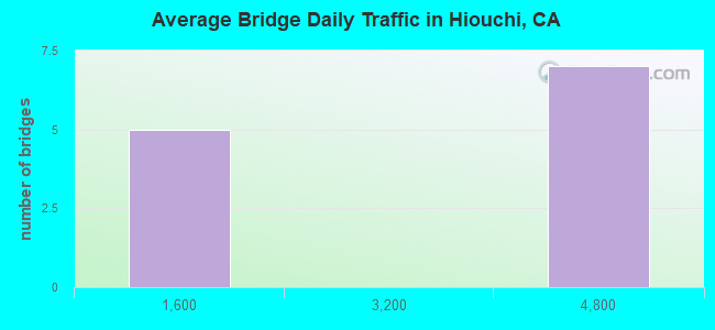
- 30,733Total average daily traffic
- 3,363Total average daily truck traffic
- 42,672Total future (year 2040) average daily traffic
- National Bridge Inventory (NBI) Registered Bridges for Hiouchi
- No street view available for this location
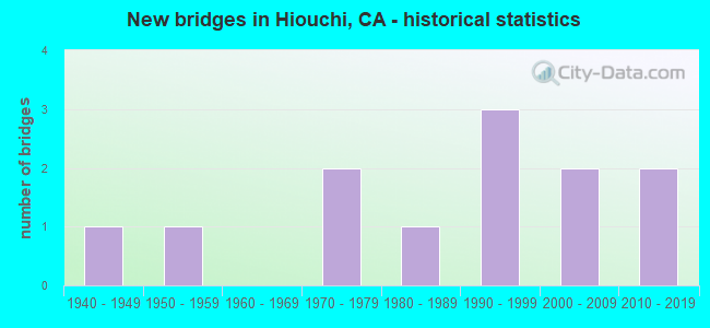
- New bridges - historical statistics
- 11940-1949
- 11950-1959
- 21970-1979
- 11980-1989
- 31990-1999
- 22000-2009
- 22010-2019
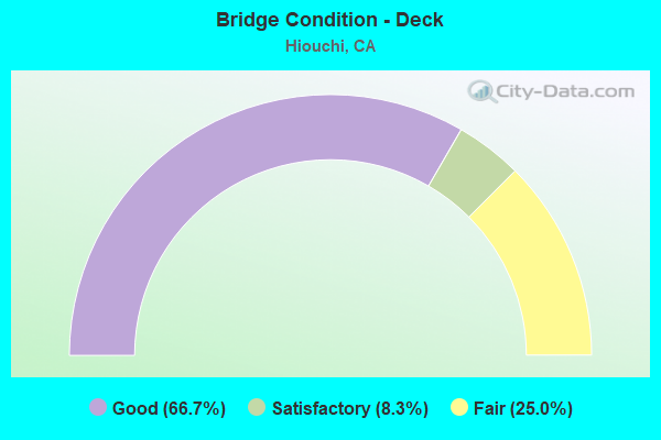
- Bridge Condition - Deck
- 66.7%Good
- 8.3%Satisfactory
- 25.0%Fair
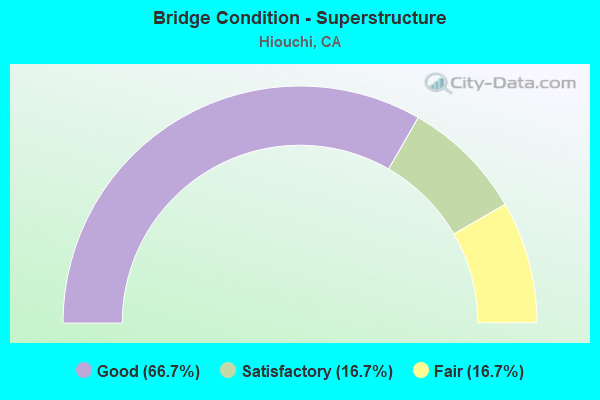
- Bridge Condition - Superstructure
- 66.7%Good
- 16.7%Satisfactory
- 16.7%Fair
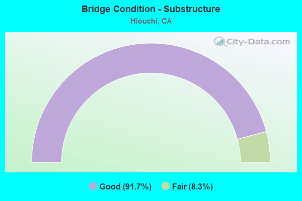
- Bridge Condition - Substructure
- 91.7%Good
- 8.3%Fair
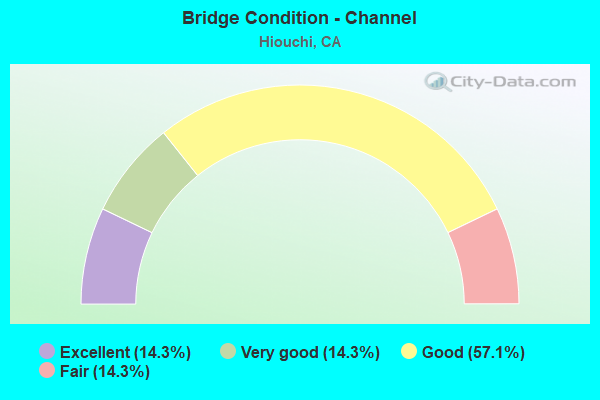
- Bridge Condition - Channel
- 14.3%Excellent
- 14.3%Very good
- 57.1%Good
- 14.3%Fair
Find on map >> Show street view
Structure Number: 1 0006, Location: 01-DN-199-4.22 (Lat: 41.806692, Lng: -124.082539), Route carried "on" structure: US 199, Year Built: 1990, Status: Open, Structure Length: 20.85m (68.41ft), Average Daily Traffic: 4,300 (year 2009), Truck Traffic: 11%, Average Future Daily Traffic: 6,019 (year 2040), Design Load: HS 20+Mod, Features Intersected: SMITH RIVER
Minimum Vertical Clearance: 30+ m (98+ ft), Kilometerpoint: 4.220, Lanes on structure: 2, Base Highway Network: Yes (Inventory Route: 1, Subroute: 1), Owner: State Highway Agency, Approaching Roadway Width: 12.2m (40.0ft), Skew: 3 degrees, Material/Design: Prestressed concrete continuous, Design/Construction: Box Beam or Girders - Multiple, Number Of Spans In Main Unit: 3, Length of Maximum Span: 106.7m (350.1ft), Curb-To-Curb Width: 11.0m (36.1ft), Out-to-Out Width: 12.2m (40.0ft)
Condition: Deck: Good, Superstructure: Good, Substructure: Good, Channel: Good, Operating Rating: 54.1 metric tons, Method Used To Determine Operating Rating: Assigned rating based on Load Factor Design (LFD) reported in metric tons, Inventory Rating: 32.4 metric tons, Method Used To Determine Inventory Rating: Assigned rating based on Load Factor Design (LFD) reported in metric tons, Structural Evaluation: Better than present minimum criteria, Deck Geometry: Somewhat better than minimum adequacy, Waterway Adequacy: Superior to present desirable criteria, Approach Roadway Alignment: Better than present minimum criteria, Designated Inspection Frequency: Every 24 months, Inspection Date: September 2020, Deck Structure Type: Concrete Cast-file-Place
Find on map >> Show street view
Structure Number: 1 0007, Location: 01-DN-199-7.09 (Lat: 41.801322, Lng: -124.055742), Route carried "on" structure: US 199, Year Built: 1984, Status: Open, Structure Length: 7.62m (25.00ft), Average Daily Traffic: 4,300 (year 2009), Truck Traffic: 11%, Average Future Daily Traffic: 6,019 (year 2040), Design Load: HS 20+Mod, Features Intersected: MYRTLE CREEK
Minimum Vertical Clearance: 30+ m (98+ ft), Kilometerpoint: 7.090, Lanes on structure: 2, Base Highway Network: Yes (Inventory Route: 1, Subroute: 1), Owner: State Highway Agency, Approaching Roadway Width: 9.8m (32.2ft), Material/Design: Concrete continuous, Design/Construction: Arch - Deck, Number Of Spans In Main Unit: 1, Number Of Approach Spans: 6, Length of Maximum Span: 38.4m (126.0ft), Curb-To-Curb Width: 9.8m (32.2ft), Out-to-Out Width: 10.8m (35.4ft)
Condition: Deck: Good, Superstructure: Good, Substructure: Good, Channel: Very good, Operating Rating: 54.1 metric tons, Method Used To Determine Operating Rating: Assigned rating based on Load Factor Design (LFD) reported in metric tons, Inventory Rating: 32.4 metric tons, Method Used To Determine Inventory Rating: Assigned rating based on Load Factor Design (LFD) reported in metric tons, Structural Evaluation: Better than present minimum criteria, Deck Geometry: Meets minimum limits, Waterway Adequacy: Superior to present desirable criteria, Approach Roadway Alignment: Equal to present desirable criteria, Designated Inspection Frequency: Every 24 months, Inspection Date: September 2020, Deck Structure Type: Concrete Cast-file-Place
Find on map >> Show street view
Structure Number: 1 007, Location: 01-DN-199-8.66 (Lat: 41.816536, Lng: -124.038883), Route carried "on" structure: US 199, Year Built: 1979, Status: Open, Structure Length: 5.12m (16.80ft), Average Daily Traffic: 3,750 (year 2009), Truck Traffic: 13%, Average Future Daily Traffic: 4,693 (year 2040), Design Load: HS 20+Mod, Features Intersected: HILLSIDE ABOVE RIVER
Minimum Vertical Clearance: 30+ m (98+ ft), Kilometerpoint: 8.660, Lanes on structure: 2, Base Highway Network: Yes (Inventory Route: 1, Subroute: 1), Owner: State Highway Agency, Approaching Roadway Width: 8.2m (26.9ft), Material/Design: Concrete continuous, Design/Construction: Slab, Number Of Spans In Main Unit: 6, Length of Maximum Span: 9.1m (29.9ft), Curb-To-Curb Width: 9.8m (32.2ft), Out-to-Out Width: 5.4m (17.7ft)
Condition: Deck: Good, Superstructure: Good, Substructure: Good, Operating Rating: 82.6 metric tons, Method Used To Determine Operating Rating: Load Factor (LF), Inventory Rating: 49.9 metric tons, Method Used To Determine Inventory Rating: Load Factor (LF), Structural Evaluation: Better than present minimum criteria, Deck Geometry: Meets minimum limits, Approach Roadway Alignment: Equal to present desirable criteria, Designated Inspection Frequency: Every 24 months, Inspection Date: September 2020, Deck Structure Type: Concrete Cast-file-Place, Wearing Surface/Protective System: Wearing Surface: Bituminous
Find on map >> Show street view
Structure Number: 1 0074, Location: 01-DN-199-7.32 (Lat: 41.803783, Lng: -124.052442), Route carried "on" structure: US 199, Year Built: 1994, Status: Open, Structure Length: 3.12m (10.24ft), Average Daily Traffic: 4,300 (year 2009), Truck Traffic: 11%, Average Future Daily Traffic: 6,019 (year 2040), Design Load: HS 20+Mod, Features Intersected: HILLSIDE ABOVE RIVER
Minimum Vertical Clearance: 30+ m (98+ ft), Kilometerpoint: 7.320, Lanes on structure: 2, Base Highway Network: Yes (Inventory Route: 1, Subroute: 1), Owner: State Highway Agency, Approaching Roadway Width: 9.8m (32.2ft), Material/Design: Concrete, Design/Construction: Box Beam or Girders - Multiple, Number Of Spans In Main Unit: 1, Length of Maximum Span: 30.0m (98.4ft), Curb-To-Curb Width: 9.8m (32.2ft), Out-to-Out Width: 5.1m (16.7ft)
Condition: Deck: Good, Superstructure: Good, Substructure: Good, Operating Rating: 54.1 metric tons, Method Used To Determine Operating Rating: Assigned rating based on Load Factor Design (LFD) reported in metric tons, Inventory Rating: 32.4 metric tons, Method Used To Determine Inventory Rating: Assigned rating based on Load Factor Design (LFD) reported in metric tons, Structural Evaluation: Better than present minimum criteria, Deck Geometry: Meets minimum limits, Approach Roadway Alignment: Equal to present desirable criteria, Designated Inspection Frequency: Every 48 months, Inspection Date: September 2020, Deck Structure Type: Concrete Cast-file-Place
Find on map >> Show street view
Structure Number: 1 0075, Location: 01-DN-199-7.41 (Lat: 41.804750, Lng: -124.052175), Route carried "on" structure: US 199, Year Built: 1994, Status: Open, Structure Length: 2.85m (9.35ft), Average Daily Traffic: 4,300 (year 2009), Truck Traffic: 11%, Average Future Daily Traffic: 5,976 (year 2040), Design Load: HS 20+Mod, Features Intersected: HILLSIDE ABOVE RIVER
Minimum Vertical Clearance: 30+ m (98+ ft), Kilometerpoint: 7.410, Lanes on structure: 2, Base Highway Network: Yes (Inventory Route: 1, Subroute: 1), Owner: State Highway Agency, Approaching Roadway Width: 9.8m (32.2ft), Material/Design: Concrete, Design/Construction: Box Beam or Girders - Multiple, Number Of Spans In Main Unit: 1, Length of Maximum Span: 28.0m (91.9ft), Curb-To-Curb Width: 9.8m (32.2ft), Out-to-Out Width: 5.5m (18.0ft)
Condition: Deck: Fair, Superstructure: Good, Substructure: Good, Operating Rating: 54.1 metric tons, Method Used To Determine Operating Rating: Assigned rating based on Load Factor Design (LFD) reported in metric tons, Inventory Rating: 32.4 metric tons, Method Used To Determine Inventory Rating: Assigned rating based on Load Factor Design (LFD) reported in metric tons, Structural Evaluation: Better than present minimum criteria, Deck Geometry: Meets minimum limits, Approach Roadway Alignment: Equal to present desirable criteria, Designated Inspection Frequency: Every 24 months, Inspection Date: September 2020, Deck Structure Type: Concrete Cast-file-Place
Find on map >> Show street view
Structure Number: 1 0078, Location: 01-DN-199-7.50 (Lat: 41.806439, Lng: -124.052036), Route carried "on" structure: US 199, Year Built: 2005, Status: Open, Structure Length: 2.42m (7.94ft), Average Daily Traffic: 4,300 (year 2009), Truck Traffic: 11%, Average Future Daily Traffic: 5,900 (year 2040), Design Load: HS 20+Mod, Features Intersected: HILLSIDE ABOVE RIVER
Minimum Vertical Clearance: 30+ m (98+ ft), Kilometerpoint: 7.500, Lanes on structure: 2, Base Highway Network: Yes (Inventory Route: 1, Subroute: 1), Owner: State Highway Agency, Approaching Roadway Width: 9.6m (31.5ft), Material/Design: Prestressed concrete, Design/Construction: Stringer/Multi-beam, Number Of Spans In Main Unit: 1, Length of Maximum Span: 22.9m (75.1ft), Curb-To-Curb Width: 9.6m (31.5ft), Out-to-Out Width: 3.7m (12.1ft)
Condition: Deck: Good, Superstructure: Good, Substructure: Good, Operating Rating: 54.1 metric tons, Method Used To Determine Operating Rating: Assigned rating based on Load Factor Design (LFD) reported in metric tons, Inventory Rating: 32.4 metric tons, Method Used To Determine Inventory Rating: Assigned rating based on Load Factor Design (LFD) reported in metric tons, Structural Evaluation: Better than present minimum criteria, Deck Geometry: Meets minimum limits, Approach Roadway Alignment: Equal to present desirable criteria, Designated Inspection Frequency: Every 48 months, Inspection Date: September 2020, Deck Structure Type: Concrete Cast-file-Place, Wearing Surface/Protective System: Wearing Surface: Bituminous
Find on map >> Show street view
Structure Number: 1 0081, Location: 01-DN-199-8.20 (Lat: 41.808042, Lng: -124.051764), Route carried "on" structure: State highway 199, Year Built: 2017, Status: Open, Structure Length: 6.75m (22.15ft), Average Daily Traffic: 4,300 (year 2009), Truck Traffic: 11%, Average Future Daily Traffic: 5,900 (year 2040), Design Load: HL 93, Features Intersected: HILLSIDE ABOVE RIVER
Minimum Vertical Clearance: 30+ m (98+ ft), Kilometerpoint: 8.200, Lanes on structure: 1, Base Highway Network: Yes (Inventory Route: 1, Subroute: 1), Owner: State Highway Agency, Approaching Roadway Width: 12.8m (42.0ft), Skew: 9 degrees, Material/Design: Concrete continuous, Design/Construction: Slab, Number Of Spans In Main Unit: 7, Length of Maximum Span: 10.2m (33.5ft), Curb-To-Curb Width: 12.8m (42.0ft), Out-to-Out Width: 6.7m (22.0ft)
Condition: Deck: Satisfactory, Superstructure: Satisfactory, Substructure: Good, Operating Rating: 54.0 metric tons, Method Used To Determine Operating Rating: Field evaluation and documented engineering judgment, Inventory Rating: 32.4 metric tons, Method Used To Determine Inventory Rating: Field evaluation and documented engineering judgment, Structural Evaluation: Equal to present minimum criteria, Deck Geometry: Equal to present minimum criteria, Approach Roadway Alignment: Equal to present desirable criteria, Designated Inspection Frequency: Every 48 months, Inspection Date: September 2020, Deck Structure Type: Concrete Cast-file-Place, Wearing Surface/Protective System: Deck Protection: Bituminous
Find on map >> Show street view
Structure Number: 1C0006, Location: 0.05 MI SE JCT SR199 (Lat: 41.801228, Lng: -124.053206), Route carried "on" structure: County highway , Year Built: 1956, Status: Open, Structure Length: 7.92m (25.98ft), Average Daily Traffic: 350 (year 2000), Truck Traffic: 3%, Average Future Daily Traffic: 764 (year 2041), Design Load: H 20, Features Intersected: MIDDLE FORK SMITH RIVER, Facility Carried by Structure: SOUTH FORK ROAD
Minimum Vertical Clearance: 30+ m (98+ ft), Kilometerpoint: 0.000, Lanes on structure: 2, Owner: County Highway Agency, Approaching Roadway Width: 7.5m (24.6ft), Material/Design: Steel, Design/Construction: Stringer/Multi-beam, Number Of Spans In Main Unit: 4, Length of Maximum Span: 25.6m (84.0ft), Curb or Sidewalk Widths: Left: 0.4m (1.3ft), Right: 0.4m (1.3ft), Curb-To-Curb Width: 6.7m (22.0ft), Out-to-Out Width: 7.5m (24.6ft)
Condition: Deck: Fair, Superstructure: Fair, Substructure: Good, Channel: Good, Operating Rating: 60.6 metric tons, Method Used To Determine Operating Rating: Load Factor (LF), Inventory Rating: 36.3 metric tons, Method Used To Determine Inventory Rating: Load Factor (LF), Structural Evaluation: Somewhat better than minimum adequacy, Deck Geometry: Meets minimum limits, Waterway Adequacy: Superior to present desirable criteria, Approach Roadway Alignment: Equal to present minimum criteria, Designated Inspection Frequency: Every 24 months, Critical Feature Inspection Frequency: Every 24 months, Inspection Date: July 2021, Critical Feature Inspection Date: October 2020, Deck Structure Type: Concrete Cast-file-Place
Find on map >> Show street view
Structure Number: 1C0022, Location: 0.74 MI S/O SOUTH FORK RD (Lat: 41.788156, Lng: -124.055575), Route carried "on" structure: County highway , Year Built: 1975, Status: Open, Structure Length: 1.22m (4.00ft), Average Daily Traffic: 140 (year 2004), Truck Traffic: 1%, Average Future Daily Traffic: 216 (year 2042), Design Load: H 15, Features Intersected: SHEEP PEN CREEK, Facility Carried by Structure: DOUGLAS PARK ROAD
Minimum Vertical Clearance: 5.53m (18.14ft), Kilometerpoint: 0.000, Lanes on structure: 2, Owner: County Highway Agency, Approaching Roadway Width: 7.6m (24.9ft), Material/Design: Wood or Timber, Design/Construction: Stringer/Multi-beam, Number Of Spans In Main Unit: 1, Length of Maximum Span: 10.4m (34.1ft), Curb or Sidewalk Widths: Left: 0.0m, Right: 0.2m (0.7ft), Curb-To-Curb Width: 8.7m (28.5ft), Out-to-Out Width: 9.8m (32.2ft)
Condition: Deck: Good, Superstructure: Good, Substructure: Good, Channel: Good, Operating Rating: 29.8 metric tons, Method Used To Determine Operating Rating: Allowable Stress (AS), Inventory Rating: 21.1 metric tons, Method Used To Determine Inventory Rating: Allowable Stress (AS), Structural Evaluation: Equal to present minimum criteria, Deck Geometry: Equal to present minimum criteria, Waterway Adequacy: Better than present minimum criteria, Approach Roadway Alignment: Better than present minimum criteria, Designated Inspection Frequency: Every 24 months, Inspection Date: August 2020, Deck Structure Type: Wood or Timber
Find on map >> Show street view
Structure Number: 1C0039, Location: 0.2 MI NORTH OF RTE 199 (Lat: 41.812717, Lng: -124.109267), Route carried "on" structure: County highway , Year Built: 2002, Status: Open, Structure Length: 2.13m (6.99ft), Average Daily Traffic: 25 (year 2003), Truck Traffic: 1%, Average Future Daily Traffic: 54 (year 2041), Design Load: HS 20, Features Intersected: CLARKS CREEK, Facility Carried by Structure: WALKER ROAD
Minimum Vertical Clearance: 30+ m (98+ ft), Kilometerpoint: 0.000, Lanes on structure: 1, Owner: County Highway Agency, Approaching Roadway Width: 7.3m (24.0ft), Material/Design: Steel, Design/Construction: Stringer/Multi-beam, Number Of Spans In Main Unit: 1, Length of Maximum Span: 20.6m (67.6ft), Curb-To-Curb Width: 5.9m (19.4ft), Out-to-Out Width: 6.1m (20.0ft)
Condition: Deck: Good, Superstructure: Satisfactory, Substructure: Good, Channel: Excellent, Operating Rating: 58.0 metric tons, Method Used To Determine Operating Rating: Load Factor (LF), Inventory Rating: 34.7 metric tons, Method Used To Determine Inventory Rating: Load Factor (LF), Structural Evaluation: Equal to present minimum criteria, Deck Geometry: Meets minimum limits, Waterway Adequacy: Better than present minimum criteria, Approach Roadway Alignment: Equal to present minimum criteria, Designated Inspection Frequency: Every 48 months, Other Special Inspection Frequency: Every 48 months, Inspection Date: July 2019, Other Special Inspection Date: July 2019, Deck Structure Type: Corrugated Steel, Wearing Surface/Protective System: Wearing Surface: Bituminous
Find on map >> Show street view
Structure Number: 1C0046, Location: 0.4 MI SE OF US 199 (Lat: 41.796864, Lng: -124.054275), Route carried "on" structure: County highway , Year Built: 2017, Status: Open, Structure Length: 7.04m (23.10ft), Average Daily Traffic: 568 (year 2014), Truck Traffic: 3%, Average Future Daily Traffic: 950 (year 2041), Design Load: HL 93, Features Intersected: SOUTH FORK SMITH RIVER, Facility Carried by Structure: SOUTH FORK ROAD
Minimum Vertical Clearance: 30+ m (98+ ft), Kilometerpoint: 0.000, Lanes on structure: 2, Owner: County Highway Agency, Approaching Roadway Width: 10.7m (35.1ft), Material/Design: Concrete, Design/Construction: Arch - Deck, Number Of Spans In Main Unit: 1, Number Of Approach Spans: 2, Length of Maximum Span: 43.0m (141.1ft), Curb-To-Curb Width: 9.8m (32.2ft), Out-to-Out Width: 10.9m (35.8ft)
Condition: Deck: Good, Superstructure: Good, Substructure: Good, Channel: Good, Operating Rating: 42.1 metric tons, Method Used To Determine Operating Rating: Assigned ratings based on Load and Resistance Factor Design (LRFD) reported by rating factor (RF) using HL93 loadings, Inventory Rating: 32.4 metric tons, Method Used To Determine Inventory Rating: Assigned ratings based on Load and Resistance Factor Design (LRFD) reported by rating factor (RF) using HL93 loadings, Structural Evaluation: Better than present minimum criteria, Deck Geometry: Equal to present minimum criteria, Waterway Adequacy: Better than present minimum criteria, Approach Roadway Alignment: Equal to present desirable criteria, Designated Inspection Frequency: Every 24 months, Inspection Date: July 2021, Deck Structure Type: Concrete Cast-file-Place, Wearing Surface/Protective System: Wearing Surface: Integral Concrete
Find on map >> Show street view
Structure Number: 1P0005, Location: JEDEDIAH SMITH STATE PARK (Lat: 41.774125, Lng: -124.099964), Route carried "on" structure: State lands road , Year Built: 1949, Status: Open, Structure Length: 4.48m (14.70ft), Average Daily Traffic: 100 (year 2004), Truck Traffic: 10%, Average Future Daily Traffic: 162 (year 2042), Design Load: H 15, Features Intersected: MILL CREEK, Facility Carried by Structure: BREEN MEMORIAL RD
Minimum Vertical Clearance: 30+ m (98+ ft), Kilometerpoint: 0.000, Lanes on structure: 1, Owner: State Park, Forest, or Reservation Agency, Approaching Roadway Width: 4.3m (14.1ft), Material/Design: Concrete continuous, Design/Construction: Slab, Number Of Spans In Main Unit: 4, Length of Maximum Span: 11.0m (36.1ft), Curb or Sidewalk Widths: Left: 0.3m (1.0ft), Right: 0.3m (1.0ft), Curb-To-Curb Width: 3.5m (11.5ft), Out-to-Out Width: 6.9m (22.6ft)
Condition: Deck: Fair, Superstructure: Fair, Substructure: Fair, Channel: Fair, Operating Rating: 29.5 metric tons, Method Used To Determine Operating Rating: Load and Resistance Factor Rating (LRFR) rating reported by rating factor(RF) method using HL-93 loadings, Inventory Rating: 22.7 metric tons, Method Used To Determine Inventory Rating: Load and Resistance Factor Rating (LRFR) rating reported by rating factor(RF) method using HL-93 loadings, Structural Evaluation: Somewhat better than minimum adequacy, Deck Geometry: High priority of corrective action, Waterway Adequacy: Equal to present desirable criteria, Approach Roadway Alignment: Equal to present minimum criteria, Designated Inspection Frequency: Every 24 months, Inspection Date: August 2020, Deck Structure Type: Concrete Cast-file-Place