Bridge Statistics for Holtville, California (CA)
Condition, Traffic, Stress, Structural Evaluation, Project Costs
- National Bridge Inventory (NBI) Statistics
- 23Number of bridges
- 276ft / 84.4mTotal length
- $569,000Total costs
- 145,943Total average daily traffic
- 34,613Total average daily truck traffic
- National Bridge Inventory (NBI) Registered Bridges for Holtville
- No street view available for this location
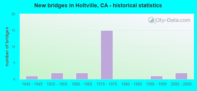
- New bridges - historical statistics
- 11940-1949
- 21950-1959
- 21960-1969
- 151970-1979
- 11990-1999
- 22000-2009
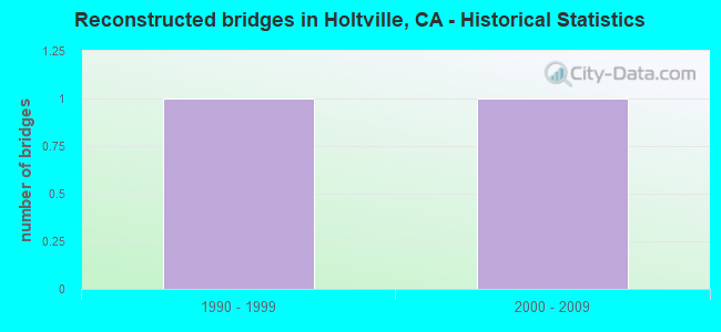
- Reconstructed bridges - Historical Statistics
- 11990-1999
- 12000-2009
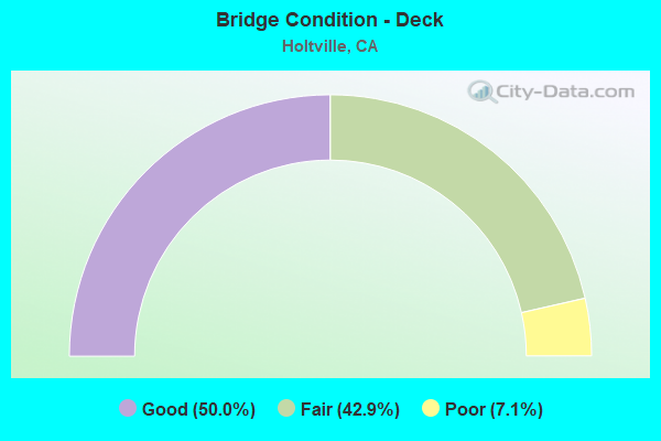
- Bridge Condition - Deck
- 50.0%Good
- 42.9%Fair
- 7.1%Poor
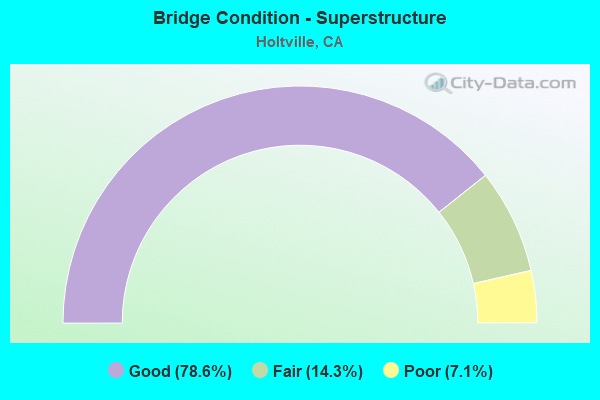
- Bridge Condition - Superstructure
- 78.6%Good
- 14.3%Fair
- 7.1%Poor
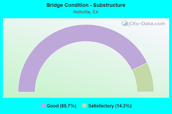
- Bridge Condition - Substructure
- 85.7%Good
- 14.3%Satisfactory
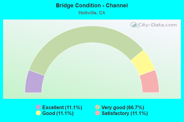
- Bridge Condition - Channel
- 11.1%Excellent
- 66.7%Very good
- 11.1%Good
- 11.1%Satisfactory
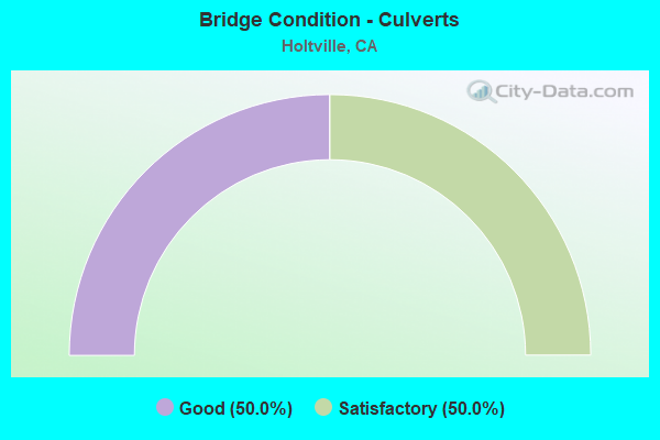
- Bridge Condition - Culverts
- 50.0%Good
- 50.0%Satisfactory
Find on map >> Show street view
Structure Number: 58 0006L, Location: 11-IMP-086-17.82 (Lat: 32.948933, Lng: -115.569472), Route carried "on" structure: State highway 86, Year Built: 1948, Status: Open, Structure Length: 3.96m (12.99ft), Average Daily Traffic: 7,700 (year 2018), Truck Traffic: 16%, Average Future Daily Traffic: 14,330 (year 2040), Design Load: HS 20, Features Intersected: CENTRAL MAIN CANAL
Minimum Vertical Clearance: 30+ m (98+ ft), Kilometerpoint: 17.820, Lanes on structure: 2, Base Highway Network: Yes (, Subroute: 1), Owner: State Highway Agency, Approaching Roadway Width: 8.0m (26.2ft), Skew: 6 degrees, Material/Design: Steel, Design/Construction: Stringer/Multi-beam, Number Of Spans In Main Unit: 1, Number Of Approach Spans: 2, Length of Maximum Span: 16.8m (55.1ft), Curb-To-Curb Width: 8.0m (26.2ft), Out-to-Out Width: 9.8m (32.2ft)
Condition: Deck: Good, Superstructure: Good, Substructure: Good, Channel: Satisfactory, Operating Rating: 48.9 metric tons, Method Used To Determine Operating Rating: Load Factor (LF), Inventory Rating: 29.5 metric tons, Method Used To Determine Inventory Rating: Load Factor (LF), Structural Evaluation: Better than present minimum criteria, Deck Geometry: High priority of replacement, Waterway Adequacy: Equal to present minimum criteria, Approach Roadway Alignment: Meets minimum limits, Designated Inspection Frequency: Every 24 months, Critical Feature Inspection Frequency: Every 24 months, Inspection Date: January 2022, Critical Feature Inspection Date: Febuary 2021, Deck Structure Type: Concrete Cast-file-Place, Wearing Surface/Protective System: Wearing Surface: Bituminous
Find on map >> Show street view
Structure Number: 58 0007, Location: 11-IMP-115-L10.31-HOLT (Lat: 32.807719, Lng: -115.388142), Route carried "on" structure: State highway 115, Year Built: 1955, Year Reconstructed: 1990, Status: Open, Structure Length: 7.68m (25.20ft), Average Daily Traffic: 5,400 (year 2011), Truck Traffic: 40%, Average Future Daily Traffic: 8,906 (year 2037), Design Load: HS 20, Features Intersected: ALAMO RIVER
Minimum Vertical Clearance: 30+ m (98+ ft), Kilometerpoint: 10.310, Lanes on structure: 2, Owner: State Highway Agency, Approaching Roadway Width: 13.0m (42.7ft), Material/Design: Concrete continuous, Design/Construction: Tee Beam, Number Of Spans In Main Unit: 6, Length of Maximum Span: 13.7m (44.9ft), Curb-To-Curb Width: 13.0m (42.7ft), Out-to-Out Width: 14.0m (45.9ft)
Condition: Deck: Good, Superstructure: Good, Substructure: Good, Channel: Very good, Operating Rating: 54.1 metric tons, Method Used To Determine Operating Rating: Assigned rating based on Load Factor Design (LFD) reported in metric tons, Inventory Rating: 32.4 metric tons, Method Used To Determine Inventory Rating: Assigned rating based on Load Factor Design (LFD) reported in metric tons, Structural Evaluation: Better than present minimum criteria, Deck Geometry: Somewhat better than minimum adequacy, Waterway Adequacy: Equal to present desirable criteria, Approach Roadway Alignment: Equal to present desirable criteria, Designated Inspection Frequency: Every 24 months, Inspection Date: August 2020, Deck Structure Type: Concrete Cast-file-Place
Find on map >> Show street view
Structure Number: 58 0216, Location: 11-IMP-008-R45.05 (Lat: 32.773742, Lng: -115.430756), Route carried "on" structure: County highway Y582, Year Built: 1971, Status: Open, Structure Length: 6.34m (20.80ft), Average Daily Traffic: 1,080 (year 2019), Truck Traffic: 1%, Average Future Daily Traffic: 2,628 (year 2038), Design Load: HS 20, Features Intersected: INTERSTATE 8, Facility Carried by Structure: BARBARA WORTH RD
Minimum Vertical Clearance: 30+ m (98+ ft), Kilometerpoint: 0.000, Lanes on structure: 2, Lanes under structure: 4, Owner: State Highway Agency, Approaching Roadway Width: 9.8m (32.2ft), Material/Design: Concrete continuous, Design/Construction: Box Beam or Girders - Multiple, Number Of Spans In Main Unit: 2, Length of Maximum Span: 31.4m (103.0ft), Curb-To-Curb Width: 9.8m (32.2ft), Out-to-Out Width: 10.4m (34.1ft)
Condition: Deck: Good, Superstructure: Good, Substructure: Satisfactory, Operating Rating: 58.3 metric tons, Method Used To Determine Operating Rating: Load and Resistance Factor Rating (LRFR) rating reported by rating factor(RF) method using HL-93 loadings, Inventory Rating: 45.0 metric tons, Method Used To Determine Inventory Rating: Load and Resistance Factor Rating (LRFR) rating reported by rating factor(RF) method using HL-93 loadings, Structural Evaluation: Equal to present minimum criteria, Deck Geometry: Somewhat better than minimum adequacy, Underclear: Equal to present minimum criteria, Approach Roadway Alignment: Equal to present desirable criteria, Designated Inspection Frequency: Every 24 months, Inspection Date: March 2020, Deck Structure Type: Concrete Cast-file-Place
Find on map >> Show street view
Structure Number: 58 0217, Location: 11-IMP-008-R47.05 (Lat: 32.773611, Lng: -115.396425), Route carried "on" structure: County highway , Year Built: 1971, Status: Open, Structure Length: 6.34m (20.80ft), Average Daily Traffic: 750 (year 2020), Truck Traffic: 1%, Average Future Daily Traffic: 1,577 (year 2038), Design Load: HS 20, Features Intersected: INTERSTATE 8, Facility Carried by Structure: METZ ROAD
Minimum Vertical Clearance: 30+ m (98+ ft), Kilometerpoint: 0.000, Lanes on structure: 2, Lanes under structure: 4, Owner: State Highway Agency, Approaching Roadway Width: 9.8m (32.2ft), Material/Design: Concrete continuous, Design/Construction: Box Beam or Girders - Multiple, Number Of Spans In Main Unit: 2, Length of Maximum Span: 31.4m (103.0ft), Curb-To-Curb Width: 9.8m (32.2ft), Out-to-Out Width: 10.4m (34.1ft)
Condition: Deck: Good, Superstructure: Good, Substructure: Good, Operating Rating: 56.7 metric tons, Method Used To Determine Operating Rating: Load and Resistance Factor Rating (LRFR) rating reported by rating factor(RF) method using HL-93 loadings, Inventory Rating: 43.7 metric tons, Method Used To Determine Inventory Rating: Load and Resistance Factor Rating (LRFR) rating reported by rating factor(RF) method using HL-93 loadings, Structural Evaluation: Better than present minimum criteria, Deck Geometry: Equal to present minimum criteria, Underclear: Equal to present minimum criteria, Approach Roadway Alignment: Equal to present desirable criteria, Designated Inspection Frequency: Every 24 months, Inspection Date: January 2021, Deck Structure Type: Concrete Cast-file-Place
Find on map >> Show street view
Structure Number: 58 0218, Location: 11-IMP-008-R47.78 (Lat: 32.773567, Lng: -115.383778), Route carried "on" structure: County highway W976, Year Built: 1971, Year Reconstructed: 2005, Status: Open, Structure Length: 6.34m (20.80ft), Average Daily Traffic: 2,210 (year 2020), Truck Traffic: 5%, Average Future Daily Traffic: 4,730 (year 2038), Design Load: HS 20, Features Intersected: INTERSTATE 8, Facility Carried by Structure: ORCHARD ROAD
Minimum Vertical Clearance: 30+ m (98+ ft), Kilometerpoint: 0.000, Lanes on structure: 3, Lanes under structure: 6, Owner: State Highway Agency, Approaching Roadway Width: 19.7m (64.6ft), Material/Design: Concrete continuous, Design/Construction: Box Beam or Girders - Multiple, Number Of Spans In Main Unit: 2, Length of Maximum Span: 31.9m (104.7ft), Curb-To-Curb Width: 19.7m (64.6ft), Out-to-Out Width: 20.7m (67.9ft)
Condition: Deck: Good, Superstructure: Good, Substructure: Good, Operating Rating: 71.6 metric tons, Method Used To Determine Operating Rating: Load Factor (LF), Inventory Rating: 36.9 metric tons, Method Used To Determine Inventory Rating: Load Factor (LF), Structural Evaluation: Better than present minimum criteria, Deck Geometry: Superior to present desirable criteria, Underclear: Equal to present minimum criteria, Approach Roadway Alignment: Superior to present desirable criteria, Designated Inspection Frequency: Every 24 months, Inspection Date: January 2021, Deck Structure Type: Concrete Cast-file-Place
Find on map >> Show street view
Structure Number: 58 0219, Location: 11-IMP-008-R49.75 (Lat: 32.773147, Lng: -115.349906), Route carried "on" structure: Interstate 8, Year Built: 1971, Status: Open, Structure Length: 1.65m (5.41ft), Average Daily Traffic: 11,400 (year 2020), Truck Traffic: 20%, Average Future Daily Traffic: 13,670 (year 2038), Design Load: HS 20, Features Intersected: ALAMO RIVER
Minimum Vertical Clearance: 30+ m (98+ ft), Kilometerpoint: 49.750, Lanes on structure: 4, Base Highway Network: Yes (, Subroute: 3), Owner: State Highway Agency, Approaching Roadway Width: 13.5m (44.3ft), Skew: 21 degrees, Material/Design: Concrete continuous, Design/Construction: Culvert, Number Of Spans In Main Unit: 2, Length of Maximum Span: 7.6m (24.9ft), Curb-To-Curb Width: 13.5m (44.3ft), Out-to-Out Width: 27.0m (88.6ft)
Condition: Channel: Good, Culverts: Good, Operating Rating: 54.1 metric tons, Method Used To Determine Operating Rating: Field evaluation and documented engineering judgment, Inventory Rating: 32.4 metric tons, Method Used To Determine Inventory Rating: Field evaluation and documented engineering judgment, Structural Evaluation: Better than present minimum criteria, Deck Geometry: High priority of replacement, Waterway Adequacy: Equal to present desirable criteria, Approach Roadway Alignment: Superior to present desirable criteria, Designated Inspection Frequency: Every 24 months, Underwater Inspection Frequency: Every 60 months, Inspection Date: January 2021, Underwater Inspection Date: December 2020
Find on map >> Show street view
Structure Number: 58 022, Location: 11-IMP-008-R50.49 (Lat: 32.773597, Lng: -115.337228), Route carried "on" structure: County highway W977, Year Built: 1971, Status: Open, Structure Length: 6.34m (20.80ft), Average Daily Traffic: 1,100 (year 2020), Truck Traffic: 2%, Average Future Daily Traffic: 2,628 (year 2038), Design Load: HS 20, Features Intersected: INTERSTATE 8, Facility Carried by Structure: BONDS CORNER ROAD
Minimum Vertical Clearance: 30+ m (98+ ft), Kilometerpoint: 0.000, Lanes on structure: 2, Lanes under structure: 4, Owner: State Highway Agency, Approaching Roadway Width: 12.2m (40.0ft), Material/Design: Concrete continuous, Design/Construction: Box Beam or Girders - Multiple, Number Of Spans In Main Unit: 2, Length of Maximum Span: 31.4m (103.0ft), Curb-To-Curb Width: 12.2m (40.0ft), Out-to-Out Width: 12.8m (42.0ft)
Condition: Deck: Good, Superstructure: Good, Substructure: Good, Operating Rating: 66.1 metric tons, Method Used To Determine Operating Rating: Load and Resistance Factor Rating (LRFR) rating reported by rating factor(RF) method using HL-93 loadings, Inventory Rating: 51.2 metric tons, Method Used To Determine Inventory Rating: Load and Resistance Factor Rating (LRFR) rating reported by rating factor(RF) method using HL-93 loadings, Structural Evaluation: Better than present minimum criteria, Deck Geometry: Better than present minimum criteria, Underclear: Equal to present minimum criteria, Approach Roadway Alignment: Equal to present desirable criteria, Designated Inspection Frequency: Every 24 months, Inspection Date: January 2021, Deck Structure Type: Concrete Cast-file-Place
Find on map >> Show street view
Structure Number: 58 0279, Location: 11-IMP-008-R46.05 (Lat: 32.773667, Lng: -115.413456), Route carried "on" structure: County highway , Year Built: 1971, Status: Open, Structure Length: 6.34m (20.80ft), Average Daily Traffic: 860 (year 2019), Truck Traffic: 2%, Average Future Daily Traffic: 1,577 (year 2038), Design Load: HS 20, Features Intersected: INTERSTATE 8, Facility Carried by Structure: ANDERHOLT ROAD
Minimum Vertical Clearance: 30+ m (98+ ft), Kilometerpoint: 0.000, Lanes on structure: 2, Lanes under structure: 4, Owner: State Highway Agency, Approaching Roadway Width: 9.8m (32.2ft), Material/Design: Concrete continuous, Design/Construction: Box Beam or Girders - Multiple, Number Of Spans In Main Unit: 2, Length of Maximum Span: 31.4m (103.0ft), Curb-To-Curb Width: 9.8m (32.2ft), Out-to-Out Width: 10.4m (34.1ft)
Condition: Deck: Fair, Superstructure: Good, Substructure: Satisfactory, Operating Rating: 56.1 metric tons, Method Used To Determine Operating Rating: Load and Resistance Factor Rating (LRFR) rating reported by rating factor(RF) method using HL-93 loadings, Inventory Rating: 43.1 metric tons, Method Used To Determine Inventory Rating: Load and Resistance Factor Rating (LRFR) rating reported by rating factor(RF) method using HL-93 loadings, Structural Evaluation: Equal to present minimum criteria, Deck Geometry: Equal to present minimum criteria, Underclear: Equal to present minimum criteria, Approach Roadway Alignment: Superior to present desirable criteria, Designated Inspection Frequency: Every 24 months, Inspection Date: March 2020, Deck Structure Type: Concrete Cast-file-Place
Find on map >> Show street view
Structure Number: 58 0292, Location: 11-IMP-115-10.09 (Lat: 32.814144, Lng: -115.406142), Route carried "on" structure: State highway 115, Year Built: 1959, Status: Open, Structure Length: 6.25m (20.51ft), Average Daily Traffic: 5,400 (year 2011), Truck Traffic: 40%, Average Future Daily Traffic: 8,906 (year 2037), Design Load: HS 20, Features Intersected: ALAMO RIVER
Minimum Vertical Clearance: 30+ m (98+ ft), Kilometerpoint: 10.090, Lanes on structure: 2, Owner: State Highway Agency, Approaching Roadway Width: 12.2m (40.0ft), Material/Design: Concrete continuous, Design/Construction: Tee Beam, Number Of Spans In Main Unit: 3, Length of Maximum Span: 21.3m (69.9ft), Curb-To-Curb Width: 12.2m (40.0ft), Out-to-Out Width: 13.0m (42.7ft)
Condition: Deck: Good, Superstructure: Good, Substructure: Good, Channel: Very good, Operating Rating: 34.7 metric tons, Method Used To Determine Operating Rating: Load and Resistance Factor Rating (LRFR) rating reported by rating factor(RF) method using HL-93 loadings, Inventory Rating: 24.6 metric tons, Method Used To Determine Inventory Rating: Load and Resistance Factor Rating (LRFR) rating reported by rating factor(RF) method using HL-93 loadings, Structural Evaluation: Equal to present minimum criteria, Deck Geometry: Somewhat better than minimum adequacy, Waterway Adequacy: Equal to present desirable criteria, Approach Roadway Alignment: Equal to present desirable criteria, Designated Inspection Frequency: Every 24 months, Inspection Date: August 2020, Deck Structure Type: Concrete Cast-file-Place
Find on map >> Show street view
Structure Number: 58 0314, Location: 11-IMP-008-R48.78 (Lat: 32.773581, Lng: -115.366575), Route carried "on" structure: County highway , Year Built: 1971, Status: Open, Structure Length: 6.34m (20.80ft), Average Daily Traffic: 850 (year 2020), Truck Traffic: 1%, Average Future Daily Traffic: 1,682 (year 2038), Design Load: HS 20, Features Intersected: INTERSTATE 8, Facility Carried by Structure: TOWLAND ROAD
Minimum Vertical Clearance: 30+ m (98+ ft), Kilometerpoint: 0.000, Lanes on structure: 2, Lanes under structure: 4, Owner: State Highway Agency, Approaching Roadway Width: 9.8m (32.2ft), Material/Design: Concrete continuous, Design/Construction: Box Beam or Girders - Multiple, Number Of Spans In Main Unit: 2, Length of Maximum Span: 31.4m (103.0ft), Curb-To-Curb Width: 9.8m (32.2ft), Out-to-Out Width: 10.4m (34.1ft)
Condition: Deck: Fair, Superstructure: Good, Substructure: Good, Operating Rating: 55.7 metric tons, Method Used To Determine Operating Rating: Load and Resistance Factor Rating (LRFR) rating reported by rating factor(RF) method using HL-93 loadings, Inventory Rating: 43.1 metric tons, Method Used To Determine Inventory Rating: Load and Resistance Factor Rating (LRFR) rating reported by rating factor(RF) method using HL-93 loadings, Structural Evaluation: Better than present minimum criteria, Deck Geometry: Equal to present minimum criteria, Underclear: Equal to present minimum criteria, Approach Roadway Alignment: Equal to present desirable criteria, Designated Inspection Frequency: Every 24 months, Inspection Date: January 2021, Deck Structure Type: Concrete Cast-file-Place
Find on map >> Show street view
Structure Number: 58 0334, Location: 11-IMP-007-6.26 (Lat: 32.766719, Lng: -115.383447), Route carried "on" structure: County highway , Year Built: 2005, Status: Open, Structure Length: 7.55m (24.77ft), Average Daily Traffic: 750 (year 2019), Truck Traffic: 15%, Average Future Daily Traffic: 1,582 (year 2041), Design Load: HS 20+Mod, Features Intersected: STATE ROUTE 7, Facility Carried by Structure: HUNT ROAD
Minimum Vertical Clearance: 5.30m (17.39ft), Kilometerpoint: 0.000, Lanes on structure: 2, Lanes under structure: 4, Owner: State Highway Agency, Approaching Roadway Width: 12.0m (39.4ft), Material/Design: Prestressed concrete continuous, Design/Construction: Box Beam or Girders - Multiple, Number Of Spans In Main Unit: 2, Length of Maximum Span: 38.5m (126.3ft), Curb-To-Curb Width: 12.0m (39.4ft), Out-to-Out Width: 13.0m (42.7ft)
Condition: Deck: Fair, Superstructure: Good, Substructure: Good, Operating Rating: 54.1 metric tons, Method Used To Determine Operating Rating: Assigned rating based on Load Factor Design (LFD) reported in metric tons, Inventory Rating: 32.4 metric tons, Method Used To Determine Inventory Rating: Assigned rating based on Load Factor Design (LFD) reported in metric tons, Structural Evaluation: Better than present minimum criteria, Deck Geometry: Better than present minimum criteria, Underclear: Somewhat better than minimum adequacy, Approach Roadway Alignment: Equal to present desirable criteria, Designated Inspection Frequency: Every 24 months, Inspection Date: December 2020, Deck Structure Type: Concrete Cast-file-Place
Find on map >> Show street view
Structure Number: 58C0038, Location: 0.9MI W/O BONDS CORNER RD (Lat: 32.766311, Lng: -115.353342), Route carried "on" structure: County highway , Year Built: 1971, Status: Open, Structure Length: 1.65m (5.41ft), Average Daily Traffic: 700 (year 2016), Truck Traffic: 1%, Average Future Daily Traffic: 937 (year 2044), Design Load: HS 20+Mod, Features Intersected: ALAMO RIVER, Facility Carried by Structure: HUNT ROAD
Minimum Vertical Clearance: 30+ m (98+ ft), Kilometerpoint: 0.000, Lanes on structure: 2, Owner: County Highway Agency, Approaching Roadway Width: 12.2m (40.0ft), Material/Design: Concrete continuous, Design/Construction: Culvert, Number Of Spans In Main Unit: 2, Length of Maximum Span: 7.6m (24.9ft)
Condition: Channel: Excellent, Culverts: Satisfactory, Operating Rating: 54.1 metric tons, Method Used To Determine Operating Rating: Field evaluation and documented engineering judgment, Inventory Rating: 32.4 metric tons, Method Used To Determine Inventory Rating: Field evaluation and documented engineering judgment, Structural Evaluation: Equal to present minimum criteria, Waterway Adequacy: Equal to present desirable criteria, Approach Roadway Alignment: Equal to present desirable criteria, Designated Inspection Frequency: Every 48 months, Underwater Inspection Frequency: Every 60 months, Inspection Date: Febuary 2022, Underwater Inspection Date: December 2020
Find on map >> Show street view
Structure Number: 58C0122, Location: 0.6 MI E/O SR-115 (Lat: 32.812719, Lng: -115.395953), Route carried "on" structure: County highway , Year Built: 1965, Status: Open, Structure Length: 3.47m (11.38ft), Average Daily Traffic: 948 (year 2016), Truck Traffic: 1%, Average Future Daily Traffic: 1,113 (year 2044), Design Load: HS 20, Features Intersected: ALAMO RIVER, Facility Carried by Structure: ZENOS RD
Minimum Vertical Clearance: 30+ m (98+ ft), Kilometerpoint: 0.000, Lanes on structure: 2, Owner: County Highway Agency, Approaching Roadway Width: 7.3m (24.0ft), Material/Design: Concrete continuous, Design/Construction: Slab, Number Of Spans In Main Unit: 4, Length of Maximum Span: 9.8m (32.2ft), Curb-To-Curb Width: 9.8m (32.2ft), Out-to-Out Width: 9.9m (32.5ft)
Condition: Deck: Poor, Superstructure: Poor, Substructure: Good, Channel: Very good, Operating Rating: 64.5 metric tons, Method Used To Determine Operating Rating: Load Factor (LF), Inventory Rating: 38.6 metric tons, Method Used To Determine Inventory Rating: Load Factor (LF), Structural Evaluation: Meets minimum limits, Deck Geometry: Equal to present minimum criteria, Waterway Adequacy: Equal to present desirable criteria, Approach Roadway Alignment: Equal to present desirable criteria, Length Of Structure Improvement: 3.47m (11.38ft), Designated Inspection Frequency: Every 24 months, Underwater Inspection Frequency: Every 60 months, Inspection Date: Febuary 2022, Underwater Inspection Date: December 2020, Bridge Improvement Cost: $339,000, Roadway Improvement Cost: $67,000, Total Project Cost: $569,000 ( Estimate for 2021), Deck Structure Type: Concrete Cast-file-Place
Find on map >> Show street view
Structure Number: 58C0124, Location: 1.8 MI W/O SR-115 (Lat: 32.817664, Lng: -115.435644), Route carried "on" structure: County highway , Year Built: 1974, Status: Open, Structure Length: 3.29m (10.79ft), Average Daily Traffic: 570 (year 2016), Truck Traffic: 1%, Average Future Daily Traffic: 668 (year 2044), Design Load: HS 20, Features Intersected: ALAMO RIVER, Facility Carried by Structure: ALAMO ROAD
Minimum Vertical Clearance: 30+ m (98+ ft), Kilometerpoint: 0.000, Lanes on structure: 2, Owner: County Highway Agency, Approaching Roadway Width: 7.6m (24.9ft), Skew: 5 degrees, Material/Design: Concrete continuous, Design/Construction: Slab, Number Of Spans In Main Unit: 4, Length of Maximum Span: 7.9m (25.9ft), Curb-To-Curb Width: 9.8m (32.2ft), Out-to-Out Width: 10.2m (33.5ft)
Condition: Deck: Fair, Superstructure: Fair, Substructure: Good, Channel: Very good, Operating Rating: 84.2 metric tons, Method Used To Determine Operating Rating: Load Factor (LF), Inventory Rating: 50.5 metric tons, Method Used To Determine Inventory Rating: Load Factor (LF), Structural Evaluation: Somewhat better than minimum adequacy, Deck Geometry: Equal to present minimum criteria, Waterway Adequacy: Equal to present desirable criteria, Approach Roadway Alignment: Equal to present minimum criteria, Designated Inspection Frequency: Every 24 months, Underwater Inspection Frequency: Every 60 months, Inspection Date: Febuary 2022, Underwater Inspection Date: December 2020, Deck Structure Type: Concrete Cast-file-Place
Find on map >> Show street view
Structure Number: 58C0127, Location: 1.6 MI W/O SR-115 (Lat: 32.847214, Lng: -115.434092), Route carried "on" structure: County highway , Year Built: 1991, Status: Open, Structure Length: 5.27m (17.29ft), Average Daily Traffic: 2,000 (year 2016), Truck Traffic: 1%, Average Future Daily Traffic: 2,726 (year 2044), Design Load: HS 20+Mod, Features Intersected: ALAMO RIVER, Facility Carried by Structure: WORTHINGTON RD
Minimum Vertical Clearance: 30+ m (98+ ft), Kilometerpoint: 0.000, Lanes on structure: 2, Owner: County Highway Agency, Approaching Roadway Width: 7.0m (23.0ft), Material/Design: Concrete continuous, Design/Construction: Slab, Number Of Spans In Main Unit: 5, Length of Maximum Span: 10.4m (34.1ft), Curb-To-Curb Width: 9.8m (32.2ft), Out-to-Out Width: 10.4m (34.1ft)
Condition: Deck: Fair, Superstructure: Fair, Substructure: Good, Channel: Very good, Operating Rating: 54.1 metric tons, Method Used To Determine Operating Rating: Assigned rating based on Load Factor Design (LFD) reported in metric tons, Inventory Rating: 32.4 metric tons, Method Used To Determine Inventory Rating: Assigned rating based on Load Factor Design (LFD) reported in metric tons, Structural Evaluation: Somewhat better than minimum adequacy, Deck Geometry: Somewhat better than minimum adequacy, Waterway Adequacy: Superior to present desirable criteria, Approach Roadway Alignment: Equal to present desirable criteria, Designated Inspection Frequency: Every 24 months, Underwater Inspection Frequency: Every 60 months, Inspection Date: Febuary 2022, Underwater Inspection Date: December 2020, Deck Structure Type: Concrete Cast-file-Place
Find on map >> Show street view
Structure Number: 58C0158, Location: 0.11 MI S/O 4TH ST (Lat: 32.807128, Lng: -115.383639), Route carried "on" structure: County highway , Year Built: 1968, Status: Open, Structure Length: 5.58m (18.31ft), Average Daily Traffic: 1,825 (year 2016), Truck Traffic: 3%, Average Future Daily Traffic: 2,224 (year 2044), Design Load: HS 20, Features Intersected: ALAMO RIVER, Facility Carried by Structure: ORCHARD RD
Minimum Vertical Clearance: 30+ m (98+ ft), Kilometerpoint: 0.000, Lanes on structure: 2, Base Highway Network: Yes, Owner: County Highway Agency, Approaching Roadway Width: 8.2m (26.9ft), Skew: 1 degrees, Material/Design: Concrete continuous, Design/Construction: Tee Beam, Number Of Spans In Main Unit: 3, Length of Maximum Span: 21.9m (71.9ft), Curb or Sidewalk Widths: Left: 0.0m, Right: 1.5m (4.9ft), Curb-To-Curb Width: 9.8m (32.2ft), Out-to-Out Width: 11.8m (38.7ft)
Condition: Deck: Fair, Superstructure: Good, Substructure: Good, Channel: Very good, Operating Rating: 40.2 metric tons, Method Used To Determine Operating Rating: Load and Resistance Factor Rating (LRFR) rating reported by rating factor(RF) method using HL-93 loadings, Inventory Rating: 31.1 metric tons, Method Used To Determine Inventory Rating: Load and Resistance Factor Rating (LRFR) rating reported by rating factor(RF) method using HL-93 loadings, Structural Evaluation: Better than present minimum criteria, Deck Geometry: Somewhat better than minimum adequacy, Waterway Adequacy: Equal to present desirable criteria, Approach Roadway Alignment: Equal to present minimum criteria, Designated Inspection Frequency: Every 24 months, Inspection Date: Febuary 2022, Deck Structure Type: Concrete Cast-file-Place
Find on map >> Show street view
Structure Number: 58 0216, Location: 11-IMP-008-R45.05 (Lat: 32.773742, Lng: -115.430756), Route carried "under" structure: Interstate 8, Year Built: 1971, Structure Length: 0. m, Average Daily Traffic: 18,000 (year 2019), Truck Traffic: 23%, Features Intersected: INTERSTATE 8, Facility Carried by Structure: BARBARA WORTH RD
Minimum Vertical Clearance: 5.26m (17.26ft), Kilometerpoint: 45.050, Lanes on structure: 2, Lanes under structure: 4, Material/Design: Concrete continuous, Design/Construction: Box Beam or Girders - Multiple, Length of Maximum Span: 31.4m (103.0ft)
Find on map >> Show street view
Structure Number: 58 0217, Location: 11-IMP-008-R47.05 (Lat: 32.773611, Lng: -115.396425), Route carried "under" structure: Interstate 8, Year Built: 1971, Structure Length: 0. m, Average Daily Traffic: 18,000 (year 2018), Truck Traffic: 23%, Features Intersected: INTERSTATE 8, Facility Carried by Structure: METZ ROAD
Minimum Vertical Clearance: 5.18m (16.99ft), Kilometerpoint: 47.050, Lanes on structure: 2, Lanes under structure: 4, Material/Design: Concrete continuous, Design/Construction: Box Beam or Girders - Multiple, Length of Maximum Span: 31.4m (103.0ft)
Find on map >> Show street view
Structure Number: 58 0218, Location: 11-IMP-008-R47.78 (Lat: 32.773567, Lng: -115.383778), Route carried "under" structure: Interstate 8, Year Built: 1971, Structure Length: 0. m, Average Daily Traffic: 18,000 (year 2018), Truck Traffic: 23%, Features Intersected: INTERSTATE 8, Facility Carried by Structure: ORCHARD ROAD
Minimum Vertical Clearance: 5.13m (16.83ft), Kilometerpoint: 47.780, Lanes on structure: 3, Lanes under structure: 6, Material/Design: Concrete continuous, Design/Construction: Box Beam or Girders - Multiple, Length of Maximum Span: 31.9m (104.7ft)
Find on map >> Show street view
Structure Number: 58 022, Location: 11-IMP-008-R50.49 (Lat: 32.773597, Lng: -115.337228), Route carried "under" structure: Interstate 8, Year Built: 1971, Structure Length: 0. m, Average Daily Traffic: 11,600 (year 2018), Truck Traffic: 30%, Features Intersected: INTERSTATE 8, Facility Carried by Structure: BONDS CORNER ROAD
Minimum Vertical Clearance: 5.13m (16.83ft), Kilometerpoint: 50.490, Lanes on structure: 2, Lanes under structure: 4, Material/Design: Concrete continuous, Design/Construction: Box Beam or Girders - Multiple, Length of Maximum Span: 31.4m (103.0ft)
Find on map >> Show street view
Structure Number: 58 0279, Location: 11-IMP-008-R46.05 (Lat: 32.773667, Lng: -115.413456), Route carried "under" structure: Interstate 8, Year Built: 1971, Structure Length: 0. m, Average Daily Traffic: 18,000 (year 2019), Truck Traffic: 23%, Features Intersected: INTERSTATE 8, Facility Carried by Structure: ANDERHOLT ROAD
Minimum Vertical Clearance: 5.21m (17.09ft), Kilometerpoint: 46.050, Lanes on structure: 2, Lanes under structure: 4, Material/Design: Concrete continuous, Design/Construction: Box Beam or Girders - Multiple, Length of Maximum Span: 31.4m (103.0ft)
Find on map >> Show street view
Structure Number: 58 0314, Location: 11-IMP-008-R48.78 (Lat: 32.773581, Lng: -115.366575), Route carried "under" structure: Interstate 8, Year Built: 1971, Structure Length: 0. m, Average Daily Traffic: 11,600 (year 2018), Truck Traffic: 30%, Features Intersected: INTERSTATE 8, Facility Carried by Structure: TOWLAND ROAD
Minimum Vertical Clearance: 5.18m (16.99ft), Kilometerpoint: 48.780, Lanes on structure: 2, Lanes under structure: 4, Material/Design: Concrete continuous, Design/Construction: Box Beam or Girders - Multiple, Length of Maximum Span: 31.4m (103.0ft)
Find on map >> Show street view
Structure Number: 58 0334, Location: 11-IMP-007-6.26 (Lat: 32.766719, Lng: -115.383447), Route carried "under" structure: State highway 7, Year Built: 2005, Structure Length: 0. m, Average Daily Traffic: 7,200 (year 2019), Truck Traffic: 40%, Features Intersected: STATE ROUTE 7, Facility Carried by Structure: HUNT ROAD
Minimum Vertical Clearance: 5.54m (18.18ft), Kilometerpoint: 6.260, Lanes on structure: 2, Lanes under structure: 4, Material/Design: Prestressed concrete continuous, Design/Construction: Box Beam or Girders - Multiple, Length of Maximum Span: 38.5m (126.3ft)