Bridge Statistics for Indio, California (CA)
Condition, Traffic, Stress, Structural Evaluation, Project Costs
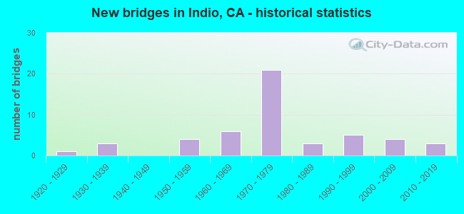
- New bridges - historical statistics
- 11920-1929
- 31930-1939
- 41950-1959
- 61960-1969
- 211970-1979
- 31980-1989
- 51990-1999
- 42000-2009
- 32010-2019
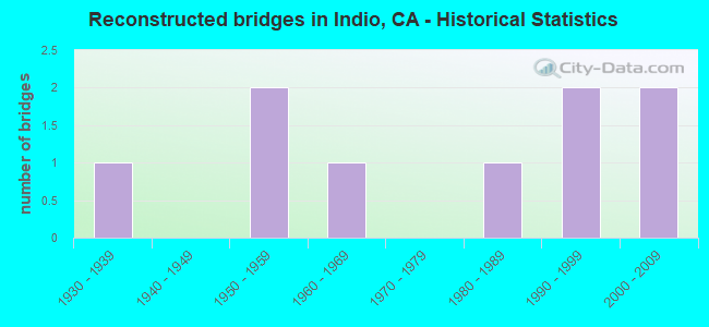
- Reconstructed bridges - Historical Statistics
- 11930-1939
- 01940-1949
- 21950-1959
- 11960-1969
- 01970-1979
- 11980-1989
- 21990-1999
- 22000-2009
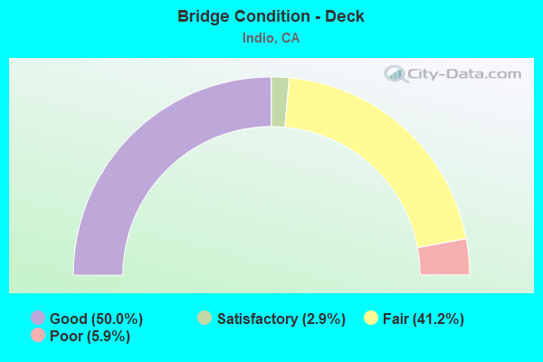
- Bridge Condition - Deck
- 50.0%Good
- 2.9%Satisfactory
- 41.2%Fair
- 5.9%Poor
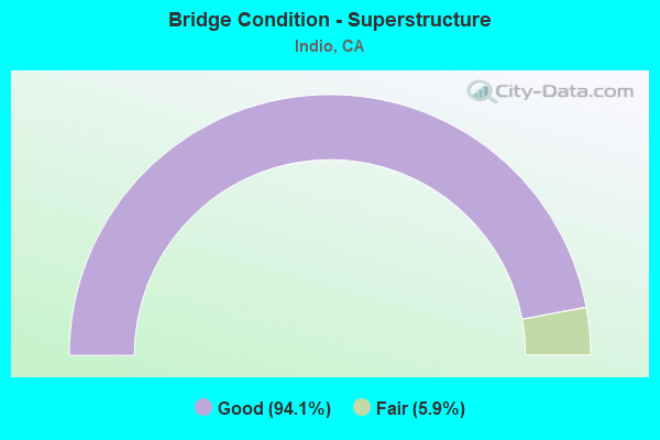
- Bridge Condition - Superstructure
- 94.1%Good
- 5.9%Fair
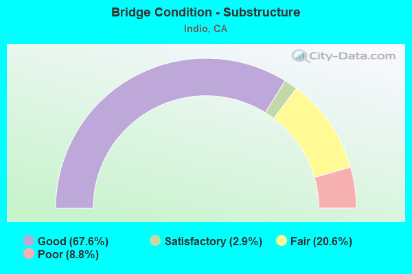
- Bridge Condition - Substructure
- 67.6%Good
- 2.9%Satisfactory
- 20.6%Fair
- 8.8%Poor
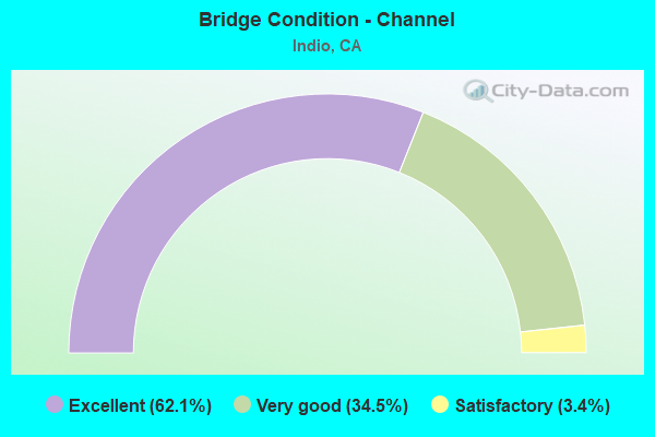
- Bridge Condition - Channel
- 62.1%Excellent
- 34.5%Very good
- 3.4%Satisfactory
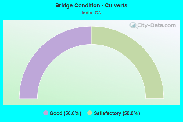
- Bridge Condition - Culverts
- 50.0%Good
- 50.0%Satisfactory
Find on map >> Show street view
Structure Number: 56 0610R, Location: 08-RIV-010-R53.80-IND (Lat: 33.738925, Lng: -116.249814), Route carried "on" structure: Interstate 10, Year Built: 1972, Status: Open, Structure Length: 22.34m (73.29ft), Average Daily Traffic: 33,000 (year 2014), Truck Traffic: 33%, Average Future Daily Traffic: 45,000 (year 2040), Design Load: HS 20, Features Intersected: THOUSAND PALMS WASH
Minimum Vertical Clearance: 30+ m (98+ ft), Kilometerpoint: 53.800, Lanes on structure: 3, Base Highway Network: Yes (, Subroute: 1), Owner: State Highway Agency, Approaching Roadway Width: 15.6m (51.2ft), Skew: 5 degrees, Material/Design: Concrete continuous, Design/Construction: Tee Beam, Number Of Spans In Main Unit: 11, Length of Maximum Span: 21.0m (68.9ft), Curb-To-Curb Width: 15.6m (51.2ft), Out-to-Out Width: 16.4m (53.8ft)
Condition: Deck: Poor, Superstructure: Good, Substructure: Good, Channel: Very good, Operating Rating: 99.8 metric tons, Method Used To Determine Operating Rating: Load Factor (LF), Inventory Rating: 61.9 metric tons, Method Used To Determine Inventory Rating: Load Factor (LF), Structural Evaluation: Better than present minimum criteria, Deck Geometry: Somewhat better than minimum adequacy, Waterway Adequacy: Somewhat better than minimum adequacy, Approach Roadway Alignment: Equal to present desirable criteria, Designated Inspection Frequency: Every 24 months, Inspection Date: October 2021, Deck Structure Type: Concrete Cast-file-Place
Find on map >> Show street view
Structure Number: 56 0611, Location: 08-RIV-010-R54.74-IND (Lat: 33.739786, Lng: -116.233986), Route carried "on" structure: County highway Z858, Year Built: 1972, Status: Open, Structure Length: 7.59m (24.90ft), Average Daily Traffic: 11,660 (year 2014), Truck Traffic: 14%, Average Future Daily Traffic: 23,464 (year 2040), Design Load: HS 20, Features Intersected: INTERSTATE 10, Facility Carried by Structure: MONROE ST
Minimum Vertical Clearance: 30+ m (98+ ft), Kilometerpoint: 0.000, Lanes on structure: 3, Lanes under structure: 6, Owner: State Highway Agency, Approaching Roadway Width: 12.2m (40.0ft), Material/Design: Prestressed concrete continuous, Design/Construction: Box Beam or Girders - Multiple, Number Of Spans In Main Unit: 2, Length of Maximum Span: 39.0m (128.0ft), Curb or Sidewalk Widths: Left: 1.5m (4.9ft), Right: 0.0m, Curb-To-Curb Width: 12.2m (40.0ft), Out-to-Out Width: 14.3m (46.9ft)
Condition: Deck: Good, Superstructure: Good, Substructure: Good, Operating Rating: 59.9 metric tons, Method Used To Determine Operating Rating: Load and Resistance Factor Rating (LRFR) rating reported by rating factor(RF) method using HL-93 loadings, Inventory Rating: 43.1 metric tons, Method Used To Determine Inventory Rating: Load and Resistance Factor Rating (LRFR) rating reported by rating factor(RF) method using HL-93 loadings, Structural Evaluation: Better than present minimum criteria, Deck Geometry: Meets minimum limits, Underclear: Equal to present minimum criteria, Approach Roadway Alignment: Equal to present desirable criteria, Designated Inspection Frequency: Every 24 months, Inspection Date: October 2021, Deck Structure Type: Concrete Cast-file-Place
Find on map >> Show street view
Structure Number: 56 0612, Location: 08-RIV-010-R55.74-IND (Lat: 33.738275, Lng: -116.216639), Route carried "on" structure: County highway Z860, Year Built: 1972, Status: Open, Structure Length: 8.05m (26.41ft), Average Daily Traffic: 10,400 (year 2014), Truck Traffic: 14%, Average Future Daily Traffic: 12,242 (year 2040), Design Load: HS 20, Features Intersected: INTERSTATE 10, Facility Carried by Structure: JACKSON ST
Minimum Vertical Clearance: 30+ m (98+ ft), Kilometerpoint: 0.000, Lanes on structure: 2, Lanes under structure: 6, Owner: State Highway Agency, Approaching Roadway Width: 12.2m (40.0ft), Skew: 2 degrees, Material/Design: Prestressed concrete continuous, Design/Construction: Box Beam or Girders - Multiple, Number Of Spans In Main Unit: 2, Length of Maximum Span: 41.1m (134.8ft), Curb or Sidewalk Widths: Left: 1.5m (4.9ft), Right: 0.0m, Curb-To-Curb Width: 12.2m (40.0ft), Out-to-Out Width: 14.3m (46.9ft)
Condition: Deck: Good, Superstructure: Good, Substructure: Good, Operating Rating: 58.3 metric tons, Method Used To Determine Operating Rating: Load and Resistance Factor Rating (LRFR) rating reported by rating factor(RF) method using HL-93 loadings, Inventory Rating: 42.8 metric tons, Method Used To Determine Inventory Rating: Load and Resistance Factor Rating (LRFR) rating reported by rating factor(RF) method using HL-93 loadings, Structural Evaluation: Better than present minimum criteria, Deck Geometry: Somewhat better than minimum adequacy, Underclear: Equal to present minimum criteria, Approach Roadway Alignment: Equal to present desirable criteria, Designated Inspection Frequency: Every 24 months, Inspection Date: October 2021, Deck Structure Type: Concrete Cast-file-Place
Find on map >> Show street view
Structure Number: 56 0613L, Location: 08-RIV-010-R56.57-IND (Lat: 33.729603, Lng: -116.206231), Route carried "on" structure: Interstate 10, Year Built: 1972, Status: Open, Structure Length: 5.51m (18.08ft), Average Daily Traffic: 28,500 (year 2014), Truck Traffic: 32%, Average Future Daily Traffic: 49,988 (year 2040), Design Load: HS 20, Features Intersected: 44TH AVENUE
Minimum Vertical Clearance: 30+ m (98+ ft), Kilometerpoint: 56.570, Lanes on structure: 3, Lanes under structure: 2, Base Highway Network: Yes (, Subroute: 1), Owner: State Highway Agency, Approaching Roadway Width: 15.5m (50.9ft), Skew: 4 degrees, Material/Design: Prestressed concrete, Design/Construction: Box Beam or Girders - Multiple, Number Of Spans In Main Unit: 1, Length of Maximum Span: 53.9m (176.8ft), Curb-To-Curb Width: 15.5m (50.9ft), Out-to-Out Width: 16.2m (53.1ft)
Condition: Deck: Good, Superstructure: Good, Substructure: Fair, Operating Rating: 65.8 metric tons, Method Used To Determine Operating Rating: Load and Resistance Factor Rating (LRFR) rating reported by rating factor(RF) method using HL-93 loadings, Inventory Rating: 37.9 metric tons, Method Used To Determine Inventory Rating: Load and Resistance Factor Rating (LRFR) rating reported by rating factor(RF) method using HL-93 loadings, Structural Evaluation: Somewhat better than minimum adequacy, Deck Geometry: Somewhat better than minimum adequacy, Underclear: Equal to present minimum criteria, Approach Roadway Alignment: Equal to present desirable criteria, Designated Inspection Frequency: Every 24 months, Inspection Date: October 2021, Deck Structure Type: Concrete Cast-file-Place
Find on map >> Show street view
Structure Number: 56 0613R, Location: 08-RIV-010-R56.57-IND (Lat: 33.729603, Lng: -116.206753), Route carried "on" structure: Interstate 10, Year Built: 1972, Status: Open, Structure Length: 5.46m (17.91ft), Average Daily Traffic: 28,500 (year 2014), Truck Traffic: 32%, Average Future Daily Traffic: 49,988 (year 2040), Design Load: HS 20, Features Intersected: 44TH AVENUE
Minimum Vertical Clearance: 30+ m (98+ ft), Kilometerpoint: 56.570, Lanes on structure: 3, Lanes under structure: 2, Base Highway Network: Yes (, Subroute: 1), Owner: State Highway Agency, Approaching Roadway Width: 15.6m (51.2ft), Skew: 4 degrees, Material/Design: Prestressed concrete, Design/Construction: Box Beam or Girders - Multiple, Number Of Spans In Main Unit: 1, Length of Maximum Span: 53.9m (176.8ft), Curb-To-Curb Width: 15.6m (51.2ft), Out-to-Out Width: 16.2m (53.1ft)
Condition: Deck: Good, Superstructure: Good, Substructure: Fair, Operating Rating: 63.5 metric tons, Method Used To Determine Operating Rating: Load and Resistance Factor Rating (LRFR) rating reported by rating factor(RF) method using HL-93 loadings, Inventory Rating: 35.6 metric tons, Method Used To Determine Inventory Rating: Load and Resistance Factor Rating (LRFR) rating reported by rating factor(RF) method using HL-93 loadings, Structural Evaluation: Somewhat better than minimum adequacy, Deck Geometry: Somewhat better than minimum adequacy, Underclear: Somewhat better than minimum adequacy, Approach Roadway Alignment: Equal to present desirable criteria, Designated Inspection Frequency: Every 24 months, Inspection Date: October 2021, Deck Structure Type: Concrete Cast-file-Place
Find on map >> Show street view
Structure Number: 56 0614, Location: 08-RIV-010-R56.95-IND (Lat: 33.726364, Lng: -116.201311), Route carried "on" structure: City street , Year Built: 1972, Status: Open, Structure Length: 7.80m (25.59ft), Average Daily Traffic: 55,000 (year 2014), Truck Traffic: 10%, Average Future Daily Traffic: 65,000 (year 2040), Design Load: HS 20, Features Intersected: INTERSTATE 10, Facility Carried by Structure: GOLF CENTER PKWY
Minimum Vertical Clearance: 30+ m (98+ ft), Kilometerpoint: 0.000, Lanes on structure: 4, Lanes under structure: 6, Owner: State Highway Agency, Approaching Roadway Width: 26.2m (86.0ft), Material/Design: Prestressed concrete continuous, Design/Construction: Box Beam or Girders - Multiple, Number Of Spans In Main Unit: 2, Length of Maximum Span: 39.0m (128.0ft), Curb or Sidewalk Widths: Left: 0.0m, Right: 1.5m (4.9ft), Curb-To-Curb Width: 26.2m (86.0ft), Out-to-Out Width: 28.4m (93.2ft)
Condition: Deck: Fair, Superstructure: Good, Substructure: Good, Operating Rating: 53.8 metric tons, Method Used To Determine Operating Rating: Load and Resistance Factor Rating (LRFR) rating reported by rating factor(RF) method using HL-93 loadings, Inventory Rating: 36.3 metric tons, Method Used To Determine Inventory Rating: Load and Resistance Factor Rating (LRFR) rating reported by rating factor(RF) method using HL-93 loadings, Structural Evaluation: Better than present minimum criteria, Deck Geometry: Superior to present desirable criteria, Underclear: Better than present minimum criteria, Approach Roadway Alignment: Equal to present desirable criteria, Designated Inspection Frequency: Every 24 months, Inspection Date: October 2021, Deck Structure Type: Concrete Cast-file-Place
Find on map >> Show street view
Structure Number: 56 0620G, Location: 08-RIV-086-R22.94-IND (Lat: 33.715981, Lng: -116.190458), Route carried "on" structure: State highway 86, Year Built: 1972, Status: Open, Structure Length: 15.12m (49.61ft), Average Daily Traffic: 27,400 (year 2012), Truck Traffic: 30%, Average Future Daily Traffic: 49,405 (year 2038), Design Load: HS 20+Mod, Features Intersected: INTERSTATE 10 EB
Minimum Vertical Clearance: 30+ m (98+ ft), Kilometerpoint: 22.940, Lanes on structure: 2, Lanes under structure: 2, Base Highway Network: Yes, Owner: State Highway Agency, Approaching Roadway Width: 11.9m (39.0ft), Skew: 9 degrees, Material/Design: Prestressed concrete continuous, Design/Construction: Box Beam or Girders - Multiple, Number Of Spans In Main Unit: 3, Number Of Approach Spans: 2, Length of Maximum Span: 61.9m (203.1ft), Curb-To-Curb Width: 11.9m (39.0ft), Out-to-Out Width: 12.9m (42.3ft)
Condition: Deck: Fair, Superstructure: Good, Substructure: Good, Operating Rating: 92.0 metric tons, Method Used To Determine Operating Rating: Load and Resistance Factor Rating (LRFR) rating reported by rating factor(RF) method using HL-93 loadings, Inventory Rating: 57.0 metric tons, Method Used To Determine Inventory Rating: Load and Resistance Factor Rating (LRFR) rating reported by rating factor(RF) method using HL-93 loadings, Structural Evaluation: Better than present minimum criteria, Deck Geometry: Equal to present minimum criteria, Underclear: Somewhat better than minimum adequacy, Approach Roadway Alignment: Equal to present desirable criteria, Designated Inspection Frequency: Every 24 months, Inspection Date: April 2021, Deck Structure Type: Concrete Cast-file-Place
Find on map >> Show street view
Structure Number: 56C0081, Location: 0.2 MI S/O OAK VALLEY PWY (Lat: 33.942489, Lng: -117.001500), Route carried "on" structure: City street , Year Built: 1939, Status: Open, Structure Length: 3.08m (10.10ft), Average Daily Traffic: 50 (year 2019), Truck Traffic: 10%, Average Future Daily Traffic: 51 (year 2041), Design Load: H 15, Features Intersected: MID FK SAN TIMOTEO CREEK, Facility Carried by Structure: DESERT LAWN DRIVE
Minimum Vertical Clearance: 30+ m (98+ ft), Kilometerpoint: 0.000, Lanes on structure: 2, Owner: City or Municipal Highway Agency, Approaching Roadway Width: 8.8m (28.9ft), Skew: 2 degrees, Material/Design: Concrete continuous, Design/Construction: Slab, Number Of Spans In Main Unit: 5, Length of Maximum Span: 6.7m (22.0ft), Curb or Sidewalk Widths: Left: 0.9m (3.0ft), Right: 0.9m (3.0ft), Curb-To-Curb Width: 7.7m (25.3ft), Out-to-Out Width: 9.5m (31.2ft)
Condition: Deck: Good, Superstructure: Good, Substructure: Good, Channel: Excellent, Operating Rating: 39.9 metric tons, Method Used To Determine Operating Rating: Load Factor (LF), Inventory Rating: 24.0 metric tons, Method Used To Determine Inventory Rating: Load Factor (LF), Structural Evaluation: Equal to present minimum criteria, Deck Geometry: Equal to present minimum criteria, Waterway Adequacy: Superior to present desirable criteria, Approach Roadway Alignment: Equal to present desirable criteria, Designated Inspection Frequency: Every 24 months, Inspection Date: July 2021, Deck Structure Type: Concrete Cast-file-Place, Wearing Surface/Protective System: Wearing Surface: Bituminous
Find on map >> Show street view
Structure Number: 56C0083, Location: 0.1 MI. S/O RTE. I-10 FWY (Lat: 33.736850, Lng: -116.233681), Route carried "on" structure: City street , Year Built: 1972, Status: Open, Structure Length: 14.94m (49.02ft), Average Daily Traffic: 22,400 (year 2017), Truck Traffic: 1%, Average Future Daily Traffic: 17,563 (year 2043), Design Load: HS 20, Features Intersected: WHITEWATER RIVER, Facility Carried by Structure: MONROE STREET
Minimum Vertical Clearance: 30+ m (98+ ft), Kilometerpoint: 0.000, Lanes on structure: 2, Owner: City or Municipal Highway Agency, Approaching Roadway Width: 12.2m (40.0ft), Material/Design: Concrete continuous, Design/Construction: Box Beam or Girders - Multiple, Number Of Spans In Main Unit: 5, Length of Maximum Span: 33.5m (109.9ft), Curb or Sidewalk Widths: Left: 1.5m (4.9ft), Right: 0.0m, Curb-To-Curb Width: 12.2m (40.0ft), Out-to-Out Width: 14.3m (46.9ft)
Condition: Deck: Poor, Superstructure: Good, Substructure: Fair, Channel: Very good, Operating Rating: 99.8 metric tons, Method Used To Determine Operating Rating: Load Factor (LF), Inventory Rating: 69.3 metric tons, Method Used To Determine Inventory Rating: Load Factor (LF), Structural Evaluation: Somewhat better than minimum adequacy, Deck Geometry: Somewhat better than minimum adequacy, Waterway Adequacy: Equal to present desirable criteria, Approach Roadway Alignment: Equal to present desirable criteria, Length Of Structure Improvement: 14.94m (49.02ft), Designated Inspection Frequency: Every 24 months, Inspection Date: October 2021, Bridge Improvement Cost: $2,139,000, Roadway Improvement Cost: $427,000, Total Project Cost: $3,593,000 ( Estimate for 2019), Deck Structure Type: Concrete Cast-file-Place
Find on map >> Show street view
Structure Number: 56C0084, Location: 0.2 MI. S/O RTE. I-10 FWY (Lat: 33.735256, Lng: -116.216406), Route carried "on" structure: City street , Year Built: 1972, Status: Open, Structure Length: 16.82m (55.18ft), Average Daily Traffic: 17,000 (year 2017), Truck Traffic: 1%, Average Future Daily Traffic: 13,172 (year 2043), Design Load: HS 20, Features Intersected: WHITEWATER RIVER, Facility Carried by Structure: JACKSON STREET
Minimum Vertical Clearance: 30+ m (98+ ft), Kilometerpoint: 0.000, Lanes on structure: 2, Owner: City or Municipal Highway Agency, Approaching Roadway Width: 20.0m (65.6ft), Skew: 2 degrees, Material/Design: Concrete continuous, Design/Construction: Box Beam or Girders - Multiple, Number Of Spans In Main Unit: 5, Length of Maximum Span: 33.5m (109.9ft), Curb or Sidewalk Widths: Left: 1.5m (4.9ft), Right: 0.0m, Curb-To-Curb Width: 12.2m (40.0ft), Out-to-Out Width: 14.3m (46.9ft)
Condition: Deck: Fair, Superstructure: Good, Substructure: Good, Channel: Very good, Operating Rating: 89.7 metric tons, Method Used To Determine Operating Rating: Load Factor (LF), Inventory Rating: 53.8 metric tons, Method Used To Determine Inventory Rating: Load Factor (LF), Structural Evaluation: Better than present minimum criteria, Deck Geometry: Somewhat better than minimum adequacy, Waterway Adequacy: Equal to present desirable criteria, Approach Roadway Alignment: Equal to present desirable criteria, Designated Inspection Frequency: Every 24 months, Inspection Date: October 2021, Deck Structure Type: Concrete Cast-file-Place
Find on map >> Show street view
Structure Number: 56C012, Location: 0.8 MI E/O EAGLE MTN ROAD (Lat: 33.705489, Lng: -115.438728), Route carried "on" structure: County highway , Year Built: 1932, Year Reconstructed: 1944, Status: Open, Structure Length: 1.83m (6.00ft), Average Daily Traffic: 200 (year 2018), Truck Traffic: 5%, Average Future Daily Traffic: 250 (year 2038), Features Intersected: BUENA DITCH, Facility Carried by Structure: RAGSDALE ROAD
Minimum Vertical Clearance: 30+ m (98+ ft), Kilometerpoint: 0.000, Lanes on structure: 2, Owner: County Highway Agency, Approaching Roadway Width: 6.7m (22.0ft), Material/Design: Wood or Timber, Design/Construction: Stringer/Multi-beam, Number Of Spans In Main Unit: 3, Length of Maximum Span: 5.8m (19.0ft), Curb-To-Curb Width: 7.3m (24.0ft), Out-to-Out Width: 7.9m (25.9ft)
Condition: Deck: Good, Superstructure: Good, Substructure: Good, Channel: Very good, Operating Rating: 35.3 metric tons, Method Used To Determine Operating Rating: Allowable Stress (AS), Inventory Rating: 24.9 metric tons, Method Used To Determine Inventory Rating: Allowable Stress (AS), Structural Evaluation: Equal to present minimum criteria, Deck Geometry: Somewhat better than minimum adequacy, Waterway Adequacy: Superior to present desirable criteria, Approach Roadway Alignment: Equal to present desirable criteria, Designated Inspection Frequency: Every 24 months, Inspection Date: June 2021, Deck Structure Type: Concrete Cast-file-Place, Wearing Surface/Protective System: Wearing Surface: Bituminous
Find on map >> Show street view
Structure Number: 56C0128, Location: 50' W/O HJORTH ST (Lat: 33.692617, Lng: -116.247308), Route carried "on" structure: City street , Year Built: 1989, Status: Open, Structure Length: 1.34m (4.40ft), Average Daily Traffic: 900 (year 2011), Truck Traffic: 1%, Average Future Daily Traffic: 887 (year 2043), Design Load: HS 20+Mod, Features Intersected: COACHELLA CANAL, Facility Carried by Structure: 49TH AVENUE
Minimum Vertical Clearance: 30+ m (98+ ft), Kilometerpoint: 0.000, Lanes on structure: 2, Owner: City or Municipal Highway Agency, Approaching Roadway Width: 7.0m (23.0ft), Material/Design: Prestressed concrete, Design/Construction: Slab, Number Of Spans In Main Unit: 1, Length of Maximum Span: 12.8m (42.0ft), Curb or Sidewalk Widths: Left: 0.0m, Right: 1.5m (4.9ft), Curb-To-Curb Width: 14.0m (45.9ft), Out-to-Out Width: 16.5m (54.1ft)
Condition: Deck: Good, Superstructure: Good, Substructure: Good, Channel: Excellent, Operating Rating: 54.1 metric tons, Method Used To Determine Operating Rating: Assigned rating based on Load Factor Design (LFD) reported in metric tons, Inventory Rating: 32.4 metric tons, Method Used To Determine Inventory Rating: Assigned rating based on Load Factor Design (LFD) reported in metric tons, Structural Evaluation: Better than present minimum criteria, Deck Geometry: Superior to present desirable criteria, Waterway Adequacy: Equal to present desirable criteria, Approach Roadway Alignment: Equal to present desirable criteria, Designated Inspection Frequency: Every 48 months, Inspection Date: October 2021, Deck Structure Type: Concrete Precast Panels, Wearing Surface/Protective System: Wearing Surface: Bituminous
Find on map >> Show street view
Structure Number: 56C014, Location: 100' E/O BAIN STREET (Lat: 33.992656, Lng: -117.505600), Route carried "on" structure: County highway , Year Built: 1971, Status: Open, Structure Length: 3.41m (11.19ft), Average Daily Traffic: 6,636 (year 2011), Truck Traffic: 1%, Average Future Daily Traffic: 15,000 (year 2038), Design Load: HS 20, Features Intersected: SAN SEVAINE CHANNEL, Facility Carried by Structure: JURUPA ROAD
Minimum Vertical Clearance: 30+ m (98+ ft), Kilometerpoint: 0.000, Lanes on structure: 2, Owner: County Highway Agency, Approaching Roadway Width: 7.3m (24.0ft), Material/Design: Concrete continuous, Design/Construction: Tee Beam, Number Of Spans In Main Unit: 3, Length of Maximum Span: 13.4m (44.0ft), Curb or Sidewalk Widths: Left: 1.5m (4.9ft), Right: 0.0m, Curb-To-Curb Width: 12.2m (40.0ft), Out-to-Out Width: 14.0m (45.9ft)
Condition: Deck: Fair, Superstructure: Good, Substructure: Good, Channel: Excellent, Operating Rating: 62.2 metric tons, Method Used To Determine Operating Rating: Load and Resistance Factor Rating (LRFR) rating reported by rating factor(RF) method using HL-93 loadings, Inventory Rating: 48.0 metric tons, Method Used To Determine Inventory Rating: Load and Resistance Factor Rating (LRFR) rating reported by rating factor(RF) method using HL-93 loadings, Structural Evaluation: Better than present minimum criteria, Deck Geometry: Somewhat better than minimum adequacy, Waterway Adequacy: Superior to present desirable criteria, Approach Roadway Alignment: Equal to present desirable criteria, Designated Inspection Frequency: Every 24 months, Inspection Date: March 2020, Deck Structure Type: Concrete Cast-file-Place
Find on map >> Show street view
Structure Number: 56C0149, Location: 50' E/O MADISON STREET (Lat: 33.721883, Lng: -116.251283), Route carried "on" structure: City street , Year Built: 1994, Status: Open, Structure Length: 1.43m (4.69ft), Average Daily Traffic: 10,800 (year 2017), Truck Traffic: 1%, Average Future Daily Traffic: 13,849 (year 2041), Features Intersected: COACHELLA CANAL, Facility Carried by Structure: MILES AVENUE
Minimum Vertical Clearance: 30+ m (98+ ft), Kilometerpoint: 0.000, Lanes on structure: 4, Owner: City or Municipal Highway Agency, Approaching Roadway Width: 14.9m (48.9ft), Material/Design: Prestressed concrete, Design/Construction: Slab, Number Of Spans In Main Unit: 1, Length of Maximum Span: 14.3m (46.9ft), Curb or Sidewalk Widths: Left: 1.5m (4.9ft), Right: 1.5m (4.9ft), Curb-To-Curb Width: 18.2m (59.7ft), Out-to-Out Width: 21.9m (71.9ft)
Condition: Deck: Fair, Superstructure: Fair, Substructure: Good, Channel: Excellent, Operating Rating: 54.1 metric tons, Method Used To Determine Operating Rating: Field evaluation and documented engineering judgment, Inventory Rating: 32.4 metric tons, Method Used To Determine Inventory Rating: Field evaluation and documented engineering judgment, Structural Evaluation: Somewhat better than minimum adequacy, Deck Geometry: Somewhat better than minimum adequacy, Waterway Adequacy: Equal to present desirable criteria, Approach Roadway Alignment: Equal to present desirable criteria, Designated Inspection Frequency: Every 24 months, Inspection Date: October 2021, Deck Structure Type: Concrete Precast Panels
Find on map >> Show street view
Structure Number: 56C0161, Location: 1.0 MI. W/O LAKEVIEW AVE (Lat: 33.841542, Lng: -117.140167), Route carried "on" structure: County highway , Year Built: 1959, Status: Open, Structure Length: 0.64m (2.10ft), Average Daily Traffic: 19,375 (year 2016), Truck Traffic: 2%, Average Future Daily Traffic: 22,656 (year 2037), Features Intersected: PERRIS WASH, Facility Carried by Structure: RAMONA EXPWY
Minimum Vertical Clearance: 30+ m (98+ ft), Kilometerpoint: 0.000, Lanes on structure: 2, Owner: County Highway Agency, Approaching Roadway Width: 12.2m (40.0ft), Material/Design: Concrete, Design/Construction: Culvert, Number Of Spans In Main Unit: 2, Length of Maximum Span: 3.0m (9.8ft), Curb-To-Curb Width: 12.2m (40.0ft), Out-to-Out Width: 16.2m (53.1ft)
Condition: Channel: Excellent, Culverts: Satisfactory, Operating Rating: 40.5 metric tons, Method Used To Determine Operating Rating: Field evaluation and documented engineering judgment, Inventory Rating: 24.3 metric tons, Method Used To Determine Inventory Rating: Field evaluation and documented engineering judgment, Structural Evaluation: Equal to present minimum criteria, Deck Geometry: Somewhat better than minimum adequacy, Waterway Adequacy: Superior to present desirable criteria, Approach Roadway Alignment: Equal to present desirable criteria, Designated Inspection Frequency: Every 24 months, Inspection Date: June 2020
Find on map >> Show street view
Structure Number: 56C0168, Location: 0.2 MI. W/O MADISON ST (Lat: 33.729158, Lng: -116.255125), Route carried "on" structure: City street , Year Built: 1966, Year Reconstructed: 1996, Status: Open, Structure Length: 1.62m (5.31ft), Average Daily Traffic: 21,200 (year 2017), Truck Traffic: 1%, Average Future Daily Traffic: 8,846 (year 2043), Features Intersected: COACHELLA CANAL, Facility Carried by Structure: FRED WARING DRIVE
Minimum Vertical Clearance: 30+ m (98+ ft), Kilometerpoint: 0.000, Lanes on structure: 7, Owner: City or Municipal Highway Agency, Approaching Roadway Width: 26.8m (87.9ft), Skew: 1 degrees, Material/Design: Prestressed concrete, Design/Construction: Stringer/Multi-beam, Number Of Spans In Main Unit: 1, Length of Maximum Span: 15.7m (51.5ft), Curb or Sidewalk Widths: Left: 1.2m (3.9ft), Right: 1.2m (3.9ft), Curb-To-Curb Width: 26.8m (87.9ft), Out-to-Out Width: 29.9m (98.1ft)
Condition: Deck: Fair, Superstructure: Good, Substructure: Good, Channel: Excellent, Operating Rating: 41.1 metric tons, Method Used To Determine Operating Rating: Load and Resistance Factor Rating (LRFR) rating reported by rating factor(RF) method using HL-93 loadings, Inventory Rating: 28.2 metric tons, Method Used To Determine Inventory Rating: Load and Resistance Factor Rating (LRFR) rating reported by rating factor(RF) method using HL-93 loadings, Structural Evaluation: Better than present minimum criteria, Deck Geometry: Somewhat better than minimum adequacy, Waterway Adequacy: Equal to present desirable criteria, Approach Roadway Alignment: Equal to present desirable criteria, Designated Inspection Frequency: Every 24 months, Inspection Date: October 2021, Deck Structure Type: Concrete Cast-file-Place
Find on map >> Show street view
Structure Number: 56C0184, Location: 0.12 MI. W/O MADISON ST. (Lat: 33.743861, Lng: -116.253678), Route carried "on" structure: City street , Year Built: 1972, Status: Open, Structure Length: 1.74m (5.71ft), Average Daily Traffic: 2,900 (year 2011), Truck Traffic: 1%, Average Future Daily Traffic: 1,249 (year 2043), Design Load: HS 20, Features Intersected: COACHELLA CANAL, Facility Carried by Structure: AVENUE 42
Minimum Vertical Clearance: 30+ m (98+ ft), Kilometerpoint: 0.000, Lanes on structure: 2, Owner: City or Municipal Highway Agency, Approaching Roadway Width: 7.3m (24.0ft), Skew: 1 degrees, Material/Design: Prestressed concrete, Design/Construction: Stringer/Multi-beam, Number Of Spans In Main Unit: 1, Length of Maximum Span: 17.1m (56.1ft), Curb-To-Curb Width: 9.4m (30.8ft), Out-to-Out Width: 10.1m (33.1ft)
Condition: Deck: Fair, Superstructure: Good, Substructure: Good, Channel: Excellent, Operating Rating: 37.9 metric tons, Method Used To Determine Operating Rating: Load and Resistance Factor Rating (LRFR) rating reported by rating factor(RF) method using HL-93 loadings, Inventory Rating: 21.4 metric tons, Method Used To Determine Inventory Rating: Load and Resistance Factor Rating (LRFR) rating reported by rating factor(RF) method using HL-93 loadings, Structural Evaluation: Somewhat better than minimum adequacy, Deck Geometry: Meets minimum limits, Waterway Adequacy: Equal to present desirable criteria, Approach Roadway Alignment: Equal to present desirable criteria, Designated Inspection Frequency: Every 24 months, Inspection Date: October 2021, Deck Structure Type: Concrete Cast-file-Place
Find on map >> Show street view
Structure Number: 56C0198, Location: 200' SOUTH OF ST RTE 111 (Lat: 33.706503, Lng: -116.268514), Route carried "on" structure: City street , Year Built: 1981, Year Reconstructed: 2001, Status: Open, Structure Length: 5.30m (17.39ft), Average Daily Traffic: 26,900 (year 2017), Truck Traffic: 1%, Average Future Daily Traffic: 26,632 (year 2043), Design Load: HS 20+Mod, Features Intersected: LA QUINTA CHANNEL, Facility Carried by Structure: JEFFERSON STREET
Minimum Vertical Clearance: 30+ m (98+ ft), Kilometerpoint: 0.000, Lanes on structure: 8, Owner: City or Municipal Highway Agency, Approaching Roadway Width: 21.4m (70.2ft), Skew: 25 degrees, Material/Design: Concrete continuous, Design/Construction: Slab, Number Of Spans In Main Unit: 6, Length of Maximum Span: 9.4m (30.8ft), Curb or Sidewalk Widths: Left: 1.5m (4.9ft), Right: 1.5m (4.9ft), Curb-To-Curb Width: 21.4m (70.2ft), Out-to-Out Width: 39.9m (130.9ft)
Condition: Deck: Good, Superstructure: Good, Substructure: Good, Channel: Very good, Operating Rating: 54.1 metric tons, Method Used To Determine Operating Rating: Assigned rating based on Load Factor Design (LFD) reported in metric tons, Inventory Rating: 32.4 metric tons, Method Used To Determine Inventory Rating: Assigned rating based on Load Factor Design (LFD) reported in metric tons, Structural Evaluation: Better than present minimum criteria, Deck Geometry: High priority of replacement, Waterway Adequacy: Equal to present desirable criteria, Approach Roadway Alignment: Equal to present desirable criteria, Designated Inspection Frequency: Every 48 months, Inspection Date: October 2021, Deck Structure Type: Concrete Cast-file-Place
Find on map >> Show street view
Structure Number: 56C0217, Location: 1 MI E/O GOLF CENTER DR. (Lat: 33.729467, Lng: -116.180911), Route carried "on" structure: City street , Year Built: 1970, Status: Open, Structure Length: 1.52m (4.99ft), Average Daily Traffic: 1,400 (year 2017), Truck Traffic: 3%, Average Future Daily Traffic: 880 (year 2043), Design Load: HS 20, Features Intersected: COACHELLA CANAL WSTWAY 3, Facility Carried by Structure: AVENUE 44
Minimum Vertical Clearance: 30+ m (98+ ft), Kilometerpoint: 0.000, Lanes on structure: 2, Owner: City or Municipal Highway Agency, Approaching Roadway Width: 7.6m (24.9ft), Skew: 4 degrees, Material/Design: Prestressed concrete, Design/Construction: Stringer/Multi-beam, Number Of Spans In Main Unit: 1, Length of Maximum Span: 14.6m (47.9ft), Curb-To-Curb Width: 12.3m (40.4ft), Out-to-Out Width: 12.5m (41.0ft)
Condition: Deck: Fair, Superstructure: Good, Substructure: Good, Channel: Excellent, Operating Rating: 38.9 metric tons, Method Used To Determine Operating Rating: Load and Resistance Factor Rating (LRFR) rating reported by rating factor(RF) method using HL-93 loadings, Inventory Rating: 27.9 metric tons, Method Used To Determine Inventory Rating: Load and Resistance Factor Rating (LRFR) rating reported by rating factor(RF) method using HL-93 loadings, Structural Evaluation: Better than present minimum criteria, Deck Geometry: Better than present minimum criteria, Waterway Adequacy: Equal to present desirable criteria, Approach Roadway Alignment: Equal to present desirable criteria, Designated Inspection Frequency: Every 24 months, Inspection Date: October 2021, Deck Structure Type: Concrete Cast-file-Place
Find on map >> Show street view
Structure Number: 56C0246, Location: 50' N/O 40TH AVENUE (Lat: 33.758628, Lng: -116.234108), Route carried "on" structure: City street , Year Built: 1969, Status: Open, Structure Length: 1.52m (4.99ft), Average Daily Traffic: 3,500 (year 2011), Truck Traffic: 5%, Average Future Daily Traffic: 2,203 (year 2043), Features Intersected: ALL AMERICAN CANAL, Facility Carried by Structure: MONROE STREET
Minimum Vertical Clearance: 30+ m (98+ ft), Kilometerpoint: 0.000, Lanes on structure: 2, Owner: City or Municipal Highway Agency, Approaching Roadway Width: 7.3m (24.0ft), Material/Design: Prestressed concrete, Design/Construction: Slab, Number Of Spans In Main Unit: 1, Length of Maximum Span: 14.0m (45.9ft), Curb or Sidewalk Widths: Left: 0.6m (2.0ft), Right: 0.6m (2.0ft), Curb-To-Curb Width: 7.9m (25.9ft), Out-to-Out Width: 9.4m (30.8ft)
Condition: Deck: Good, Superstructure: Good, Substructure: Good, Channel: Excellent, Operating Rating: 29.8 metric tons, Method Used To Determine Operating Rating: Field evaluation and documented engineering judgment, Inventory Rating: 17.8 metric tons, Method Used To Determine Inventory Rating: Field evaluation and documented engineering judgment, Structural Evaluation: Meets minimum limits, Deck Geometry: High priority of corrective action, Waterway Adequacy: Equal to present desirable criteria, Approach Roadway Alignment: Equal to present desirable criteria, Designated Inspection Frequency: Every 24 months, Inspection Date: October 2021, Deck Structure Type: Concrete Precast Panels, Wearing Surface/Protective System: Wearing Surface: Bituminous
Find on map >> Show street view
Structure Number: 56C025, Location: 0.4 MI. S/O RIVER ROAD (Lat: 33.886719, Lng: -117.571392), Route carried "on" structure: City street , Year Built: 1970, Year Reconstructed: 1986, Status: Open, Structure Length: 1.01m (3.31ft), Average Daily Traffic: 1,500 (year 2012), Truck Traffic: 1%, Average Future Daily Traffic: 3,154 (year 2040), Design Load: HS 20, Features Intersected: CORONA STORM DRAIN, Facility Carried by Structure: COTA STREET
Minimum Vertical Clearance: 30+ m (98+ ft), Kilometerpoint: 0.000, Lanes on structure: 3, Owner: City or Municipal Highway Agency, Approaching Roadway Width: 10.4m (34.1ft), Skew: 3 degrees, Material/Design: Concrete, Design/Construction: Culvert, Number Of Spans In Main Unit: 2, Length of Maximum Span: 4.3m (14.1ft), Curb or Sidewalk Widths: Left: 0.0m, Right: 3.4m (11.2ft), Curb-To-Curb Width: 12.6m (41.3ft), Out-to-Out Width: 16.5m (54.1ft)
Condition: Channel: Excellent, Culverts: Satisfactory, Operating Rating: 40.5 metric tons, Method Used To Determine Operating Rating: Field evaluation and documented engineering judgment, Inventory Rating: 24.3 metric tons, Method Used To Determine Inventory Rating: Field evaluation and documented engineering judgment, Structural Evaluation: Equal to present minimum criteria, Deck Geometry: Meets minimum limits, Waterway Adequacy: Equal to present desirable criteria, Approach Roadway Alignment: Equal to present desirable criteria, Designated Inspection Frequency: Every 24 months, Inspection Date: January 2021, Deck Structure Type: Concrete Cast-file-Place, Wearing Surface/Protective System: Wearing Surface: Bituminous
Find on map >> Show street view
Structure Number: 56C0252, Location: 50' W/O HJORTH STREET (Lat: 33.699850, Lng: -116.247239), Route carried "on" structure: City street , Year Built: 1967, Year Reconstructed: 2007, Status: Open, Structure Length: 1.49m (4.89ft), Average Daily Traffic: 16,800 (year 2017), Truck Traffic: 1%, Average Future Daily Traffic: 22,223 (year 2043), Features Intersected: COACHELLA CANAL, Facility Carried by Structure: AVENUE 48
Minimum Vertical Clearance: 30+ m (98+ ft), Kilometerpoint: 0.000, Lanes on structure: 5, Owner: City or Municipal Highway Agency, Approaching Roadway Width: 22.7m (74.5ft), Material/Design: Prestressed concrete, Design/Construction: Stringer/Multi-beam, Number Of Spans In Main Unit: 1, Length of Maximum Span: 14.3m (46.9ft), Curb or Sidewalk Widths: Left: 1.8m (5.9ft), Right: 1.8m (5.9ft), Curb-To-Curb Width: 25.6m (84.0ft), Out-to-Out Width: 29.9m (98.1ft)
Condition: Deck: Good, Superstructure: Good, Substructure: Good, Channel: Excellent, Operating Rating: 30.1 metric tons, Method Used To Determine Operating Rating: Load and Resistance Factor Rating (LRFR) rating reported by rating factor(RF) method using HL-93 loadings, Inventory Rating: 23.3 metric tons, Method Used To Determine Inventory Rating: Load and Resistance Factor Rating (LRFR) rating reported by rating factor(RF) method using HL-93 loadings, Structural Evaluation: Somewhat better than minimum adequacy, Deck Geometry: Superior to present desirable criteria, Waterway Adequacy: Equal to present desirable criteria, Approach Roadway Alignment: Equal to present desirable criteria, Designated Inspection Frequency: Every 24 months, Inspection Date: October 2021, Deck Structure Type: Concrete Cast-file-Place, Wearing Surface/Protective System: Wearing Surface: Bituminous
Find on map >> Show street view
Structure Number: 56C0253, Location: 0.1 MI. E/O MADISON ST (Lat: 33.714600, Lng: -116.249489), Route carried "on" structure: City street , Year Built: 1965, Status: Open, Structure Length: 1.40m (4.59ft), Average Daily Traffic: 1,700 (year 2011), Truck Traffic: 1%, Average Future Daily Traffic: 3,293 (year 2043), Features Intersected: COACHELLA CANAL, Facility Carried by Structure: AVENUE 46
Minimum Vertical Clearance: 30+ m (98+ ft), Kilometerpoint: 0.000, Lanes on structure: 2, Owner: City or Municipal Highway Agency, Approaching Roadway Width: 20.0m (65.6ft), Material/Design: Prestressed concrete, Design/Construction: Stringer/Multi-beam, Number Of Spans In Main Unit: 1, Length of Maximum Span: 13.4m (44.0ft), Curb-To-Curb Width: 12.4m (40.7ft), Out-to-Out Width: 13.4m (44.0ft)
Condition: Deck: Good, Superstructure: Good, Substructure: Good, Channel: Excellent, Operating Rating: 29.8 metric tons, Method Used To Determine Operating Rating: Field evaluation and documented engineering judgment, Inventory Rating: 17.8 metric tons, Method Used To Determine Inventory Rating: Field evaluation and documented engineering judgment, Structural Evaluation: Meets minimum limits, Deck Geometry: Better than present minimum criteria, Waterway Adequacy: Equal to present desirable criteria, Approach Roadway Alignment: Equal to present desirable criteria, Designated Inspection Frequency: Every 24 months, Inspection Date: October 2021, Deck Structure Type: Concrete Cast-file-Place, Wearing Surface/Protective System: Wearing Surface: Integral Concrete
Find on map >> Show street view
Structure Number: 56C0282, Location: 0.3 MI. W/O JEFFERSON ST. (Lat: 33.745628, Lng: -116.265206), Route carried "on" structure: City street , Year Built: 1936, Status: Open, Structure Length: 4.97m (16.31ft), Average Daily Traffic: 16,800 (year 2017), Truck Traffic: 1%, Average Future Daily Traffic: 13,172 (year 2043), Design Load: H 15, Features Intersected: UP RR & AMTRAK, Facility Carried by Structure: N/B INDIO BLVD.
Minimum Vertical Clearance: 30+ m (98+ ft), Kilometerpoint: 0.000, Lanes on structure: 2, Base Highway Network: Yes, Owner: City or Municipal Highway Agency, Approaching Roadway Width: 10.1m (33.1ft), Skew: 5 degrees, Material/Design: Concrete continuous, Design/Construction: Tee Beam, Number Of Spans In Main Unit: 3, Length of Maximum Span: 19.5m (64.0ft), Curb or Sidewalk Widths: Left: 0.4m (1.3ft), Right: 0.4m (1.3ft), Curb-To-Curb Width: 10.1m (33.1ft), Out-to-Out Width: 11.3m (37.1ft)
Condition: Deck: Satisfactory, Superstructure: Fair, Substructure: Good, Operating Rating: 42.8 metric tons, Method Used To Determine Operating Rating: Load and Resistance Factor Rating (LRFR) rating reported by rating factor(RF) method using HL-93 loadings, Inventory Rating: 33.0 metric tons, Method Used To Determine Inventory Rating: Load and Resistance Factor Rating (LRFR) rating reported by rating factor(RF) method using HL-93 loadings, Structural Evaluation: Somewhat better than minimum adequacy, Deck Geometry: Somewhat better than minimum adequacy, Underclear: Meets minimum limits, Approach Roadway Alignment: Equal to present desirable criteria, Designated Inspection Frequency: Every 24 months, Inspection Date: October 2021, Deck Structure Type: Concrete Cast-file-Place, Wearing Surface/Protective System: Wearing Surface: Bituminous
Find on map >> Show street view
Structure Number: 56C0283, Location: 0.3 MI W/O JEFFERSON STR (Lat: 33.745714, Lng: -116.265522), Route carried "on" structure: City street , Year Built: 1956, Status: Open, Structure Length: 10.48m (34.38ft), Average Daily Traffic: 16,800 (year 2021), Truck Traffic: 1%, Average Future Daily Traffic: 18,172 (year 2043), Design Load: HS 20, Features Intersected: UP RR & AMTRAK, Facility Carried by Structure: SB INDIO BLVD
Minimum Vertical Clearance: 30+ m (98+ ft), Kilometerpoint: 0.000, Lanes on structure: 2, Base Highway Network: Yes, Owner: City or Municipal Highway Agency, Approaching Roadway Width: 9.4m (30.8ft), Skew: 5 degrees, Material/Design: Steel, Design/Construction: Stringer/Multi-beam, Number Of Spans In Main Unit: 5, Length of Maximum Span: 23.5m (77.1ft), Curb or Sidewalk Widths: Left: 0.6m (2.0ft), Right: 0.6m (2.0ft), Curb-To-Curb Width: 8.5m (27.9ft), Out-to-Out Width: 10.1m (33.1ft)
Condition: Deck: Good, Superstructure: Good, Substructure: Fair, Operating Rating: 25.9 metric tons, Method Used To Determine Operating Rating: Load Factor (LF), Inventory Rating: 15.6 metric tons, Method Used To Determine Inventory Rating: Load Factor (LF), Structural Evaluation: High priority of corrective action, Deck Geometry: High priority of corrective action, Underclear: Meets minimum limits, Approach Roadway Alignment: Equal to present desirable criteria, Designated Inspection Frequency: Every 24 months, Other Special Inspection Frequency: Every 48 months, Inspection Date: October 2021, Other Special Inspection Date: October 2021, Deck Structure Type: Concrete Cast-file-Place, Wearing Surface/Protective System: Wearing Surface: Bituminous
Find on map >> Show street view
Structure Number: 56C029, Location: 0.9 MI. SE/O VAN BUREN BL (Lat: 33.876367, Lng: -117.397828), Route carried "on" structure: County highway , Year Built: 1975, Status: Open, Structure Length: 5.55m (18.21ft), Average Daily Traffic: 6,225 (year 2009), Truck Traffic: 1%, Average Future Daily Traffic: 12,448 (year 2036), Features Intersected: MOCKINGBIRD CANYON CREEK, Facility Carried by Structure: MOCKINGBIRD CYN RD
Minimum Vertical Clearance: 30+ m (98+ ft), Kilometerpoint: 0.000, Lanes on structure: 2, Owner: County Highway Agency, Approaching Roadway Width: 12.2m (40.0ft), Skew: 7 degrees, Material/Design: Concrete, Design/Construction: Culvert, Number Of Spans In Main Unit: 5, Length of Maximum Span: 10.8m (35.4ft), Curb or Sidewalk Widths: Left: 0.3m (1.0ft), Right: 0.0m, Curb-To-Curb Width: 11.1m (36.4ft), Out-to-Out Width: 13.4m (44.0ft)
Condition: Channel: Satisfactory, Culverts: Satisfactory, Operating Rating: 54.1 metric tons, Method Used To Determine Operating Rating: Field evaluation and documented engineering judgment, Inventory Rating: 32.4 metric tons, Method Used To Determine Inventory Rating: Field evaluation and documented engineering judgment, Structural Evaluation: Equal to present minimum criteria, Deck Geometry: Meets minimum limits, Waterway Adequacy: Equal to present minimum criteria, Approach Roadway Alignment: Equal to present desirable criteria, Designated Inspection Frequency: Every 48 months, Inspection Date: April 2018
Find on map >> Show street view
Structure Number: 56C0291, Location: AT INDIO BOULEVARD (Lat: 33.719994, Lng: -116.216108), Route carried "on" structure: City street , Year Built: 1964, Status: Open, Structure Length: 21.24m (69.69ft), Average Daily Traffic: 20,500 (year 2012), Truck Traffic: 1%, Average Future Daily Traffic: 25,397 (year 2039), Design Load: HS 20+Mod, Features Intersected: INDIO BOULEVARD, Facility Carried by Structure: JACKSON STREET
Minimum Vertical Clearance: 5.99m (19.65ft), Kilometerpoint: 0.000, Lanes on structure: 4, Lanes under structure: 4, Owner: City or Municipal Highway Agency, Approaching Roadway Width: 16.6m (54.5ft), Skew: 20 degrees, Material/Design: Steel, Design/Construction: Stringer/Multi-beam, Number Of Spans In Main Unit: 8, Length of Maximum Span: 29.0m (95.1ft), Curb or Sidewalk Widths: Left: 0.0m, Right: 1.5m (4.9ft), Curb-To-Curb Width: 16.6m (54.5ft), Out-to-Out Width: 19.2m (63.0ft)
Condition: Deck: Fair, Superstructure: Good, Substructure: Fair, Operating Rating: 44.4 metric tons, Method Used To Determine Operating Rating: Load Factor (LF), Inventory Rating: 26.6 metric tons, Method Used To Determine Inventory Rating: Load Factor (LF), Structural Evaluation: Somewhat better than minimum adequacy, Deck Geometry: Somewhat better than minimum adequacy, Underclear: High priority of corrective action, Approach Roadway Alignment: Better than present minimum criteria, Designated Inspection Frequency: Every 24 months, Critical Feature Inspection Frequency: Every 24 months, Inspection Date: January 2021, Critical Feature Inspection Date: May 2020, Deck Structure Type: Concrete Cast-file-Place
Find on map >> Show street view
Structure Number: 56C0292, Location: 0.8 MI. NW/O MONROE ST (Lat: 33.735006, Lng: -116.244161), Route carried "on" structure: City street , Year Built: 1956, Year Reconstructed: 1961, Status: Open, Structure Length: 14.63m (48.00ft), Average Daily Traffic: 9,750 (year 2017), Truck Traffic: 1%, Average Future Daily Traffic: 13,172 (year 2043), Design Load: HS 20, Features Intersected: WHITEWATER RIVER, Facility Carried by Structure: INDIO BLVD WB
Minimum Vertical Clearance: 30+ m (98+ ft), Kilometerpoint: 0.000, Lanes on structure: 2, Owner: City or Municipal Highway Agency, Approaching Roadway Width: 9.8m (32.2ft), Material/Design: Concrete continuous, Design/Construction: Tee Beam, Number Of Spans In Main Unit: 16, Length of Maximum Span: 9.1m (29.9ft), Curb or Sidewalk Widths: Left: 0.6m (2.0ft), Right: 0.6m (2.0ft), Curb-To-Curb Width: 8.5m (27.9ft), Out-to-Out Width: 10.4m (34.1ft)
Condition: Deck: Fair, Superstructure: Good, Substructure: Poor, Channel: Very good, Operating Rating: 28.8 metric tons, Method Used To Determine Operating Rating: Load and Resistance Factor Rating (LRFR) rating reported by rating factor(RF) method using HL-93 loadings, Inventory Rating: 19.8 metric tons, Method Used To Determine Inventory Rating: Load and Resistance Factor Rating (LRFR) rating reported by rating factor(RF) method using HL-93 loadings, Structural Evaluation: Meets minimum limits, Deck Geometry: High priority of corrective action, Waterway Adequacy: Equal to present desirable criteria, Approach Roadway Alignment: Equal to present desirable criteria, Length Of Structure Improvement: 14.63m (48.00ft), Designated Inspection Frequency: Every 24 months, Inspection Date: October 2021, Bridge Improvement Cost: $1,516,000, Roadway Improvement Cost: $303,000, Total Project Cost: $2,546,000 ( Estimate for 2020), Deck Structure Type: Concrete Cast-file-Place
Find on map >> Show street view
Structure Number: 56C0293, Location: 0.8 MI NW/O MONROE STREET (Lat: 33.734892, Lng: -116.244239), Route carried "on" structure: City street , Year Built: 1925, Year Reconstructed: 1955, Status: Open, Structure Length: 14.69m (48.20ft), Average Daily Traffic: 9,750 (year 2017), Truck Traffic: 1%, Average Future Daily Traffic: 13,172 (year 2043), Design Load: HS 20, Features Intersected: WHITEWATER RIVER, Facility Carried by Structure: INDIO BLVD EB
Minimum Vertical Clearance: 30+ m (98+ ft), Kilometerpoint: 0.000, Lanes on structure: 2, Base Highway Network: Yes, Owner: City or Municipal Highway Agency, Approaching Roadway Width: 7.9m (25.9ft), Material/Design: Concrete, Design/Construction: Tee Beam, Number Of Spans In Main Unit: 16, Length of Maximum Span: 9.1m (29.9ft), Curb or Sidewalk Widths: Left: 0.6m (2.0ft), Right: 0.6m (2.0ft), Curb-To-Curb Width: 8.5m (27.9ft), Out-to-Out Width: 10.4m (34.1ft)
Condition: Deck: Good, Superstructure: Good, Substructure: Poor, Channel: Very good, Operating Rating: 27.5 metric tons, Method Used To Determine Operating Rating: Load and Resistance Factor Rating (LRFR) rating reported by rating factor(RF) method using HL-93 loadings, Inventory Rating: 21.1 metric tons, Method Used To Determine Inventory Rating: Load and Resistance Factor Rating (LRFR) rating reported by rating factor(RF) method using HL-93 loadings, Structural Evaluation: Meets minimum limits, Deck Geometry: High priority of corrective action, Waterway Adequacy: Equal to present desirable criteria, Approach Roadway Alignment: Equal to present desirable criteria, Length Of Structure Improvement: 14.69m (48.20ft), Designated Inspection Frequency: Every 24 months, Inspection Date: October 2021, Bridge Improvement Cost: $3,500,000, Deck Structure Type: Concrete Cast-file-Place, Wearing Surface/Protective System: Wearing Surface: Bituminous
Find on map >> Show street view
Structure Number: 56C0318, Location: 0.12 MI. SE/O SR 86S (Lat: 33.706339, Lng: -116.183086), Route carried "on" structure: County highway , Year Built: 1950, Year Reconstructed: 1969, Status: Posted for load, Structure Length: 8.50m (27.89ft), Average Daily Traffic: 8,700 (year 2012), Truck Traffic: 5%, Average Future Daily Traffic: 20,403 (year 2040), Design Load: HS 20, Features Intersected: WHITEWATER RIVER, Facility Carried by Structure: DILLON ROAD
Minimum Vertical Clearance: 30+ m (98+ ft), Kilometerpoint: 0.000, Lanes on structure: 2, Base Highway Network: Yes, Owner: City or Municipal Highway Agency, Approaching Roadway Width: 9.4m (30.8ft), Skew: 1 degrees, Material/Design: Prestressed concrete, Design/Construction: Box Beam or Girders - Multiple, Number Of Spans In Main Unit: 1, Number Of Approach Spans: 10, Length of Maximum Span: 24.7m (81.0ft), Curb-To-Curb Width: 9.4m (30.8ft), Out-to-Out Width: 10.4m (34.1ft)
Condition: Deck: Good, Superstructure: Good, Substructure: Poor, Channel: Very good, Operating Rating: 13.6 metric tons, Method Used To Determine Operating Rating: Load Factor (LF), Inventory Rating: 8.1 metric tons, Method Used To Determine Inventory Rating: Load Factor (LF), Structural Evaluation: High priority of replacement, Deck Geometry: Meets minimum limits, Waterway Adequacy: Superior to present desirable criteria, Approach Roadway Alignment: Equal to present desirable criteria, Bridge Posting: Required (Relationship of Operating Rating to Maximum Legal Load: > 39.9% below), Length Of Structure Improvement: 8.50m (27.89ft), Designated Inspection Frequency: Every 12 months, Inspection Date: September 2021, Bridge Improvement Cost: $1,964,000, Roadway Improvement Cost: $392,000, Total Project Cost: $3,299,000 ( Estimate for 2020), Deck Structure Type: Concrete Cast-file-Place, Wearing Surface/Protective System: Wearing Surface: Bituminous
Find on map >> Show street view
Structure Number: 56C0392, Location: AT INDIO BLVD. (Lat: 33.729169, Lng: -116.233364), Route carried "on" structure: City street , Year Built: 1990, Status: Open, Structure Length: 11.55m (37.89ft), Average Daily Traffic: 31,000 (year 2017), Truck Traffic: 1%, Average Future Daily Traffic: 17,563 (year 2043), Design Load: HS 20, Features Intersected: UP RR,AMTRAK, INDIO BLVD, Facility Carried by Structure: MONROE STREET
Minimum Vertical Clearance: 30+ m (98+ ft), Kilometerpoint: 0.000, Lanes on structure: 4, Lanes under structure: 6, Owner: City or Municipal Highway Agency, Approaching Roadway Width: 17.0m (55.8ft), Skew: 22 degrees, Material/Design: Prestressed concrete continuous, Design/Construction: Stringer/Multi-beam, Number Of Spans In Main Unit: 4, Length of Maximum Span: 30.5m (100.1ft), Curb or Sidewalk Widths: Left: 1.5m (4.9ft), Right: 1.5m (4.9ft), Curb-To-Curb Width: 17.0m (55.8ft), Out-to-Out Width: 21.9m (71.9ft)
Condition: Deck: Fair, Superstructure: Good, Substructure: Satisfactory, Operating Rating: 54.1 metric tons, Method Used To Determine Operating Rating: Assigned rating based on Load Factor Design (LFD) reported in metric tons, Inventory Rating: 32.4 metric tons, Method Used To Determine Inventory Rating: Assigned rating based on Load Factor Design (LFD) reported in metric tons, Structural Evaluation: Equal to present minimum criteria, Deck Geometry: Somewhat better than minimum adequacy, Underclear: Somewhat better than minimum adequacy, Approach Roadway Alignment: Equal to present desirable criteria, Designated Inspection Frequency: Every 24 months, Inspection Date: October 2021, Deck Structure Type: Concrete Cast-file-Place
Find on map >> Show street view
Structure Number: 56C0497, Location: 0.1 MI. N/O AVENUE 40 (Lat: 33.755772, Lng: -116.216619), Route carried "on" structure: City street , Year Built: 2000, Status: Open, Structure Length: 1.53m (5.02ft), Average Daily Traffic: 2,800 (year 2017), Truck Traffic: 1%, Average Future Daily Traffic: 2,870 (year 2037), Design Load: HS 20+Mod, Features Intersected: ALL AMERICAN CANAL, Facility Carried by Structure: JACKSON STREET
Minimum Vertical Clearance: 30+ m (98+ ft), Kilometerpoint: 0.000, Lanes on structure: 2, Owner: City or Municipal Highway Agency, Approaching Roadway Width: 7.3m (24.0ft), Material/Design: Prestressed concrete, Design/Construction: Slab, Number Of Spans In Main Unit: 1, Length of Maximum Span: 14.8m (48.6ft), Curb or Sidewalk Widths: Left: 0.0m, Right: 1.5m (4.9ft), Curb-To-Curb Width: 7.3m (24.0ft), Out-to-Out Width: 9.8m (32.2ft)
Condition: Deck: Good, Superstructure: Good, Substructure: Good, Channel: Excellent, Operating Rating: 54.1 metric tons, Method Used To Determine Operating Rating: Assigned rating based on Load Factor Design (LFD) reported in metric tons, Inventory Rating: 32.4 metric tons, Method Used To Determine Inventory Rating: Assigned rating based on Load Factor Design (LFD) reported in metric tons, Structural Evaluation: Better than present minimum criteria, Deck Geometry: High priority of replacement, Waterway Adequacy: Equal to present desirable criteria, Approach Roadway Alignment: Equal to present desirable criteria, Designated Inspection Frequency: Every 48 months, Inspection Date: October 2019, Deck Structure Type: Concrete Precast Panels, Wearing Surface/Protective System: Wearing Surface: Bituminous
Find on map >> Show street view
Structure Number: 56C0516, Location: 0.5 MI. E/O JEFFERSON ST (Lat: 33.729169, Lng: -116.251047), Route carried "on" structure: City street , Year Built: 1995, Status: Open, Structure Length: 17.37m (56.99ft), Average Daily Traffic: 18,900 (year 2017), Truck Traffic: 1%, Average Future Daily Traffic: 8,781 (year 2043), Design Load: HS 20+Mod, Features Intersected: WHITEWATER RIVER, Facility Carried by Structure: FRED WARING DRIVE
Minimum Vertical Clearance: 30+ m (98+ ft), Kilometerpoint: 0.000, Lanes on structure: 7, Owner: City or Municipal Highway Agency, Approaching Roadway Width: 29.3m (96.1ft), Skew: 23 degrees, Material/Design: Prestressed concrete continuous, Design/Construction: Box Beam or Girders - Multiple, Number Of Spans In Main Unit: 4, Length of Maximum Span: 38.3m (125.7ft), Curb or Sidewalk Widths: Left: 1.5m (4.9ft), Right: 1.5m (4.9ft), Curb-To-Curb Width: 29.3m (96.1ft), Out-to-Out Width: 32.9m (107.9ft)
Condition: Deck: Good, Superstructure: Good, Substructure: Good, Channel: Excellent, Operating Rating: 54.1 metric tons, Method Used To Determine Operating Rating: Assigned rating based on Load Factor Design (LFD) reported in metric tons, Inventory Rating: 32.4 metric tons, Method Used To Determine Inventory Rating: Assigned rating based on Load Factor Design (LFD) reported in metric tons, Structural Evaluation: Better than present minimum criteria, Deck Geometry: Somewhat better than minimum adequacy, Waterway Adequacy: Equal to present desirable criteria, Approach Roadway Alignment: Equal to present desirable criteria, Designated Inspection Frequency: Every 24 months, Inspection Date: October 2021, Deck Structure Type: Concrete Cast-file-Place
Find on map >> Show street view
Structure Number: 56C0540L, Location: 200' N DOMENIGONI PKWY (Lat: 33.714094, Lng: -117.005881), Route carried "on" structure: City street , Year Built: 1996, Status: Open, Structure Length: 7.16m (23.49ft), Average Daily Traffic: 8,000 (year 2011), Truck Traffic: 2%, Average Future Daily Traffic: 10,305 (year 2041), Design Load: HS 20, Features Intersected: SALT CREEK CHANNEL, Facility Carried by Structure: SANDERSON AVENUE
Minimum Vertical Clearance: 30+ m (98+ ft), Kilometerpoint: 0.000, Lanes on structure: 4, Owner: City or Municipal Highway Agency, Approaching Roadway Width: 23.0m (75.5ft), Skew: 10 degrees, Material/Design: Concrete continuous, Design/Construction: Box Beam or Girders - Multiple, Number Of Spans In Main Unit: 3, Length of Maximum Span: 28.6m (93.8ft), Curb or Sidewalk Widths: Left: 3.0m (9.8ft), Right: 3.0m (9.8ft), Curb-To-Curb Width: 21.2m (69.6ft), Out-to-Out Width: 29.6m (97.1ft)
Condition: Deck: Fair, Superstructure: Good, Substructure: Good, Channel: Excellent, Operating Rating: 54.1 metric tons, Method Used To Determine Operating Rating: Assigned rating based on Load Factor Design (LFD) reported in metric tons, Inventory Rating: 32.4 metric tons, Method Used To Determine Inventory Rating: Assigned rating based on Load Factor Design (LFD) reported in metric tons, Structural Evaluation: Better than present minimum criteria, Deck Geometry: Superior to present desirable criteria, Waterway Adequacy: Equal to present desirable criteria, Approach Roadway Alignment: Equal to present desirable criteria, Designated Inspection Frequency: Every 24 months, Inspection Date: December 2021, Deck Structure Type: Concrete Cast-file-Place
Find on map >> Show street view
Structure Number: 56C0545, Location: 0.1 MI E/O JEFFERSON ST (Lat: 33.707203, Lng: -116.268336), Route carried "on" structure: City street , Year Built: 1981, Year Reconstructed: 2008, Status: Open, Structure Length: 4.03m (13.22ft), Average Daily Traffic: 29,900 (year 2017), Truck Traffic: 10%, Average Future Daily Traffic: 40,996 (year 2037), Design Load: HS 20+Mod, Features Intersected: LA QUINTA CHANNEL, Facility Carried by Structure: 47TH AV (PALM CYN)
Minimum Vertical Clearance: 30+ m (98+ ft), Kilometerpoint: 0.000, Lanes on structure: 9, Base Highway Network: Yes, Owner: City or Municipal Highway Agency, Approaching Roadway Width: 32.4m (106.3ft), Skew: 23 degrees, Material/Design: Concrete continuous, Design/Construction: Slab, Number Of Spans In Main Unit: 5, Length of Maximum Span: 8.9m (29.2ft), Curb or Sidewalk Widths: Left: 1.7m (5.6ft), Right: 1.7m (5.6ft), Curb-To-Curb Width: 32.4m (106.3ft), Out-to-Out Width: 37.6m (123.4ft)
Condition: Deck: Good, Superstructure: Good, Substructure: Good, Channel: Very good, Operating Rating: 54.1 metric tons, Method Used To Determine Operating Rating: Assigned rating based on Load Factor Design (LFD) reported in metric tons, Inventory Rating: 32.4 metric tons, Method Used To Determine Inventory Rating: Assigned rating based on Load Factor Design (LFD) reported in metric tons, Structural Evaluation: Better than present minimum criteria, Deck Geometry: Meets minimum limits, Waterway Adequacy: Equal to present desirable criteria, Approach Roadway Alignment: Equal to present desirable criteria, Designated Inspection Frequency: Every 48 months, Inspection Date: October 2019, Deck Structure Type: Concrete Cast-file-Place
Find on map >> Show street view
Structure Number: 56C0546, Location: 0.15 MI SW/O I-10 (Lat: 33.724153, Lng: -116.203908), Route carried "on" structure: City street , Year Built: 1972, Status: Open, Structure Length: 16.43m (53.90ft), Average Daily Traffic: 15,500 (year 2017), Truck Traffic: 10%, Average Future Daily Traffic: 10,099 (year 2043), Design Load: HS 20, Features Intersected: WHITEWATER RIVER, Facility Carried by Structure: AUTOGOLF CENTER DR
Minimum Vertical Clearance: 30+ m (98+ ft), Kilometerpoint: 0.000, Lanes on structure: 4, Base Highway Network: Yes, Owner: City or Municipal Highway Agency, Approaching Roadway Width: 26.2m (86.0ft), Skew: 20 degrees, Material/Design: Concrete continuous, Design/Construction: Box Beam or Girders - Multiple, Number Of Spans In Main Unit: 5, Length of Maximum Span: 33.5m (109.9ft), Curb or Sidewalk Widths: Left: 0.0m, Right: 1.5m (4.9ft), Curb-To-Curb Width: 26.2m (86.0ft), Out-to-Out Width: 28.3m (92.8ft)
Condition: Deck: Fair, Superstructure: Good, Substructure: Fair, Channel: Very good, Operating Rating: 99.8 metric tons, Method Used To Determine Operating Rating: Load Factor (LF), Inventory Rating: 65.8 metric tons, Method Used To Determine Inventory Rating: Load Factor (LF), Structural Evaluation: Somewhat better than minimum adequacy, Deck Geometry: Superior to present desirable criteria, Waterway Adequacy: Superior to present desirable criteria, Approach Roadway Alignment: Equal to present minimum criteria, Designated Inspection Frequency: Every 24 months, Inspection Date: October 2021, Deck Structure Type: Concrete Cast-file-Place
Find on map >> Show street view
Structure Number: 56C0547, Location: 0.75 MI SW/O I-10 (Lat: 33.716186, Lng: -116.209633), Route carried "on" structure: City street , Year Built: 1978, Status: Open, Structure Length: 26.76m (87.80ft), Average Daily Traffic: 15,500 (year 2017), Truck Traffic: 10%, Average Future Daily Traffic: 10,099 (year 2043), Design Load: HS 20+Mod, Features Intersected: UP RR & AMTRAK, INDIO BL, Facility Carried by Structure: AUTOGOLF CENTER DR
Minimum Vertical Clearance: 30+ m (98+ ft), Kilometerpoint: 0.000, Lanes on structure: 2, Lanes under structure: 4, Base Highway Network: Yes, Owner: City or Municipal Highway Agency, Approaching Roadway Width: 12.2m (40.0ft), Material/Design: Prestressed concrete, Design/Construction: Stringer/Multi-beam, Number Of Spans In Main Unit: 1, Number Of Approach Spans: 9, Length of Maximum Span: 34.1m (111.9ft), Curb or Sidewalk Widths: Left: 1.5m (4.9ft), Right: 0.0m, Curb-To-Curb Width: 12.2m (40.0ft), Out-to-Out Width: 14.6m (47.9ft)
Condition: Deck: Fair, Superstructure: Good, Substructure: Fair, Operating Rating: 77.4 metric tons, Method Used To Determine Operating Rating: Load Factor (LF), Inventory Rating: 32.4 metric tons, Method Used To Determine Inventory Rating: Load Factor (LF), Structural Evaluation: Somewhat better than minimum adequacy, Deck Geometry: Somewhat better than minimum adequacy, Underclear: Meets minimum limits, Approach Roadway Alignment: Better than present minimum criteria, Designated Inspection Frequency: Every 24 months, Inspection Date: October 2021, Deck Structure Type: Concrete Cast-file-Place
Find on map >> Show street view
Structure Number: 56C0555, Location: 50' N/O AVE 40 (Lat: 33.758608, Lng: -116.251331), Route carried "on" structure: City street , Year Built: 2008, Status: Open, Structure Length: 0.98m (3.22ft), Average Daily Traffic: 2,300 (year 2017), Truck Traffic: 2%, Average Future Daily Traffic: 1,017 (year 2037), Design Load: HS 20, Features Intersected: ALL AMERICAN CANAL, Facility Carried by Structure: MADISON STREET
Minimum Vertical Clearance: 30+ m (98+ ft), Kilometerpoint: 0.000, Lanes on structure: 5, Owner: City or Municipal Highway Agency, Approaching Roadway Width: 21.0m (68.9ft), Skew: 1 degrees, Material/Design: Concrete, Design/Construction: Culvert, Number Of Spans In Main Unit: 2, Length of Maximum Span: 3.8m (12.5ft), Curb or Sidewalk Widths: Left: 1.8m (5.9ft), Right: 1.8m (5.9ft), Curb-To-Curb Width: 19.3m (63.3ft), Out-to-Out Width: 23.1m (75.8ft)
Condition: Channel: Excellent, Culverts: Good, Operating Rating: 54.1 metric tons, Method Used To Determine Operating Rating: Field evaluation and documented engineering judgment, Inventory Rating: 32.4 metric tons, Method Used To Determine Inventory Rating: Field evaluation and documented engineering judgment, Structural Evaluation: Better than present minimum criteria, Deck Geometry: Meets minimum limits, Waterway Adequacy: Equal to present desirable criteria, Approach Roadway Alignment: Equal to present desirable criteria, Designated Inspection Frequency: Every 48 months, Inspection Date: October 2019
Find on map >> Show street view
Structure Number: 56C0556, Location: 50' W/O MADISON STREET (Lat: 33.758264, Lng: -116.251900), Route carried "on" structure: City street , Year Built: 2008, Status: Open, Structure Length: 0.98m (3.22ft), Average Daily Traffic: 6,600 (year 2017), Truck Traffic: 4%, Average Future Daily Traffic: 5,491 (year 2037), Design Load: HS 20, Features Intersected: COACHELLA CANAL, Facility Carried by Structure: AVENUE 40
Minimum Vertical Clearance: 30+ m (98+ ft), Kilometerpoint: 0.000, Lanes on structure: 4, Owner: City or Municipal Highway Agency, Approaching Roadway Width: 18.7m (61.4ft), Skew: 1 degrees, Material/Design: Concrete, Design/Construction: Culvert, Number Of Spans In Main Unit: 2, Length of Maximum Span: 3.7m (12.1ft), Curb or Sidewalk Widths: Left: 0.1m (0.3ft), Right: 1.8m (5.9ft), Curb-To-Curb Width: 25.7m (84.3ft), Out-to-Out Width: 34.4m (112.9ft)
Condition: Channel: Excellent, Culverts: Good, Operating Rating: 54.1 metric tons, Method Used To Determine Operating Rating: Field evaluation and documented engineering judgment, Inventory Rating: 32.4 metric tons, Method Used To Determine Inventory Rating: Field evaluation and documented engineering judgment, Structural Evaluation: Better than present minimum criteria, Deck Geometry: Superior to present desirable criteria, Waterway Adequacy: Equal to present desirable criteria, Approach Roadway Alignment: Equal to present desirable criteria, Designated Inspection Frequency: Every 48 months, Inspection Date: October 2019