Bridge Statistics for Ithaca, Michigan (MI)
Condition, Traffic, Stress, Structural Evaluation, Project Costs
- National Bridge Inventory (NBI) Statistics
- 25Number of bridges
- 161ft / 48.8mTotal length
- 125,852Total average daily traffic
- 8,723Total average daily truck traffic
- National Bridge Inventory (NBI) Registered Bridges for Ithaca
- No street view available for this location
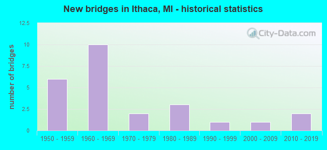
- New bridges - historical statistics
- 61950-1959
- 101960-1969
- 21970-1979
- 31980-1989
- 11990-1999
- 12000-2009
- 22010-2019
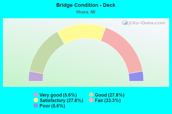
- Bridge Condition - Deck
- 5.6%Very good
- 27.8%Good
- 27.8%Satisfactory
- 33.3%Fair
- 5.6%Poor
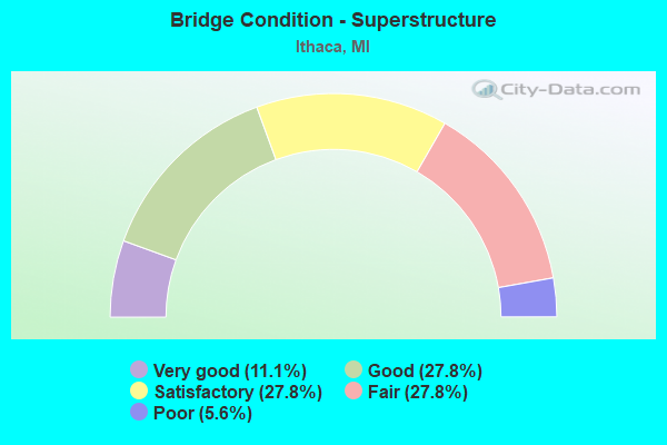
- Bridge Condition - Superstructure
- 11.1%Very good
- 27.8%Good
- 27.8%Satisfactory
- 27.8%Fair
- 5.6%Poor
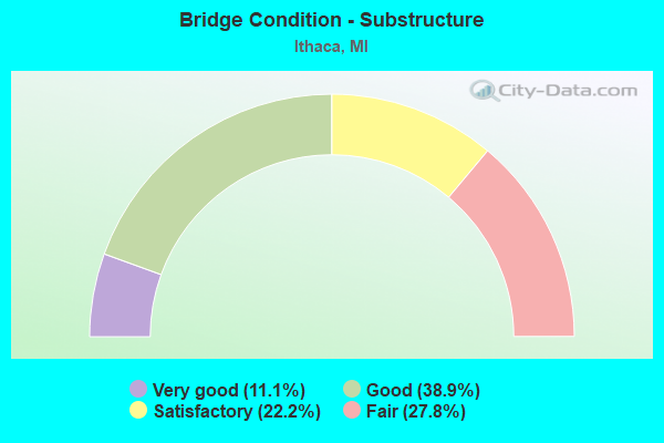
- Bridge Condition - Substructure
- 11.1%Very good
- 38.9%Good
- 22.2%Satisfactory
- 27.8%Fair
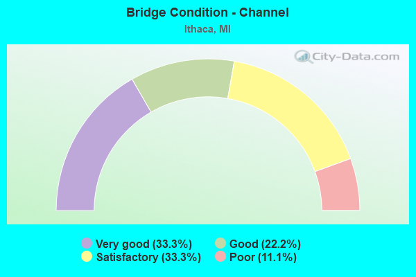
- Bridge Condition - Channel
- 33.3%Very good
- 22.2%Good
- 33.3%Satisfactory
- 11.1%Poor
Find on map >> Show street view
Structure Number: 308, Location: 5.3 MI SE OF ITHACA (Lat: 43.244572, Lng: -84.563092), Route carried "on" structure: US 127, Year Built: 1987, Status: Open, Structure Length: 1.15m (3.77ft), Average Daily Traffic: 9,134 (year 2007), Truck Traffic: 9%, Average Future Daily Traffic: 11,067 (year 2018), Design Load: HS 25 or greater, Features Intersected: N BR BAD RIVER
Minimum Vertical Clearance: 30.48m (100.00ft), Kilometerpoint: 14.087, Lanes on structure: 2, Base Highway Network: Yes (Inventory Route: 49, Subroute: 3), Owner: State Highway Agency, Approaching Roadway Width: 12.8m (42.0ft), Skew: 4 degrees, Material/Design: Prestressed concrete, Design/Construction: Box Beam or Girders - Multiple, Number Of Spans In Main Unit: 1, Length of Maximum Span: 11.5m (37.7ft), Curb-To-Curb Width: 13.4m (44.0ft), Out-to-Out Width: 14.4m (47.2ft)
Condition: Deck: Fair, Superstructure: Satisfactory, Substructure: Satisfactory, Channel: Poor, Operating Rating: 69.3 metric tons, Method Used To Determine Operating Rating: Load Factor (LF) rating reported by rating factor (RF) method using MS18 loading, Inventory Rating: 41.5 metric tons, Method Used To Determine Inventory Rating: Load Factor (LF) rating reported by rating factor (RF) method using MS18 loading, Structural Evaluation: Equal to present minimum criteria, Deck Geometry: Superior to present desirable criteria, Waterway Adequacy: High priority of corrective action, Approach Roadway Alignment: Equal to present desirable criteria, Designated Inspection Frequency: Every 24 months, Inspection Date: May 2021, Deck Structure Type: Concrete Cast-file-Place, Wearing Surface/Protective System: Wearing Surface: Bituminous, Deck Protection: Epoxy Coated Reinforcing
Find on map >> Show street view
Structure Number: 309, Location: 0.5 MI E OF ITHACA (Lat: 43.287142, Lng: -84.582097), Route carried "on" structure: US 127, Year Built: 1959, Status: Open, Structure Length: 5.09m (16.70ft), Average Daily Traffic: 8,987 (year 2007), Truck Traffic: 8%, Average Future Daily Traffic: 11,805 (year 2018), Design Load: HS 20, Features Intersected: MDOT RR CORRIDOR
Minimum Vertical Clearance: 30.48m (100.00ft), Kilometerpoint: 19.363, Lanes on structure: 2, Base Highway Network: Yes (Inventory Route: 49, Subroute: 3), Owner: State Highway Agency, Approaching Roadway Width: 17.7m (58.1ft), Skew: 13 degrees, Material/Design: Steel, Design/Construction: Stringer/Multi-beam, Number Of Spans In Main Unit: 3, Length of Maximum Span: 17.0m (55.8ft), Curb-To-Curb Width: 12.8m (42.0ft), Out-to-Out Width: 14.6m (47.9ft)
Condition: Deck: Fair, Superstructure: Satisfactory, Substructure: Fair, Operating Rating: 62.9 metric tons, Method Used To Determine Operating Rating: Load Factor (LF) rating reported by rating factor (RF) method using MS18 loading, Inventory Rating: 37.6 metric tons, Method Used To Determine Inventory Rating: Load Factor (LF) rating reported by rating factor (RF) method using MS18 loading, Structural Evaluation: Somewhat better than minimum adequacy, Deck Geometry: Equal to present desirable criteria, Underclear: Equal to present minimum criteria, Approach Roadway Alignment: Better than present minimum criteria, Designated Inspection Frequency: Every 24 months, Other Special Inspection Frequency: Every 12 months, Inspection Date: May 2021, Other Special Inspection Date: May 2021, Deck Structure Type: Concrete Cast-file-Place, Wearing Surface/Protective System: Wearing Surface: Epoxy Overlay
Find on map >> Show street view
Structure Number: 3091, Location: 0.5 MI E OF ITHACA (Lat: 43.287267, Lng: -84.582383), Route carried "on" structure: US 127, Year Built: 1959, Status: Open, Structure Length: 5.09m (16.70ft), Average Daily Traffic: 8,987 (year 2007), Truck Traffic: 8%, Average Future Daily Traffic: 11,805 (year 2018), Design Load: HS 20, Features Intersected: MDOT RR CORRIDOR
Minimum Vertical Clearance: 30.48m (100.00ft), Kilometerpoint: 19.376, Lanes on structure: 3, Base Highway Network: Yes (Inventory Route: 49, Subroute: 2), Owner: State Highway Agency, Approaching Roadway Width: 17.7m (58.1ft), Skew: 13 degrees, Material/Design: Steel, Design/Construction: Stringer/Multi-beam, Number Of Spans In Main Unit: 3, Length of Maximum Span: 17.0m (55.8ft), Curb-To-Curb Width: 15.9m (52.2ft), Out-to-Out Width: 17.6m (57.7ft)
Condition: Deck: Fair, Superstructure: Fair, Substructure: Fair, Operating Rating: 61.6 metric tons, Method Used To Determine Operating Rating: Load Factor (LF) rating reported by rating factor (RF) method using MS18 loading, Inventory Rating: 36.9 metric tons, Method Used To Determine Inventory Rating: Load Factor (LF) rating reported by rating factor (RF) method using MS18 loading, Structural Evaluation: Somewhat better than minimum adequacy, Deck Geometry: Better than present minimum criteria, Underclear: Equal to present minimum criteria, Approach Roadway Alignment: Better than present minimum criteria, Designated Inspection Frequency: Every 24 months, Other Special Inspection Frequency: Every 12 months, Inspection Date: May 2021, Other Special Inspection Date: May 2021, Deck Structure Type: Concrete Cast-file-Place, Wearing Surface/Protective System: Wearing Surface: Epoxy Overlay
Find on map >> Show street view
Structure Number: 3094, Location: 1.0 MI E OF ITHACA (Lat: 43.291650, Lng: -84.582067), Route carried "on" structure: US 127, Year Built: 1959, Status: Open, Structure Length: 4.08m (13.39ft), Average Daily Traffic: 8,987 (year 2007), Truck Traffic: 7%, Average Future Daily Traffic: 12,958 (year 2018), Design Load: HS 20, Features Intersected: US-127 BR
Minimum Vertical Clearance: 30.48m (100.00ft), Kilometerpoint: 19.863, Lanes on structure: 2, Lanes under structure: 4, Base Highway Network: Yes (Inventory Route: 49, Subroute: 3), Owner: State Highway Agency, Approaching Roadway Width: 17.6m (57.7ft), Skew: 10 degrees, Material/Design: Steel, Design/Construction: Stringer/Multi-beam, Number Of Spans In Main Unit: 3, Length of Maximum Span: 19.2m (63.0ft), Curb-To-Curb Width: 12.8m (42.0ft), Out-to-Out Width: 14.4m (47.2ft)
Condition: Deck: Fair, Superstructure: Satisfactory, Substructure: Good, Operating Rating: 69.7 metric tons, Method Used To Determine Operating Rating: Load Factor (LF) rating reported by rating factor (RF) method using MS18 loading, Inventory Rating: 40.8 metric tons, Method Used To Determine Inventory Rating: Load Factor (LF) rating reported by rating factor (RF) method using MS18 loading, Structural Evaluation: Equal to present minimum criteria, Deck Geometry: Equal to present desirable criteria, Underclear: Somewhat better than minimum adequacy, Approach Roadway Alignment: Better than present minimum criteria, Designated Inspection Frequency: Every 24 months, Inspection Date: November 2020, Deck Structure Type: Concrete Cast-file-Place, Wearing Surface/Protective System: Wearing Surface: Latex Concrete
Find on map >> Show street view
Structure Number: 3096, Location: 2.0 MI N OF ITHACA (Lat: 43.320731, Lng: -84.602428), Route carried "on" structure: US 127, Year Built: 1961, Status: Open, Structure Length: 3.47m (11.38ft), Average Daily Traffic: 9,181 (year 2007), Truck Traffic: 8%, Average Future Daily Traffic: 11,606 (year 2018), Design Load: HS 20, Features Intersected: US-127 BR (POLK RD)
Minimum Vertical Clearance: 30.48m (100.00ft), Kilometerpoint: 23.615, Lanes on structure: 2, Lanes under structure: 2, Base Highway Network: Yes (Inventory Route: 49, Subroute: 2), Owner: State Highway Agency, Approaching Roadway Width: 17.6m (57.7ft), Material/Design: Prestressed concrete, Design/Construction: Stringer/Multi-beam, Number Of Spans In Main Unit: 3, Length of Maximum Span: 13.4m (44.0ft), Curb-To-Curb Width: 13.4m (44.0ft), Out-to-Out Width: 14.3m (46.9ft)
Condition: Deck: Poor, Superstructure: Poor, Substructure: Fair, Operating Rating: 63.2 metric tons, Method Used To Determine Operating Rating: Load Factor (LF) rating reported by rating factor (RF) method using MS18 loading, Inventory Rating: 37.6 metric tons, Method Used To Determine Inventory Rating: Load Factor (LF) rating reported by rating factor (RF) method using MS18 loading, Structural Evaluation: Meets minimum limits, Deck Geometry: Superior to present desirable criteria, Underclear: Meets minimum limits, Approach Roadway Alignment: Somewhat better than minimum adequacy, Designated Inspection Frequency: Every 24 months, Inspection Date: May 2021, Bridge Improvement Cost: $74,000, Deck Structure Type: Concrete Cast-file-Place, Wearing Surface/Protective System: Wearing Surface: Epoxy Overlay
Find on map >> Show street view
Structure Number: 3097, Location: 2.0 MI N OF ITHACA (Lat: 43.320725, Lng: -84.600781), Route carried "on" structure: US 127, Year Built: 1961, Status: Open, Structure Length: 3.47m (11.38ft), Average Daily Traffic: 9,181 (year 2007), Truck Traffic: 8%, Average Future Daily Traffic: 11,606 (year 2018), Design Load: HS 20, Features Intersected: US-127 BR (POLK RD)
Minimum Vertical Clearance: 30.48m (100.00ft), Kilometerpoint: 23.583, Lanes on structure: 2, Lanes under structure: 2, Base Highway Network: Yes (Inventory Route: 49, Subroute: 3), Owner: State Highway Agency, Approaching Roadway Width: 17.6m (57.7ft), Material/Design: Prestressed concrete, Design/Construction: Stringer/Multi-beam, Number Of Spans In Main Unit: 3, Length of Maximum Span: 13.4m (44.0ft), Curb-To-Curb Width: 13.4m (44.0ft), Out-to-Out Width: 14.3m (46.9ft)
Condition: Deck: Fair, Superstructure: Fair, Substructure: Fair, Operating Rating: 62.2 metric tons, Method Used To Determine Operating Rating: Load Factor (LF) rating reported by rating factor (RF) method using MS18 loading, Inventory Rating: 37.3 metric tons, Method Used To Determine Inventory Rating: Load Factor (LF) rating reported by rating factor (RF) method using MS18 loading, Structural Evaluation: Somewhat better than minimum adequacy, Deck Geometry: Superior to present desirable criteria, Underclear: Somewhat better than minimum adequacy, Approach Roadway Alignment: Better than present minimum criteria, Designated Inspection Frequency: Every 24 months, Inspection Date: May 2021, Deck Structure Type: Concrete Cast-file-Place, Wearing Surface/Protective System: Wearing Surface: Epoxy Overlay
Find on map >> Show street view
Structure Number: 3106, Location: 2.5 MI N OF ITHACA (Lat: 43.335178, Lng: -84.602378), Route carried "on" structure: County highway 2962, Year Built: 1964, Status: Open, Structure Length: 3.84m (12.60ft), Average Daily Traffic: 678 (year 1992), Truck Traffic: 1%, Average Future Daily Traffic: 580 (year 1977), Design Load: H 15, Features Intersected: US-127 SB, Facility Carried by Structure: TYLER RD
Minimum Vertical Clearance: 30.48m (100.00ft), Kilometerpoint: 18.122, Lanes on structure: 2, Lanes under structure: 2, Owner: State Highway Agency, Approaching Roadway Width: 10.9m (35.8ft), Material/Design: Prestressed concrete, Design/Construction: Stringer/Multi-beam, Number Of Spans In Main Unit: 3, Length of Maximum Span: 17.9m (58.7ft), Curb or Sidewalk Widths: Left: 0.7m (2.3ft), Right: 0.7m (2.3ft), Curb-To-Curb Width: 7.3m (24.0ft), Out-to-Out Width: 9.5m (31.2ft)
Condition: Deck: Satisfactory, Superstructure: Satisfactory, Substructure: Good, Operating Rating: 58.0 metric tons, Method Used To Determine Operating Rating: Load Factor (LF) rating reported by rating factor (RF) method using MS18 loading, Inventory Rating: 34.3 metric tons, Method Used To Determine Inventory Rating: Load Factor (LF) rating reported by rating factor (RF) method using MS18 loading, Structural Evaluation: Equal to present minimum criteria, Deck Geometry: Meets minimum limits, Underclear: Somewhat better than minimum adequacy, Approach Roadway Alignment: Equal to present desirable criteria, Designated Inspection Frequency: Every 24 months, Inspection Date: May 2021, Deck Structure Type: Concrete Cast-file-Place, Wearing Surface/Protective System: Wearing Surface: Monolithic Concrete
Find on map >> Show street view
Structure Number: 3108, Location: @ N ITHACA CITY LTS (Lat: 43.306172, Lng: -84.596531), Route carried "on" structure: County highway , Year Built: 1965, Status: Open, Structure Length: 7.04m (23.10ft), Average Daily Traffic: 324 (year 1997), Truck Traffic: 2%, Average Future Daily Traffic: 90 (year 1977), Design Load: H 15, Features Intersected: US-127 / MID MI PATH, Facility Carried by Structure: ST CHARLES RD
Minimum Vertical Clearance: 30+ m (98+ ft), Kilometerpoint: 20.187, Lanes on structure: 2, Lanes under structure: 4, Owner: State Highway Agency, Approaching Roadway Width: 10.9m (35.8ft), Skew: 2 degrees, Material/Design: Steel, Design/Construction: Stringer/Multi-beam, Number Of Spans In Main Unit: 4, Length of Maximum Span: 24.3m (79.7ft), Curb or Sidewalk Widths: Left: 0.7m (2.3ft), Right: 0.7m (2.3ft), Curb-To-Curb Width: 7.3m (24.0ft), Out-to-Out Width: 9.5m (31.2ft)
Condition: Deck: Satisfactory, Superstructure: Satisfactory, Substructure: Good, Operating Rating: 65.8 metric tons, Method Used To Determine Operating Rating: Load Factor (LF) rating reported by rating factor (RF) method using MS18 loading, Inventory Rating: 33.7 metric tons, Method Used To Determine Inventory Rating: Load Factor (LF) rating reported by rating factor (RF) method using MS18 loading, Structural Evaluation: Equal to present minimum criteria, Deck Geometry: Somewhat better than minimum adequacy, Underclear: Somewhat better than minimum adequacy, Approach Roadway Alignment: Better than present minimum criteria, Designated Inspection Frequency: Every 24 months, Inspection Date: May 2021, Bridge Improvement Cost: $103,000, Deck Structure Type: Concrete Cast-file-Place, Wearing Surface/Protective System: Wearing Surface: Epoxy Overlay
Find on map >> Show street view
Structure Number: 3109, Location: 2.5 MI N OF ITHACA (Lat: 43.335178, Lng: -84.601264), Route carried "on" structure: County highway 2962, Year Built: 1964, Status: Open, Structure Length: 3.84m (12.60ft), Average Daily Traffic: 678 (year 1992), Truck Traffic: 1%, Average Future Daily Traffic: 780 (year 2012), Design Load: H 15, Features Intersected: US-127 NB / MID MI PATH, Facility Carried by Structure: TYLER RD
Minimum Vertical Clearance: 30.48m (100.00ft), Kilometerpoint: 18.212, Lanes on structure: 2, Lanes under structure: 2, Owner: State Highway Agency, Approaching Roadway Width: 10.9m (35.8ft), Material/Design: Prestressed concrete, Design/Construction: Stringer/Multi-beam, Number Of Spans In Main Unit: 3, Length of Maximum Span: 17.9m (58.7ft), Curb or Sidewalk Widths: Left: 0.7m (2.3ft), Right: 0.7m (2.3ft), Curb-To-Curb Width: 7.3m (24.0ft), Out-to-Out Width: 9.5m (31.2ft)
Condition: Deck: Fair, Superstructure: Fair, Substructure: Good, Operating Rating: 56.4 metric tons, Method Used To Determine Operating Rating: Load Factor (LF) rating reported by rating factor (RF) method using MS18 loading, Inventory Rating: 33.7 metric tons, Method Used To Determine Inventory Rating: Load Factor (LF) rating reported by rating factor (RF) method using MS18 loading, Structural Evaluation: Somewhat better than minimum adequacy, Deck Geometry: Meets minimum limits, Underclear: Somewhat better than minimum adequacy, Approach Roadway Alignment: Equal to present desirable criteria, Designated Inspection Frequency: Every 24 months, Inspection Date: May 2021, Deck Structure Type: Concrete Cast-file-Place, Wearing Surface/Protective System: Wearing Surface: Monolithic Concrete
Find on map >> Show street view
Structure Number: 3136, Location: SEC 16-21 NEWARK TWP (Lat: 43.248336, Lng: -84.664969), Route carried "on" structure: County highway 2938, Year Built: 2007, Status: Open, Structure Length: 0.91m (2.99ft), Average Daily Traffic: 216 (year 2005), Truck Traffic: 3%, Average Future Daily Traffic: 390 (year 2025), Design Load: HS 20, Features Intersected: DRAIN #1, Facility Carried by Structure: BUCHANAN ROAD
Minimum Vertical Clearance: 30.48m (100.00ft), Kilometerpoint: 13.860, Lanes on structure: 2, Owner: County Highway Agency, Approaching Roadway Width: 10.4m (34.1ft), Skew: 1 degrees, Material/Design: Prestressed concrete, Design/Construction: Box Beam or Girders - Multiple, Number Of Spans In Main Unit: 1, Length of Maximum Span: 7.9m (25.9ft), Curb-To-Curb Width: 10.4m (34.1ft), Out-to-Out Width: 11.5m (37.7ft)
Condition: Deck: Good, Superstructure: Very good, Substructure: Good, Channel: Very good, Inventory Rating: 68.8 metric tons, Method Used To Determine Inventory Rating: Load Factor (LF), Structural Evaluation: Better than present minimum criteria, Deck Geometry: Better than present minimum criteria, Waterway Adequacy: Equal to present desirable criteria, Approach Roadway Alignment: Equal to present desirable criteria, Designated Inspection Frequency: Every 24 months, Inspection Date: June 2021, Deck Structure Type: Concrete Cast-file-Place, Wearing Surface/Protective System: Wearing Surface: Monolithic Concrete, Deck Protection: Epoxy Coated Reinforcing
Find on map >> Show street view
Structure Number: 314, Location: SEC 16-21 NORTH STAR TWP (Lat: 43.248089, Lng: -84.556400), Route carried "on" structure: County highway 2938, Year Built: 1952, Status: Open, Structure Length: 0.91m (2.99ft), Average Daily Traffic: 910 (year 2003), Average Future Daily Traffic: 1,230 (year 2023), Design Load: HS 20+Mod, Features Intersected: DRAIN #294, Facility Carried by Structure: BUCHANAN ROAD
Minimum Vertical Clearance: 30.48m (100.00ft), Kilometerpoint: 22.675, Lanes on structure: 2, Owner: County Highway Agency, Approaching Roadway Width: 10.1m (33.1ft), Material/Design: Concrete, Design/Construction: Tee Beam, Number Of Spans In Main Unit: 1, Length of Maximum Span: 8.8m (28.9ft), Curb-To-Curb Width: 7.0m (23.0ft), Out-to-Out Width: 8.9m (29.2ft)
Condition: Deck: Satisfactory, Superstructure: Good, Substructure: Satisfactory, Channel: Satisfactory, Operating Rating: 74.8 metric tons, Method Used To Determine Operating Rating: Load Factor (LF) rating reported by rating factor (RF) method using MS18 loading, Inventory Rating: 45.0 metric tons, Method Used To Determine Inventory Rating: Load Factor (LF) rating reported by rating factor (RF) method using MS18 loading, Structural Evaluation: Equal to present minimum criteria, Deck Geometry: Meets minimum limits, Waterway Adequacy: Better than present minimum criteria, Approach Roadway Alignment: Better than present minimum criteria, Designated Inspection Frequency: Every 24 months, Inspection Date: June 2021, Deck Structure Type: Concrete Cast-file-Place, Wearing Surface/Protective System: Wearing Surface: Bituminous
Find on map >> Show street view
Structure Number: 316, Location: SEC 15-16 NEWARK TWP (Lat: 43.251936, Lng: -84.660092), Route carried "on" structure: County highway , Year Built: 1986, Status: Open, Structure Length: 1.28m (4.20ft), Average Daily Traffic: 1,145 (year 2003), Average Future Daily Traffic: 1,545 (year 2023), Design Load: HS 20+Mod, Features Intersected: DRAIN #1, Facility Carried by Structure: ALGER ROAD
Minimum Vertical Clearance: 30.48m (100.00ft), Kilometerpoint: 12.473, Lanes on structure: 2, Owner: County Highway Agency, Approaching Roadway Width: 9.1m (29.9ft), Skew: 4 degrees, Material/Design: Concrete, Design/Construction: Slab, Number Of Spans In Main Unit: 1, Length of Maximum Span: 12.8m (42.0ft), Curb-To-Curb Width: 10.1m (33.1ft), Out-to-Out Width: 11.5m (37.7ft)
Condition: Deck: Good, Superstructure: Good, Substructure: Good, Channel: Very good, Operating Rating: 57.0 metric tons, Method Used To Determine Operating Rating: Load Factor (LF) rating reported by rating factor (RF) method using MS18 loading, Inventory Rating: 34.3 metric tons, Method Used To Determine Inventory Rating: Load Factor (LF) rating reported by rating factor (RF) method using MS18 loading, Structural Evaluation: Better than present minimum criteria, Deck Geometry: Somewhat better than minimum adequacy, Waterway Adequacy: Equal to present desirable criteria, Approach Roadway Alignment: Equal to present desirable criteria, Designated Inspection Frequency: Every 24 months, Inspection Date: June 2021, Deck Structure Type: Concrete Cast-file-Place, Wearing Surface/Protective System: Wearing Surface: Monolithic Concrete, Deck Protection: Epoxy Coated Reinforcing
Find on map >> Show street view
Structure Number: 3166, Location: SEC 31 NORTH STAR TWP (Lat: 43.215942, Lng: -84.600803), Route carried "on" structure: County highway 2951, Year Built: 1984, Status: Open, Structure Length: 0.85m (2.79ft), Average Daily Traffic: 1,020 (year 2003), Average Future Daily Traffic: 1,375 (year 2023), Design Load: HS 20+Mod, Features Intersected: BEAR CREEK DRAIN, Facility Carried by Structure: STATE ROAD
Minimum Vertical Clearance: 30.48m (100.00ft), Kilometerpoint: 9.476, Lanes on structure: 2, Owner: County Highway Agency, Approaching Roadway Width: 9.1m (29.9ft), Skew: 3 degrees, Material/Design: Prestressed concrete, Number Of Spans In Main Unit: 1, Length of Maximum Span: 7.9m (25.9ft), Curb-To-Curb Width: 10.1m (33.1ft), Out-to-Out Width: 10.9m (35.8ft)
Condition: Deck: Good, Superstructure: Fair, Substructure: Satisfactory, Channel: Satisfactory, Operating Rating: 69.3 metric tons, Method Used To Determine Operating Rating: Load Factor (LF), Inventory Rating: 41.5 metric tons, Method Used To Determine Inventory Rating: Load Factor (LF), Structural Evaluation: Somewhat better than minimum adequacy, Deck Geometry: Somewhat better than minimum adequacy, Waterway Adequacy: Equal to present desirable criteria, Approach Roadway Alignment: Equal to present desirable criteria, Designated Inspection Frequency: Every 24 months, Inspection Date: June 2021, Deck Structure Type: Concrete Precast Panels, Wearing Surface/Protective System: Wearing Surface: Bituminous, Membrane: Built-up
Find on map >> Show street view
Structure Number: 3168, Location: SEC 3-4 NORTH STAR TWP (Lat: 43.282758, Lng: -84.543469), Route carried "on" structure: County highway , Year Built: 2010, Status: Open, Structure Length: 1.55m (5.09ft), Average Daily Traffic: 529 (year 2009), Average Future Daily Traffic: 786 (year 2029), Design Load: Greater than HL93, Features Intersected: BAD RIVER, Facility Carried by Structure: BALDWIN ROAD
Minimum Vertical Clearance: 30.48m (100.00ft), Kilometerpoint: 15.101, Lanes on structure: 2, Owner: County Highway Agency, Approaching Roadway Width: 10.4m (34.1ft), Skew: 1 degrees, Material/Design: Prestressed concrete, Design/Construction: Stringer/Multi-beam, Number Of Spans In Main Unit: 1, Length of Maximum Span: 14.0m (45.9ft), Curb-To-Curb Width: 10.4m (34.1ft), Out-to-Out Width: 11.0m (36.1ft)
Condition: Deck: Very good, Superstructure: Good, Substructure: Very good, Channel: Satisfactory, Inventory Rating: 60.3 metric tons, Method Used To Determine Inventory Rating: Load Factor (LF), Structural Evaluation: Better than present minimum criteria, Deck Geometry: Equal to present minimum criteria, Waterway Adequacy: Better than present minimum criteria, Approach Roadway Alignment: Better than present minimum criteria, Designated Inspection Frequency: Every 24 months, Inspection Date: May 2021, Deck Structure Type: Concrete Cast-file-Place, Wearing Surface/Protective System: Wearing Surface: Monolithic Concrete, Deck Protection: Epoxy Coated Reinforcing
Find on map >> Show street view
Structure Number: 3221, Location: SEC 10-15 NEWARK TWP (Lat: 43.262764, Lng: -84.654917), Route carried "on" structure: County highway , Year Built: 1973, Status: Open, Structure Length: 0.94m (3.08ft), Average Daily Traffic: 112 (year 2004), Average Future Daily Traffic: 139 (year 2024), Design Load: HS 20+Mod, Features Intersected: DRAIN #1, Facility Carried by Structure: PIERCE ROAD
Minimum Vertical Clearance: 30.48m (100.00ft), Kilometerpoint: 14.668, Lanes on structure: 2, Owner: County Highway Agency, Approaching Roadway Width: 5.5m (18.0ft), Material/Design: Prestressed concrete, Design/Construction: Box Beam or Girders - Multiple, Number Of Spans In Main Unit: 1, Length of Maximum Span: 7.9m (25.9ft), Curb-To-Curb Width: 7.0m (23.0ft), Out-to-Out Width: 7.3m (24.0ft)
Condition: Deck: Good, Superstructure: Good, Substructure: Fair, Channel: Good, Operating Rating: 64.9 metric tons, Method Used To Determine Operating Rating: Load Factor (LF), Inventory Rating: 38.8 metric tons, Method Used To Determine Inventory Rating: Load Factor (LF), Structural Evaluation: Somewhat better than minimum adequacy, Deck Geometry: Meets minimum limits, Waterway Adequacy: Better than present minimum criteria, Approach Roadway Alignment: Equal to present minimum criteria, Designated Inspection Frequency: Every 24 months, Inspection Date: July 2020, Deck Structure Type: Concrete Precast Panels, Wearing Surface/Protective System: Wearing Surface: Bituminous
Find on map >> Show street view
Structure Number: 3232, Location: SEC 14-15 NORTH STAR TWP (Lat: 43.259858, Lng: -84.523464), Route carried "on" structure: County highway , Year Built: 2013, Status: Open, Structure Length: 1.46m (4.79ft), Average Daily Traffic: 92 (year 2012), Truck Traffic: 7%, Average Future Daily Traffic: 141 (year 2024), Design Load: Greater than HL93, Features Intersected: BAD RIVER, Facility Carried by Structure: CRAPO ROAD
Minimum Vertical Clearance: 30.48m (100.00ft), Kilometerpoint: 12.563, Lanes on structure: 2, Owner: County Highway Agency, Approaching Roadway Width: 9.1m (29.9ft), Material/Design: Prestressed concrete, Design/Construction: Box Beam or Girders - Single/Spread, Number Of Spans In Main Unit: 1, Length of Maximum Span: 13.9m (45.6ft), Curb-To-Curb Width: 9.1m (29.9ft), Out-to-Out Width: 10.1m (33.1ft)
Condition: Deck: Good, Superstructure: Very good, Substructure: Very good, Channel: Good, Operating Rating: 79.4 metric tons, Method Used To Determine Operating Rating: Load and Resistance Factor Rating (LRFR) rating reported by rating factor(RF) method using HL-93 loadings, Inventory Rating: 61.2 metric tons, Method Used To Determine Inventory Rating: Load and Resistance Factor Rating (LRFR) rating reported by rating factor(RF) method using HL-93 loadings, Structural Evaluation: Equal to present desirable criteria, Deck Geometry: Better than present minimum criteria, Waterway Adequacy: Equal to present desirable criteria, Approach Roadway Alignment: Equal to present minimum criteria, Designated Inspection Frequency: Every 24 months, Inspection Date: June 2021, Deck Structure Type: Concrete Cast-file-Place, Wearing Surface/Protective System: Wearing Surface: Monolithic Concrete, Deck Protection: Epoxy Coated Reinforcing
Find on map >> Show street view
Structure Number: 3233, Location: SEC 13-14 NORTH STAR TWP (Lat: 43.257422, Lng: -84.503872), Route carried "on" structure: County highway , Year Built: 1978, Status: Open, Structure Length: 1.12m (3.67ft), Average Daily Traffic: 114 (year 2004), Average Future Daily Traffic: 139 (year 2024), Design Load: HS 20+Mod, Features Intersected: BAD RIVER DRAIN, Facility Carried by Structure: BLAIR ROAD
Minimum Vertical Clearance: 30.48m (100.00ft), Kilometerpoint: 15.521, Lanes on structure: 2, Owner: County Highway Agency, Approaching Roadway Width: 6.1m (20.0ft), Material/Design: Prestressed concrete, Design/Construction: Tee Beam, Number Of Spans In Main Unit: 1, Length of Maximum Span: 10.3m (33.8ft), Curb-To-Curb Width: 7.3m (24.0ft), Out-to-Out Width: 7.9m (25.9ft)
Condition: Deck: Satisfactory, Superstructure: Fair, Substructure: Satisfactory, Channel: Very good, Operating Rating: 78.3 metric tons, Method Used To Determine Operating Rating: Load Factor (LF), Inventory Rating: 46.9 metric tons, Method Used To Determine Inventory Rating: Load Factor (LF), Structural Evaluation: Somewhat better than minimum adequacy, Deck Geometry: Somewhat better than minimum adequacy, Waterway Adequacy: Equal to present desirable criteria, Approach Roadway Alignment: Better than present minimum criteria, Designated Inspection Frequency: Every 24 months, Inspection Date: July 2020, Deck Structure Type: Concrete Precast Panels, Wearing Surface/Protective System: Wearing Surface: Bituminous
Find on map >> Show street view
Structure Number: 3254, Location: CITY OF ITHACA (Lat: 43.291661, Lng: -84.612308), Route carried "on" structure: City street 101, Year Built: 1990, Status: Open, Structure Length: 2.71m (8.89ft), Average Daily Traffic: 4,222 (year 2004), Truck Traffic: 7%, Average Future Daily Traffic: 4,550 (year 2024), Design Load: HS 20+Mod, Features Intersected: TUSCOLA & SAGINAW BAY RR, Facility Carried by Structure: WEST CENTER STREET
Minimum Vertical Clearance: 30.48m (100.00ft), Kilometerpoint: 19.705, Lanes on structure: 2, Owner: City or Municipal Highway Agency, Approaching Roadway Width: 14.6m (47.9ft), Skew: 3 degrees, Material/Design: Prestressed concrete, Design/Construction: Box Beam or Girders - Multiple, Number Of Spans In Main Unit: 3, Length of Maximum Span: 9.1m (29.9ft), Curb or Sidewalk Widths: Left: 1.8m (5.9ft), Right: 1.8m (5.9ft), Curb-To-Curb Width: 14.6m (47.9ft), Out-to-Out Width: 15.4m (50.5ft)
Condition: Deck: Satisfactory, Superstructure: Good, Substructure: Good, Operating Rating: 68.8 metric tons, Method Used To Determine Operating Rating: Load Factor (LF), Inventory Rating: 41.2 metric tons, Method Used To Determine Inventory Rating: Load Factor (LF), Structural Evaluation: Better than present minimum criteria, Deck Geometry: Superior to present desirable criteria, Approach Roadway Alignment: Equal to present desirable criteria, Designated Inspection Frequency: Every 24 months, Inspection Date: July 2020, Deck Structure Type: Concrete Cast-file-Place, Wearing Surface/Protective System: Wearing Surface: Monolithic Concrete, Deck Protection: Epoxy Coated Reinforcing
Find on map >> Show street view
Structure Number: 3094, Location: 1.0 MI E OF ITHACA (Lat: 43.291650, Lng: -84.582067), Route carried "under" structure: Business US 127, Year Built: 1959, Structure Length: 0. m, Average Daily Traffic: 8,167 (year 2007), Truck Traffic: 1%, Features Intersected: US-127 BR
Minimum Vertical Clearance: 4.85m (15.91ft), Kilometerpoint: 17.253, Lanes on structure: 2, Lanes under structure: 4, Material/Design: Steel, Design/Construction: Stringer/Multi-beam, Length of Maximum Span: 19.2m (63.0ft)
Find on map >> Show street view
Structure Number: 3095, Location: 1.0 MI E OF ITHACA (Lat: 43.291647, Lng: -84.582336), Route carried "under" structure: Business US 127, Year Built: 1959, Structure Length: 0. m, Average Daily Traffic: 8,167 (year 2007), Truck Traffic: 1%, Features Intersected: US-127 BR
Minimum Vertical Clearance: 4.65m (15.26ft), Kilometerpoint: 17.275, Lanes on structure: 2, Lanes under structure: 4, Material/Design: Steel, Design/Construction: Stringer/Multi-beam, Length of Maximum Span: 19.2m (63.0ft)
Find on map >> Show street view
Structure Number: 3096, Location: 2.0 MI N OF ITHACA (Lat: 43.320731, Lng: -84.602428), Route carried "under" structure: Business US 127, Year Built: 1961, Structure Length: 0. m, Average Daily Traffic: 970 (year 2007), Truck Traffic: 5%, Features Intersected: US-127 BR (POLK RD)
Minimum Vertical Clearance: 4.42m (14.50ft), Kilometerpoint: 0.431, Lanes on structure: 2, Lanes under structure: 2, Material/Design: Prestressed concrete, Design/Construction: Stringer/Multi-beam, Length of Maximum Span: 13.4m (44.0ft)
Find on map >> Show street view
Structure Number: 3097, Location: 2.0 MI N OF ITHACA (Lat: 43.320725, Lng: -84.600781), Route carried "under" structure: Business US 127, Year Built: 1961, Structure Length: 0. m, Average Daily Traffic: 970 (year 2007), Truck Traffic: 5%, Features Intersected: US-127 BR (POLK RD)
Minimum Vertical Clearance: 4.50m (14.76ft), Kilometerpoint: 0.565, Lanes on structure: 2, Lanes under structure: 2, Material/Design: Prestressed concrete, Design/Construction: Stringer/Multi-beam, Length of Maximum Span: 13.4m (44.0ft)
Find on map >> Show street view
Structure Number: 3106, Location: 2.5 MI N OF ITHACA (Lat: 43.335178, Lng: -84.602378), Route carried "under" structure: US 127, Year Built: 1964, Structure Length: 0. m, Average Daily Traffic: 9,181 (year 2007), Truck Traffic: 8%, Features Intersected: US-127 SB, Facility Carried by Structure: TYLER RD
Minimum Vertical Clearance: 5.11m (16.77ft), Kilometerpoint: 25.221, Lanes on structure: 2, Lanes under structure: 2, Material/Design: Prestressed concrete, Design/Construction: Stringer/Multi-beam, Length of Maximum Span: 17.9m (58.7ft)
Find on map >> Show street view
Structure Number: 3108, Location: @ N ITHACA CITY LTS (Lat: 43.306172, Lng: -84.596531), Route carried "under" structure: US 127, Year Built: 1965, Structure Length: 0. m, Average Daily Traffic: 22,600 (year 2016), Truck Traffic: 9%, Features Intersected: US-127 / MID MI PATH, Facility Carried by Structure: ST CHARLES RD
Minimum Vertical Clearance: 5.00m (16.40ft), Kilometerpoint: 21.902, Lanes on structure: 2, Lanes under structure: 4, Material/Design: Steel, Design/Construction: Stringer/Multi-beam, Length of Maximum Span: 24.3m (79.7ft)
Find on map >> Show street view
Structure Number: 3109, Location: 2.5 MI N OF ITHACA (Lat: 43.335178, Lng: -84.601264), Route carried "under" structure: US 127, Year Built: 1964, Structure Length: 0. m, Average Daily Traffic: 11,300 (year 2016), Truck Traffic: 9%, Features Intersected: US-127 NB / MID MI PATH, Facility Carried by Structure: TYLER RD
Minimum Vertical Clearance: 4.95m (16.24ft), Kilometerpoint: 25.189, Lanes on structure: 2, Lanes under structure: 2, Material/Design: Prestressed concrete, Design/Construction: Stringer/Multi-beam, Length of Maximum Span: 17.9m (58.7ft)