Bridge Statistics for Jamestown, Indiana (IN)
Condition, Traffic, Stress, Structural Evaluation, Project Costs
- National Bridge Inventory (NBI) Statistics
- 25Number of bridges
- 184ft / 55.6mTotal length
- $580,000Total costs
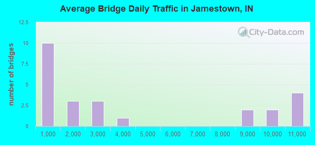
- 96,552Total average daily traffic
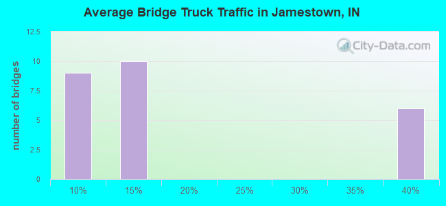
- 25,398Total average daily truck traffic
- National Bridge Inventory (NBI) Registered Bridges for Jamestown
- No street view available for this location
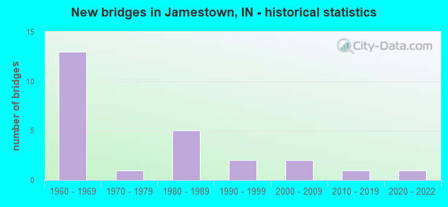
- New bridges - historical statistics
- 131960-1969
- 11970-1979
- 51980-1989
- 21990-1999
- 22000-2009
- 12010-2019
- 12020-2022
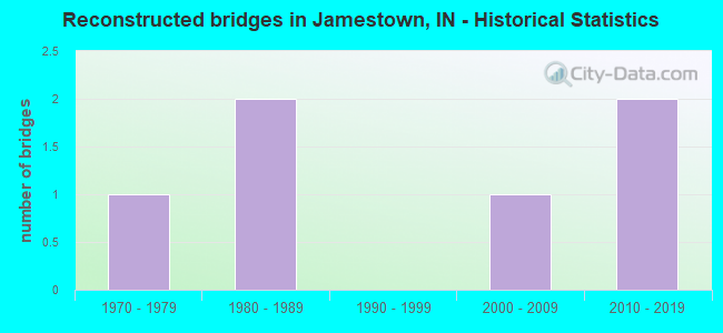
- Reconstructed bridges - Historical Statistics
- 11970-1979
- 21980-1989
- 01990-1999
- 12000-2009
- 22010-2019
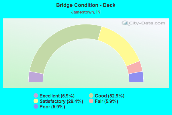
- Bridge Condition - Deck
- 5.9%Excellent
- 52.9%Good
- 29.4%Satisfactory
- 5.9%Fair
- 5.9%Poor
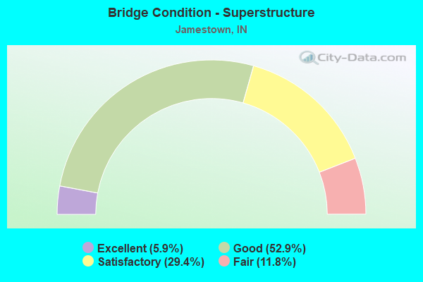
- Bridge Condition - Superstructure
- 5.9%Excellent
- 52.9%Good
- 29.4%Satisfactory
- 11.8%Fair
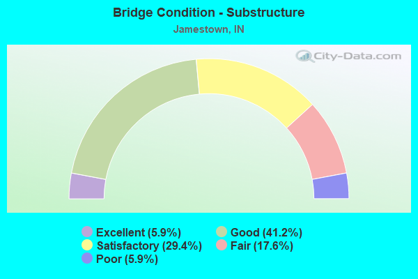
- Bridge Condition - Substructure
- 5.9%Excellent
- 41.2%Good
- 29.4%Satisfactory
- 17.6%Fair
- 5.9%Poor
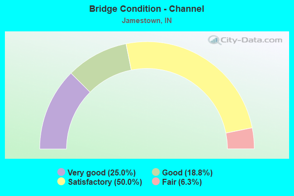
- Bridge Condition - Channel
- 25.0%Very good
- 18.8%Good
- 50.0%Satisfactory
- 6.3%Fair
Find on map >> Show street view
Structure Number: 2485, Location: 01.49 S SR 234 (Lat: 39.901969, Lng: -86.634869), Route carried "on" structure: State highway 75, Year Built: 1993, Status: Open, Structure Length: 4.51m (14.80ft), Average Daily Traffic: 1,658 (year 2004), Truck Traffic: 10%, Average Future Daily Traffic: 2,752 (year 2032), Design Load: HS 20, Features Intersected: WEST FK BIG WALNUT CREEK
Minimum Vertical Clearance: 30+ m (98+ ft), Kilometerpoint: 32.364, Lanes on structure: 2, Owner: State Highway Agency, Approaching Roadway Width: 10.4m (34.1ft), Skew: 5 degrees, Material/Design: Prestressed concrete continuous, Design/Construction: Stringer/Multi-beam, Number Of Spans In Main Unit: 3, Length of Maximum Span: 15.9m (52.2ft), Curb-To-Curb Width: 10.2m (33.5ft), Out-to-Out Width: 11.1m (36.4ft)
Condition: Deck: Good, Superstructure: Satisfactory, Substructure: Good, Channel: Good, Operating Rating: 43.3 metric tons, Method Used To Determine Operating Rating: Load Factor (LF), Inventory Rating: 25.9 metric tons, Method Used To Determine Inventory Rating: Load Factor (LF), Structural Evaluation: Equal to present minimum criteria, Deck Geometry: Somewhat better than minimum adequacy, Waterway Adequacy: Superior to present desirable criteria, Approach Roadway Alignment: Equal to present desirable criteria, Designated Inspection Frequency: Every 24 months, Inspection Date: December 2021, Deck Structure Type: Concrete Cast-file-Place, Wearing Surface/Protective System: Wearing Surface: Monolithic Concrete, Deck Protection: Epoxy Coated Reinforcing
Find on map >> Show street view
Structure Number: 2486, Location: 01.36 N SR 234 (Lat: 39.942381, Lng: -86.619719), Route carried "on" structure: State highway 75, Year Built: 1963, Year Reconstructed: 1983, Status: Open, Structure Length: 7.19m (23.59ft), Average Daily Traffic: 2,806 (year 2014), Truck Traffic: 6%, Average Future Daily Traffic: 4,066 (year 2033), Design Load: HS 20, Features Intersected: I-74 EB/WB
Minimum Vertical Clearance: 30+ m (98+ ft), Kilometerpoint: 2.945, Lanes on structure: 2, Lanes under structure: 4, Owner: State Highway Agency, Approaching Roadway Width: 7.3m (24.0ft), Skew: 2 degrees, Material/Design: Concrete continuous, Design/Construction: Stringer/Multi-beam, Number Of Spans In Main Unit: 4, Length of Maximum Span: 22.3m (73.2ft), Curb or Sidewalk Widths: Left: 0.6m (2.0ft), Right: 0.6m (2.0ft), Curb-To-Curb Width: 9.1m (29.9ft), Out-to-Out Width: 11.1m (36.4ft)
Condition: Deck: Poor, Superstructure: Fair, Substructure: Fair, Operating Rating: 56.9 metric tons, Method Used To Determine Operating Rating: Load Factor (LF), Inventory Rating: 34.1 metric tons, Method Used To Determine Inventory Rating: Load Factor (LF), Structural Evaluation: Somewhat better than minimum adequacy, Deck Geometry: Meets minimum limits, Underclear: Meets minimum limits, Approach Roadway Alignment: Equal to present desirable criteria, Designated Inspection Frequency: Every 12 months, Inspection Date: December 2021, Deck Structure Type: Concrete Cast-file-Place, Wearing Surface/Protective System: Wearing Surface: Latex Concrete
Find on map >> Show street view
Structure Number: 26891, Location: 02.55 W SR 75 (Lat: 39.942381, Lng: -86.669500), Route carried "on" structure: US 136, Year Built: 2008, Status: Open, Structure Length: 1.05m (3.44ft), Average Daily Traffic: 1,605 (year 2004), Truck Traffic: 10%, Average Future Daily Traffic: 2,665 (year 2030), Design Load: HS 20+Mod, Features Intersected: EMILY GARDNER DITCH
Minimum Vertical Clearance: 30+ m (98+ ft), Kilometerpoint: 2.623, Lanes on structure: 2, Owner: State Highway Agency, Approaching Roadway Width: 7.3m (24.0ft), Skew: 4 degrees, Material/Design: Concrete, Design/Construction: Culvert, Number Of Spans In Main Unit: 1, Length of Maximum Span: 9.5m (31.2ft)
Condition: Channel: Satisfactory, Culverts: Good, Operating Rating: 70.0 metric tons, Method Used To Determine Operating Rating: Load and Resistance Factor Rating (LRFR) rating reported by rating factor(RF) method using HL-93 loadings, Inventory Rating: 53.8 metric tons, Method Used To Determine Inventory Rating: Load and Resistance Factor Rating (LRFR) rating reported by rating factor(RF) method using HL-93 loadings, Structural Evaluation: Better than present minimum criteria, Waterway Adequacy: Superior to present desirable criteria, Approach Roadway Alignment: Equal to present desirable criteria, Designated Inspection Frequency: Every 24 months, Inspection Date: November 2020
Find on map >> Show street view
Structure Number: 269, Location: 00.67 E SR 75 (Lat: 39.920800, Lng: -86.616139), Route carried "on" structure: US 136, Year Built: 2002, Status: Open, Structure Length: 3.96m (12.99ft), Average Daily Traffic: 2,458 (year 2004), Truck Traffic: 10%, Average Future Daily Traffic: 4,081 (year 2034), Design Load: HS 20, Features Intersected: WEST FK BIG WALNUT CREEK
Minimum Vertical Clearance: 30+ m (98+ ft), Kilometerpoint: 0.338, Lanes on structure: 2, Owner: State Highway Agency, Approaching Roadway Width: 10.1m (33.1ft), Skew: 2 degrees, Material/Design: Prestressed concrete continuous, Design/Construction: Stringer/Multi-beam, Number Of Spans In Main Unit: 3, Length of Maximum Span: 13.2m (43.3ft), Curb-To-Curb Width: 9.4m (30.8ft), Out-to-Out Width: 10.3m (33.8ft)
Condition: Deck: Good, Superstructure: Good, Substructure: Good, Channel: Very good, Operating Rating: 68.5 metric tons, Method Used To Determine Operating Rating: Load Factor (LF), Inventory Rating: 39.4 metric tons, Method Used To Determine Inventory Rating: Load Factor (LF), Structural Evaluation: Better than present minimum criteria, Deck Geometry: Meets minimum limits, Waterway Adequacy: Superior to present desirable criteria, Approach Roadway Alignment: Equal to present desirable criteria, Designated Inspection Frequency: Every 24 months, Inspection Date: November 2020, Deck Structure Type: Concrete Cast-file-Place, Wearing Surface/Protective System: Wearing Surface: Monolithic Concrete, Deck Protection: Epoxy Coated Reinforcing
Find on map >> Show street view
Structure Number: 2691, Location: 02.06 E SR 75 (Lat: 39.910631, Lng: -86.593739), Route carried "on" structure: US 136, Year Built: 1985, Status: Open, Structure Length: 1.80m (5.91ft), Average Daily Traffic: 2,458 (year 2004), Truck Traffic: 10%, Average Future Daily Traffic: 4,081 (year 2030), Design Load: HS 20, Features Intersected: MIDDLE FK BIG WALNUT CR
Minimum Vertical Clearance: 30+ m (98+ ft), Kilometerpoint: 2.575, Lanes on structure: 2, Owner: State Highway Agency, Approaching Roadway Width: 13.4m (44.0ft), Material/Design: Concrete continuous, Design/Construction: Slab, Number Of Spans In Main Unit: 3, Length of Maximum Span: 7.0m (23.0ft), Curb-To-Curb Width: 13.4m (44.0ft), Out-to-Out Width: 14.2m (46.6ft)
Condition: Deck: Good, Superstructure: Good, Substructure: Good, Channel: Very good, Operating Rating: 60.0 metric tons, Method Used To Determine Operating Rating: Load Factor (LF), Inventory Rating: 35.9 metric tons, Method Used To Determine Inventory Rating: Load Factor (LF), Structural Evaluation: Better than present minimum criteria, Deck Geometry: Better than present minimum criteria, Waterway Adequacy: Superior to present desirable criteria, Approach Roadway Alignment: Equal to present desirable criteria, Designated Inspection Frequency: Every 24 months, Inspection Date: November 2020, Deck Structure Type: Concrete Cast-file-Place, Wearing Surface/Protective System: Wearing Surface: Monolithic Concrete, Deck Protection: Epoxy Coated Reinforcing
Find on map >> Show street view
Structure Number: 4429, Location: 00.89 E SR 75 (Lat: 39.936561, Lng: -86.604981), Route carried "on" structure: Alternate County highway , Year Built: 1963, Year Reconstructed: 1987, Status: Open, Structure Length: 6.88m (22.57ft), Average Daily Traffic: 1,743 (year 2004), Truck Traffic: 10%, Average Future Daily Traffic: 2,894 (year 2034), Design Load: HS 20, Features Intersected: I-74, Facility Carried by Structure: CR 700 S
Minimum Vertical Clearance: 30+ m (98+ ft), Kilometerpoint: 0.000, Lanes on structure: 2, Lanes under structure: 4, Owner: State Highway Agency, Approaching Roadway Width: 6.1m (20.0ft), Skew: 2 degrees, Material/Design: Concrete continuous, Design/Construction: Stringer/Multi-beam, Number Of Spans In Main Unit: 4, Length of Maximum Span: 21.3m (69.9ft), Curb-To-Curb Width: 8.0m (26.2ft), Out-to-Out Width: 9.0m (29.5ft)
Condition: Deck: Good, Superstructure: Satisfactory, Substructure: Fair, Operating Rating: 54.9 metric tons, Method Used To Determine Operating Rating: Load Factor (LF), Inventory Rating: 32.8 metric tons, Method Used To Determine Inventory Rating: Load Factor (LF), Structural Evaluation: Somewhat better than minimum adequacy, Deck Geometry: Meets minimum limits, Underclear: Meets minimum limits, Approach Roadway Alignment: Equal to present desirable criteria, Designated Inspection Frequency: Every 24 months, Inspection Date: September 2020, Deck Structure Type: Concrete Cast-file-Place, Wearing Surface/Protective System: Wearing Surface: Latex Concrete
Find on map >> Show street view
Structure Number: 443, Location: 01.64 E SR 75 (Lat: 39.929561, Lng: -86.594000), Route carried "on" structure: Interstate 74, Year Built: 1963, Year Reconstructed: 2018, Status: Open, Structure Length: 3.35m (10.99ft), Average Daily Traffic: 10,041 (year 2017), Truck Traffic: 38%, Average Future Daily Traffic: 14,920 (year 2037), Design Load: HS 20+Mod, Features Intersected: WEST FORK BIG WALNUT CR
Minimum Vertical Clearance: 30+ m (98+ ft), Kilometerpoint: 86.180, Lanes on structure: 2, Base Highway Network: Yes (, Subroute: 1), Owner: State Highway Agency, Approaching Roadway Width: 11.6m (38.1ft), Skew: 1 degrees, Material/Design: Concrete continuous, Design/Construction: Stringer/Multi-beam, Number Of Spans In Main Unit: 3, Length of Maximum Span: 10.4m (34.1ft), Curb-To-Curb Width: 12.2m (40.0ft), Out-to-Out Width: 13.2m (43.3ft)
Condition: Deck: Fair, Superstructure: Good, Substructure: Satisfactory, Channel: Good, Operating Rating: 67.2 metric tons, Method Used To Determine Operating Rating: Load Factor (LF), Inventory Rating: 40.4 metric tons, Method Used To Determine Inventory Rating: Load Factor (LF), Structural Evaluation: Equal to present minimum criteria, Deck Geometry: Better than present minimum criteria, Waterway Adequacy: Superior to present desirable criteria, Approach Roadway Alignment: Equal to present desirable criteria, Designated Inspection Frequency: Every 24 months, Inspection Date: August 2021, Deck Structure Type: Concrete Cast-file-Place, Wearing Surface/Protective System: Wearing Surface: Latex Concrete
Find on map >> Show street view
Structure Number: 4431, Location: 01.64 E SR 75 (Lat: 39.929781, Lng: -86.593931), Route carried "on" structure: Interstate 74, Year Built: 1963, Year Reconstructed: 2018, Status: Open, Structure Length: 3.35m (10.99ft), Average Daily Traffic: 10,041 (year 2017), Truck Traffic: 38%, Average Future Daily Traffic: 14,920 (year 2037), Design Load: HS 20+Mod, Features Intersected: WEST FORK BIG WALNUT CR
Minimum Vertical Clearance: 30+ m (98+ ft), Kilometerpoint: 86.180, Lanes on structure: 2, Base Highway Network: Yes (, Subroute: 1), Owner: State Highway Agency, Approaching Roadway Width: 11.6m (38.1ft), Skew: 1 degrees, Material/Design: Concrete continuous, Design/Construction: Stringer/Multi-beam, Number Of Spans In Main Unit: 3, Length of Maximum Span: 10.4m (34.1ft), Curb-To-Curb Width: 12.2m (40.0ft), Out-to-Out Width: 13.2m (43.3ft)
Condition: Deck: Satisfactory, Superstructure: Satisfactory, Substructure: Satisfactory, Channel: Very good, Operating Rating: 67.2 metric tons, Method Used To Determine Operating Rating: Load Factor (LF), Inventory Rating: 40.4 metric tons, Method Used To Determine Inventory Rating: Load Factor (LF), Structural Evaluation: Equal to present minimum criteria, Deck Geometry: Better than present minimum criteria, Waterway Adequacy: Superior to present desirable criteria, Approach Roadway Alignment: Equal to present desirable criteria, Designated Inspection Frequency: Every 24 months, Inspection Date: August 2021, Deck Structure Type: Concrete Cast-file-Place, Wearing Surface/Protective System: Wearing Surface: Latex Concrete
Find on map >> Show street view
Structure Number: 4432, Location: 02.32 E SR 75 (Lat: 39.923350, Lng: -86.584350), Route carried "on" structure: Alternate County highway , Year Built: 1963, Year Reconstructed: 1987, Status: Open, Structure Length: 6.71m (22.01ft), Average Daily Traffic: 3,984 (year 2004), Truck Traffic: 10%, Average Future Daily Traffic: 6,613 (year 2034), Design Load: HS 20, Features Intersected: I-74, Facility Carried by Structure: CR 800 S/CO LINE R
Minimum Vertical Clearance: 30+ m (98+ ft), Kilometerpoint: 0.000, Lanes on structure: 2, Lanes under structure: 4, Owner: State Highway Agency, Approaching Roadway Width: 6.1m (20.0ft), Skew: 1 degrees, Material/Design: Concrete continuous, Design/Construction: Stringer/Multi-beam, Number Of Spans In Main Unit: 4, Length of Maximum Span: 20.7m (67.9ft), Curb-To-Curb Width: 8.0m (26.2ft), Out-to-Out Width: 9.0m (29.5ft)
Condition: Deck: Good, Superstructure: Good, Substructure: Fair, Operating Rating: 54.8 metric tons, Method Used To Determine Operating Rating: Load Factor (LF), Inventory Rating: 32.8 metric tons, Method Used To Determine Inventory Rating: Load Factor (LF), Structural Evaluation: Somewhat better than minimum adequacy, Deck Geometry: High priority of corrective action, Underclear: Meets minimum limits, Approach Roadway Alignment: Equal to present desirable criteria, Designated Inspection Frequency: Every 24 months, Inspection Date: November 2020, Deck Structure Type: Concrete Cast-file-Place, Wearing Surface/Protective System: Wearing Surface: Latex Concrete
Find on map >> Show street view
Structure Number: 600152, Location: 00.75 W OF CR 675 W (Lat: 39.922731, Lng: -86.612000), Route carried "on" structure: County highway 800, Year Built: 1965, Status: Open, Structure Length: 3.10m (10.17ft), Average Daily Traffic: 340 (year 2017), Truck Traffic: 5%, Average Future Daily Traffic: 520 (year 2037), Features Intersected: W FORK BIG WALNUT CREEK
Minimum Vertical Clearance: 30+ m (98+ ft), Kilometerpoint: 0.000, Lanes on structure: 2, Owner: County Highway Agency, Approaching Roadway Width: 6.1m (20.0ft), Skew: 1 degrees, Material/Design: Concrete continuous, Design/Construction: Slab, Number Of Spans In Main Unit: 3, Length of Maximum Span: 12.3m (40.4ft), Curb or Sidewalk Widths: Left: 0.3m (1.0ft), Right: 0.3m (1.0ft), Curb-To-Curb Width: 7.3m (24.0ft), Out-to-Out Width: 7.9m (25.9ft)
Condition: Deck: Good, Superstructure: Good, Substructure: Good, Channel: Satisfactory, Operating Rating: 32.7 metric tons, Method Used To Determine Operating Rating: Field evaluation and documented engineering judgment, Inventory Rating: 32.7 metric tons, Method Used To Determine Inventory Rating: Field evaluation and documented engineering judgment, Structural Evaluation: Better than present minimum criteria, Deck Geometry: Somewhat better than minimum adequacy, Waterway Adequacy: Better than present minimum criteria, Approach Roadway Alignment: Equal to present desirable criteria, Designated Inspection Frequency: Every 24 months, Inspection Date: September 2021, Deck Structure Type: Concrete Cast-file-Place, Wearing Surface/Protective System: Wearing Surface: Monolithic Concrete
Find on map >> Show street view
Structure Number: 600153, Location: 00.30 N OF CR 750 S (Lat: 39.935319, Lng: -86.581639), Route carried "on" structure: County highway 600, Year Built: 1965, Year Reconstructed: 2009, Status: Open, Structure Length: 2.64m (8.66ft), Average Daily Traffic: 110 (year 2017), Truck Traffic: 5%, Average Future Daily Traffic: 170 (year 2037), Design Load: HS 20, Features Intersected: EDLIN DITCH
Minimum Vertical Clearance: 30+ m (98+ ft), Kilometerpoint: 0.000, Lanes on structure: 2, Owner: County Highway Agency, Approaching Roadway Width: 6.2m (20.3ft), Skew: 3 degrees, Material/Design: Prestressed concrete, Design/Construction: Box Beam or Girders - Multiple, Number Of Spans In Main Unit: 3, Length of Maximum Span: 9.3m (30.5ft), Curb-To-Curb Width: 8.6m (28.2ft), Out-to-Out Width: 8.6m (28.2ft)
Condition: Deck: Good, Superstructure: Good, Substructure: Good, Channel: Good, Operating Rating: 60.8 metric tons, Method Used To Determine Operating Rating: Load and Resistance Factor (LRFR), Inventory Rating: 50.3 metric tons, Method Used To Determine Inventory Rating: Load and Resistance Factor (LRFR), Structural Evaluation: Better than present minimum criteria, Deck Geometry: Equal to present minimum criteria, Waterway Adequacy: Better than present minimum criteria, Approach Roadway Alignment: Equal to present desirable criteria, Designated Inspection Frequency: Every 24 months, Inspection Date: September 2021, Deck Structure Type: Concrete Precast Panels, Wearing Surface/Protective System: Wearing Surface: Bituminous
Find on map >> Show street view
Structure Number: 600154, Location: 00.90 N OF CR 750 S (Lat: 39.941011, Lng: -86.581669), Route carried "on" structure: County highway 600, Year Built: 1980, Status: Open, Structure Length: 0.87m (2.85ft), Average Daily Traffic: 200 (year 2017), Truck Traffic: 5%, Average Future Daily Traffic: 300 (year 2037), Design Load: HS 20, Features Intersected: W FORK BIG WALNUT CREEK
Minimum Vertical Clearance: 30+ m (98+ ft), Kilometerpoint: 0.000, Lanes on structure: 2, Owner: County Highway Agency, Approaching Roadway Width: 5.8m (19.0ft), Skew: 4 degrees, Material/Design: Prestressed concrete, Design/Construction: Box Beam or Girders - Multiple, Number Of Spans In Main Unit: 1, Length of Maximum Span: 6.6m (21.7ft), Curb-To-Curb Width: 7.4m (24.3ft), Out-to-Out Width: 7.4m (24.3ft)
Condition: Deck: Satisfactory, Superstructure: Satisfactory, Substructure: Poor, Channel: Fair, Operating Rating: 47.5 metric tons, Method Used To Determine Operating Rating: Load and Resistance Factor (LRFR), Inventory Rating: 39.3 metric tons, Method Used To Determine Inventory Rating: Load and Resistance Factor (LRFR), Structural Evaluation: Meets minimum limits, Deck Geometry: Somewhat better than minimum adequacy, Waterway Adequacy: Equal to present minimum criteria, Approach Roadway Alignment: Equal to present minimum criteria, Length Of Structure Improvement: 1.52m (4.99ft), Designated Inspection Frequency: Every 12 months, Inspection Date: September 2021, Bridge Improvement Cost: $246,000, Roadway Improvement Cost: $214,000, Total Project Cost: $580,000 ( Estimate for 2019), Deck Structure Type: Concrete Precast Panels, Wearing Surface/Protective System: Wearing Surface: Bituminous
Find on map >> Show street view
Structure Number: 600155, Location: 00.20 N OF CR 800 S (Lat: 39.925839, Lng: -86.595889), Route carried "on" structure: Alternate County highway 675, Year Built: 1988, Status: Open, Structure Length: 2.08m (6.82ft), Average Daily Traffic: 10 (year 2017), Truck Traffic: 10%, Average Future Daily Traffic: 20 (year 2037), Features Intersected: W FORK BIG WALNUT CREEK
Minimum Vertical Clearance: 30+ m (98+ ft), Kilometerpoint: 0.000, Lanes on structure: 2, Owner: County Highway Agency, Approaching Roadway Width: 3.0m (9.8ft), Material/Design: Prestressed concrete, Design/Construction: Box Beam or Girders - Multiple, Number Of Spans In Main Unit: 2, Length of Maximum Span: 13.7m (44.9ft), Curb-To-Curb Width: 7.3m (24.0ft), Out-to-Out Width: 7.3m (24.0ft)
Condition: Deck: Satisfactory, Superstructure: Fair, Substructure: Satisfactory, Channel: Satisfactory, Operating Rating: 49.6 metric tons, Method Used To Determine Operating Rating: Load and Resistance Factor (LRFR), Inventory Rating: 36.3 metric tons, Method Used To Determine Inventory Rating: Load and Resistance Factor (LRFR), Structural Evaluation: Somewhat better than minimum adequacy, Deck Geometry: Equal to present minimum criteria, Waterway Adequacy: Better than present minimum criteria, Approach Roadway Alignment: Equal to present minimum criteria, Designated Inspection Frequency: Every 24 months, Inspection Date: September 2021, Deck Structure Type: Concrete Precast Panels, Wearing Surface/Protective System: Wearing Surface: Monolithic Concrete
Find on map >> Show street view
Structure Number: 600225, Location: 00.20 S OF CR 550 S (Lat: 39.954989, Lng: -86.563139), Route carried "on" structure: County highway 500, Year Built: 2021, Status: Open, Structure Length: 1.83m (6.00ft), Average Daily Traffic: 554 (year 2020), Truck Traffic: 5%, Average Future Daily Traffic: 580 (year 2037), Design Load: HS 20, Features Intersected: N FORK BIG WALNUT CREEK
Minimum Vertical Clearance: 30+ m (98+ ft), Kilometerpoint: 0.000, Lanes on structure: 2, Owner: County Highway Agency, Approaching Roadway Width: 8.5m (27.9ft), Skew: 3 degrees, Material/Design: Prestressed concrete, Design/Construction: Stringer/Multi-beam, Number Of Spans In Main Unit: 1, Length of Maximum Span: 17.7m (58.1ft), Curb or Sidewalk Widths: Left: 0.5m (1.6ft), Right: 0.5m (1.6ft), Curb-To-Curb Width: 7.9m (25.9ft), Out-to-Out Width: 8.8m (28.9ft)
Condition: Deck: Excellent, Superstructure: Excellent, Substructure: Excellent, Channel: Very good, Operating Rating: 40.8 metric tons, Method Used To Determine Operating Rating: Field evaluation and documented engineering judgment, Inventory Rating: 32.7 metric tons, Method Used To Determine Inventory Rating: Field evaluation and documented engineering judgment, Structural Evaluation: Superior to present desirable criteria, Deck Geometry: Somewhat better than minimum adequacy, Waterway Adequacy: Equal to present desirable criteria, Approach Roadway Alignment: Equal to present desirable criteria, Designated Inspection Frequency: Every 24 months, Inspection Date: September 2021, Deck Structure Type: Concrete Cast-file-Place, Wearing Surface/Protective System: Wearing Surface: Monolithic Concrete, Deck Protection: Epoxy Coated Reinforcing
Find on map >> Show street view
Structure Number: 3200002, Location: 00.01 S OF CR 1000 N (Lat: 39.907919, Lng: -86.685739), Route carried "on" structure: County highway 3, Year Built: 1988, Status: Open, Structure Length: 0.73m (2.40ft), Average Daily Traffic: 100 (year 2020), Truck Traffic: 10%, Average Future Daily Traffic: 150 (year 2040), Design Load: HS 20, Features Intersected: STEVENSON DITCH, Facility Carried by Structure: CR 850W
Minimum Vertical Clearance: 30+ m (98+ ft), Kilometerpoint: 0.000, Lanes on structure: 2, Owner: County Highway Agency, Approaching Roadway Width: 5.5m (18.0ft), Material/Design: Wood or Timber, Design/Construction: Slab, Number Of Spans In Main Unit: 1, Length of Maximum Span: 6.6m (21.7ft), Curb or Sidewalk Widths: Left: 0.2m (0.7ft), Right: 0.2m (0.7ft), Curb-To-Curb Width: 8.0m (26.2ft), Out-to-Out Width: 8.5m (27.9ft)
Condition: Deck: Good, Superstructure: Good, Substructure: Satisfactory, Channel: Satisfactory, Operating Rating: 66.9 metric tons, Method Used To Determine Operating Rating: Load and Resistance Factor (LRFR), Inventory Rating: 51.6 metric tons, Method Used To Determine Inventory Rating: Load and Resistance Factor (LRFR), Structural Evaluation: Equal to present minimum criteria, Deck Geometry: Equal to present minimum criteria, Waterway Adequacy: Better than present minimum criteria, Approach Roadway Alignment: Equal to present desirable criteria, Designated Inspection Frequency: Every 24 months, Inspection Date: May 2020, Deck Structure Type: Wood or Timber, Wearing Surface/Protective System: Wearing Surface: Bituminous, Deck Protection: Internally Sealed
Find on map >> Show street view
Structure Number: 3200006, Location: 00.01 W OF CR 475 W (Lat: 39.893719, Lng: -86.610947), Route carried "on" structure: County highway 232, Year Built: 1977, Status: Open, Structure Length: 1.16m (3.81ft), Average Daily Traffic: 175 (year 2020), Truck Traffic: 5%, Average Future Daily Traffic: 275 (year 2040), Design Load: HS 20, Features Intersected: MIDDLE FK BIG WALNUT CR, Facility Carried by Structure: CR 900N
Minimum Vertical Clearance: 30+ m (98+ ft), Kilometerpoint: 0.000, Lanes on structure: 2, Owner: County Highway Agency, Approaching Roadway Width: 4.9m (16.1ft), Material/Design: Prestressed concrete, Design/Construction: Box Beam or Girders - Multiple, Number Of Spans In Main Unit: 1, Length of Maximum Span: 10.9m (35.8ft), Curb-To-Curb Width: 7.3m (24.0ft), Out-to-Out Width: 7.4m (24.3ft)
Condition: Deck: Satisfactory, Superstructure: Satisfactory, Substructure: Satisfactory, Channel: Satisfactory, Operating Rating: 47.1 metric tons, Method Used To Determine Operating Rating: Load Factor (LF), Inventory Rating: 28.2 metric tons, Method Used To Determine Inventory Rating: Load Factor (LF), Structural Evaluation: Equal to present minimum criteria, Deck Geometry: Somewhat better than minimum adequacy, Waterway Adequacy: Equal to present minimum criteria, Approach Roadway Alignment: Equal to present desirable criteria, Designated Inspection Frequency: Every 24 months, Inspection Date: June 2020, Deck Structure Type: Concrete Precast Panels, Wearing Surface/Protective System: Wearing Surface: Bituminous
Find on map >> Show street view
Structure Number: 3200008, Location: 00.85 S OF SR 234 (Lat: 39.909711, Lng: -86.624000), Route carried "on" structure: County highway , Year Built: 1994, Status: Open, Structure Length: 2.41m (7.91ft), Average Daily Traffic: 100 (year 2020), Truck Traffic: 6%, Average Future Daily Traffic: 150 (year 2040), Design Load: HS 20, Features Intersected: W FORK OF BIG WALNUT CR, Facility Carried by Structure: ROSS RD
Minimum Vertical Clearance: 30+ m (98+ ft), Kilometerpoint: 0.000, Lanes on structure: 2, Owner: County Highway Agency, Approaching Roadway Width: 6.7m (22.0ft), Material/Design: Prestressed concrete, Design/Construction: Stringer/Multi-beam, Number Of Spans In Main Unit: 1, Length of Maximum Span: 22.6m (74.1ft), Curb-To-Curb Width: 8.5m (27.9ft), Out-to-Out Width: 9.3m (30.5ft)
Condition: Deck: Satisfactory, Superstructure: Good, Substructure: Good, Channel: Satisfactory, Operating Rating: 77.9 metric tons, Method Used To Determine Operating Rating: Load Factor (LF), Inventory Rating: 20.2 metric tons, Method Used To Determine Inventory Rating: Load Factor (LF), Structural Evaluation: Somewhat better than minimum adequacy, Deck Geometry: Better than present minimum criteria, Waterway Adequacy: Better than present minimum criteria, Approach Roadway Alignment: Equal to present desirable criteria, Designated Inspection Frequency: Every 24 months, Inspection Date: May 2020, Deck Structure Type: Concrete Cast-file-Place, Wearing Surface/Protective System: Wearing Surface: Monolithic Concrete
Find on map >> Show street view
Structure Number: 3200219, Location: 00.20 N OF CR 900 N (Lat: 39.895069, Lng: -86.609872), Route carried "on" structure: County highway 239, Year Built: 1987, Status: Open, Structure Length: 0.79m (2.59ft), Average Daily Traffic: 125 (year 2020), Truck Traffic: 5%, Average Future Daily Traffic: 200 (year 2040), Design Load: HS 20, Features Intersected: BR MID FK BIG WALNUT CR, Facility Carried by Structure: CR 475W
Minimum Vertical Clearance: 30+ m (98+ ft), Kilometerpoint: 0.000, Lanes on structure: 2, Owner: County Highway Agency, Approaching Roadway Width: 4.6m (15.1ft), Material/Design: Wood or Timber, Design/Construction: Slab, Number Of Spans In Main Unit: 1, Length of Maximum Span: 7.3m (24.0ft), Curb or Sidewalk Widths: Left: 0.2m (0.7ft), Right: 0.2m (0.7ft), Curb-To-Curb Width: 7.4m (24.3ft), Out-to-Out Width: 7.8m (25.6ft)
Condition: Deck: Good, Superstructure: Good, Substructure: Good, Channel: Satisfactory, Operating Rating: 58.8 metric tons, Method Used To Determine Operating Rating: Load and Resistance Factor (LRFR), Inventory Rating: 45.4 metric tons, Method Used To Determine Inventory Rating: Load and Resistance Factor (LRFR), Structural Evaluation: Better than present minimum criteria, Deck Geometry: Somewhat better than minimum adequacy, Waterway Adequacy: Better than present minimum criteria, Approach Roadway Alignment: Equal to present desirable criteria, Designated Inspection Frequency: Every 24 months, Inspection Date: June 2020, Deck Structure Type: Wood or Timber, Wearing Surface/Protective System: Wearing Surface: Bituminous, Deck Protection: Internally Sealed
Find on map >> Show street view
Structure Number: 3200259, Location: 00.20 N CR 900 N (Lat: 39.896250, Lng: -86.609878), Route carried "on" structure: County highway 239, Year Built: 2015, Status: Open, Structure Length: 1.20m (3.94ft), Average Daily Traffic: 125 (year 2020), Truck Traffic: 5%, Average Future Daily Traffic: 200 (year 2040), Design Load: HS 25 or greater, Features Intersected: MIDDLE FK BIG WALNUT CR, Facility Carried by Structure: CR 475W
Minimum Vertical Clearance: 30+ m (98+ ft), Kilometerpoint: 0.000, Lanes on structure: 2, Owner: County Highway Agency, Approaching Roadway Width: 6.4m (21.0ft), Material/Design: Concrete, Design/Construction: Culvert, Number Of Spans In Main Unit: 1, Length of Maximum Span: 9.4m (30.8ft), Curb-To-Curb Width: 10.4m (34.1ft), Out-to-Out Width: 11.0m (36.1ft)
Condition: Channel: Satisfactory, Culverts: Good, Operating Rating: 40.8 metric tons, Method Used To Determine Operating Rating: Field evaluation and documented engineering judgment, Inventory Rating: 32.7 metric tons, Method Used To Determine Inventory Rating: Field evaluation and documented engineering judgment, Structural Evaluation: Better than present minimum criteria, Deck Geometry: Better than present minimum criteria, Waterway Adequacy: Equal to present desirable criteria, Approach Roadway Alignment: Equal to present minimum criteria, Designated Inspection Frequency: Every 24 months, Inspection Date: May 2020, Wearing Surface/Protective System: Wearing Surface: Bituminous
Find on map >> Show street view
Structure Number: 2486, Location: 01.36 N SR 234 (Lat: 39.942381, Lng: -86.619728), Route carried "under" structure: Interstate 74, Year Built: 1963, Structure Length: 0. m, Average Daily Traffic: 8,490 (year 2014), Truck Traffic: 38%, Features Intersected: I-74 WB, Facility Carried by Structure: SR 75
Minimum Vertical Clearance: 5.28m (17.32ft), Kilometerpoint: 83.541, Lanes on structure: 2, Lanes under structure: 2, Material/Design: Concrete continuous, Design/Construction: Stringer/Multi-beam, Length of Maximum Span: 22.3m (73.2ft)
Find on map >> Show street view
Structure Number: 2486, Location: 01.36 N SR 234 (Lat: 39.942381, Lng: -86.619728), Route carried "under" structure: Interstate 74, Year Built: 1963, Structure Length: 0. m, Average Daily Traffic: 8,490 (year 2014), Truck Traffic: 38%, Features Intersected: I-74 EB, Facility Carried by Structure: SR 75
Minimum Vertical Clearance: 5.33m (17.49ft), Kilometerpoint: 83.541, Lanes on structure: 2, Lanes under structure: 2, Material/Design: Concrete continuous, Design/Construction: Stringer/Multi-beam, Length of Maximum Span: 22.3m (73.2ft)
Find on map >> Show street view
Structure Number: 4429, Location: 00.89 E SR 75 (Lat: 39.936561, Lng: -86.604989), Route carried "under" structure: Interstate 74, Year Built: 1963, Structure Length: 0. m, Average Daily Traffic: 10,520 (year 2004), Truck Traffic: 10%, Features Intersected: I-74 EBL, Facility Carried by Structure: CR 700 S
Minimum Vertical Clearance: 5.61m (18.41ft), Kilometerpoint: 84.973, Lanes on structure: 2, Lanes under structure: 4, Material/Design: Concrete continuous, Design/Construction: Stringer/Multi-beam, Length of Maximum Span: 21.3m (69.9ft)
Find on map >> Show street view
Structure Number: 4429, Location: 00.89 E SR 75 (Lat: 39.936561, Lng: -86.604989), Route carried "under" structure: Interstate 74, Year Built: 1963, Structure Length: 0. m, Average Daily Traffic: 10,519 (year 2004), Truck Traffic: 10%, Features Intersected: I-74 WBL, Facility Carried by Structure: CR 700S
Minimum Vertical Clearance: 5.44m (17.85ft), Kilometerpoint: 84.973, Lanes on structure: 2, Lanes under structure: 4, Material/Design: Concrete continuous, Design/Construction: Stringer/Multi-beam, Length of Maximum Span: 21.3m (69.9ft)
Find on map >> Show street view
Structure Number: 4432, Location: 02.32 E SR 75 (Lat: 39.923350, Lng: -86.584350), Route carried "under" structure: Interstate 74, Year Built: 1963, Structure Length: 0. m, Average Daily Traffic: 9,950 (year 2006), Truck Traffic: 38%, Features Intersected: I-74 EB, Facility Carried by Structure: CR 800S/CO LINE RD
Minimum Vertical Clearance: 5.23m (17.16ft), Kilometerpoint: 87.275, Lanes on structure: 2, Lanes under structure: 4, Material/Design: Concrete continuous, Design/Construction: Stringer/Multi-beam, Length of Maximum Span: 20.7m (67.9ft)
Find on map >> Show street view
Structure Number: 4432, Location: 02.32 E SR 75 (Lat: 39.923350, Lng: -86.584350), Route carried "under" structure: Interstate 74, Year Built: 1963, Structure Length: 0. m, Average Daily Traffic: 9,950 (year 2006), Truck Traffic: 38%, Features Intersected: I-74 WB, Facility Carried by Structure: CR 800S/CO LINE RD
Minimum Vertical Clearance: 5.21m (17.09ft), Kilometerpoint: 87.275, Lanes on structure: 2, Lanes under structure: 4, Material/Design: Concrete continuous, Design/Construction: Stringer/Multi-beam, Length of Maximum Span: 20.7m (67.9ft)