Bridge Statistics for Jeffersontown, Kentucky (KY)
Condition, Traffic, Stress, Structural Evaluation, Project Costs
- National Bridge Inventory (NBI) Statistics
- 26Number of bridges
- 213ft / 65.3mTotal length
- $8,786,000Total costs
- 936,864Total average daily traffic
- 84,091Total average daily truck traffic
- National Bridge Inventory (NBI) Registered Bridges for Jeffersontown
- No street view available for this location
- New bridges - historical statistics
- 11920-1929
- 11930-1939
- 21940-1949
- 81960-1969
- 101980-1989
- 41990-1999
- Bridge Condition - Deck
- 9.1%Good
- 72.7%Satisfactory
- 9.1%Fair
- 9.1%Critical

- Bridge Condition - Superstructure
- 41.7%Good
- 50.0%Satisfactory
- 8.3%Critical
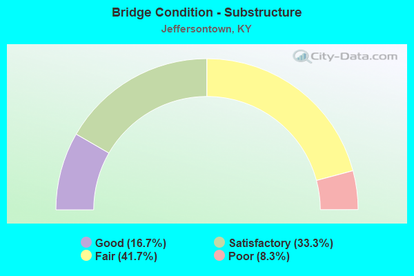
- Bridge Condition - Substructure
- 16.7%Good
- 33.3%Satisfactory
- 41.7%Fair
- 8.3%Poor
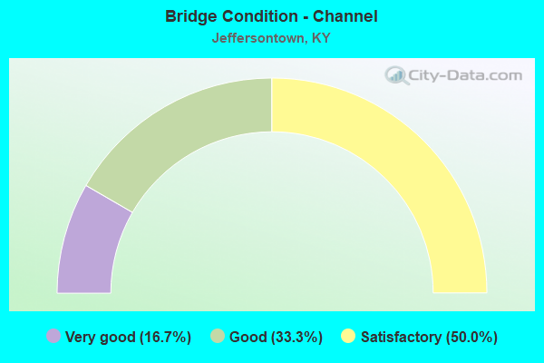
- Bridge Condition - Channel
- 16.7%Very good
- 33.3%Good
- 50.0%Satisfactory
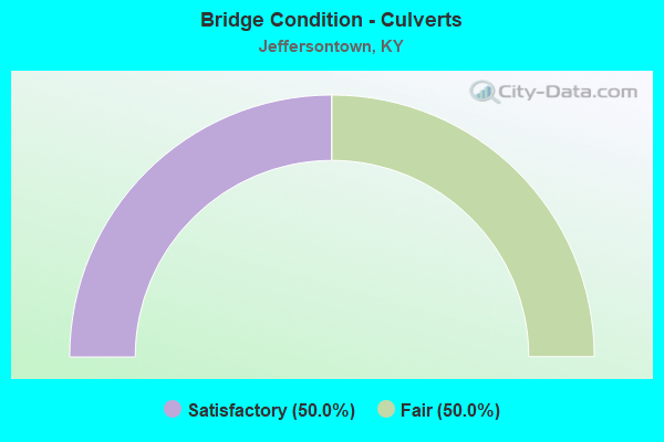
- Bridge Condition - Culverts
- 50.0%Satisfactory
- 50.0%Fair
Find on map >> Show street view
Structure Number: 56B00014N, Location: 1.0 MI N OF WATTERSON TR (Lat: 38.201111, Lng: -85.572500), Route carried "on" structure: State highway 155, Year Built: 1941, Status: Posted for load, Structure Length: 0.65m (2.13ft), Average Daily Traffic: 24,201 (year 2020), Truck Traffic: 9%, Average Future Daily Traffic: 22,748 (year 2040), Design Load: H 15, Features Intersected: BR OF CHENOWETH RUN
Minimum Vertical Clearance: 30+ m (98+ ft), Kilometerpoint: 16.047, Lanes on structure: 4, Base Highway Network: Yes, Owner: State Highway Agency, Approaching Roadway Width: 17.1m (56.1ft), Skew: 3 degrees, Material/Design: Concrete, Design/Construction: Culvert, Number Of Spans In Main Unit: 2, Length of Maximum Span: 3.0m (9.8ft), Curb or Sidewalk Widths: Left: 2.1m (6.9ft), Right: 2.6m (8.5ft), Curb-To-Curb Width: 17.2m (56.4ft), Out-to-Out Width: 21.9m (71.9ft)
Condition: Channel: Satisfactory, Culverts: Satisfactory, Operating Rating: 39.0 metric tons, Method Used To Determine Operating Rating: Field evaluation and documented engineering judgment, Inventory Rating: 18.1 metric tons, Method Used To Determine Inventory Rating: Field evaluation and documented engineering judgment, Structural Evaluation: Meets minimum limits, Deck Geometry: Somewhat better than minimum adequacy, Waterway Adequacy: Somewhat better than minimum adequacy, Approach Roadway Alignment: Equal to present desirable criteria, Bridge Posting: Required (Relationship of Operating Rating to Maximum Legal Load: > 39.9% below), Designated Inspection Frequency: Every 24 months, Inspection Date: November 2020
Find on map >> Show street view
Structure Number: 56B00038L, Location: 0.75 MI W OF KY 913 (Lat: 38.223611, Lng: -85.552500), Route carried "on" structure: Interstate 64, Year Built: 1963, Year Reconstructed: 1988, Status: Open, Structure Length: 4.85m (15.91ft), Average Daily Traffic: 38,465 (year 2020), Truck Traffic: 9%, Average Future Daily Traffic: 41,158 (year 2040), Design Load: HS 20, Features Intersected: KY 1819
Minimum Vertical Clearance: 30+ m (98+ ft), Kilometerpoint: 26.256, Lanes on structure: 3, Lanes under structure: 2, Base Highway Network: Yes, Owner: State Highway Agency, Approaching Roadway Width: 20.1m (65.9ft), Skew: 2 degrees, Material/Design: Concrete, Design/Construction: Tee Beam, Number Of Spans In Main Unit: 3, Length of Maximum Span: 16.2m (53.1ft), Curb-To-Curb Width: 20.1m (65.9ft), Out-to-Out Width: 21.1m (69.2ft)
Condition: Deck: Satisfactory, Superstructure: Good, Substructure: Fair, Operating Rating: 70.9 metric tons, Method Used To Determine Operating Rating: Load Factor (LF), Inventory Rating: 42.5 metric tons, Method Used To Determine Inventory Rating: Load Factor (LF), Structural Evaluation: Somewhat better than minimum adequacy, Deck Geometry: Superior to present desirable criteria, Underclear: Meets minimum limits, Approach Roadway Alignment: Equal to present desirable criteria, Length Of Structure Improvement: 0.48m (1.57ft), Designated Inspection Frequency: Every 24 months, Inspection Date: April 2021, Bridge Improvement Cost: $1,377,000, Total Project Cost: $1,377,000, Deck Structure Type: Concrete Cast-file-Place, Wearing Surface/Protective System: Wearing Surface: Latex Concrete
Find on map >> Show street view
Structure Number: 56B00038R, Location: 0.75 MI W OF KY 913 (Lat: 38.223333, Lng: -85.552500), Route carried "on" structure: Interstate 64, Year Built: 1963, Year Reconstructed: 1988, Status: Open, Structure Length: 4.85m (15.91ft), Average Daily Traffic: 38,465 (year 2020), Truck Traffic: 9%, Average Future Daily Traffic: 41,158 (year 2040), Design Load: HS 20, Features Intersected: KY 1819
Minimum Vertical Clearance: 30+ m (98+ ft), Kilometerpoint: 26.470, Lanes on structure: 4, Lanes under structure: 2, Base Highway Network: Yes, Owner: State Highway Agency, Approaching Roadway Width: 20.1m (65.9ft), Skew: 2 degrees, Material/Design: Concrete, Design/Construction: Tee Beam, Number Of Spans In Main Unit: 3, Length of Maximum Span: 16.2m (53.1ft), Curb-To-Curb Width: 20.1m (65.9ft), Out-to-Out Width: 21.1m (69.2ft)
Condition: Deck: Satisfactory, Superstructure: Satisfactory, Substructure: Fair, Operating Rating: 70.9 metric tons, Method Used To Determine Operating Rating: Load Factor (LF), Inventory Rating: 42.5 metric tons, Method Used To Determine Inventory Rating: Load Factor (LF), Structural Evaluation: Somewhat better than minimum adequacy, Deck Geometry: Equal to present minimum criteria, Underclear: Meets minimum limits, Approach Roadway Alignment: Equal to present desirable criteria, Length Of Structure Improvement: 0.48m (1.57ft), Designated Inspection Frequency: Every 24 months, Inspection Date: April 2021, Bridge Improvement Cost: $1,377,000, Total Project Cost: $1,377,000, Deck Structure Type: Concrete Cast-file-Place, Wearing Surface/Protective System: Wearing Surface: Latex Concrete
Find on map >> Show street view
Structure Number: 56B00040L, Location: 2.6 MI E OF I-264 (Lat: 38.223611, Lng: -85.578889), Route carried "on" structure: Interstate 64, Year Built: 1964, Year Reconstructed: 1988, Status: Open, Structure Length: 5.85m (19.19ft), Average Daily Traffic: 45,758 (year 2020), Truck Traffic: 8%, Average Future Daily Traffic: 48,961 (year 2040), Design Load: HS 20, Features Intersected: KY 1747
Minimum Vertical Clearance: 30+ m (98+ ft), Kilometerpoint: 23.941, Lanes on structure: 3, Lanes under structure: 6, Base Highway Network: Yes, Owner: State Highway Agency, Approaching Roadway Width: 17.7m (58.1ft), Material/Design: Prestressed concrete, Design/Construction: Stringer/Multi-beam, Number Of Spans In Main Unit: 4, Length of Maximum Span: 14.6m (47.9ft), Curb-To-Curb Width: 17.7m (58.1ft), Out-to-Out Width: 18.7m (61.4ft)
Condition: Deck: Satisfactory, Superstructure: Satisfactory, Substructure: Fair, Operating Rating: 63.8 metric tons, Method Used To Determine Operating Rating: Load Factor (LF), Inventory Rating: 38.3 metric tons, Method Used To Determine Inventory Rating: Load Factor (LF), Structural Evaluation: Somewhat better than minimum adequacy, Deck Geometry: Better than present minimum criteria, Underclear: High priority of corrective action, Approach Roadway Alignment: Equal to present desirable criteria, Length Of Structure Improvement: 0.60m (1.97ft), Designated Inspection Frequency: Every 24 months, Inspection Date: April 2021, Bridge Improvement Cost: $1,502,000, Total Project Cost: $1,501,000, Deck Structure Type: Concrete Cast-file-Place, Wearing Surface/Protective System: Wearing Surface: Latex Concrete
Find on map >> Show street view
Structure Number: 56B00040R, Location: 2.6 MI E OF I-264 (Lat: 38.223333, Lng: -85.578889), Route carried "on" structure: Interstate 64, Year Built: 1964, Year Reconstructed: 1988, Status: Open, Structure Length: 5.85m (19.19ft), Average Daily Traffic: 38,465 (year 2020), Truck Traffic: 9%, Average Future Daily Traffic: 41,158 (year 2040), Design Load: HS 20, Features Intersected: KY 1747
Minimum Vertical Clearance: 30+ m (98+ ft), Kilometerpoint: 24.196, Lanes on structure: 3, Lanes under structure: 6, Base Highway Network: Yes, Owner: State Highway Agency, Approaching Roadway Width: 25.4m (83.3ft), Skew: 30 degrees, Material/Design: Prestressed concrete, Design/Construction: Stringer/Multi-beam, Number Of Spans In Main Unit: 4, Length of Maximum Span: 14.6m (47.9ft), Curb-To-Curb Width: 25.4m (83.3ft), Out-to-Out Width: 27.2m (89.2ft)
Condition: Deck: Satisfactory, Superstructure: Satisfactory, Substructure: Fair, Operating Rating: 63.2 metric tons, Method Used To Determine Operating Rating: Load Factor (LF), Inventory Rating: 37.9 metric tons, Method Used To Determine Inventory Rating: Load Factor (LF), Structural Evaluation: Somewhat better than minimum adequacy, Deck Geometry: Superior to present desirable criteria, Underclear: High priority of corrective action, Approach Roadway Alignment: Equal to present desirable criteria, Length Of Structure Improvement: 0.60m (1.97ft), Designated Inspection Frequency: Every 24 months, Inspection Date: April 2021, Bridge Improvement Cost: $2,185,000, Total Project Cost: $2,185,000, Deck Structure Type: Concrete Cast-file-Place, Wearing Surface/Protective System: Wearing Surface: Latex Concrete
Find on map >> Show street view
Structure Number: 56B00349N, Location: 0.15 MI N OF KY 155 (Lat: 38.191944, Lng: -85.559722), Route carried "on" structure: State highway 1819, Year Built: 1985, Status: Open, Structure Length: 0.73m (2.40ft), Average Daily Traffic: 8,969 (year 2016), Truck Traffic: 4%, Average Future Daily Traffic: 8,341 (year 2036), Features Intersected: TRIB TO CHENOWETH RUN
Minimum Vertical Clearance: 30+ m (98+ ft), Kilometerpoint: 15.340, Lanes on structure: 2, Owner: State Highway Agency, Approaching Roadway Width: 12.8m (42.0ft), Skew: 4 degrees, Material/Design: Concrete, Design/Construction: Culvert, Number Of Spans In Main Unit: 2, Length of Maximum Span: 3.4m (11.2ft)
Condition: Channel: Satisfactory, Culverts: Fair, Operating Rating: 54.4 metric tons, Method Used To Determine Operating Rating: Field evaluation and documented engineering judgment, Inventory Rating: 39.9 metric tons, Method Used To Determine Inventory Rating: Field evaluation and documented engineering judgment, Structural Evaluation: Somewhat better than minimum adequacy, Waterway Adequacy: Equal to present desirable criteria, Approach Roadway Alignment: Equal to present desirable criteria, Designated Inspection Frequency: Every 24 months, Inspection Date: November 2020
Find on map >> Show street view
Structure Number: 56B00350N, Location: 0.4 MI N OF KY 155 (Lat: 38.194722, Lng: -85.557222), Route carried "on" structure: State highway 1819, Year Built: 1985, Status: Open, Structure Length: 1.71m (5.61ft), Average Daily Traffic: 8,969 (year 2016), Truck Traffic: 4%, Average Future Daily Traffic: 8,341 (year 2036), Design Load: HS 20, Features Intersected: CHENOWETH RUN
Minimum Vertical Clearance: 30+ m (98+ ft), Kilometerpoint: 15.730, Lanes on structure: 2, Owner: State Highway Agency, Approaching Roadway Width: 9.8m (32.2ft), Skew: 3 degrees, Material/Design: Prestressed concrete, Design/Construction: Box Beam or Girders - Multiple, Number Of Spans In Main Unit: 1, Length of Maximum Span: 16.6m (54.5ft), Curb-To-Curb Width: 9.8m (32.2ft), Out-to-Out Width: 11.0m (36.1ft)
Condition: Deck: Fair, Superstructure: Satisfactory, Substructure: Fair, Channel: Good, Operating Rating: 91.7 metric tons, Method Used To Determine Operating Rating: Load Factor (LF), Inventory Rating: 55.0 metric tons, Method Used To Determine Inventory Rating: Load Factor (LF), Structural Evaluation: Somewhat better than minimum adequacy, Deck Geometry: Meets minimum limits, Waterway Adequacy: Superior to present desirable criteria, Approach Roadway Alignment: Equal to present desirable criteria, Designated Inspection Frequency: Every 24 months, Inspection Date: November 2020, Deck Structure Type: Concrete Cast-file-Place, Wearing Surface/Protective System: Wearing Surface: Monolithic Concrete, Deck Protection: Epoxy Coated Reinforcing
Find on map >> Show street view
Structure Number: 56B00416L, Location: 0.5 MI N OF BLUEGRSS PKWY (Lat: 38.223889, Lng: -85.539167), Route carried "on" structure: State highway 913, Year Built: 1988, Status: Open, Structure Length: 9.64m (31.63ft), Average Daily Traffic: 12,841 (year 2020), Truck Traffic: 4%, Average Future Daily Traffic: 12,070 (year 2040), Design Load: HS 20, Features Intersected: I-64
Minimum Vertical Clearance: 30+ m (98+ ft), Kilometerpoint: 4.559, Lanes on structure: 2, Lanes under structure: 8, Base Highway Network: Yes, Owner: State Highway Agency, Approaching Roadway Width: 12.2m (40.0ft), Skew: 1 degrees, Material/Design: Prestressed concrete continuous, Design/Construction: Stringer/Multi-beam, Number Of Spans In Main Unit: 4, Length of Maximum Span: 31.3m (102.7ft), Curb-To-Curb Width: 12.2m (40.0ft), Out-to-Out Width: 13.2m (43.3ft)
Condition: Deck: Satisfactory, Superstructure: Good, Substructure: Satisfactory, Operating Rating: 63.8 metric tons, Method Used To Determine Operating Rating: Load Factor (LF), Inventory Rating: 38.3 metric tons, Method Used To Determine Inventory Rating: Load Factor (LF), Structural Evaluation: Equal to present minimum criteria, Deck Geometry: Better than present minimum criteria, Underclear: High priority of corrective action, Approach Roadway Alignment: Equal to present desirable criteria, Designated Inspection Frequency: Every 24 months, Inspection Date: April 2021, Deck Structure Type: Concrete Cast-file-Place, Wearing Surface/Protective System: Wearing Surface: Monolithic Concrete, Deck Protection: Epoxy Coated Reinforcing
Find on map >> Show street view
Structure Number: 56B00416R, Location: 0.5 MI N OF BLUEGRSS PKWY (Lat: 38.223889, Lng: -85.539167), Route carried "on" structure: State highway 913, Year Built: 1988, Status: Open, Structure Length: 9.64m (31.63ft), Average Daily Traffic: 26,003 (year 2017), Truck Traffic: 10%, Average Future Daily Traffic: 24,442 (year 2037), Design Load: HS 20, Features Intersected: I-64
Minimum Vertical Clearance: 30+ m (98+ ft), Kilometerpoint: 4.553, Lanes on structure: 2, Lanes under structure: 8, Base Highway Network: Yes, Owner: State Highway Agency, Approaching Roadway Width: 15.5m (50.9ft), Skew: 1 degrees, Material/Design: Prestressed concrete continuous, Design/Construction: Stringer/Multi-beam, Number Of Spans In Main Unit: 4, Length of Maximum Span: 31.3m (102.7ft), Curb-To-Curb Width: 15.5m (50.9ft), Out-to-Out Width: 16.6m (54.5ft)
Condition: Deck: Good, Superstructure: Good, Substructure: Satisfactory, Operating Rating: 58.6 metric tons, Method Used To Determine Operating Rating: Load Factor (LF), Inventory Rating: 35.1 metric tons, Method Used To Determine Inventory Rating: Load Factor (LF), Structural Evaluation: Equal to present minimum criteria, Deck Geometry: Superior to present desirable criteria, Underclear: High priority of corrective action, Approach Roadway Alignment: Equal to present desirable criteria, Length Of Structure Improvement: 0.96m (3.15ft), Designated Inspection Frequency: Every 24 months, Inspection Date: April 2021, Bridge Improvement Cost: $2,105,000, Total Project Cost: $2,105,000, Deck Structure Type: Concrete Cast-file-Place, Wearing Surface/Protective System: Wearing Surface: Monolithic Concrete, Deck Protection: Epoxy Coated Reinforcing
Find on map >> Show street view
Structure Number: 56B00441N, Location: 0.2 MI N OF WATTERSON TR (Lat: 38.201667, Lng: -85.560556), Route carried "on" structure: State highway 1819, Year Built: 1993, Status: Open, Structure Length: 8.74m (28.67ft), Average Daily Traffic: 8,874 (year 2018), Truck Traffic: 13%, Average Future Daily Traffic: 8,252 (year 2038), Design Load: HS 25 or greater, Features Intersected: NS RAILROAD
Minimum Vertical Clearance: 30+ m (98+ ft), Kilometerpoint: 16.649, Lanes on structure: 2, Lanes under structure: 1, Owner: State Highway Agency, Approaching Roadway Width: 11.5m (37.7ft), Skew: 2 degrees, Material/Design: Prestressed concrete continuous, Design/Construction: Stringer/Multi-beam, Number Of Spans In Main Unit: 3, Length of Maximum Span: 32.8m (107.6ft), Curb or Sidewalk Widths: Left: 4.7m (15.4ft), Right: 0.0m, Curb-To-Curb Width: 11.5m (37.7ft), Out-to-Out Width: 18.1m (59.4ft)
Condition: Deck: Satisfactory, Superstructure: Satisfactory, Substructure: Good, Operating Rating: 99.8 metric tons, Method Used To Determine Operating Rating: Load Factor (LF), Inventory Rating: 65.3 metric tons, Method Used To Determine Inventory Rating: Load Factor (LF), Structural Evaluation: Equal to present minimum criteria, Deck Geometry: Meets minimum limits, Underclear: Meets minimum limits, Approach Roadway Alignment: Equal to present desirable criteria, Designated Inspection Frequency: Every 24 months, Inspection Date: November 2020, Deck Structure Type: Concrete Cast-file-Place, Wearing Surface/Protective System: Wearing Surface: Monolithic Concrete, Deck Protection: Epoxy Coated Reinforcing
Find on map >> Show street view
Structure Number: 56B00455N, Location: 2.1 MI S OF I-64 (Lat: 38.197500, Lng: -85.546944), Route carried "on" structure: State highway 913, Year Built: 1997, Status: Posted for load, Structure Length: 7.99m (26.21ft), Average Daily Traffic: 14,859 (year 2020), Truck Traffic: 8%, Average Future Daily Traffic: 13,967 (year 2040), Design Load: HS 25 or greater, Features Intersected: NS RAILROAD
Minimum Vertical Clearance: 30+ m (98+ ft), Kilometerpoint: 1.160, Lanes on structure: 4, Base Highway Network: Yes, Owner: State Highway Agency, Approaching Roadway Width: 17.1m (56.1ft), Skew: 34 degrees, Material/Design: Prestressed concrete continuous, Design/Construction: Stringer/Multi-beam, Number Of Spans In Main Unit: 3, Length of Maximum Span: 30.2m (99.1ft), Curb-To-Curb Width: 17.1m (56.1ft), Out-to-Out Width: 23.0m (75.5ft)
Condition: Deck: Satisfactory, Superstructure: Good, Substructure: Satisfactory, Operating Rating: 49.9 metric tons, Method Used To Determine Operating Rating: Load and Resistance Factor Rating (LRFR) rating reported by rating factor(RF) method using HL-93 loadings, Inventory Rating: 38.6 metric tons, Method Used To Determine Inventory Rating: Load and Resistance Factor Rating (LRFR) rating reported by rating factor(RF) method using HL-93 loadings, Structural Evaluation: Equal to present minimum criteria, Deck Geometry: Somewhat better than minimum adequacy, Underclear: Better than present minimum criteria, Approach Roadway Alignment: Equal to present desirable criteria, Bridge Posting: Required (Relationship of Operating Rating to Maximum Legal Load: 20.0 - 29.9% below), Designated Inspection Frequency: Every 24 months, Inspection Date: November 2020, Deck Structure Type: Concrete Cast-file-Place, Wearing Surface/Protective System: Wearing Surface: Monolithic Concrete, Deck Protection: Epoxy Coated Reinforcing
Find on map >> Show street view
Structure Number: 56C00024N, Location: AT CHENOWETH RUN RD (Lat: 38.192500, Lng: -85.555000), Route carried "on" structure: City street 1119, Year Built: 1930, Status: Posted for load, Structure Length: 1.43m (4.69ft), Average Daily Traffic: 1,256 (year 2006), Average Future Daily Traffic: 2,026 (year 2026), Features Intersected: CHENOWETH RUN, Facility Carried by Structure: OLD TAYLORSVILLE R
Minimum Vertical Clearance: 30+ m (98+ ft), Kilometerpoint: 0.848, Lanes on structure: 1, Owner: City or Municipal Highway Agency, Approaching Roadway Width: 5.2m (17.1ft), Material/Design: Masonry, Design/Construction: Arch - Deck, Number Of Spans In Main Unit: 2, Length of Maximum Span: 6.5m (21.3ft), Curb-To-Curb Width: 5.2m (17.1ft), Out-to-Out Width: 6.2m (20.3ft)
Condition: Superstructure: Satisfactory, Substructure: Satisfactory, Channel: Very good, Operating Rating: 16.3 metric tons, Method Used To Determine Operating Rating: Field evaluation and documented engineering judgment, Inventory Rating: 16.3 metric tons, Method Used To Determine Inventory Rating: Field evaluation and documented engineering judgment, Structural Evaluation: Meets minimum limits, Deck Geometry: High priority of replacement, Waterway Adequacy: Better than present minimum criteria, Approach Roadway Alignment: Equal to present minimum criteria, Bridge Posting: Required (Relationship of Operating Rating to Maximum Legal Load: > 39.9% below), Length Of Structure Improvement: 0.15m (0.49ft), Designated Inspection Frequency: Every 24 months, Inspection Date: December 2021, Bridge Improvement Cost: $126,000, Total Project Cost: $126,000
Find on map >> Show street view
Structure Number: 56C00202N, Location: 250 FT NE OF GRAND AVE (Lat: 38.200833, Lng: -85.561944), Route carried "on" structure: City street 3219, Year Built: 1925, Status: Closed, Structure Length: 0.98m (3.22ft), Average Daily Traffic: 6,705 (year 2006), Truck Traffic: 6%, Average Future Daily Traffic: 2,026 (year 2026), Design Load: H 15, Features Intersected: CHENOWETH RUN, Facility Carried by Structure: ACCESS RD/OLD 1819
Minimum Vertical Clearance: 30+ m (98+ ft), Kilometerpoint: 0.072, Lanes on structure: 2, Owner: City or Municipal Highway Agency, Approaching Roadway Width: 6.1m (20.0ft), Material/Design: Concrete, Design/Construction: Slab, Number Of Spans In Main Unit: 1, Length of Maximum Span: 9.1m (29.9ft), Curb or Sidewalk Widths: Left: 0.3m (1.0ft), Right: 0.3m (1.0ft), Curb-To-Curb Width: 6.4m (21.0ft), Out-to-Out Width: 7.3m (24.0ft)
Condition: Deck: Critical, Superstructure: Critical, Substructure: Poor, Channel: Satisfactory, Waterway Adequacy: Superior to present desirable criteria, Approach Roadway Alignment: Equal to present desirable criteria, Bridge Posting: Required (Relationship of Operating Rating to Maximum Legal Load: > 39.9% below), Length Of Structure Improvement: 0.10m (0.33ft), Designated Inspection Frequency: Every 12 months, Inspection Date: December 2020, Bridge Improvement Cost: $115,000, Total Project Cost: $115,000, Deck Structure Type: Concrete Cast-file-Place, Wearing Surface/Protective System: Wearing Surface: Bituminous
Find on map >> Show street view
Structure Number: 56C00203N, Location: 120 FT W OF KY 1819 (Lat: 38.198889, Lng: -85.559722), Route carried "on" structure: City street 1073, Year Built: 1992, Status: Open, Structure Length: 2.43m (7.97ft), Average Daily Traffic: 10,020 (year 2018), Average Future Daily Traffic: 9,318 (year 2038), Design Load: HS 25 or greater, Features Intersected: CHENOWETH RUN, Facility Carried by Structure: WATTERSON TRL
Minimum Vertical Clearance: 30+ m (98+ ft), Kilometerpoint: 1.077, Lanes on structure: 2, Owner: City or Municipal Highway Agency, Approaching Roadway Width: 16.1m (52.8ft), Material/Design: Prestressed concrete, Design/Construction: Stringer/Multi-beam, Number Of Spans In Main Unit: 1, Length of Maximum Span: 23.6m (77.4ft), Curb-To-Curb Width: 16.1m (52.8ft), Out-to-Out Width: 17.1m (56.1ft)
Condition: Deck: Satisfactory, Superstructure: Good, Substructure: Good, Channel: Good, Operating Rating: 99.8 metric tons, Method Used To Determine Operating Rating: Load Factor (LF), Inventory Rating: 62.8 metric tons, Method Used To Determine Inventory Rating: Load Factor (LF), Structural Evaluation: Better than present minimum criteria, Deck Geometry: Superior to present desirable criteria, Waterway Adequacy: Equal to present desirable criteria, Approach Roadway Alignment: Equal to present desirable criteria, Designated Inspection Frequency: Every 24 months, Inspection Date: December 2021, Deck Structure Type: Concrete Cast-file-Place, Wearing Surface/Protective System: Wearing Surface: Monolithic Concrete, Deck Protection: Epoxy Coated Reinforcing
Find on map >> Show street view
Structure Number: 56B00038L, Location: 0.75 MI W OF KY 913 (Lat: 38.223611, Lng: -85.552500), Route carried "under" structure: State highway 1819, Year Built: 1963, Structure Length: 0. m, Average Daily Traffic: 9,640 (year 2020), Truck Traffic: 13%, Features Intersected: KY 1819, Facility Carried by Structure: I-64 WB
Minimum Vertical Clearance: 4.60m (15.09ft), Kilometerpoint: 19.224, Lanes on structure: 3, Lanes under structure: 2, Material/Design: Concrete, Design/Construction: Tee Beam, Length of Maximum Span: 16.2m (53.1ft)
Find on map >> Show street view
Structure Number: 56B00038R, Location: 0.75 MI W OF KY 913 (Lat: 38.223333, Lng: -85.552500), Route carried "under" structure: State highway 1819, Year Built: 1963, Structure Length: 0. m, Average Daily Traffic: 9,640 (year 2020), Truck Traffic: 13%, Features Intersected: KY 1819, Facility Carried by Structure: I-64 EB
Minimum Vertical Clearance: 4.42m (14.50ft), Kilometerpoint: 19.196, Lanes on structure: 4, Lanes under structure: 2, Material/Design: Concrete, Design/Construction: Tee Beam, Length of Maximum Span: 16.2m (53.1ft)
Find on map >> Show street view
Structure Number: 56B00040L, Location: 2.6 MI E OF I-264 (Lat: 38.223611, Lng: -85.578889), Route carried "under" structure: State highway 1747, Year Built: 1964, Structure Length: 0. m, Average Daily Traffic: 47,984 (year 2018), Truck Traffic: 25%, Features Intersected: KY 1747, Facility Carried by Structure: I-64 WB
Minimum Vertical Clearance: 5.05m (16.57ft), Kilometerpoint: 19.187, Lanes on structure: 3, Lanes under structure: 6, Material/Design: Prestressed concrete, Design/Construction: Stringer/Multi-beam, Length of Maximum Span: 14.6m (47.9ft)
Find on map >> Show street view
Structure Number: 56B00040R, Location: 2.6 MI E OF I-264 (Lat: 38.223333, Lng: -85.578889), Route carried "under" structure: State highway 1747, Year Built: 1964, Structure Length: 0. m, Average Daily Traffic: 52,179 (year 2018), Truck Traffic: 3%, Features Intersected: KY 1747, Facility Carried by Structure: I-64 EB
Minimum Vertical Clearance: 5.03m (16.50ft), Kilometerpoint: 19.156, Lanes on structure: 3, Lanes under structure: 6, Material/Design: Prestressed concrete, Design/Construction: Stringer/Multi-beam, Length of Maximum Span: 14.6m (47.9ft)
Find on map >> Show street view
Structure Number: 56B00416L, Location: 0.5 MI N OF BLUEGRSS PKWY (Lat: 38.223889, Lng: -85.539167), Route carried "under" structure: Interstate 64, Year Built: 1988, Structure Length: 0. m, Average Daily Traffic: 76,930 (year 2020), Truck Traffic: 9%, Features Intersected: I-64, Facility Carried by Structure: KY 913 SB
Minimum Vertical Clearance: 5.28m (17.32ft), Kilometerpoint: 27.629, Lanes on structure: 2, Lanes under structure: 6, Material/Design: Prestressed concrete continuous, Design/Construction: Stringer/Multi-beam, Length of Maximum Span: 31.3m (102.7ft)
Find on map >> Show street view
Structure Number: 56B00416L, Location: 0.5 MI N OF BLUEGRSS PKWY (Lat: 38.223889, Lng: -85.539167), Route carried "under" structure: Ramp Interstate 64, Year Built: 1988, Structure Length: 0. m, Average Daily Traffic: 76,930 (year 2020), Truck Traffic: 9%, Features Intersected: I-64, Facility Carried by Structure: KY 913 SB
Minimum Vertical Clearance: 5.33m (17.49ft), Kilometerpoint: 27.631, Lanes on structure: 2, Lanes under structure: 1, Material/Design: Prestressed concrete continuous, Design/Construction: Stringer/Multi-beam, Length of Maximum Span: 31.3m (102.7ft)
Find on map >> Show street view
Structure Number: 56B00416L, Location: 0.5 MI N OF BLUEGRSS PKWY (Lat: 38.223889, Lng: -85.539167), Route carried "under" structure: Ramp Interstate 64, Year Built: 1988, Structure Length: 0. m, Average Daily Traffic: 76,930 (year 2020), Truck Traffic: 9%, Features Intersected: I-64, Facility Carried by Structure: KY 913 SB
Minimum Vertical Clearance: 5.41m (17.75ft), Kilometerpoint: 27.631, Lanes on structure: 2, Lanes under structure: 1, Material/Design: Prestressed concrete continuous, Design/Construction: Stringer/Multi-beam, Length of Maximum Span: 31.3m (102.7ft)
Find on map >> Show street view
Structure Number: 56B00416R, Location: 0.5 MI N OF BLUEGRSS PKWY (Lat: 38.223889, Lng: -85.539167), Route carried "under" structure: Ramp Interstate 64, Year Built: 1988, Structure Length: 0. m, Average Daily Traffic: 92,860 (year 2019), Truck Traffic: 8%, Features Intersected: I-64, Facility Carried by Structure: KY 913 NB
Minimum Vertical Clearance: 5.87m (19.26ft), Kilometerpoint: 27.647, Lanes on structure: 2, Lanes under structure: 1, Material/Design: Prestressed concrete continuous, Design/Construction: Stringer/Multi-beam, Length of Maximum Span: 31.3m (102.7ft)
Find on map >> Show street view
Structure Number: 56B00416R, Location: 0.5 MI N OF BLUEGRSS PKWY (Lat: 38.223889, Lng: -85.539167), Route carried "under" structure: Interstate 64, Year Built: 1988, Structure Length: 0. m, Average Daily Traffic: 92,860 (year 2019), Truck Traffic: 8%, Features Intersected: I-64, Facility Carried by Structure: KY 913 NB
Minimum Vertical Clearance: 5.69m (18.67ft), Kilometerpoint: 27.647, Lanes on structure: 2, Lanes under structure: 6, Material/Design: Prestressed concrete continuous, Design/Construction: Stringer/Multi-beam, Length of Maximum Span: 31.3m (102.7ft)
Find on map >> Show street view
Structure Number: 56B00416R, Location: 0.5 MI N OF BLUEGRSS PKWY (Lat: 38.223889, Lng: -85.539167), Route carried "under" structure: Ramp Interstate 64, Year Built: 1988, Structure Length: 0. m, Average Daily Traffic: 92,860 (year 2019), Truck Traffic: 8%, Features Intersected: I-64, Facility Carried by Structure: KY 913 NB
Minimum Vertical Clearance: 5.77m (18.93ft), Kilometerpoint: 27.647, Lanes on structure: 2, Lanes under structure: 1, Material/Design: Prestressed concrete continuous, Design/Construction: Stringer/Multi-beam, Length of Maximum Span: 31.3m (102.7ft)
Find on map >> Show street view
Structure Number: 56B00441N, Location: 0.2 MI N OF WATTERSON TR (Lat: 38.201667, Lng: -85.560556), Route carried "under" structure: City street 3219, Year Built: 1993, Structure Length: 0. m, Features Intersected: NS RAILROAD, Facility Carried by Structure: KY 1819
Minimum Vertical Clearance: 7.77m (25.49ft), Kilometerpoint: 0.109, Lanes on structure: 2, Lanes under structure: 1, Material/Design: Prestressed concrete continuous, Design/Construction: Stringer/Multi-beam, Length of Maximum Span: 32.8m (107.6ft)
Find on map >> Show street view
Structure Number: 56R00617N, Location: 300 FT S OF MERIONETH DR (Lat: 38.203056, Lng: -85.576111), Route carried "under" structure: State highway 155, Year Built: 1940, Structure Length: 0. m, Average Daily Traffic: 24,201 (year 2020), Truck Traffic: 9%, Features Intersected: KY 155 (TAYLORSVILLE RD), Facility Carried by Structure: NS RAILROAD
Minimum Vertical Clearance: 4.24m (13.91ft), Kilometerpoint: 16.409, Lanes under structure: 4, Material/Design: Steel, Design/Construction: Girder and Floorbeam System, Length of Maximum Span: 29.0m (95.1ft)