Bridge Statistics for Justice, Oklahoma (OK)
Condition, Traffic, Stress, Structural Evaluation, Project Costs
- National Bridge Inventory (NBI) Statistics
- 17Number of bridges
- 200ft / 60.6mTotal length
- $22,039,000Total costs
- 168,180Total average daily traffic
- 51,120Total average daily truck traffic
- National Bridge Inventory (NBI) Registered Bridges for Justice
- No street view available for this location
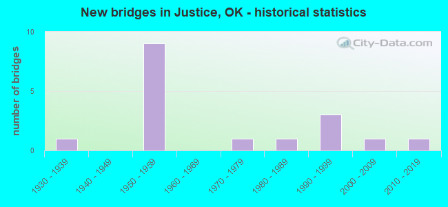
- New bridges - historical statistics
- 11930-1939
- 91950-1959
- 11970-1979
- 11980-1989
- 31990-1999
- 12000-2009
- 12010-2019
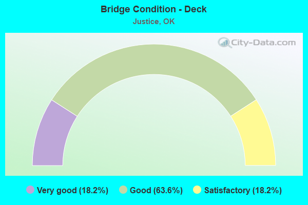
- Bridge Condition - Deck
- 18.2%Very good
- 63.6%Good
- 18.2%Satisfactory
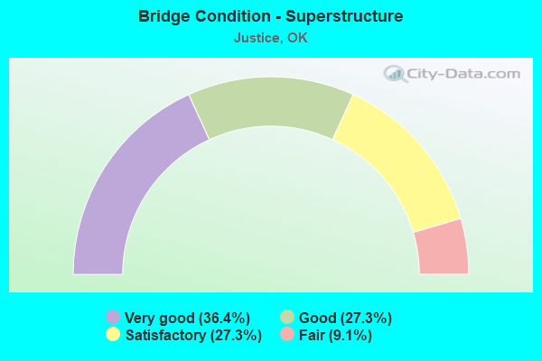
- Bridge Condition - Superstructure
- 36.4%Very good
- 27.3%Good
- 27.3%Satisfactory
- 9.1%Fair
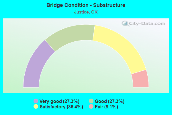
- Bridge Condition - Substructure
- 27.3%Very good
- 27.3%Good
- 36.4%Satisfactory
- 9.1%Fair
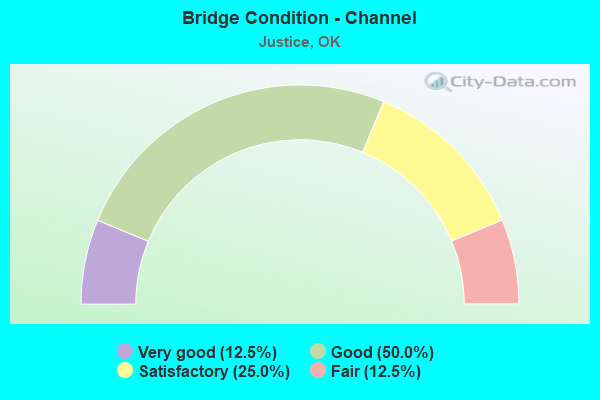
- Bridge Condition - Channel
- 12.5%Very good
- 50.0%Good
- 25.0%Satisfactory
- 12.5%Fair
Find on map >> Show street view
Structure Number: 7133, Location: 1.9 MI S OF SH 20 (Lat: 36.280256, Lng: -95.543147), Route carried "on" structure: County highway N4190, Year Built: 1939, Status: Open, Structure Length: 1.26m (4.13ft), Average Daily Traffic: 375 (year 2020), Truck Traffic: 10%, Average Future Daily Traffic: 600 (year 2040), Features Intersected: DOG CREEK
Minimum Vertical Clearance: 30+ m (98+ ft), Kilometerpoint: 1.448, Lanes on structure: 2, Owner: County Highway Agency, Approaching Roadway Width: 6.1m (20.0ft), Material/Design: Steel continuous, Design/Construction: Stringer/Multi-beam, Number Of Spans In Main Unit: 2, Length of Maximum Span: 5.5m (18.0ft), Curb-To-Curb Width: 5.9m (19.4ft), Out-to-Out Width: 6.6m (21.7ft)
Condition: Deck: Satisfactory, Superstructure: Fair, Substructure: Fair, Channel: Satisfactory, Operating Rating: 88.1 metric tons, Method Used To Determine Operating Rating: Load Factor (LF), Inventory Rating: 52.9 metric tons, Method Used To Determine Inventory Rating: Load Factor (LF), Structural Evaluation: Somewhat better than minimum adequacy, Deck Geometry: High priority of corrective action, Waterway Adequacy: Equal to present desirable criteria, Approach Roadway Alignment: Equal to present minimum criteria, Length Of Structure Improvement: 3.93m (12.89ft), Designated Inspection Frequency: Every 24 months, Inspection Date: July 2021, Bridge Improvement Cost: $201,000, Roadway Improvement Cost: $110,000, Total Project Cost: $319,000 ( Estimate for 2015), Deck Structure Type: Concrete Cast-file-Place, Wearing Surface/Protective System: Wearing Surface: Bituminous
Find on map >> Show street view
Structure Number: 1389, Location: 13.51 MI.NE OF TP GATE (Lat: 36.300833, Lng: -95.591111), Route carried "on" structure: Ramp Other road 44, Year Built: 1957, Year Reconstructed: 1993, Status: Open, Structure Length: 5.39m (17.68ft), Average Daily Traffic: 12,730 (year 2020), Truck Traffic: 16%, Average Future Daily Traffic: 20,368 (year 2040), Design Load: HS 20, Features Intersected: WILL ROGERS TP I-44 UND, Facility Carried by Structure: CLAREMORE INTERCH
Minimum Vertical Clearance: 30+ m (98+ ft), Kilometerpoint: 20.756, Lanes on structure: 2, Lanes under structure: 5, Toll: On toll road, Owner: State Toll Authority, Approaching Roadway Width: 12.2m (40.0ft), Skew: 30 degrees, Material/Design: Steel, Design/Construction: Stringer/Multi-beam, Number Of Spans In Main Unit: 4, Length of Maximum Span: 18.6m (61.0ft), Curb-To-Curb Width: 10.4m (34.1ft), Out-to-Out Width: 12.1m (39.7ft)
Condition: Deck: Good, Superstructure: Good, Substructure: Good, Operating Rating: 44.5 metric tons, Method Used To Determine Operating Rating: Allowable Stress (AS), Inventory Rating: 32.7 metric tons, Method Used To Determine Inventory Rating: Allowable Stress (AS), Structural Evaluation: Better than present minimum criteria, Deck Geometry: Better than present minimum criteria, Underclear: High priority of replacement, Approach Roadway Alignment: Equal to present desirable criteria, Length Of Structure Improvement: 5.39m (17.68ft), Designated Inspection Frequency: Every 24 months, Inspection Date: August 2021, Bridge Improvement Cost: $674,000, Roadway Improvement Cost: $1,011,000, Total Project Cost: $1,928,000 ( Estimate for 2015), Deck Structure Type: Concrete Cast-file-Place, Wearing Surface/Protective System: Wearing Surface: Monolithic Concrete
Find on map >> Show street view
Structure Number: 13992, Location: 13.95 MI.NE OF TP GATE (Lat: 36.305261, Lng: -95.581489), Route carried "on" structure: Interstate 44, Year Built: 1958, Status: Open, Structure Length: 0.88m (2.89ft), Average Daily Traffic: 23,500 (year 2020), Truck Traffic: 36%, Average Future Daily Traffic: 37,600 (year 2040), Design Load: HS 20, Features Intersected: CREEK
Minimum Vertical Clearance: 30+ m (98+ ft), Kilometerpoint: 21.560, Lanes on structure: 4, Base Highway Network: Yes, Toll: On toll road, Owner: State Toll Authority, Approaching Roadway Width: 24.7m (81.0ft), Skew: 33 degrees, Material/Design: Concrete, Design/Construction: Culvert, Number Of Spans In Main Unit: 2, Length of Maximum Span: 3.7m (12.1ft), Curb-To-Curb Width: 43.3m (142.1ft), Out-to-Out Width: 43.9m (144.0ft)
Condition: Channel: Satisfactory, Culverts: Very good, Operating Rating: 44.5 metric tons, Method Used To Determine Operating Rating: Load Factor (LF), Inventory Rating: 32.7 metric tons, Method Used To Determine Inventory Rating: Load Factor (LF), Structural Evaluation: Equal to present desirable criteria, Deck Geometry: Superior to present desirable criteria, Waterway Adequacy: Superior to present desirable criteria, Approach Roadway Alignment: Equal to present desirable criteria, Length Of Structure Improvement: 3.22m (10.56ft), Designated Inspection Frequency: Every 24 months, Inspection Date: August 2021, Bridge Improvement Cost: $200,000, Roadway Improvement Cost: $150,000, Total Project Cost: $360,000 ( Estimate for 2015)
Find on map >> Show street view
Structure Number: 1413, Location: 15.3 MI.NE OF T P GATE (Lat: 36.314444, Lng: -95.560556), Route carried "on" structure: County highway N4180, Year Built: 1958, Status: Open, Structure Length: 4.79m (15.72ft), Average Daily Traffic: 5,000 (year 2020), Truck Traffic: 15%, Average Future Daily Traffic: 8,000 (year 2040), Design Load: H 15, Features Intersected: WILL ROGERS TP I-44 UND
Minimum Vertical Clearance: 30+ m (98+ ft), Kilometerpoint: 24.135, Lanes on structure: 2, Lanes under structure: 4, Owner: State Toll Authority, Approaching Roadway Width: 6.1m (20.0ft), Skew: 3 degrees, Material/Design: Steel, Design/Construction: Stringer/Multi-beam, Number Of Spans In Main Unit: 4, Length of Maximum Span: 13.1m (43.0ft), Curb-To-Curb Width: 5.5m (18.0ft), Out-to-Out Width: 6.6m (21.7ft)
Condition: Deck: Satisfactory, Superstructure: Satisfactory, Substructure: Satisfactory, Operating Rating: 39.9 metric tons, Method Used To Determine Operating Rating: Load Factor (LF), Inventory Rating: 23.6 metric tons, Method Used To Determine Inventory Rating: Load Factor (LF), Structural Evaluation: Equal to present minimum criteria, Deck Geometry: High priority of replacement, Underclear: High priority of replacement, Approach Roadway Alignment: Somewhat better than minimum adequacy, Length Of Structure Improvement: 5.27m (17.29ft), Designated Inspection Frequency: Every 24 months, Inspection Date: August 2021, Bridge Improvement Cost: $598,000, Roadway Improvement Cost: $897,000, Total Project Cost: $1,713,000 ( Estimate for 2015), Deck Structure Type: Concrete Cast-file-Place, Wearing Surface/Protective System: Wearing Surface: Monolithic Concrete
Find on map >> Show street view
Structure Number: 14141, Location: 17.57 MI.NE OF TP GATE (Lat: 36.329722, Lng: -95.525556), Route carried "on" structure: County highway N4200, Year Built: 1958, Status: Open, Structure Length: 5.00m (16.40ft), Average Daily Traffic: 5,000 (year 2020), Truck Traffic: 15%, Average Future Daily Traffic: 8,000 (year 2040), Design Load: H 15, Features Intersected: WILL ROGERS TP I-44 UND
Minimum Vertical Clearance: 30+ m (98+ ft), Kilometerpoint: 28.479, Lanes on structure: 2, Lanes under structure: 4, Owner: State Toll Authority, Approaching Roadway Width: 6.1m (20.0ft), Skew: 2 degrees, Material/Design: Steel, Design/Construction: Stringer/Multi-beam, Number Of Spans In Main Unit: 4, Length of Maximum Span: 13.7m (44.9ft), Curb-To-Curb Width: 5.5m (18.0ft), Out-to-Out Width: 6.6m (21.7ft)
Condition: Deck: Good, Superstructure: Satisfactory, Substructure: Satisfactory, Operating Rating: 33.6 metric tons, Method Used To Determine Operating Rating: Load Factor (LF), Inventory Rating: 20.0 metric tons, Method Used To Determine Inventory Rating: Load Factor (LF), Structural Evaluation: Somewhat better than minimum adequacy, Deck Geometry: High priority of replacement, Underclear: High priority of replacement, Approach Roadway Alignment: Equal to present minimum criteria, Length Of Structure Improvement: 5.00m (16.40ft), Designated Inspection Frequency: Every 24 months, Inspection Date: August 2021, Bridge Improvement Cost: $624,000, Roadway Improvement Cost: $936,000, Total Project Cost: $1,787,000 ( Estimate for 2015), Deck Structure Type: Concrete Cast-file-Place, Wearing Surface/Protective System: Wearing Surface: Monolithic Concrete
Find on map >> Show street view
Structure Number: 14181, Location: 12.8 MI NE OF TP GATE (Lat: 36.296528, Lng: -95.601519), Route carried "on" structure: Interstate 44, Year Built: 1958, Year Reconstructed: 1988, Status: Open, Structure Length: 8.02m (26.31ft), Average Daily Traffic: 23,500 (year 2020), Truck Traffic: 36%, Average Future Daily Traffic: 37,600 (year 2040), Design Load: HS 20, Features Intersected: DOG CREEK
Minimum Vertical Clearance: 30+ m (98+ ft), Kilometerpoint: 19.792, Lanes on structure: 4, Base Highway Network: Yes, Toll: On toll road, Owner: State Toll Authority, Approaching Roadway Width: 24.7m (81.0ft), Skew: 31 degrees, Material/Design: Steel, Design/Construction: Stringer/Multi-beam, Number Of Spans In Main Unit: 5, Length of Maximum Span: 18.3m (60.0ft), Curb-To-Curb Width: 22.6m (74.1ft), Out-to-Out Width: 23.5m (77.1ft)
Condition: Deck: Good, Superstructure: Satisfactory, Substructure: Satisfactory, Channel: Good, Operating Rating: 44.5 metric tons, Method Used To Determine Operating Rating: Allowable Stress (AS), Inventory Rating: 32.7 metric tons, Method Used To Determine Inventory Rating: Allowable Stress (AS), Structural Evaluation: Equal to present minimum criteria, Deck Geometry: Superior to present desirable criteria, Waterway Adequacy: Equal to present desirable criteria, Approach Roadway Alignment: Equal to present desirable criteria, Length Of Structure Improvement: 10.40m (34.12ft), Designated Inspection Frequency: Every 24 months, Inspection Date: August 2021, Bridge Improvement Cost: $1,300,000, Roadway Improvement Cost: $1,950,000, Total Project Cost: $3,704,000 ( Estimate for 2015), Deck Structure Type: Concrete Cast-file-Place, Wearing Surface/Protective System: Wearing Surface: Monolithic Concrete, Deck Protection: Epoxy Coated Reinforcing
Find on map >> Show street view
Structure Number: 1906, Location: 3.8 MI S JCT SH 66 (Lat: 36.271822, Lng: -95.576569), Route carried "on" structure: State highway 88, Year Built: 1975, Status: Open, Structure Length: 4.66m (15.29ft), Average Daily Traffic: 3,700 (year 2020), Truck Traffic: 15%, Average Future Daily Traffic: 5,920 (year 2040), Design Load: HS 20, Features Intersected: PANTHER CREEK
Minimum Vertical Clearance: 30+ m (98+ ft), Kilometerpoint: 21.129, Lanes on structure: 2, Owner: State Highway Agency, Approaching Roadway Width: 13.0m (42.7ft), Skew: 3 degrees, Material/Design: Prestressed concrete, Design/Construction: Stringer/Multi-beam, Number Of Spans In Main Unit: 3, Length of Maximum Span: 15.7m (51.5ft), Curb-To-Curb Width: 13.0m (42.7ft), Out-to-Out Width: 13.9m (45.6ft)
Condition: Deck: Very good, Superstructure: Good, Substructure: Very good, Channel: Very good, Operating Rating: 45.1 metric tons, Method Used To Determine Operating Rating: Load Factor (LF), Inventory Rating: 26.9 metric tons, Method Used To Determine Inventory Rating: Load Factor (LF), Structural Evaluation: Equal to present minimum criteria, Deck Geometry: Equal to present minimum criteria, Waterway Adequacy: Equal to present minimum criteria, Approach Roadway Alignment: Equal to present desirable criteria, Length Of Structure Improvement: 7.80m (25.59ft), Designated Inspection Frequency: Every 24 months, Inspection Date: May 2020, Bridge Improvement Cost: $646,000, Roadway Improvement Cost: $1,067,000, Total Project Cost: $1,810,000 ( Estimate for 2015), Deck Structure Type: Concrete Cast-file-Place, Wearing Surface/Protective System: Wearing Surface: Monolithic Concrete
Find on map >> Show street view
Structure Number: 21078, Location: 2.8 MI S OF I-44 (Lat: 36.282867, Lng: -95.543172), Route carried "on" structure: County highway 6605, Year Built: 1986, Status: Posted for load, Structure Length: 4.66m (15.29ft), Average Daily Traffic: 375 (year 2020), Truck Traffic: 15%, Average Future Daily Traffic: 600 (year 2040), Design Load: HS 20, Features Intersected: PANTHER CREEK
Minimum Vertical Clearance: 30+ m (98+ ft), Kilometerpoint: 1.931, Lanes on structure: 2, Owner: County Highway Agency, Approaching Roadway Width: 6.7m (22.0ft), Skew: 3 degrees, Material/Design: Prestressed concrete, Design/Construction: Stringer/Multi-beam, Number Of Spans In Main Unit: 3, Length of Maximum Span: 15.2m (49.9ft), Curb-To-Curb Width: 9.8m (32.2ft), Out-to-Out Width: 10.7m (35.1ft)
Condition: Deck: Good, Superstructure: Very good, Substructure: Satisfactory, Channel: Good, Operating Rating: 34.2 metric tons, Method Used To Determine Operating Rating: Load Factor (LF), Inventory Rating: 20.5 metric tons, Method Used To Determine Inventory Rating: Load Factor (LF), Structural Evaluation: Somewhat better than minimum adequacy, Deck Geometry: Better than present minimum criteria, Waterway Adequacy: Superior to present desirable criteria, Approach Roadway Alignment: Better than present minimum criteria, Bridge Posting: Required (Relationship of Operating Rating to Maximum Legal Load: 10.0 - 19.9% below), Length Of Structure Improvement: 7.72m (25.33ft), Designated Inspection Frequency: Every 24 months, Inspection Date: July 2021, Bridge Improvement Cost: $394,000, Roadway Improvement Cost: $217,000, Total Project Cost: $612,000 ( Estimate for 2015), Deck Structure Type: Concrete Cast-file-Place, Wearing Surface/Protective System: Wearing Surface: Monolithic Concrete
Find on map >> Show street view
Structure Number: 23673, Location: N4180E0510001 (Lat: 36.277936, Lng: -95.561081), Route carried "on" structure: County highway N4180, Year Built: 1993, Status: Open, Structure Length: 3.75m (12.30ft), Average Daily Traffic: 100 (year 2020), Truck Traffic: 10%, Average Future Daily Traffic: 160 (year 2040), Design Load: HS 20, Features Intersected: DOG CREEK
Minimum Vertical Clearance: 30+ m (98+ ft), Kilometerpoint: 0.161, Lanes on structure: 2, Owner: County Highway Agency, Approaching Roadway Width: 6.7m (22.0ft), Skew: 3 degrees, Material/Design: Prestressed concrete, Design/Construction: Stringer/Multi-beam, Number Of Spans In Main Unit: 3, Length of Maximum Span: 12.2m (40.0ft), Curb-To-Curb Width: 7.9m (25.9ft), Out-to-Out Width: 8.5m (27.9ft)
Condition: Deck: Good, Superstructure: Very good, Substructure: Good, Channel: Good, Operating Rating: 52.3 metric tons, Method Used To Determine Operating Rating: Load Factor (LF), Inventory Rating: 31.3 metric tons, Method Used To Determine Inventory Rating: Load Factor (LF), Structural Evaluation: Better than present minimum criteria, Deck Geometry: Equal to present minimum criteria, Waterway Adequacy: Superior to present desirable criteria, Approach Roadway Alignment: Better than present minimum criteria, Length Of Structure Improvement: 6.95m (22.80ft), Designated Inspection Frequency: Every 24 months, Inspection Date: July 2021, Bridge Improvement Cost: $355,000, Roadway Improvement Cost: $195,000, Total Project Cost: $568,000 ( Estimate for 2015), Deck Structure Type: Concrete Cast-file-Place, Wearing Surface/Protective System: Wearing Surface: Monolithic Concrete
Find on map >> Show street view
Structure Number: 24589, Location: 2.3 MI E JCT SH 66 (Lat: 36.306944, Lng: -95.577222), Route carried "on" structure: State highway 20, Year Built: 1994, Status: Open, Structure Length: 13.29m (43.60ft), Average Daily Traffic: 11,300 (year 2020), Truck Traffic: 16%, Average Future Daily Traffic: 18,080 (year 2040), Design Load: HS 20, Features Intersected: WILL ROGERS TP I-44 UND
Minimum Vertical Clearance: 30+ m (98+ ft), Kilometerpoint: 5.723, Lanes on structure: 4, Lanes under structure: 4, Base Highway Network: Yes, Owner: State Highway Agency, Approaching Roadway Width: 21.9m (71.9ft), Skew: 6 degrees, Material/Design: Prestressed concrete, Design/Construction: Stringer/Multi-beam, Number Of Spans In Main Unit: 4, Length of Maximum Span: 41.1m (134.8ft), Curb-To-Curb Width: 21.9m (71.9ft), Out-to-Out Width: 22.6m (74.1ft)
Condition: Deck: Good, Superstructure: Good, Substructure: Good, Operating Rating: 67.8 metric tons, Method Used To Determine Operating Rating: Load Factor (LF), Inventory Rating: 36.3 metric tons, Method Used To Determine Inventory Rating: Load Factor (LF), Structural Evaluation: Better than present minimum criteria, Deck Geometry: Superior to present desirable criteria, Underclear: Meets minimum limits, Approach Roadway Alignment: Equal to present desirable criteria, Length Of Structure Improvement: 15.48m (50.79ft), Designated Inspection Frequency: Every 24 months, Inspection Date: May 2020, Bridge Improvement Cost: $1,840,000, Roadway Improvement Cost: $3,035,000, Total Project Cost: $5,151,000 ( Estimate for 2015), Deck Structure Type: Concrete Cast-file-Place, Wearing Surface/Protective System: Wearing Surface: Monolithic Concrete, Membrane: Epoxy, Deck Protection: Epoxy Coated Reinforcing
Find on map >> Show street view
Structure Number: 28114, Location: 1S 3.5E JCT SH20/SH88 (Lat: 36.292778, Lng: -95.535000), Route carried "on" structure: County highway E0500, Year Built: 2012, Status: Open, Structure Length: 2.50m (8.20ft), Average Daily Traffic: 100 (year 2020), Truck Traffic: 10%, Average Future Daily Traffic: 160 (year 2040), Design Load: HS 20, Features Intersected: PANTHER CREEK TRIB.
Minimum Vertical Clearance: 30+ m (98+ ft), Kilometerpoint: 0.805, Lanes on structure: 2, Owner: County Highway Agency, Approaching Roadway Width: 9.8m (32.2ft), Material/Design: Prestressed concrete, Design/Construction: Stringer/Multi-beam, Number Of Spans In Main Unit: 1, Length of Maximum Span: 24.4m (80.1ft), Curb-To-Curb Width: 9.9m (32.5ft), Out-to-Out Width: 10.5m (34.4ft)
Condition: Deck: Very good, Superstructure: Very good, Substructure: Very good, Channel: Fair, Operating Rating: 71.7 metric tons, Method Used To Determine Operating Rating: Load Factor (LF), Inventory Rating: 42.6 metric tons, Method Used To Determine Inventory Rating: Load Factor (LF), Structural Evaluation: Equal to present desirable criteria, Deck Geometry: Superior to present desirable criteria, Waterway Adequacy: Equal to present desirable criteria, Approach Roadway Alignment: Equal to present desirable criteria, Designated Inspection Frequency: Every 24 months, Inspection Date: July 2021, Bridge Improvement Cost: $333,000, Roadway Improvement Cost: $111,000, Total Project Cost: $555,000 ( Estimate for 2015), Deck Structure Type: Concrete Cast-file-Place, Wearing Surface/Protective System: Wearing Surface: Monolithic Concrete
Find on map >> Show street view
Structure Number: 28594, Location: 1.5S JCT SH66/SH88 (Lat: 36.294414, Lng: -95.601397), Route carried "on" structure: State highway 88, Year Built: 2007, Status: Open, Structure Length: 6.40m (21.00ft), Average Daily Traffic: 3,600 (year 2020), Truck Traffic: 15%, Average Future Daily Traffic: 5,760 (year 2040), Design Load: HL 93, Features Intersected: DOG CREEK
Minimum Vertical Clearance: 30+ m (98+ ft), Kilometerpoint: 16.525, Lanes on structure: 2, Base Highway Network: Yes, Owner: State Highway Agency, Approaching Roadway Width: 12.2m (40.0ft), Material/Design: Prestressed concrete, Design/Construction: Slab, Number Of Spans In Main Unit: 6, Length of Maximum Span: 10.7m (35.1ft), Curb-To-Curb Width: 12.2m (40.0ft), Out-to-Out Width: 12.8m (42.0ft)
Condition: Deck: Good, Superstructure: Very good, Substructure: Very good, Channel: Good, Operating Rating: 44.5 metric tons, Method Used To Determine Operating Rating: Load and Resistance Factor (LRFR), Inventory Rating: 31.5 metric tons, Method Used To Determine Inventory Rating: Load and Resistance Factor (LRFR), Structural Evaluation: Better than present minimum criteria, Deck Geometry: Equal to present minimum criteria, Waterway Adequacy: Equal to present desirable criteria, Approach Roadway Alignment: Equal to present desirable criteria, Length Of Structure Improvement: 7.04m (23.10ft), Designated Inspection Frequency: Every 24 months, Inspection Date: May 2020, Bridge Improvement Cost: $1,261,000, Roadway Improvement Cost: $2,081,000, Total Project Cost: $3,532,000 ( Estimate for 2015), Deck Structure Type: Concrete Cast-file-Place, Wearing Surface/Protective System: Wearing Surface: Low Slump Concrete, Membrane: Epoxy, Deck Protection: Epoxy Coated Reinforcing
Find on map >> Show street view
Structure Number: 13675, Location: 1.4 MI S JCT. SH 66 (Lat: 36.296164, Lng: -95.602336), Route carried "under" structure: State highway 88, Year Built: 1956, Structure Length: 0. m, Average Daily Traffic: 3,600 (year 2020), Truck Traffic: 15%, Features Intersected: S.H. 88 & UP R.R. UNDER, Facility Carried by Structure: WILL ROGERS TPI-44
Minimum Vertical Clearance: 7.70m (25.26ft), Kilometerpoint: 17.152, Lanes on structure: 4, Lanes under structure: 2, Material/Design: Steel, Design/Construction: Stringer/Multi-beam, Length of Maximum Span: 24.4m (80.1ft)
Find on map >> Show street view
Structure Number: 1389, Location: 13.51 MI.NE OF TP GATE (Lat: 36.300833, Lng: -95.591111), Route carried "under" structure: Interstate 44, Year Built: 1957, Structure Length: 0. m, Average Daily Traffic: 24,900 (year 2020), Truck Traffic: 36%, Features Intersected: WILL ROGERS TP I-44 UND, Facility Carried by Structure: CLAREMORE INTERCH
Minimum Vertical Clearance: 4.75m (15.58ft), Kilometerpoint: 20.756, Lanes on structure: 2, Lanes under structure: 5, Toll: On toll road, Material/Design: Steel, Design/Construction: Stringer/Multi-beam, Length of Maximum Span: 18.6m (61.0ft)
Find on map >> Show street view
Structure Number: 1413, Location: 15.3 MI.NE OF T P GATE (Lat: 36.314444, Lng: -95.560556), Route carried "under" structure: Interstate 44, Year Built: 1958, Structure Length: 0. m, Average Daily Traffic: 16,800 (year 2020), Truck Traffic: 36%, Features Intersected: WILL ROGERS TP I-44 UND, Facility Carried by Structure: CO. RD. N4180
Minimum Vertical Clearance: 4.72m (15.49ft), Kilometerpoint: 23.974, Lanes on structure: 2, Lanes under structure: 4, Toll: On toll road, Material/Design: Steel, Design/Construction: Stringer/Multi-beam, Length of Maximum Span: 13.1m (43.0ft)
Find on map >> Show street view
Structure Number: 14141, Location: 17.57 MI.NE OF TP GATE (Lat: 36.329722, Lng: -95.525556), Route carried "under" structure: Interstate 44, Year Built: 1958, Structure Length: 0. m, Average Daily Traffic: 16,800 (year 2020), Truck Traffic: 36%, Features Intersected: WILL ROGERS TP I-44 UND, Facility Carried by Structure: CO. RD. N4200
Minimum Vertical Clearance: 4.65m (15.26ft), Kilometerpoint: 27.513, Lanes on structure: 2, Lanes under structure: 4, Toll: On toll road, Material/Design: Steel, Design/Construction: Stringer/Multi-beam, Length of Maximum Span: 13.7m (44.9ft)
Find on map >> Show street view
Structure Number: 24589, Location: 2.3 MI E JCT SH 66 (Lat: 36.306944, Lng: -95.577222), Route carried "under" structure: Interstate 44, Year Built: 1994, Structure Length: 0. m, Average Daily Traffic: 16,800 (year 2020), Truck Traffic: 36%, Features Intersected: WILL ROGERS TP I-44 UND, Facility Carried by Structure: S.H. 20
Minimum Vertical Clearance: 5.05m (16.57ft), Kilometerpoint: 35.734, Lanes on structure: 4, Lanes under structure: 4, Toll: On toll road, Material/Design: Prestressed concrete, Design/Construction: Stringer/Multi-beam, Length of Maximum Span: 41.1m (134.8ft)