Bridge Statistics for La Grande, Oregon (OR)
Condition, Traffic, Stress, Structural Evaluation, Project Costs
- National Bridge Inventory (NBI) Statistics
- 41Number of bridges
- 988ft / 301mTotal length
- $11,810,000Total costs
- 205,071Total average daily traffic
- 69,001Total average daily truck traffic
- National Bridge Inventory (NBI) Registered Bridges for La Grande
- No street view available for this location
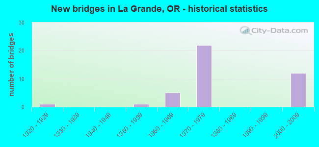
- New bridges - historical statistics
- 11920-1929
- 11950-1959
- 51960-1969
- 221970-1979
- 122000-2009
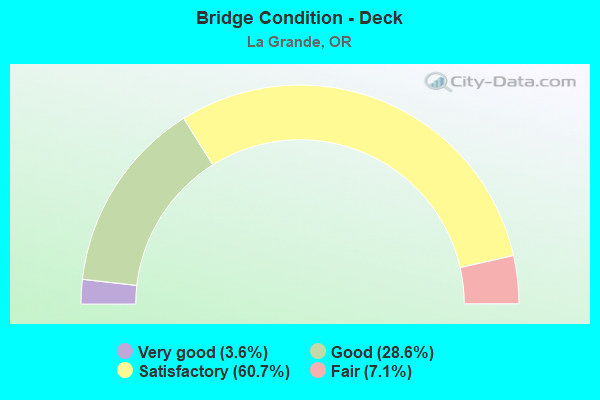
- Bridge Condition - Deck
- 3.6%Very good
- 28.6%Good
- 60.7%Satisfactory
- 7.1%Fair
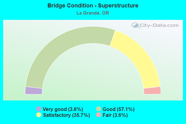
- Bridge Condition - Superstructure
- 3.6%Very good
- 57.1%Good
- 35.7%Satisfactory
- 3.6%Fair
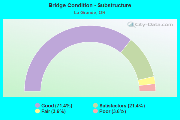
- Bridge Condition - Substructure
- 71.4%Good
- 21.4%Satisfactory
- 3.6%Fair
- 3.6%Poor
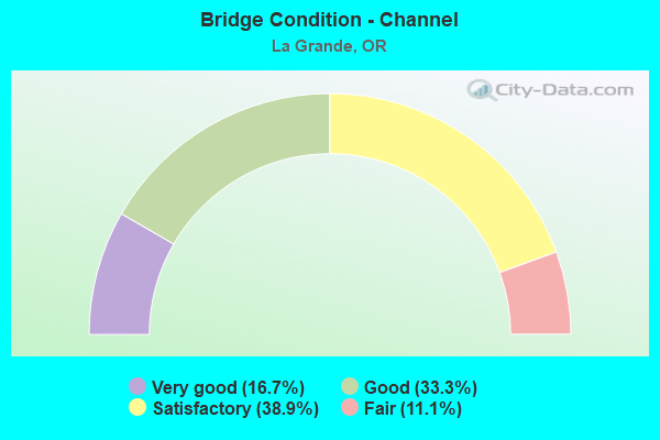
- Bridge Condition - Channel
- 16.7%Very good
- 33.3%Good
- 38.9%Satisfactory
- 11.1%Fair
Find on map >> Show street view
Structure Number: 626 006F25631, Location: 0.1 MI N UPPER PERRY INT (Lat: 45.352633, Lng: -118.170567), Route carried "on" structure: ServiceState highway 84, Year Built: 1924, Year Reconstructed: 2009, Status: Open, Structure Length: 9.51m (31.20ft), Average Daily Traffic: 8 (year 2020), Truck Traffic: 37%, Average Future Daily Traffic: 10 (year 2030), Design Load: H 15, Features Intersected: GRANDE RONDE R AND UPRR
Minimum Vertical Clearance: 30+ m (98+ ft), Kilometerpoint: 412.491, Lanes on structure: 1, Owner: State Highway Agency, Approaching Roadway Width: 6.7m (22.0ft), Material/Design: Concrete continuous, Design/Construction: Arch - Deck, Number Of Spans In Main Unit: 1, Number Of Approach Spans: 4, Length of Maximum Span: 41.1m (134.8ft), Curb-To-Curb Width: 5.9m (19.4ft), Out-to-Out Width: 6.9m (22.6ft)
Condition: Deck: Good, Superstructure: Satisfactory, Substructure: Satisfactory, Channel: Good, Operating Rating: 30.1 metric tons, Method Used To Determine Operating Rating: Load and Resistance Factor Rating (LRFR) rating reported by rating factor(RF) method using HL-93 loadings, Inventory Rating: 23.0 metric tons, Method Used To Determine Inventory Rating: Load and Resistance Factor Rating (LRFR) rating reported by rating factor(RF) method using HL-93 loadings, Structural Evaluation: Equal to present minimum criteria, Deck Geometry: Meets minimum limits, Underclear: Meets minimum limits, Waterway Adequacy: Equal to present desirable criteria, Approach Roadway Alignment: Equal to present minimum criteria, Designated Inspection Frequency: Every 24 months, Inspection Date: May 2020, Deck Structure Type: Concrete Cast-file-Place, Wearing Surface/Protective System: Wearing Surface: Monolithic Concrete
Find on map >> Show street view
Structure Number: 8426 006C25642, Location: 12.4 MI. E UMATILLA CO LN (Lat: 45.349692, Lng: -118.169739), Route carried "on" structure: ServiceInterstate , Year Built: 1960, Status: Open, Structure Length: 5.03m (16.50ft), Average Daily Traffic: 39 (year 2020), Truck Traffic: 43%, Average Future Daily Traffic: 218 (year 2030), Design Load: HS 20, Features Intersected: I-84 (HWY 006), Facility Carried by Structure: U. PERRY I/C CONN
Minimum Vertical Clearance: 30+ m (98+ ft), Kilometerpoint: 412.668, Lanes on structure: 2, Lanes under structure: 4, Owner: State Highway Agency, Approaching Roadway Width: 7.3m (24.0ft), Material/Design: Concrete continuous, Design/Construction: Stringer/Multi-beam, Number Of Spans In Main Unit: 3, Length of Maximum Span: 24.7m (81.0ft), Curb-To-Curb Width: 7.3m (24.0ft), Out-to-Out Width: 8.8m (28.9ft)
Condition: Deck: Satisfactory, Superstructure: Satisfactory, Substructure: Fair, Operating Rating: 35.6 metric tons, Method Used To Determine Operating Rating: Load and Resistance Factor Rating (LRFR) rating reported by rating factor(RF) method using HL-93 loadings, Inventory Rating: 27.5 metric tons, Method Used To Determine Inventory Rating: Load and Resistance Factor Rating (LRFR) rating reported by rating factor(RF) method using HL-93 loadings, Structural Evaluation: Somewhat better than minimum adequacy, Deck Geometry: Equal to present minimum criteria, Underclear: High priority of corrective action, Approach Roadway Alignment: Equal to present minimum criteria, Length Of Structure Improvement: 5.00m (16.40ft), Designated Inspection Frequency: Every 24 months, Inspection Date: May 2020, Bridge Improvement Cost: $489,000, Roadway Improvement Cost: $49,000, Total Project Cost: $783,000, Deck Structure Type: Concrete Cast-file-Place, Wearing Surface/Protective System: Wearing Surface: Epoxy Overlay
Find on map >> Show street view
Structure Number: 8427 006F25675, Location: 3.4 MI NW LAGRANDE (Lat: 45.347350, Lng: -118.166811), Route carried "on" structure: ServiceInterstate 84, Year Built: 1959, Status: Open, Structure Length: 7.80m (25.59ft), Average Daily Traffic: 8 (year 2020), Truck Traffic: 37%, Average Future Daily Traffic: 30 (year 2030), Design Load: HS 20, Features Intersected: GRANDE RONDE RIVER, Facility Carried by Structure: HWY 6 FRONTAGE RD
Minimum Vertical Clearance: 30+ m (98+ ft), Kilometerpoint: 413.199, Lanes on structure: 2, Base Highway Network: Yes, Owner: State Highway Agency, Approaching Roadway Width: 7.3m (24.0ft), Skew: 3 degrees, Material/Design: Concrete continuous, Design/Construction: Tee Beam, Number Of Spans In Main Unit: 4, Length of Maximum Span: 21.6m (70.9ft), Curb-To-Curb Width: 7.9m (25.9ft), Out-to-Out Width: 9.4m (30.8ft)
Condition: Deck: Satisfactory, Superstructure: Satisfactory, Substructure: Satisfactory, Channel: Good, Operating Rating: 45.4 metric tons, Method Used To Determine Operating Rating: Load Factor (LF), Inventory Rating: 27.2 metric tons, Method Used To Determine Inventory Rating: Load Factor (LF), Structural Evaluation: Equal to present minimum criteria, Deck Geometry: Equal to present minimum criteria, Waterway Adequacy: Equal to present desirable criteria, Approach Roadway Alignment: Equal to present minimum criteria, Designated Inspection Frequency: Every 24 months, Underwater Inspection Frequency: Every 60 months, Inspection Date: May 2020, Underwater Inspection Date: September 2018, Deck Structure Type: Concrete Cast-file-Place, Wearing Surface/Protective System: Wearing Surface: Monolithic Concrete
Find on map >> Show street view
Structure Number: 8431 066 00026, Location: 0.3 MI. E. JCT. I-84 (Lat: 45.341856, Lng: -118.117186), Route carried "on" structure: US 30, Year Built: 1960, Status: Open, Structure Length: 20.60m (67.59ft), Average Daily Traffic: 871 (year 2020), Truck Traffic: 16%, Average Future Daily Traffic: 950 (year 2040), Design Load: H 20, Features Intersected: UPRR & GRANDE RONDE R
Minimum Vertical Clearance: 30+ m (98+ ft), Kilometerpoint: 0.370, Lanes on structure: 1, Lanes under structure: 2, Base Highway Network: Yes, Owner: State Highway Agency, Approaching Roadway Width: 7.3m (24.0ft), Material/Design: Concrete continuous, Design/Construction: Box Beam or Girders - Multiple, Number Of Spans In Main Unit: 7, Length of Maximum Span: 32.9m (107.9ft), Curb-To-Curb Width: 6.5m (21.3ft), Out-to-Out Width: 7.5m (24.6ft)
Condition: Deck: Good, Superstructure: Fair, Substructure: Satisfactory, Channel: Good, Operating Rating: 36.3 metric tons, Method Used To Determine Operating Rating: Load Factor (LF), Inventory Rating: 21.8 metric tons, Method Used To Determine Inventory Rating: Load Factor (LF), Structural Evaluation: Somewhat better than minimum adequacy, Deck Geometry: High priority of corrective action, Underclear: Somewhat better than minimum adequacy, Waterway Adequacy: Equal to present desirable criteria, Approach Roadway Alignment: Equal to present desirable criteria, Length Of Structure Improvement: 20.60m (67.59ft), Designated Inspection Frequency: Every 24 months, Inspection Date: September 2021, Bridge Improvement Cost: $2,161,000, Roadway Improvement Cost: $216,000, Total Project Cost: $3,458,000, Deck Structure Type: Concrete Cast-file-Place, Wearing Surface/Protective System: Wearing Surface: Latex Concrete
Find on map >> Show street view
Structure Number: 8431A066 00012, Location: 0.1 MI. E. JCT. I-84 (Lat: 45.341617, Lng: -118.117803), Route carried "on" structure: US 30, Year Built: 1973, Status: Open, Structure Length: 13.72m (45.01ft), Average Daily Traffic: 871 (year 2020), Truck Traffic: 16%, Average Future Daily Traffic: 950 (year 2040), Design Load: HS 20, Features Intersected: UPRR & GRANDE RONDE R
Minimum Vertical Clearance: 30+ m (98+ ft), Kilometerpoint: 0.193, Lanes on structure: 1, Base Highway Network: Yes, Owner: State Highway Agency, Approaching Roadway Width: 7.9m (25.9ft), Material/Design: Prestressed concrete continuous, Design/Construction: Stringer/Multi-beam, Number Of Spans In Main Unit: 3, Number Of Approach Spans: 1, Length of Maximum Span: 39.9m (130.9ft), Curb-To-Curb Width: 8.6m (28.2ft), Out-to-Out Width: 9.3m (30.5ft)
Condition: Deck: Satisfactory, Superstructure: Satisfactory, Substructure: Good, Channel: Very good, Operating Rating: 34.3 metric tons, Method Used To Determine Operating Rating: Load and Resistance Factor Rating (LRFR) rating reported by rating factor(RF) method using HL-93 loadings, Inventory Rating: 26.6 metric tons, Method Used To Determine Inventory Rating: Load and Resistance Factor Rating (LRFR) rating reported by rating factor(RF) method using HL-93 loadings, Structural Evaluation: Equal to present minimum criteria, Deck Geometry: Somewhat better than minimum adequacy, Underclear: Meets minimum limits, Waterway Adequacy: Equal to present desirable criteria, Approach Roadway Alignment: Equal to present desirable criteria, Designated Inspection Frequency: Every 24 months, Inspection Date: September 2021, Deck Structure Type: Concrete Cast-file-Place, Wearing Surface/Protective System: Wearing Surface: Monolithic Concrete
Find on map >> Show street view
Structure Number: 9069A000 00132, Location: 0.3 N US30 LA GRANDE (Lat: 45.333594, Lng: -118.099269), Route carried "on" structure: City street , Year Built: 1979, Status: Open, Structure Length: 11.89m (39.01ft), Average Daily Traffic: 5,933 (year 2020), Truck Traffic: 5%, Average Future Daily Traffic: 6,683 (year 2025), Design Load: HS 20, Features Intersected: UNION PACIFIC RAIL ROAD, Facility Carried by Structure: 2ND ST
Minimum Vertical Clearance: 7.93m (26.02ft), Kilometerpoint: 0.483, Lanes on structure: 2, Owner: City or Municipal Highway Agency, Approaching Roadway Width: 9.8m (32.2ft), Material/Design: Steel continuous, Design/Construction: Box Beam or Girders - Single/Spread, Number Of Spans In Main Unit: 3, Length of Maximum Span: 50.0m (164.0ft), Curb or Sidewalk Widths: Left: 0.0m, Right: 1.8m (5.9ft), Curb-To-Curb Width: 9.7m (31.8ft), Out-to-Out Width: 12.5m (41.0ft)
Condition: Deck: Good, Superstructure: Good, Substructure: Poor, Operating Rating: 24.3 metric tons, Method Used To Determine Operating Rating: Load and Resistance Factor Rating (LRFR) rating reported by rating factor(RF) method using HL-93 loadings, Inventory Rating: 18.8 metric tons, Method Used To Determine Inventory Rating: Load and Resistance Factor Rating (LRFR) rating reported by rating factor(RF) method using HL-93 loadings, Structural Evaluation: Meets minimum limits, Deck Geometry: Meets minimum limits, Underclear: Better than present minimum criteria, Approach Roadway Alignment: Equal to present desirable criteria, Designated Inspection Frequency: Every 24 months, Inspection Date: September 2020, Deck Structure Type: Concrete Cast-file-Place, Wearing Surface/Protective System: Wearing Surface: Bituminous, Membrane: Preformed Fabric
Find on map >> Show street view
Structure Number: 9630 006 26031, Location: 1.1 MI. E. JCT. US 30 (Lat: 45.342528, Lng: -118.098708), Route carried "on" structure: Interstate 84, Year Built: 1972, Status: Open, Structure Length: 9.20m (30.18ft), Average Daily Traffic: 5,209 (year 2020), Truck Traffic: 45%, Average Future Daily Traffic: 7,700 (year 2040), Design Load: HS 20, Features Intersected: GRANDE RONDE RIVER
Minimum Vertical Clearance: 6.38m (20.93ft), Kilometerpoint: 418.896, Lanes on structure: 2, Base Highway Network: Yes, Owner: State Highway Agency, Approaching Roadway Width: 12.8m (42.0ft), Skew: 14 degrees, Material/Design: Concrete continuous, Design/Construction: Box Beam or Girders - Multiple, Number Of Spans In Main Unit: 4, Length of Maximum Span: 24.4m (80.1ft), Curb-To-Curb Width: 12.9m (42.3ft), Out-to-Out Width: 13.6m (44.6ft)
Condition: Deck: Satisfactory, Superstructure: Good, Substructure: Good, Channel: Satisfactory, Operating Rating: 44.4 metric tons, Method Used To Determine Operating Rating: Load and Resistance Factor Rating (LRFR) rating reported by rating factor(RF) method using HL-93 loadings, Inventory Rating: 34.3 metric tons, Method Used To Determine Inventory Rating: Load and Resistance Factor Rating (LRFR) rating reported by rating factor(RF) method using HL-93 loadings, Structural Evaluation: Better than present minimum criteria, Deck Geometry: Superior to present desirable criteria, Waterway Adequacy: Equal to present desirable criteria, Approach Roadway Alignment: Equal to present desirable criteria, Designated Inspection Frequency: Every 24 months, Inspection Date: May 2020, Deck Structure Type: Concrete Cast-file-Place, Wearing Surface/Protective System: Wearing Surface: Latex Concrete
Find on map >> Show street view
Structure Number: 9630A006 2603, Location: 1.1 E. JCT. US 30 (Lat: 45.342203, Lng: -118.098997), Route carried "on" structure: Interstate 84, Year Built: 1972, Status: Open, Structure Length: 9.20m (30.18ft), Average Daily Traffic: 5,209 (year 2020), Truck Traffic: 45%, Average Future Daily Traffic: 7,700 (year 2040), Design Load: HS 20, Features Intersected: GRANDE RONDE RIVER
Minimum Vertical Clearance: 6.38m (20.93ft), Kilometerpoint: 418.896, Lanes on structure: 2, Base Highway Network: Yes, Owner: State Highway Agency, Approaching Roadway Width: 12.8m (42.0ft), Skew: 14 degrees, Material/Design: Concrete continuous, Design/Construction: Box Beam or Girders - Multiple, Number Of Spans In Main Unit: 4, Length of Maximum Span: 24.4m (80.1ft), Curb-To-Curb Width: 12.9m (42.3ft), Out-to-Out Width: 13.6m (44.6ft)
Condition: Deck: Good, Superstructure: Good, Substructure: Good, Channel: Satisfactory, Operating Rating: 44.4 metric tons, Method Used To Determine Operating Rating: Load and Resistance Factor Rating (LRFR) rating reported by rating factor(RF) method using HL-93 loadings, Inventory Rating: 34.3 metric tons, Method Used To Determine Inventory Rating: Load and Resistance Factor Rating (LRFR) rating reported by rating factor(RF) method using HL-93 loadings, Structural Evaluation: Better than present minimum criteria, Deck Geometry: Superior to present desirable criteria, Waterway Adequacy: Equal to present desirable criteria, Approach Roadway Alignment: Equal to present desirable criteria, Designated Inspection Frequency: Every 24 months, Inspection Date: May 2020, Deck Structure Type: Concrete Cast-file-Place, Wearing Surface/Protective System: Wearing Surface: Latex Concrete
Find on map >> Show street view
Structure Number: 9630B006 26029, Location: 1.1 E. JCT. US 30 (Lat: 45.342333, Lng: -118.099214), Route carried "on" structure: City street 4645, Year Built: 1972, Status: Open, Structure Length: 12.19m (39.99ft), Average Daily Traffic: 1,714 (year 2010), Truck Traffic: 20%, Average Future Daily Traffic: 2,404 (year 2030), Design Load: HS 20, Features Intersected: GR RONDE R, HWY 6 260.29, Facility Carried by Structure: N 2ND STREET
Minimum Vertical Clearance: 30+ m (98+ ft), Kilometerpoint: 0.000, Lanes on structure: 2, Lanes under structure: 4, Owner: State Highway Agency, Approaching Roadway Width: 9.8m (32.2ft), Skew: 3 degrees, Material/Design: Concrete continuous, Design/Construction: Box Beam or Girders - Multiple, Number Of Spans In Main Unit: 5, Number Of Approach Spans: 1, Length of Maximum Span: 32.6m (107.0ft), Curb or Sidewalk Widths: Left: 0.0m, Right: 1.5m (4.9ft), Curb-To-Curb Width: 12.2m (40.0ft), Out-to-Out Width: 14.8m (48.6ft)
Condition: Deck: Fair, Superstructure: Satisfactory, Substructure: Satisfactory, Channel: Satisfactory, Operating Rating: 26.2 metric tons, Method Used To Determine Operating Rating: Load and Resistance Factor Rating (LRFR) rating reported by rating factor(RF) method using HL-93 loadings, Inventory Rating: 20.1 metric tons, Method Used To Determine Inventory Rating: Load and Resistance Factor Rating (LRFR) rating reported by rating factor(RF) method using HL-93 loadings, Structural Evaluation: Somewhat better than minimum adequacy, Deck Geometry: Better than present minimum criteria, Underclear: Equal to present minimum criteria, Waterway Adequacy: Equal to present desirable criteria, Approach Roadway Alignment: Equal to present desirable criteria, Designated Inspection Frequency: Every 24 months, Inspection Date: May 2020, Deck Structure Type: Concrete Cast-file-Place, Wearing Surface/Protective System: Wearing Surface: Monolithic Concrete
Find on map >> Show street view
Structure Number: 9631 006 26093, Location: 1.7 E. JCT. US 30 (Lat: 45.340453, Lng: -118.086433), Route carried "on" structure: Interstate 84, Year Built: 1972, Status: Open, Structure Length: 4.60m (15.09ft), Average Daily Traffic: 5,037 (year 2020), Truck Traffic: 45%, Average Future Daily Traffic: 5,300 (year 2040), Design Load: HS 20, Features Intersected: N SPRUCE ST
Minimum Vertical Clearance: 30+ m (98+ ft), Kilometerpoint: 419.926, Lanes on structure: 2, Lanes under structure: 2, Base Highway Network: Yes, Owner: State Highway Agency, Approaching Roadway Width: 12.2m (40.0ft), Skew: 11 degrees, Material/Design: Concrete continuous, Design/Construction: Slab, Number Of Spans In Main Unit: 3, Length of Maximum Span: 22.9m (75.1ft), Curb-To-Curb Width: 12.9m (42.3ft), Out-to-Out Width: 13.6m (44.6ft)
Condition: Deck: Satisfactory, Superstructure: Satisfactory, Substructure: Good, Operating Rating: 27.2 metric tons, Method Used To Determine Operating Rating: Load and Resistance Factor Rating (LRFR) rating reported by rating factor(RF) method using HL-93 loadings, Inventory Rating: 21.1 metric tons, Method Used To Determine Inventory Rating: Load and Resistance Factor Rating (LRFR) rating reported by rating factor(RF) method using HL-93 loadings, Structural Evaluation: Somewhat better than minimum adequacy, Deck Geometry: Superior to present desirable criteria, Underclear: Somewhat better than minimum adequacy, Approach Roadway Alignment: Equal to present desirable criteria, Designated Inspection Frequency: Every 24 months, Inspection Date: May 2020, Deck Structure Type: Concrete Cast-file-Place, Wearing Surface/Protective System: Wearing Surface: Epoxy Overlay
Find on map >> Show street view
Structure Number: 9631A006 26093, Location: 1.7 E. JCT. US 30 (Lat: 45.340075, Lng: -118.086433), Route carried "on" structure: Interstate 84, Year Built: 1972, Status: Open, Structure Length: 4.60m (15.09ft), Average Daily Traffic: 5,037 (year 2020), Truck Traffic: 45%, Average Future Daily Traffic: 5,300 (year 2040), Design Load: HS 20, Features Intersected: N SPRUCE ST
Minimum Vertical Clearance: 30+ m (98+ ft), Kilometerpoint: 419.926, Lanes on structure: 2, Lanes under structure: 2, Base Highway Network: Yes, Owner: State Highway Agency, Approaching Roadway Width: 12.2m (40.0ft), Skew: 11 degrees, Material/Design: Concrete continuous, Design/Construction: Slab, Number Of Spans In Main Unit: 3, Length of Maximum Span: 22.9m (75.1ft), Curb-To-Curb Width: 12.8m (42.0ft), Out-to-Out Width: 13.6m (44.6ft)
Condition: Deck: Satisfactory, Superstructure: Satisfactory, Substructure: Good, Operating Rating: 27.2 metric tons, Method Used To Determine Operating Rating: Load and Resistance Factor Rating (LRFR) rating reported by rating factor(RF) method using HL-93 loadings, Inventory Rating: 21.1 metric tons, Method Used To Determine Inventory Rating: Load and Resistance Factor Rating (LRFR) rating reported by rating factor(RF) method using HL-93 loadings, Structural Evaluation: Somewhat better than minimum adequacy, Deck Geometry: Equal to present desirable criteria, Underclear: Meets minimum limits, Approach Roadway Alignment: Equal to present desirable criteria, Designated Inspection Frequency: Every 24 months, Inspection Date: May 2020, Deck Structure Type: Concrete Cast-file-Place, Wearing Surface/Protective System: Wearing Surface: Epoxy Overlay
Find on map >> Show street view
Structure Number: 9632 006 26185, Location: 2.6 E. JCT. US 30 (Lat: 45.331889, Lng: -118.072361), Route carried "on" structure: Interstate 84, Year Built: 1972, Status: Open, Structure Length: 9.42m (30.91ft), Average Daily Traffic: 5,037 (year 2020), Truck Traffic: 45%, Average Future Daily Traffic: 5,300 (year 2040), Design Load: HS 20, Features Intersected: HWY 10 AND UPRR
Minimum Vertical Clearance: 30+ m (98+ ft), Kilometerpoint: 421.407, Lanes on structure: 3, Lanes under structure: 5, Base Highway Network: Yes, Owner: State Highway Agency, Approaching Roadway Width: 12.2m (40.0ft), Skew: 10 degrees, Material/Design: Steel continuous, Design/Construction: Stringer/Multi-beam, Number Of Spans In Main Unit: 2, Number Of Approach Spans: 1, Length of Maximum Span: 45.7m (149.9ft), Curb-To-Curb Width: 15.2m (49.9ft), Out-to-Out Width: 15.9m (52.2ft)
Condition: Deck: Satisfactory, Superstructure: Good, Substructure: Good, Operating Rating: 35.0 metric tons, Method Used To Determine Operating Rating: Load and Resistance Factor Rating (LRFR) rating reported by rating factor(RF) method using HL-93 loadings, Inventory Rating: 26.9 metric tons, Method Used To Determine Inventory Rating: Load and Resistance Factor Rating (LRFR) rating reported by rating factor(RF) method using HL-93 loadings, Structural Evaluation: Equal to present minimum criteria, Deck Geometry: Meets minimum limits, Underclear: Meets minimum limits, Approach Roadway Alignment: Equal to present desirable criteria, Length Of Structure Improvement: 9.40m (30.84ft), Designated Inspection Frequency: Every 24 months, Critical Feature Inspection Frequency: Every 24 months, Inspection Date: May 2020, Critical Feature Inspection Date: May 2020, Bridge Improvement Cost: $1,679,000, Roadway Improvement Cost: $168,000, Total Project Cost: $2,686,000, Deck Structure Type: Concrete Cast-file-Place, Wearing Surface/Protective System: Wearing Surface: Epoxy Overlay
Find on map >> Show street view
Structure Number: 9632A006 26184, Location: 2.6 E. JCT. US 30 (Lat: 45.331692, Lng: -118.072883), Route carried "on" structure: Interstate 84, Year Built: 1972, Status: Open, Structure Length: 9.36m (30.71ft), Average Daily Traffic: 5,037 (year 2020), Truck Traffic: 45%, Average Future Daily Traffic: 5,300 (year 2040), Design Load: HS 20, Features Intersected: HWY 10 AND UPRR
Minimum Vertical Clearance: 30+ m (98+ ft), Kilometerpoint: 421.391, Lanes on structure: 2, Lanes under structure: 5, Base Highway Network: Yes, Owner: State Highway Agency, Approaching Roadway Width: 12.2m (40.0ft), Skew: 10 degrees, Material/Design: Steel continuous, Design/Construction: Stringer/Multi-beam, Number Of Spans In Main Unit: 2, Number Of Approach Spans: 1, Length of Maximum Span: 45.7m (149.9ft), Curb-To-Curb Width: 12.8m (42.0ft), Out-to-Out Width: 13.8m (45.3ft)
Condition: Deck: Satisfactory, Superstructure: Good, Substructure: Good, Operating Rating: 37.9 metric tons, Method Used To Determine Operating Rating: Load and Resistance Factor Rating (LRFR) rating reported by rating factor(RF) method using HL-93 loadings, Inventory Rating: 29.2 metric tons, Method Used To Determine Inventory Rating: Load and Resistance Factor Rating (LRFR) rating reported by rating factor(RF) method using HL-93 loadings, Structural Evaluation: Better than present minimum criteria, Deck Geometry: Equal to present desirable criteria, Underclear: Meets minimum limits, Approach Roadway Alignment: Equal to present desirable criteria, Length Of Structure Improvement: 9.40m (30.84ft), Designated Inspection Frequency: Every 24 months, Critical Feature Inspection Frequency: Every 24 months, Inspection Date: May 2020, Critical Feature Inspection Date: May 2020, Bridge Improvement Cost: $1,450,000, Roadway Improvement Cost: $145,000, Total Project Cost: $2,321,000, Deck Structure Type: Concrete Cast-file-Place, Wearing Surface/Protective System: Wearing Surface: Epoxy Overlay
Find on map >> Show street view
Structure Number: 9633 006 26234, Location: 0.5 MI. SE JCT. OR 82 (Lat: 45.325797, Lng: -118.066575), Route carried "on" structure: City street , Year Built: 1972, Status: Open, Structure Length: 11.86m (38.91ft), Average Daily Traffic: 8,100 (year 2010), Truck Traffic: 43%, Average Future Daily Traffic: 12,000 (year 2030), Design Load: HS 20, Features Intersected: I-84 (HWY 006), Facility Carried by Structure: COVE AVE
Minimum Vertical Clearance: 30+ m (98+ ft), Kilometerpoint: 422.195, Lanes on structure: 2, Lanes under structure: 4, Owner: State Highway Agency, Approaching Roadway Width: 13.4m (44.0ft), Skew: 3 degrees, Material/Design: Prestressed concrete continuous, Design/Construction: Box Beam or Girders - Multiple, Number Of Spans In Main Unit: 2, Number Of Approach Spans: 2, Length of Maximum Span: 52.4m (171.9ft), Curb-To-Curb Width: 13.4m (44.0ft), Out-to-Out Width: 14.1m (46.3ft)
Condition: Deck: Satisfactory, Superstructure: Satisfactory, Substructure: Good, Operating Rating: 24.6 metric tons, Method Used To Determine Operating Rating: Load and Resistance Factor Rating (LRFR) rating reported by rating factor(RF) method using HL-93 loadings, Inventory Rating: 18.8 metric tons, Method Used To Determine Inventory Rating: Load and Resistance Factor Rating (LRFR) rating reported by rating factor(RF) method using HL-93 loadings, Structural Evaluation: Meets minimum limits, Deck Geometry: Equal to present minimum criteria, Underclear: Better than present minimum criteria, Approach Roadway Alignment: Equal to present desirable criteria, Designated Inspection Frequency: Every 24 months, Inspection Date: June 2020, Deck Structure Type: Concrete Cast-file-Place, Wearing Surface/Protective System: Wearing Surface: Monolithic Concrete
Find on map >> Show street view
Structure Number: 9634 006 26421, Location: 2.4 MI. SE JCT. OR RTE 82 (Lat: 45.304200, Lng: -118.044611), Route carried "on" structure: County highway , Year Built: 1972, Status: Open, Structure Length: 19.08m (62.60ft), Average Daily Traffic: 8,100 (year 2010), Truck Traffic: 43%, Average Future Daily Traffic: 12,000 (year 2030), Design Load: HS 20, Features Intersected: I-84 (HWY 006), Facility Carried by Structure: MCALISTER LANE
Minimum Vertical Clearance: 30+ m (98+ ft), Kilometerpoint: 425.205, Lanes on structure: 2, Lanes under structure: 4, Owner: State Highway Agency, Approaching Roadway Width: 11.0m (36.1ft), Material/Design: Prestressed concrete continuous, Design/Construction: Box Beam or Girders - Multiple, Number Of Spans In Main Unit: 4, Length of Maximum Span: 63.1m (207.0ft), Curb-To-Curb Width: 12.2m (40.0ft), Out-to-Out Width: 13.0m (42.7ft)
Condition: Deck: Satisfactory, Superstructure: Good, Substructure: Good, Operating Rating: 76.1 metric tons, Method Used To Determine Operating Rating: Load and Resistance Factor Rating (LRFR) rating reported by rating factor(RF) method using HL-93 loadings, Inventory Rating: 59.0 metric tons, Method Used To Determine Inventory Rating: Load and Resistance Factor Rating (LRFR) rating reported by rating factor(RF) method using HL-93 loadings, Structural Evaluation: Better than present minimum criteria, Deck Geometry: Somewhat better than minimum adequacy, Underclear: Superior to present desirable criteria, Approach Roadway Alignment: Equal to present desirable criteria, Designated Inspection Frequency: Every 24 months, Inspection Date: June 2020, Deck Structure Type: Concrete Cast-file-Place, Wearing Surface/Protective System: Wearing Surface: Monolithic Concrete
Find on map >> Show street view
Structure Number: 9635 006 26492, Location: 3.1 MI. E. JCT. OR 82 (Lat: 45.294539, Lng: -118.037331), Route carried "on" structure: Interstate 84, Year Built: 1972, Status: Open, Structure Length: 14.90m (48.88ft), Average Daily Traffic: 5,535 (year 2020), Truck Traffic: 36%, Average Future Daily Traffic: 6,500 (year 2040), Design Load: HS 20, Features Intersected: HWY 66, UPRR
Minimum Vertical Clearance: 30+ m (98+ ft), Kilometerpoint: 426.412, Lanes on structure: 2, Lanes under structure: 2, Base Highway Network: Yes, Owner: State Highway Agency, Approaching Roadway Width: 12.2m (40.0ft), Skew: 15 degrees, Material/Design: Steel continuous, Design/Construction: Stringer/Multi-beam, Number Of Spans In Main Unit: 4, Length of Maximum Span: 49.7m (163.1ft), Curb-To-Curb Width: 15.2m (49.9ft), Out-to-Out Width: 16.0m (52.5ft)
Condition: Deck: Satisfactory, Superstructure: Good, Substructure: Good, Operating Rating: 23.7 metric tons, Method Used To Determine Operating Rating: Load and Resistance Factor Rating (LRFR) rating reported by rating factor(RF) method using HL-93 loadings, Inventory Rating: 18.1 metric tons, Method Used To Determine Inventory Rating: Load and Resistance Factor Rating (LRFR) rating reported by rating factor(RF) method using HL-93 loadings, Structural Evaluation: Meets minimum limits, Deck Geometry: Superior to present desirable criteria, Underclear: Superior to present desirable criteria, Approach Roadway Alignment: Equal to present desirable criteria, Designated Inspection Frequency: Every 24 months, Inspection Date: May 2020, Deck Structure Type: Concrete Cast-file-Place, Wearing Surface/Protective System: Wearing Surface: Monolithic Concrete
Find on map >> Show street view
Structure Number: 9635A006 26492, Location: 3.1 MI. E. JCT. OR 82 (Lat: 45.295042, Lng: -118.038072), Route carried "on" structure: Interstate 84, Year Built: 1972, Status: Open, Structure Length: 14.90m (48.88ft), Average Daily Traffic: 5,535 (year 2020), Truck Traffic: 36%, Average Future Daily Traffic: 6,500 (year 2040), Design Load: HS 20, Features Intersected: HWY 66, UPRR
Minimum Vertical Clearance: 30+ m (98+ ft), Kilometerpoint: 426.347, Lanes on structure: 2, Lanes under structure: 3, Base Highway Network: Yes, Owner: State Highway Agency, Approaching Roadway Width: 12.2m (40.0ft), Skew: 15 degrees, Material/Design: Steel continuous, Design/Construction: Stringer/Multi-beam, Number Of Spans In Main Unit: 4, Length of Maximum Span: 49.7m (163.1ft), Curb-To-Curb Width: 12.7m (41.7ft), Out-to-Out Width: 18.1m (59.4ft)
Condition: Deck: Fair, Superstructure: Satisfactory, Substructure: Good, Operating Rating: 16.5 metric tons, Method Used To Determine Operating Rating: Load and Resistance Factor Rating (LRFR) rating reported by rating factor(RF) method using HL-93 loadings, Inventory Rating: 13.0 metric tons, Method Used To Determine Inventory Rating: Load and Resistance Factor Rating (LRFR) rating reported by rating factor(RF) method using HL-93 loadings, Structural Evaluation: High priority of corrective action, Deck Geometry: Better than present minimum criteria, Underclear: Superior to present desirable criteria, Approach Roadway Alignment: Equal to present desirable criteria, Length Of Structure Improvement: 15.20m (49.87ft), Designated Inspection Frequency: Every 24 months, Inspection Date: May 2020, Bridge Improvement Cost: $1,601,000, Roadway Improvement Cost: $160,000, Total Project Cost: $2,562,000, Deck Structure Type: Concrete Cast-file-Place, Wearing Surface/Protective System: Wearing Surface: Monolithic Concrete
Find on map >> Show street view
Structure Number: 10745A010 0011, Location: 1.3 MI N OF HWY 82 (Lat: 45.342361, Lng: -118.086450), Route carried "on" structure: County highway , Year Built: 1965, Status: Open, Structure Length: 7.68m (25.20ft), Average Daily Traffic: 3,803 (year 2020), Truck Traffic: 10%, Average Future Daily Traffic: 4,223 (year 2025), Design Load: HS 20, Features Intersected: GRANDE RONDE RIVER, Facility Carried by Structure: SPRUCE STREET
Minimum Vertical Clearance: 30+ m (98+ ft), Kilometerpoint: 1.770, Lanes on structure: 2, Owner: County Highway Agency, Approaching Roadway Width: 8.5m (27.9ft), Skew: 2 degrees, Material/Design: Concrete continuous, Design/Construction: Box Beam or Girders - Multiple, Number Of Spans In Main Unit: 3, Length of Maximum Span: 30.5m (100.1ft), Curb or Sidewalk Widths: Left: 0.0m, Right: 1.5m (4.9ft), Curb-To-Curb Width: 9.3m (30.5ft), Out-to-Out Width: 12.8m (42.0ft)
Condition: Deck: Good, Superstructure: Satisfactory, Substructure: Satisfactory, Channel: Good, Operating Rating: 89.8 metric tons, Method Used To Determine Operating Rating: Load Factor (LF), Inventory Rating: 59.9 metric tons, Method Used To Determine Inventory Rating: Load Factor (LF), Structural Evaluation: Equal to present minimum criteria, Deck Geometry: Meets minimum limits, Waterway Adequacy: Equal to present desirable criteria, Approach Roadway Alignment: Equal to present desirable criteria, Designated Inspection Frequency: Every 24 months, Inspection Date: September 2020, Deck Structure Type: Concrete Cast-file-Place, Wearing Surface/Protective System: Wearing Surface: Bituminous
Find on map >> Show street view
Structure Number: 19140 023 00058, Location: N OF I-84 FOOTHILL OXING (Lat: 45.255989, Lng: -118.014419), Route carried "on" structure: County highway 23, Year Built: 2001, Status: Open, Structure Length: 0.75m (2.46ft), Average Daily Traffic: 246 (year 2020), Truck Traffic: 2%, Average Future Daily Traffic: 266 (year 2025), Design Load: HS 20, Features Intersected: LADD CREEK, Facility Carried by Structure: PIERCE ROAD
Minimum Vertical Clearance: 30+ m (98+ ft), Kilometerpoint: 0.933, Lanes on structure: 2, Owner: County Highway Agency, Approaching Roadway Width: 7.3m (24.0ft), Material/Design: Steel, Design/Construction: Stringer/Multi-beam, Number Of Spans In Main Unit: 1, Length of Maximum Span: 7.3m (24.0ft), Curb-To-Curb Width: 9.1m (29.9ft), Out-to-Out Width: 9.1m (29.9ft)
Condition: Deck: Good, Superstructure: Good, Substructure: Good, Channel: Good, Operating Rating: 89.8 metric tons, Method Used To Determine Operating Rating: Load Factor (LF), Inventory Rating: 60.8 metric tons, Method Used To Determine Inventory Rating: Load Factor (LF), Structural Evaluation: Better than present minimum criteria, Deck Geometry: Equal to present minimum criteria, Waterway Adequacy: Better than present minimum criteria, Approach Roadway Alignment: Equal to present desirable criteria, Designated Inspection Frequency: Every 24 months, Inspection Date: September 2021, Deck Structure Type: Corrugated Steel, Wearing Surface/Protective System: Wearing Surface: Gravel
Find on map >> Show street view
Structure Number: 19229 006 25724, Location: 13.2 MI SE UMATILLA CO LN (Lat: 45.346000, Lng: -118.156600), Route carried "on" structure: Interstate 84, Year Built: 2003, Status: Open, Structure Length: 13.06m (42.85ft), Average Daily Traffic: 5,722 (year 2020), Truck Traffic: 45%, Average Future Daily Traffic: 6,450 (year 2040), Design Load: HL 93, Features Intersected: GR RONDE R (L PERRY I/C)
Minimum Vertical Clearance: 30+ m (98+ ft), Kilometerpoint: 413.988, Lanes on structure: 2, Lanes under structure: 2, Base Highway Network: Yes, Owner: State Highway Agency, Approaching Roadway Width: 11.9m (39.0ft), Material/Design: Prestressed concrete continuous, Design/Construction: Stringer/Multi-beam, Number Of Spans In Main Unit: 3, Length of Maximum Span: 46.9m (153.9ft), Curb-To-Curb Width: 11.8m (38.7ft), Out-to-Out Width: 12.6m (41.3ft)
Condition: Deck: Good, Superstructure: Good, Substructure: Good, Channel: Fair, Operating Rating: 28.2 metric tons, Method Used To Determine Operating Rating: Load and Resistance Factor Rating (LRFR) rating reported by rating factor(RF) method using HL-93 loadings, Inventory Rating: 21.7 metric tons, Method Used To Determine Inventory Rating: Load and Resistance Factor Rating (LRFR) rating reported by rating factor(RF) method using HL-93 loadings, Structural Evaluation: Somewhat better than minimum adequacy, Deck Geometry: Equal to present minimum criteria, Underclear: Equal to present minimum criteria, Waterway Adequacy: Equal to present desirable criteria, Approach Roadway Alignment: Equal to present desirable criteria, Designated Inspection Frequency: Every 24 months, Inspection Date: September 2021, Deck Structure Type: Concrete Cast-file-Place, Wearing Surface/Protective System: Wearing Surface: Monolithic Concrete, Deck Protection: Epoxy Coated Reinforcing
Find on map >> Show street view
Structure Number: 19230 006 25724, Location: 13.2 MI SE UMATILLA CO LN (Lat: 45.346200, Lng: -118.156600), Route carried "on" structure: Interstate 84, Year Built: 2003, Status: Open, Structure Length: 13.06m (42.85ft), Average Daily Traffic: 5,722 (year 2020), Truck Traffic: 45%, Average Future Daily Traffic: 6,450 (year 2040), Design Load: HL 93, Features Intersected: GR RONDE R (L PERRY I/C)
Minimum Vertical Clearance: 30+ m (98+ ft), Kilometerpoint: 413.955, Lanes on structure: 2, Lanes under structure: 2, Base Highway Network: Yes, Owner: State Highway Agency, Approaching Roadway Width: 11.9m (39.0ft), Material/Design: Prestressed concrete continuous, Design/Construction: Stringer/Multi-beam, Number Of Spans In Main Unit: 3, Length of Maximum Span: 46.9m (153.9ft), Curb-To-Curb Width: 11.8m (38.7ft), Out-to-Out Width: 12.6m (41.3ft)
Condition: Deck: Good, Superstructure: Good, Substructure: Good, Channel: Fair, Operating Rating: 22.4 metric tons, Method Used To Determine Operating Rating: Load and Resistance Factor Rating (LRFR) rating reported by rating factor(RF) method using HL-93 loadings, Inventory Rating: 17.2 metric tons, Method Used To Determine Inventory Rating: Load and Resistance Factor Rating (LRFR) rating reported by rating factor(RF) method using HL-93 loadings, Structural Evaluation: Meets minimum limits, Deck Geometry: Equal to present minimum criteria, Underclear: Equal to present minimum criteria, Waterway Adequacy: Equal to present desirable criteria, Approach Roadway Alignment: Equal to present desirable criteria, Designated Inspection Frequency: Every 24 months, Inspection Date: September 2021, Deck Structure Type: Concrete Cast-file-Place, Wearing Surface/Protective System: Wearing Surface: Monolithic Concrete, Deck Protection: Epoxy Coated Reinforcing
Find on map >> Show street view
Structure Number: 19681 006 25913, Location: 15.1 MI SE UMATILLA CO LN (Lat: 45.343969, Lng: -118.121669), Route carried "on" structure: Interstate 84, Year Built: 2003, Status: Open, Structure Length: 12.55m (41.17ft), Average Daily Traffic: 5,209 (year 2020), Truck Traffic: 45%, Average Future Daily Traffic: 7,700 (year 2040), Design Load: HL 93, Features Intersected: GRANDE RONDE R AND UPRR
Minimum Vertical Clearance: 30+ m (98+ ft), Kilometerpoint: 417.029, Lanes on structure: 2, Base Highway Network: Yes, Owner: State Highway Agency, Approaching Roadway Width: 12.8m (42.0ft), Skew: 14 degrees, Material/Design: Prestressed concrete continuous, Design/Construction: Stringer/Multi-beam, Number Of Spans In Main Unit: 3, Number Of Approach Spans: 2, Length of Maximum Span: 42.5m (139.4ft), Curb-To-Curb Width: 12.6m (41.3ft), Out-to-Out Width: 13.4m (44.0ft)
Condition: Deck: Satisfactory, Superstructure: Good, Substructure: Satisfactory, Channel: Satisfactory, Operating Rating: 74.4 metric tons, Method Used To Determine Operating Rating: Load Factor (LF), Inventory Rating: 44.5 metric tons, Method Used To Determine Inventory Rating: Load Factor (LF), Structural Evaluation: Equal to present minimum criteria, Deck Geometry: Better than present minimum criteria, Underclear: Equal to present minimum criteria, Waterway Adequacy: Equal to present desirable criteria, Approach Roadway Alignment: Equal to present desirable criteria, Designated Inspection Frequency: Every 24 months, Inspection Date: May 2020, Deck Structure Type: Concrete Cast-file-Place, Wearing Surface/Protective System: Wearing Surface: Monolithic Concrete, Deck Protection: Epoxy Coated Reinforcing
Find on map >> Show street view
Structure Number: 19682 006 25913, Location: 15.1 MI SE UMATILLA CO LN (Lat: 45.344500, Lng: -118.121600), Route carried "on" structure: Interstate 84, Year Built: 2004, Status: Open, Structure Length: 14.81m (48.59ft), Average Daily Traffic: 5,209 (year 2020), Truck Traffic: 45%, Average Future Daily Traffic: 7,700 (year 2040), Design Load: HL 93, Features Intersected: GRANDE RONDE R AND UPRR
Minimum Vertical Clearance: 30+ m (98+ ft), Kilometerpoint: 417.029, Lanes on structure: 3, Base Highway Network: Yes, Owner: State Highway Agency, Approaching Roadway Width: 16.2m (53.1ft), Skew: 14 degrees, Material/Design: Prestressed concrete continuous, Design/Construction: Stringer/Multi-beam, Number Of Spans In Main Unit: 3, Number Of Approach Spans: 2, Length of Maximum Span: 46.3m (151.9ft), Curb-To-Curb Width: 16.2m (53.1ft), Out-to-Out Width: 17.0m (55.8ft)
Condition: Deck: Satisfactory, Superstructure: Good, Substructure: Good, Channel: Good, Operating Rating: 83.5 metric tons, Method Used To Determine Operating Rating: Load Factor (LF), Inventory Rating: 49.9 metric tons, Method Used To Determine Inventory Rating: Load Factor (LF), Structural Evaluation: Better than present minimum criteria, Deck Geometry: Equal to present minimum criteria, Underclear: Equal to present minimum criteria, Waterway Adequacy: Better than present minimum criteria, Approach Roadway Alignment: Equal to present desirable criteria, Designated Inspection Frequency: Every 24 months, Inspection Date: May 2020, Deck Structure Type: Concrete Cast-file-Place, Wearing Surface/Protective System: Wearing Surface: Monolithic Concrete, Deck Protection: Epoxy Coated Reinforcing
Find on map >> Show street view
Structure Number: 19683 006 25889, Location: 14.9 MI SE UMATILLA CO LN (Lat: 45.346200, Lng: -118.125300), Route carried "on" structure: Interstate 84, Year Built: 2004, Status: Open, Structure Length: 11.43m (37.50ft), Average Daily Traffic: 5,209 (year 2020), Truck Traffic: 45%, Average Future Daily Traffic: 7,700 (year 2040), Design Load: HL 93, Features Intersected: GRANDE RONDE RIVER
Minimum Vertical Clearance: 30+ m (98+ ft), Kilometerpoint: 416.643, Lanes on structure: 2, Base Highway Network: Yes, Owner: State Highway Agency, Approaching Roadway Width: 11.6m (38.1ft), Material/Design: Prestressed concrete continuous, Design/Construction: Stringer/Multi-beam, Number Of Spans In Main Unit: 2, Number Of Approach Spans: 2, Length of Maximum Span: 44.8m (147.0ft), Curb-To-Curb Width: 12.5m (41.0ft), Out-to-Out Width: 13.4m (44.0ft)
Condition: Deck: Satisfactory, Superstructure: Very good, Substructure: Good, Channel: Satisfactory, Operating Rating: 68.9 metric tons, Method Used To Determine Operating Rating: Load Factor (LF), Inventory Rating: 41.7 metric tons, Method Used To Determine Inventory Rating: Load Factor (LF), Structural Evaluation: Better than present minimum criteria, Deck Geometry: Better than present minimum criteria, Waterway Adequacy: Better than present minimum criteria, Approach Roadway Alignment: Equal to present desirable criteria, Designated Inspection Frequency: Every 24 months, Underwater Inspection Frequency: Every 60 months, Inspection Date: May 2020, Underwater Inspection Date: September 2018, Deck Structure Type: Concrete Cast-file-Place, Wearing Surface/Protective System: Wearing Surface: Monolithic Concrete, Deck Protection: Epoxy Coated Reinforcing
Find on map >> Show street view
Structure Number: 19684 006 25889, Location: 14.9 MI SE UMATILLA CO LN (Lat: 45.346008, Lng: -118.125339), Route carried "on" structure: Interstate 84, Year Built: 2003, Status: Open, Structure Length: 12.98m (42.59ft), Average Daily Traffic: 5,209 (year 2020), Truck Traffic: 45%, Average Future Daily Traffic: 7,700 (year 2040), Design Load: HL 93, Features Intersected: GRANDE RONDE RIVER
Minimum Vertical Clearance: 30+ m (98+ ft), Kilometerpoint: 416.643, Lanes on structure: 2, Base Highway Network: Yes, Owner: State Highway Agency, Approaching Roadway Width: 12.8m (42.0ft), Skew: 1 degrees, Material/Design: Prestressed concrete continuous, Design/Construction: Stringer/Multi-beam, Number Of Spans In Main Unit: 3, Number Of Approach Spans: 1, Length of Maximum Span: 45.0m (147.6ft), Curb-To-Curb Width: 12.6m (41.3ft), Out-to-Out Width: 13.4m (44.0ft)
Condition: Deck: Satisfactory, Superstructure: Good, Substructure: Good, Channel: Satisfactory, Operating Rating: 59.9 metric tons, Method Used To Determine Operating Rating: Load Factor (LF), Inventory Rating: 36.3 metric tons, Method Used To Determine Inventory Rating: Load Factor (LF), Structural Evaluation: Better than present minimum criteria, Deck Geometry: Better than present minimum criteria, Waterway Adequacy: Equal to present desirable criteria, Approach Roadway Alignment: Better than present minimum criteria, Designated Inspection Frequency: Every 24 months, Underwater Inspection Frequency: Every 60 months, Inspection Date: May 2020, Underwater Inspection Date: September 2018, Deck Structure Type: Concrete Cast-file-Place, Wearing Surface/Protective System: Wearing Surface: Monolithic Concrete, Deck Protection: Epoxy Coated Reinforcing
Find on map >> Show street view
Structure Number: 19865 006 25617, Location: 12.2 MI SE UMATILLA CO LN (Lat: 45.352131, Lng: -118.172239), Route carried "on" structure: Interstate 84, Year Built: 2004, Status: Open, Structure Length: 12.86m (42.19ft), Average Daily Traffic: 5,637 (year 2020), Truck Traffic: 45%, Average Future Daily Traffic: 6,350 (year 2040), Design Load: HS 25 or greater, Features Intersected: GRANDE RONDE RIVER
Minimum Vertical Clearance: 30+ m (98+ ft), Kilometerpoint: 412.266, Lanes on structure: 2, Base Highway Network: Yes, Owner: State Highway Agency, Approaching Roadway Width: 12.2m (40.0ft), Skew: 9 degrees, Material/Design: Steel continuous, Design/Construction: Stringer/Multi-beam, Number Of Spans In Main Unit: 2, Length of Maximum Span: 73.2m (240.2ft), Curb-To-Curb Width: 12.2m (40.0ft), Out-to-Out Width: 13.1m (43.0ft)
Condition: Deck: Satisfactory, Superstructure: Good, Substructure: Good, Channel: Very good, Operating Rating: 36.0 metric tons, Method Used To Determine Operating Rating: Load and Resistance Factor Rating (LRFR) rating reported by rating factor(RF) method using HL-93 loadings, Inventory Rating: 27.9 metric tons, Method Used To Determine Inventory Rating: Load and Resistance Factor Rating (LRFR) rating reported by rating factor(RF) method using HL-93 loadings, Structural Evaluation: Better than present minimum criteria, Deck Geometry: Better than present minimum criteria, Waterway Adequacy: Equal to present desirable criteria, Approach Roadway Alignment: Equal to present desirable criteria, Designated Inspection Frequency: Every 24 months, Inspection Date: May 2020, Deck Structure Type: Concrete Cast-file-Place, Wearing Surface/Protective System: Wearing Surface: Monolithic Concrete, Deck Protection: Epoxy Coated Reinforcing
Find on map >> Show street view
Structure Number: 19866 006 25618, Location: 12.2 MI SE UMATILLA CO LN (Lat: 45.352281, Lng: -118.172150), Route carried "on" structure: Interstate 84, Year Built: 2005, Status: Open, Structure Length: 13.29m (43.60ft), Average Daily Traffic: 5,637 (year 2020), Truck Traffic: 45%, Average Future Daily Traffic: 6,350 (year 2040), Design Load: HS 25 or greater, Features Intersected: GRANDE RONDE RIVER
Minimum Vertical Clearance: 30+ m (98+ ft), Kilometerpoint: 412.282, Lanes on structure: 3, Base Highway Network: Yes, Owner: State Highway Agency, Approaching Roadway Width: 14.6m (47.9ft), Skew: 2 degrees, Material/Design: Steel continuous, Design/Construction: Stringer/Multi-beam, Number Of Spans In Main Unit: 2, Length of Maximum Span: 77.3m (253.6ft), Curb-To-Curb Width: 14.6m (47.9ft), Out-to-Out Width: 15.5m (50.9ft)
Condition: Deck: Satisfactory, Superstructure: Good, Substructure: Good, Channel: Very good, Operating Rating: 30.1 metric tons, Method Used To Determine Operating Rating: Load and Resistance Factor Rating (LRFR) rating reported by rating factor(RF) method using HL-93 loadings, Inventory Rating: 23.3 metric tons, Method Used To Determine Inventory Rating: Load and Resistance Factor Rating (LRFR) rating reported by rating factor(RF) method using HL-93 loadings, Structural Evaluation: Somewhat better than minimum adequacy, Deck Geometry: Meets minimum limits, Waterway Adequacy: Equal to present desirable criteria, Approach Roadway Alignment: Equal to present desirable criteria, Designated Inspection Frequency: Every 24 months, Inspection Date: May 2020, Deck Structure Type: Concrete Cast-file-Place, Wearing Surface/Protective System: Wearing Surface: Monolithic Concrete, Deck Protection: Epoxy Coated Reinforcing
Find on map >> Show street view
Structure Number: 21059 023, Location: ON LADD CREEK ROAD (Lat: 45.267714, Lng: -118.014300), Route carried "on" structure: County highway 23, Year Built: 2009, Status: Open, Structure Length: 0.73m (2.40ft), Average Daily Traffic: 246 (year 2020), Truck Traffic: 2%, Average Future Daily Traffic: 261 (year 2025), Design Load: HS 20, Features Intersected: LADD CREEK, Facility Carried by Structure: PIERCE ROAD
Minimum Vertical Clearance: 30+ m (98+ ft), Kilometerpoint: 0.000, Lanes on structure: 2, Owner: County Highway Agency, Approaching Roadway Width: 6.7m (22.0ft), Material/Design: Steel, Design/Construction: Stringer/Multi-beam, Number Of Spans In Main Unit: 1, Length of Maximum Span: 7.0m (23.0ft), Curb-To-Curb Width: 9.0m (29.5ft), Out-to-Out Width: 9.1m (29.9ft)
Condition: Deck: Very good, Superstructure: Good, Substructure: Good, Channel: Satisfactory, Operating Rating: 61.7 metric tons, Method Used To Determine Operating Rating: Load Factor (LF), Inventory Rating: 37.2 metric tons, Method Used To Determine Inventory Rating: Load Factor (LF), Structural Evaluation: Better than present minimum criteria, Deck Geometry: Equal to present minimum criteria, Waterway Adequacy: Equal to present desirable criteria, Approach Roadway Alignment: Equal to present desirable criteria, Designated Inspection Frequency: Every 24 months, Inspection Date: September 2021, Deck Structure Type: Corrugated Steel, Wearing Surface/Protective System: Wearing Surface: Gravel
Find on map >> Show street view
Structure Number: 8426 006C25642, Location: 12.4 MI. E UMATILLA CO LN (Lat: 45.349692, Lng: -118.169739), Route carried "under" structure: Interstate 84, Year Built: 1960, Structure Length: 0. m, Average Daily Traffic: 11,275 (year 2020), Truck Traffic: 45%, Features Intersected: I-84 (HWY 006), Facility Carried by Structure: U. PERRY I/C CONN
Minimum Vertical Clearance: 5.54m (18.18ft), Kilometerpoint: 412.668, Lanes on structure: 2, Lanes under structure: 4, Material/Design: Concrete continuous, Design/Construction: Stringer/Multi-beam, Length of Maximum Span: 24.7m (81.0ft)
Find on map >> Show street view
Structure Number: 8431 066 00026, Location: 0.3 MI. E. JCT. I-84 (Lat: 45.341856, Lng: -118.117186), Route carried "under" structure: Interstate 84, Year Built: 1960, Structure Length: 0. m, Average Daily Traffic: 5,209 (year 2020), Truck Traffic: 45%, Features Intersected: UPRR & GRANDE RONDE R, Facility Carried by Structure: US 30 (HWY 066) WB
Minimum Vertical Clearance: 7.54m (24.74ft), Kilometerpoint: 417.383, Lanes on structure: 1, Lanes under structure: 2, Material/Design: Concrete continuous, Design/Construction: Box Beam or Girders - Multiple, Length of Maximum Span: 32.9m (107.9ft)
Find on map >> Show street view
Structure Number: 9630B006 26029, Location: 1.1 E. JCT. US 30 (Lat: 45.342333, Lng: -118.099214), Route carried "under" structure: Interstate 84, Year Built: 1972, Structure Length: 0. m, Average Daily Traffic: 10,418 (year 2020), Truck Traffic: 45%, Features Intersected: GR RONDE R, HWY 6 260.29, Facility Carried by Structure: N 2ND STREET
Minimum Vertical Clearance: 6.00m (19.69ft), Kilometerpoint: 418.896, Lanes on structure: 2, Lanes under structure: 4, Material/Design: Concrete continuous, Design/Construction: Box Beam or Girders - Multiple, Length of Maximum Span: 32.6m (107.0ft)
Find on map >> Show street view
Structure Number: 9631 006 26093, Location: 1.7 E. JCT. US 30 (Lat: 45.340453, Lng: -118.086433), Route carried "under" structure: City street , Year Built: 1972, Structure Length: 0. m, Average Daily Traffic: 2,413 (year 2010), Truck Traffic: 10%, Features Intersected: N SPRUCE ST, Facility Carried by Structure: I-84 (HWY 006) WB
Minimum Vertical Clearance: 5.33m (17.49ft), Kilometerpoint: 0.000, Lanes on structure: 2, Lanes under structure: 2, Material/Design: Concrete continuous, Design/Construction: Slab, Length of Maximum Span: 22.9m (75.1ft)
Find on map >> Show street view
Structure Number: 9631A006 26093, Location: 1.7 E. JCT. US 30 (Lat: 45.340075, Lng: -118.086433), Route carried "under" structure: City street , Year Built: 1972, Structure Length: 0. m, Average Daily Traffic: 2,413 (year 2010), Truck Traffic: 10%, Features Intersected: N SPRUCE ST, Facility Carried by Structure: I-84 (HWY 006) EB
Minimum Vertical Clearance: 5.51m (18.08ft), Kilometerpoint: 0.000, Lanes on structure: 2, Lanes under structure: 2, Material/Design: Concrete continuous, Design/Construction: Slab, Length of Maximum Span: 22.9m (75.1ft)
Find on map >> Show street view
Structure Number: 9632 006 26185, Location: 2.6 E. JCT. US 30 (Lat: 45.331889, Lng: -118.072361), Route carried "under" structure: State highway 82, Year Built: 1972, Structure Length: 0. m, Average Daily Traffic: 15,034 (year 2020), Truck Traffic: 3%, Features Intersected: HWY 10 AND UPRR, Facility Carried by Structure: I-84 (HWY 006) WB
Minimum Vertical Clearance: 9.14m (29.99ft), Kilometerpoint: 1.432, Lanes on structure: 3, Lanes under structure: 5, Material/Design: Steel continuous, Design/Construction: Stringer/Multi-beam, Length of Maximum Span: 45.7m (149.9ft)
Find on map >> Show street view
Structure Number: 9632A006 26184, Location: 2.6 E. JCT. US 30 (Lat: 45.331692, Lng: -118.072883), Route carried "under" structure: State highway 82, Year Built: 1972, Structure Length: 0. m, Average Daily Traffic: 15,034 (year 2020), Truck Traffic: 3%, Features Intersected: HWY 10 AND UPRR, Facility Carried by Structure: I-84 (HWY 006) EB
Minimum Vertical Clearance: 9.14m (29.99ft), Kilometerpoint: 1.432, Lanes on structure: 2, Lanes under structure: 5, Material/Design: Steel continuous, Design/Construction: Stringer/Multi-beam, Length of Maximum Span: 45.7m (149.9ft)
Find on map >> Show street view
Structure Number: 9633 006 26234, Location: 0.5 MI. SE JCT. OR 82 (Lat: 45.325797, Lng: -118.066575), Route carried "under" structure: Interstate 84, Year Built: 1972, Structure Length: 0. m, Average Daily Traffic: 10,074 (year 2020), Truck Traffic: 45%, Features Intersected: I-84 (HWY 006), Facility Carried by Structure: COVE AVE
Minimum Vertical Clearance: 5.26m (17.26ft), Kilometerpoint: 422.195, Lanes on structure: 2, Lanes under structure: 4, Material/Design: Prestressed concrete continuous, Design/Construction: Box Beam or Girders - Multiple, Length of Maximum Span: 52.4m (171.9ft)
Find on map >> Show street view
Structure Number: 9634 006 26421, Location: 2.4 MI. SE JCT. OR RTE 82 (Lat: 45.304200, Lng: -118.044611), Route carried "under" structure: Interstate 84, Year Built: 1972, Structure Length: 0. m, Average Daily Traffic: 11,070 (year 2020), Truck Traffic: 36%, Features Intersected: I-84 (HWY 006), Facility Carried by Structure: MCALISTER LANE
Minimum Vertical Clearance: 5.74m (18.83ft), Kilometerpoint: 425.205, Lanes on structure: 2, Lanes under structure: 4, Material/Design: Prestressed concrete continuous, Design/Construction: Box Beam or Girders - Multiple, Length of Maximum Span: 63.1m (207.0ft)
Find on map >> Show street view
Structure Number: 9635 006 26492, Location: 3.1 MI. E. JCT. OR 82 (Lat: 45.294539, Lng: -118.037331), Route carried "under" structure: State highway 30, Year Built: 1972, Structure Length: 0. m, Average Daily Traffic: 3,414 (year 2020), Truck Traffic: 19%, Features Intersected: HWY 66, UPRR, Facility Carried by Structure: I-84 (HWY 006) WB
Minimum Vertical Clearance: 7.26m (23.82ft), Kilometerpoint: 8.707, Lanes on structure: 2, Lanes under structure: 2, Material/Design: Steel continuous, Design/Construction: Stringer/Multi-beam, Length of Maximum Span: 49.7m (163.1ft)
Find on map >> Show street view
Structure Number: 9635A006 26492, Location: 3.1 MI. E. JCT. OR 82 (Lat: 45.295042, Lng: -118.038072), Route carried "under" structure: State highway 30, Year Built: 1972, Structure Length: 0. m, Average Daily Traffic: 3,414 (year 2020), Truck Traffic: 19%, Features Intersected: HWY 66, UPRR, Facility Carried by Structure: I-84 (HWY 006) EB
Minimum Vertical Clearance: 7.19m (23.59ft), Kilometerpoint: 8.707, Lanes on structure: 2, Lanes under structure: 3, Material/Design: Steel continuous, Design/Construction: Stringer/Multi-beam, Length of Maximum Span: 49.7m (163.1ft)
Find on map >> Show street view
Structure Number: 19229 006 25724, Location: 13.2 MI SE UMATILLA CO LN (Lat: 45.346000, Lng: -118.156600), Route carried "under" structure: Ramp State highway , Year Built: 2003, Structure Length: 0. m, Average Daily Traffic: 87 (year 2020), Truck Traffic: 44%, Features Intersected: GR RONDE R (L PERRY I/C), Facility Carried by Structure: I-84 (HWY 006) EB
Minimum Vertical Clearance: 5.00m (16.40ft), Kilometerpoint: 413.988, Lanes on structure: 2, Lanes under structure: 2, Material/Design: Prestressed concrete continuous, Design/Construction: Stringer/Multi-beam, Length of Maximum Span: 46.9m (153.9ft)
Find on map >> Show street view
Structure Number: 19230 006 25724, Location: 13.2 MI SE UMATILLA CO LN (Lat: 45.346200, Lng: -118.156600), Route carried "under" structure: Ramp Interstate 84, Year Built: 2003, Structure Length: 0. m, Average Daily Traffic: 87 (year 2020), Truck Traffic: 44%, Features Intersected: GR RONDE R (L PERRY I/C)
Minimum Vertical Clearance: 5.03m (16.50ft), Kilometerpoint: 413.955, Lanes on structure: 2, Lanes under structure: 2, Material/Design: Prestressed concrete continuous, Design/Construction: Stringer/Multi-beam, Length of Maximum Span: 46.9m (153.9ft)