Bridge Statistics for Lakehead, California (CA)
Condition, Traffic, Stress, Structural Evaluation, Project Costs
- National Bridge Inventory (NBI) Statistics
- 20Number of bridges
- 512ft / 156mTotal length
- 161,087Total average daily traffic
- 49,626Total average daily truck traffic
- National Bridge Inventory (NBI) Registered Bridges for Lakehead
- No street view available for this location
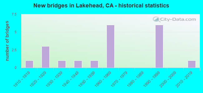
- New bridges - historical statistics
- 11910-1919
- 31920-1929
- 11930-1939
- 11940-1949
- 11950-1959
- 61960-1969
- 61990-1999
- 12010-2019
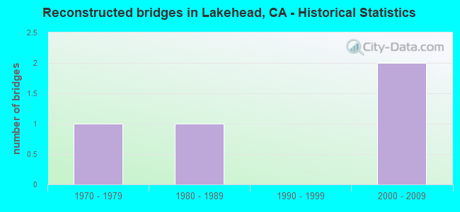
- Reconstructed bridges - Historical Statistics
- 11970-1979
- 11980-1989
- 01990-1999
- 22000-2009
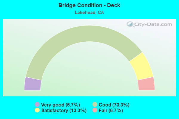
- Bridge Condition - Deck
- 6.7%Very good
- 73.3%Good
- 13.3%Satisfactory
- 6.7%Fair
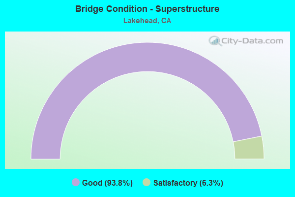
- Bridge Condition - Superstructure
- 93.8%Good
- 6.3%Satisfactory
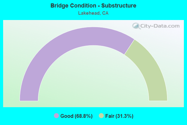
- Bridge Condition - Substructure
- 68.8%Good
- 31.3%Fair
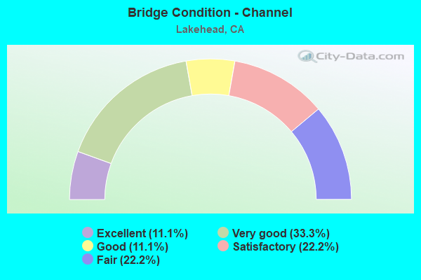
- Bridge Condition - Channel
- 11.1%Excellent
- 33.3%Very good
- 11.1%Good
- 22.2%Satisfactory
- 22.2%Fair
Find on map >> Show street view
Structure Number: 6 0027, Location: 02-SHA-005-45.54 (Lat: 40.938497, Lng: -122.422850), Route carried "on" structure: Interstate 5, Year Built: 1956, Year Reconstructed: 1989, Status: Open, Structure Length: 19.59m (64.27ft), Average Daily Traffic: 17,100 (year 2009), Truck Traffic: 32%, Average Future Daily Traffic: 30,700 (year 2040), Design Load: HS 20, Features Intersected: DOG CREEK
Minimum Vertical Clearance: 30+ m (98+ ft), Kilometerpoint: 45.540, Lanes on structure: 4, Base Highway Network: Yes (, Subroute: 1), Owner: State Highway Agency, Approaching Roadway Width: 33.4m (109.6ft), Skew: 39 degrees, Material/Design: Concrete, Design/Construction: Arch - Deck, Number Of Spans In Main Unit: 1, Number Of Approach Spans: 6, Length of Maximum Span: 95.7m (314.0ft), Curb-To-Curb Width: 33.4m (109.6ft), Out-to-Out Width: 35.1m (115.2ft)
Condition: Deck: Good, Superstructure: Good, Substructure: Fair, Channel: Excellent, Operating Rating: 49.6 metric tons, Method Used To Determine Operating Rating: Load Factor (LF), Inventory Rating: 29.8 metric tons, Method Used To Determine Inventory Rating: Load Factor (LF), Structural Evaluation: Somewhat better than minimum adequacy, Deck Geometry: Superior to present desirable criteria, Waterway Adequacy: Superior to present desirable criteria, Approach Roadway Alignment: Equal to present desirable criteria, Designated Inspection Frequency: Every 24 months, Inspection Date: March 2020, Deck Structure Type: Concrete Cast-file-Place, Wearing Surface/Protective System: Wearing Surface: Integral Concrete, Deck Protection: Epoxy Coated Reinforcing
Find on map >> Show street view
Structure Number: 6 0028, Location: 02-SHA-005-R48.83 (Lat: 40.974344, Lng: -122.432144), Route carried "on" structure: Interstate 5, Year Built: 1991, Status: Open, Structure Length: 12.80m (41.99ft), Average Daily Traffic: 17,100 (year 2009), Truck Traffic: 32%, Average Future Daily Traffic: 30,700 (year 2040), Design Load: HS 20+Mod, Features Intersected: SLATE CREEK
Minimum Vertical Clearance: 30+ m (98+ ft), Kilometerpoint: 48.830, Lanes on structure: 4, Base Highway Network: Yes (, Subroute: 1), Owner: State Highway Agency, Approaching Roadway Width: 34.1m (111.9ft), Skew: 30 degrees, Material/Design: Prestressed concrete continuous, Design/Construction: Box Beam or Girders - Multiple, Number Of Spans In Main Unit: 3, Length of Maximum Span: 51.8m (169.9ft), Curb-To-Curb Width: 34.1m (111.9ft), Out-to-Out Width: 35.8m (117.5ft)
Condition: Deck: Good, Superstructure: Good, Substructure: Fair, Channel: Very good, Operating Rating: 54.1 metric tons, Method Used To Determine Operating Rating: Assigned rating based on Load Factor Design (LFD) reported in metric tons, Inventory Rating: 32.4 metric tons, Method Used To Determine Inventory Rating: Assigned rating based on Load Factor Design (LFD) reported in metric tons, Structural Evaluation: Somewhat better than minimum adequacy, Deck Geometry: Superior to present desirable criteria, Waterway Adequacy: Equal to present desirable criteria, Approach Roadway Alignment: Equal to present desirable criteria, Designated Inspection Frequency: Every 24 months, Inspection Date: March 2020, Deck Structure Type: Concrete Cast-file-Place, Wearing Surface/Protective System: Wearing Surface: Integral Concrete, Deck Protection: Epoxy Coated Reinforcing
Find on map >> Show street view
Structure Number: 6 0158, Location: 02-SHA-005-R39.05 (Lat: 40.869144, Lng: -122.366908), Route carried "on" structure: County highway , Year Built: 1966, Status: Open, Structure Length: 5.93m (19.46ft), Average Daily Traffic: 2,900 (year 1998), Truck Traffic: 30%, Average Future Daily Traffic: 3,551 (year 2042), Design Load: HS 20, Features Intersected: INTERSTATE 5, Facility Carried by Structure: GREGORY CREEK ROAD
Minimum Vertical Clearance: 30+ m (98+ ft), Kilometerpoint: 0.000, Lanes on structure: 2, Lanes under structure: 5, Owner: State Highway Agency, Approaching Roadway Width: 7.6m (24.9ft), Skew: 1 degrees, Material/Design: Concrete continuous, Design/Construction: Box Beam or Girders - Multiple, Number Of Spans In Main Unit: 2, Length of Maximum Span: 32.3m (106.0ft), Curb or Sidewalk Widths: Left: 0.6m (2.0ft), Right: 0.6m (2.0ft), Curb-To-Curb Width: 8.5m (27.9ft), Out-to-Out Width: 10.4m (34.1ft)
Condition: Deck: Good, Superstructure: Good, Substructure: Good, Operating Rating: 45.4 metric tons, Method Used To Determine Operating Rating: Load and Resistance Factor Rating (LRFR) rating reported by rating factor(RF) method using HL-93 loadings, Inventory Rating: 35.0 metric tons, Method Used To Determine Inventory Rating: Load and Resistance Factor Rating (LRFR) rating reported by rating factor(RF) method using HL-93 loadings, Structural Evaluation: Better than present minimum criteria, Deck Geometry: Meets minimum limits, Underclear: Equal to present minimum criteria, Approach Roadway Alignment: Equal to present minimum criteria, Designated Inspection Frequency: Every 24 months, Inspection Date: Febuary 2022, Deck Structure Type: Concrete Cast-file-Place, Wearing Surface/Protective System: Wearing Surface: Integral Concrete
Find on map >> Show street view
Structure Number: 6 0159L, Location: 02-SHA-005-R37.08 (Lat: 40.850272, Lng: -122.341803), Route carried "on" structure: Interstate 5, Year Built: 1966, Year Reconstructed: 2012, Status: Open, Structure Length: 3.75m (12.30ft), Average Daily Traffic: 8,800 (year 2009), Truck Traffic: 30%, Average Future Daily Traffic: 17,129 (year 2042), Design Load: HS 20, Features Intersected: UPPER SALT CREEK ROAD
Minimum Vertical Clearance: 30+ m (98+ ft), Kilometerpoint: 37.080, Lanes on structure: 2, Lanes under structure: 2, Base Highway Network: Yes (, Subroute: 1), Owner: State Highway Agency, Approaching Roadway Width: 11.9m (39.0ft), Skew: 1 degrees, Material/Design: Concrete continuous, Design/Construction: Tee Beam, Number Of Spans In Main Unit: 3, Length of Maximum Span: 13.4m (44.0ft), Curb-To-Curb Width: 11.9m (39.0ft), Out-to-Out Width: 12.8m (42.0ft)
Condition: Deck: Good, Superstructure: Good, Substructure: Good, Operating Rating: 42.4 metric tons, Method Used To Determine Operating Rating: Load and Resistance Factor Rating (LRFR) rating reported by rating factor(RF) method using HL-93 loadings, Inventory Rating: 30.8 metric tons, Method Used To Determine Inventory Rating: Load and Resistance Factor Rating (LRFR) rating reported by rating factor(RF) method using HL-93 loadings, Structural Evaluation: Better than present minimum criteria, Deck Geometry: Equal to present minimum criteria, Underclear: Somewhat better than minimum adequacy, Approach Roadway Alignment: Equal to present minimum criteria, Designated Inspection Frequency: Every 24 months, Inspection Date: Febuary 2022, Deck Structure Type: Concrete Cast-file-Place, Wearing Surface/Protective System: Wearing Surface: Integral Concrete, Deck Protection: Epoxy Coated Reinforcing
Find on map >> Show street view
Structure Number: 6 0159R, Location: 02-SHA-005-R37.08 (Lat: 40.850325, Lng: -122.341631), Route carried "on" structure: Interstate 5, Year Built: 1966, Year Reconstructed: 2012, Status: Open, Structure Length: 3.76m (12.34ft), Average Daily Traffic: 8,800 (year 2009), Truck Traffic: 30%, Average Future Daily Traffic: 17,129 (year 2042), Design Load: HS 20, Features Intersected: UPPER SALT CREEK ROAD
Minimum Vertical Clearance: 30+ m (98+ ft), Kilometerpoint: 37.080, Lanes on structure: 2, Lanes under structure: 2, Base Highway Network: Yes (, Subroute: 1), Owner: State Highway Agency, Approaching Roadway Width: 11.9m (39.0ft), Skew: 1 degrees, Material/Design: Concrete continuous, Design/Construction: Tee Beam, Number Of Spans In Main Unit: 3, Length of Maximum Span: 13.4m (44.0ft), Curb-To-Curb Width: 11.9m (39.0ft), Out-to-Out Width: 12.8m (42.0ft)
Condition: Deck: Good, Superstructure: Good, Substructure: Good, Operating Rating: 45.4 metric tons, Method Used To Determine Operating Rating: Load and Resistance Factor Rating (LRFR) rating reported by rating factor(RF) method using HL-93 loadings, Inventory Rating: 33.0 metric tons, Method Used To Determine Inventory Rating: Load and Resistance Factor Rating (LRFR) rating reported by rating factor(RF) method using HL-93 loadings, Structural Evaluation: Better than present minimum criteria, Deck Geometry: Equal to present minimum criteria, Underclear: Meets minimum limits, Approach Roadway Alignment: Equal to present minimum criteria, Designated Inspection Frequency: Every 24 months, Inspection Date: Febuary 2022, Deck Structure Type: Concrete Cast-file-Place, Wearing Surface/Protective System: Wearing Surface: Epoxy Overlay, Deck Protection: Epoxy Coated Reinforcing
Find on map >> Show street view
Structure Number: 6 016, Location: 02-SHA-005-R36.83 (Lat: 40.847606, Lng: -122.338739), Route carried "on" structure: County highway , Year Built: 1966, Status: Open, Structure Length: 6.26m (20.54ft), Average Daily Traffic: 550 (year 1998), Truck Traffic: 35%, Average Future Daily Traffic: 700 (year 2042), Design Load: HS 20, Features Intersected: INTERSTATE 5, Facility Carried by Structure: GILMAN ROAD
Minimum Vertical Clearance: 30+ m (98+ ft), Kilometerpoint: 0.000, Lanes on structure: 2, Lanes under structure: 4, Owner: State Highway Agency, Approaching Roadway Width: 8.8m (28.9ft), Material/Design: Concrete continuous, Design/Construction: Box Beam or Girders - Multiple, Number Of Spans In Main Unit: 2, Length of Maximum Span: 31.7m (104.0ft), Curb or Sidewalk Widths: Left: 0.6m (2.0ft), Right: 0.6m (2.0ft), Curb-To-Curb Width: 8.5m (27.9ft), Out-to-Out Width: 10.4m (34.1ft)
Condition: Deck: Fair, Superstructure: Good, Substructure: Good, Operating Rating: 44.7 metric tons, Method Used To Determine Operating Rating: Load and Resistance Factor Rating (LRFR) rating reported by rating factor(RF) method using HL-93 loadings, Inventory Rating: 34.7 metric tons, Method Used To Determine Inventory Rating: Load and Resistance Factor Rating (LRFR) rating reported by rating factor(RF) method using HL-93 loadings, Structural Evaluation: Better than present minimum criteria, Deck Geometry: Somewhat better than minimum adequacy, Underclear: Somewhat better than minimum adequacy, Approach Roadway Alignment: Better than present minimum criteria, Designated Inspection Frequency: Every 24 months, Inspection Date: Febuary 2022, Deck Structure Type: Concrete Cast-file-Place, Wearing Surface/Protective System: Wearing Surface: Integral Concrete, Deck Protection: Cathodic Protection
Find on map >> Show street view
Structure Number: 6 018, Location: 02-SHA-005-R49.15 (Lat: 40.978631, Lng: -122.432628), Route carried "on" structure: County highway , Year Built: 1991, Status: Open, Structure Length: 7.56m (24.80ft), Average Daily Traffic: 20 (year 1998), Truck Traffic: 1%, Average Future Daily Traffic: 24 (year 2042), Design Load: HS 20+Mod, Features Intersected: INTERSTATE 5, Facility Carried by Structure: SLATE CREEK ROAD
Minimum Vertical Clearance: 30+ m (98+ ft), Kilometerpoint: 0.000, Lanes on structure: 2, Lanes under structure: 5, Owner: State Highway Agency, Approaching Roadway Width: 12.2m (40.0ft), Skew: 3 degrees, Material/Design: Prestressed concrete continuous, Design/Construction: Box Beam or Girders - Multiple, Number Of Spans In Main Unit: 2, Length of Maximum Span: 42.0m (137.8ft), Curb-To-Curb Width: 12.2m (40.0ft), Out-to-Out Width: 13.3m (43.6ft)
Condition: Deck: Good, Superstructure: Good, Substructure: Good, Operating Rating: 54.1 metric tons, Method Used To Determine Operating Rating: Assigned rating based on Load Factor Design (LFD) reported in metric tons, Inventory Rating: 32.4 metric tons, Method Used To Determine Inventory Rating: Assigned rating based on Load Factor Design (LFD) reported in metric tons, Structural Evaluation: Better than present minimum criteria, Deck Geometry: Superior to present desirable criteria, Underclear: Equal to present minimum criteria, Approach Roadway Alignment: Equal to present minimum criteria, Designated Inspection Frequency: Every 24 months, Inspection Date: March 2020, Deck Structure Type: Concrete Cast-file-Place, Wearing Surface/Protective System: Wearing Surface: Integral Concrete, Deck Protection: Epoxy Coated Reinforcing
Find on map >> Show street view
Structure Number: 6 0181, Location: 02-SHA-005-R45.95 (Lat: 40.941156, Lng: -122.429931), Route carried "on" structure: Interstate 5, Year Built: 1991, Status: Open, Structure Length: 3.66m (12.01ft), Average Daily Traffic: 17,100 (year 2009), Truck Traffic: 32%, Average Future Daily Traffic: 30,700 (year 2040), Design Load: HS 20+Mod, Features Intersected: VOLLMERS ROAD
Minimum Vertical Clearance: 30+ m (98+ ft), Kilometerpoint: 45.950, Lanes on structure: 5, Lanes under structure: 2, Base Highway Network: Yes (, Subroute: 1), Owner: State Highway Agency, Approaching Roadway Width: 37.4m (122.7ft), Skew: 32 degrees, Material/Design: Prestressed concrete, Design/Construction: Box Beam or Girders - Multiple, Number Of Spans In Main Unit: 1, Length of Maximum Span: 35.8m (117.5ft), Curb-To-Curb Width: 37.4m (122.7ft), Out-to-Out Width: 39.1m (128.3ft)
Condition: Deck: Good, Superstructure: Good, Substructure: Good, Operating Rating: 54.1 metric tons, Method Used To Determine Operating Rating: Assigned rating based on Load Factor Design (LFD) reported in metric tons, Inventory Rating: 32.4 metric tons, Method Used To Determine Inventory Rating: Assigned rating based on Load Factor Design (LFD) reported in metric tons, Structural Evaluation: Better than present minimum criteria, Deck Geometry: Superior to present desirable criteria, Underclear: Equal to present minimum criteria, Approach Roadway Alignment: Equal to present desirable criteria, Designated Inspection Frequency: Every 24 months, Inspection Date: March 2020, Deck Structure Type: Concrete Cast-file-Place, Wearing Surface/Protective System: Wearing Surface: Integral Concrete, Deck Protection: Epoxy Coated Reinforcing
Find on map >> Show street view
Structure Number: 6 0183, Location: 02-SHA-005-R47.35 (Lat: 40.957436, Lng: -122.435856), Route carried "on" structure: County highway , Year Built: 1991, Status: Open, Structure Length: 7.41m (24.31ft), Average Daily Traffic: 50 (year 2005), Truck Traffic: 2%, Average Future Daily Traffic: 88 (year 2042), Design Load: HS 20+Mod, Features Intersected: INTERSTATE 5, Facility Carried by Structure: MCCARDLE FLAT ROAD
Minimum Vertical Clearance: 30+ m (98+ ft), Kilometerpoint: 0.000, Lanes on structure: 2, Lanes under structure: 4, Owner: State Highway Agency, Approaching Roadway Width: 10.1m (33.1ft), Skew: 3 degrees, Material/Design: Prestressed concrete continuous, Design/Construction: Box Beam or Girders - Multiple, Number Of Spans In Main Unit: 2, Length of Maximum Span: 41.7m (136.8ft), Curb-To-Curb Width: 9.8m (32.2ft), Out-to-Out Width: 10.8m (35.4ft)
Condition: Deck: Good, Superstructure: Good, Substructure: Good, Operating Rating: 54.1 metric tons, Method Used To Determine Operating Rating: Assigned rating based on Load Factor Design (LFD) reported in metric tons, Inventory Rating: 32.4 metric tons, Method Used To Determine Inventory Rating: Assigned rating based on Load Factor Design (LFD) reported in metric tons, Structural Evaluation: Better than present minimum criteria, Deck Geometry: Equal to present desirable criteria, Underclear: Equal to present minimum criteria, Approach Roadway Alignment: Somewhat better than minimum adequacy, Designated Inspection Frequency: Every 24 months, Inspection Date: March 2020, Deck Structure Type: Concrete Cast-file-Place, Wearing Surface/Protective System: Wearing Surface: Monolithic Concrete, Deck Protection: Epoxy Coated Reinforcing
Find on map >> Show street view
Structure Number: 6 021, Location: 02-SHA-005-R39.98 (Lat: 40.879250, Lng: -122.378236), Route carried "on" structure: Interstate 5, Year Built: 2016, Status: Open, Structure Length: 59.20m (194.23ft), Average Daily Traffic: 17,600 (year 2009), Truck Traffic: 30%, Average Future Daily Traffic: 32,700 (year 2037), Design Load: HL 93, Features Intersected: SACRAMENTO RIVER
Minimum Vertical Clearance: 30+ m (98+ ft), Kilometerpoint: 39.980, Lanes on structure: 5, Base Highway Network: Yes (, Subroute: 1), Owner: State Highway Agency, Approaching Roadway Width: 30.0m (98.4ft), Skew: 30 degrees, Material/Design: Prestressed concrete continuous, Design/Construction: Segmental Box Girder, Number Of Spans In Main Unit: 5, Length of Maximum Span: 180.0m (590.6ft), Curb-To-Curb Width: 30.0m (98.4ft), Out-to-Out Width: 31.8m (104.3ft)
Condition: Deck: Good, Superstructure: Good, Substructure: Good, Channel: Very good, Operating Rating: 42.1 metric tons, Method Used To Determine Operating Rating: Assigned ratings based on Load and Resistance Factor Design (LRFD) reported by rating factor (RF) using HL93 loadings, Inventory Rating: 32.4 metric tons, Method Used To Determine Inventory Rating: Assigned ratings based on Load and Resistance Factor Design (LRFD) reported by rating factor (RF) using HL93 loadings, Structural Evaluation: Better than present minimum criteria, Deck Geometry: Superior to present desirable criteria, Waterway Adequacy: Equal to present desirable criteria, Approach Roadway Alignment: Equal to present desirable criteria, Designated Inspection Frequency: Every 24 months, Underwater Inspection Frequency: Every 60 months, Inspection Date: May 2020, Underwater Inspection Date: October 2020, Deck Structure Type: Concrete Cast-file-Place, Wearing Surface/Protective System: Wearing Surface: Integral Concrete, Deck Protection: Epoxy Coated Reinforcing
Find on map >> Show street view
Structure Number: 6C0054, Location: 1.8 MI SW ANTLR UC ON I-5 (Lat: 40.869097, Lng: -122.392050), Route carried "on" structure: County highway , Year Built: 1926, Year Reconstructed: 1981, Status: Open, Structure Length: 12.19m (39.99ft), Average Daily Traffic: 1,383 (year 2013), Truck Traffic: 5%, Average Future Daily Traffic: 3,000 (year 2038), Design Load: H 15, Features Intersected: CHARLIE CREEK, Facility Carried by Structure: LAKE SHORE DRIVE
Minimum Vertical Clearance: 30+ m (98+ ft), Kilometerpoint: 0.000, Lanes on structure: 2, Owner: County Highway Agency, Approaching Roadway Width: 7.6m (24.9ft), Material/Design: Concrete, Design/Construction: Arch - Deck, Number Of Spans In Main Unit: 1, Number Of Approach Spans: 8, Length of Maximum Span: 46.9m (153.9ft), Curb-To-Curb Width: 7.3m (24.0ft), Out-to-Out Width: 7.7m (25.3ft)
Condition: Deck: Good, Superstructure: Good, Substructure: Fair, Channel: Satisfactory, Operating Rating: 26.6 metric tons, Method Used To Determine Operating Rating: Allowable Stress (AS), Inventory Rating: 18.1 metric tons, Method Used To Determine Inventory Rating: Allowable Stress (AS), Structural Evaluation: Somewhat better than minimum adequacy, Deck Geometry: Meets minimum limits, Waterway Adequacy: Superior to present desirable criteria, Approach Roadway Alignment: Equal to present minimum criteria, Designated Inspection Frequency: Every 24 months, Inspection Date: July 2021, Deck Structure Type: Wood or Timber, Wearing Surface/Protective System: Wearing Surface: Bituminous
Find on map >> Show street view
Structure Number: 6C0062, Location: 0.1 MI E SLATE CREEK RD (Lat: 40.974828, Lng: -122.433306), Route carried "on" structure: County highway , Year Built: 1927, Status: Open, Structure Length: 5.58m (18.31ft), Average Daily Traffic: 52 (year 2013), Truck Traffic: 5%, Average Future Daily Traffic: 157 (year 2038), Features Intersected: SLATE CREEK, Facility Carried by Structure: MOINE ROAD
Minimum Vertical Clearance: 30+ m (98+ ft), Kilometerpoint: 0.000, Lanes on structure: 2, Owner: County Highway Agency, Approaching Roadway Width: 7.0m (23.0ft), Skew: 4 degrees, Material/Design: Concrete, Design/Construction: Tee Beam, Number Of Spans In Main Unit: 6, Length of Maximum Span: 17.1m (56.1ft), Curb or Sidewalk Widths: Left: 0.2m (0.7ft), Right: 0.2m (0.7ft), Curb-To-Curb Width: 7.3m (24.0ft), Out-to-Out Width: 8.2m (26.9ft)
Condition: Deck: Good, Superstructure: Good, Substructure: Fair, Channel: Satisfactory, Operating Rating: 25.6 metric tons, Method Used To Determine Operating Rating: Load and Resistance Factor Rating (LRFR) rating reported by rating factor(RF) method using HL-93 loadings, Inventory Rating: 17.8 metric tons, Method Used To Determine Inventory Rating: Load and Resistance Factor Rating (LRFR) rating reported by rating factor(RF) method using HL-93 loadings, Structural Evaluation: Somewhat better than minimum adequacy, Deck Geometry: Equal to present minimum criteria, Waterway Adequacy: Superior to present desirable criteria, Approach Roadway Alignment: Somewhat better than minimum adequacy, Designated Inspection Frequency: Every 24 months, Inspection Date: July 2021, Deck Structure Type: Concrete Cast-file-Place, Wearing Surface/Protective System: Wearing Surface: Bituminous
Find on map >> Show street view
Structure Number: 6C0229, Location: 0.4 MI W OF I-5 (Lat: 40.973594, Lng: -122.440119), Route carried "on" structure: County highway , Year Built: 1920, Status: Open, Structure Length: 1.86m (6.10ft), Average Daily Traffic: 82 (year 2001), Truck Traffic: 15%, Average Future Daily Traffic: 320 (year 2038), Features Intersected: SLATE CREEK, Facility Carried by Structure: SLATE CREEK ROAD
Minimum Vertical Clearance: 30+ m (98+ ft), Kilometerpoint: 0.000, Lanes on structure: 2, Owner: County Highway Agency, Approaching Roadway Width: 6.9m (22.6ft), Material/Design: Concrete, Design/Construction: Arch - Deck, Number Of Spans In Main Unit: 1, Length of Maximum Span: 18.0m (59.1ft), Curb-To-Curb Width: 6.9m (22.6ft), Out-to-Out Width: 7.5m (24.6ft)
Condition: Superstructure: Good, Substructure: Good, Channel: Fair, Operating Rating: 24.6 metric tons, Method Used To Determine Operating Rating: Field evaluation and documented engineering judgment, Inventory Rating: 14.9 metric tons, Method Used To Determine Inventory Rating: Field evaluation and documented engineering judgment, Structural Evaluation: Meets minimum limits, Deck Geometry: Somewhat better than minimum adequacy, Waterway Adequacy: Superior to present desirable criteria, Approach Roadway Alignment: Meets minimum limits, Designated Inspection Frequency: Every 24 months, Inspection Date: July 2021
Find on map >> Show street view
Structure Number: 51458000001058, Location: NO DATA ENTERED (Lat: 40.949247, Lng: -122.342569), Route carried "on" structure: Federal lands road 34N17, Year Built: 1936, Status: Posted for load, Structure Length: 0.96m (3.15ft), Average Daily Traffic: 50 (year 0000), Average Future Daily Traffic: 75 (year 2042), Design Load: H 20, Features Intersected: EYE CREEK, Facility Carried by Structure: FENDER FERRY
Minimum Vertical Clearance: 30+ m (98+ ft), Kilometerpoint: 55.936, Lanes on structure: 1, Owner: U.S. Forest Service, Approaching Roadway Width: 4.3m (14.1ft), Material/Design: Steel, Design/Construction: Stringer/Multi-beam, Number Of Spans In Main Unit: 1, Length of Maximum Span: 8.9m (29.2ft), Curb or Sidewalk Widths: Left: 0.2m (0.7ft), Right: 0.2m (0.7ft), Curb-To-Curb Width: 4.0m (13.1ft), Out-to-Out Width: 4.1m (13.5ft)
Condition: Deck: Very good, Superstructure: Good, Substructure: Good, Channel: Good, Deck Geometry: Somewhat better than minimum adequacy, Waterway Adequacy: Better than present minimum criteria, Approach Roadway Alignment: Equal to present desirable criteria, Bridge Posting: Required (Relationship of Operating Rating to Maximum Legal Load: > 39.9% below), Designated Inspection Frequency: Every 24 months, Inspection Date: May 2021, Deck Structure Type: Wood or Timber, Wearing Surface/Protective System: Wearing Surface: Wood or Timber
Find on map >> Show street view
Structure Number: 51458000001059, Location: NO DATA ENTERED (Lat: 40.938064, Lng: -122.421217), Route carried "on" structure: Federal lands road 34N17, Year Built: 1944, Status: Open, Structure Length: 1.83m (6.00ft), Average Daily Traffic: 50 (year 0000), Average Future Daily Traffic: 75 (year 2042), Design Load: H 20, Features Intersected: DOG CREEK, Facility Carried by Structure: FENDER FERRY RD
Minimum Vertical Clearance: 30+ m (98+ ft), Kilometerpoint: 93.300, Lanes on structure: 1, Owner: U.S. Forest Service, Approaching Roadway Width: 3.7m (12.1ft), Skew: 4 degrees, Material/Design: Steel, Design/Construction: Stringer/Multi-beam, Number Of Spans In Main Unit: 1, Length of Maximum Span: 0.0m, Curb-To-Curb Width: 3.7m (12.1ft), Out-to-Out Width: 3.7m (12.1ft)
Condition: Deck: Satisfactory, Superstructure: Good, Substructure: Good, Channel: Very good, Operating Rating: 33.7 metric tons, Method Used To Determine Operating Rating: Load and Resistance Factor Rating (LRFR) rating reported by rating factor(RF) method using HL-93 loadings, Inventory Rating: 25.9 metric tons, Method Used To Determine Inventory Rating: Load and Resistance Factor Rating (LRFR) rating reported by rating factor(RF) method using HL-93 loadings, Structural Evaluation: Equal to present minimum criteria, Deck Geometry: Meets minimum limits, Waterway Adequacy: Better than present minimum criteria, Approach Roadway Alignment: Equal to present minimum criteria, Designated Inspection Frequency: Every 24 months, Inspection Date: March 2021, Deck Structure Type: Concrete Cast-file-Place, Wearing Surface/Protective System: Wearing Surface: Monolithic Concrete
Find on map >> Show street view
Structure Number: 51458000001108, Location: NO DATA ENTERED (Lat: 40.939444, Lng: -122.424167), Route carried "on" structure: Federal lands road 34N17, Year Built: 1917, Status: Posted for load, Structure Length: 3.67m (12.04ft), Average Daily Traffic: 50 (year 0000), Average Future Daily Traffic: 75 (year 2042), Features Intersected: DOG CREEK, Facility Carried by Structure: FENDER FERRY
Minimum Vertical Clearance: 30+ m (98+ ft), Kilometerpoint: 93.520, Lanes on structure: 1, Owner: U.S. Forest Service, Approaching Roadway Width: 6.7m (22.0ft), Material/Design: Concrete, Design/Construction: Tee Beam, Number Of Spans In Main Unit: 3, Length of Maximum Span: 12.2m (40.0ft), Curb-To-Curb Width: 6.4m (21.0ft), Out-to-Out Width: 7.1m (23.3ft)
Condition: Deck: Satisfactory, Superstructure: Satisfactory, Substructure: Fair, Channel: Fair, Operating Rating: 14.6 metric tons, Method Used To Determine Operating Rating: Load and Resistance Factor Rating (LRFR) rating reported by rating factor(RF) method using HL-93 loadings, Inventory Rating: 11.3 metric tons, Method Used To Determine Inventory Rating: Load and Resistance Factor Rating (LRFR) rating reported by rating factor(RF) method using HL-93 loadings, Structural Evaluation: Meets minimum limits, Deck Geometry: Somewhat better than minimum adequacy, Waterway Adequacy: Better than present minimum criteria, Approach Roadway Alignment: Equal to present desirable criteria, Bridge Posting: Required (Relationship of Operating Rating to Maximum Legal Load: 30.0 - 39.9% below), Designated Inspection Frequency: Every 24 months, Inspection Date: March 2021, Deck Structure Type: Concrete Cast-file-Place
Find on map >> Show street view
Structure Number: 6 0158, Location: 02-SHA-005-R39.05 (Lat: 40.869144, Lng: -122.366908), Route carried "under" structure: Interstate 5, Year Built: 1966, Structure Length: 0. m, Average Daily Traffic: 17,600 (year 2009), Truck Traffic: 30%, Features Intersected: INTERSTATE 5, Facility Carried by Structure: GREGORY CREEK ROAD
Minimum Vertical Clearance: 5.33m (17.49ft), Kilometerpoint: 39.050, Lanes on structure: 2, Lanes under structure: 5, Material/Design: Concrete continuous, Design/Construction: Box Beam or Girders - Multiple, Length of Maximum Span: 32.3m (106.0ft)
Find on map >> Show street view
Structure Number: 6 016, Location: 02-SHA-005-R36.83 (Lat: 40.847606, Lng: -122.338739), Route carried "under" structure: Interstate 5, Year Built: 1966, Structure Length: 0. m, Average Daily Traffic: 17,600 (year 2009), Truck Traffic: 30%, Features Intersected: INTERSTATE 5, Facility Carried by Structure: GILMAN ROAD
Minimum Vertical Clearance: 4.95m (16.24ft), Kilometerpoint: 36.830, Lanes on structure: 2, Lanes under structure: 4, Material/Design: Concrete continuous, Design/Construction: Box Beam or Girders - Multiple, Length of Maximum Span: 31.7m (104.0ft)
Find on map >> Show street view
Structure Number: 6 018, Location: 02-SHA-005-R49.15 (Lat: 40.978631, Lng: -122.432628), Route carried "under" structure: Interstate 5, Year Built: 1991, Structure Length: 0. m, Average Daily Traffic: 17,100 (year 2009), Truck Traffic: 32%, Features Intersected: INTERSTATE 5, Facility Carried by Structure: SLATE CREEK ROAD
Minimum Vertical Clearance: 5.08m (16.67ft), Kilometerpoint: 49.150, Lanes on structure: 2, Lanes under structure: 5, Material/Design: Prestressed concrete continuous, Design/Construction: Box Beam or Girders - Multiple, Length of Maximum Span: 42.0m (137.8ft)
Find on map >> Show street view
Structure Number: 6 0183, Location: 02-SHA-005-R47.35 (Lat: 40.957436, Lng: -122.435856), Route carried "under" structure: Interstate 5, Year Built: 1991, Structure Length: 0. m, Average Daily Traffic: 17,100 (year 2009), Truck Traffic: 32%, Features Intersected: INTERSTATE 5, Facility Carried by Structure: MCCARDLE FLAT ROAD
Minimum Vertical Clearance: 5.31m (17.42ft), Kilometerpoint: 47.350, Lanes on structure: 2, Lanes under structure: 4, Material/Design: Prestressed concrete continuous, Design/Construction: Box Beam or Girders - Multiple, Length of Maximum Span: 41.7m (136.8ft)