Bridge Statistics for Lanham, Maryland (MD)
Condition, Traffic, Stress, Structural Evaluation, Project Costs
- National Bridge Inventory (NBI) Statistics
- 13Number of bridges
- 276ft / 84.1mTotal length
- $9,532,000Total costs
- 1,376,004Total average daily traffic
- 87,495Total average daily truck traffic
- National Bridge Inventory (NBI) Registered Bridges for Lanham
- No street view available for this location
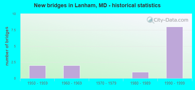
- New bridges - historical statistics
- 21950-1959
- 21960-1969
- 11980-1989
- 81990-1999
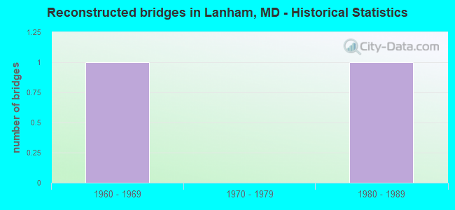
- Reconstructed bridges - Historical Statistics
- 11960-1969
- 01970-1979
- 11980-1989
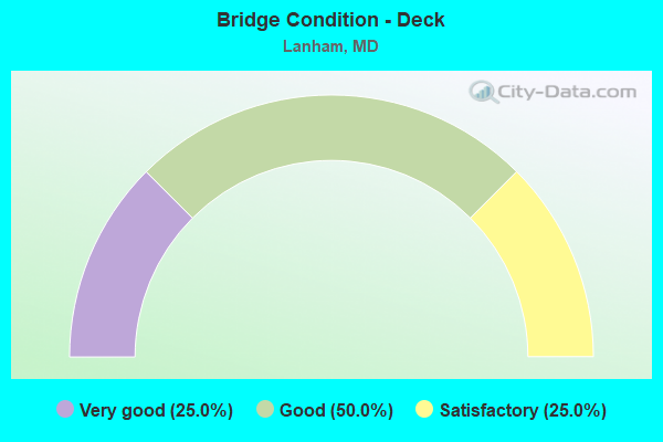
- Bridge Condition - Deck
- 25.0%Very good
- 50.0%Good
- 25.0%Satisfactory
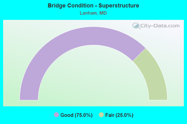
- Bridge Condition - Superstructure
- 75.0%Good
- 25.0%Fair
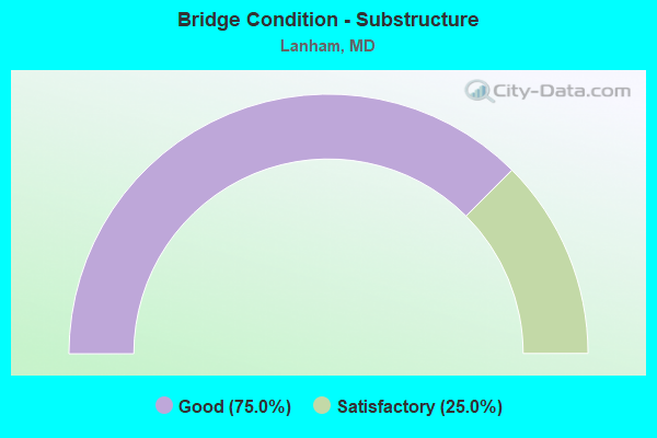
- Bridge Condition - Substructure
- 75.0%Good
- 25.0%Satisfactory
Find on map >> Show street view
Structure Number: 100000160144015, Location: 1.05 MILES N OF IS 595 (Lat: 38.959297, Lng: -76.865903), Route carried "on" structure: Interstate 95, Year Built: 1963, Year Reconstructed: 1971, Status: Open, Structure Length: 5.82m (19.09ft), Average Daily Traffic: 204,147 (year 2009), Truck Traffic: 8%, Average Future Daily Traffic: 113,589 (year 2026), Design Load: HS 20, Features Intersected: MD 450
Minimum Vertical Clearance: 30+ m (98+ ft), Kilometerpoint: 31.495, Lanes on structure: 4, Lanes under structure: 4, Base Highway Network: Yes, Owner: State Highway Agency, Approaching Roadway Width: 21.3m (69.9ft), Skew: 1 degrees, Material/Design: Steel, Design/Construction: Stringer/Multi-beam, Number Of Spans In Main Unit: 4, Length of Maximum Span: 16.5m (54.1ft), Curb-To-Curb Width: 20.1m (65.9ft), Out-to-Out Width: 21.7m (71.2ft)
Condition: Deck: Satisfactory, Superstructure: Fair, Substructure: Satisfactory, Operating Rating: 58.0 metric tons, Method Used To Determine Operating Rating: Load Factor (LF), Inventory Rating: 34.9 metric tons, Method Used To Determine Inventory Rating: Load Factor (LF), Structural Evaluation: Somewhat better than minimum adequacy, Deck Geometry: Equal to present minimum criteria, Underclear: Equal to present minimum criteria, Approach Roadway Alignment: Equal to present desirable criteria, Length Of Structure Improvement: 5.82m (19.09ft), Designated Inspection Frequency: Every 24 months, Inspection Date: September 2021, Bridge Improvement Cost: $1,632,000, Roadway Improvement Cost: $163,000, Total Project Cost: $1,795,000, Deck Structure Type: Concrete Cast-file-Place, Wearing Surface/Protective System: Wearing Surface: Bituminous
Find on map >> Show street view
Structure Number: 10000016014601, Location: 0.29 MILE EAST OF US 50 (Lat: 38.945242, Lng: -76.858658), Route carried "on" structure: Interstate 595, Year Built: 1958, Year Reconstructed: 1988, Status: Open, Structure Length: 7.96m (26.12ft), Average Daily Traffic: 153,970 (year 2009), Truck Traffic: 8%, Average Future Daily Traffic: 240,810 (year 2029), Design Load: HS 20, Features Intersected: IS 95
Minimum Vertical Clearance: 30+ m (98+ ft), Kilometerpoint: 0.467, Lanes on structure: 8, Lanes under structure: 8, Base Highway Network: Yes, Owner: State Highway Agency, Approaching Roadway Width: 45.1m (148.0ft), Skew: 31 degrees, Material/Design: Steel, Design/Construction: Stringer/Multi-beam, Number Of Spans In Main Unit: 4, Length of Maximum Span: 26.5m (86.9ft), Curb-To-Curb Width: 44.3m (145.3ft), Out-to-Out Width: 46.4m (152.2ft)
Condition: Deck: Very good, Superstructure: Good, Substructure: Good, Operating Rating: 77.5 metric tons, Method Used To Determine Operating Rating: Load Factor (LF), Inventory Rating: 46.7 metric tons, Method Used To Determine Inventory Rating: Load Factor (LF), Structural Evaluation: Better than present minimum criteria, Deck Geometry: Superior to present desirable criteria, Underclear: Somewhat better than minimum adequacy, Approach Roadway Alignment: Equal to present desirable criteria, Designated Inspection Frequency: Every 24 months, Inspection Date: December 2020, Deck Structure Type: Concrete Cast-file-Place, Wearing Surface/Protective System: Wearing Surface: Monolithic Concrete
Find on map >> Show street view
Structure Number: 10000016022301, Location: 0.1 MI W OF IS 595, US 50 (Lat: 38.947997, Lng: -76.860217), Route carried "on" structure: Ramp Interstate 595, Year Built: 1992, Status: Open, Structure Length: 67.42m (221.19ft), Average Daily Traffic: 22,561 (year 2019), Truck Traffic: 8%, Average Future Daily Traffic: 27,530 (year 2039), Design Load: HS 20, Features Intersected: IS 95, IS 595, RAMP D&E
Minimum Vertical Clearance: 30+ m (98+ ft), Kilometerpoint: 0.354, Lanes on structure: 2, Lanes under structure: 19, Base Highway Network: Yes, Owner: State Highway Agency, Approaching Roadway Width: 16.2m (53.1ft), Skew: 1 degrees, Material/Design: Steel continuous, Design/Construction: Stringer/Multi-beam, Number Of Spans In Main Unit: 17, Length of Maximum Span: 57.0m (187.0ft), Curb-To-Curb Width: 13.4m (44.0ft), Out-to-Out Width: 16.2m (53.1ft)
Condition: Deck: Good, Superstructure: Good, Substructure: Good, Operating Rating: 57.6 metric tons, Method Used To Determine Operating Rating: Load Factor (LF), Inventory Rating: 34.5 metric tons, Method Used To Determine Inventory Rating: Load Factor (LF), Structural Evaluation: Better than present minimum criteria, Deck Geometry: Superior to present desirable criteria, Underclear: High priority of corrective action, Approach Roadway Alignment: Equal to present desirable criteria, Length Of Structure Improvement: 67.42m (221.19ft), Designated Inspection Frequency: Every 24 months, Inspection Date: October 2020, Bridge Improvement Cost: $7,034,000, Roadway Improvement Cost: $703,000, Total Project Cost: $7,737,000, Deck Structure Type: Concrete Cast-file-Place, Wearing Surface/Protective System: Wearing Surface: Integral Concrete, Deck Protection: Epoxy Coated Reinforcing
Find on map >> Show street view
Structure Number: 10000016022401, Location: IS 595,IS 95-495 INT (Lat: 38.951647, Lng: -76.862797), Route carried "on" structure: Ramp Interstate 595, Year Built: 1988, Status: Open, Structure Length: 2.90m (9.51ft), Average Daily Traffic: 22,154 (year 2006), Truck Traffic: 8%, Average Future Daily Traffic: 25,544 (year 2026), Design Load: HS 20+Mod, Features Intersected: COBB ROAD
Minimum Vertical Clearance: 30+ m (98+ ft), Kilometerpoint: 0.467, Lanes on structure: 1, Lanes under structure: 2, Base Highway Network: Yes, Owner: State Highway Agency, Approaching Roadway Width: 9.1m (29.9ft), Skew: 6 degrees, Material/Design: Steel, Design/Construction: Stringer/Multi-beam, Number Of Spans In Main Unit: 1, Length of Maximum Span: 27.4m (89.9ft), Curb-To-Curb Width: 9.1m (29.9ft), Out-to-Out Width: 10.4m (34.1ft)
Condition: Deck: Good, Superstructure: Good, Substructure: Good, Inventory Rating: 59.9 metric tons, Method Used To Determine Inventory Rating: Load Factor (LF), Structural Evaluation: Better than present minimum criteria, Deck Geometry: Superior to present desirable criteria, Underclear: Meets minimum limits, Approach Roadway Alignment: Equal to present desirable criteria, Designated Inspection Frequency: Every 24 months, Inspection Date: April 2021, Deck Structure Type: Concrete Cast-file-Place, Wearing Surface/Protective System: Wearing Surface: Monolithic Concrete, Deck Protection: Epoxy Coated Reinforcing
Find on map >> Show street view
Structure Number: 100000160144015, Location: 0.3 MILE WEST OF MD 564 (Lat: 38.959297, Lng: -76.865903), Route carried "under" structure: State highway 450, Year Built: 1963, Structure Length: 0. m, Average Daily Traffic: 51,370 (year 2009), Features Intersected: MD 450, Facility Carried by Structure: IS 95/495
Minimum Vertical Clearance: 4.88m (16.01ft), Kilometerpoint: 7.482, Lanes on structure: 4, Lanes under structure: 4, Material/Design: Steel, Design/Construction: Stringer/Multi-beam, Length of Maximum Span: 16.5m (54.1ft)
Find on map >> Show street view
Structure Number: 10000016014601, Location: 0.43 MILE NORTH OF MD 704 (Lat: 38.945342, Lng: -76.858714), Route carried "under" structure: Interstate 95, Year Built: 1958, Structure Length: 0. m, Average Daily Traffic: 230,880 (year 2009), Features Intersected: IS 95
Minimum Vertical Clearance: 4.88m (16.01ft), Kilometerpoint: 29.831, Lanes on structure: 2, Lanes under structure: 8, Material/Design: Steel, Design/Construction: Stringer/Multi-beam, Length of Maximum Span: 26.5m (86.9ft)
Find on map >> Show street view
Structure Number: 10000016022301, Location: 0.15 MILE NORTH OF IS 595 (Lat: 38.947997, Lng: -76.860217), Route carried "under" structure: Ramp Interstate 95, Year Built: 1992, Structure Length: 0. m, Average Daily Traffic: 22,154 (year 2006), Truck Traffic: 8%, Features Intersected: IS 95 RAMP D(7)
Minimum Vertical Clearance: 9.75m (31.99ft), Kilometerpoint: 30.072, Lanes on structure: 2, Lanes under structure: 1, Material/Design: Steel continuous, Design/Construction: Stringer/Multi-beam, Length of Maximum Span: 57.0m (187.0ft)
Find on map >> Show street view
Structure Number: 10000016022301, Location: 0.07 MILE WEAS OF IS 95 (Lat: 38.947997, Lng: -76.860217), Route carried "under" structure: Interstate 595, Year Built: 1992, Structure Length: 0. m, Average Daily Traffic: 91,392 (year 2009), Truck Traffic: 8%, Features Intersected: IS 595
Minimum Vertical Clearance: 5.18m (16.99ft), Kilometerpoint: 0.354, Lanes on structure: 2, Lanes under structure: 9, Material/Design: Steel continuous, Design/Construction: Stringer/Multi-beam, Length of Maximum Span: 57.0m (187.0ft)
Find on map >> Show street view
Structure Number: 10000016022301, Location: 0.05 MILE SOUTH OF IS 595 (Lat: 38.947997, Lng: -76.860217), Route carried "under" structure: Interstate 95, Year Built: 1992, Structure Length: 0. m, Average Daily Traffic: 212,990 (year 2009), Truck Traffic: 8%, Features Intersected: IS 95
Minimum Vertical Clearance: 6.10m (20.01ft), Kilometerpoint: 29.750, Lanes on structure: 2, Lanes under structure: 8, Material/Design: Steel continuous, Design/Construction: Stringer/Multi-beam, Length of Maximum Span: 57.0m (187.0ft)
Find on map >> Show street view
Structure Number: 10000016022301, Location: 0.09 MILE NORTH OF IS 595 (Lat: 38.947997, Lng: -76.860217), Route carried "under" structure: Ramp Interstate 595, Year Built: 1992, Structure Length: 0. m, Average Daily Traffic: 10,526 (year 2006), Truck Traffic: 8%, Features Intersected: IS 95 RAMP E(8)
Minimum Vertical Clearance: 5.18m (16.99ft), Kilometerpoint: 0.338, Lanes on structure: 2, Lanes under structure: 1, Material/Design: Steel continuous, Design/Construction: Stringer/Multi-beam, Length of Maximum Span: 57.0m (187.0ft)
Find on map >> Show street view
Structure Number: 10000016022701, Location: 0.12 MILE NORTH OF IS 595 (Lat: 38.947997, Lng: -76.860217), Route carried "under" structure: Interstate 95, Year Built: 1990, Structure Length: 0. m, Average Daily Traffic: 230,880 (year 2009), Truck Traffic: 8%, Features Intersected: IS 95
Minimum Vertical Clearance: 5.18m (16.99ft), Kilometerpoint: 30.024, Lanes on structure: 1, Lanes under structure: 8, Material/Design: Steel continuous, Design/Construction: Stringer/Multi-beam, Length of Maximum Span: 47.9m (157.2ft)
Find on map >> Show street view
Structure Number: 10000016022701, Location: 0.12 MILE WEST OF IS 95 (Lat: 38.947997, Lng: -76.860217), Route carried "under" structure: Interstate 595, Year Built: 1990, Structure Length: 0. m, Average Daily Traffic: 111,332 (year 2006), Truck Traffic: 8%, Features Intersected: IS 595
Minimum Vertical Clearance: 5.18m (16.99ft), Kilometerpoint: 0.274, Lanes on structure: 1, Lanes under structure: 8, Material/Design: Steel continuous, Design/Construction: Stringer/Multi-beam, Length of Maximum Span: 47.9m (157.2ft)
Find on map >> Show street view
Structure Number: 10000016022701, Location: 0.05 MILE SOUTH OF IS 595 (Lat: 38.947997, Lng: -76.860217), Route carried "under" structure: Ramp Interstate 595, Year Built: 1990, Structure Length: 0. m, Average Daily Traffic: 11,648 (year 2006), Truck Traffic: 8%, Features Intersected: IS 595 RAMPS B(3) & G(6)
Minimum Vertical Clearance: 6.71m (22.01ft), Kilometerpoint: 0.274, Lanes on structure: 1, Lanes under structure: 2, Material/Design: Steel continuous, Design/Construction: Stringer/Multi-beam, Length of Maximum Span: 47.9m (157.2ft)