Bridge Statistics for Larkspur, California (CA)
Condition, Traffic, Stress, Structural Evaluation, Project Costs
- National Bridge Inventory (NBI) Statistics
- 12Number of bridges
- 515ft / 157mTotal length
- $9,187,000Total costs
- 692,641Total average daily traffic
- 20,992Total average daily truck traffic
- National Bridge Inventory (NBI) Registered Bridges for Larkspur
- No street view available for this location
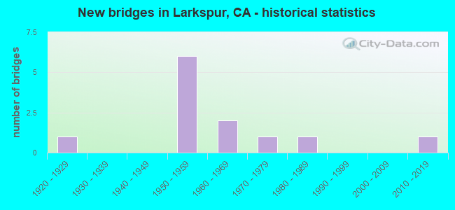
- New bridges - historical statistics
- 11920-1929
- 61950-1959
- 21960-1969
- 11970-1979
- 11980-1989
- 12010-2019
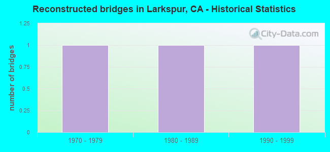
- Reconstructed bridges - Historical Statistics
- 11970-1979
- 11980-1989
- 11990-1999
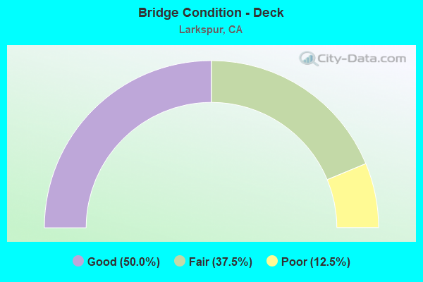
- Bridge Condition - Deck
- 50.0%Good
- 37.5%Fair
- 12.5%Poor
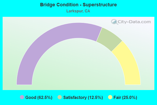
- Bridge Condition - Superstructure
- 62.5%Good
- 12.5%Satisfactory
- 25.0%Fair
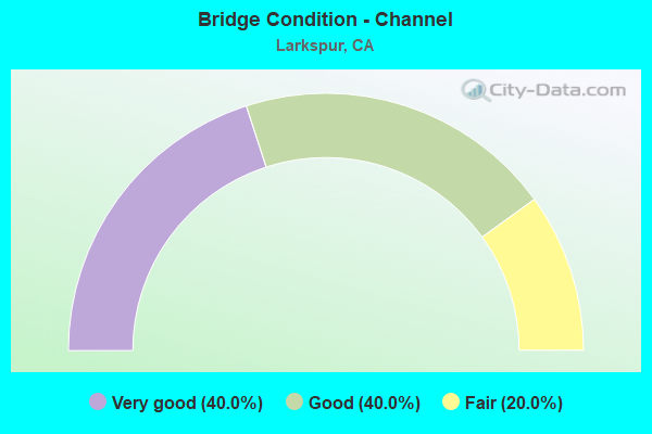
- Bridge Condition - Channel
- 40.0%Very good
- 40.0%Good
- 20.0%Fair
Find on map >> Show street view
Structure Number: 27 0002, Location: 04-MRN-101-13.25-SRF (Lat: 38.001394, Lng: -122.537203), Route carried "on" structure: US 101, Year Built: 1957, Year Reconstructed: 1987, Status: Open, Structure Length: 4.16m (13.65ft), Average Daily Traffic: 167,000 (year 2009), Truck Traffic: 4%, Average Future Daily Traffic: 243,761 (year 2038), Design Load: HS 20, Features Intersected: NWP RR / SMART
Minimum Vertical Clearance: 30+ m (98+ ft), Kilometerpoint: 13.250, Lanes on structure: 9, Base Highway Network: Yes (Inventory Route: 1, Subroute: 1), Owner: State Highway Agency, Approaching Roadway Width: 40.8m (133.9ft), Skew: 31 degrees, Material/Design: Prestressed concrete, Design/Construction: Slab, Number Of Spans In Main Unit: 3, Length of Maximum Span: 13.7m (44.9ft), Curb-To-Curb Width: 41.8m (137.1ft), Out-to-Out Width: 43.7m (143.4ft)
Condition: Deck: Good, Superstructure: Good, Substructure: Good, Operating Rating: 52.8 metric tons, Method Used To Determine Operating Rating: Load Factor (LF), Inventory Rating: 32.4 metric tons, Method Used To Determine Inventory Rating: Load Factor (LF), Structural Evaluation: Better than present minimum criteria, Deck Geometry: Superior to present desirable criteria, Underclear: Somewhat better than minimum adequacy, Approach Roadway Alignment: Equal to present desirable criteria, Designated Inspection Frequency: Every 48 months, Inspection Date: March 2021, Deck Structure Type: Concrete Cast-file-Place, Wearing Surface/Protective System: Wearing Surface: Bituminous
Find on map >> Show street view
Structure Number: 27 0008, Location: 04-MRN-101-8.47-LKSP (Lat: 37.941881, Lng: -122.515456), Route carried "on" structure: US 101, Year Built: 1957, Year Reconstructed: 2004, Status: Open, Structure Length: 38.56m (126.51ft), Average Daily Traffic: 172,000 (year 2009), Truck Traffic: 2%, Average Future Daily Traffic: 226,699 (year 2040), Design Load: HS 20, Features Intersected: CORTE MADERA CR & SFD BL
Minimum Vertical Clearance: 30+ m (98+ ft), Kilometerpoint: 8.470, Lanes on structure: 8, Lanes under structure: 7, Base Highway Network: Yes (Inventory Route: 1, Subroute: 1), Owner: State Highway Agency, Approaching Roadway Width: 32.9m (107.9ft), Skew: 39 degrees, Navigation Control: Yes ( Vertical Clearance: 6.4m (21.0ft), Horizontal Clearance: 12.2m (40.0ft)), Material/Design: Concrete continuous, Design/Construction: Box Beam or Girders - Multiple, Number Of Spans In Main Unit: 12, Number Of Approach Spans: 1, Length of Maximum Span: 24.4m (80.1ft), Curb or Sidewalk Widths: Left: 0.0m, Right: 0.6m (2.0ft), Curb-To-Curb Width: 32.0m (105.0ft), Out-to-Out Width: 34.0m (111.5ft)
Condition: Deck: Fair, Superstructure: Good, Substructure: Good, Channel: Very good, Operating Rating: 57.1 metric tons, Method Used To Determine Operating Rating: Load Factor (LF), Inventory Rating: 33.5 metric tons, Method Used To Determine Inventory Rating: Load Factor (LF), Structural Evaluation: Better than present minimum criteria, Deck Geometry: Meets minimum limits, Underclear: Meets minimum limits, Waterway Adequacy: Equal to present desirable criteria, Approach Roadway Alignment: Better than present minimum criteria, Designated Inspection Frequency: Every 24 months, Underwater Inspection Frequency: Every 60 months, Inspection Date: May 2020, Underwater Inspection Date: May 2018, Deck Structure Type: Concrete Cast-file-Place, Wearing Surface/Protective System: Wearing Surface: Integral Concrete
Find on map >> Show street view
Structure Number: 27 0008K, Location: 04-MRN-101-8.47-LKSP (Lat: 37.942014, Lng: -122.515833), Route carried "on" structure: Bypass US 101, Year Built: 1959, Status: Open, Structure Length: 50.23m (164.80ft), Average Daily Traffic: 19,700 (year 1998), Truck Traffic: 1%, Average Future Daily Traffic: 22,172 (year 2042), Design Load: HS 20, Features Intersected: CORTE MADERA CR & EB SFD
Minimum Vertical Clearance: 30+ m (98+ ft), Kilometerpoint: 8.470, Lanes on structure: 2, Lanes under structure: 1, Base Highway Network: Yes (Inventory Route: 1, Subroute: 1), Owner: State Highway Agency, Approaching Roadway Width: 8.5m (27.9ft), Skew: 9 degrees, Navigation Control: Yes ( Vertical Clearance: 6.4m (21.0ft), Horizontal Clearance: 12.2m (40.0ft)), Material/Design: Concrete continuous, Design/Construction: Box Beam or Girders - Multiple, Number Of Spans In Main Unit: 15, Number Of Approach Spans: 6, Length of Maximum Span: 24.4m (80.1ft), Curb or Sidewalk Widths: Left: 1.5m (4.9ft), Right: 0.6m (2.0ft), Curb-To-Curb Width: 7.3m (24.0ft), Out-to-Out Width: 11.2m (36.7ft)
Condition: Deck: Poor, Superstructure: Good, Substructure: Good, Channel: Very good, Operating Rating: 55.1 metric tons, Method Used To Determine Operating Rating: Load Factor (LF), Inventory Rating: 33.0 metric tons, Method Used To Determine Inventory Rating: Load Factor (LF), Structural Evaluation: Better than present minimum criteria, Deck Geometry: High priority of replacement, Underclear: Equal to present minimum criteria, Waterway Adequacy: Equal to present desirable criteria, Approach Roadway Alignment: Meets minimum limits, Length Of Structure Improvement: 50.23m (164.80ft), Designated Inspection Frequency: Every 24 months, Underwater Inspection Frequency: Every 60 months, Inspection Date: May 2020, Underwater Inspection Date: May 2018, Bridge Improvement Cost: $5,469,000, Roadway Improvement Cost: $1,093,000, Total Project Cost: $9,187,000 ( Estimate for 2017), Deck Structure Type: Concrete Cast-file-Place
Find on map >> Show street view
Structure Number: 27 0008S, Location: 04-MRN-101-8.47-LKSP (Lat: 37.941850, Lng: -122.515258), Route carried "on" structure: Ramp US 101, Year Built: 1961, Year Reconstructed: 1975, Status: Open, Structure Length: 53.80m (176.51ft), Average Daily Traffic: 26,000 (year 1998), Truck Traffic: 1%, Average Future Daily Traffic: 44,347 (year 2042), Design Load: HS 20+Mod, Features Intersected: CORTE MADERA CR & SFD BL
Minimum Vertical Clearance: 3.96m (12.99ft), Kilometerpoint: 8.470, Lanes on structure: 1, Lanes under structure: 6, Base Highway Network: Yes (Inventory Route: 1, Subroute: 1), Owner: State Highway Agency, Approaching Roadway Width: 11.0m (36.1ft), Skew: 9 degrees, Navigation Control: Yes ( Vertical Clearance: 6.4m (21.0ft), Horizontal Clearance: 12.2m (40.0ft)), Material/Design: Concrete continuous, Design/Construction: Box Beam or Girders - Multiple, Number Of Spans In Main Unit: 17, Number Of Approach Spans: 2, Length of Maximum Span: 24.4m (80.1ft), Curb or Sidewalk Widths: Left: 0.5m (1.6ft), Right: 1.8m (5.9ft), Curb-To-Curb Width: 8.5m (27.9ft), Out-to-Out Width: 10.1m (33.1ft)
Condition: Deck: Fair, Superstructure: Fair, Substructure: Good, Channel: Good, Operating Rating: 78.0 metric tons, Method Used To Determine Operating Rating: Allowable Stress (AS), Inventory Rating: 30.8 metric tons, Method Used To Determine Inventory Rating: Allowable Stress (AS), Structural Evaluation: Somewhat better than minimum adequacy, Deck Geometry: Meets minimum limits, Underclear: Equal to present minimum criteria, Waterway Adequacy: Equal to present desirable criteria, Approach Roadway Alignment: Better than present minimum criteria, Designated Inspection Frequency: Every 24 months, Underwater Inspection Frequency: Every 60 months, Inspection Date: May 2020, Underwater Inspection Date: May 2018, Deck Structure Type: Concrete Cast-file-Place
Find on map >> Show street view
Structure Number: 27 007, Location: 04-MRN-580-2.63-SRF (Lat: 37.943544, Lng: -122.480222), Route carried "on" structure: Interstate 580, Year Built: 1957, Status: Open, Structure Length: 2.59m (8.50ft), Average Daily Traffic: 67,000 (year 2009), Truck Traffic: 7%, Average Future Daily Traffic: 119,625 (year 2042), Design Load: HS 20+Mod, Features Intersected: SAN QUENTIN STREET
Minimum Vertical Clearance: 30+ m (98+ ft), Kilometerpoint: 2.630, Lanes on structure: 4, Lanes under structure: 2, Base Highway Network: Yes (Inventory Route: 5, Subroute: 1), Owner: State Highway Agency, Approaching Roadway Width: 26.8m (87.9ft), Skew: 31 degrees, Material/Design: Steel continuous, Design/Construction: Stringer/Multi-beam, Number Of Spans In Main Unit: 3, Length of Maximum Span: 18.3m (60.0ft), Curb-To-Curb Width: 28.0m (91.9ft), Out-to-Out Width: 29.6m (97.1ft)
Condition: Deck: Good, Superstructure: Good, Substructure: Good, Operating Rating: 59.3 metric tons, Method Used To Determine Operating Rating: Load Factor (LF), Inventory Rating: 35.6 metric tons, Method Used To Determine Inventory Rating: Load Factor (LF), Structural Evaluation: Better than present minimum criteria, Deck Geometry: Superior to present desirable criteria, Underclear: High priority of corrective action, Approach Roadway Alignment: Equal to present desirable criteria, Designated Inspection Frequency: Every 48 months, Inspection Date: May 2020, Deck Structure Type: Concrete Cast-file-Place, Wearing Surface/Protective System: Wearing Surface: Bituminous
Find on map >> Show street view
Structure Number: 27C0068, Location: IN LARKSPUR (Lat: 37.935558, Lng: -122.533142), Route carried "on" structure: City street , Year Built: 1974, Status: Open, Structure Length: 1.24m (4.07ft), Average Daily Traffic: 3,000 (year 1978), Truck Traffic: 2%, Average Future Daily Traffic: 3,656 (year 2043), Features Intersected: BRANCH CORTE MADERA CRK, Facility Carried by Structure: MEADWOOD DR
Minimum Vertical Clearance: 30+ m (98+ ft), Kilometerpoint: 0.000, Lanes on structure: 2, Owner: City or Municipal Highway Agency, Approaching Roadway Width: 11.0m (36.1ft), Material/Design: Concrete, Design/Construction: Box Beam or Girders - Multiple, Number Of Spans In Main Unit: 1, Length of Maximum Span: 11.6m (38.1ft), Curb or Sidewalk Widths: Left: 1.7m (5.6ft), Right: 1.6m (5.2ft), Curb-To-Curb Width: 10.9m (35.8ft), Out-to-Out Width: 14.6m (47.9ft)
Condition: Deck: Good, Superstructure: Good, Substructure: Good, Channel: Good, Operating Rating: 54.1 metric tons, Method Used To Determine Operating Rating: Field evaluation and documented engineering judgment, Inventory Rating: 32.4 metric tons, Method Used To Determine Inventory Rating: Field evaluation and documented engineering judgment, Structural Evaluation: Better than present minimum criteria, Deck Geometry: Somewhat better than minimum adequacy, Waterway Adequacy: Superior to present desirable criteria, Approach Roadway Alignment: Equal to present minimum criteria, Designated Inspection Frequency: Every 48 months, Inspection Date: July 2021, Deck Structure Type: Concrete Cast-file-Place
Find on map >> Show street view
Structure Number: 27C015, Location: 0.1 MI E OF MAGNOLIA AVE (Lat: 37.929944, Lng: -122.532358), Route carried "on" structure: City street , Year Built: 1925, Status: Posted for load, Structure Length: 5.00m (16.40ft), Average Daily Traffic: 1,570 (year 2009), Truck Traffic: 2%, Average Future Daily Traffic: 3,268 (year 2041), Features Intersected: ABANDONED NWP RR ROW, Facility Carried by Structure: ALEXANDER AVE
Minimum Vertical Clearance: 30+ m (98+ ft), Kilometerpoint: 0.000, Lanes on structure: 2, Owner: City or Municipal Highway Agency, Approaching Roadway Width: 6.7m (22.0ft), Material/Design: Concrete continuous, Design/Construction: Arch - Thru, Number Of Spans In Main Unit: 1, Number Of Approach Spans: 6, Length of Maximum Span: 11.7m (38.4ft), Curb or Sidewalk Widths: Left: 0.0m, Right: 1.7m (5.6ft), Curb-To-Curb Width: 6.2m (20.3ft), Out-to-Out Width: 8.8m (28.9ft)
Condition: Deck: Fair, Superstructure: Fair, Substructure: Good, Operating Rating: 25.3 metric tons, Method Used To Determine Operating Rating: Field evaluation and documented engineering judgment, Inventory Rating: 15.2 metric tons, Method Used To Determine Inventory Rating: Field evaluation and documented engineering judgment, Structural Evaluation: Meets minimum limits, Deck Geometry: High priority of replacement, Approach Roadway Alignment: Meets minimum limits, Bridge Posting: Required (Relationship of Operating Rating to Maximum Legal Load: > 39.9% below), Designated Inspection Frequency: Every 24 months, Inspection Date: July 2021, Deck Structure Type: Concrete Cast-file-Place, Wearing Surface/Protective System: Wearing Surface: Integral Concrete
Find on map >> Show street view
Structure Number: 27C0161, Location: AT ROSE LANE (Lat: 37.938017, Lng: -122.530244), Route carried "on" structure: City street , Year Built: 2014, Status: Open, Structure Length: 1.67m (5.48ft), Average Daily Traffic: 6,381 (year 2011), Truck Traffic: 4%, Average Future Daily Traffic: 7,534 (year 2041), Design Load: HL 93, Features Intersected: ARROYO HOLON, Facility Carried by Structure: DOHERTY DR
Minimum Vertical Clearance: 30+ m (98+ ft), Kilometerpoint: 0.000, Lanes on structure: 2, Owner: City or Municipal Highway Agency, Approaching Roadway Width: 15.6m (51.2ft), Material/Design: Prestressed concrete, Design/Construction: Box Beam or Girders - Multiple, Number Of Spans In Main Unit: 1, Length of Maximum Span: 15.9m (52.2ft), Curb or Sidewalk Widths: Left: 1.5m (4.9ft), Right: 3.8m (12.5ft), Curb-To-Curb Width: 14.6m (47.9ft), Out-to-Out Width: 21.4m (70.2ft)
Condition: Deck: Good, Superstructure: Satisfactory, Substructure: Good, Channel: Fair, Operating Rating: 42.1 metric tons, Method Used To Determine Operating Rating: Assigned ratings based on Load and Resistance Factor Design (LRFD) reported by rating factor (RF) using HL93 loadings, Inventory Rating: 32.4 metric tons, Method Used To Determine Inventory Rating: Assigned ratings based on Load and Resistance Factor Design (LRFD) reported by rating factor (RF) using HL93 loadings, Structural Evaluation: Equal to present minimum criteria, Deck Geometry: Superior to present desirable criteria, Waterway Adequacy: Equal to present minimum criteria, Approach Roadway Alignment: Equal to present desirable criteria, Designated Inspection Frequency: Every 24 months, Inspection Date: July 2021, Deck Structure Type: Concrete Cast-file-Place, Wearing Surface/Protective System: Wearing Surface: Bituminous
Find on map >> Show street view
Structure Number: 27 0008, Location: 04-MRN-101-8.47-LKSP (Lat: 37.941881, Lng: -122.515456), Route carried "under" structure: Ramp US 101, Year Built: 1957, Structure Length: 0. m, Average Daily Traffic: 15,000 (year 1998), Truck Traffic: 3%, Features Intersected: CORTE MADERA CR & SFD BL
Minimum Vertical Clearance: 4.67m (15.32ft), Kilometerpoint: 8.470, Lanes on structure: 8, Lanes under structure: 2, Material/Design: Concrete continuous, Design/Construction: Box Beam or Girders - Multiple, Length of Maximum Span: 24.4m (80.1ft)
Find on map >> Show street view
Structure Number: 27 0008S, Location: 04-MRN-101-8.47-LKSP (Lat: 37.941850, Lng: -122.515258), Route carried "under" structure: Business City street , Year Built: 1961, Structure Length: 0. m, Average Daily Traffic: 32,990 (year 1998), Truck Traffic: 3%, Features Intersected: CORTE MADERA CR & SFD BL, Facility Carried by Structure: U.S. HIGHWAY 101
Minimum Vertical Clearance: 4.47m (14.67ft), Kilometerpoint: 0.000, Lanes on structure: 1, Lanes under structure: 6, Material/Design: Concrete continuous, Design/Construction: Box Beam or Girders - Multiple, Length of Maximum Span: 24.4m (80.1ft)
Find on map >> Show street view
Structure Number: 27 0078, Location: 04-MRN-101-8.29-LKSP (Lat: 37.939336, Lng: -122.516669), Route carried "under" structure: US 101, Year Built: 1959, Structure Length: 0. m, Average Daily Traffic: 172,000 (year 2009), Truck Traffic: 2%, Features Intersected: U.S. HIGHWAY 101, Facility Carried by Structure: PEDESTRIAN WALKWAY
Minimum Vertical Clearance: 5.28m (17.32ft), Kilometerpoint: 8.290, Lanes under structure: 9, Material/Design: Prestressed concrete, Design/Construction: Stringer/Multi-beam, Length of Maximum Span: 27.4m (89.9ft)
Find on map >> Show street view
Structure Number: 27C0152, Location: 1/4 MI E OF US 101 (Lat: 37.946317, Lng: -122.510319), Route carried "under" structure: City street , Year Built: 1981, Structure Length: 0. m, Average Daily Traffic: 10,000 (year 2011), Truck Traffic: 5%, Features Intersected: SIR FRANCIS DRAKE BLVD, Facility Carried by Structure: PEDESTRIAN WALKWAY
Minimum Vertical Clearance: 5.59m (18.34ft), Kilometerpoint: 0.000, Lanes under structure: 4, Material/Design: Concrete continuous, Design/Construction: Box Beam or Girders - Multiple, Length of Maximum Span: 20.1m (65.9ft)